THE GEOGRAPHICAL SETTING OF FANUM MARTIS
Situated in the northern reaches of the Empire, the Civitas Nerviorum (8,000 sq. km) extended from the east of the Escaut/Scheldt to its mouth further north. To the east, it was bordered by the Dyle and Heure rivers, thus also bordering the province of Germania Inferior. The southern limit with the territories of the Viromandui and Remi is today marked by the forests of Arrouaise, Thiérache and the Fagne.Footnote 1 Situated in the south-west of this region, Fanum Martis was founded on a plateau of loess, at the foot of the small hill of Mont Houy, overlooking the Rhonelle and Escaut/Scheldt valleys. The town was established some 20 km from the civitas capitals during the Early (Bagacum Nerviorum – Bavay) and Late Roman Empire (Camaracum – Cambrai), between the Bavay–Cambrai and Bavay–Tournai roads, on a minor road linking Hermionacum (Bermerain) and Pommerœul. The loess soils were favourable to agriculture and its location within the road system, and between two navigable watercourses, ensured advantageous access to established trade networks (fig. 1).
Location of the Nervian territory and Famars in northern Gaul. (© R. Clotuche, Inrap)

At Famars, several sites of the Middle Palaeolithic are attested, as well as indications of Neolithic occupation and Bronze Age settlement. Following this period, no substantial evidence exists for occupation prior to 40 c.e., although there is some indication of Augustan-period activity beneath the present town centre The town expanded from the third quarter of the first century, to reach its zenith at the end of the third century, a period during which it covered more than 200 ha. Baths, a theatre, an important public building, a temple dedicated to Apollo, several pottery workshops, tanneries, metal forges, many private houses and a series of domus, as well as elements of a cemetery have all been recorded at this extensive site. Around 320 c.e., the town shrank to the limits of its fortifications and became a de facto citadel barely exceeding 2 ha in size. Nonetheless, it became the seat of the prefect of the Nervian Laeti (laeti nervicani), more precisely the praefectus laetorum Nerviorum Fanomantis Belgicae Secundae, as indicated in the Notitia Dignitatum.Footnote 2
HISTORY OF EXCAVATION
Fanum Martis is known from medieval texts dating back to the fourteenth century. In the seventeenth century, its ramparts were depicted in the cartulary known as the Albums de Croy and artefacts were included in the collection of the Count of Caylus, who founded the Cabinet des Médailles in Paris. From the nineteenth century onwards, ‘excavations’ were organised by private companies to ‘investigate’ the thermal baths and other places where artefacts could be found. During the First World War, the Germans stationed in Famars excavated the fortifications and the thermal baths.Footnote 3 Between 1950 and 1960, Henry Guillaume continued the Germans’ research on the castellum, the aqueductFootnote 4 and the cemetery at Bois de Fontenelle. In the decades that followed, Philippe Beaussart set about monitoring work in the municipality and carried out several programmed excavations up until 1983.Footnote 5 Raymond Brulet took new interest in the fortifications in 1971.Footnote 6 In 1986 and 1987, the first developer-funded excavations were carried out on the Famars bypass.Footnote 7 Following trial trenching, excavation campaigns were carried out from 2000 to 2003 in the north-eastern part of town.Footnote 8 In 2005, a building project enabled the plans of the Late Roman fortification to be defined and its northern entrance to be studied.Footnote 9 In 2008 and 2009, excavations contiguous to those of 2000–2003 were carried out on the Rhonelle site.Footnote 10 In the same year, the first survey was carried out at the Technopôle area. This was followed by seven years of developer-funded excavations by the present authors between 2011 and 2020.Footnote 11
A SUBSTANTIAL CORPUS
The results presented in this article originate from data collected by the authors during 86 trial trenches as well as excavations in the municipality of Famars. The recent research carried out on Fanum Martis has benefitted from the huge area investigated (more than 20 ha), which yielded 1,800 iron and bronze objects (not including nails), as well as more than 500,000 pottery and ceramic items (fig. 2). The site also benefitted from the study of a large corpus of bioarchaeological samples, including more than 40,000 animal bones and 20,000 mineralised or carbonised botanical finds.Footnote 12
Reference excavations carried out in the ancient settlement. (© R. Clotuche, Inrap)

Analyses of pottery finds originating from Famars also benefitted from the observation of archaeological material from almost 500 sites in France, Belgium, the Netherlands, Germany and Great Britain, allowing a broader view of its distribution.Footnote 13
A PRODUCTIVE TOWN
Ancient towns have often been described as depending on the neighbouring countryside, monopolising raw materials to transform or resell them over greater or lesser distances.Footnote 14 In his 2007 article, Alain Ferdière had already noted that Roman towns yielded many traces of various crafts, in the same way as those of the medieval and modern period.Footnote 15 In the last few years, production of manufactured objects has not been the only activity considered: indeed, there is increasing focus on professions relating to construction and food production.Footnote 16 Other activities relating to woodcarving, plant- or animal-based fabrics or requiring generic tools that could have been in the possession of anyone, are trickier to identify, but specific analyses (e.g. geochemistry or soil micro-morphology) have allowed scientists to recognise them.
Recent investigation of large areas of Famars has revealed, through the discovery of tools and archaeobotanical remains currently under study, that the city also produced cereal foodstuffs. Archaeobotanical, zooarcheological and ceramic studies, as well as the numerous artefacts discovered, have demonstrated the town's management of raw materials originating from its territory, but also their processing and redistribution as finished products to the wider territory and further afield across northern Gaul. The evidence for production and distribution of perishable goods is obviously more restricted, although pottery, the origins of which can be traced through fabric analysis, can sometimes act as a proxy for other materials whose presence can only be hypothesised or detected through complex scientific analyses (e.g. proteomics).
Cereal production
The presence at Fanum Martis of buildings displaying the morphology of the pars urbana of villae, like those frequently encountered in northern Gaul's countryside, suggests that they may have sheltered landowners who were managing extra-mural lands. Moreover, buildings similar to those present in the pars rustica of villae may share the same functions as their rural counterparts. The presence of an installation for drying grain near farm buildings at the site of La Rhonelle points in this direction.Footnote 17 Corn dryers are very frequent in Romano-British farms, especially when they are positioned adjacent to roads.Footnote 18 They seem to have mostly been used to process spelt, whether it was for kilning germinated grains for malt production or for drying the grains before storage or consumption.Footnote 19 In northern Gaul, corn dryers are less frequent and similar structures may have also been used to dry meat or fish.Footnote 20 Apparent agricultural buildings found adjacent to standard four-post granaries in the western sector at Fanum Martis may also have functioned as granaries or for storage of other foodstuffs, despite not displaying forms typical of granaries usually encountered in Gaul.Footnote 21 In any case, analyses of phosphate concentration demonstrate that in all but one case they did not function as stables.Footnote 22
The presence of agricultural estabishments inside the town of Fanum Martis is corroborated by archaeobotanical evidence that shows typically agricultural activities carried out in the urban centre between the second and early fourth centuries c.e. Indeed, residues of hulling and husking of emmer, spelt and bread wheat were identified in the various structures of the Technopôle excavations (fig. 3).Footnote 23 Once rid of the rachis and glumes, the cereal grains can be stored or transported in smaller volumes. At Villeneuve d'Ascq, some 40 km north-west of Famars, at the site of La Grande Borne, for instance, these two stages in the processing of harvests took place within the early Gallo-Roman settlement, prior to storage of emmer wheat in a granary.Footnote 24 Conversely, in the cities of Lugdunensis and the south of Gallia Belgica, discoveries mostly relate to processed cereals. The supply of towns with already cleaned grain is, moreover, one of the main reasons put forward to explain the rise in importance, in these regions, of naked wheat.Footnote 25 The town of Famars lies outside this pre-established pattern relating to the supplying of cities, not only because it produced its own cereals, but also because this production was at the expense of fruit cultivation. While orchards were cultivated in the periphery of cities in Lugdunensis and the south of Gallia Belgica, for example ReimsFootnote 26 or Jouars-Ponchartrain,Footnote 27 to feed urban centres with a variety of fruit,Footnote 28 only two cultivated types were discovered at Famars (grapes and plums). Another town, Asse (also in the territory of the Nervii), shows the same agricultural component (notably cereal farming) as Famars. Small towns like Famars and Asse, or villa complexes such as Voerendaal,Footnote 29 where cereal by-products are discovered, can be interpreted as productive areas, whereas large urban centres, in Lugdunensis and the South of Gallia Belgica, with assemblages of fully processed grains, can be interpreted as consuming areas. In Britain, this pattern may differ as two stocks of unprocessed cereal grain from the first century c.e. and the first half of the second century c.e. have been excavated in London.Footnote 30 Nevertheless, these are early Roman finds and an increase in high-density chaff assemblages was noticed for rural settlements in Britain during the Roman period, reflecting the importance of cereal production.Footnote 31 Most cereal is not processed daily for immediate consumption, but processed in bulk to facilitate the foodstuff distribution. The pattern of rural settlements situated alongside the roads in the Central Belt (as defined by the Roman Rural Settlement Project) and in southern Britain also suggests that these sites contributed to cereal circulation.Footnote 32
Location of cereal crop-processing residues in the second, third, and late third to early fourth centuries c.e. (© R. Clotuche, Inrap)

Animal products
Although agricultural estates at Famars produced cereals, the on-site husbandry of animals for meat and other animal by-products is impossible to prove with any measure of certainty. Nevertheless, the scarcity of bovine bones from food refuse suggests that bones were removed from beef prior to consumption, while the homogeneous distribution of meat processed in similar ways over the entire series of neighbourhoods indicates that butchery was carried out on a large scale using specific techniques.Footnote 33 Clues for the presence of a quasi-industrial scale infrastructure for processing bovine meat and its by-products are numerous. As well as the comprehensive removal of bones, we can see the semi-systematic use of the cleaver knife, with much higher rates of traces linked to its use on cattle than in the case of other species (37.5 per cent as opposed to 14 to 17 per cent in the case of caprids; use of the cleaver knife for pork, however, was as high as 88 per cent of cases).Footnote 34 Specific butchering techniques were therefore adopted to process large quantities of animals and meat swiftly. The scarcity of bovine bones in food-rubbish fills, with high selection rates apparent, indicates the use of many anatomical parts for various craft activities. Bovine long bones associated with the craft processing of animal products (such as bone artefacts and glue), however, was evidenced in several rubbish pits.
Glue
Some ten pits containing crushed bone refuse, unearthed in a small area to the west of the city, attest to the production of glue.Footnote 35 All are contemporary and dated to 260–325 c.e., and indicate the installation of a glutinarius in this sector of the town. One of these dumps is so impressive (with an extrapolated weight of many tons of bones) that it should be considered as the main waste dump for this type of activity (fig. 4). It is testimony to an activity recurring over a long period and on an industrial scale, reflected in the quantities of bones discarded. The workshop, judging from the concentration of refuse dumps, must have been close by, thus avoiding the inconvenience of transporting refuse over long distances.
(A) Levels of crushed bone (white levels) in the pond; (B) Discharge from a glutinarius workshop (© R. Debiak); (C) Sorting bones. (© J.-H. Yvinec, Inrap)

Most dryers are constructions consisting of a double series of post-holes, making them well suited to drying products like fruit, brick or, more recently, maize (fig. 5).Footnote 36 The examples found were situated in the vicinity of two masonry buildings associated with defined assemblages of crushed bone refuse, suggesting that these dryers were associated with the manufacture of glue. Bones must have been crushed in these workshops, as evidenced by small fragments found in the occupation levels, suggesting that this was an ongoing activity. The workshops were cleared of bulky waste, instead of being used as a dumping ground after abandonment. Given their stability, bones could be used for backfilling pits, levelling ground or streets (as has been seen for example at Beaumont-sur-Oise, Sains-du-Nord and Toulouse).Footnote 37
Detail of the glue production area of the Technopôle site. (© R. Clotuche, Inrap)

The working of hides: tanning and production of objects
Chemical and micromorphological analyses have revealed the working of animal hides in a sector alongside an area of domestic settlement, a sector where hide-liming and drenching/soaking took place.Footnote 38 This activity area was not completely excavated, but the 18 pits relating to this specialised activity suggest that this was a concerted activity carried out at some scale. Traces of skinning observed on the bones show that the hides of horses, oxen and dogs were worked.Footnote 39 Skinning and tanning were therefore carried out at the site. The level of this activity is hard to pinpoint, but it must have been at the very least an activity that involved efficient management of regional products.
Activities linked to animal products – the working of hides, horn processing, and the use of bones for glue manufacturing – were all located in the town's western sector. The discovery of several iron awls and needles that may have been used for sewing and stitching leather prove the end-working of this material in activities such as saddle making, shoe making or upholstery. This activity seems to have been in existence from the late first century c.e. and during the third, but the limited evidence makes it quite difficult to pinpoint a workshop. Determining whether these activities were simply domestic, or whether they were part and parcel of the production line (chaîne opératoire) of larger-scale processing of animal parts, is a complex matter. This work was not carried out in the direct vicinity of the area producing hides, but closer to houses located on the town's northern margins, although it would have been preferable to focus activities on dead animals at a single location and redistribute products once they had been worked.Footnote 40
Ceramic production
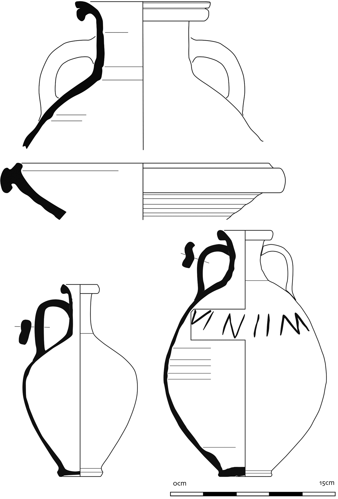
The earliest ceramic production attested at Famars dates from the end of the first century c.e. From this period onwards, various workshops, distributed over the western part of the town, manufactured oxidised pottery (particularly flagons and small amphorae), as well as micaceous table wares from the second half of the second century c.e. onwards. The production of oxidised flagons using calcareous clays followed the abandonment of production within the civitas capital Bavay. Thin-sectioning and chemical analysis of clay mixtures showed that Bavay and Famars potters used the same raw material and the same clay treatment, suggesting the movement of potters from the capital to the town of Famars, where the riverine network enabled cheaper transport than was available via roads.Footnote 41 It was only in the third century that mortaria (fig. 6) were made at Famars, perhaps offsetting the shortfall that may have arisen following the abandonment of the Pont-sur-Sambre workshop.Footnote 42 Ceramics fired in a reducing atmosphere were also made in the town. They comprise utilitarian vessels for cooking or preservation and serving (cooking pots, platters, globular pots, large bowls and lids), but also beakers and other vessels for display. There was a clear shift in the consumption and production pattern at the end of the first century c.e., when local potters started producing grey wares using the typical south Nervian repertoire. During the first century c.e., cooking wares were imported in large quantities from the Cambrai region using a kaolin clay, but by the end of the second century, local sandy productions had gradually taken over part of the local market.Footnote 43 Imports from production regions such as Cambrai, Arras or Sains-du-Nord became rare as local potters evolved to standardised forms and clay admixtures, reaching what was probably considered a high standard of production.
Examples of oxidised common ware productions from Famars. (© S. Willems, Art and History Museum, Brussels/UCLouvain)

The last kilns, producing grey cooking wares as well as grey table wares, were still operational in the early fourth century c.e., when domestic settlement areas were abandoned to make space for the construction of the fortification.
The existence of two systems of production was clearly demonstrated at Famars. The first seems to be the result of seasonal activity by ‘peasant’ potters, in addition to other tasks carried out the rest of the year.Footnote 44 They mainly produced grey cooking wares for the local market, using a kiln situated in the back of their yard. Each kiln was positioned within a specific land plot, containing a house, sheds, water pits and waste pits. Judging from the consumption of meat, pottery refuse and lost items (testimonies of a relatively affluent population), it seems to have been a source of extra income. Although no ancient text concerning the status of peasants or potters mentioning this production system has ever survived, the system is well known for the medieval and modern periods.Footnote 45 Recently, the Roman Peasant Project showed that peasants in Italy combined different production functions in their farms, such as cereal and food production, tile and pottery production, some of it meant for the markets.Footnote 46 This seems to have been the case for sites such as Podere Marzuolo, where Italian samian wares were produced, or Tombarelle, where the farm showed a clear handicraft component. It is more than likely, therefore, that this part-time manufacture would have been in existence since antiquity on a larger scale to fill seasonal lulls in agricultural activities, and to gain additional income.
Judging from the standardisation of grey cooking wares, it seems that potters fulfilled specific orders for an owner or a trader. Shapes could be copied by a craft worker with the necessary know-how, but the normalisation of clay admixtures attests to a common supply chain and a shared approach that was developed during two centuries of trial and error.Footnote 47 Such ‘occasional’ craft workers were perhaps unable to create a personal market while delivering the same goods as their neighbouring competitors. These potter-peasants, moreover, could have been under the control of craft workers manufacturing items according to the second production model.
The second pattern involves full-time pottery craft work, which can sometimes border on industrial production. Large buildings were used for the storage and drying of morphologically very standardised products. Several kilns were placed adjacently to optimise space within the same land plot. They were transformed and refurbished to become more efficient. When abandoned, they were replaced by a new kiln built on the same spot. This system has only been identified at Famars for oxidised pottery (flagons, small amphorae and mortaria). Some types of amphorae retrieved in rubbish dumps, discarded because of over-firing and warping, were never observed inside the 20 ha exposed town surface. Their absence proves that they were containers exclusively meant for export.
Like the traditional long-distance trade amphorae, the local jugs and amphorae were not traded for aesthetic reasons, but probably for their contents. It is impossible, however, to know what foodstuff was sent out of Fanum Martis without any analysis of content of jugs found at places of consumption. A first analysis of local amphora distribution suggests transport towards the Lower German limes.Footnote 48 Possible export towards Britannia using the Scheldt river should be investigated, as data for this region are currently lacking.
Spatial distribution of craft activities
In contrast to some quite widespread thinking,Footnote 49 it seems increasingly obvious that craft activities were not relegated to the periphery of urban space because of potential nuisance or hazards. They were distributed within the town, intertwined with the urban fabric,Footnote 50 but also near religious and administrative premises.Footnote 51 Specific needs, for instance a regular water supply demanding the construction of an aqueduct, meant that some craft activities such as tanneries required a particular location. By contrast, others (such as butchery, bone marquetry or glue-making) would be gathered in the same sector to minimise transport and include them into an operational chain or production line. These groupings thus create links between activities. Tanneries with specific needs and processing dead animals attracted other professions focusing on this ‘raw material’. Others still needed space to develop, for instance carpentry and woodworking. Some activities also had to take place at the location of raw material extraction (iron processing or stone working), at times creating small satellite centres around the place of manufacture.
At Famars, the north-western sector harboured many activities from the second to the early fourth centuries c.e.: notably extraction of raw materials (quarries), pottery production, cereal processing and craft activities related to animal products (hides, bones for the manufacturing of glue, as well as horn and even leather. Could this production line (chaîne opératoire) of glue, leather and meat have been justified for sole consumption at Fanum Martis and its close countryside, or was this meant for broader trade concomitant with the distribution of local amphorae, whose distribution over long distances is well attested?
The craft activities discussed above (ceramic production, tanning, glue-making, horn-working) were established according to the needs of the time and the practicability of the location in which they were to take place. Constraints could change and the activities could be displaced, except for those relating to the extraction of raw materials (fig. 7a and b). Other areas of activities were identified in the town's north-east and south sectors, but these were not as long-lasting as those previously mentioned. Evidence of bronze working, glass working, pottery and lime production, as well as the processing of cereals, has been exposed.
Craft activities recognised within the settlement. (© R. Clotuche, Inrap)

THE DEPENDENCY OF COUNTRYSIDE ON TOWN (ANALYSIS OF LAND REGISTRIES) AND THE LANDS EXPLOITED BY FAMARS' AGRICULTURAL ESTATES
In addition to the archaeological evidence outlined above, it has also been possible to use the evidence from modern land registry axes to identify the ancient layout of the town. This aimed to identify the central core from which the plan of the Gallo-Roman town developed. Once the principal alignments of the Roman town (based on streets, ditches, fences, wall alignments, etc.) have been identified, it is possible to assess the extent of the peri-urban area directly linked to the ancient town by recognising similar alignments in the landscape. This was supported by regression analysis of land registers, undertaken to assess the territory potentially developed by the town's agricultural estates.Footnote 52
Excavations over large areas and at various locations in the modern town have permitted the identification of the ancient urban grid, whose orientation varied very little during the three centuries of occupation. Buildings and land plots were laid out along streets, following different axes according to their position in the town (fig. 7).Footnote 53 These axes were preserved between the Roman town's abandonment and the nineteenth century. They can be identified both in the north-western (Technopôle) and north-eastern (La Rhonelle) sectors, as well as in the central quarter (around the Roman baths).Footnote 54 Recent surveys in the city's south-eastern part have shown the same organisational system.
This type of enduring orientation is noticeable at several other Gallic towns from antiquity where the ancient structure has been preserved until the present day. It is easy to identify in the civitas capitals (Amiens, Soissons, Chartres and Vieux)Footnote 55 or in large towns that have been the focus of research for many years (e.g. Mandeure-Mathay and Grand).Footnote 56 The extensive excavations of antique Fanum Martis may permit the identification of the same phenomenon and it was decided to test this through analysis of a range of cartographic data.
The demonstration involves checking whether similar observations can be made at Famars, where the ancient settlement was much larger than the present-day town. The Gallo-Roman town grew as its economy developed, adapting to the uneven topography of the area.Footnote 57
The modern town of Famars developed substantially only from the 1960s, when its earlier pattern of land divisions was altered by the creation of several pavilion neighbourhoods, which completely transformed the ancient landscape. The availability of maps from before the twentieth-century land consolidation and regrouping is therefore imperative to recover the oldest possible grid of plots. Fortunately, the 1830 and 1831 ‘Napoleonic’ land registers for Famars and neighbouring municipalities (Artres, Quérénaing and Maing) are held by the Nord departmental archives.Footnote 58 All the sheets for each of the municipalities concerned were digitised and then vectorised using Quantum GIS (QGIS) software.Footnote 59 The various plans were calibrated on the basis of permanent reference points (bridges, roads, crossroads, churches, etc.) using recent surveys that already had geo-referencing.Footnote 60 A total of 1,353 plots were mapped on the general plan (fig. 8). It appears that many of the ancient axes correspond to the orientations still present on the ‘Napoleonic’ registers. The organisational similarity between them suggests that the ancient grid remained fixed in the modern landscape crossing the communal boundaries of the nineteenth century. In this way, it is possible to recognise how the ancient town must have been organised. The formulas appended to the Quantum GIS software can be used to select axes (walls, plot boundaries, etc.) with similar orientations. These seriations indicate the breaks between the different systems of organisation.
Roman axes identified on a map dating from 1830. (© R. Clotuche, Inrap)

This is not a centuriation system, as has been proposed elsewhere for northern Gaul,Footnote 61 but rather a cadastral system based on Roman measurements, organised and evolving according to the local topography, as in the countryside.Footnote 62
These surviving ancient alignments can be seen across the area of the Roman town. The orientation of the land divisions established in the Technopôle area in the late first or early second centuries c.e. survived to the north and south of the road leading to the Escaut/Scheldt river. Modern-day plots run parallel to ancient walls and to alignments of post-holes that divided ancient space. To the east, the axis of the aqueduct marking the town's northern extension in this sector has likewise been preserved as a modern-day boundary. The orientation of walls nearby, though slightly different, is also embedded into recent and current land plots. Likewise in this sector, though the plan of the semi-circular cavea of the theatre is not visible in the ‘Napoleonic’ land registry, the location and alignment of the scaenae frons was retained in plot divisions.
These multiple observations confirm that the orientation of ancient land divisions survived until the land regroupings and consolidations of the late twentieth century. Surveys have established the existence of a system of organised land division, which did not follow a single orthogonal grid over the whole of the town, but was laid out per district or part of a district (fig. 9). The crossroads near the thermal baths generally correspond to the point of origin of the organisation, suggesting a cardo and a decumanus.
Correspondence between Roman and modern axes. (© R. Clotuche, Inrap)

The pattern of alignments identified at the heart of the town extends beyond areas where remains from antiquity were discovered. The alignments of both ancient and modern land plots appear to reflect the Roman road axes. Hard surfaces outside those recognised within the urbanised area, identified by geophysical and aerial prospection, showed that land plots abided by the same alignments as the urban area.
Towards the north, the grid was interrupted by the foot of Mont Houy, where the pattern of land plots appears to have followed the topography rather than a regular lay-out. Towards the south-west, it was identifiable until reaching the ‘Ravin de Caumont’ located in the municipality of Maing. Beyond that brook, another grid developed with an entirely different orientation. It was made up of small spaces occupying a regular slope of land to the south of the ‘Rouge Mont’ and the Escaut/Scheldt river. To the south-east, a land-plot grid extends around the village of Artres. Patterning is less regular than on the territory of Famars, but an ellipse surrounding the village centre can be noticed. In the current state of our documentation, it is impossible to identify (or date) the poles of attraction that influenced these (two changes) irregularities in the grid observed on the territory of Artres and Maing.
To the north-west, around Mont Houy and the Fontenelle wood, a settlement zone was formed, related to the existence of a quarry and the abrupt slope towards the Escaut/Scheldt river. The Mont Houy plateau was potentially arable for farming necessary to the town.
Regression analysis of the land registries of 1830 and 1831 clearly shows that the ancient pattern covered a greater surface than the current municipality of Famars. It extends over more than 700 ha, covering the modern-day municipalities of Famars, Maing and Artres. The 700 ha directly depending on the town to the west of the Rhonelle river, as well as the spaces to the east of the watercourse whose surface cannot be quantified, must have provided the largest proportion of cereals. Surveys have not revealed the existence of constructions of farmstead- or villa-type occupation in this area, suggesting that it was meant entirely for agriculture and was directly connected to the town. When one adds these areas east of the Rhonelle, the territory is closer to approximately 1,000 ha (fig. 10). It is also possible that the few farmsteads or villas in the vicinityFootnote 63 brought their produce to this centre to take advantage of the opportunities for commercial distribution afforded by the Escaut/Scheldt and Rhonelle rivers.
Recognised cadastral systems around Famars. (© R. Clotuche, Inrap)

It is obvious that the more distant countryside must have been used by the town's inhabitants to provide for their needs or for the trade of foodstuffs.Footnote 64 The area to the east of the Rhonelle river, where no settlement has been identified, can be seen as a good example. Located close to Fanum Martis, it is likely that these lands were exploited by farmers nearby for agriculture or livestock husbandry. It is not impossible, however, that in years to come, small settlements linked to the town will be brought to light.
Although the town of Asse (belonging to the Nervii and sheltering farming activities) has not been the focus of such intensive research as regards its territory, one should note that, like Famars, it was not connected to any villa within a radius of 30 km, whether by roads or navigable rivers. It is therefore possible that a similar organisation developed around this vicus.
AXES OF DISTRIBUTION
Recent research has shown that the common oxidised pottery of Famars (jugs, amphorae, mortaria and facepots) was exported not only to neighbouring towns, but also to the Lower German limes on the Rhine, the western and northern coasts at Boulogne, and Oudenburg (fig. 11).Footnote 65
Distribution of pottery produced in Famars. (© R. Clotuche, Inrap/S. Willems, Art and History Museum, Brussels/UCLouvain)

For the export of these products, several roads from the town linked it with Bavay, Arras and Cambrai, but also to the Escaut/Scheldt river. It appears, however, that the industrial manufacturing locations established in the early first century c.e. by potters from the Lyon region (Lugdunum) at BavayFootnote 66 were abandoned around the end of the same centuryFootnote 67 and transferred to two workshops: Pont-sur-Sambre for the production of mortaria; and Famars for flagons and amphorae, both on rivers (respectively the Sambre and the Escaut/Scheldt).
This decision probably reflects commercial interests. There is no large site currently known on the rivers, but a stone structure (possibly a quay) was identified on the Escaut/Scheldt to the west of Fanum Martis, as well as a pier in Valenciennes at the Escaut/Scheldt–Rhonelle confluence, suggesting points at which goods could be loaded onto barges.Footnote 68 Bavay had only roads at its disposal on which ox-carts could transport much less than was possible on a barge. The two sites chosen for the manufacture of pottery belong to the Escaut/Scheldt basin in the first instance, and to that of the Meuse in the second. The mouths of these two watercourses, close to those of the Rhine, consequently permitted a large-scale diffusion of products, from this sector of the Nervian territory, towards the north and west. As for other destinations, it seems that roads were favoured.
Depictions of Rhône barges (at Cabrières d'Aigues and Colonzelle)Footnote 69 show they were loaded with a variety of goods. It is possible, therefore, that the cereals of the Nervii, whose trade towards the Lower German limes is attested by the Nijmegen inscription of the altar of M. Liberius Victor (a wheat merchant),Footnote 70 were accompanied by small amphorae as well as other local products. The transportation of cereals by boat towards the limes is shown by the wreck of a ship discovered on an ancient branch of the Rhine, near the fort of Laurium at Woerden in the Netherlands.Footnote 71 This vessel, which sank in the late second century c.e., carried a cargo of husked and hulled emmer wheat. The presence of weed seeds, and more specifically of Orlaya, led the authors to locate this wheat's provenance in the Belgian loess areas. While the supply of the Roman army in meat products in the Rhine delta was generally organised at a local level, archaeobotanical studies carried out by L. Kooistra on periods covering the last quarter of the first century b.c.e. until the 140s c.e. demonstrated that most cereals came from southern regions.Footnote 72 Moreover, the agricultural production on the sandy soils of the very north of northern Gaul did not change during the Roman period, despite the development of the Roman villa architecture and the rise of a hierarchy between the rural settlements.Footnote 73
The insertion of Famars within the army's supply networks is suggested by the discovery of an oval intaglio at the Technopôle site in 2012, made of red jasper, which displayed a very finely made motif: a modius on legs surmounted by weighing scales. The latter itself bore four wheat ears and two cornucopias (fig. 12). This motif is above all related to wheat (both the four ears and the modius are used in measuring cereals), but also to prosperity (the two cornucopias). The depiction of a modius could indicate the presence of an imperial civil servant at Fanum Martis, with responsibilities in the Annona service.Footnote 74
Jasper intaglio with representation of a modius, wheat ears and cornucopia. (© S. Lancelot, Inrap)

From an archaeozoological viewpoint, it is easier to find traces of imports rather than exports of products of animal origin since exports are materialised by absences and deficits only. Moreover, supplying meat to the armies was probably done on the hoof, particularly involving bovines (since cattle can cover greater distances than pigs). However, exports on the hoof leave no trace in the zone of origin. Based on the archaeobotanical evidence and pottery consumption data, we know that a supply network from Famars towards the limes existed, and one can assume that meat supply also used the same network.Footnote 75 In the same way, exports of animal products (such as leather, wool, or bone objects) are extremely hard to identify, apart from in specific cases of recognised workshops. Indeed, not only are provenances not discernible, but the organic raw materials (for instance leather, wool and other perishable animal by-products like cheese) are only very rarely, if ever, preserved. Consequently, we have relied on faunal data.
The import of specific animal products, such as marine fish or shellfish, is more obvious. Their source has been determined by means of isotopic techniques,Footnote 76 which allow us to distinguish large-scale provenance (Atlantic versus the North Sea, for example). Likewise, the discovery of exotic animal remains (like a lion phalanx at Famars) indicates importation from distant lands (although whether alive or as skins or other body parts is uncertain).Footnote 77 In certain cases, anomalies in body-part representation suggest imports, for instance in the case of large numbers of hams at Famars (where greater weights of femur and tibia bones were recovered in comparison to the rest of the skeleton) (fig. 13). At the scale of a town, however, over-representation of elements in a specific sector of the town can be compensated by absence in another. From this viewpoint Famars, with its three major excavated sectors, is a very interesting case. Indeed, both in craft quarters and in wealthier areas inside the town, one can notice a remarkable consistency in the supply and consumption of meat, particularly in terms of the over-representation of hams noted above. However, this does not tell us anything about the provenance of these animals or pieces of meat, whether they were local or from further afield, although texts explicitly refer to the export of hams and the travelling of pigs during the Gallo-Roman period, frequently over considerable distances (Martial XIII, 54, 2, speaking specifically of the Menapians; Varro, Rust. II, 4 speaking of delicious hams and sausages sent to Rome from Gaul). The absence of other anatomical elements and the over-representation of hams suggest that hams were imported and consumed in Fanum Martis on a large scale.
Comparison of the proportions, in weight of remains, of the front and hind limbs of pigs, Famars, Technopôle site (© J.-H. Yvinec, Inrap)

Advances in archaeozoological techniques also allow us to imagine new research prospects. Isotopic or morphometric techniques, applied to archaeozoology, are beginning to yield data on the relation of animals to regional stocks. It has, for example, been possible to highlight different geographical populations among Gallo-Roman pigs,Footnote 78 suggesting that it will be possible to define exports with greater precision in future.Footnote 79 Finally, the increasingly cheap and more precise use of genetics is the most encouraging avenue for the future. These advances makes the preservation of complete assemblages of bone from archaeological sites an imperative, given the possibilities for future analyses.
In the absence of DNA or isotopic analyses, the present state of research suggests that the development of small-scale industrial or quasi-industrial infrastructure for the processing of bovine meat and its by-products (e.g. horn, hides, bone) in towns (Famars in particular) was associated with the manufacture of exportable animal products. These products may have been meant for regional markets, notably for the main centre, Bavay, which must have absorbed part of the animal product of the area, delegating its production to nearby secondary towns. A distribution reaching the Lower German limes, reflected in the transport of pottery, can also be imagined.
The supply of troops in anticipation of the conquest of Britannia, as well as of those garrisoned on the Rhine limes, depended heavily on northern Gaul's resources.Footnote 80 During the following centuries, there was no reduction in the demand for manufactured products or foodstuffs from the territory of the Nervii, as shown for cereals by the Nijmegen inscription. The town of Fanum Martis, ideally connected either by land roads or navigable routes, certainly took part in this supply of food to the limes.
CONCLUSION
Recent research on the distribution of pottery from Fanum Martis has identified commercial and trade networks. Amphorae and jugs were traded not as luxuries or due to intrinsic qualities, but for their contents (whatever their nature). They were therefore part of a distribution network of goods, along with other merchandise. Watercourses (the Escaut/Scheldt and the Sambre/Meuse) appear to have been the best communication thoroughfares, permitting transport to the Lower German limes and, inversely, imports of eastern products towards Fanum Martis.
The presence of agricultural structures and buildings, as well as proof of cereal processing in the town itself, confer a peculiar function on Fanum Martis. It was not only a place where raw materials were transformed into goods for distribution, but was also a centre for production of those raw materials. The absence of archaeobotanical remains that can be attributed to fruit trees leads to the conclusion that the city's suburbs were meant for cereal production only, rather than for orchards (as are frequently known from other towns). The discovery of an intaglio relating to the deduction of the Annona indicates that this urban centre could have been a central place for cereal collection and distribution, and even a specific provider for soldiers stationed on the Lower German limes. Faunal remains are more difficult to follow and would require isotopic or DNA analyses of animal bones from consumption sites. The substantial mass of worked animal matter, however, is indicative of the production of meat and its by-products for export.
Notwithstanding the sometimes partial nature of the evidence, the factors outlined above suggest that Fanum Martis could have been a major centre for trade in northern Gaul. It is hoped that future research will corroborate this hypothesis.