
Introduction
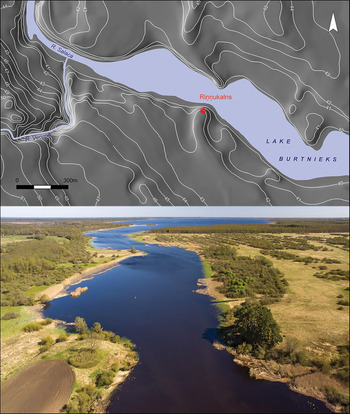
Riņņukalns is located on the River Salaca, at its outflow from Lake Burtnieks in present-day Latvia (Figure 1; Bērziņš et al. Reference Bērziņš2014: figs 1–3). Count Carl Georg von Sievers discovered and excavated the site in the 1870s, identifying Riņņukalns as a shell midden, analogous to those investigated previously in Denmark. Unlike the Danish middens, however, Riņņukalns is an inland site, yielding freshwater mussels and fish. Following Sievers, further trenches were opened at Riņņukalns in the late nineteenth and early twentieth centuries (Bērziņš et al. Reference Bērziņš2014).
Top) outlet of the River Salaca from Lake Burtnieks, showing the location of the Riņņukalns site; bottom) aerial view—the site is in the pine grove at the lower right (photograph by M. Kalniņš).

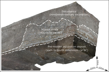
Riņņukalns remains the only known inland Stone Age shell midden in North-east Europe. Trial excavation in 2011 revealed a stratified midden deposit surviving in part of the site (Bērziņš et al. Reference Bērziņš2014). A larger-scale excavation across the central part of the site in 2017–2018 showed that the midden itself—now dated to the later fourth millennium BC (Bērziņš et al. Reference Bērziņš2014; Brinker et al. Reference Brinker2020)—represents a relatively late phase in the site's history. The midden strata seal a thick occupation layer that is almost devoid of shell and that began accumulating from the sixth millennium BC or earlier (Figure 2).
Stratigraphic sequence at Riņņukalns; south-eastern part of trench one, 2017–2018 excavation (photogrammetry by M. Kalniņš).

Despite comprehensive wet sieving and flotation during the new excavation campaign, Riņņukalns yielded no evidence of domesticates other than dog (Canis familiaris). Rather, the evidence points to the paramount importance of freshwater aquatic resources. The site itself is in a prime fishing location and has yielded abundant remains of fish and freshwater mussels. Furthermore, stable isotope analysis of human remains indicates the primacy of freshwater protein sources (Brinker et al. Reference Brinker2020).
Given its long chronological span, the Riņņukalns site provides an opportunity to study long-term change in ceramic production and function. The knowledge of pottery-making spread across North-east Europe, reaching the eastern Baltic region in the later sixth millennium BC (Kriiska et al. Reference Kriiska2017; Courel et al. Reference Courel2020). Here, the earliest pottery, usually referred to as Narva Ware (or Osa Ware in Latvia), consists of modestly decorated pointed-base vessels, or shallow oval bowls, both forms with mostly shell and plant temper (Dumpe et al. Reference Dumpe, Bērziņš and Stilborg2011; Kriiska et al. Reference Kriiska2017).
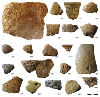
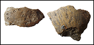
At around 4000 BC, a new type of technologically and morphologically distinct pottery appeared in the region: ‘Typical Comb Ware’, which is characterised by rock-tempered, generally round-based vessels that are more fully decorated, with horizontal rows of comb imprints and deep pits (Kriiska Reference Kriiska1995: 112–13). Ceramic assemblages from the late fourth-millennium BC contain a range of ‘hybrid’ pottery wares, exhibiting traits recalling both Narva Ware and Comb Ware. These are frequently tempered with shell and other non-mineral materials, indicating a possible continuation of an indigenous technological tradition, combined with decorative compositions and rim forms deriving from Comb Ware (e.g. Bērziņš Reference Bērziņš2008: 40–41 & 145). All the wares mentioned above are represented in the samples we analysed from Riņņukalns (Table 1). The late fourth-millennium BC (later Middle Neolithic) ceramics from the midden layers constitute the largest proportion of our samples, exemplifying the ‘hybrid’ ceramics of this period. We identified, on typological grounds, most of the sampled sherds from the thick occupation deposit underlying the midden as either Early Neolithic Narva Ware or Comb Ware; in some cases, a clear chrono-typological classification was not possible due to a lack of diagnostic features. The Riņņukalns pottery was carefully decorated with a wide variety of motifs, mainly impressed and incised, using geometric tools, cord stamping or porpoise teeth (see Bērziņš & Dumpe Reference Bērziņš and Dumpe2016); occasionally, sherds were also painted (Figure 3).
Sherds from Riņņukalns sampled for petrographic analysis (numbers refer to samples in Table 1). Scale in centimetres (photographs by V. Bērziņš).

Analysed pottery from Riņņukalns. Petrographic fabrics are described in Table S1. ORA = organic residue analysis; Ci = ceramic powder drilled from the internal surface; Fi = food crust on internal surface.

Here, we discuss the results of our petrographic, microstructural and compositional analyses of ceramic fabrics, and biomolecular analysis of organic residues within these vessels. These lines of evidence allow us to reconstruct the chaîne opératoire and function of pottery at Riņņukalns. The chaîne opératoire, including clay selection, addition or removal of inclusions (tempering/depuration), vessel forming and surface treatment, and firing temperatures/conditions (Rice Reference Rice1987), reveals technological choices in everyday life, in turn reflecting social organisation and connectivity. Pottery function attests to the processing and consumption of natural resources, thus informing reconstructions of the subsistence economy. Both technology and function can indicate how pottery was regarded in this society: whether it was mainly utilitarian or primarily an expression of aesthetic or symbolic values.
While mobile hunter-fisher-gatherers would be expected to make expedient technological choices and an undifferentiated use of pottery, the midden at Riņņukalns appears to reflect a higher degree of sedentism. We therefore combine technological and functional analyses of the ceramics from this unusual setting to address the following questions:
1) Did the Riņņukalns hunter-fisher-gatherers use pottery only for cooking?
2) Did they make vessels for specific uses and, if so, did they use specific clays and tempers to make containers designed to process different resources?
3) Did any of these aspects change between the pre-midden and midden phases?
4) Was the role of pottery in the midden setting distinct from that at other hunter-fisher-gatherer sites in the region?
Materials and methods
Twenty sherds from the 2017–2018 excavations were sampled for petrographic analysis and 20 for organic residue analysis. To maximise the overlap between the two types of analyses, 13 sherds were analysed using both methods. This selection covers the full range of identifiable macro-fabrics, surface treatments and decoration (Table 1). Visible surface residue was considered when selecting sherds for organic residue analysis. Three lumps of unfired clay and an unfired sherd (RK10032), all from the shell midden layers, were also examined petrographically (Table 1; Table S1 in the online supplementary material (OSM)).
Uncovered, polished thin sections of the 24 samples were analysed by polarised microscopy to describe the ceramic pastes (petro-fabrics) and to investigate the steps of the chaîne opératoire, such as clay selection and processing, surface finishing and firing temperature (Spataro Reference Spataro2019). A Hitachi S-3700N variable-pressure scanning electron microscope with energy dispersive spectrometry (SEM-EDX) was used to study the microstructure and chemical composition of these samples (Table S2). SEM backscattered electron (BSE) images of the fabrics complemented polarised microscopy. Clay and shell microstructures were studied at magnifications of ×1.0–2.0K to estimate firing temperatures. To investigate the chemical composition of fabrics, four SEM-EDX bulk analyses (each covering approximately 1.5 × 1.0mm) were undertaken on each sample, with additional analyses of painted and ochre layers. Principal component analysis (PCA) of the compositional data was employed to compare ceramics within the midden to those from pre-midden layers. An EDX compositional map was used to examine the elemental concentrations on the painted layer of sample RK2419.
Twenty-three samples (four food-crust and 19 ceramic powder; see Table S3) from 20 sherds were analysed for lipid residues. Lipids were extracted from approximately 1g of ceramic powder or ~20mg of food crust using acid-catalysed methylation with methanol (MeOH) and sulphuric acid (H2SO4), and heating on a heating block at 70°C for 4h (Craig et al. Reference Craig2013; Heron et al. Reference Heron2015). After heating, lipids were extracted with n-hexane (3 × 2ml) and dried under a gentle stream of nitrogen at ~37°C. Samples were dissolved in 100μl of n-hexane with the addition of 10μg of internal standard of C36 (n-hexatriacontane). The samples were analysed with GC-FID (for lipid quantification), GC-MS (for biomolecular characterisation) and GC-C-IRMS (to measure the δ13C value of C16:0 and C18:0 fatty acids; for details, see the OSM).
Results: the chaîne opératoire
Clay sources
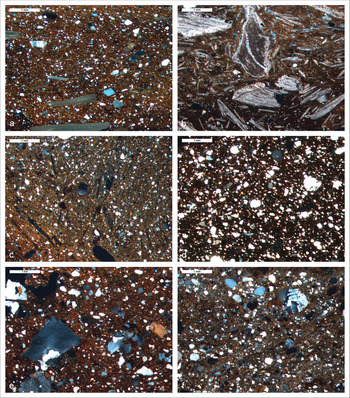
The 20 sherds were divided into five petro-fabrics (Tables 1 & S1; Figure 4). All the vessels from the midden were made with similar clays (fabrics 1 and 2) to that used for the unfired potsherd. All pots, including the pre-midden sherds (fabrics 3–5), were made with clays containing similar sand (by size, sorting and distribution) to the clay lumps found in various midden layers. Fabric 5, however, contains abundant biotite, which is rare in fabrics 1–4, and could indicate that sand was added to the clay. SEM-EDX results (Table S2) were analysed by PCA, omitting calcium oxide. We wanted to assess the clays used to make the ceramics, rather than the added tempers. As shells are made of calcium carbonate (including CaO), PCA would have separated shell-tempered sherds from all other samples, regardless of the clay composition.
Photomicrographs of thin sections of: a) RK0399 (petro-fabric 1) with fine sand inclusions and shell temper; b) RK0022 (petro-fabric 2) with abundant shell fragments and scarce fine quartz sand; c) RK1043 (petro-fabric 3) with voids left by the burning of (possibly) plant matter; d) RK2392 (petro-fabric 4) with abundant sand inclusions; e) RK1284 (petro-fabric 5), with poorly sorted sand inclusions and rock fragments that include apatite; f) RK00216, a clay ball, with poorly sorted sand. Photomicrographs were taken in cross-polarised light, except image b, which was taken in plane polarised light (© British Museum Trustees; figure by M. Spataro).

Figure 5 shows that the raw materials used to make the sherds from the shell midden differ chemically from those used for the pre-midden ceramics. Petro-fabrics 1–2 are chemically similar to the unfired sherd (RK10032), indicating that these sherds were locally made. The pre-midden sherds (fabrics 3–5) are chemically similar to the unfired clay lumps found in the midden, again suggesting local or regional provenance.
Principal component analysis (PCA) of the averaged SEM-EDX data of four bulk analyses per sample; components one and two, which together account for 57 per cent of variation (PCA of the correlation matrix was performed using PAST v.3.18; Hammer et al. Reference Hammer, Harper and Ryan2001). Calcium oxide, the concentration of which would be exaggerated by the shell temper, was omitted. Symbols represent petro-fabrics and reference material (Table S2) (figure by M. Spataro).

Clay processing and tempering
Most samples contained naturally occurring clay pellets, coarse iron-rich pellets, bone fragments (<0.5mm) and voids left by fine plant matter, suggesting that clays were not thoroughly processed prior to vessel shaping. Various materials were used as temper: finely crushed shells (<1mm, average 0.5mm) in fabrics 1–2; plant material (and/or shell?) in fabric 3; sand or no temper in fabric 4; and sand and intrusive rock fragments in fabric 5.
Forming and finishing
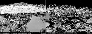
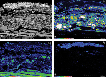
Most samples have oriented clays (clays in which the long axes of inclusions are approximately parallel), indicating that the clay was manipulated and the vessels possibly formed by coiling. Some thin sections show smoothing or polishing of the exterior surface, or traces of ochre on the interior surface. One midden sample (RK2419) was painted red on the exterior surface and red-coated on the interior surface, and was probably polished before painting. SEM-BSE images and chemical data (Table S2 & Figure 6) suggest that the exterior paint was probably a depurated calcareous clay mixed with finely crushed hematite (Spataro Reference Spataro2019: 367–68; Figure 7); the interior red coating was possibly pure ochre.
SEM-BSE high-magnification images of sample RK02419: a) ochre layer on the interior surface; b) painted layer on the exterior surface (© British Museum Trustees; figure by M. Spataro).

SEM-EDX X-ray map of the painted layer and body paste of sample RK02419: a) mapped area; b) elemental map for silicon, which is present throughout the body paste and concentrated in the sand inclusions; c) elemental map for calcium, which is concentrated in the shell temper in the body paste; d) elemental map for iron, which is concentrated in the painted surface (© British Museum Trustees; figure by M. Spataro).

Firing
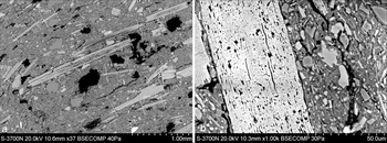
Fabrics one and two were fired at low temperatures, without vitrification, and the intact lamellar microstructure of the shell fragments indicates a firing temperature below 750°C. The shell fragments have intra-layers of small, rounded pores, which form at 650–700°C; larger pores (approximately tens of microns) would have formed at 750–800°C (Maritan et al. Reference Maritan, Mazzoli and Freestone2007; Figure 8). Intra-layer pores in the shell temper of the unfired sherd RK10032 suggest that the shells had been preheated, although pores can also occur naturally (e.g. endobenthic boreholes on the surface of shell fragments; Maritan et al. Reference Maritan, Mazzoli and Freestone2007: 538). In fabrics 3–4, clay filaments show initial vitrification, suggesting firing at ~800°C (<850°C). Plant matter, which in oxidising conditions burns off at 600–750°C (Rice Reference Rice1987: 88), was largely burnt out.
SEM-BSE high-magnification images of: a) sample RK00173 (petro-fabric 1) with fine fragments of crushed shells added as temper; b) sample RK10032 (petro-fabric 1), with fine intra-layers pores in a shell fragment (© British Museum Trustees; figure by M. Spataro).

Pottery function
The lipid yields from three food-crust and 20 ceramic powder samples vary considerably (for details, see the OSM and Table S3). Four sherd samples have a very low concentration of lipid (below the interpretability threshold given by Evershed (Reference Evershed2008)), but do not differ significantly from the other samples. GC-MS analysis shows lipid profiles typical for cooking animal-based commodities: fatty acids, especially C16:0 and C18:0, are the most abundant compounds in the extracts. GC-MS also allows biomarker-based tentative identifications of the origin of lipids in 20 samples. Cholesterol or its derivatives, potentially indicating animal products, is present in 19 samples. Six samples demonstrate aquatic biomarkers: ω-(ο-alkylphenyl) alkanoic acids, with carbon atoms ranging from C16 to C20/22—formed during the heating of polyunsaturated fatty acids—along with at least one isoprenoid fatty acid (Hansel et al. Reference Hansel, Copley, Madureira and Evershed2004; Craig et al. Reference Craig2007). These, as well as a partial suite of aquatic biomarkers in one sample, indicate that substances of aquatic origin (fish or other aquatic animals) were processed.
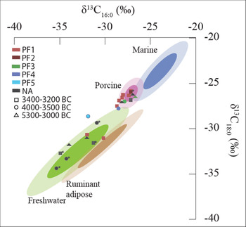
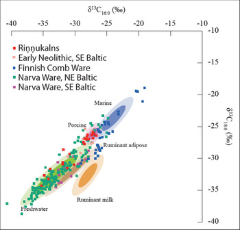
The δ13C values of C16:0 and C18:0 fatty acids indicate two major food sources: freshwater organisms and porcine adipose tissues (Table S3 & Figure 9). Based on the δ13C values and the lowest palmitic to stearic ratio, ruminant fat is probable in one sample (Evershed et al. Reference Evershed2002), although the sample also falls within the freshwater reference ellipse and lacks further diagnostic biomolecules.
GC-C-IRMS results based on petro-fabric groups (coloured) and sherd chronology (shapes) of Riņņukalns pottery (eastern Baltic reference data based on Courel et al. Reference Courel2020, with 95 per cent (lighter) and 68 per cent (darker) confidence ranges); * indicate full suite of aquatic biomarkers (figure by E. Oras).

Discussion
Pottery fabric and function
In both pre-midden (pottery fabrics 3–5) and midden phases (pottery fabrics 1–2), most, if not all vessels were used as cooking pots. Lipid yield is not correlated with chronological phases or petrographic fabric. Aquatic and porcine ingredients occur in both phases, although pre-midden sherds appear to be more often associated with freshwater isotopic values, and the midden-phase sherds with porcine values (Figure 9). This pattern suggests a diachronic shift in emphasis in the use of pottery, but no functional association between fabric and food ingredients.
Pottery function and palaeodiet
Stable isotope and zooarchaeological data suggest that freshwater fish was the main source of dietary protein at Riņņukalns (Brinker et al. Reference Brinker2020), with occasional consumption of wild ruminants, beaver (Castor fiber) and perhaps dog. The consumption of freshwater resources (either fish or mammals (e.g. beaver; cf. reference material in Courel et al. Reference Courel2020)) is also well supported by lipid analysis. In contrast to the frequency of porcine isotopic values in pottery, only 24 fragments of wild boar (Suidae) bones or teeth are recorded, of which only three are definitely from the midden layers (K. Ritchie pers. comm.). A few bones of brackish water or marine species of fish and seal have been identified (Brinker et al. Reference Brinker2020), the isotopic values of which could potentially overlap with the porcine ellipse. The absence of aquatic biomarkers in ‘porcine’ samples could be misleading, as this depends on heating temperature and time (Evershed et al. Reference Evershed, Copley, Dickson and Hansel2008). Thus, we cannot exclude that putative porcine fats in samples are the result of different food-processing practices (i.e. temperature, heating time, fermentation) of aquatic organisms.
Hunter-fisher-gatherer pottery technology
Pottery making is learnt through a ‘community of practice’, usually via the intergenerational transmission of skills (Gosselain & Livingstone Smith Reference Gosselain, Smith, Lindahl and Stilborg1995). Ceramic production by hunter-fisher-gatherers has been studied less intensively than that of agricultural societies, not least because pottery production is relatively uncommon amongst foragers. Nevertheless, as the evidence from Riņņukalns shows, hunter-fisher-gatherer pottery technology was not static. Pre-midden ceramics were plant- and rock-tempered, and were more highly fired than those from the midden phase; the latter were all shell-tempered, requiring lower firing temperatures. In order to understand whether midden-phase potters adopted shell tempering simply because shells were readily available, or as part of a wider ‘community of practice’, we considered other cases of shell-tempered or shell-midden ceramics.
Shell temper is often recorded in the eastern Baltic region at Neolithic sites without shell middens. In eastern Latvia, Early Neolithic Narva Ware at Osa was shell-tempered, and at Zvejsalas, shells (and also grass) were used to temper Middle Neolithic ‘Typical Combed Ware’. Later fourth-millennium pottery at Sārnate in western Latvia was tempered with plant and possibly shell and bone (Dumpe et al. Reference Dumpe, Bērziņš and Stilborg2011). In Estonia, Narva and ‘Typical Combed Ware’ pottery can also contain crushed shells (Kriiska Reference Kriiska1996: 374 & 377). Finally, shell temper appears in Zedmar Culture pottery, in present-day north-eastern Poland and Russia's Kaliningrad region (Gumiński Reference Gumiński1999).
Farther afield, however, shell temper was seldom used. At Okhta (St Petersburg, Russia), the earliest pottery (corresponding to Narva Ware) was tempered with stones, feathers and sand; early fourth-millennium BC ‘Typical Combed Ware’ was tempered with crushed volcanic rock, whereas mid-fourth-millennium BC Pit-Combed Ware was tempered with shells and feathers (Kulkova et al. Reference Kulkova2012; Kulkova & Kulkov Reference Kulkova and Kulkov2016). Plant and sand temper were used in Neolithic ceramics in eastern Belarus (Kulkova & Kulkov Reference Kulkova and Kulkov2016). Late fifth-millennium BC Ertebølle pottery in southern Sweden was tempered predominantly with crushed rock and occasionally grog, even at shell-midden sites (Jennbert Reference Jennbert2011).
Shell temper is likewise infrequently used in the pottery of Neolithic agricultural communities in Western or South-east Europe (Spataro Reference Spataro2019: 378–79); it is, however, present in late fifth-/early fourth-millennium BC Trypillia cooking pots and coarse wares in Ukraine (Starkova & Zakościelna Reference Starkova and Zakościelna2018), despite the lack of shell middens. Hunter-fisher-gatherer pottery from the Novoselivka III shell midden in eastern Ukraine was shell-tempered (Telizhenko Reference Telizhenko2018: 26), unlike pottery from shell-midden sites elsewhere. Locally made Neolithic Impressed Ware ceramics at Cabeço das Amoreiras in Portugal, for example, were either grog-tempered or not tempered at all (Diniz & Cubas Reference Diniz, Cubas, Bicho, Detry, Price and Cunha2015), while in fourth-millennium BC Japan, Jōmon ceramics made at sites with shell middens were rock-tempered, as was pottery made at nearby sites without shell middens (Kojo Reference Kojo1981).
The change to shell-tempering at Riņņukalns may have a parallel in eastern North America. Woodland-Mississippian ceramics share similarities in vessel form, decoration and function with early North-east European pottery (Piezonka Reference Piezonka2015: 236, 239 & 254–56). The increasing use of shell temper in the Late Woodland/Early Mississippian period (c. AD 700–1100) has been studied intensively and has stimulated experimental research into the functional characteristics of shell and other carbonaceous materials as temper (Feathers Reference Feathers2006).
Carbonaceous tempering materials, such as shell, improve the workability of clay; calcium ions increase flocculation, stiffening soft, sticky clay to allow it to be more easily worked, thereby permitting a wider range of vessel shapes and sizes (Herbert Reference Herbert2008). Shell can easily be prepared for temper (Bērziņš Reference Bērziņš2008: 178). After burning at a low temperature, shell crumbles readily without the pounding required to comminute limestone or bone. In contrast to angular or rounded quartz temper, platy tempers, such as shell and fibrous tempers maximise toughness by increasing the dissipation of energy through the deflection and bifurcation of cracks at interfaces between elongated inclusions and the clay matrix (Tite et al. Reference Tite, Kilikoglou and Vekinis2001).
The workability of the fabric and increased toughness of the fired vessel could have been the reason for the growing use of shell temper at Riņņukalns: a highly workable fabric would have facilitated the production of large, thin-walled vessels; and thermal-shock resistance would have been a prime consideration if pottery production was geared predominantly towards cooking vessels. Nonetheless, all the pottery at Riņņukalns was used for cooking, regardless of temper type.
It is crucial to fire shell-tempered pottery at a low temperature because calcite decomposes at 750–800°C, leading to spalling (Herbert Reference Herbert2008). This is a serious risk not just with kiln- or pit-firing, but also with open firing, as bonfire temperatures can exceed 900oC (Rice Reference Rice1987: 156–57). It is therefore significant that shell-tempered pottery from the midden phase at Riņņukalns was fired at a lower temperature than the earlier material. The widespread adoption of shell tempering in Woodland-Mississippian pottery has likewise been linked to a change in firing technology (Feathers Reference Feathers2006), although presumably potters would have adapted the firing regime to the requirements of the fabric, not vice versa.
Pottery use at Riņņukalns in regional context
Comparing the isotopic measurements of C16:0 and C18:0 fatty acids at Riņņukalns with equivalent data from adjacent regions and periods (Figure 10) reveals some notable tendencies. The use of freshwater resources dominates among the earlier Narva Wares in both Estonia and Latvia (Oras et al. Reference Oras2017; Courel et al. Reference Courel2020), where the increase in samples plotting in the porcine ellipse seems to coincide with the introduction of Comb Ware. A similar pattern of pottery use—for either porcine or freshwater resources—is seen in Early Neolithic inland pottery in Lithuania, while the Narva Ware there has considerably more examples with ruminant adipose fats. Comb Wares from coastal sites in Finland display a somewhat different pattern, with a more equal representation of marine and ruminant adipose fats (Cramp et al. Reference Cramp2014; Pääkkönen et al. Reference Pääkkönen, Bläuer, Evershed and Asplund2016). Thus, during the Comb Ware phases in the eastern Baltic, we find similarities in combined aquatic and terrestrial source exploitation, but divergences in the specific preferred food sources. The direct effects of site location (coastal or inland) on these food-procurement preferences, however, requires further testing.
Cross-regional pottery use in the eastern Baltic (additional data from Cramp et al. Reference Cramp2014; Pääkkönen et al. Reference Pääkkönen, Bläuer, Evershed and Asplund2016; Oras et al. Reference Oras2017; Courel et al. Reference Courel2020; plotted on eastern Baltic reference data based on Courel et al. Reference Courel2020, with 95 per cent (lighter) and 68 per cent (darker) confidence ranges) (figure by E. Oras).

Ochre in pottery
The sherd from Riņņukalns featuring a red ochre line on its exterior surface is the first known example of painted pottery in Stone Age Latvia, where only impressed, incised and occasional plastic decoration was previously recorded. Indeed, painting would seem inappropriate for cooking pots, whose exteriors become quickly sooted. Closer examination of pottery from previous excavations at Riņņukalns has revealed further sherds with traces of exterior red paint and sherds with red ochre smeared on the inside. Ochre paint is present on a miniature anthropomorphic figurine from Middle Neolithic Ģipka A on the Gulf of Riga, where an ochre-filled pot was also discovered (Loze Reference Loze2005). The ochre-smeared interiors of vessels from Riņņukalns suggest that they likewise served as receptacles for red ochre, and that such hunter-fisher-gatherer pottery was not used exclusively for cooking (although both samples with interior ochre, RK00022 and RK02419, also yielded lipid residues of animal—probably porcine—origin). Ochre coatings on pottery are more common in Russia and Finland in the pottery of the Valdai and Upper Volga cultures (Piezonka Reference Piezonka2015: 170 & 176), on Early Comb Ware (Skandfer Reference Skandfer2011: 169) and on Sperrings pottery (German Reference German, Jordan and Zvelebil2010).
Conclusions
Riņņukalns represents an unusual case of hunter-fisher-gatherers making and using pottery for cooking on an inland midden site. In both the pre-midden and midden phases, pottery was used to cook either fish or non-ruminant meat (probably wild boar, although few wild boar bones have been recovered), and palaeodietary evidence indicates that fish was the main source of protein in the midden phase.
Although vessels were used to cook specific ingredients (i.e. either aquatic or porcine), there is no evidence of a correlation between pottery fabric and function. While function did not change significantly between the pre-midden and midden phases, the technology of production did: pre-midden pottery is sand/rock- and plant/shell-tempered and sometimes over-fired, while all the midden-phase pottery is shell-tempered, and its firing was carefully controlled to prevent spalling.
Although the inland shell-midden setting is unusual, the role of pottery at Riņņukalns is mirrored at other hunter-fisher-gatherer sites in the region: similar ingredients (freshwater fish and non-ruminant meat) are recorded in fourth-millennium BC pottery from non-midden sites in the Baltic countries, whereas contemporaneous assemblages in Finland present a different pattern (marine species and ruminants). Similarly, the chaîne opératoire in the midden phase reflects trends in pottery technology in the eastern Baltic region that go beyond the site's inland shell midden setting and the ready availability of raw materials.
Returning to the questions posed at the beginning of our study, we conclude that the Riņņukalns hunter-fisher-gatherers used pottery mostly for cooking, that changes in ceramic technology can be detected between Riņņukalns’ pre-midden and midden phases in the fourth millennium BC, and that the site's inland setting is reflected in the food cooked. Freshwater resources were consumed at Riņņukalns, as well as porcine meat, whereas marine foods were combined with ruminant meat on coastal sites in North-east Europe, documenting both similarities and divergences in food-procurement strategies. Our results therefore contribute to wider research concerning the introduction of pottery, its technology and its function, among hunter-fisher-gatherers in other parts of the world.
Acknowledgements
The authors would like to thank Kenneth Ritchie for sharing results from his preliminary zooarchaeological report, John Meadows and Carl Heron for their helpful comments and critiques, and the two anonymous reviewers for their useful remarks. We would also like to thank Harald Lübke, Ulrich Schmölcke and John Meadows (ZBSA, Germany) as the principal investigators of the Deutsche Forschungsgemeinschaft grant, which funded these analyses.
Funding statement
The fieldwork at Riņņukalns and the analyses presented here were funded by the Deutsche Forschungsgemeinschaft (project 335674082). Ester Oras's work was additionally supported by the Estonian Research Council (personal research grants PSG492 and MOBERC14). Alexandre Lucquin's work and the GC-C-IRMS analyses were supported by the European Research Council (ERC) under the European Union's Horizon 2020 research and innovation programme (grant 695539: The Innovation, Dispersal and Use of Ceramics in NE Europe, PI: Carl Heron).
Supplementary material
To view supplementary material for this article, please visit https://doi.org/10.15184/aqy.2021.127