

Introduction
State interests and the movements of people across international borders is a topic of significant interest in contemporary Africanist literature (see, for example, Crisp Reference Crisp2000; Mitchell Reference Mitchell2012; Flahaux and de Haas Reference Flahaux and de Haas2016). Refuge populations, cross-border trade and labour migration have served as major foci of this literature. Pastoralist groups are commonly cited examples of groups who recurrently move across international boundaries to meet livelihood needs, with their mobility (international and domestic) seen as creating uneasy relationships between pastoralists and both governments and local populations (Homewood and Rogers Reference Homewood and Rogers1991; Azarya Reference Azarya1996; Niamir-Fuller Reference Niamir-Fuller1999; Tonah Reference Tonah2000; Waller Reference Waller2012; Rossi Reference Rossi, Vigneswaran and Quirk2015). Since pastoralists typically hold limited formal political power, pastoral mobility is seen as eliciting greater levels of bias and coercive action against them by state agents (de Bruijn and van Dijk Reference de Bruijn, van Dijk and Markakis1993; Niamir-Fuller Reference Niamir-Fuller1999; Davis Reference Davis2000; Noyes Reference Noyes2000; Fernandez-Gimenez and LeFebre Reference Fernandez-Gimenez and LeFebre2006). Stimulated by the seminal paper by Bassett (Reference Bassett1988) that documents the Ivorian government's policies of the 1970s and 1980s to attract Fulɓe migrants from the north (also see Tonah Reference Tonah2003), I explore how the interplay of the interests and powers of the colonial state and mobile subjects affected the exercise of state power on rural subjects at the beginning of colonial rule in dryland West Africa. With colonial pacification and the granting of indigenous authority to settled populations, pastoralists arguably lost significant power and authority with colonial rule. Moreover, their mobility created difficulties for the colonial government, which exacerbated the colonists’ dim views of their primitive lifestyle. Still, the proximity of colonial borders provided other options to pastoralists, who were the mobile managers of the primary form of rural wealth in the colony: livestock. By moving across boundaries, they could choose to leave one colonial administration's jurisdiction for another. This choice, coupled with the colonial state's limitations in monitoring and controlling herd movements, gave pastoralists leverage in their relationships with colonial administrators, who, as a result, pursued concurrent actions to reduce livestock emigration – some coercive and others conciliatory.
This article focuses on the geographic area of what is now South-Western Niger (roughly overlapping with the departments of Say, Kollo and Boboye, and the urban region of Niamey), which, at the beginning of the twentieth century, straddled two French possessions (the Third Military Territory of Zinder and the colony of Dahomey) and adjoined the British colony of Lagos (Nigeria). This geographic area lay at the heart of competition between these three administrations during the 1890–1920 period. It is an area where I have conducted research with current pastoralist leaders on changes in livestock mobility and customary institutions. While local informants cannot provide specific information about the historical period of concern here, knowledge about contemporary agropastoral systems and logics underlying herd mobility will be used to interpret reporting of the time by colonial officials. The availability of primary documents describing the onset of colonial rule is limited somewhat by the fact that a fire destroyed the archives of the Say Colonial Residence in 1905 (Lem Reference Lem1943: 65). However, I was able to find colonial documents from Say in the Archives d'Outre Mer at Aix-en-Provence, France (AOM). These documents, supplemented by journal articles and books written by early colonial officers and technicians,Footnote 1 provide useful insights into how colonial state building led to a preoccupation on the part of colonial administrators with the major store of extractable rural wealth: livestock. Actions and reactions by mobile livestock herders and colonial officials acted – often indirectly – as a form of negotiation between the interests of a territorial state and the mobility needs of livestock husbandry.
State–pastoral relations
In dryland Africa, the environmental and productive logics behind the mobility of livestock herds are now widely accepted within the scientific community (see, for example, Behnke et al. Reference Behnke, Scoones and Kerven1993; Niamir-Fuller Reference Niamir-Fuller1999; Fernandez-Gimenez and LeFebre Reference Fernandez-Gimenez and LeFebre2006; Turner et al. Reference Turner, McPeak and Ayantunde2014). However, state interests have been portrayed as antagonistic to the livelihoods of pastoralists – particularly those relying on frequent and longer-range herd movements – for a number of reasons (Niamir-Fuller Reference Niamir-Fuller1999). First, the mobility of pastoralists could be seen by colonial and postcolonial administrations as primitive and in need of modernization (Noyes Reference Noyes2000). Associated with this view is the idea – often expressed as the ‘tragedy of the commons’ – that common property systems on which livestock mobility relies lead to overuse of natural resources, with ‘rootless’ pastoralists lacking the incentives to properly husband pasture resources on a more enduring, permanent basis (Davis Reference Davis2000). Without clear signs of human investment and improvement (such as clearing), open rangeland, unlike cropland, has often been seen by governments as being without ownership claim and therefore in need of government control or privatization (Sayre et al. Reference Sayre, McAllister, Bestelmeyer, Moritz and Turner2013).
At a more fundamental level, pastoral mobility is seen as working against the interests of the territorial state. Herd movements necessarily cross internal administrative boundaries and sometimes international boundaries, thus complicating the needs of the state to create subjects and extract surplus (Bradburd Reference Bradburd1996; Dedering Reference Dedering2006). Pastoralists’ mobility and customary political structures, which operate parallel to dominant formal political structures, lower their legibility to the territorial state and are thus seen as a threat (Scott Reference Scott1998). Starting with the colonial period, the history of state–pastoral relations in dryland Africa can be summarized, at best, as a relation of malign neglect and, at worst, as a series of attacks on mobility as a feature of pastoral livelihoods (Homewood and Rogers Reference Homewood and Rogers1991; de Bruijn and van Dijk Reference de Bruijn, van Dijk and Markakis1993; Bollig Reference Bollig1998; Niamir-Fuller Reference Niamir-Fuller1999; Davis Reference Davis2000; Noyes Reference Noyes2000; Waller Reference Waller2012). The decline of livestock mobility in sub-Saharan Africa is seen as an outcome more of these political questions than of drought, modernity or competing land uses.
In these ways, it can be argued that the future of livestock mobility in dryland areas is imperilled less by environment or economy than by questions of governance (Fernandez-Gimenez and LeFebre Reference Fernandez-Gimenez and LeFebre2006; Cleaver et al. Reference Cleaver, Franks, Maganga and Hall2013). There have been advances in novel systems of governance that accommodate mobile livelihoods (see, for example, Cleaver et al. Reference Cleaver, Franks, Maganga and Hall2013; Moritz et al. Reference Moritz, Scholte, Hamilton and Kari2013) but such systems require active negotiation and cooperation between customary and formal authorities. For successful negotiation, it is important that each party has some areas of leverage over the other. Most typically, livestock-rearing peoples are portrayed as without power, with their actions dictated by government authority. One reality that is often ignored in such accounts is that pastoralists, through livestock ownership or entrustment, are the managers of the major stores of rural wealth. The nature of the movements of this wealth is of significant interest to local and national governments alike, which, at the same time, have limited abilities to control these movements (Bassett Reference Bassett1988; Tonah Reference Tonah2003).
Borderlands and the negotiation of state power
I will explore the political interplay between state interests, livestock wealth and herd mobility at the start of French colonial rule (1890–1920) in what is now South-Western Niger. This historical period is illustrative because it was when a more formal and complete territorial state model was first imposed on rural peoples in the Sahel.Footnote 2 Reactions by the French to the mobility of people and livestock reveal the tensions between livelihood mobility and political territory. The area of what is now South-Western Niger is particularly interesting since it was arguably the geographical focal point of the competition, and associated boundary making, between three sets of political interests: the French moving eastward from French Soudan; the French of Dahomey (Benin) to the south; and the British of present-day Nigeria to the south-east. Movements of people and livestock across these boundaries, no matter the underlying motivations, were treated as a matter of high state concern. Finally, the area's people were subjected to significant violence by the French during this period. While the violence of the period will not be a focus here, having been addressed elsewhere (see, for example, Kimba Reference Kimba1981; Olivier de Sardan Reference Olivier de Sardan1984; Painter Reference Painter, Cordell and Gregory1994; Taithe Reference Taithe2009), the limits of French power in controlling movements illuminates the impetus behind this violence.
My interpretation of this history is informed by two sets of work. The first is the long-standing scholarship within the region that recognizes the limited power of the colonial state and thus treats the relationship between the colonial state and its subjects as a negotiated one. The work of Sara Berry figures prominently here (Berry Reference Berry1992; Reference Berry1993), as do works that point specifically to the limits of the colonial state to constrain, monitor and regulate the movement of people, goods and livestock (see, for example, Bierschenk Reference Bierschenk1992; Clauzel Reference Clauzel1992; Painter Reference Painter, Cordell and Gregory1994; Chalfin Reference Chalfin2001; Dedering Reference Dedering2006; Vaughan Reference Vaughan2013).Footnote 3 In the case of South-Western Niger, such ‘negotiations’ were not necessarily face to face but instead involved significant levels of attention to and monitoring of the actions of each party by the other, and a succession of subsequent reactions over time. ‘Negotiations’ between colonial administrators and mobile pastoralists thus took the form of high attentiveness – albeit often at a distance – to each other's activities. My ability to fully characterize these as negotiations is limited by the historical record. While I am able to document the concerns of colonial administrators about the movements of pastoralist herds and their attempts to limit them through taxation and livestock movement control, I am much less able to document pastoralist attention and reaction to the actions of the colonial state. I nonetheless have some basis for inferring such attention and reaction on the part of pastoralists of the time for two reasons: (1) colonial actions in the realms of taxation and the control of livestock movements very much threatened pastoralist livelihoods at the time (Bonfiglioli Reference Bonfiglioli1988; Niamir-Fuller Reference Niamir-Fuller1999; Turner et al. Reference Turner, McPeak and Ayantunde2014); and (2) contemporary work with pastoralists has shown that decisions about herd movements are as much strategically political as they are responses to the physical geographies of water and fodder (see, for example, Bassett Reference Bassett1988; Turner Reference Turner1999; Tonah Reference Tonah2003; Bassett and Turner Reference Bassett and Turner2007; Turner et al. Reference Turner, McPeak and Ayantunde2014).
Through these often indirect negotiations, colonial states attempted to regulate movements of people and livestock across sometimes ill-defined and changing borders. The artificiality of these borders, both socially and ecologically, is not in question (Thom Reference Thom1971; Miles Reference Miles1994). Recent writings treat borders not as fixed lines on maps but as broader spaces inhabited by people who move within and across them (see Raeymaekers Reference Raeymaekers2009; Mechlinski Reference Mechlinski2010; Doevenspeck Reference Doevenspeck2011; Vaughan Reference Vaughan2013; Cormack Reference Cormack2016). In this way, borderlands are social spaces that are produced and enacted by (often rural) residents. This view of borderlands is important for this article, which is concerned with colonial governance of a region adjoining several colonial borders. This article is not concerned with the administrative and political decisions leading to the shifting delineation of boundaries between colonial states, which were numerous during the early twentieth century. Nor is it concerned with the ways in which administration–pastoral negotiations led to a shift in these boundaries. In fact, much of this boundary making was shaped by diplomatic and administrative decisions at levels beyond the purview of the local administrations followed in this study (Thom Reference Thom1971; Miles Reference Miles1994; Fourage Reference Fourage1986).
Instead, my focus is on the study area as borderland. In the context of a resource-poor territory with mobile populations, it was the proximity of borders rather than their exact placement that affected the relationship between colonial administrators and their subjects. As is further developed below, evidence suggests that the location of the borders was poorly understood by colonial administrators. In fact, administrators more likely referred to points (villages, water crossings, pastoral encampments) as being within or outside their territory with little reference to borders per se. In this way, their working conceptions of space, because of basic limits of navigation and cartography, were closer to the point-centred conceptions of the pastoralists they were monitoring (Cormack Reference Cormack2016; Niamir-Fuller Reference Niamir-Fuller1999; Turner et al. Reference Turner, McPeak and Ayantunde2014).
Livestock husbandry and the economy prior to colonial rule
Historically, the ethnic groups found in the rural areas of South-Western Niger were the Djerma, Songhai, Fulɓe, Maouri, Hausa, Kel Tamashek and Gourmantche. The two major ethnic groups in the area in terms of their size and influence were the Djerma and Fulɓe (also known as Fulani or Peuls). The livelihood identity of the Djerma is dryland farming (primarily millet). The Djerma are tied through stories and language to the larger group of Songhai to the north-west (Hama Reference Hama1967). The historical centre of political power for the Djerma was Zarmaganda and, to a lesser extent, Zarmatarey, both lying north of the Niger River (Gado Reference Gado1980; Olivier de Sardan Reference Olivier de Sardan1984). Despite their identity with farming, historical and cultural evidence – such as the importance of mother-to-daughter livestock gifts – points to livestock and slaves as the major stores of Djerma wealth (du Picq Reference du Picq1931: 525; Streicker Reference Streicker1980; Kimba Reference Kimba1981: 24). Land was plentiful and droughts were common (Cissoko Reference Cissoko1968). If there were drought-induced crop failures, livestock could be moved to where rain had fallen, or traded for grain.
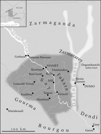
The Fulɓe, while generally both farming and raising livestock, self-identify as livestock-rearing people. Despite this identification, Fulɓe society is complex, with not all Fulɓe actively involved in herding (Kintz Reference Kintz1985), the livelihood activity that is the focus of this article.Footnote 4 Historical centres of Fulɓe concentration in the study area were south-west of the river and along its eastern edge in the Dallol Bosso (Figure 1), a fossil river valley (with a higher water table) which is also known as the Dallol Boboye. The area south-west of the Niger River in what is now the Say Department is historically an area of political refuge, lying between a succession of political powers of the Songhai Empire to the north-west; Sokoto Caliphate to the south-east; and Zarmaganda and the Kel Tamashek nomads to the north. Its geographical location explains its role as a refuge: it was protected to the north and east by the Niger River and to the south by what has been called a ‘no man's land’ (Benoit Reference Benoit1999) lying north of the Bourgou (Bariba) and north-east of the Gourma, the centre of the loose confederation of Gourmantche people. Waves of different Fulɓe clans moved into the area, largely from the west, starting by at least the eighteenth century (Loyance Reference Loyance1947; Hama Reference Hama1968; Laya Reference Laya1991). Immigration to the area intensified with the growing influence of Mohaman Diobo during the early nineteenth century: Diobo established Say as a religious and economic centre (Lem Reference Lem1943). It was during the relatively brief period of Diobo's power (1816–50) that the area experienced a short-lived period of security relative to the centuries of unrest and uncertainty that preceded it.
The study area (shaded) as located within current national boundaries (dashed lines). Towns and villages mentioned in the text are displayed. The location of the study area in relation to the precolonial empires of Songhai and Sokoto Caliphate is shown in the map inset. The other historical areas of the Gourma, Bourgou, Dendi, Zarmaganda and Zarmatarey are shown. The region within the study area lying south-west of the Niger River (rive gourma) is referred to as the Say area while the area lying north-east of the Niger River is the Fakara (defined as the area lying between the Niger River and the fossil river valley called the Dallol Bosso).

Fulɓe groups varied in how they gained land and rights to settle in the area. Some, like the Bitinkooɓe, fought with the groups that they found there (such as the Gourmantche). Lem (Reference Lem1943: 66) and Karimou (Reference Karimou1977: 116–18) describe the more typical pattern of small groups of Fulɓe immigrants asking permission to settle alongside existing farming populations, where they slowly gained power and influence by providing much-needed services to resident agriculturalists. By providing manure and milk as well as herding and political mediation services, they ingratiated themselves with the original clearers of the land. This account, while describing historic, less violent, patterns of Fulɓe settlement south-west of the river, is consistent with most Fulɓe immigration into the historic strongholds of the Djerma (Zarmatarey and Zarmaganda) to the north of the river as well. In these cases, Fulɓe did not gain land rights upon settlement – these remained in the hands of Djerma chieftaincies. Village chiefs in these areas are the descendants of those who cleared fields and first dug the wells that allowed year-long human settlement.
Reports are few but there is evidence of close social and economic connections developing among Fulɓe herders and sedentary Fulɓe, Djerma and Hausa farmers, artisans and village-based nobles. Kimba (Reference Kimba1981: 27) argues that there was considerable interest among all ethnic groups and social classes not only in farming but also in raising livestock, hunting and fishing. There are reports of contracts governing the herding of others’ livestock (particularly cattle) by pastoral Fulɓe (Lem Reference Lem1943: 66) and, especially north of river in lands controlled by the Djerma, the loaning by village chiefs of land to Fulɓe to farm. This is consistent with the current prevalence of herding contracts (Habou and Danguioua Reference Habou and Danguioua1991) and the continued control of agricultural land by village chieftaincies (Heasley and Delehanty Reference Heasley and Delehanty1995). In this way, the herding Fulɓe are best seen as the managers of the livestock wealth of the area, with variable rights to cultivatable land (strongest south-west of the river).
Livestock during the nineteenth century were largely managed by herders in open pastures – as most are now (Diop et al. Reference Diop, Cesaro, Touré, Ickowicz, Toutain, Touré, Ickowicz, Wane, Garba and Gerber2012). Then as now, biophysical conditions in the region most likely encouraged seasonal north–south movements across long distances (200–300 kilometres) to take advantage of the sparser but more nutritious forage in the north during the rainy season and the greater availability of water and the earlier end of the dry season (e.g. initial greening of vegetation) to the south. At the same time, there was a need at any given latitude to move in a flexible manner in response to the shifting availability of forage and water. Given the lower cropping pressure in the region compared with today, conditions in the nineteenth century were probably more supportive of these flexible, shorter-range movements. Longer-distance herd movements were another matter. Since livestock could easily be stolen, regular transhumance movements were limited during periods of insecurity (Bonfiglioli Reference Bonfiglioli1988). For example, Ba and Daget (Reference Ba and Daget1984) describe transhumance herds being accompanied by cavalry to ensure their safety in the Maasina Empire of central Mali in the nineteenth century. Another difference is that there was likely a greater reliance on floodplain pastures during the dry season than today, particularly by Fulɓe pastoralists. Descriptions of pastoralist movements in Senegal, Mali and Niger support this (Bonnet-Dupeyron Reference Bonnet-Dupeyron1951; Gallais Reference Gallais1967; Reference Gallais1975; Beauvilain Reference Beauvilain1977; Santoir Reference Santoir1979), as does the distribution of Fulɓe populations in the mid-twentieth century (Stenning Reference Stenning, Ottenberg and Ottenberg1960: 144–5).
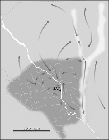
Within the study area, current descriptions of livestock movements for grazing show resident herds along the right bank of the river (Say) moving south during the late dry season into Burkina Faso or Benin (Wilson Reference Wilson1984; de Haan et al. Reference de Haan, van Driel and Kruihof1990; Rouher and Styblin Reference Rouher and Styblin1993; Benoit Reference Benoit1999; Turner Reference Turner1999; Bassett and Turner Reference Bassett and Turner2007). On the left bank of the Niger River, they move north (during the rainy season) and south (during the dry season) within and along the Dallol Bosso (Doutressoulle Reference Doutressoulle1924; Beauvilain Reference Beauvilain1977; Beidi Reference Beidi1993). Descriptions of livestock movements, along with oral histories collected from key informants in the area, point to quite different types of herd mobility on either side of the river during the precolonial and early colonial periods (Figure 2). To the north and east of the river (left bank), seasonal movements more likely followed the classic long-distance movement to the north during the rainy season and south to the floodplain of the Niger River and along the Dallol Bosso (Doutressoulle Reference Doutressoulle1924; Beauvilain Reference Beauvilain1977). Along the right bank, south and west of the river (Say), longer-distance movements were not common despite the fact that the area was described as one of the most important centres of livestock husbandry in the region (Doutressoulle Reference Doutressoulle1924: 53). Herds were inhibited from moving north into the Zarmaganda and Zarmatarey, not only because of the physical barrier posed by the Niger River but also because of security concerns – these Djerma polities did not provide protection to Fulɓe herds from raiding, particularly by the Kel Tamashek. Prevalence of the tsetse fly inhibited movements to the south (Roubaud Reference Roubaud1913).Footnote 5 Instead, herds moved within a shorter radius from a family's village, with some orientation towards the Niger floodplain and its tributaries during the dry season.Footnote 6
Major axes of seasonal herd movements (for pasture) prior to and during the study period as reconstructed from historical accounts cited in the text.

Oral histories collected on the right bank of the river also note that livestock movements during this time were strongly affected by the general insecurity of the area, with herders often required to stay away from home villages (but within relatively close proximity) in the bush and constantly moving to avoid raids. Rouher and Styblin (Reference Rouher and Styblin1993) also raise this point, noting that it was only during the time of Mohaman Diobo that conditions were conducive for long-range transhumance on the right bank. Shorter-distance movements to and from the floodplain were facilitated by reciprocal alliances between local groups. This was undoubtedly the case along the left bank as well.
By all accounts, livestock trade during the precolonial period, while active, was local rather than regional (Kervan Reference Kervan1992; Quarles van Ufford Reference Quarles van Ufford1999). Livestock were not a major part of the caravan trade that often passed through Say, an important trading point and river crossing at the time. Hausa traders are reported to have trekked livestock from Sokoto to Asante territory (in present-day Ghana), with the most northern trek of this trade operating through Say (Quarles van Ufford Reference Quarles van Ufford1999: 68). However, regional trekking of livestock most likely represented a small fraction of the livestock trade during the precolonial period.
The imposition of colonial rule
Mohaman Diobo died in 1836 and five of his sons subsequently served as successors prior to the establishment of French rule in 1891 (Lem Reference Lem1943: 75). During the second half of the nineteenth century, the study area experienced a significant decline in political stability and cohesion and an expansion of internal warfare along with incursions of Djerma and Kel Tamashek from the north. Reflecting this, the city of Say declined as a major centre of economic activity (Karimou Reference Karimou1977: 147; Fugelstad Reference Fugelstad1983: 39–41). Early French visitors describe significant war-related damage to the town of Say itself (Baillaud Reference Baillaud1900: 21); significant disruption of livelihoods due to fear (Karimou Reference Karimou1977: 147); and depopulation and village abandonment along the river south of Say (Hourst Reference Hourst1898: 380; Lenfant Reference Lenfant1903: 167). Added to this turmoil was the outbreak of rinderpest in 1890–92. Lieutenant Colonel Monteil, who visited Say in 1891 to first establish it as a protectorate of French Soudan (followed by two other competing protectorates with Haute Dahomey in 1895–96), noted the decimation of livestock herds in the region, observing that mortality was highest among sedentary herds (Bonfiglioli Reference Bonfiglioli1988: 97). Bonfiglioli (ibid.: 97) reports that this created significant changes in the mobility of livestock herds in the region: those who lost most of their livestock managed their remaining herds in a sedentary fashion while those who had escaped significant losses pursued strategies of high herd mobility even if they had previously managed their herds in a more sedentary manner.
From 1890 onwards, Say was a key geographical location in the competition between the French and the British (Newbury Reference Newbury1959; Moatti Reference Moatti1984). Say served as the eastern point of the provisional demarcation between French and English interests as laid out by the Franco-Anglo accord of 1890. French missions from Dahomey pushed north, attempting to reach the Niger River, while other French pushed east from the French Soudan, resulting in multiple treaties being signed between these two separate French colonies and the Say chief (Obichere Reference Obichere1971). The administrative post of Say was established in 1897 (Lem Reference Lem1943: 63). As the easternmost French colonial post, Say figured prominently in the negotiations between not only the two French colonies but also with British Nigeria. The boundaries between these colonies were reworked throughout the 1890–1910 period (Ganier Reference Ganier1962; Thom Reference Thom1971; Fourage Reference Fourage1986).Footnote 7 The political calculus of French rule at the time is captured by this closing statement of a 1897 letter written by the commander of the Say post:
The chiefs have adopted a wait-and-see attitude, they are studying our conduct with regard to Say, if they perceive weakness on our part, they will unite to bring us down. If, on the other hand, we deal harshly with them they will become fearful and leave our territory.
Therefore we must follow a strategy of restraint and patience but it is also necessary that the hand that rules, while gloved in velvet, is firm – one who rules must have much perseverance.Footnote 8
Up until 1911, the French relied on a type of indirect rule – granting authority to those customary authorities that would best serve their interests (Bonfiglioli Reference Bonfiglioli1988: 89). Slavery was very prevalent in the area, with slaves (of different types) constituting an estimated 75 per cent of the Say population at the onset of French rule (Kimba Reference Kimba1981: 27). In the famous circular of June 1906, the Governor of the Upper Senegal and Niger Colony proclaimed the incompatibility of slavery with French rule (Fugelstad Reference Fugelstad1983: 68). While one can easily overestimate the speed at which the institution of slavery declined, Fugelstad (ibid.: 68) reports that many slaves quickly left their masters. Slave emancipation and interest in escaping colonial rule led to the dispersal (particularly southward) of the rural population in the area south and west of the river (Institute de Recherche en Sciences Humaines 1977; Amadou Reference Amadou1991).
Livestock and taxation
French administrators in Niger faced a difficult situation. They were expected to generate revenue to support their activities – which were considerable at Say, given the numerous colonnes (military columns) that embarked from Say eastward to establish a French presence along the ill-defined boundary with the British (including the infamous Voulet-Chanoine column that left Say in 1899). At the same time, they ruled over a relatively dry, unproductive region (compared with that under British control) that was sparsely populated by often mobile people. Livestock figured prominently in colonial assessments of economic prospects and extractable wealth in the large area they found themselves administering after the scramble:
With the exception of the valley of Niger River and the banks of the Komadougou [flowing into Lake Chad], the colony of Niger is very poor. This poverty is due to the low density, and, one must say, the laziness and improvidence of its population, combined with the mediocre climatic and commercial conditions. Economic development possibilities appear very limited except along the middle Niger. Everywhere else, natural or industrial products are limited by the prohibitive costs of transport – a single element, livestock, escapes this rule, since it constitutes a commodity that can transport itself and whose sale is largely assured towards southern Nigeria where the population is high but lacks animals. Therefore, pastures seem to be the unique ‘udder’ of the colony across nine-tenths of its surface area. (Abadie Reference Abadie1927: 174)
Livestock and grain were commonly requisitioned from rural communities to supply both colonial posts such as Say and colonial military columns as they moved through rural areas.Footnote 9 The area around Say, already in a fragile economic condition due to warfare and rinderpest, is reported to have experienced significant economic disruption from these early requisitions (Lem Reference Lem1943; Kimba Reference Kimba1981: 124–5). More regular forms of taxation began in 1898 in Say, and in more outlying areas in 1899, with the institution of head taxes. Censuses of both population and livestock wealth formed the basis for tax revenue expected from village chiefs. Kimba (Reference Kimba1981: 108) quotes a June 1902 report prepared by the Dosso post commanderFootnote 10 showing the difficulties encountered when doing a census of village populations as well as the French interest in livestock ownership:
The Djermas seem to regard the French with fear and their fear pushes them to alter the truth. Therefore, during the censuses, no precise information is provided by the natives. They invariably respond that they own nothing … When asked about the numerous footprints of animals, they respond that they were made by animals of neighbouring villages coming to be watered at their well – naturally, at the village mentioned, one obtains the same response. They are convinced that we intend to take their wealth. Our patient explanations seemed to be understood but they [the Djermas] are not convinced.
Initially, these taxes could be provided in kind (grain, livestock, cloth or currency), but by 1906 only French currency or cowries were accepted, and by 1910 only payments in francs were allowed throughout the territory (Painter Reference Painter, Cordell and Gregory1994). French currency was often in short supply and livestock proved important as they could more easily be sold than grain to obtain francs. Particularly during drought or locust infestation periods (such as 1901–03), people often requested to pay their taxes in the form of livestock, their major form of remaining wealth, due to the exhaustion of granaries stemming from crop failures (Kimba Reference Kimba1981: 106). Additional market taxes on livestock (ibid.: 126) and transit taxes on trans-Saharan caravans (Kervan Reference Kervan1992: 78) were added in 1902 and 1903 respectively.
Each year, a major preoccupation of French administrators was the villages that had failed to pay their taxes after harvest. During the dry season, administrators would go on tour in the bush and visit delinquent villages and use various techniques to elicit payment. For example, a February 1899 political reportFootnote 11 from the Say Residence notes:
At Lamordé, a village of Torodi not able to provide the millet stipulated (because there was none), Moussa the village chief was stripped of his gris-gris [amulets] and tied with hands behind his back for two days. In the end, the village provided their fine of 23 cattle [for not paying taxes], an enormous amount for a single village.
Payments and fines collected in this way were often in the form of livestock for a number of reasons. First, tax delinquency was most prevalent with the failure of harvests. Thus, payments in grain were not possible due to the fact that village granaries were empty (as acknowledged in the quote above). Livestock, as the major store of wealth held by rural peoples (other than slaves), were often what could be paid – until these wealth stores had been exhausted. In addition, livestock served as a resource that was not only of interest to the French but could also be extracted relatively easily and moved (on the hoof) from villages.
The drive for tax revenue, in the form of livestock, intensified the competition between the colonial administrators of the North-East Region and Dahomey along the ill-defined boundary that lay between these two sets of French interests. A confidential letter dated 3 January 1900, written by the Commander of the North-East Region of French Soudan, summarized one of the disputes leading to a significant political conflict with the Dahomey colony in this way:Footnote 12
Near the end of June [1899], Dahomey troops captured a herd of 187 head in the village of Sanayouri, a dependency of Koulbou. From there, a complaint from the [cattle] owners was sent via the Residency of Say to the chief of the Matiacouly [Matiakouali] post. The chief of the Matiacouly post responded that the village of Sanayouri belonged to Dahomey and that the cattle were taken as tax, this village having refused to pay its contributions. The plaintiffs, carrying a letter from the Say Resident, travelled to Matiacouly and were imprisoned.
Koulbou had always paid its tax to Soudan. As evidence, one finds, in consulting the regional archives, that: 1. In March 1898, the son of the Koulbou chief was imprisoned by Lieutenant Delaunay for refusing to pay tax; and 2. The village was burned for this reason in April 1898 by Captain Dubreuil and again in February 1899 by Commander Diagie. A letter written with the above-cited evidence on 24 August [1899] to the Commander of the Middle Niger [of Dahomey] by the Commander of the North-East Region, demanding that the prisoners and herd be released, did not receive any response.
It is interesting that the evidence used to claim that the village and herd in question were under the jurisdiction of the Say Residence (and the North-East Region of Soudan) was that the village was burned twice by the Say administration. Still, what is most important here is that a single cattle herd was seen as important enough to lead to significant discord, at a very early stage, between two French colonial interests holding uncertain territorial claims.
Changes in livestock mobility with the imposition of colonial rule
There is little documentation about changes in livestock grazing movements with the imposition of colonial rule. Still, one can develop a tentative reconstruction of dominant grazing movements during the study period by combining what is known about precolonial movements (described above) with admittedly limited information about responses to rinderpest and French requisitions of livestock by Fulɓe herders at the time (Figure 2). Informants in the Say area emphasize how the waves of rinderpest sweeping through the area during the study period affected livestock mobility, with every effort made by herders to stay away from contaminated places and other livestock herds. Moreover, the French preference for requisitioning livestock at villages that were delinquent in paying their head taxes provided an additional incentive for livestock to be managed away from villages in the bush. Therefore, one can reasonably presume that the pattern of grazing movements in the Say area during the immediate precolonial period – high-frequency but shorter movements away from villages – continued and expanded during the study period. Say informants point to this period as one in which livestock herds very rarely stayed in villages for any length of time, which led to a disruption in the villagers’ access to milk. In addition, movements during the dry season to floodplain pastures may have declined in certain areas due to the increased presence of French troops along the river. For the Fulɓe on the left bank of the river, French rule may have spurred seasonal movements to the north by herders keen to escape colonial requisitions closer to the river (Bonfiglioli Reference Bonfiglioli1988).
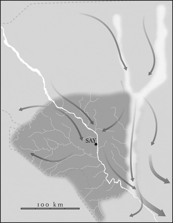
During the early colonial period, demand for livestock increased dramatically in the regions south of the study area, due to the combination of economic development and consumptive demands by Europeans. As a result, there is evidence of the trekking of livestock from the study area towards these expanding markets.Footnote 13 As shown in Figure 3, most of these movements were located to the north-east of the Niger River – along the left bank of the river itself or along the Dallol Bosso. During the dry season, these trekking herds most likely encountered transhumance herds moving to river pastures and south along the Dallol Bosso (Figure 2).
Major axes of livestock trekking to markets during the study period as reconstructed from historical accounts cited in the text. The width of the arrows reflects the relative volume of livestock moved.

Taxation and the movements of people and livestock
Heavy taxation, low crop prices and drought contributed to a flow of people and livestock out of the Niger colony. Painter (Reference Painter1988: 93) reports that, in 1903 alone, an estimated 10,000 people left South-Western Niger, primarily to Nigeria. The movement by people within and outside French colonial boundaries was an important strategy to escape French taxation. The Wodaaɓe, a highly mobile pastoral group who moved along the eastern edge of the study area (along the Dallols), were generally able to escape taxation (Bonfiglioli Reference Bonfiglioli1988: 95). This was worrisome to the French, who began to understand the limitations of a territorial state that was dependent on its mobile subjects for support. For example, a November 1902 political reportFootnote 14 mentions the interception of a number of groups of Fulɓe with their herds:
Emigration has reached disturbing levels during the month of November. A group of Kourteyes [from the village of Kourteye] from the Sansanne Haoussa [Hausa] canton with seventy-one head of cattle was surprised in the Fakara while headed for Sokoto … A group of thirty-two Seetanga Fulɓe, heading for Kollo, crossed the district near Bunelera. Four were stopped, the others fled when the group was confronted … Two herds of thirty head of questionable origin were seized in Gaya. The detained emigrants state that the misery in their home region caused by drought has pushed them to seek to move south temporarily where life is easier and the soil more fertile. The tax question was not uninfluential in their decision to leave … It therefore seems necessary to reduce the tax in order to retain river populations within our authority since to the south the tax is much less and the soil more rich.
At least one of the intercepted groups (from Seetanga) might have been moving along its seasonal transhumance routes rather than seeking to leave the colony.Footnote 15 However, this report points to the concern that higher French taxes might be causing a loss of people and livestock to the British. The French–British contrast reflects in part the greater intensity and reach of French compared with British administration in the area on its side of the border during this period (Thom Reference Thom1971: 137). For the French, this was its relatively well-watered southern portion of the colony unperturbed by the Kel Tamashek insurrection. The British, in contrast, had very little administrative presence in Hausaland. Still, the British recognized the benefits of people and animals moving across the border from Niger. Lord Lugard, as quoted by Thom (ibid.: 134), stated in a letter to the Colonial Office on 3 January 1903:
I shall of course do my best to encourage this immigration for this Protectorate has been terribly desolated and its population decimated in recent years by internal wars and the slave raids of the Fulani etc. The advent of fresh inhabitants possessed of flocks and herds will mean an added source of wealth to the British territory and impoverish the French.
The French attempted to restrict the movement of livestock south across the border in 1914 but abandoned this policy in 1918 since ‘the costs of maintenance exceeded the receipts of duties and tariff’ (Kervan Reference Kervan1992: 79). The French administrators of Niger had failed to directly control the movement of livestock and people across the southern border. Thus, throughout the period, the French and British were in a continual competition for people and livestock, largely through their tax policies. Accordingly, we see a constant adjustment of the head tax by the French to maximize revenue while attempting to keep people in place within their colonial boundaries.Footnote 16
The archival record provides little evidence that French administrators understood the full motivation for livestock movements. Despite their view that livestock movements in a southerly direction were largely to avoid taxation and therefore cause for alarm, there were undoubtedly other reasons for the observed movements. First, as described earlier, seasonal north–south movements along the Dallol Bosso were parts of a well-established transhumance pattern (Figure 2). Thus, French on tour during the dry season might encounter herds whose movement south was in search of pasture rather than driven by an impulse to permanently leave the territory. Second, although there was an increase in southerly trekking of herders to sell livestock during this period, these herders were more likely to have been returning home with the proceeds of their sales than leaving French territory definitively.
The French preoccupation with the movement of livestock and people (transhumance, trekking and departures) played a role in the location of their military posts. While a residence in Say was maintained, administrative authority was increasingly shifted across the river (first to Niamey and then to Dosso) to better monitor and attempt to control livestock movements along the left bank, which, as displayed in Figures 2 and 3, were inherently longer-distance movements eliciting greater colonial concerns of loss.Footnote 17
Livestock movements and the limits of the territorial state
Not only did an understanding of the rationale for Fulɓe-managed herd movements prove elusive, but the colonial administrators’ ability to monitor and control these movements was limited. For example, the French attempted to regulate the movements of livestock across administrative boundaries by the requirement of passes soon after establishing the post at Say.Footnote 18 But few people sought to obtain these passes. The requirement served little purpose beyond allowing colonial officials to apprehend herds for unauthorized movement.
The extent of livestock movements and the limits of colonial power to limit them are revealed by rinderpest and its control. From 1890 to 1920, rinderpest proved to be a recurrent problem throughout the study area. Colonial studies of its spread demonstrate the importance of the study area as a key point of passage in the regional spread of the disease, despite significant colonial efforts there to control livestock movements. Aldigé (Reference Aldigé1918), reporting on the spread of rinderpest into and through the study area in 1915–16, traces it from Gaya (see Figure 1) along both banks of the Niger River, into northern Dahomey within two months, and eventually into Say, three months later, despite a quarantine. It finally spread, a year later, to what is now Western Burkina Faso and Mali, despite a double quarantine line around Niamey and Say districts.Footnote 19 In a summary of the geography of rinderpest up until the 1920s, Malfroy (Reference Malfroy1923: 221) points to the study area as an important dispersal point in the regional westward spread of the disease, stating: ‘From the Niamey cercle, they [the epizootics] spread to Dahomey, Upper Volta, Soudan and from there to Guinea, Ivory Coast, Senegal and Mauritania.’
As detailed above, French administrators were not concerned with livestock movements simply from a veterinarian perspective. Economic considerations played an equally large role, since livestock were the major store of wealth in the Military Territory of Niger. Despite these strong interests, their ability to keep livestock herds within their colonial boundaries was extremely limited. This led to significant levels of colonial anxiety and efforts to apprehend herds on the move. Sometimes these efforts led to diplomatic problems. To illustrate this, we return to a second incident of 1899 that contributed, along with the first described above, to the early conflict between the Military Territory of the North-East and Dahomey. The incident is described in a confidential letter from the Commander of the Military Territory of the North-East dated 3 January 1900 (see Figure 1):Footnote 20
Some natives, without a pass, tried to bring a herd to the Dahomey territory. The Resident of Say gave the order to two political agents and a military detachment to capture them at Kollo and to bring them to Say. The native non-commissioned officer who commanded this regiment, not finding those that he was looking for at Kollo, chased them as far as Kirtachi and, thanks to the help of that village's chief, was able to bring back the herd to Say with the herders fleeing. The Resident of Say punished the native non-commissioned officer, culpable of penetrating without orders into the territory of Dahomey (18 March). Several days later (27 May), Captain Lesol, Commander of the Middle Niger (Dahomey), demanded that this non-commissioned officer return with the seized herd to Kirtachi so that he could return it to its owner, who had moved to Kirtachi two years earlier.
A discourteous correspondence ensued. The Commander of the Middle Niger visited Kirtachi to conduct a study and confirmed that a certain Mamadou, the owner of the herd, had moved to Kirtachi two years earlier and therefore the herd needed to be returned. But a contradictory study was performed by the Resident of Say, finding that the real owner was the brother of this Mamadou, named Oumarou, who still lives in Banaguiti of the Say Residence.
After all this, the Commander of the Region NE wrote on 25 August to the Commander of the Middle Niger that while, in principle, the herd should be returned to Dahomey, a recognition that this herd really belongs to an inhabitant of Soudan requires that the herd be returned to the real owner [Oumarou] and offers to do so on behalf of Commander of the Middle Niger [Dahomey]. This letter never received a response.
This incident reveals the difficulty of enforcing territorial boundaries in a setting where subjects (humans and livestock) are highly mobile. In principle, the Commander of the North-East Region recognized that the herd in question was apprehended within the territory of Dahomey. However, he made the claim that, despite the location of the herd and its manager (Mamadou) when apprehended, the real owner lived near Say and therefore the livestock rightfully should remain there. Colonial administrators, whose titles were clearly tied to particular territorial units, found themselves making claims over people and their property rather than solely over territory, similar to the governance claims of precolonial states that were more concerned with control over people than territory per se (Coquery-Vidrovitch Reference Coquery-Vidrovitch1988).
Competition for livestock and their managers
As described above, the Fulɓe were the major managers of livestock wealth within what is now South-Western Niger, despite the fact that others may have owned the livestock they herded. Colonial government policy increasingly became centred on keeping not only people but livestock wealth within territorial boundaries. This led to a kind of ethnic accounting of the comings and goings of people by colonial administrators. In a 1903 political report,Footnote 21 the administration describes the loss of people from the village of Maouri due to high taxation but concludes with this statement:
Some Fulɓe have returned with very important herds. We have gained more on this side than we have lost with respect to the potential population loss in Maouri where the inhabitants are cultivators.
In this way, the gain of Fulɓe (with their livestock) by the colony is seen as outweighing in importance its loss of cultivators (for example, Hausa, Djerma and Maouri). We could view this as creating a situation in which the coercive power of the colonial state would be focused on controlling the movements of the Fulɓe. But this ignores the limits of territorial state power to monitor and regulate the movements of mobile peoples. The colonial state's approach could be seen as more one of negotiation in this case – using both sticks and carrots. In a 1902 political report,Footnote 22 the Commander of the Third Military District provides the rationale for why Fulɓe with their herds should be allowed to establish separate villages, thereby claiming land ownership from Djerma chieftaincies, stating:
A group of Bairo Fulɓe from the Dallol Bosso is emigrating to Sokoto. To prevent this growing trend which takes high-quality herds from us, it has been decided that the Fulɓe and Djerma villages should be separated from each other with respect to governance and in those cases where the Fulɓe and Djerma live together in the same village, a separate tax for each group should be established. For those who are caught leaving, a portion of their herds should be confiscated.
This decision to give political autonomy to the Fulɓe from Djerma village chiefs (Beauvilain Reference Beauvilain1977: 56; Kimba Reference Kimba1981: 124) did more than change the nature of tax collection,Footnote 23 since, by creating new independent villages, the agropastoral Fulɓe gained much more secure rights to the land they farmed. This explains the fact that villages of ‘X Peul’ paired with ‘X Zarma’ or ‘X’ or ‘X Hausa’, while rare in Niger, are not uncommon within the study area.Footnote 24 Although they were threatened with confiscation of their herds, the Fulɓe did gain an enduring benefit of land rights due to the colonial administration's aim of countering their proclivity to move with their livestock.
Discussion
The major extractable store of wealth held by rural people living in dryland West Africa was livestock – and to a large extent still is. Due to its unique geographic position, the study area experienced very heavy extraction of rural wealth to support the ambitious expansionist plans of the French. As shown here, early colonial rule focused much of its effort on the collection of taxes and requisitions, with the latter often obtained in the form of livestock. These extractions were often associated with violence as the French attempted to count, monitor and tax a mobile people holding livestock wealth in multiple shifting locations.
This case raises some interesting questions about the early formation of the territorial colony in West Africa. The building of borders between French and British possessions created demands for revenue to militarily subdue rural populations in order to claim territory. However, at the same time it created colonial anxieties about the loss of the source of that income (people and livestock), since, once borders were established, colonial subjects could move across them. This revealed a weakness in the territorial state model for settings where resources are sparse and subjects are mobile. There was nothing tying people to particular places. To hold people within their territorial containers, French administrators, unable to police their borders, instead focused on the movements of people and livestock within their borders, since such movements could extend across the border and could possibly result in the permanent loss of people or livestock wealth from the colony. While the border served as a major focus of competition between colonies, colonial administrations – like those of precolonial empires – sought to control people whose movements often ignored or strategically responded to colonial borders.
We can think of the actions of livestock herders and of French administrators as highly interactive, each responding to the other – a sort of negotiation without face-to-face interaction. These negotiations helped shape colonial governance in the borderlands of what is now South-Western Niger. Consistent with the framework of borderland studies, the exact location of the borders with Dahomey and Nigeria were not critical in affecting these negotiations. In fact, these borders shifted throughout the period and were poorly defined on the ground. The fact that borders were proximate and therefore traversable shaped Fulɓe–administration negotiations.
Evidence for the French being party to negotiations with Fulɓe herders, as defined above, is clear. The level of attention paid to the actions of even quite small Fulɓe herds is remarkable. This attention is evidenced not only by reports of any sighting of herd movements but also by the diplomatic debates about ownership of livestock (Mamadou or his brother Oumarou) moving across what was at the time the ill-defined boundary between Dahomey and the North-East Territory (Niger). This attention reflects the importance of livestock as the major store of extractable wealth (through requisitions stemming from tax delinquency) within the poor and arid region under their purview. The French often misinterpreted the reasons for herd movements; they were quick to interpret these herd movements as attempted escapes from their authority when intercepted herders were just as likely leading livestock to seasonal pastures or markets. Still, the French reacted to herder actions, seeking not only to improve their surveillance of herd movements but also to make the colony more attractive to the Fulɓe – the managers of their colony's wealth. To improve their surveillance abilities, the French sought to establish more of a presence along the left bank of the Niger River, where long-distance movements of livestock (with people) were most prevalent (Figures 2 and 3). The French shifted their administrative posts to the left bank of the Niger, with Say declining as an administrative centre relative to the new posts of Niamey (previously a small fishing village) and Dosso on the left bank. French administrators sought to keep their subjects within the area's boundaries not only by recurrent recalibration of head taxes (relative to those of the British), which affected the household economies of all ethnic groups, but also by displaying a particular interest in retaining the Fulɓe compared with other groups. In a major move, the French gave tax collection authority to local Fulɓe leaders, endowing them with a level of political autonomy not enjoyed previously in the areas north and east of the river (Zarmaganda and Zarmatarey). In some cases, Fulɓe hamlets tied to Djerma villages were given independent chieftaincy status and, along with it, greater rights to land. In these ways, efforts to monitor and retain Fulɓe in their territory had an enduring effect on the geography of South-Western Niger – not by influencing the boundaries dividing Benin, Niger and Nigeria but through their effect on the size and status of various towns and villages. Improved monitoring of Fulɓe herds was part of the impetus for the construction of the French fort at Niamey (now the capital city of Niger) and was the major reason for the creation of independent Fulɓe villages in Zarmaganda and Zarmatarey.
Explicit evidence for Fulɓe herders being involved in negotiation, as defined above, with French administrators is less easy to find. All written accounts from the time were written by French administrators. Testimony from local informants today does not provide specific information about particular incidents or social interactions. But informants do point to herders’ determination to avoid the French as much as possible, given that livestock were requisitioned for tax delinquency. There is ample evidence from colonial reports of the time of this strategy. Fulɓe herders, when encountering French troops, were quick to flee, and pursuit often required considerable time and effort. For example, in the case of the herd of Mamadou and Oumarou, Mamadou was pursued by the native non-commissioned officer for some 70 kilometres between Kollo and Kirtachi over difficult terrain. This case also provides some evidence for Fulɓe manipulation of the French. Livestock within single herds are often owned by multiple people: a herd, for example, might be jointly managed by two brothers. Therefore, the claim by Mamadou that the herd was for his brother Oumarou might have been partially accurate in that the ultimate management authority may have been held by his brother. The French interpretation of his statement that Oumarou was the owner of the livestock within the herd probably grossly simplified the distribution of livestock ownership. However, this interpretation would have supported the Say Resident's claim on the herd while lessening the concern that Mamadou intended to permanently leave his jurisdiction with the livestock. The outcome of Mamadou's capture was confusion among French administrators and a diplomatic crisis between Soudan and Dahomey, not over the location of their mutual border per se but over the ownership of a herd of cows. Although Mamadou's sentiments are lost to history, his statements, in what they revealed and hid, likely played a key role in the herder–administration ‘negotiation’ that led to the diplomatic crisis.
Conclusion
In conclusion, the French sought to impose territorial control over their human subjects at the onset of colonial rule. Their acts of governance were made while scrutinizing and reacting to the movements of herders and their livestock. Thus, we can think of French governance as the outcome of a hands-off negotiation with the managers of colonial wealth. French political reports are dominated by references to the movement of people and livestock between points. Their political geography centred on maintaining control over people and livestock classified as residents of points (villages) that were categorized as being within their jurisdiction. Interestingly, their acts of governance necessarily operated through a perspective that echoed the point-centred geographies of tenure and management held by the pastoralists they were chasing (Moritz et al. Reference Moritz, Scholte, Hamilton and Kari2013; Turner et al. Reference Turner, McPeak and Ayantunde2014; Cormack Reference Cormack2016).Footnote 25 The day-to-day acts of monitoring, taxation and coercion conducted by the French in the borderland were less about the border itself and more about the control of mobile people and livestock.
This historical period provides useful insights into the governance implications of livestock mobility in contemporary semi-arid West Africa. While livestock mobility is now recognized as an important response to climate change, the tensions between livestock mobility and territorial state are clear (Tonah Reference Tonah2000; Bassett Reference Bassett1988). The limitations of the territorial model for governing livestock mobility in colonial Africa remain today. Territorial boundaries that are the premise not only of the modern state but of common property theory have failed to effectively manage these movements in order to achieve social or ecological goals (Moritz et al. Reference Moritz, Scholte, Hamilton and Kari2013). Arguably, flexible responses to changing resource distributions through livestock mobility are facilitated through networks of point features that transcend subnational and national boundaries (Turner et al. Reference Turner, McPeak, Gillin, Kitchell and Kimambo2016). Although the political context has changed, there remains the need to address the disjuncture between the attributes of territorial governance and the requirements of livelihood responses to climate variability and change.