Introduction
On 5 February 1821 two early Antarctic explorers, the 42-year-old Captain Faddei Faddeyevich Bellingshausen of the Imperial Russian Navy, and the 21-year-old American sealer Nathaniel Brown Palmer, master of the 44.5 ton sealing sloop Hero, met briefly off the South Shetland Islands. (All unqualified dates in this note, such as that in the previous sentence, are New Style (Gregorian calendar). Dates in the Old Style (Julian calendar) are designated ‘O.S.’.) Through telling and retelling over the next 100 years the event acquired a historical aura similar to that which surrounds the breakfast shared by Flinders and Baudin at Encounter Bay, South Australia, in April 1803. But the meeting of the two men on board Bellingshausen's HIMS Vostok was subject to misunderstandings and misstatements for a long time before being scrupulously re-examined by Bertrand over forty years ago (1971: 77–79). Bertrand found largely in favour of Bellingshausen's account of the meeting without seeing all the available evidence, especially on the Russian side. In the same spirit, this note seeks to determine what is certain and what can reasonably be supposed about the meeting without revisiting the vexatious priority dispute that brought so much attention to it in the twentieth century.
Factually unreliable parts of cited texts have been marked as follows. Items which are certainly inaccurate are shown with solid, and items which are possibly inaccurate with dotted underlining. Other parts of the texts which may also be problematic are identified in the discussion.
The Russian version
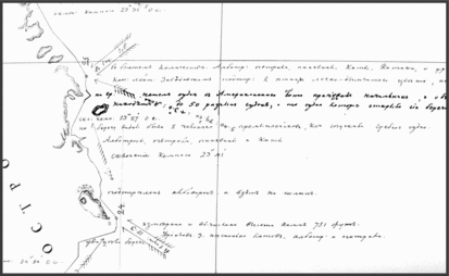
There is no entry for 5 February 1821 in the logbook of Hero, and no Russian logbooks or officers’ journals have survived from the Bellingshausen voyage. The earliest surviving record of the meeting, therefore, is one of Bellingshausen's annotations for the morning of that day on a 15-sheet track chart which he prepared a few months later, during his return voyage from Rio de Janeiro to Kronstadt. It was entered opposite a kink in Vostok's track near the eastern end of the strait between Livingston and Deception Islands (Fig. 1), and reads as follows:
Part of Bellingshausen's track chart at the South Shetland Islands, with north to the left. Smith Island at the bottom left is followed by Snow, Livingston, Deception, Greenwich, Robert, Nelson and King George Islands in ascending order, with few details of the straits between them. The entry for the meeting with Palmer near Livingston Island is picked out in bold (Belov, Reference Belov1963: Sheet 14, detail).

The skipper of an American boat came across on our rowing boat and stated that there were up to 50 different ships there for the seal hunt. The ship that had discovered the place had slaughtered more than 60 thousand seals (Belov Reference Belov1963: sheet 14).
The conditions recorded on Bellingshausen's chart for noon, about an hour after Palmer returned to Hero, were clear, with a fresh wind (about force 4) from SWbS and a weak current (1.8 knots) trending northwest. There was no reference to fog for that day, but murk or fog had been noted along the shore (nad beregom) at noon on the preceding day, shortly after the expedition sighted the South Shetland Islands at their western extremity (Smith Island) for the first time.
Belov (Reference Belov1963) transcribed the annotations in accordance with his view that Bellingshausen employed the nautical (noon-to-noon) calendar on the track chart and elsewhere. He therefore assigned the meeting with Palmer to the morning of nautical (and civil) calendar date 24 January 1821 (O.S.), and began the entries for that nautical day with the note that fog was present (on the previous civil day) about 22 hours before Palmer came aboard. The present author, however, holds that Bellingshausen used the civil calendar (with occasional nautical lapses) in his reports, on the track chart, and in his published narrative of the voyage (Bellingshausen Reference Bellingshausen1831), all of which might be consulted by landsmen as well as seamen. Thus in his 1831 book the date changes from 22 to 23 January 1821 (O.S.) at midnight, and again from 25 to 26 January 1821 (O.S.) at 2 a.m. – both normal for a narrative using the civil, but impossible for one using the nautical calendar. Likewise the best fit between the book and the track chart is obtained by reading the noon dates on the latter as civil, in other words as midpoints for each civil day, rather than as starting points for new nautical days. An added complication is that Bellingshausen had not yet adjusted his calendar to allow for the day gained by circumnavigation. His apparently Julian dates at the South Shetlands were therefore ‘ship's civil’ dates, only eleven days behind the Gregorian calendar rather than twelve. Reading him on those terms, fog is noted both on the chart and in the book for 4 February 1821, but not for the following day when the meeting with Palmer took place. In his book Bellingshausen describes it as follows:
At 10 o’clock we entered the strait [between Livingston and Deception Islands – RB] and met a small American sealing boat. We lay to, sent off the jolly-boat, and waited for the Captain of the American boat. There was no bottom at 100 fathoms. Soon after that Mr Palmora arrived in our jolly-boat. He stated that he had been there for four months with three American ships, sealing in partnership. They were skinning seals, the number of which was visibly diminishing. The number of ships at certain points could be up to 18, and not infrequently there were disputes between the sealers, but so far it had not come to a fight. Mr Palmora said that the above-mentioned Captain Smith, the discoverer of New Shetland, was on the brig Williams and had succeeded in killing as many as 60,000 seals, whereas their company had killed as many as 80,000. . . .
According to Mr Palmora the bay in which we saw eight ships lying at anchor is sheltered from all winds and has a depth of 17 fathoms, bottom thin mud. Owing to the nature of the bottom their ships frequently went adrift even with two anchors out. Two English ships and one American had dragged their anchors and been wrecked.
Mr Zavodovskii shot a tern . . .
Mr Palmora soon returned to his boat, and we proceeded along the shore [of Livingston – RB].
(Bellingshausen Reference Bellingshausen1831, II: 263–264 – trans. RB)
The mangling of Palmer's name may have been the work of Bellingshausen's editors, who introduced similar blemishes elsewhere. Taking this passage together with the note on the track chart, Bellingshausen gained an accurate picture of the seal hunt at the South Shetlands that season. There were about 54 sealing vessels present (Bertrand Reference Bertrand1971: 122); the Stonington group consisted of five including Hero, but Palmer probably mentioned only the three larger vessels which were conducting the actual hunt, overlooking a second small tender which was used, like Hero, to support them. The final number of skins taken by the Stonington company came to 88,000 out of an overall 250,000 taken by sealers of all nations (Spears Reference Spears1922: 90).
Several years later another Russian eye-witness, a former midshipman on the expedition's second ship, HIMS Mirnyi, wrote an account of the meeting which added nothing to Bellingshausen's version apart from the important comment that ‘That [the sealing information – RB] was all that Captain Bellingshausen got from Palmer’ (Novosil’skii Reference Novosil'skii1853: 53).
The American versions
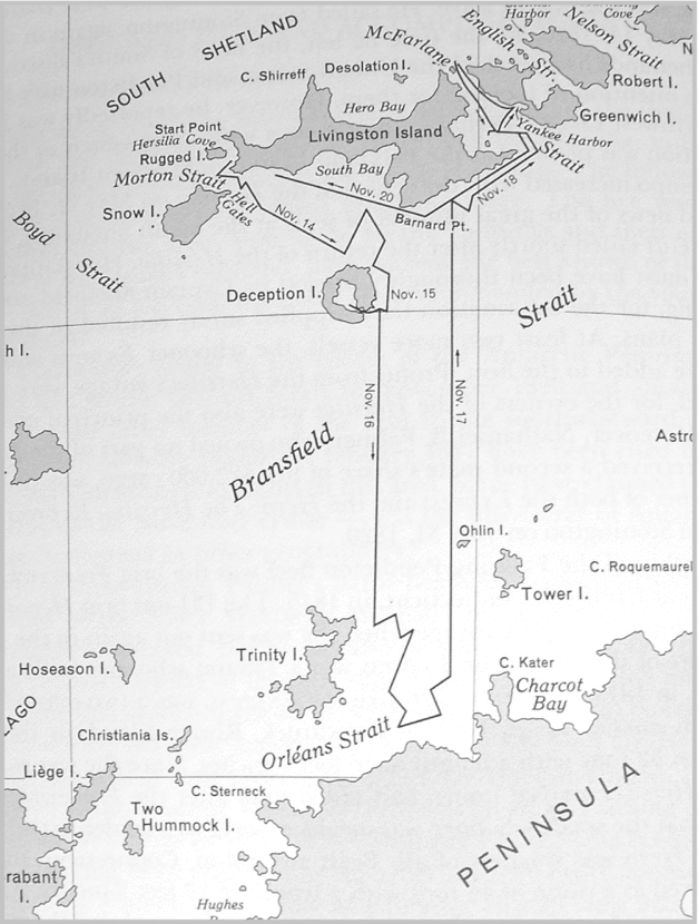
The logbook of Nathaniel Palmer's Hero, for parts of a cruise to the South Shetlands during the austral summer of 1820 and 1821, has been preserved in the Palmer-Loper family papers at the Library of Congress (Anon. 1820–1821); other relevant documents from the Stonington and other American sealers have also been examined by historians (Bertrand Reference Bertrand1971). As the smallest of the Stonington fleet, Hero was employed as a tender, ferrying skins and running various errands for the others while they concentrated on their grim harvest. By November 1820 the supply of fur seal was running low, due to intense exploitation, and Palmer was despatched by Captain Benjamin Pendleton, the leader of the Stonington group, to search for fresh rookeries. Palmer began his November cruise (Fig. 2) by exploring volcanic Deception Island, which he may have named, and where he was probably the first skipper to discover and explore the flooded caldera, which became a popular harbour for sealers. He then sailed south across the Bransfield Strait to Trinity Island and the coast of the Antarctic Peninsula, separated from Trinity Island by the ice-choked Orléans Strait. After a short inspection of the area he returned northwards to the South Shetlands and explored McFarlane Strait, between Livingston and Greenwich Islands, where he discovered Yankee Harbour on the southwest coast of Greenwich Island (Bertrand Reference Bertrand1971: 66–73). He reported to Pendleton that the land on the far side of the Bransfield Strait was even ‘more sterile and dismal’ than the South Shetlands, with no fur seal to be found (Fanning Reference Fanning1833: 434–435). In December 1820 Palmer made several circumnavigations of Livingston Island. In January 1821 he was sent on a second reconnaissance, the details of which are uncertain. Sealing documents suggest that he explored the northeastern part of the South Shetlands. Sources also refer to one or more cruises southwest along the coasts of the Antarctic Peninsula in January 1821, and Bertrand concluded that the most likely vessel to have made such a cruise was Palmer's Hero, possibly with Pendleton on board and in overall command (1971: 82–83). Martin (Reference Martin1940: 551) suggested, with some plausibility but without noticing that Bellingshausen was using a ship's date one day ahead of the Julian calendar, that Pendleton and Palmer may have sighted land south of the Antarctic Circle, in the shape of Adelaide Island, at about the same time that Bellingshausen registered the same landmark achievement with Peter I Island on 21 January 1821. With no records surviving from the January American voyage the relationship between the two events cannot be determined.
Track of Palmer's first reconnaissance of the south side of Bransfield Strait in November 1820, from Bertrand (Reference Bertrand1971: 62).

Evidently Palmer met Bellingshausen in February 1821, as recorded by the latter. But there is no entry in Hero's logbook for the day in question, nor for two weeks on either side of it, and there are no other primary American sources for the date, which has simply been misread as 6 February from Bellingshausen by historians who were unaware that his ship's date was a day ahead of the Julian calendar. Palmer's only surviving description of the meeting was written many years later, in 1876.
The American accounts will be discussed in chronological order. The first was a letter to a Washington newspaper written by the journalist and ‘projector’ Jeremiah Reynolds less than eight years after the event. Since it bears on four different early Antarctic explorations (Bellingshausen, Palmer, Reynolds and Wilkes), and does not appear to have been republished, it is given here in full:
Gentlemen: In performing some of the duties assigned me by the Secretary of the Navy, during the past Summer, I had occasion to address a circular letter to a number of masters and owners, of the whale fishery, and fur seal and other trades in the Pacific, with a view of collecting such information as they had treasured up, in the numerous voyages they had made in high Southern latitudes, that might be useful to the Navy Department, in directing the operations of the exploring expedition, now preparing for the enterprise. Answers were readily returned to my letters; log books and journals were freely offered for examination, and a disposition to communicate freely was evinced in every personal interview I had with the intelligent gentlemen engaged in the several branches of the business of the Pacific. This information has been combined in a report to the Department. In the course of these researches, many anecdotes, strongly illustrative of the enterprise, hardihood, and success, of our mariners, have been collected by me, and which were either too minute, or did not come within the objects of my report, which, however, I esteem of great value, and shall preserve for future use. One of this kind I have recently received from Captain E. Fanning, a gentleman distinguished for his adventurous and successful voyages in the Southern Hemisphere, and I cannot forbear to communicate it to the public, as it ought to be known, to show our enterprise, and Russian justice and liberality. Respectfully, yours, &c. J.N. REYNOLDS
‘While on the business of discovery, (says the Captain [Fanning – RB]) I cannot but digress, to mention a little circumstance, to the credit of American enterprise, viz: The two discovery-ships sent out by the late Emperor Alexander of Russia, on their voyage round the world, being between the South Shetland and Palmer's Land, but much the nearest to the islands, were becalmed in a thick fog; when the fog cleared away, they were surprised to find one of the Stonington South Sea Company's barques, a little vessel of about fifty tons, between the two discovery-ships, which immediately run up the United States’ flag, when the frigate and sloop of war set theirs, and the Russian Commodore dispatched a boat and officer, with an invitation to Captain Palmer, of the American vessel, to come on board, which he readily accepted.
‘When he arrived on the Commodore's deck, he was asked what islands those were in sight, and if he had any knowledge of them? “Yes, Sir,” replied Capt. Palmer, “those are the Shetland Islands, I am well acquainted with them, and a pilot here. I belong, Sir, to a fleet of five sail, out of Stonington, under the command of Captain B. Pendleton, whose ship is now at anchor in a good harbor in that island; and if you wish for water or refreshments, I will pilot you in, and my Commodore will be much pleased to render you any assistance, to obtain for you such refreshments as the country affords.” “I kindly thank you, Sir,” said the Russian Commodore,” but, previous to being enveloped in the fog, we had a sight of those islands, and concluded we had made a new discovery; and behold, when the fog lifts, to our utter surprise, a beautiful little American vessel, to all appearances in as fine order as if she had but yesterday left her port in the United States, is discovered alongside of my ships, the master of which readily offers to pilot my vessels into port, where his Commodore will tender me every aid for refreshments! We must surrender the palm of enterprise to you Americans,” said the Russian Commodore. “Sir, you flatter me,” replied the [A]merican Captain; “but there is an immense extent of land to the South, and when the fog is entirely cleared away, you will have, from your mast head, a finesight of its mountains.” “ Indeed,” observes the Commodore, “you Americans are a people that will be before us, and here is now in your information, and what is now before my eyes, an example and pattern for the oldest nation in Europe. Where I expected to make new discoveries I find the American flag, a fleet, and a pilot!”
‘After treating Captain Palmer in the most friendly manner, the Russian Commodore was so much struck by the circumstance that he named the coast Palmer's Land, and it bears his name, at this time, on the recent Russian and English charts.’ (Reynolds Reference Reynolds1828 – emphasis in the original)
Reynolds had been lobbying for an expedition since 1826, but he dated Fanning's information to 1828, ‘during the past Summer’. When Fanning first heard the story from Palmer is impossible to say, but to judge from Spears’ biography of Palmer it was perhaps around 1824 or 1825, when rumours about possible new sealing grounds stirred fresh interest in exploration in Stonington and Nantucket (Spears Reference Spears1922: 111–115).
Five years later Fanning published a more detailed version which identified the Stonington ‘commodore’ as Benjamin Pendleton. He explained that Pendleton had sighted land far to the south from a lookout high up on Deception Island, and had then sent Palmer to reconnoitre it for seals. Palmer had met Bellingshausen ‘on the Hero's return passage’ from that cruise. Fanning then described the meeting much as he had done to Reynolds in 1828 (Fanning Reference Fanning1833: 435–438).
A few years after Fanning, Reynolds published a second, condensed version of the account he received from Fanning in 1828 (Reynolds, Reference Reynolds1836: 33–34). He made one important change, stating that the ships had been ‘much nearer’ to Palmer's Land, that is the peninsula, than to the South Shetlands. But since the Russian and the other American accounts said the opposite, it is reasonable to suppose that that was a slip of the pen, confusing ‘latter’ and ‘former’. Reynolds was also the first to name (and misname) the Russian commander, in this case as ‘Stanjykowitsch’ (1836: 34).
The next American version was written by Palmer himself, at the age of 75, in a letter to F.T. Bush:
My first command was the Sloop ‘Hero’ in 1820. it was on this Voyage that Palmers Land was discovered & subsequently we fell in with the Russian Squadron under Admiral Krustenstern consisting of Frigate ‘Rostock’ and a Sloop of the name I have forgotten. it was with great difficulty that I could make the old Admiral believe I had come from U States in so small a vessel. he treated me with great kindness for the services I rendered him in extricating his Ship from a dilemma he found himself when the Fog lit [let – RB] up surrounded by Land and other obstacles. & as we were the first vessel that had circumnavigated the Shetland Group & had to make our own Charts – from which he took a Copy on Tissue paper was the means of taking his Ship from all the dangers and proceeded on his way to Rio Janeiro. among other things I informed him of our Trip to the South in Latt 68º and the discovery of a Land (now before him) and it was him that named it Palmers Land. (Palmer Reference Palmer1876)
One commentator has declared that the letter ‘was not written in Palmer's hand’ (Jones 1982: 108). There are certainly graphological differences between the letter and logbook entries written 55 years earlier, but there are also similarities.
Later American versions include a newspaper article by F.T. Bush (Reference Bush1881) based on the letter and on recollections of a verbal account given by Palmer at Hong Kong in the 1840s, and another, said to be based on a lost journal and other family papers, by Palmer's niece, Margaret Loper (Loper Reference Loper1907). Those versions, which were followed by Palmer's first biographer (Spears Reference Spears1922: 70–75), added little to the American account of the meeting apart from putting ever more florid language into Bellingshausen's mouth and adding a suitably Romantic overture, with ships’ bells sounding eerily through the Antarctic fog.
General remarks
Palmer and Bellingshausen were always likely to have different recollections of what was said. Bellingshausen was not fluent in spoken English, and may have relied on Midshipman Dmitrii Demidov of Vostok or Lieutenant Mikhail Lazarev, Mirnyi's commander, to do most of the talking. (One of the later versions mentions an interpreter (Bush Reference Bush1881).) Lazarev had served in the Royal Navy; Demidov interpreted for Bellingshausen at Sydney, but it is not known where he learned English. Given that the squadron was on an uncharted lee shore, perhaps in poor visibility, so that Lazarev probably should have stayed with his ship, and given that Bellingshausen mentions other visits to Vostok by Lazarev in his book but not on this occasion, the officer most likely to have been sent across to Hero and then acted as interpreter is Demidov. Bellingshausen may have instructed such an intermediary to flatter the American outrageously in order to gain as much information as possible, but have taken little interest in just what compliments were then paid to the visitor. Furthermore the parties came not only from different countries but also from different social backgrounds. European officers were accustomed to exchanging elaborate but largely meaningless courtesies, especially between representatives of different nations. Yankee seafarers were more given to saying only what they meant, or else holding their peace.
Next, it is evident from both accounts that the Russians dominated the conversation. They had the advantage of Palmer in numbers, rank and languages. They learned much about the Stonington sealers; Palmer learned very little about the Russians, not even the name of their commander. In particular, he appears to have learned nothing about their recent discoveries.
Thirdly, both the Russian and the American accounts of the meeting were set down within a few years and were independent of each other. Bellingshausen finished his book in October 1824, before any American description of the meeting had been published. He had little further to do with the book while it was subjected to indifferent editing and bureaucratic delays before being published in 1831. Likewise the American versions were evidently derived from Palmer and formulated without seeing Bellingshausen's account.
The only recorded instance of one eye-witness responding to another is Novosil’skii's remark of 1853, quoted above, that Palmer gave Bellingshausen information about sealing but nothing more. This was clearly intended to deny the statement, published in the United States, that Palmer had provided Bellingshausen with important geographical information. Novosil’skii and Bellingshausen became members of the Russian Geographical Society, founded in 1845, and would have had opportunities to discuss the American account, most probably in the version published by Fanning (Reference Fanning1833). Although Bellingshausen died shortly before it was published, the denial must surely derive from him since Novosil’skii, a junior officer on the squadron's support ship, is unlikely to have been present at the original conversation.
A final general point is that both the Russian and the American narrators were aiming at something more than factual accuracy. Bellingshausen would have seen it as his duty to his sovereign, his crew and himself to present his expedition in the best possible light. And from 1826 onwards Reynolds and Fanning were crying up the prowess of Yankee mariners while lobbying for a United States exploring expedition to the Antarctic and the Pacific, from which they hoped to derive commercial gains.
The circumstances
At first glance the two accounts give very different descriptions of the circumstances leading up to the meeting. According to Bellingshausen, after proceeding slowly along the coast of Smith Island and then on to Snow Island on 4 February 1821 he waited south of the latter for Mirnyi to catch up with Vostok during the brief Antarctic night. At 2 a.m. on 5 February he resumed his cautious running survey of Snow Island before crossing the mouth of Morton Strait, between Snow and Livingston Islands, and turning along the coast of Livingston. After sighting Deception Island he entered the strait between Livingston and Deception Islands, where he met Palmer in Hero.
Fanning alone mentions that Pendleton saw the Peninsula from a lookout on Deception Island before sending Palmer to reconnoitre it. He then conflates Palmer's first crossing of the Bransfield Strait, in November 1820, with the second, in January 1821, if we accept, with Bertrand, that both took place. Fanning, Reynolds and Palmer himself concur that the meeting happened soon after what must have been the second reconnaissance. The Americans then state that all three vessels were becalmed in fog, probably at the location given by Bellingshausen, to judge from Palmer's ‘surrounded by Land’ (1876), and became aware of each other as it lifted.
The two descriptions of the weather are not wholly incompatible. It should be noted that Bellingshausen's masthead was roughly twice the height of Palmer’s; that Bellingshausen and his men had as much if not more experience than Palmer of navigating Antarctic coasts and ice fields in poor visibility; and that weather conditions probably varied from place to place that morning. So Bellingshausen could have been under way for several hours with light winds and patchy fog, not hampering enough to deserve a mention, while Palmer was waiting for a wind in denser fog between Deception and Livingston Islands. As the Russians approached that point a lookout may have spotted Hero from above, and Bellingshausen may have welcomed the opportunity to gather information from Palmer while waiting for local fog to disperse. With a wind rising by about 11 a.m. the fog would have cleared and Palmer would have wanted to return to his boat; hence the brevity of the meeting. Such a scenario would also explain the use of warning bells, since both parties knew there was other shipping in the area. (The Russian ships would also have marked the time at 10 a.m. with four bells.) And in such conditions Palmer might have observed only the final stage of the Russian squadron's approach, when the ships hove to after, possibly, sounding warning bells to gain his attention.
The conversation
Two elements in the conversation between Palmer and Bellingshausen are not at issue; first, that Palmer received little if any information from the Russians, and second that Palmer gave his hosts an accurate picture of the seal hunt. The Russian and American accounts disagree, however, about whether Palmer conveyed detailed geographical information about the region. In 1853 Novosil’skii repeated what was surely Bellingshausen's denial of that assertion as made by third parties, but in 1876 Palmer confirmed those accounts. A strikingly circumstantial element in Palmer's version was his claim to have allowed Bellingshausen to copy a map that he, Palmer, had drawn. According to all the American versions land was in sight to the south, across the Bransfield Strait, at some point in the conversation. The Russian version does not mention that.
All accounts agree that the South Shetland Islands were one of the topics of conversation. If Palmer gave Bellingshausen geographical information it would probably have included his recent discoveries: the volcanic nature and hidden lagoon of Deception Island and the layout of McFarlane Strait, between Livingston and Greenwich Islands, where Palmer found two good harbours, one on Half Moon Island and the other, Yankee Harbour, on the southern side of Greenwich. Palmer was also in a position to reveal the existence and approximate whereabouts of a mountainous coastline to the south of the South Shetlands, but all sources and commentators agree that he made no detailed records of it because he found neither harbours nor seal rookeries.
For and against Palmer
Palmer's account of the conversation was collected by Reynolds from Fanning less than eight years after the event. It was confirmed by Palmer in a letter written after an interval of 55 years. Palmer had no motive for withholding his discoveries, since Bellingshausen was not a competitor and in one area, the future Palmer's Land on the other side of the Bransfield Strait, Palmer had found no rookeries anyway. Furthermore the sealers were about to disperse to the waterfront taverns of North America and Europe, taking the information with them. It also speaks for Palmer's honesty that, when writing for himself (1876), he did not claim to have discovered Palmer's Land, merely to have explored it after it was discovered.
As pointed out by several commentators (Debenham Reference Debenham and Debenham1945; Berg Reference Berg1951), some parts of the American account of the conversation are thoroughly unconvincing. The Russians cannot have been ‘surprised’ at meeting Palmer's boat, since they had already seen eight boats in Morton Strait that morning and people in a skiff at Snow Island the previous day. (Fanning attributed some of the surprise, more plausibly, to Palmer.) And next, the Russians cannot have supposed they had made a ‘new discovery’ or asked what the islands were, since they had been informed of the existence and location of ‘New Shetland’ in a letter from the Russian ambassador at Rio de Janeiro, received at New South Wales in 1820. They were probably also told that the discovery was connected with the sealing industry. Something complimentary may of course have been said about the diminutive size of Palmer's sloop.
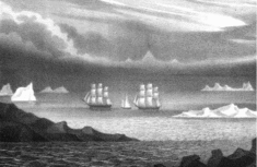
The question whether part of the Antarctic Peninsula could have been in sight from the location of the meeting is fairly straightforward. The question whether it actually was in sight is more debatable. A reasonable estimate of Vostok's position, at the eastern end of the strait between Deception and Livingston Islands, is 62.8714º S 60.3566º W. The great circle distance from that point to the 312m summit of Tower Island is 82km, and to the nearest mainland cliffs, 200m high, it is 107km. Both distances are greater than the standard sea-level horizons for such altitudes of 68km and 54km respectively. In the case of Tower Island, however, the height of a lookout at, say, the main-topgallant crosstrees could have brought the summit within sight in clear weather. The mountainous spine of the Antarctic Peninsula provides a stronger case for the American version. The highest point on a transect roughly opposite Vostok's estimated position is 1616m on the Detroit Plateau, at an approximate distance of 133km (Anon. 1996). The standard horizon for that altitude is 158km. In ideal conditions, such as a clear atmosphere and optimal illumination of the Plateau, the Peninsula may therefore have been visible from Vostok's deck even without the aid of the ‘superior mirage’ phenomenon. But such conditions are rarely present in the Bransfield Strait. One thing we do know about the usual visibility of the Antarctic Peninsula during the austral summer is that most of the early sightings, such as those by Bransfield in January 1820 and by Palmer himself in November 1820, were achieved by going closer to the coast than Vostok's position on the morning of 5 February 1821. The illustration of the scene in Fanning's Voyages (Fig. 3) should therefore be treated with caution. A striking feature in the early American versions is that they have Palmer predicting that the Peninsula would be visible when the fog cleared, which seems too bold to be convincing.
The Palmer-Bellingshausen meeting, as imagined in Fanning (Reference Fanning1833: 45). The foreground probably represents Neptune's Bellows, the channel leading into the caldera on Deception Island.

Next, the American account contains more trivial errors than the Russian. Vostok was a sloop-of-war, but the ‘frigate’ error may have arisen because her lines followed a design for a ‘cut down frigate’ (Bulkeley Reference Bulkeley2014: 26). Ships of the Imperial Navy were unlikely to be named after a Hanseatic port like Rostock, but an ornate and weather-beaten capital ‘V’ in Russian could look like an ‘R’ to a foreigner. The tendency of a good tale to grow in the telling explains why Bellingshausen grew in years and rank over time. As for his misidentification, Krusenstern and Stanyukovich had commanded expeditions to the North Pacific before and after Bellingshausen went south. But not even Krusenstern was an admiral by 1821. In the same spirit the meeting grew longer in successive versions and ‘business’, such as taking a meal or sending a boat to fetch a map from Hero, was supplied to fill the time.
Lastly under this heading, ever since the original version (Reynolds Reference Reynolds1828) the appearance of Palmer's Land ‘on the Russian . . . charts’ has been mentioned as if it confirmed the American account of the meeting. The only Russian maps cited are those in successive editions of Krusenstern's Atlas of the Pacific. The first edition showed land south of the South Shetlands without naming it (Krusenstern, 1824: sheet 1). A later edition corrected to 1835 (the bibliography is obscure), showed a ‘Terre de Palmer 1824’ in roughly the same place (Hobbs Reference Hobbs1939: plate VII). But such a feature from such a date is irrelevant to the claim that Bellingshausen invented the name. Krusenstern himself saw Palmer's Land as probably part of a continental mainland, but also described it, confusingly, as ‘part of the South Shetland Islands’ (Krusenstern 1836: 30).
For and against Bellingshausen
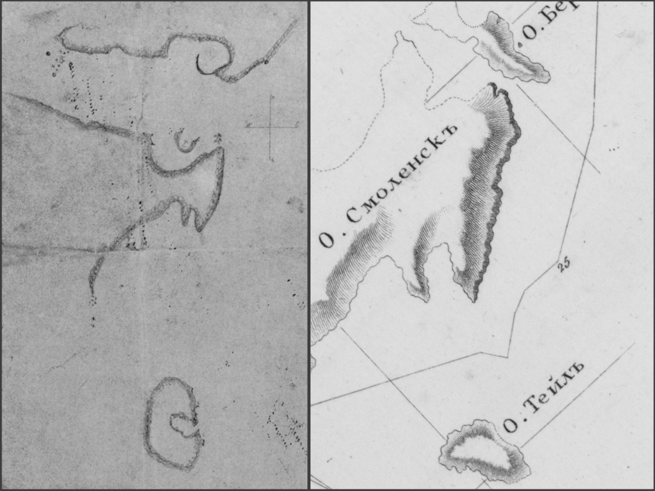
Bellingshausen noted his meeting with Palmer within months of its occurrence, on the track chart, and then included it as a minor event in the narrative of his voyage. When he learned of the claim that Palmer had given him important geographical information, he appears to have rebutted it (Novosil’skii Reference Novosil'skii1853). Bellingshausen's maps of the South Shetlands, on the track chart and in his later Atlas volume, do not show the crater lagoon of Deception Island. A sketch map of the area attributed to Nathaniel Palmer, and here oriented with magnetic north at the top, shows Deception Island with its lagoon below parts of Livingston and Greenwich Islands separated by McFarlane Strait (Fig. 4a). The southeastern part of McFarlane Strait shows Half Moon Island opposite and below Yankee Harbour. Bellingshausen's track chart (Fig. 1) merely shows the southeastern entrance to the strait with no further details. After orienting a detail from his subsequent Atlas sheet on a similar alignment to Palmer's sketch (Fig. 4b), and allowing for the latter's poor rendering of scale, it can be seen that Bellingshausen probably shows the harbour on Half Moon Island, but not the island itself, and that none of his coves on the Greenwich Island (upper) side of the strait bears much resemblance to Palmer's rendering of Yankee Harbour. On the northwest side of the South Shetlands Bellingshausen surveyed only the northern part of King George Island. However northwestern shorelines were outlined for all the islands in the Atlas sheet, going beyond what Bellingshausen had seen for himself in 1821. Purdy (Reference Purdy1822) is one of the few sources from which he could have borrowed before finishing the book in October 1824. The Atlas sheet may not have been engraved until several years later, after detailed maps of the South Shetlands began to appear either separately or in atlases, as for example Brue (Reference Brue1826), Vandermaelen (Reference Vandermaelen1827) and Lapie (Reference Lapie1828). But unfortunately none of those mentioned, nor any of those collected by Hobbs (Reference Hobbs1939), bears much resemblance to the Atlas sheet. And the Atlas departs from most contemporary maps of the South Shetlands in not showing a coastline to the south, on the other side of the ‘Détroit Branfiel’ (Brue Reference Brue1826).
A sketch map attributed to Nathaniel Palmer (left) shows Deception Island at the bottom, followed by parts of Livingston Island, McFarlane Strait and Greenwich Island in ascending order with magnetic north at the top (Martin Reference Martin1940: 533). The corresponding part of a map published by Bellingshausen (right) has been oriented to a similar alignment (Bellingshausen Reference Bellingshausen1831, Atlas, Sheet 62, detail).

If the cartographic evidence tends to support Bellingshausen's apparent rebuttal of Palmer, other considerations have the opposite effect. By January 1821 the men of the Russian squadron were still in fairly good shape but the ships were anything but. Vostok, in particular, had to be nursed back to Rio with several knees broken and her pumps working night and day. At Rio, Bellingshausen managed to acquire 18 new knees (Bulkeley Reference Bulkeley2014: 116). There would have been at least 200 of those key components in Vostok's frame, of several types, but there is no way of knowing how many more were also in need of replacement. With his ship losing her seaworthiness the prospect of turning south yet again, towards an ice-bound coast that had already been discovered and explored by others, would have been a daunting one. So Bellingshausen might have been faced with that option, after listening to Palmer, and might have rejected it as an unwarranted risk on the eve of completing his successful circumnavigation of the Southern Ice Ocean. It may be significant that he offered an explanation for what he did next:
I proposed to proceed from the position at which we lay along a bearing of NEbE, with a view to learning whether the mountain chain [of islands – RB] continued. (Bellingshausen Reference Bellingshausen1831, II: 268).
The decision amounted to following the route he would have taken anyway, towards South Georgia and Rio de Janeiro, and resulted in two days of exploration at the Elephant and Clarence group.
Another reason to suppose that Bellingshausen may conceivably have suppressed information received from Palmer is that he had already done something similar, though less significant, elsewhere. While the expedition was surveying South Georgia in December 1819 they were visited by three men from an English sealer, one of whom, nicknamed Prusak (Cockroach), spoke such good Russian that Bellingshausen took him for a naval deserter (although he did not treat him like one). Bellingshausen was en route for one of Cook's discoveries, Sandwich Land, with a view to determining, as Cook had not been able to do, whether it was a group of islands or part of a more substantial mainland. According to the expedition's astronomer, Ivan Simonov, Prusak stated that the sealers had visited Sandwich Land more than once and found two volcanoes there (Bulkeley Reference Bulkeley2014: 146). They would certainly have combed the area for beaches and seal rookeries, and in that process they were bound to have ascertained that it consisted of islands rather than a single land mass. It is therefore highly probable that they told Bellingshausen as much, although Simonov does not say so in his brief journal entry. On the track chart, Bellingshausen notes the visit but none of the conversation. In his book he relates what the sealers told him about their fishery, but not what they told him about Sandwich Land, such as the volcanoes, a very useful seamark for explorers and one which had not been observed by Cook (Bellingshausen Reference Bellingshausen1831, I: 127–128).
Literature and conclusions
In 1937 a Soviet textbook on the history of Antarctic exploration, with inputs from leading geographers, accepted the later, embellished American version of the meeting without demur (Grigor’ev Reference Grigor’ev1937: 27–28). Once the dispute over priority of continental discovery had set in, and had then been exacerbated by the Cold War, the gesture could not be repeated. A definitive analysis of the meeting by Lev Semyonovich Berg, president of the Soviet Geographical Society, was published posthumously in 1951. Berg relied heavily on his estimate of Bellingshausen's character. Palmer could not be right because Bellingshausen, who was ‘generally known to be punctilious’ (1951: 29), never reported receiving any such geographical information. As for the speeches put into his mouth in later American versions, they were quite out of keeping with his reserved and guarded personality. Furthermore, if Palmer had mentioned his discovery of land to the south, Bellingshausen would surely have reciprocated with his own recent discoveries; but he did not, therefore Palmer did not (Berg Reference Berg1951: 30). The article alternated between begging the question of Bellingshausen's character and harping on some of the later, implausible elaborations of the American story. The issue of whether the Peninsula was in sight was mentioned, but not discussed. But Berg was writing without all the evidence. Perhaps he had not seen Bellingshausen's reports, most of which were first published in 1952. In them Bellingshausen withheld the details of his Antarctic (but not his Pacific) discoveries because the mails to Europe were not secure, a precaution which suggests that he may well have restrained himself from passing to an American stranger information of national importance which had not yet reached the Emperor. Nor could Berg have known that Bellingshausen had had a conversation with sealers at South Georgia which he did not report in full, since no one had mentioned that episode since 1822 (Bulkeley Reference Bulkeley2014: 146, 199).
This author could find no subsequent scholarly analyses of the meeting in Russian factual literature, although it has often been mentioned. The usual practice was either to give no details (Magidovich Reference Magidovich1957: 624), or else to quote or summarise Bellingshausen's ‘sealing only’ description of the meeting without mentioning the American narratives (Berg Reference Berg1949: 184; Burkhanov Reference Burkhanov1956: 34; Treshnikov Reference Treshnikov1963: 29, 34). More recently, the Russian oceanographer Lukin (Reference Lukin2005) has displaced the meeting by several days and islands to 30 January 1821 off King George Island, a position which Bellingshausen would have to have reached in two days from Alexander I Island, but which actually took him nine. (The great circle distance is about 1000km; the actual route may have been half as much again.) In Lukin's reconstruction Palmer tells Bellingshausen that even if he has found land to the south it means nothing to him because there is nothing there to hunt. Then Palmer adds, in direct speech: ‘There is nothing interesting in that God-cursed country of rock and ice’. Lukin thus became the first Russian commentator since 1937 to accept that Palmer did tell Bellingshausen about the existence of a body of land south of the South Shetlands (Lukin Reference Lukin2005: 77).
The meeting has also featured in Russian historical fiction per se, to which it is well suited. There has been no unanimity of treatment. In one novel Palmer points fearfully southwards towards, not land, but a mysterious and deadly ice barrier (Vadetskii Reference Vadetskii1957: 174). In another, overseen by no less an authority than Bellingshausen's Soviet editor, Palmer tells Bellingshausen about ‘land to the South’ but can provide no details because he is concerned with nothing but the seal hunt (Ostrovskii Reference Ostrovskii and Shvede1966: 77). (This may have been, in part, the fictional ‘source’ for what Lukin presented as fact (2005), though neither for his erroneous venue nor for the words he placed in Palmer's mouth.) More recently Russian novelists have turned the tables by imagining that Bellingshausen shows Palmer a map of Peter I Island and Alexander I Coast (apparently dashed off in the intervening week of hazardous ice navigation), only for the American to express his total lack of interest in such matters (Firsov Reference Firsov1998: 224–225; Fyodorovskii Reference Fyodorovskii2001: 410–411).
Turning to the English-speaking world, in the first part of the twentieth century partisan advocates of American priority in Antarctica accepted the later, elaborate versions of Palmer's story without question (Hobbs Reference Hobbs1939; Martin Reference Martin1940). A process of reassessment was initiated by Frank Debenham, who discussed the meeting in the introduction to his translation of Bellingshausen's book. Debenham gave short shrift to the later, ‘ornamental’ American versions, but was reluctant to accept either that Palmer's claim to have mentioned land to the south was a complete fabrication, or that Bellingshausen had suppressed the truth. He suggested instead that the two men had been unable to understand one another (Debenham Reference Debenham and Debenham1945: xxv). That was unconvincing, because the expedition had been provided with English-speaking officers, for obvious reasons, and had managed perfectly well in Britain and New South Wales.
After Debenham's intervention American historians began to credit the Russian account of the meeting at Palmer's expense. Stackpole solved the problem by dismissing Palmer out of hand:
Had Captain Palmer told Admiral Bellingshausen that he had discovered land to the south, as has been claimed, it is fair to expect Bellingshausen to not only record such an important fact but to have turned south himself to seek it. The Russian had already penetrated the Antarctic circle several times searching for land and had purposely come to the South Shetlands to ascertain whether or not these islands had any connection with a southern continent. He would never have departed without investigating any information such as historians claim Captain Palmer gave him. (Stackpole Reference Stackpole1955: 61–62; see also Jones 1982: 107–109)
The trouble with that solution is that the claim that Palmer provided geographical information comes, not merely from ‘historians’, but from Palmer's own hand in 1876. It is also plausible, because Palmer had no reason to withhold the information and would doubtless have enjoyed showing off to his audience. Bertrand surmised, instead, that Palmer had informed Bellingshausen but the latter ‘thought Palmer's story not entirely credible and therefore discounted part of it’ (1971: 79). But that hypothesis mistakes the nature of maritime exploration at the time. Just like Cook and other expedition commanders before him, Bellingshausen put considerable effort into checking putative discoveries based on slender evidence, such as Company Island south of Australia. Far from giving up on the practice he was about to make a second attempt at one of them, Isla Grande, after leaving the South Shetlands.
None of the western commentators had seen all the Russian sources, and they appear not to have appreciated that, in essentials, Palmer's account of the meeting dates from the 1820s rather than the 1830s.
The present author does not believe that Palmer can be dismissed so readily. Let us consider the possible transfer of geographical information in its component parts, starting with the claim about copying a map. That is a late element, but it has Palmer's own testimony to support it (1876). To judge from the sketch maps attributed to him (Fig. 4a), Palmer was no great surveyor. But the real problem for this part of his story is that Bellingshausen's maps show no sign of the most likely input from Palmer, the caldera lagoon on Deception Island. On that basis, we can venture to suppose that Palmer's memory was unreliable in later life, or that he had been persuaded by his audience to enhance the tale, and then told it so often that he came to believe it.
Take, next, the statement that the Antarctic Peninsula was in sight at Vostok's position. That was a physical possibility, and it forms part of Palmer's story from its first version onwards. Against it is the unlikely claim that Palmer felt able to predict that the Peninsula would appear before it actually did so. A more telling consideration is that if the mountains of the Peninsula were in sight they would have been revealed not only to Bellingshausen but also to 186 other members of his expedition, who would shortly have returned to Russia with the sensational news that their commander had chosen to ignore the very thing he was ordered to look for. It is pertinent to note that in 1819 Bellingshausen stayed in London for almost three weeks, at a coffee-house much frequented by naval officers, just when a scandal erupted over allegations that Captain John Ross, RN, had done something similar in the Arctic (Sabine Reference Sabine1819).
But even if we set aside the talk about a map, and the claim that the Peninsula was actually in sight during the meeting, there remains the thorny question whether Palmer told Bellingshausen anything substantial, either about the South Shetlands or about the discovery of further land to the south. It is very hard to believe that Bellingshausen neither requested nor received information about the islands from a fellow mariner who was so well placed to provide it. Indeed Palmer's description of the anchorage in Morton Strait was itself hydrographic information. And it does not help Bellingshausen's case that he never acknowledged that sealers had alerted him, in 1819, to the volcanoes in Sandwich Land.
The main issue, of course, is whether Palmer told Bellingshausen about ‘an immense extent of land to the South’ (Reynolds, Reference Reynolds1828), and if so, how Bellingshausen could have ignored him. Let us suppose that Palmer did give that information to Bellingshausen, his loyal aide Ivan Zavodovskii, and a few other officers. Perhaps Bellingshausen could justify to himself a decision not to head back into heavy ice with his ship already badly damaged. And perhaps it followed that he would keep silent about Palmer's revelation and even instruct his officers to do likewise. He may also have felt, or persuaded himself to feel, that it was not for him to publish other men's discoveries before they did so themselves. But how could he hope to keep the matter secret, and in fact succeed in doing so? The expedition's astronomer, Simonov, was both friendly with Demidov, who probably acted as interpreter for the meeting, and a notorious gossip. Could he have kept Bellingshausen's secret while describing the expedition repeatedly to everyone he met during a scientific trip around western Europe which lasted for almost two years, between 1823 and 1825? And was Lazarev so conscientiously discreet that he withheld Palmer's information from a long private letter to his old friend Shestakov, with whom he shared most of his experiences over many years, written soon after the expedition returned to Russia (Bulkeley Reference Bulkeley2014: 166–171)? But if Palmer did tell Bellingshausen about ‘land to the South’, then either Bellingshausen kept the information from most of his officers, or there must have been a remarkably effective conspiracy of silence.
Faced with such an even balance of evidence and probability on both sides of the argument, the present author can find no way to settle the issue except from considerations of motive. If we credit Bellingshausen's denial, we must conclude with Stackpole that Palmer's claim to have told the Russian commander about the existence of further land to the south was wholly false. But neither Palmer nor his sponsors Reynolds and Fanning had any conceivable motive, in the 1820s, for making up such a tale. If on the other hand we accept the core of Palmer's story, without its later embellishments, there is an outside chance that, after deciding that his ship was in no condition to investigate the matter, Bellingshausen chose to say nothing about the report of a mere sealer, much as he did with others at South Georgia. When he wrote his book in the early 1820s he was not to know that Palmer's account of the meeting would be published a few years later, and in any case he saw himself as a risk-taker (Bulkeley Reference Bulkeley2014: 24). Once Palmer's story had been published by Reynolds and Fanning, he would have had no choice but to rebut it.
Bellingshausen was undoubtedly a decent man, an excellent navigator and a first-class hydrographer, but he could still make an error of judgement under pressure and that is, marginally, the least unconvincing interpretation of evidence which remains intractably incomplete and contradictory. It is not a satisfactory conclusion, and if further research into, say, Reynolds’ papers were to uncover convincing evidence that Palmer's story was concocted for some now unguessable reason, it would be only too welcome to the present author. In the end, to borrow a thought from Lewis Carroll, the Bellingshausen–Palmer meeting is perhaps the event in Antarctic history that, more than any other, requires us to believe ‘as many as six impossible things before breakfast’ (Carroll Reference Carroll1872).
Acknowledgements
The author would like to thank Helen Sullivan and Geoffrey Thomas Ross, librarians at the University of Illinois Urbana-Champaign, for a copy of the pages in Hero's logbook which are nearest the date of the meeting. He is also grateful to Christopher Kirwan for suggesting improvements to both text and argument.