INTRODUCTION
Until the late 1980s, the Northern Altai was considered to have been uninhabited during the Early Iron Age, a buffer zone between the communities of the mountains (Pazyryk culture) and steppes (Bolshaia Rechka culture) (Mogilnikov Reference Mogilnikov1986). This only changed in the 1990s and the early 21st century, when research carried out by M T Abdulganeev (Reference Abdulganeev1992, Reference Abdulganeev1993), A P Borodovskiy and E L Borodovskaya (Reference Borodovskiy and Borodovskaya2013), and S M Kireev (Reference Kireev1991) resulted in the discovery of a large number of Scythian period sites in the region, including large, unlooted barrow cemeteries. Until recently, there have been very few attempts to refine their chronology by means of radiocarbon (14C) analysis. Although studies oriented toward narrowing the chronology of the Pazyryk culture using natural science methods are relatively advanced (with regard to both dendrochronology and 14C methods; see Zaitseva et al. Reference Zaitseva, Vasiliev, Marsadolov, van der Plicht, Sementsov, Dergachev and Lebedeva1998; Alekseev et al. Reference Alekseev, Bokovenko, Boltrik, Chugunov, Cook, Dergachev, Kovalyukh, Possnert, van der Plicht, Scott, Sementsov, Skripkin, Vasiliev and Zaitseva2001; Slusarenko et al. Reference Slusarenko, Christen, Orlova, Kuzmin and Burr2001; Zaitseva et al. Reference Zaitseva, Bokovenko, Alexeev, Chugunov and Scott2005; Tishkin Reference Tishkin2007:249–62), the sites linked with what is known as the North Pazyryk variant have been only marginally included. As for the Northern Altai and its immediate vicinity, this research was limited to the analysis of samples from the Chankarinskyi Dol cemetery in the valley of the Inia River, a right bank tributary of the Czarysh in the northwestern Altai (Тishkin and Dashkovskiy Reference Tishkin and Dashkovskyi2007) and from the site of Bystrovka, in the forest-steppe zone adjoining the Altai from the north (Borodovskiy et al. Reference Borodovskiy, Slusarenko, Kuzmin, Orlova, Kristen, Burr and Dzhall2002). Currently, thanks to cooperation between the Institute of Archaeology and Ethnography Siberian Branch of the Russian Academy of Sciences, Novosibirsk, the Institute of Archaeology of the Jagiellonian University, Kraków, and the Laboratory of Absolute Dating in Skała, a project is being realized, oriented toward establishing an absolute chronology of archaeological sites from the Manzherok region in the mountain valley of the Lower Katun River (Northern Altai) by means of 14C dating of samples collected from excavated barrows. The preliminary results of the project are presented in here.
Archaeological Investigation
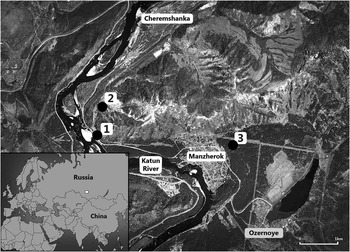
Three archaeological sites in the Manzherok region have been investigated: Chultukov Log 1 (barrow cemetery), Chultukov Log 9 (settlement), and Manzherok 3 (stronghold). The barrow cemetery of Chultukov Log 1 is one of the most important sites in the mountainous valley of the lower Katun, and the precise determination of its chronology is of exceptional significance for the investigation of the cultural processes that took place in Northern Altai during the Scythian period. This is so because Chultukov Log 1 is a large cemetery, in which various cultural traditions of the Scythian era are represented, and of particular importance (and unique in the Altai), the barrows have survived unlooted. The necropolis, investigated by one of the authors (A P Borodovskiy) since 2000, is situated on the Katun floodplain, on the right bank of the river (Figure 1). A Polish expedition from the Institute of Archaeology of the Jagiellonian University in Kraków, led by Ł Oleszczak, has also been participating in the excavations since 2012. More than 120 sepulchral features have been explored thus far, in the form of barrows with stone mounds, most often situated in rows (known as chains). The features explored represent several different cultural traditions referring to steppe cultures of the Scythian type, which can archaeologically be dated approximately from the 5th to 3rd centuries BC. Features attributed to the Pazyryk, Bystrianka (the southernmost features of that culture) and Karakoba (distinguished by burials in stone boxes) cultures were identified on the site. In addition, 10 burials of the Maima culture were identified, representing a slightly later (from the 2nd century BC until the turn of the era) tradition of the Hunnic period (II; Borodovskiy and Borodovskaya Reference Borodovskiy and Borodovskaya2013).
Locations of Chultukov Log 1 (1), Chultukov Log 9 (2), and Manzherok 3 (3) sites (after Google Earth)

The excavations also encompassed nearby settlement sites. The settlement at site Chultukov Log 9, situated only several dozen meters from the cemetery but much higher over the river, is slightly later than most of the cemetery barrows. It is presumably synchronous with the youngest objects of the investigated site, which means that it represents the traditions of the Hunnic period (Borodovskiy and Oleszczak Reference Oleszczak2012).
The third site in the Manzherok region investigated within the framework of the presented project is a stronghold at Manzherok 3 (Figure 1), which has yielded artifacts of very diversified chronology, from the Afanasievo culture of the Early Bronze Age to the Maima culture of the Hunnic period. The stronghold is situated about 100 m southeast of the village of Manzherok. In plan, it resembles an irregular oval roughly 500×100–120 m in size, with its length stretching down the slope of a hill, along the southwest–northeast axis. The earthworks are most robust in the northeastern, southern, and southwestern parts. In the southeast, there are 4–5 parallel lines of fortifications, while from the east and northeast the ramparts either could not be identified at all or a single, poorly preserved earthen embankment was recorded. The ramparts were accompanied by moats, which were the deepest (up to 2 m) in the north, east, and south, and 4–5 m wide. In the western sector the moats are merely 0.5–0.3 m deep. In three places, from the southern and eastern sides, gaps in the line of fortifications were identified, which may be interpreted as entrances (Borodovskiy and Borodvskaia Reference Borodovskiy and Borodovskaya2013).
Radiocarbon dating may help solve controversies concerning the time when the fortifications were erected, which some researchers believe took place as late as in the Hunnic period, i.e. between the 1st century BC and 5th century AD (Soionov et al. Reference Soionov, Konstantinov and Soionov2011). Although deposits linked with the Maima culture of the Hunno-Sarmatian period were discovered in the southwestern part of the site, analysis of ceramic materials from the moats, and certain features of the planigraphy and location of the stronghold, suggest it was fortified earlier, in the Scythian period (Borodovskiy and Borodovskaia Reference Borodovskiy and Borodovskaya2009, Reference Borodovskiy and Borodovskaya2013). The pattern of locating settlements on the terraces of the Katun River was different in the Hunnic period. The settlements were typically established in naturally defensive positions, most often on promontories raised over the river valley, and sometimes protected by a single ditch from the most easily accessible side. The occupation was concentrated within small areas (of approximately 0.5 ha), which resulted in the formation of a thick cultural layer. A model example of such a settlement is already mentioned site of Chultukov Log 9. To the contrary, the stronghold at Manzherok 3 and a similar site at Barangol 5 (this stronghold is located upstream of the Katun river, around 25 km from the Manzherok region) are situated on extensive hills protected by several lines of fortifications, cover an area of several hectares, and the cultural layers are very thin there.
MATERIALS AND METHODS
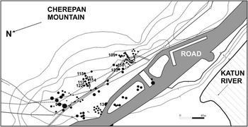
In the preliminary stage of research in Chultukov Log 1 (Figure 2), similar to the research carried out in the Bystrovka cemetery on the Upper Ob River in southern Siberia (also of the Scythian period; Borodovskiy et al. Reference Borodovskiy, Slusarenko, Kuzmin, Orlova, Kristen, Burr and Dzhall2002), 11 samples of human bones for 14C dating were collected from features representing various cultural traditions. Apart from the Pazyryk barrows (samples from features 9, 109, 122, 123), which were the most numerous group in the cemetery, samples were also taken from barrows attributed to the Karakoba (features 8, 111, 112, 114, 115) and Bystrianka cultures (feature 13). Barrows distinguished by interesting architecture (e.g. the only barrow with a niche burial—feature 109) or inventory (e.g. the remains of a wig in feature 9) were selected for sampling.
Chultukov Log 1 site plan

Another factor taken into account when selecting barrows for 14C dating was their position within a given group of barrows—samples were taken from features situated both in the center (features 8, 111, 112, 114, 115) and in peripheries of particular “chains” (features 109, 122).
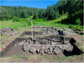
What also influenced the choice of barrows to be dated was an attempt to determine the chronology of seismic activity. In the site Chultukov Log 1, one can observe large boulders which fell from the slopes of the nearby Cherepan Mountain as a result of at least two earthquake episodes. Some of the barrows (feature 114) were erected over such boulders, while others were covered by them (feature 118, 123).
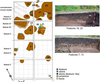
Samples for 14C analysis were also collected from the settlements Chultukov Log 9 and Manzherok 3. In the course of excavations carried out in the Chultukov Log 9 settlement (Figure 3) of the Hunnic period, 6 samples of animal bones were collected from features of various types, which means from a pit-house (feature 7) and from pits of various shapes (features 8, 9, 19, 22). The third site from the Manzherok region included in the project was the stronghold at Manzherok 3, from which 2 samples of animal bones were collected (from the moat). 14C analysis was meant to dispel the controversy surrounding the time when the fortifications had been erected.
Chultukov Log 9 site plan

In total, 19 samples were dated using the conventional liquid scintillation spectrometry (LSC) 14C dating technique in the Laboratory of Absolute Dating in Skała and Cracow, Poland (MKL signature). Organic samples were chemically pretreated with the acid-alkali-acid (AAA) method. Bone samples were disintegrated to small pieces and processed by 2% solution of hydrochloric acid at room temperature during 8–12 hr; the whole pretreatment procedure was presented by Skripkin and Kovalyukh (Reference Skripkin and Kovalyukh1999). After drying the sample, further procedures included a standard synthesis of benzene from carbonized samples (Skripkin and Kovalyukh Reference Skripkin and Kovalyukh1994, Reference Skripkin and Kovalyukh1998). Measurements were carried out with a Hidex 300 SL spectrometer (Krąpiec and Walanus Reference Krąpiec and Walanus2011).
All dates were calibrated using the OxCal 4.2 calibration program (Bronk Ramsey Reference Bronk Ramsey2009) on the basis of the IntCal13 calibration curve (Reimer et al. Reference Reimer, Bard, Bayliss, Beck, Blackwell, Bronk Ramsey, Buck, Cheng, Edwards, Friedrich, Grootes, Guilderson, Haflidason, Hajdas, Hatté, Heaton, Hoffmann, Hogg, Hughen, Kaiser, Kromer, Manning, Niu, Reimer, Richards, Scott, Southon, Staff, Turney and van der Plicht2013).
RESULTS AND INTERPRETATION
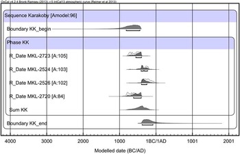
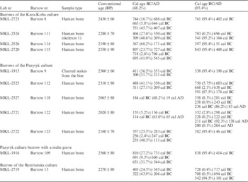
The 14C results are presented in Tables 1–3. The time span covered by the Karakoba culture barrows from site Chultukov Log 1 (features 8, 111, 114, 115; Table 1; Figures 4–5) was determined using a Bayesian model allowing for the calculation of probability distribution for the beginning, the end and the possible time span of the phase in calendar age (Figure 6). Our model indicates that the analysed Karakoba barrows represent a broad chronological range, spanning from the early 9th century BC until the beginning of 1st century BC. In this context, it is worth emphasizing that such a broad range, especially in its older section, stems from the shape of the calibration curve in this age range (Reimer et al. Reference Reimer, Bard, Bayliss, Beck, Blackwell, Bronk Ramsey, Buck, Cheng, Edwards, Friedrich, Grootes, Guilderson, Haflidason, Hajdas, Hatté, Heaton, Hoffmann, Hogg, Hughen, Kaiser, Kromer, Manning, Niu, Reimer, Richards, Scott, Southon, Staff, Turney and van der Plicht2013) and may in fact be narrower.
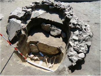
Chultukov Log 1: barrow 109

Chultukov Log 1: group of barrow nrs 8, 111, 114, and 115

Sum of probabilities for the 14C dates of samples from the Karakoba culture barrows at Chultukov Log 1.

14C dates for samples from site of Chultukov Log 1.

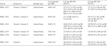
14C dates for samples from site of Chultukov Log 9.

14C dates for samples from site of Manzherok 3.

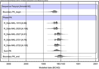
The time span covered by the barrows attributed to the North Pazyryk culture, calculated from the analogical model (Table 1; Figure 7), overlaps with that of the Karakoba barrows in the younger part but is much narrower, and generally does not exceed beyond the Scythian period: from the first half of 5th century BC until the end of the 1st century BC. The data presented above make it possible to confirm the still-debated hypothesis that the beginning of the Karakoba culture should be synchronised with the beginning of the Pazyryk culture. Such a possibility has already been proposed based on archaeological data and it may be indicative of the participation of indigenous elements in the formation of the Karakoba culture (Kubariev and Shulga Reference Kubarev and Shulga2007:13–16; Borodovskiy and Borodovskaya Reference Borodovskiy and Borodovskaya2013; Оleszczak 2012).
Sum of probabilities for the 14C dates of samples from the Pazyryk culture barrows at Chultukov Log 1.

The overall chronology of the Pazyryk culture barrows from the Chultukov Log 1 cemetery (nrs 9, 112, 118, 122, 123; Table 1) corresponds with the period when this culture was developing in the Upper Altai. This is further evidence of the early spread of this culture throughout the entire Upper Altai in the beginning of the Scythian period, which in the longer run resulted in the development of local variants, such as the North Pazyryk variant (Borodovskiy and Borodovskaya Reference Borodovskiy and Borodovskaya2013).
14C analysis of barrows from site Chultukov Log 1 is extremely important for studies into particular aspects of the contact between the Pazyryk and Karakoba populations. What makes these data even more significant is the fact that burials representing both traditions occur in the same groups (chains) of barrows, a pattern recorded not only in the necropolis discussed, but also on other the Upper Altai cemeteries (Kubariev and Shulga Reference Kubarev and Shulga2007). The most characteristic in this respect is the group consisting of barrows 8, 111, 112, 114, 115, and 122, forming a chain in the central part of the necropolis. The Pazyryk barrows from this group (nrs 112, 122) could be dated to the period from the 5th century BC (or even earlier) to the 2nd century BC–1st century AD. The Pazyryk (nr 112) and Karakoba (nr 111) barrows situated in the immediate vicinity were erected at roughly the same time (Table 1). The results of 14C dating confirm a hypothesis put forward based on archaeological data (analysis of artifacts) about the contemporaneity of Karakoba and Pazyryk barrows belonging to the same chains, with the latter sometimes regarded as groups of burials of related persons.
The 14C dates from the nearby settlement at site Chultukov Log 9 (features 7, 8, 9, 19, 22, test trench 1; Table 2) fully confirm the chronology of the site, which was determined with archaeological methods (inventory, planigraphy of the site), as belonging to the Hunno-Sarmatian period. These dates are particularly significant because we were otherwise able to correlate the settlement features with the Maima culture burials from Chultukov Log 1 (barrows 61, 70). This was possible thanks to the discovery of identical hemispherical plates with apertures for attachment in one of the settlement pits (feature 22; Table 1) and in the barrows, where they were clearly used as a headdress decoration (of a cap, or headband). The Maima culture was previously known primarily from its settlements and its burial rite has been poorly investigated, before the discovery of sepulchral features linked with this culture in Chultukov Log 1, it was known only from a single grave at the Maima VII site.
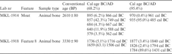
The 14C analysis also encompassed bone samples collected from a moat and from one of the pits (nr 8; Table 3) on the stronghold at the Manzherok 3 site. The establishment of chronological position is particularly important here, as scholars disagree as to the dating of the fortifications (Soionov et al. Reference Soionov, Konstantinov and Soionov2011; Borodovskiy and Borodovskaya Reference Borodovskiy and Borodovskaya2013). 14C analysis has confirmed the assumptions previously raised by Borodovskiy and Borodovskaya (Reference Borodovskiy and Borodovskaya2013) based on analysis of the artifacts recovered from the moats, and on the site planigraphy. The date of 2610±80 (MKL-1914, Table 3) obtained from one of the moats is consistent with the period 935–485 cal BC, which allows the view about the Hunno-Sarmatian chronology of the stronghold’s defences to be challenged. Also, the date of 3330±90 (MKL-1918, Table 3), which translates into 1877–1431 cal BC, obtained from the inside of the stronghold, confirms the occupation of that place (but not the construction of the fortifications) already in the Bronze Age by the population of the Afanasievo culture.
The results of 14C dating of samples from the Manzherok region from 3 sites provide important arguments supporting the chronology established based on archaeological methods (Borodovskiy and Borodovskaya Reference Borodovskiy and Borodovskaya2013). On one hand, they testify to the early settling of the microregion by Pazyryk communities (already in the Early Pazyryk period, in the 6th–5th centuries BC), while on the other they confirm the contemporaneity of barrows representing different cultural traditions of the Scythian period (North Pazyryk, Bystrianka, Karakoba). We envisage the analysis of further samples from the microregion, at least part of them from the cemetery. This will allow us to distinguish the horizons of burials and refer them to the seismic phenomena observed in the site. Earthquakes that took place in the mountain valley of the Lower Katun River in the Pazyryk period (Borodovskiy Reference Borodovskiy2011) manifest themselves in the form of landslides from the slopes of the nearby Cherepan Mountain to the cemetery. This is best illustrated by barrow 109 [niche burial dated to the Early Pazyryk period, MKL-1916: 838–414 (95.4%) cal BC; Table 1], in which the barrow’s stone mound covers boulders that had fallen from the slope, but is also covered by another landslide, as a result of a later seismic episode. Barrow 115 [attributed to the Karakoba culture and also 14C dated to the Early Pazyryk period—MKL-2720: 843–408 cal BC (95.4%); Table 1] also had a mound partly damaged by a boulder, which most likely fell there due to an earthquake. Slightly later than barrows 109 and 115, features 111 [MKL-2524: 703–696 (0.2%) cal BC, 541–164 (95.2%) cal BC], 112 [MKL-2525: 750–683 (5.75%) cal BC, 668–638 (2.1%) cal BC, 591–174 (87.5%) cal BC], 114 [MKL-2526: 397–51 (95.4%) cal BC], 118 [MKL-2527: 358–281 (8.3%) cal BC, 258–243 (0.9%) cal BC, 236 cal BC–83 cal AD (86.2%)], and 123 [MKL-2722: 382–46 cal BC (95.4%)] (Table 1) are also covered with big boulders, up to 1–2 m in size, and in some of them burial chambers bear traces of damage due to seismic processes, as well. These events were recorded in barrows 111, 115, and 123 linked to the Karakoba culture (i.e. with burial chambers in the form of stone boxes). Thus, it seems obvious that another earthquake must have occurred after their construction. All this allows for the conclusion that in the mountain valley of the Lower Katun River there must have been at least two, and perhaps three, earthquakes in the Early Iron Age. Combining these observations with archaeological evidence, one can arrive at the following conclusions:
-
1. the first earthquake predates the construction of barrow 109 [dated to 838–414 (95.4%) cal BC], since this mound covers the landslide boulders;
-
2. the second earthquake must have taken place after the erection of Early Pazyryk barrows 109 and 115 (dated to approximately 840–410 cal BC); and
-
3. the third seismic episode in this region can be linked to the Late Pazyryk period (approximately 4th–3rd centuries BC), as it resulted in the covering of barrows from the later phase by rocks that slid down the slope.
In light of the current knowledge, the first seismic episode must have taken place before the Scythian period, and the destruction of the Pazyryk barrows by the second and third earthquakes marks only the terminus post quem for these episodes. We still cannot completely rule out that the damage described in points 2 and 3 above could have been caused by one earthquake. Thus, given the promising results of the research so far, further dating should cast more light on the chronology of the seismic episodes and on the chronological relations between particular features from the Pazyryk period.
ACKNOWLEDGMENTS
Laboratory analyses and field work were financed by a grant from the Russian Scientific Fund (grant 14-50-00036) and the Polish National Center of Science (grant PRELUDIUM 2014/13/N/HS3/0460).