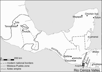
When Pedro de Alvarado arrived in 1524 in the Río Ceniza Valley (Figure 1) of modern-day western El Salvador, he met formidably large, well-equipped armies of the Izalcos Pipil. The Izalcos Pipil belonged to the Nahua linguistic group, which is made up of Nahual, spoken by groups in northwestern Mesoamerica; Nahuatl, the language of the Mexica or Aztecs and other groups of central Mexico; and Nahuat, whose speakers were scattered throughout much of southern Mesoamerica, including groups in Puebla and the Gulf Coast in Mexico, Guatemala, El Salvador, Honduras, and as far south as Nicaragua. Nahuat speakers in Central America were called pipil, an ethnic identifier that appears to be related to pipiltin “noblemen.” Nahua seems to have arisen in northern Mesoamerica and then spread southward. Linguistic evidence indicates that the Pipil pushed this dispersal even farther south, moving into the Río Ceniza Valley about the same time as Nahuatl speakers were establishing themselves in and around the Valley of Mexico (Kaufman and Juteson Reference Kaufman and Justeson2007:217; Luckenbach and Levy Reference Luckenbach and Levy1980; Smith Reference Smith1984). In fact, from the perspective of Mesoamerica as a whole, a.d. 1000 to 1250 can probably be thought of as a time of Nahua diaspora. Archaeological evidence indicates that the Pipil of western El Salvador, known as the Izalcos (los yçalcos)Footnote 1 were relative latecomers in this Nahua diaspora and brought with them an economic emphasis on the intensive production of cacao, a socially-encoded comestible and currency (Aguilar-Moreno Reference Aguilar-Moreno and McNeil2006; Martin Reference Martin and McNeil2006; Reents-Budet Reference Reents-Budet and McNeil2006). This economic focus on cacao production is not typical of Nahua groups at the time, which calls into question whether the Pipil followed Nahua traditions. Pipil linguistic affiliation with central Mexico is indisputable, but linguistic affiliation does not necessarily imply cultural continuity. Ethnohistoric and archaeological data presented below, however, suggest that the Pipil maintained distinctly Nahua social institutions.
Map of Mesoamerica indicating archaeological sites and zones considered in this study.

These Nahua institutions were challenged but not obliterated by Spanish conquest. Some Pipil cultural practices, such as cacao production and trade, presented irresistible opportunities to the Spanish. Numerous sixteenth-century documents extol the extraordinary wealth generated by cacao trade in the Izalcos region in the early Colonial period, and this wealth was a magnet for influential Spaniards, merchants, and traders (Bergmann Reference Bergmann1969; Browning Reference Browning1971; Escalante Arce Reference Escalante Arce1992; Fowler Reference Fowler and Thomas1986, Reference Fowler1987, Reference Fowler1989, Reference Fowler, Muñoz and Aguilar1994, Reference Fowler1995, Reference Fowler and McNeil2006; MacLeod Reference MacLeod1973). The post-contact importance of cacao suggests that the colonial economy was based as much on new tastes for and uses of native commodities as those imported from Europe. At the same time that the new commodity created a place of Spanish economic and political power, Spanish institutions were undermined by other Pipil practices. These conflicts and concordances form the core of the transformation of Pipil and Spanish institutions into a new colonial system.
One way to see how social life changed for both the Pipil and Spanish as a result of conquest is by examining how the organization of space changed over time. This archaeological approach assesses pre- and post-contact phenomena on an equal basis (Lightfoot Reference Lightfoot1995). Archaeological and ethnohistoric data show that both Pipil and then Spanish newcomers to the Río Ceniza Valley drew upon political, social, and economic traditions from their homeland to arrange their new living and working environments, but the new setting was not a perfect palimpsest. The changes in settlement structure from one time period to the next reflect a dynamic negotiation among tradition, new opportunities, and local cultural and environmental constraints on social, political, and economic processes. Understanding what changed and how changes and continuities affected social life requires a discussion of ethnohistoric and archaeological data related to spatial patterning and social institutions. These data show that Pipil social and political complexity depended upon free interchange and integration of dispersed elements, and this method of organization directly conflicted with Spanish emphasis on hierarchy, nucleation, and barriers to interchange. The early colonial political economy did not preserve pristine forms of either Pipil or Spanish institutions, but elements of each served to create a dynamic new system that made its mark on the world stage.
NAHUA CHARACTERISTICS OF THE IZALCOS PIPIL
The first realm of data considered here is ethnohistoric reconstructions of Nahua and Pipil sociopolitical institutions. The comparison of Lockhart's (Reference Lockhart1992) analysis of central Mexican characteristics with features of the Izalcos Pipil reported in Escalante Arce (Reference Escalante Arce1992) and Fowler (Reference Fowler and Thomas1986, Reference Fowler1987, Reference Fowler1989, Reference Fowler, Muñoz and Aguilar1994, Reference Fowler1995, Reference Fowler and McNeil2006) as well as my work in the municipal archive of Caluco, a settlement in the Izalcos heartland, underscores key commonalities that suggest Nahua ethnic affiliation.
The Nahua Nature of Pipil Political Economy
Contending that the Pipil maintained Nahua traditions is warranted on the basis of ethnohistoric understanding of the Nahua world. Lockhart (Reference Lockhart1992:10) argued that in Mexico “the Nahua world was in fact a unit in many respects, before and after the conquest. No other conclusion could be drawn, given the use of the same terminology and concepts in politics, kinship, and land tenure in random attestations across the whole region…” The scope of this similarity reaches well beyond Mexico because the same terminology and evidence of similar organizational principles are likewise found in the Izalcos region.
Lockhart (Reference Lockhart1992:15) refers to the underlying principle of any kind of Nahua organization as “cellular”:
[t]he Nahua manner of creating larger constructs, whether in politics, society, economy, or art, tended to place emphasis on a series of relatively equal, relatively separate and self-contained constituent parts of a whole, the unity of which consisted in the symmetrical numerical arrangement of the parts, their identical relationship to a common reference point, and their orderly, cyclical rotation.
This cellular principle extended to the fundamental and remarkably durable social, economic, and political construct for the Nahua, the altepetl or ethnic state (Lockhart Reference Lockhart1992; Schroeder Reference Schroeder and Harvey1991:160). The internal organization of the altepetl generated this cellular independence. The altepetl was subdivided into calpolli, and each calpolli held a section of the altepetl territory for exclusive use by its members (Lockhart Reference Lockhart1992:14, 16). This subdivision of resources helped create cellular organization through economic independence. The term calpulli appears in Izalcos documents (Fowler Reference Fowler and McNeil2006:312). Capulli is the most common spelling for this word in English and Spanish, while calpolli is the normal Nahuatl form and underscores that it is as an inanimate noun that does not show a plural (Lockhart Reference Lockhart1992:16). Here, I preserve the orthography of Izalcos-area documents. The use of the term calpulli in Izalcos documents demonstrates a link to Nahua political and organizational principles of the calpolli and may be emphasizing the Pipil peripatetic heritage (see also Browning Reference Browning1971:16). Schroeder (Reference Schroeder and Harvey1991:150–153) notes that calpolli refers to subdivisions of migrating groups such as the Mexica as they traveled from Aztlan and is a term parallel to chinamitl, tlaxilacalli, and calpultlaxilacalli. The latter two terms refer to a territorial organization, and chinamitl refers to a traveling group of people. Some Nahua texts use calpolli for the migratory phase and tlaxilacalli for the parts of an altepetl with a fixed territory (Lockhart Reference Lockhart1992:16). The use of calpulli suggests that the Izalcos seemed to have stressed not a fixed territory but instead their migratory flow.
Further subdivisions within the Izalcos altepetl are suggested by the distribution of encomiendas. Lockhart (Reference Lockhart1992:29) observed that “[o]ther things being equal, Spaniards in America tended to opt for the largest encomienda the indigenous structure could support, that is, to retain the largest viable indigenous units.” This pattern certainly holds true with the preservation of the division of Cuscatlan and the Izalcos as the Spanish jurisdictions of San Salvador and Sonsonate. Within the Izalcos region, the earliest references to encomiendas describe an altepetl pertaining to Izalco and another to Tacuscalco, but the encomiendas were further subdivided so that Izalco was divided into two encomiendas (Caluco and Tecpan Izalco) while Tacuscalco was divided into four (two in Tacuscalco and two in Nahulingo), and the San Julián Cacaluta area was included in a separate encomienda (Escalante 1992(1):220). Lockhart (Reference Lockhart1992:29) noted that altepetl sometimes had a sharp internal division that suggested a moiety structure (a division of society into two groups) that included duplication of political offices and distinct identities. Tacuscalco and Izalco perhaps had such sharply defined moieties that they could not be easily made into a single tribute-paying unit (see Lockhart Reference Lockhart1992:29). At the very least, this division of encomiendas probably presents a proportional distribution of riches.
The Nahua emphasis on symmetry and independence of the altepetl expressed itself on the landscape in evenly spaced settlements with an overall pattern of slight nucleation (Lockhart Reference Lockhart1992:19, Figure 2.1). Williams (Reference Williams and Harvey1991:205) found just such dispersed but discrete rural settlements under the jurisdiction of a large political entity in Tepetlaoztoc (Santa María Asunción) in the Valley of Mexico; dispersed settlement seems to have been typical in the Late Postclassic period in other regions of Mesoamerica (Kowalewski Reference Kowalewski, Fish and Kowalewski1990:61; Sanders Reference Sanders, Billman and Feinman1999:16). Documents regarding the Izalcos suggest that such a dispersed settlement pattern existed before Spanish conquest (Escalante 1992(1):218), yet several colonial sources also refer to Izalcos “towns,” especially the “four Izalcos” or principal named units of Izalco, Caluco, Tacuscalco, and Nahulingo (discussion in Sampeck Reference Sampeck2007:40–45; see also Pineda Reference Pineda1925:332, 336; Vázquez de Espinosa Reference Vázquez de Espinosa and Clark1942), suggesting settlement hierarchy. How well the Izalcos region conforms to typical Nahua settlement organization is not clear from documentary sources alone.
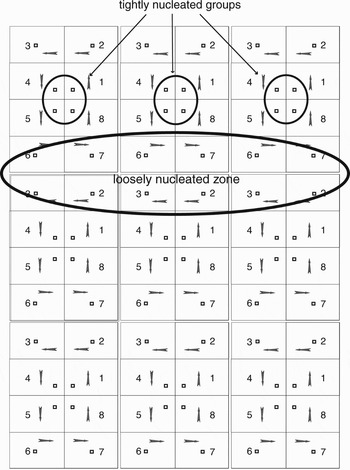
Nahua social emphasis on independence was reinforced by the tendency for settlements to disperse power, which plays havoc with archaeological interpretation of nucleation. Lockhart's (1992:Figure 2.1) idealized altepetl settlement structure symmetrically divides territory among eight calpolli, with a central cluster of the first, fourth, fifth, and eighth calpolli in rank and order of the cycle of rotating duties. The resulting agglomeration could resemble a city, but each subunit within this cluster retained its independent identity and functions. The highest-ranked calpolli do not form the inward cluster, but instead the seeming centralization of power includes the highest and lowest ranked calpolli. The important point is that nucleation in itself does not denote political dominance. If this pattern is repeated in a broader territory of multiple, adjacent altepetl, clustering would also be seen among the outer calpolli in adjacent altepetl (see Figure 2). This clustering near the upper and lower altepetl border is looser than the grouping at the center of the altepetl and includes the middle-low and middle-high ranked calpolli. The loose border clusters could be erroneously considered to be an entity separate from the tighter central cluster or dominated by the central cluster. Furthermore, an archaeological interpretation of political distinctions based on contrasting degrees of settlement nucleation would incorrectly lump together settlements from different altepetl by assuming that the loose border cluster represents a single entity, which also has the effect of divorcing outlying calpolli from their respective altepetl. This Nahua settlement pattern did not concentrate the upper tiers of the social, political, and economic hierarchy into nucleated groups as traditional archaeological models of nucleation assume, but instead distributed high-ranking groups in both the tighter and looser settlement groups, which reinforced cellular independence rather than centralization.
Multiple idealized altepetl. Note the contrast of tighter clusters in the center of an altepetl and looser clusters near the upper and lower borders.

This concept of place and space challenges archaeological assumptions about the importance of centralization in complex polity formation. Archaeologists place a strong emphasis on how nucleation reflects the number of levels in the administrative hierarchy and centralization at the uppermost level (Anderson Reference Anderson1994; de Montmollin Reference de Montmollin1989; Hally Reference Hally and Hally1994, Reference Hally, Billman and Feinman1999; Steponaitis Reference Steponaitis and Smith1978, Reference Steponaitis1981:321; Wright Reference Wright III and Earle1984). The aggregation of population into fewer and larger settlements is generally thought to demonstrate increasing political complexity, a perspective that has its roots in Childe's (Reference Gordon1950) “urban revolution” and is reinforced by the core-periphery distinctions of World-Systems theory (Stanish Reference Stanish, Billman and Feinman1999:127; Wallerstein Reference Wallerstein1974). Arguments regarding pre-Hispanic state-level production and distribution of wealth in Mesoamerica tend to focus on centralization of workshops rather than dispersed household production. Hierarchically organized civic/ceremonial systems are expected to display a regular, inverse relationship between size and number of centers, an even spatial distribution of centers of similar levels, regional styles of architectural design, congruence of features or style with hierarchical level, and congruence of functions with place in the proposed hierarchy (Kowalewski Reference Kowalewski, Fish and Kowalewski1990:69–70). If centralization is the key factor in complexity, then the dispersed Nahua settlement patterns would indicate they were not complex, or were at least weak (see Billman Reference Billman, Billman and Feinman1999:158), but every indication in the ethnohistoric record is that the Izalcos was a powerful, complex polity, as the Nahuas of central Mexico certainly were. Although the assumption has been that high degrees of centralization and differentiation occur in well-integrated political systems (de Montmollin Reference de Montmollin1989:134), it seems that the cellular Nahua system can generate well-integrated systems as well. Nahua organizational principles allowed dispersed settlement as the dominant pattern within a state-level society.
Two typical Nahua political institutions varied in how they relied on cellular principles of organization. In the eastern Nahua area of Mexico, the teccalli, the lordly house in which every tecutli (lord) was the head and every pilli (noble) was a member, functioned entirely outside the institutions of the calpolli and altepetl, so that calpolli members owned land and dependents of lords did not (Lockhart Reference Lockhart1992:106). In the western Nahua area of Mexico it appears that the tecpan (palace or “place where the lord is”) was integrated into the calpolli, so that the lord of the tecpan was also head of his calpolli, and the lord and his followers were one of several ward-like sets of people and land that composed his calpolli (Lockhart Reference Lockhart1992:105). In either case, the altepetl was a territorial unit in the sense that a group of people held sway over a given territory (Lockhart Reference Lockhart1992:14; Shroeder 1991:144–148), yet for the western Nahua, that control was administered through each calpolli of the altepetl and thus encouraged greater cellular independence. The use of tecpan to identify Izalco (Escalante 1992(1):233; Fowler Reference Fowler and Thomas1991, Reference Fowler, Muñoz and Aguilar1994, Reference Fowler and McNeil2006) may indicate that the Izalcos followed a pattern like that of the western Nahua of Mexico with the more integrated form of lordly houses. This similarity in political and social organization may indicate either a shared heritage with western Nahua groups or analogous cultural processes that resulted in a similar emphasis of the institution of the tecpan.
Although Nahua sociopolitical organization reflects important decentralizing tendencies, elements of centralization did exist and played significant roles. One centralizing tendency in Nahua organization was the tlatoani or king who was the primary reference point for the calpolli and the embodiment of the altepetl (Lockhart Reference Lockhart1992:18). Rotation of duties among the calpolli, another centralizing force for the altepetl, was most evident in services performed for the tlatoani. Nobles from all the calpolli paid court to the tlatoani at his tecpan (palace), and commoners rotated in service there as well. The tlatoani taxed and regulated the market, another focal point for the altepetl. Another impetus for centralization was focused upon the temple and its ethnic god. The priesthood, composed of nobles often closely related to the tlatoani, was in charge of the temple (Lockhart Reference Lockhart1992:18). Duties rotated among the calpolli for service to the temple just as they did for service to the tlatoani. The temple was the focal point of ritual activity for all calpolli equally. Despite the centralizing forces of the office of the tlatoani, the market, and the temple, the fundamental structure of the altepetl was unitary. Each calpolli held territory for the sole use of its members, and the tlatoani was always a member of an individual calpolli. The tlatoani's calpolli was always the highest ranking within the rotational order, and he served as teuctlatoani (calpolli leader) as well. Thus, the centralizing institutions were firmly embedded within the smaller constituent parts of the altepetl, placing a priority upon the cellular structure rather than centralization. The cellular nature of the altepetl created durability and flexibility that allowed some pre-Columbian altepetl to persist relatively intact well into the colonial period and provided the organizational matrix within which the Spanish imposed more European forms (Lockhart Reference Lockhart1992:20, 26–27, 29; see also de Montmollin Reference de Montmollin1989:27; Flannery Reference Flannery1972).
Because symmetrical relations and, at times, fierce independence rather than centralization were the dominant modes of organization, discontinuous or interpenetrating territory becomes logically possible (Lockhart Reference Lockhart1992:17, 20). The domain of any subunit did not have to be in immediate physical proximity or could be interspersed with other subunits because the mechanism of political relationship was through the cyclical flow of duties among the calpolli and the symmetrical relationships of each subunit to the others. Discontiguous territory seems to explain best the anomaly of the settlements of Nahuizalco and Mazagua (Santa Catarina Masahuat) in the western side of the Izalcos region. Ethnohistoric evidence indicates that these settlements embedded well within the Izalcos zone were considered part of the adjacent polity of Cuscatlan in central El Salvador, and tribute from these areas mirrored commodities and amounts characteristic of Cuscatlan rather than the Izalcos (Fowler Reference Fowler1989:152–191).
At a smaller scale, this notion of integration over discontiguous space is also present in the Nahua concept of the callalli, (“house-land”), which does not correspond exactly to “household” but is a more inclusive term that can be thought of as the domestic realm. The term is more inclusive because it refers to not only several buildings (including the household) and adjacent orchards or gardens, but also to affiliated agricultural lands that could be some distance from and not directly adjacent to the domestic structures (Lockhart Reference Lockhart1992:68–69). The household was dispersed on the landscape, and distinctions were not made between the domestic structures versus agricultural land, just as the nucleated settlement within the altepetl was not thought of as distinct from its associated lands. This point will be discussed further to interpret excavation data presented below.
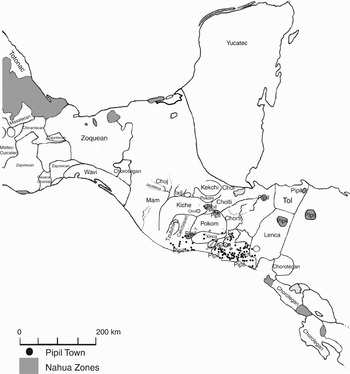
Discontiguous territory and the independence and cellular nature of altepetl seem to be writ large on the landscape by the overall pattern of Nahua settlement in southern Mesoamerica. The flexibility of the altepetl structure allowed incorporation of groups of foreign ethnicity into the political and economic system by means of calpolli formation, yet identity was not sacrificed (Lockhart Reference Lockhart1992:17). Similarly, Pipil enclaves located in non-Nahua zones seem to have maintained their Nahua identity. Pipil Contact-period towns occurred from southern Mexico to lower Central America in solidly Maya zones near the upper Motagua and Pasión drainages, in an ethnic patchwork along the Pacific coast of Guatemala, and in areas occupied by the Lenca and other groups in Honduras and Nicaragua (see Figure 3). The Izalcos, coastal Guatemala, and central El Salvador were unusual in that the Pipil controlled large tracts of land, but the population was not necessarily ethnically homogeneous. Documentary sources are clear that the Pipil controlled the south coast of Guatemala and most of El Salvador at contact (Fowler Reference Fowler1989), but Alvarado seems to have encountered non-Maya, non-Pipil populations between Pan Atacat (Esquintla) and Acajutla. Barón Castro (Reference Barón Castro1950:21) does not give a citation for this information, but he states that Alvarado crossed the “reduced” territory of the Xinca at the banks of the Río Paz and then entered territory that was “newly” Nahua.
Map of the distribution of Nahua speakers and Pipil towns at contact. Linguistic boundaries after Fowler (Reference Fowler1989), Miles (1957), and Longacre (1967:Figure 15).

The designation of some of these settlements as Pipil is a matter of debate, partly because it seems illogical for such settlements to be located within territories of other ethnicities. These “Pipil” towns could have been entirely under the control of the local population but included a significant Pipil population. For example, it is unclear whether Pan Atacat (Escuintla), which controlled access from the highlands to the Pacific coast, was Pipil at Spanish contact. No documents refer to them as Yaki (a term used by Mayans for Nahua speakers), but the hostile relationship recorded between the Kaqchikel and the inhabitants of Pan Atacat and/or Escuintla during the entrada of Pedro de Alvarado in 1524 strongly suggests that the residents of this region were indeed Pipil (Alvarado Reference Alvarado and Mackie1924[1525]:74–75; Maxwell and Hill Reference Maxwell and Hill2006:263–264; Orellana Reference Orellana1995:26; Polo Sifontes Reference Polo Sifontes1979:32; Recinos and Goetz Reference Recinos, Goetz, Chonay and Goetz1953:122–123). Some sources do not specifically state that the Izalcos were Pipil, but many others do, sometimes through references by central Mexicans to a shared heritage (Ixtlilxochitl Reference Ixtlilxochitl1975:489; Motolinia Reference Motolinia1908:9). Part of this heritage appears to have been the ability to exist in enclaves, an extension or elaboration of Nahua principles of cellular independence.
Pipil settlement in southern Mesoamerica was not a far-reaching land grab but a control of precise points along trade routes—not a control of large tracts of land, but of the landscape. These settlements were optimally located along prime points of control, such as headwaters, crossings, and passes (see Earnest Reference Earnest1999). Sharer and Sedat (Reference Sharer and Sedat1987:22–24) provided detailed analysis of travel routes in the Salamá Valley, another locus of Postclassic period Pipil activity, and showed the variety of resources accessible by these routes. Sharer and Sedat (Reference Sharer and Sedat1987:449) argued that long-distance exchange had to be well-organized, managing portages and negotiating alliances, and they conclude that “earlier studies have underestimated the prevalence and duration of Precolumbian travel and interaction between regions …” If these isolated Pipil towns had a managerial function focused on maintaining trade, they would not have presented an overt political threat but instead an orderly extension of the Late Postclassic exchange network. This exchange network is indicated by features such as trading posts like those historically known in the Peten lakes area (Jones et al. Reference Jones, Rice and Rice1981:534), which provided the infrastructure and services necessary to maintain established routes of travel. Pipil involvement in the maintenance and integration of this far-flung network fits logically within the Nahua cellular, discontiguous political economy that did not require nucleated, primate settlements but did emphasize orderly flow.
If the Pipil were primarily negotiating pinpoint control of an established trade route, then why did they also occupy the extensive tracts in coastal Guatemala and central and western El Salvador? In this case, the goal may have been to control trade, particularly in cacao. As Fowler (Reference Fowler1989, Reference Fowler and Thomas1991) has shown, the intensive and prodigious cacao production of the Izalcos does not appear to have been an entirely colonial phenomenon; rather, the Spanish appropriated and intensified an extant system. Most sources agree that tribute levels in the Izalcos, particularly the four principal named entities of the Izalcos, Izalco, Caluco, Nahulingo, and Tacuscalco, greatly exceeded tribute requirements in other parts of the Audiencia of Guatemala or in New Spain (Escalante 1992(1):247, 255). The first tribute assessments of the Izalcos region were conducted by the Bishop Marroquín in 1538. Marroquín set the tribute due from Izalco at 1,000 xiquipilli of cacao, painted cloth and white cloth, salt, wax, honey, chickens (gallinas de tierra and de castilla), plus 15 fanegas of corn (Escalante 1992(1):219). Considering that Marroquín emphasized tribute in commodities familiar to the Spanish (salt, wax, and honey), the tribute in cacao is high and suggests that production was already abundant (Gall Reference Gall1968). Strong economic incentives appear to be central factors in the location of Pipil settlement in southern Mesoamerica, either through managing trade or production of one of Mesoamerica's most lucrative commodities.
Ethnohistoric evidence has shown that in some cases, the Nahua nature of the Izalcos Pipil was expressed through similar terminology and organizational concepts. Pipil settlement distribution, however, seems to indicate a heightened emphasis on discontiguous methods of integration and optimal trade routes as well as the uniquely Izalcos Pipil reliance on cacao production. These typically Nahua and distinctively Izalcos Pipil elements are further underscored by the archaeological investigation of changes in the use of space.
COMMUNITY INTEGRATION IN THE ALTEPETL OF THE IZALCOS
The Río Ceniza Valley, the heartland of the Izalcos polity, contains many ecological zones (Fowler Reference Fowler1989: Figure 13.1), and this region formed an extended “gateway community” (Hirth Reference Hirth1978) that controlled an optimal route between Guatemala and lower Central America. The approximately 216 km2 region was inspected, and about half was intensively surveyed, yielding a little over 2700 ha with Postclassic or Colonial period activity. Special attention was paid to “non-site” cultural features of organization and integration in the human landscape that helped control human traffic and trade, such as roads, fords, and relict irrigation canals (Nieves Zedeño and Stoffle Reference Nieves Zedeño, Stoffle, Rockman and Steele2003:60, 63–64).
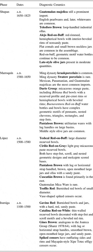
The chronological components were determined by diagnostic pottery types (see Sampeck Reference Sampeck2007). A summary of these chronological phases is presented in Table 1. The Irarrága phase represents the Late Postclassic, while the López phase includes the Conquest period. The early fully Colonial period coincides with the Marroquín Phase, while the late Colonial period is designated by the Shupan Phase. Regional survey was complemented by excavations of structures in eight survey areas that examined architectural form and construction history as well as associated subsurface features. Sites were nonrandomly selected for test excavation to investigate domestic and nonresidential structures appearing to date to the Irarraga, López, and Marroquín phases. These excavations included complete excavation of an Irraraga phase ceremonial temple and several Irarraga, López, and Marroquín phase domestic structures.
Late Postclassic and Colonial Period Phases of the Río Ceniza Valley

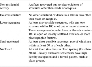
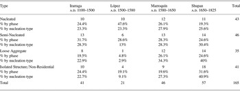
Sites in the Río Ceniza Valley were assessed for nucleation by basic criteria presented in Table 2 to see if settlement of any time period had characteristically Nahua de-emphasis of nucleation. This taxonomy does not assume that any one type implies a particular function or social environment but does recognize variation along a continuous scale of nucleation. Furthermore, the standard for nucleation is not high, with a grouping defined by a minimal number of structures. The overall tendency in Izalcos settlement before and after conquest was for nucleation balanced by dispersion (see Table 3).
Nucleation Types for Settlement in the Río Ceniza Valley

Counts and Percentage Frequencies of Nucleation Types

One underlying cause for the consistency in settlement pattern may be pre- and post-contact emphasis on cacao cultivation. Cacao almost certainly was grown in the region prior to the arrival of the Pipil, but the highly intensive cultivation by the Izalcos was unusual in Mesoamerica. Cacao cultivation does not favor nucleated nor overly dispersed settlement. By all accounts, the consistent, demanding labor required to maintain cacao orchards provided an impetus for nucleation. The fragile trees as well as acequias (irrigation canals), however, needed regular care, so distant settlement, either nucleated or highly dispersed, would not be advantageous. Thus, the most favored arrangement would be loosely agglomerated settlement adjacent to or in agriculturally rich land with sources of water. This environmentally-based model explains basic patterning, but the dispersed Nahua pattern has been found in diverse ecological settings and a range of kinds of economic production in central Mexico and the great productivity of cacao cultivation in the Río Ceniza Valley underscores a contrast with environments in much of central Mexico. The persistence of the Nahua settlement pattern in the Río Ceniza Valley may have been reinforced by ecological and economic conditions, but the reason for the pattern to emerge in the first place appears to be most related to Nahua methods of cultural organization.
These Nahua characteristics of the Irraraga phase were something new to the Río Ceniza Valley. Late Postclassic site location and artifact assemblages show no continuity with that of the earlier Terminal Classic/Early Postclassic periods. The identification of the Early Postclassic has been problematic in adjacent areas of the Guatemalan coast and has reached as far as Chiapas. Voorhies (Reference Voorhies, Bove and Heller1989:123) proposed that the problem lay in defining diagnostic ceramics rather than tremendous depopulation. The evidence in the Río Ceniza Valley, however, indicates that dramatic depopulation did occur at the end of the Late Classic, and Terminal Classic/Early Postclassic patterns of artifact manufacture and site location showed strong linkages to the Late Classic, but the overall numbers of sites were very low (Sampeck Reference Sampeck2007). Thus, the Pipil appeared to have moved into a relative void. The arrival of the Pipil in the Late Postclassic was coincident with an upsurge in population and entirely new systems of settlement and artifact manufacture.
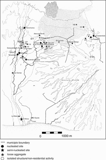
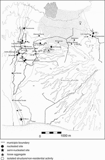
Within this overall consistency in settlement pattern are subtle variations that relate to important changes in the political economy of the valley. Region-wide frequencies, represented by percentage frequencies by either settlement type or phase, indicate a generally dispersed settlement pattern in the Late Postclassic period Irarraga phase (Figure 4). The different nucleation types were evenly distributed, but seminucleated settlement occurred slightly more frequently. Loose agglomerations rather than isolated structures were the most common form of dispersed settlement. Relatively equal proportions of isolated structures before and after conquest in the Izalcos region may also suggest some degree of confidence in the ability to live in isolation. The tendencies of the altepetl for centralization and dispersal seem to be balanced. The slight tendency toward agglomeration may relate to the corporate nature of organization—that all inhabitants are members of a calpolli within the altepetl and that resources and work are regulated within this social group.
Irarraga phase settlement in the Río Ceniza Valley.

The Late Postclassic cellular pattern observed in the Río Ceniza Valley is not an isolated occurrence. A similarly dispersed pattern seems to occur in Pacific coastal Guatemala. All of the Late Postclassic regional centers along the Pacific Guatemalan coast are of similar size and characteristics, and no Late Postclassic regional center along the Guatemalan Pacific coast was fortified (Bove Reference Bove, Love, de Hatch and Escobedo2002:205). This contrasts sharply with the adjacent highlands, but Bove (Reference Bove, Love, de Hatch and Escobedo2002:205) cautioned that “whether the lack of defensive works indicates a more peaceful existence compared to the highlands remains to be proved.” Nahua settlement and attendant social institutions may have extended from the Izalcos region to Pacific coastal Guatemala, whereas fortified sites were more characteristic of Highland Maya and other groups who emphasized centralizing social institutions. The lack of defensive works may also indicate that the coastal centers controlled interaction in this broad zone, creating accessibility that fostered commerce. This settlement evidence suggests that the Izalcos integrated exchange network may have included the Guatemalan Pacific coast. So, even though the Izalcos polity seems largely confined to the survey zone, some degree of cultural and economic alliance may have existed with Guatemalan coastal settlements.
In the short term, the Spanish Conquest appears to have turned the established Izalcos settlement pattern on its head (Figure 5). López phase sites were fewer than in the previous phase, probably indicating depopulation due to disease, warfare, and difficult living conditions associated with conquest, and the sites that existed contracted into nucleated centers. According to the distribution of percentage frequencies by nucleation type, isolated structures were least common in the López phase. Likewise, the minor degree of settlement nucleation in the form of loose aggregates and semi-nucleated settlement was rare in the Conquest period. Loose aggregates could have been potentially the most dangerous of all settlement forms because the slightly closer spacing of structures may not have provided any added security but instead may have made a large area vulnerable. The small proportion of isolated structures in the López phase in combination with the distribution pattern of nucleated settlements on hilltops suggests a collective flight to defensive locations in the hills in the face of Spanish intrusion. This reaction stands in contrast to patterns observed elsewhere, such as the Lake Peten Itza vicinity, where increasing retrenchment in reaction to a growing Spanish threat in the seventeenth century took the form of a gradual evacuation of centers (Jones et al. Reference Jones, Rice and Rice1981:544). Both the Itza and the Izalcos resorted to the inverse of their previously established settlement pattern.
López phase settlement in the Río Ceniza Valley.

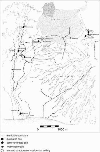
After the Spanish established themselves on the landscape in the Marroquín phase, the cabecera model of settlement, with a hierarchy of towns that reflected political importance, emerged but did not override the tendency for loose aggregation of the Nahua system (Figure 6). Percentage frequencies by nucleation type indicate that nucleated settlements occur in nearly equal frequency in the different phases, but greater nucleation occurs in the Marroquín period, which seems to reflect the widespread implementation of the policy of reducción before the dominance of the hacienda mode of production. Nahua modes of organization made a resurgence, probably due in part to rebounding population after the initial shock of conquest and the worst excesses of tribute requirements. The slight preference in the Marroquín phase for semi-nucleated settlement, shown by percentage frequencies by phase, may have also been a balancing act between Spanish ordinances for nucleation and the need for dispersed settlement to tend cacao orchards. Thus, the early colonial pattern, established after the chaos of the Conquest period, does not show a complete dominance of Spanish modes of settlement, but rather elements of both systems.
Marroquín phase settlement in the Río Ceniza Valley.

By the Shupan phase, the highly dispersive tendencies of the hacienda system outweighed the centralizing force of the cabecera system or the loose agglomerations of the Nahua system. The dominance of the countryside and highly scattered settlement of the Shupan phase may also have been in response to the rise of more decentralized methods of political control (Escalante 1992; MacLeod Reference MacLeod1973), which hearkens back to Nahua systems. Yet the mode of independence appears to be centered on individual independence rather than the corporate independence of the calpolli within the altepetl. The high proportion of isolated structures in the late eighteenth and early nineteenth century also suggests an increasing emphasis on private land ownership that may have coupled with increasing “ladinization” of the countryside (Escalante 1992; MacLeod Reference MacLeod1973). In this case, decentralization was generated by a widening range of populations participating in an entirely different political economy, capitalism predicated on individual accumulation.
POLITICAL AND SOCIAL BORDERS IN THE IZALCOS LANDSCAPE
The spaces between sites can be as revelatory of social, economic, and political organization as the presence of the sites themselves. Gaps in the thin but consistent veneer of cultural materials in the survey region were rare but noticeable. It was surprising to discover that settlement zones on the same landform showed significant breaks. The most significant break in human activity occurs in the San Julián Cacaluta pocket, on the eastern edge of the survey zone. The lack of Postclassic period occupation in much of the San Julián Cacaluta pocket suggests a no-man's-land between Tamagás Mango on the west and La Camandula and La Roberta on the east, a gap that extended as far north as the northern edge of the territory mapped in Figure 5. This area is fertile and well-watered and was occupied in the Preclassic and Classic periods, so the underlying cause for the Late Postclassic cultural activity gap does not seem to be due to limitations in the natural environment. Further evidence reveals that after Spanish appropriation of these lands for haciendas, the San Julián Cacaluta pocket was resettled by loose aggregates of buildings oriented around the casco (main house) of the hacienda. Another large break in settlement occurs in the southern portion of the survey area north of Tonalá. This gap in settlement appears to be due to physiographic factors because the zone is a badlands of infertile heavy clay soils and poor drainage, and no artifacts or cultural features of any period were recovered there.
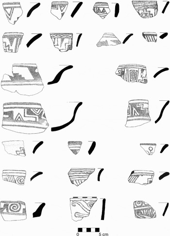
Whether the reason for the settlement gap was cultural or natural, cultural patterning on either side of these buffers was significantly different. For example, the Cuscatlán Brown ceramic group, found principally in the Tonalá and La Camandula zones, includes bowls with distinctively shaped tripods (Sampeck Reference Sampeck2007:406–410). Catalina Red-on-White bowls of the Izalcos heartland do not have tripod supports and emphasize red geometric decoration (Figure 7). The large, nucleated sites of La Camandula, El Mono, and La Batea, which form formidable barriers at the periphery of the Izalcos zone, are a striking contrast to settlement within the Izalcos, where settlements do not have a defensive character and are largely dispersed. Both of these areas of gaps bordered by large, nucleated centers are also critical points in the flow of traffic from the Guatemalan coast toward lower Central America: the Tonalá zone is the final plain before the impassable Balsam Coast, a place where traffic is forced northward toward the heartland of the Izalcos, and La Camandula sits at a critical pass for continuing east on this main route between Guatemala and eastern El Salvador. This route was designated part of the camino real in colonial times.
Catalina Red-on-White motifs and rim modes.

These contrasting zones separated by large buffers appear to delineate the division between the polity of the Izalcos and that of Cuscatlan. The Pipil of Cuscatlan may have had a different Nahua heritage and political and economic history that resulted in a greater emphasis on nucleated settlement than is observed in the Izalcos. The division between Cuscatlan and the Izalcos persisted in the Colonial period in the division of the parishes and jurisdictions of Santiago de Guatemala and San Salvador. Before naming the alcalde mayor of La Santísima Trinidad de Sonsonate in 1556, the Crown defined and extended the jurisdiction of Sonsonate to the border of the jurisdiction of San Salvador. Thus, the jurisdiction of Sonsonate extended from the Río Paz to the Tonalá coast—including the zone of Ahuachapan and the Izalcos—and north to the plain of Apaneca, but the Tonalá coast remained in the jurisdiction of San Salvador (Escalante 1992(1):44). A 1560 document from the real audiencia to the Crown suggested that the territory of San Salvador also be administered by the alcalde mayor of Sonsonate, an idea rejected by the Crown in favor of leaving alcaldes ordinarios in San Salvador and San Miguel (Escalante 1992(1):43). This action prevented the accumulation of too much power in Sonsonate. So, the jurisdiction of Sonsonate remained coincident with the territory of the Izalcos only and was not allowed to include or otherwise dominate Cuscatlan territory.
Even though the boundaries of the polities were maintained in the Spanish system, the centers of population did not persist, and former buffer zones became populated. The large, nucleated Irarraga and López phase Cuscatlan polity sites of La Camandula, El Mono, and La Batea, which formed impediments at the Izalcos periphery, declined to hamlet-sized populations in the Marroquín phase. The San Julián Cacaluta no-man's-land likewise became populated in a dispersed manner, and control of the pass for the camino real to the east and San Salvador shifted slightly southward from the depopulated La Camandula to Hacienda Los Lagartos. These changes in settlement organization suggest that the meaning of pre-Hispanic boundaries shifted as the colonial system matured.
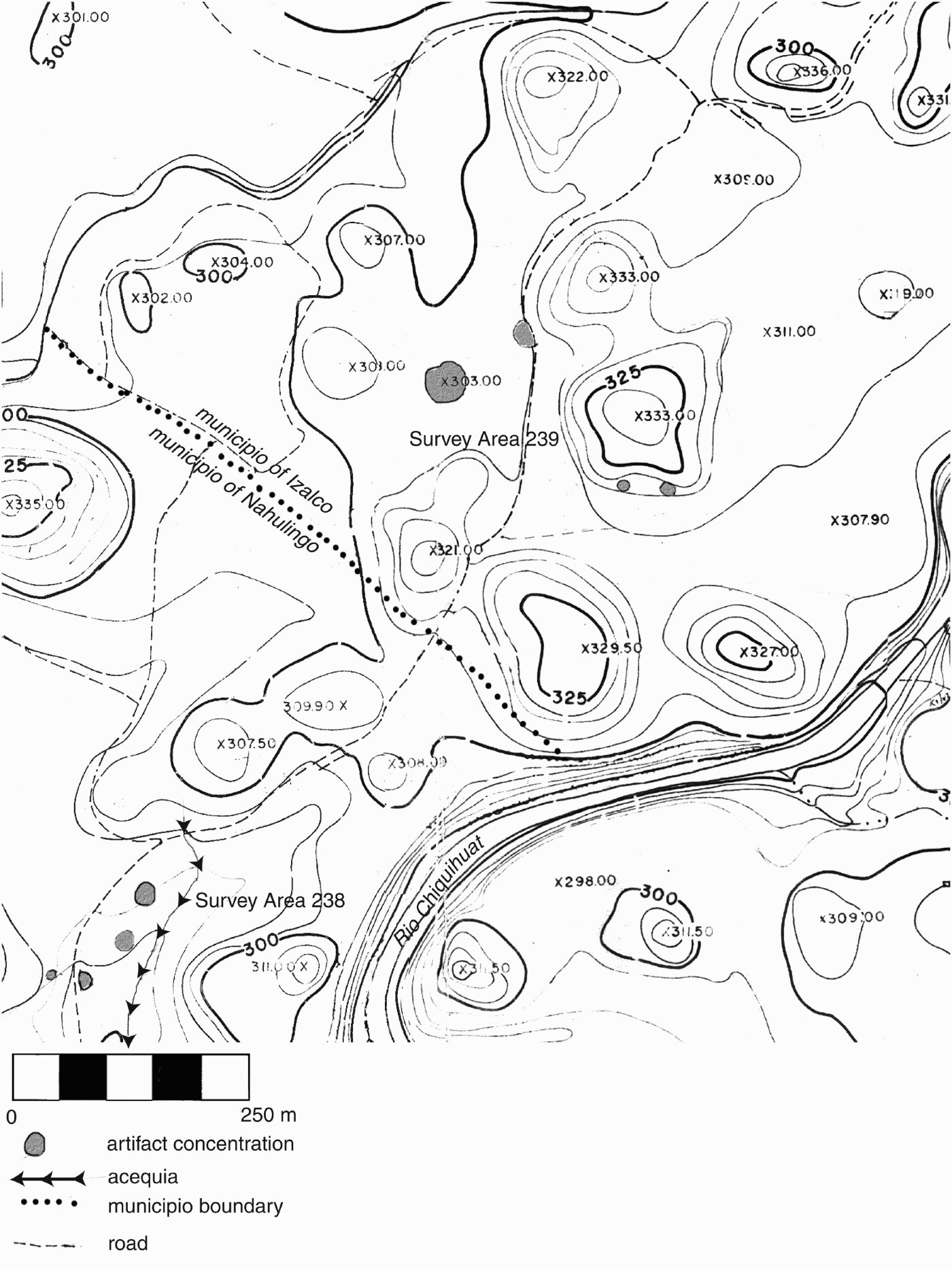
Just as the divisions between the Izalcos and Cuscatlan polities were suggested by gaps in the occurrence of artifacts, the divisions within the Izalcos region is shown by more limited gaps. For example, in the El Jícaro/Survey Area 238/Survey Area 239 zone, the contemporaneous settlement zones of Survey Area 237 and 238 occupy the same landform and do not have any clear physiographic or ecological reason for a break in settlement, yet a significant gap in artifact and structure density exists between the two areas (Figure 8). Tacuscalco, Tatopa, La Camandula, and Tecuma all occupy borderlands and are some of the most significant Late Postclassic activity zones. The absence of physiographic discontinuities along these boundaries suggests that underlying causes for settlement gaps and clusters may be in part political and follow Nahua cellular organizational principles, which generates loose clustering along border areas, as discussed above.
Map of Survey Area 239 and northern Survey Area 238.
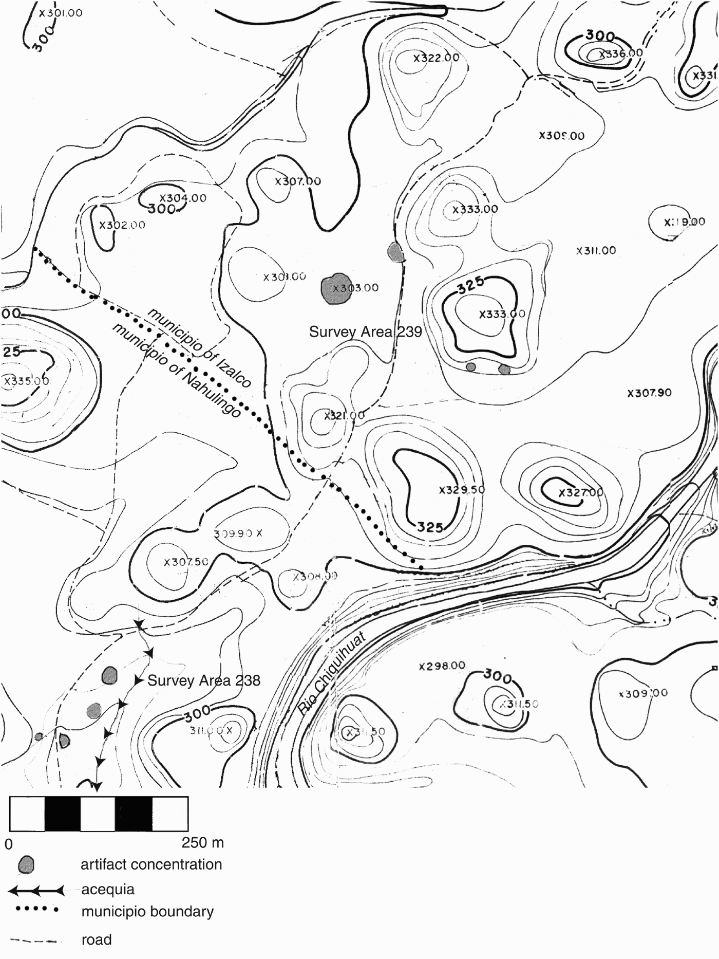
These pre-Hispanic intra-Izalcos discontinuities were maintained in the Colonial period through the creation of municipio boundaries, as the same gaps in Irarraga, López, and Marroquín phase settlement occur precisely along the municipio border. Lockhart (Reference Lockhart1992:45) noted that in Mexico a wave of congregaciónes (forced nucleated resettlement) took place in the 1550s, but “it is obvious that the essential distribution of altepetl and calpolli remained untouched.” A similar preservation of pre-Hispanic political boundaries appears to have taken place in the Izalcos. The work of Hill (Reference Hill1991, Reference Hill1996) and Hill and John Monaghan (1987) in the Guatemalan highlands, including the regions of the Chajoma and Kakchiquel, demonstrates that molding of the Spanish system by extant political boundaries was not unique to Nahua zones in Mesoamerica.
Even though Spanish practices maintained many elements of the Izalcos political economy, the policy of reducción, or resettlement into nucleated towns, fundamentally changed the Pipil social world. Lockhart (Reference Lockhart1992:45) claimed the impact of reducción on local populations was minimal because such settlements were usually the incorporation of a formal Spanish-style cabildo (municipal council) into an altepetl and that the resettled populations were mostly nobles from the hinterland. Indeed, the evidence presented thus far indicates that reducción did not change rates of nucleation as dramatically as conquest did. The conceptual shift of recognizing a city apart from the rural hinterland as well as a settlement hierarchy through the use of the terms cabecera and sujeto, however, seems to represent a profound reorganization of the experience of the landscape. This question of conceptual reorganization is not well answered by overall rates of nucleation because very different forms of social integration could be generating nucleated sites. Differences in underlying social practices can be investigated by examining details of the freedom of movement, the degree of integration in the landscape, and the kind of network formed by the organization and composition of sites.
Dell Upton (Reference Upton, Kelso and Most1990) addressed issues of mobility on and integration of the landscape in a comparison of the vernacular landscapes of slaves and poor white farmers versus the landed gentry in mid- to late eighteenth-century Virginia. Upton identified “articulated” or dynamic versus “disarticulated” or static conceptions and experiences of the landscape. These were two ways of conceiving the same landscape that largely depended on social class and power in the racialized social hierarchy of eighteenth-century Virginia. This approach highlights that the experience of the landscape was context-driven, complex, and guided by multiple principles. The gentry landscape was experienced dynamically because its meanings could not be comprehended at a glance. Instead, the observer was required to move through space and piece together many partial signals, forming a flexible, continuous system whose parts were sequentially related in space and time (Upton Reference Upton, Kelso and Most1990:75). Features of hierarchy, movement, height, and distance organized the built environment and the experience of the landscape so that structures and the roads that linked them formed an articulated spatial network (Upton Reference Upton, Kelso and Most1990 75–76). The network was flexible because the network of partial signals could be manipulated by the informed: “the manipulability of a landscape broken into many small, related, but carefully distinguished parts is evident in everything from household goods to fence types and field patterns” (Upton Reference Upton, Kelso and Most1990:80).
In contrast, the contemporaneous landscape of the “poorest white planters and, preeminently, of slaves, the same structures, along with slave quarters, woods, fields, and informal gathering places, appeared as a ragged patchwork of free and controlled spaces, one that was neither systematic nor particularly coherent” (Upton Reference Upton, Kelso and Most1990:72–73). Instead of presenting a manipulable network through which the observer moved, this landscape was organized as a series of landmarks “where customary social relationships are in effect, where control and possession are present, and where they are not” (Upton Reference Upton, Kelso and Most1990:74). Locks and carving on fenceposts were examples of the assertion of some control by slaves (Upton Reference Upton, Kelso and Most1990:74). This stress on articulation and mobility is helpful to contrast landscapes at different times. In the case of the Izalcos, the examination of mobility on and articulation of the landscape highlights fundamental differences over time of political, social, and economic organization that are not easily discerned on the basis of degrees of nucleation alone.
THE LATE POSTCLASSIC NAHUA ARTICULATED LANDSCAPE
Late Postclassic Izalcos settlement structure appears to exhibit many of the characteristics of an articulated landscape. Evenly dispersed structures within each bounded region—rather than the structured access nucleated centers create—is suggestive of relatively unfettered access for altepetl members. Throughout the survey area, the surface appearance of structures usually amounted to little more than a group of cobbles in a plowed cane field, so orientation and function were often difficult to determine. Excavations, however, revealed that prime functions were not embedded in nucleated centers. Both the location and function of structures suggests that the articulation of the landscape in the Irraraga phase was dependent upon free movement.
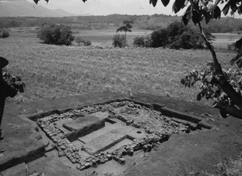
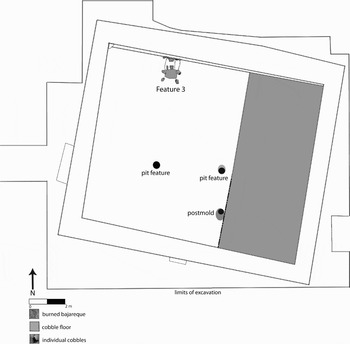
The best example of free access to a prime function is Structure 1 at Survey Area 18. Before excavation, this structure appeared to be a low (2m tall) mound. Excavation of this unimpressive mound revealed a surprisingly well-preserved temple (Figure 9). The large open-air platform suggests a public space. The cobbled floor of the superstructure defines a more private space that probably had bajareque walls and a thatch roof. No internal divisions of the superstructure were detected. The orientation of the building was to the west-northwest, indicated by the stairway, and secondary access was from the south (Figure 10). This architectural plan contrasted with excavated domestic structures of the same period, which were not constructed on a raised platform, but in two cases a cobble floor likewise defined the roofed space. Domestic structures were typically adjacent to middens or trash pits and in one case, an urn burial. All architectural features of Structure 1 suggest a largely public space.
Structure 1 at Survey Area 18 after excavation. View to northeast.

Plan drawing of excavations of Structure 1, Survey Area 18.

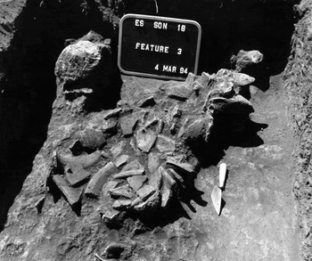
The presence of a ceremonial cache (see Figure 11) indicated the function of this structure as well. This was the only cache to date that was indicative of the use and/or construction of the temple. Several partial vessels (mostly censers) were smashed into an ellipsoid area on the north side of the platform. The feature resembled an altar because the north wall and the floor were faced with small cobbles, and feature contents had been burned, as indicated by large pieces of burned bajareque, fire-cracked rock, and an ashy matrix.
Feature 3, a dedicatory cache of broken censers in Structure 1 at Survey Area 18. View to south.

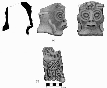
Whether the feature was installed with original mound construction or after the structure was already in use, the function of the feature was dedicatory. The contents of the cache exhibited three characteristics: (1) they contained a variety of censers; (2) all of the vessels were incomplete; and, (3) the remains were placed in a prepared cist. The other types of vessels in the cache were small bowls that may have been containers in a ritual setting (cf. Deal Reference Deal1982:627). The censers were small spiked censers, a monkey effigy, and a Mayapan-style censer with an applied Xipe Totec effigy (Figure 12). These different elements may point to a series of stages or elements in one ritual such as tlacaxipehualiztli, or a series of rituals that are functionally and/or mythologically related. Tlacaxipehualiztli was the springtime festival of flayed skins in which “owners” loaned out their flayed skin (presumably from a captive or sacrifice victim) on a daily basis to Xipe Totec impersonators who circulated throughout the settlement to receive alms and bestow blessings for 20 days (Barnes Reference Barnes2003). Because the cache vessels were incomplete, the vessels were possibly broken outside of the cist and then were gathered and placed in the prepared cist and burned. The placement of the cache in a prepared cist evokes the setting of an important burial.
Unspecified Censer from Feature 3, Str. 1 at Survey Area 18. (a) monkey effigy. (b) Xipe Totec foot from Mayapán-style censer.

A temple in the survey region was expected, but its setting was not. It was surprising that one of the only mounded Irarraga phase structures in the Río Ceniza Valley had no nearby settlement. A major highway was being constructed in this area at the time of this archaeological project, and the area immediately adjacent to the temple was cleared of the first 30 cm of soil as part of the highway construction, which was a sufficient depth to remove almost all of the soil in this zone. No buried structures or subsurface features were noted. The closest structures, a group of three small domestic structures, were over 100 m away. All evidence indicates that this temple was isolated.
The lack of elite dwellings in the immediate temple vicinity seems to emphasize the independence of the altepetl and calpolli because no physical impediments limited access to the temple. The Izalcos landscape appears to have been broken into many small, related, but carefully distinguished parts. This settlement pattern suggests a dynamic landscape everyone had to move through to complete basic activities. Everyone, regardless of rank, had to move through the landscape to use the temple. Ritual activity did not need to be embedded in a capital because it was so deeply integrated into the landscape. This spatial network was also one of pervasive power. The ruling hierarchy could maintain control without the immediate presence of elites at the temple. Political and social unity may have existed not because everything was centered in a single place, but because it was not, so that all the elements of social, political, and economic life—the callalli, the calpolli, and the altepetl—were maintained by the journey through the Izalcos landscape.
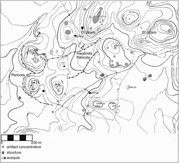
This hyper-articulated landscape began to change with Spanish conquest. Nucleation frequencies discussed above showed that López phase settlement was more limited and largely nucleated, but analysis of the organization of settlements shows that Nahua principles were maintained in many ways. The well-preserved site of Pancota had a ceremonial precinct of elevated substructures and range structures arranged around a plaza and areas of domestic habitation arranged in paired, terraced lots on nearby hilltops (Figure 13). These constructions date to the López phase only. The plaza arrangement on a hilltop physically controlled access, yet the ceremonial structures still did not appear to have immediately adjacent elite settlement, so control was not reinforced by physical proximity. This site plan seems to be a condensed version of the Irarraga landscape, with settlement constricted to a much smaller area in a defensible location. The regional landscape began to be fractured by the conquest-induced contraction in settlement, nevertheless the internal organization of these small zones distilled coherent articulation of the built environment on a small scale and thereby preserved the dynamic pre-Hispanic landscape.
Map of Pancota and vicinity.

THE COLONIAL DISARTICULATED LANDSCAPE
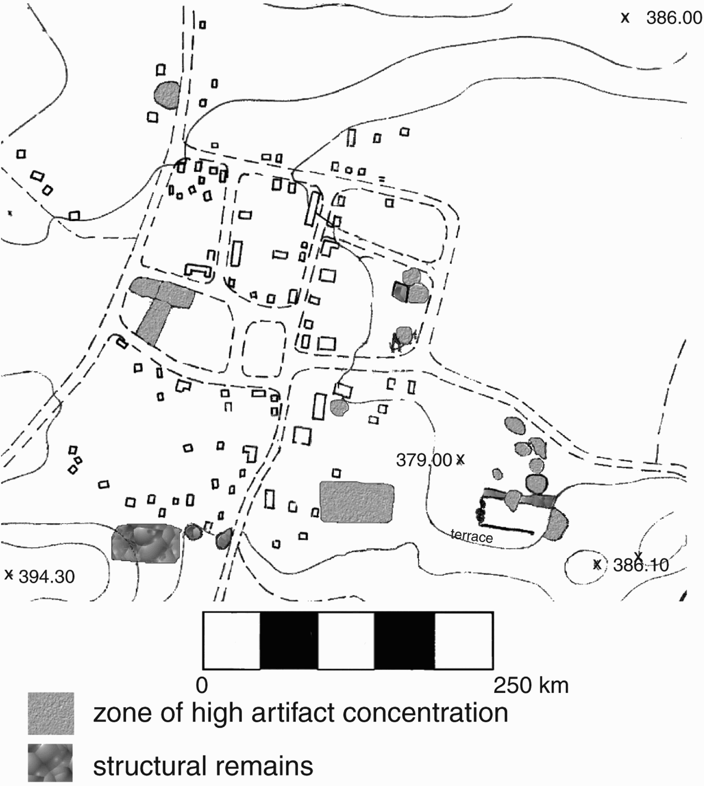
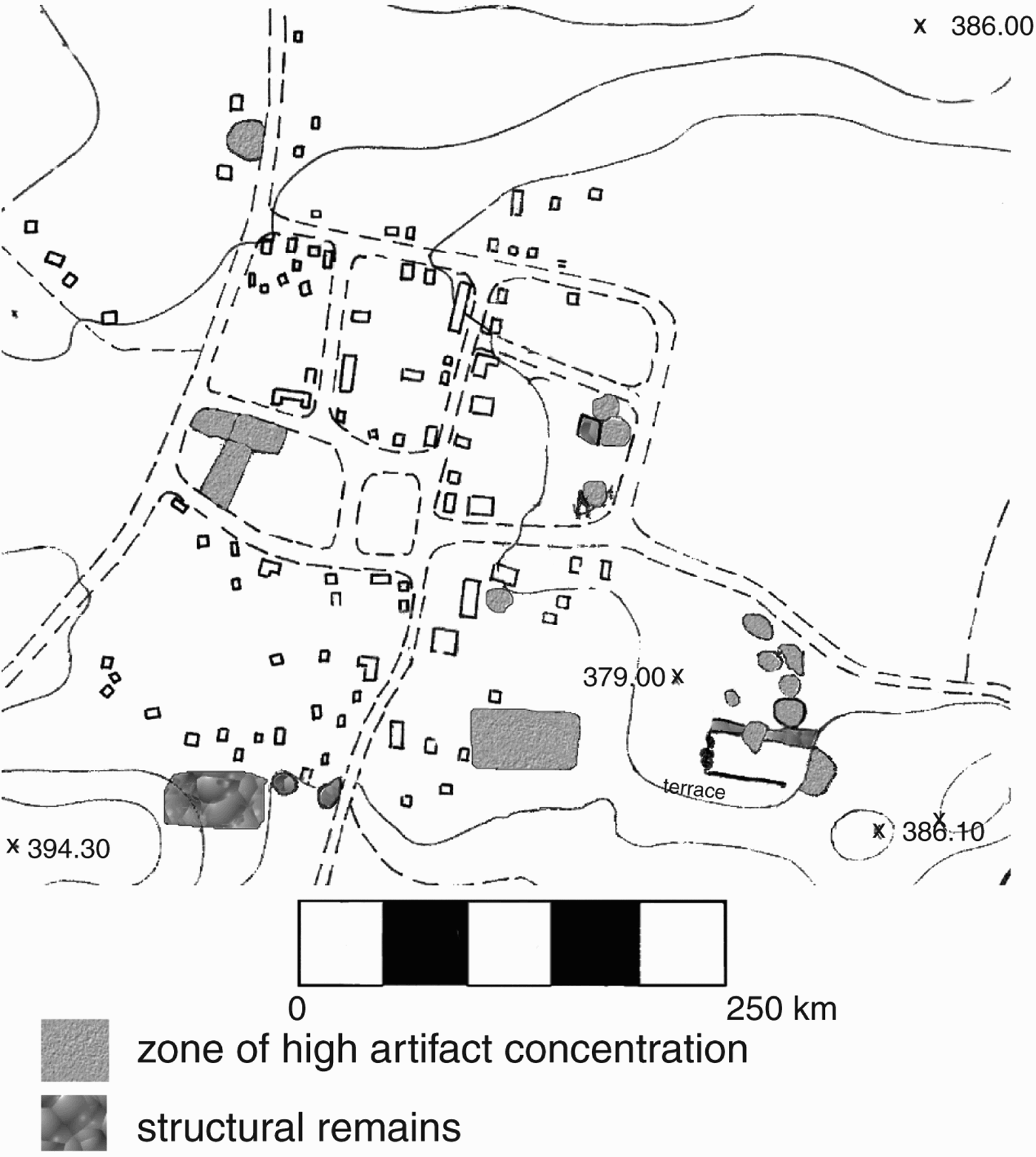
The incidence of nucleation in the Marroquín phase of a.d. 1580–1650 was not significantly different from nucleation frequencies in the Late Postclassic period Irraraga phase, but the manner of community integration was fundamentally different. By the Marroquín phase, the Izalcos landscape for the Spanish and indigenous alike was more disarticulated because boundaries strongly inhibited mobility and were statically defined to maintain control and possession. The fundamental disjunction in Spanish and Izalcos urban structure did not lie in the use of a grid system and the organization of space into solares (private household lots). The regular, grid-like pattern of Pancota structures and lots was reminiscent of Spanish urban arrangements, but the clustering of Pancota structures into symmetrical groups of two, four, and eight demonstrate a Nahua emphasis on paired units and equal relations to a whole. Although the Spanish reducción settlements of Caluco (Figure 14) and Nahulingo were organized around a central plaza with urban space extending in a regular pattern from this center, the urban plan was not balanced, and ordered pairs of structures were not emphasized. While earlier Nahua structures were built according to principles of symmetry and ordered groupings that arose out of social concerns for cellular independence, the Spanish principle for enclosure was generated by political and economic concerns related to centralized political control and individual accumulation. Under the Spanish system, the enclosure of the solar in town as well as larger enclosures defined private property in contrast to communal land and the household from the lands that supported it. What had been callalli became separate parcels of the household and farmland, separated by others' likewise fragmented spaces, a mosaic of private property. The city became the center of power and prime functions while rural areas became private domains.
Map of Caluco.
Spanish nucleated towns created by reducción further fractured the landscape because they created a divide between the urban and rural, a concept foreign to the Nahua that created a disjuncture between landscape meaning and form. Johnson (Reference Johnson1996:76) discussed landscape transformation in England and its relationship to the emergence of capitalism, noting that communal land had a one-to-one correspondence of ownership and control of land, so the form of the landscape and what it meant was clear. The largely post-medieval enclosure movement in England was a unifying, centralizing process, part of a “rational” process or symptom of “progress” (Johnson Reference Johnson1996:76, 83). Likewise, the policy of reducción was an effort by the Spanish to rationalize the landscape and its inhabitants. Thus, Nahua landscape use was more articulated than that of the Spanish in that each part related to an integrated whole while multiple barriers erected in the Colonial period defined possession and control.
The early colonial Izalcos economy relied heavily on indigenous knowledge of cacao production, and heavy tribute demands coupled with depopulation due to disease created a reliance on wage labor in the Izalcos region, which hardly abated as land increasingly converted to private property with the demise of the encomienda system. The increasing reach of private property necessarily created more landless population, generating an increased dependence on wage labor (Johnson Reference Johnson1996:75). As population rebounded in the late sixteenth to early seventeenth-century Marroquín phase, some of the dispersed patterning observed in the Late Postclassic reemerged. Both the needs of cacao cultivation and the locus of control entirely within the indigenous realm encouraged this return, but this indigenous landscape stood in sharp contrast to the rural/urban system of statically defined zones of private property within which it reemerged. Even though the considerable amount of communal land retained well into the eighteenth century may have preserved some of the integrated, dynamic features of the Nahua landscape, these lands were under constant threat and part of the discontinuous, static mosaic of the colonial system.
This fracturing and limitation of mobility affected all inhabitants of the region regardless of social role, class, ethnicity, or race. Among the Spanish in the Izalcos region, private ownership curtailed efforts at landscape knowledge even by officials of the Crown (Sampeck Reference Sampeck2007). During a visita de ojos (royal survey) in 1753 regarding the composición moderado (official securing of land rights; see Hill and Monaghan Reference Hill and Monaghan1987:64 for a detailed description) of the ejido (communal lands owned by the municipality) of Caluco, the survey party encountered a cattle ranch (estanzuela de ganado mayor) near the settlement of Las Canoas that was being rented by Don Valeriano de Artiaga from Don Ignacio Carrera, the owner of Hacienda San Diego Tonalá. All of the individuals associated with the hacienda tried their utmost to block the Caluco survey party from entering these lands, citing a previous survey and affirmation of title.
Don Valeriano argued that the survey party was well beyond the bounds of Caluco (Caluco Archive 1753: folio 84v).Footnote 2 The judge conducting the Caluco survey was unable to locate documents pertaining to the Hacienda Tonalá except for those documents presented by Don Francisco Medina Chacón, who measured the lands for Carrera, but the points defined in the survey of Medina Chacón were no longer observable (Caluco Archive 1753:folio 85, 88). Other documents showed that the residents of Caluco had bought the land at a cost of 1,300 tostones (Caluco Archive 1753:folio 85v). Multiple, conflicting documentation made the ownership of land uncertain.
The increased pressure by the royal survey party and Caluco residents to cede the lands was met by greater resistance from those of Tonalá. The next day the survey party was met by Don Manuel Antonio de Cárdenas, sent by Don Ignacio Carrera to stop the measurement of “his” land (“que venía con animo a que no prosiguiese las medidas por ser las tierras que ibán mensurado pertenecientes a su parte…” [Caluco Archive 1753:folio 87v]). The judge deemed that the measurement had to proceed and he ordered Cárdenas to leave the premises (Caluco Archive 1753:folio 88v). The residents of Las Canoas complained that they were not able to respond to Chacón's survey at the time it was conducted and had, in fact, requested that Don Juan Mencía, owner of Hacienda Tonalá, leave their lands (Caluco Archive 1753:folio 89). The hacienda owner in response ordered an annual payment of an arroba of wax for the “celebración del monumento” (Caluco Archive 1753:folio 90). The judge's resolution of this dissention was indicated when he referred to the estancia of Don Valeriano Artiaga as “en tierras usurpadas de esta hacienda de la cofradía…” (in lands usurped from the cofradía by this hacienda) (Caluco Archive 1753:folio 87).
This document of the Caluco archive lays bare a strategy for land appropriation by private parties: occupy the land, or even rent it out to others, so that multiple claims would be involved in any dispute; conduct one's own survey, perhaps with the tacit but illicit permission of key authorities; have one's own paperwork; and demand limited tribute/rent from the residents. While indigenous residents did not pay the tribute/rent, they did not force the usurper from the land, either. It was a strategy of intimidation on the ground and through paperwork, an active manipulation of landscape and text. The main recourse for indigenous residents was through the legal support of procuradores (lawyers assigned to help Indians), but the cost of lengthy litigation seems to have inhibited consistent and pervasive legal action to preserve indigenous rights. Individual ownership made the landscape discontinuous for Spaniards and indigenous inhabitants alike.
One way in which the disjuncture between the meaning and form of the landscape was negotiated was through maps because maps were keys to understanding the land and its ownership (Johnson Reference Johnson1996:92). This sentiment was clearly expressed in the Caluco archive materials in the residents' plea to have the visita de ojos complemented by a map, so that all would be able to see the legal disposition of the land. In contrast to the flexible Nahua system, Spaniards and Pipil alike became highly concerned with creating a static landscape defined by possession in order to gain or maintain control.
LANDSCAPE ORGANIZATION AND POLITICAL ECONOMY
Concurrent archaeological and ethnohistoric research in the Izalcos region has shown that in every phase mastery of the landscape created and maintained political, economic, and social power and was a statement about the ordering of the world (Bacon Reference Bacon1968:98–137; Braudel Reference Braudel1979:489–493; Deetz Reference Deetz, Kelso and Most1990:3; Isaac Reference Isaac1982; Leone Reference Leone, Miller and Tilley1984:26; Leone and Shakel Reference Leone, Shackel, Kelso and Most1990:164). Izalcos political economy was expressed in the highly integrated landscape made possible by Nahua organizational principles that emphasized cellular organization, symmetry, flexibility, and orderly flow. This archaeological analysis builds upon Lockhart's (1992) theoretical and idealized model for Nahua cultural organization by showing that the Izalcos Pipil especially emphasized dynamic flow. In every scale of analysis, Pipil organization was integrated by freely traversing the landscape, thereby uniting the related but discrete parts through movement. At the largest scale, the overall pattern of Pipil settlement in southern Mesoamerica was in scattered pockets or enclaves that formed a circuit along highly traveled routes. At the scale of the polity, the distance between different functional areas, such as from temple to domestic structure, had to be crossed to complete daily life in the loosely agglomerated settlement organization of the Río Ceniza Valley. This journey maintained and was demonstrative of the corporate solidarity of the calpolli. At an even smaller scale, the closest equivalent to the household was conceived of as a realm that was not limited to one locale. The dispersed, often discontiguous, nature of key elements in Nahua life ensured that no disjuncture between landscape form and meaning existed; the landscape was part and parcel of the altepetl, the calpolli, and the callalli. The very high degree of articulation in the Izalcos landscape contrasted with the adjacent Cuscatlan polity and perhaps was a distinctly Izalcos interpretation of Nahua principles.
Community integration in the Izalcos depended on freedom of movement, but that does not mean that the region was without boundaries. Late Postclassic period borders were archaeologically visible between the Cuscatlan and Izalcos polities as well as within the Izalcos region. These boundaries could be seen as a necessary consequence of cellular organization, distinguishing the independent elements that had to be knit together through movement. From this perspective, boundaries are not insurmountable barriers but instead provide definition for discrete yet essential parts of the system and make the dynamism of the landscape a necessity. Mobility on the landscape provided the countervailing force of union to the potential of the altepetl to fission, an ability rooted in the existence of boundaries.
This unusually high degree of integration and dependence on mobility in the Izalcos landscape was coupled with an equally unusual emphasis of cacao production. The ecology of the Río Ceniza Valley provided ideal conditions for intensive cultivation of cacao, and the loosely agglomerated settlement favored for tending cacao orchards coincided with Nahua organizational principles. Cacao cultivation also supported the Pipil focus on trade, literally providing currency to the exchange network. Mutually reinforcing features of ecology, technology, economy, and cultural organization reinforced the most unusual characteristics of the Izalcos Pipil, their hyper-production of cacao and hyper-articulated landscape.
The Spanish did not obliterate this indigenous system, but in many ways worked within its confines. The Spanish used inter- and intrapolity boundaries to establish jurisdictions, departments, municipios, and encomiendas, and the Spanish economy centered on intensive cacao production as part of an extensive trade network. The overall degree of settlement nucleation was only slightly greater in the colonial Marroquin phase, suggesting that the cellular Nahua pattern persisted. So, Pipil social, political, and economic systems superficially appeared to have withstood the conquest and indeed provided the foundation for the colonial political economy.
Delving deeper into inter- and intrasite structure showed that the superficial similarity to pre-Conquest social, political, and economic forms was generated by very different processes and that the fundamental principle of mobility on the landscape no longer applied. In the transition to capitalism, land had to be partitioned into segments that were not supposed to unite but instead be separate and private. Movement was thwarted because it challenged ownership. Even the Crown's own officials were thwarted from entering these private domains. Because Pipil production was the basis of the economy, communal lands maintained indigenous systems of landscape use, but this was nested within larger zones of possession and control that subverted indigenous organization. The pre-Conquest integration of the landscape was fractured into the dichotomy of rural and urban, with cities no longer fully integrated into the altepetl nor emphasizing symmetrical relations. Both the internal organization and the conscious integration of these settlements into hierarchies at increasingly expansive levels skewed the cellular Nahua system. Spanish goals of centralized, asymmetrical political power were replicated in the microcosms of social, political, and economic order of their nucleated settlements and rural hinterland, creating a static, disarticulated landscape.
The tensions between these two organizational systems seems to have escalated over time so that by the late seventeenth century the mature hacienda mode of organization stood in contrast to pockets of communal land. Tensions likewise escalated in urban centers so that some, such as Izalco, became bifurcated into Indian versus ladino barrios. These contrasts represent the assertion of indigenous power and a persistent threat to colonial and later republican authority. These tensions laid the foundation for the atrocities of 1932 (la matanza), in which thousands of Indians were slaughtered in response to an uprising in the Izalcos region.
These changes appear to present an evolutionary model of transition from a corporate social system to feudal or semi-feudal organization, but such terminology minimizes the complexities of each period and the process of change. Corporate features of Pipil society existed under constant tension to fission, and these dispersive processes appeared to be prominent at the time of Spanish arrival (Sampeck Reference Sampeck2007). Indeed, transition to private ownership of cacao orchards appears to have been underway before contact (Fowler Reference Fowler and McNeil2006). Two adjacent Pipil polities, the Izalcos and Cuscatlan, show that the altepetl was not of a single, invariant form but that the characteristics of the political economy depended upon local conditions and historical development. Feudal models tend to be static and often minimize agency of less powerful groups. Spanish merchants and encomenderos profit from the cacao trade was couched within Pipil terms of production. The material culture of Spanish and Pipil households is archaeologically almost impossible to distinguish (Verhagen Reference Verhagen1997) and suggests a common ability to purchase and consume (Sampeck Reference Sampeck2007). In other words, the Izalcos Pipil were full participants in rather than merely victims of the colonial market economy. Describing the early colonial Izalcos political economy as “feudal” also masks important developments relating to the rise of capitalism that were already operative, such as an entrenched system of wage labor. Such elements of the rise of capitalism, however, were better understood by using a model for analysis that considered changes in the degree of mobility and articulation in the Izalcos landscape. The profound subversion of Pipil social life by Spanish conquest was through limiting mobility and dismantling the high degree of articulation of the Late Postclassic landscape. The challenge for future work includes determining how this colonial disarticulation matures in the eighteenth and nineteenth century; investigation of similar patterns of changes in mobility on the landscape with conquest can be observed in regions such as coastal Guatemala that seem to have had a strong affinity to the Izalcos; as well as continuing to tease out other details of the nature of services and estate requirements and their archaeological expression before and after Spanish contact. Izalcos landscapes are both a point of departure and a final destination in understanding how changes in this corner of the Nahua world related to the colonial enterprise.
RESUMEN
Datos etnohistóricos han demostrado que los Izalcos de el oeste de El Salvador fueron pipiles de habla Nahua y que formaron uno de los Estados prehispánicos regionales más poderosos en el sureste de mesoamérica. Los Izalcos tenían una extraordinaria producción de cacao y por ello la región llegó a ser famosa en la época colonial. Documentos del archivo de Caluco de los siglos XVI hasta XIX y otros datos históricos indican que los pipiles de los Izalcos tenían una estructura social y política semejante a la de los Nahuas. Las sistemas de organización social y política típico de los Nahuas son demostrados en la ubicación de asentamiento y de la organización de sitios en la zona de los Izalcos y también en la distribución del asentamiento Nahua in el sur de mesoamérica. Los españoles no borraron los conceptos, instituciones, y fronteras políticas de los Izalcos ya que ellos formaron el cimiento de la economía política colonial. Los cambios notables entre la economía política antes y después la conquista son observables en la organización cultural del paisaje. Aunque la frecuencia de nucleación no cambiaron dramáticamente antes y después la conquista, las causas de patrones similares eran distintos. Durante el período posclásico tardío los asentamientos fueron abundantes pero no nucleados y estructuras importantes tal como templos fueron aislados. Este patrón de asentamiento sugiere que los residentes tenían aceso libre que resultó en un ambiente cultural dinámico y integrado que favorezó movimiento libre y una economía política que fomentó independencia y intercambio. Después de la conquista el patrón de asentamiento tenía más sitios nucleados y impedimentos a movimiento debido al nacimiento de la propiedad privada, el capitalismo, y un gobierno centralizado.
Acknowledgments
A Tinker grant through the Roger Thayer Stone Center for Latin American Studies at Tulane University funded the feasibility study for this research. Years of archaeological research were made possible by several grants from the Middle American Research Institute, as well as dissertation research grants from Fulbright-Hays, the Wenner-Gren Foundation for Anthropological Research, the Social Science Research Council, and the National Science Foundation (dissertation improvement grant #9521749). A grant from the Mesoamerican Ethnohistory Fund of Tulane University made the transcription of the Caluco archive possible.
This manuscript benefited greatly from the insightful comments of E. Wyllys Andrews, Jeb Card, and William R. Fowler. I wish to thank John Chance, Matthew Johnson, Charles Orser, and an anonymous reviewer for their thoughtful critiques. Any errors or omissions are my own.