INTRODUCTION
Despite huge advances in marine science in the past few decades and increasing public awareness of marine conservation, marine biological diversity is still vastly underestimated (Norse Reference Norse1993). The processes that control the distribution of biological diversity in the marine environment are complicated and current research is incomplete (Jackson Reference Jackson1991, Reference Jackson1994; Norse Reference Norse1993; National Research Council 1995). This lack of knowledge causes problems when areas come to be prioritized for conservation or human impacts resulting in environmental changes, loss of habitats or loss of species need to be mitigated (Gladstone & Davis Reference Gladstone and Davis2003; Terlizzi et al. Reference Terlizzi, Bevilacqua, Franschetti and Boero2003; Guzman et al. Reference Guzman, Guevara and Breedy2004).
The rapid losses of coral reef habitat and associated reductions in species diversity that have occurred over decades owing to pollution, overfishing and global warming have major implications for fisheries, tourism and global biodiversity. Researchers, governments and funding agencies have made efforts to understand how these losses have affected abundances and distributions of particular species and the structure and functioning of the ecosystem. Fundamental to this greater understanding are the examination and monitoring of the current distribution, composition and condition of the reefs, evaluation of species diversity at various taxonomic levels and investigation across large spatial scales. Sensitive and important conservation areas should not be left unprotected and existing protected areas should ultimately include the broadest range of species and habitat variations possible.
Coral reef conservation in Pacific Panama has been gaining momentum since the establishment of the Coiba National Park in 1991. Much is known about distributions, biological processes and previous deterioration of coral reefs in the region, but little information exists to guide future coral reef conservation priorities (Glynn & Maté Reference Glynn, Maté, Lessios and MacIntyre1996; Maté Reference Maté and Cortés2003). These reviews cover only a few localized coral reefs and focus predominantly on the scleractinian corals, leaving the present range of species (for example gorgonian corals) and habitats/assemblages undersampled at small scales and often extrapolated to landscape scales (Murdoch & Aronson Reference Murdoch and Aronson1999). Such studies do not provide the information required for management and selection of priority conservation areas at the local or regional scales (Gladstone & Davis Reference Gladstone and Davis2003). Guzman et al. (Reference Guzman, Guevara and Breedy2004) partially remedied this situation when they reported on the distribution and species richness of coral habitats in the World Heritage's Coiba National Park in the Gulf of Chiriquí and used this information to recommend priority areas for conservation around the island. However, in the neighbouring Gulf of Panama, there has been no recent extensive survey. Las Perlas is one of only two archipelagos (after Galapagos) and considered a key ecological area along the Tropical Eastern Pacific (TEP) (Lessios & Robertson Reference Lessios and Robertson2006). Coral reefs and coral communities within Las Perlas Archipelago have developed under two different seasonal hydrological regimes (D'Croz & O'Dea Reference D'Croz and O'Dea2007) and enclose vulnerable habitats with a high regional diversity and endemism of reef fishes (Allen & Robertson Reference Allen and Robertson1994; Benfield et al. Reference Benfield, Baxter, Guzman and Mair2008).
Here we describe the reefs and coral communities of Las Perlas Archipelago in the newly created 1688-km2 Marine Special Management Zone (MSMZ, created under Panamanian Law 18 of May 2007) located in the Gulf of Panama. This aim of this study was to provide a landscape inventory of alpha-diversity, assess live coral cover status in coral habitats, and recommend priority areas for conservation and zones to aid in the development of the management plan (currently being drafted), and the regional integration of the MSMZ into the Marine Conservation Corridor of the Tropical Eastern Pacific (MCCTEP) or defined marine ecoregions (see Krupnick & Kress Reference Krupnick and Kress2003; Spalding et al. Reference Spalding, Fox, Allen and Davidson2007). Particularly, we aimed to: (1) characterize the alpha species richness distributions of scleractinian and gorgonian corals; (2) describe the distribution of cover of live coral and other sessile organisms; and (3) define priority conservation areas within the archipelago.
MATERIALS AND METHODS
Study area
Las Perlas Archipelago lies between 08°40′19′N, 79°03′49′W (Isla Pacheca) and 08°11′46′N, 78°46′31′W (Isla Galera), approximately 70 km off the Pacific coast of Panama City (Panama) within the Gulf of Panama. It is composed of 250 basaltic rock islands and islets, the majority of which are uninhabited. The new marine protected area, defined locally under the category of Special Management Zone by Law 18, encompasses all of the islands and Bajo Trollope, a rocky outcrop at the south-east corner of the archipelago. The MSMZ was created to implement an integrated coastal management approach including the production side of fisheries and tourism and long-term landscape conservation planning (sensu Margules & Pressey Reference Margules and Pressey2000). Besides protecting coral reefs, Law 18 incorporates reef fishes and mangrove forests, prohibits the use of gill-net, sieve-net and long-line fishing in the whole archipelago and only allows artisanal line fishing to reduce overfishing. Fishing of sharks and rays is explicitly prohibited. A five-month ban on lobster fishing is implemented every year from December to April, and poaching of turtle eggs and meat is also prohibited. Law 18 creates the governance framework for the marine realm with strong participation of local authorities and fisherfolk.
Land use is unregulated under Law 18, however the relatively pristine state of the islands is a conservation priority. The islands are covered predominantly by tropical rainforest and contain many rivers, of which those on the two largest islands (San Jose and Del Rey) are protected. Over 98.2 km2 of forest and the largest watersheds on Isla Del Rey were designated a Hydrological Reserve in October 2006, while the entire island of San Jose is protected as a Private Nature Reserve. The islands are partially and seasonally affected by river input from the mainland.
Las Perlas Archipelago is located within the 50 m isobath, and falls within the TEP biogeographic zone, which stretches from the Sea of Cortez, off California, to the northern Pacific coast of Peru (Allen & Robertson Reference Allen and Robertson1994; Cortés Reference Cortés1997). The region's climate is humid-tropical monsoonal. It experiences two seasons controlled by the migration of the Intertropical Convergence Zone (ITCZ) over Panama: the dry season (mid Dec–mid Apr) and a wet season for the remainder of the year. Associated with the dry season is a strong period of upwelling in the Gulf of Panama that results in high marine productivity that reduces light penetration through the water column, while horizontal visibility can be reduced to 1–2 m (compared to the normal 6 m) (Glynn & Maté Reference Glynn, Maté, Lessios and MacIntyre1996; D'Croz & O'Dea Reference D'Croz and O'Dea2007). Salinity in the Gulf of Panama is considered the lowest in the entire eastern Pacific (Pennington et al. Reference Pennington, Mahoney, Kuwahara, Kolber, Calienes and Chavez2006). The mean tidal range for the archipelago is 3.7–3.8 m (Glynn & Maté Reference Glynn, Maté, Lessios and MacIntyre1996).
The coral reefs of this region (Glynn & Stewart 1973; Glynn Reference Glynn1977; Guzman et al. Reference Guzman, Guevara and Breedy2004) occur in shallow water (<15 m) and are characterized by their small size (a few hectares), discontinuous distribution and low species diversity (Cortés Reference Cortés1997) and complex food webs (Glynn Reference Glynn2004). The largest aggregation of coral reefs in the Gulf of Panama lies in Las Perlas Archipelago (Glynn & Maté Reference Glynn, Maté, Lessios and MacIntyre1996). The main reef building corals are Pocillopora damicornis and Pocillopora elegans, but slower-growing massive corals such as Pavona lobata and Pavona clavus (Glynn & Stewart Reference Glynn and Stewart1973; Glynn Reference Glynn1977) occur in deeper areas or in isolated patches with few exceptions (Guzman et al. Reference Guzman, Guevara and Breedy2004). The other dominant sublittoral coral habitat is bedrock supporting scleractinian corals and octocorals but not forming carbonate reef frameworks, hereafter referred to as coral communities. The total areas of coral reefs and coral communities in Las Perlas are c. 110 ha and 197 ha, respectively (Benfield Reference Benfield2005). Macroalgae dominated areas are present but are uncommon and seagrass beds do not occur within the archipelago.
The coral reefs of Las Perlas Archipelago are affected by warming associated with El Niño Southern Oscillation events, and threatened by sedimentation, pollution, overfishing, coastal development and tourism if Law 18 is unsuccessful. Most of the changes to the coral reefs in recent times occurred during the 1980s and were associated with the 1982/1983 El Niño event (Glynn et al. Reference Glynn, Cortes, Guzman, Richmond and Choat1988). In contrast, the 1997/1998 El Niño event had little effect on the reefs of the archipelago (Glynn et al. Reference Glynn, Mate, Baker and Calderón2001).
Distribution of species richness in coral reefs and coral communities
Although the use of species-area curves for checking optimum species richness is recognized as a standard procedure (Beger et al. Reference Beger, Jones and Munday2003; Gladstone & Davis Reference Gladstone and Davis2003), we aimed to survey the entire coastline of every island and islet (sensu Guzman et al. Reference Guzman, Guevara and Breedy2004) because of the patchy distribution of coral and octocoral populations in the eastern Pacific (Glynn & Wellington Reference Glynn and Wellington1983; Guzman & Cortés Reference Guzman and Cortés1993; Cortés Reference Cortés1997) and the geomorphologic complexity of the archipelago. Accordingly, we arbitrarily divided every 2 km of the shallow coastal zone (<15 m deep) into 108 polygon areas (defined and georeferenced a priori) to facilitate survey and thematic mapping using a geographic information system. The coast of the archipelago was assessed by manta survey (Millar & Müller Reference Millar and Müller1999; Guzman et al. Reference Guzman, Guevara and Breedy2004) during four expeditions to the islands during August 2003 and May 2004. We characterized the scleractinian and octocoral assemblages, located rare species, identified areas of high species richness, assessed the distribution of coral reefs and coral communities and obtained a qualitative estimate of coral cover. In addition, we further assessed species richness at depths of ≤25 m at 53 randomly chosen sites throughout the archipelago through scuba diving surveys (see live coral cover method). Whenever necessary, we collected organisms for subsequent classification. We compiled a comprehensive presence/absence list of species for scleractinian corals and octocorals using manta and diving surveys. We developed a distribution map for species richness (number of species) for coral communities or dominant habitats, in which we assigned each of the 108 polygons to one of the three categories ‘high’ (>38), ‘moderate’ (19–38) or ‘low’ (<19).
Live coral cover and distribution
We quantified live coral cover and species composition at 53 sites, including reefs and coral communities using three 10-m long replicate transects placed parallel to the coast and at two depths (Guzman & Guevara Reference Guzman and Guevara1999; Guzman et al. Reference Guzman, Guevara and Breedy2004). We visually estimated coverage of corals, macroalgae, crustose coralline algae and sponges along each transect using a 1-m2 quadrat divided into 100 cells of 100 cm2 each. As vertical development of Eastern Pacific coral reefs and communities is limited, it was not always possible to sample both depths at all sites, however we always surveyed the same total area per site (60 m2). Because coral communities are widely distributed along the coastline of the archipelago and usually have a higher diversity of corals than reefs, we developed a thematic map of live coral cover in each polygon only for these habitats based on the manta survey data. We grouped live coral cover into three categories, namely high (>40%), moderate (20–40%) or low (<20%). We based the visual definition of these percentage categories at each of the 108 polygons on previous analysis and description of the coral cover at the 53 sites (Guzman et al. Reference Guzman, Guevara and Breedy2004).
Data analysis
We used PRIMER V5.0 software (Clarke & Warwick Reference Clarke and Warwick2001) to perform multivariate analysis of the marine communities. Species composition of corals and octocorals (presence/absence data) was compared in the 108 polygons surveyed using the Bray-Curtis similarity coefficient on non-transformed data. We sorted this information using cluster analysis with group averaged sorting and non-metric multidimensional scaling (MDS), performing each MDS analysis 50 times. We used ANOSIM to test statistical differences in species composition (presence/absence) among coral cover categories based on the similarity matrix produced from PRIMER. We also compared the difference in species richness (scleractinian and octocorals) between coral cover categories using Kruskal-Wallis and Dunn's test, as the data could not be adequately transformed to pass a normality test.
We repeated the clustering and MDS processes in PRIMER using the percentage cover data for coral species and other benthic cover (for example algae) from the 53 sites assessed using transects. We used ANOSIM to determine if there were any differences in the species composition of coral reefs and coral communities. We also conducted a Spearman rank correlation analysis using the data from the 53 sites assessed using transects to determine if there was any correlation between species richness and coral cover; we used this non-parametric test because the species richness data could not be adequately transformed for normality. We also compared coral cover, algal cover and species richness between the coral reefs and coral communities using a t-test (and Mann-Whitney test when we could not successfully transform data).
RESULTS
Species richness in coral reef and coral communities
During the survey of the archipelago, we observed 57 coral species in total, 19 scleractinian corals in six genera and 38 octocorals in seven genera (Appendix 1, see Supplementary material at URL http://www.ncl.ac.uk/icef/EC_Supplement.htm). The coral composition of coral reefs, built up and dominated by Pocillopora damicornis (sensu Glynn et al. 1972), was typical of Pacific Panama. We found massive Porites species in the slightly deeper areas away from the Pocillopora dominated bands. The composition of coral communities was generally more varied, with more octocoral species (Appendix 2, see Supplementary material at URL http://www.ncl.ac.uk/icef/EC_Supplement.htm).
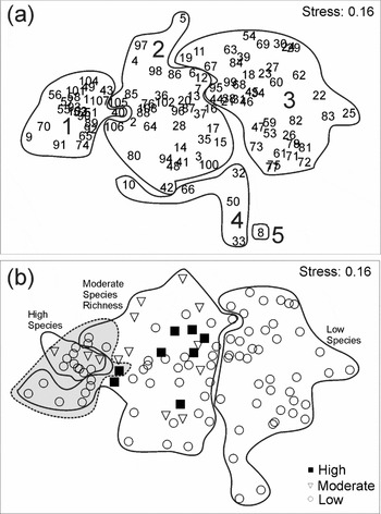
Cluster analysis indicated five species assemblages (Appendix 3, see Supplementary material at URL http://www.ncl.ac.uk/icef/EC_Supplement.htm), one of which had only one polygon in it (polygon 8). MDS indicated that groups 1, 3 and 4 differed from each other, but group 2 overlapped with 1, 4 and 5 (Fig. 1a). Groups 1 and 3 had the highest and lowest species richness, respectively. Group 1 incorporated all the polygons with highest species richness, with over 60% of the 57 species occurring in 22% of the polygons (Fig. 1b, dotted line). The number of species found did not differ between coral reefs and coral communities based on the site data (Mann Whitney U = 488.5, p = 0.186).
(a ) MDS of polygon data based on presence/absence of coral and octocoral species in the five groups; (b ) MDS on categories of coral cover in coral communities (high >40%, moderate 20–40% and low <20%) grouped into three species richness categories (from left to right: high, moderate, low). Group 1 (in (a)), the sites with greatest species richness, is identified by a dotted line in (b).

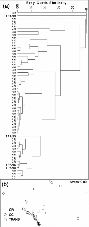
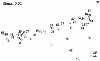
Coral and octocoral species composition varied between coral reefs and coral communities across the 53 sites (Fig. 2). ANOSIM corroborated this difference (R = 0.376, p < 0.001). MDS plot of live coral, algae, crustose coralline algae, octocoral and sponge cover showed coral reef and coral community site groupings (Fig. 3), and ANOSIM showed the two habitats differed in benthic composition (global R = 0.371, p < 0.001).
(a ) Cluster analysis of live coral and octocoral % cover data in the 53 sites by reef type; (b ) MDS of site live coral and octocoral cover data (CR = coral reef, CC = coral community, TRANS = transition from community to reefs).

MDS of sites based on benthic composition (% live cover of corals, algae, crustose coralline algae, octocorals and sponges) showing clustering of coral reef (CR) and coral community (CC) sites.

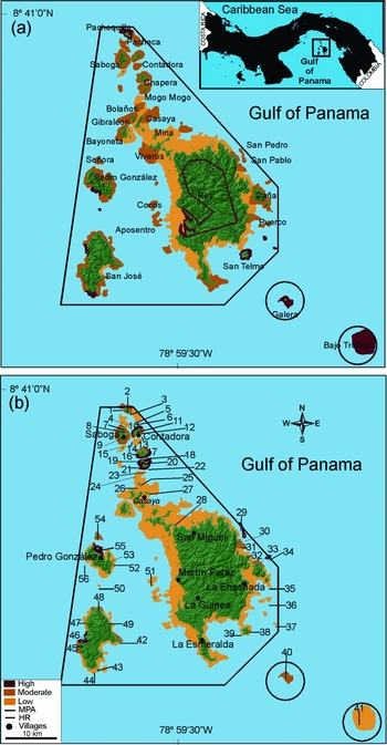
Classifying the 108 polygons into species richness categories indicated several areas with high species richness (Fig. 4a): Isla Galera, Isla San Telmo, Isla Camote, Isla Monte, and Bajo Trollope in the southern part of the archipelago, the south and west coast of Isla San Jose, the south-west shore of Isla Pedro Gonzalez and the northernmost islands, especially Isla Pacheca and Pachequilla. Isla Del Rey had the lowest species richness in the archipelago, although there were a few moderately species rich areas off the southern tip and on the east coast. A large area of low species richness occurred around Isla Viveros and Isla Mina.
(a ) Distribution of coral and octocoral species richness in coral reefs and coral communities of the Las Perlas Archipelago marine protected area (black polygon), based on the species richness categories: high (>38), moderate (19–38) and low (<19). Watersheds, rivers and the El Rey Hydrological Reserve (red polygon) are shown. (b ) Distribution of live coral cover in coral communities in Las Perlas Archipelago, in categories: high (>40%), moderate (20–40%) and low (<20%). Numbers indicate sites (Appendix 2, see Supplementary material at URL http://www.ncl.ac.uk/icef/EC_Supplement.htm).

Live coral cover and distribution
Across the coral reef sites (n = 32) mean live coral cover was 61.2% (range 0.1–96.4%) (Appendix 2, see Supplementary material at URL http://www.ncl.ac.uk/icef/EC_Supplement.htm). Mean algal (frondose and turf) and calcareous algal cover was 32.5% and 5.0%, respectively. Mean live coral cover in coral communities (26%, n = 20) was less than that of coral reefs (t-test, t = 4.95, df = 47, p < 0.001) (Appendix 2, see Supplementary material at URL http://www.ncl.ac.uk/icef/EC_Supplement.htm), whereas mean algal cover was higher (65.7%; t-test, t = −4.989, df = 47, p < 0.001). Calcareous algal cover was also higher on coral communities (mean 7.6%).
Species richness differed between the coral cover groupings from the polygon data (Kruskal-Wallis test, H = 12.156, df = 2, p = 0.002). At the polygon level, spatial distribution of low to moderate coral cover generally coincided with high species richness (Fig. 4), and MDS indicated a negative relationship between coral cover and species richness (Fig. 1b). However, ANOSIM indicated that the presence/absence data did not differ among the three coral cover categories (global R = −0.019, p = 0.63), and Spearman rank correlation indicated no association between live coral cover and species richness at site level.
The coral reef sites with the highest live coral cover occurred at the north and east shores of Isla Contadora (80%) and Isla Mogo Mogo (> 74%) (Appendix 2, see Supplementary material at URL http://www.ncl.ac.uk/icef/EC_Supplement.htm). In the southern part of the Las Perlas Archipelago, the northern shore of Pedro Gonzalez had the highest coral cover (96.4%), and high coral cover also occurred at Isla San Pedro (93.7%). We found the highest coral community coral cover at the southeastern corner of Contadora (76.8%) and in the San Telmo islands (50.4%) (Appendix 2, see Supplementary material at URL http://www.ncl.ac.uk/icef/EC_Supplement.htm). The highest octocoral cover occurred in a coral community at Puerco Islet (Appendix 2, see Supplementary material at URL http://www.ncl.ac.uk/icef/EC_Supplement.htm).
At polygon level, the central area of the archipelago, including Del Rey, Viveros, Mina, Casaya and Bayoneta islands, had low coral cover (Fig. 4b). Coral cover was highest in the northern area of the archipelago around Isla Contadora, Mogo Mogo, Saboga and Chapera. Other high coral cover areas were found at a few islands on the east coast of Del Rey, Pedro Gonzalez and San Jose islands.
DISCUSSION
Areas of high coral cover and species richness were not evenly distributed throughout the Las Perlas Archipelago. We distinguished five groups, with groups 1 and 3 having the highest and lowest numbers of species, respectively, indicating that the species composition differed around the island coasts. Less than a quarter of the 108 polygons had high species richness, and this has important implications for the zoning phase proposed for the MSMZ and for selecting marine reserves servicing the entire archipelago and the TEP biological corridor.
The central region of the archipelago (most of the coastline of Del Rey, Viveros, Mina and Casaya islands) proves to be less important in terms of live coral cover and coral species richness, while the northern islands from Isla Mogo Mogo north are relatively more important in this regard. River discharges may explain the distribution of cover and diversity in reefs around the largest island (Fig. 4a), although sedimentation is not perceived to be serious. However, to ensure the long-term maintenance of biodiversity within a network of marine conservation areas, we have to consider the potential conflict between biodiversity conservation interests and human land-use issues. The protection of most of the watersheds in the Del Rey Hydrological Reserve and the creation of the San Jose Natural Private Reserve are considered important in controlling future sedimentation in the coastal zone.
In the Las Perlas Archipelago, we did not find the positive relationship between coral cover and species richness found around Isla Coiba in the neighbouring Gulf of Chiriquí (Guzman et al. Reference Guzman, Guevara and Breedy2004). In fact, we found the reverse for coral communities, suggesting there is no standard conservation ‘formula’ for the maintenance of biological diversity associated with reefs in the region, but that a surveying landscape approach may help to define priority areas or, in some cases, a species-specific approach could be taken (Beger et al. Reference Beger, Jones and Munday2003). It is expected that the bigger the area the more variable will be the mosaic of habitats, and the greater the species diversity. Some areas (such as Isla Galera, Isla San Telmo, Isla Camote, Isla Monte, Bajo Trollope, the south and west coast of Isla San Jose, the south-west shore of Pedro Gonzalez, Pacheca and Pachequilla islands) had high species richness but in most cases low coral cover (Fig. 4). Where live coral cover was highest (for example on the north and east shores of Isla Contadora, southern Isla Chapera, Isla Mogo Mogo, north shore of Isla Pedro Gonzalez, west San Jose, San Pedro and San Pablo islands), coral species richness tended to be lower. These were coral reef sites; thus the typical coral reef structure of this region, which forms almost monospecific swaths of reef (mainly built up Pocillopora damicornis), does not appear to be conducive to diverse species assemblages. This has important ramifications for planning priority areas for protection in the archipelago and elsewhere across the TEP because the areas with most live coral cover (i.e. the coral reefs) alter from those with high species diversity (generally coral communities for the TEP). Pocillopora damicornis reefs in Las Perlas and the rest of the TEP do not provide suitable environment for the growth of different species because ‘structural species’ do not create an adequate substrate and resource that can then be used by other species (‘interstitial species’), and therefore may not contribute to maintenance of coral diversity (sensu Reyers et al. Reference Reyers, Fairbanks, Wessels and Van Jaarsveld2002). Subtidal rocky habitats dominate at the landscape level and are important for marine reserve selection.
The coral communities of the archipelago differed in species composition and had higher species richness than typical Pacific Panama coral reefs (Guzman et al. Reference Guzman, Guevara and Breedy2004). Coral communities also differed in benthic composition, with a higher cover of octocorals, which occur less frequently on coral reefs. The MSMZ management plan should therefore include a significant proportion of coral communities (for example Bajo Trollope, the whole of San Jose Island, southern coast of Pedro Gonzalez Island, and San Telmo, Galera, Mogo-Mogo and Pachequilla islands) in fully protected marine reserves. Clearly conserving the maximal species richness within a minimum area does not necessarily ensure the maintenance of biodiversity as a whole and the inclusion of species assemblages with associated environmental gradients should ensure conservation of biodiversity patterns and processes at a larger scale (sensu Reyers et al. Reference Reyers, Fairbanks, Wessels and Van Jaarsveld2002).
We found several species previously thought to be rare during our survey, including Gardinoseris planulata (Glynn & Ault Reference Glynn and Ault2000; but see Guzman et al. Reference Guzman, Guevara and Breedy2004), Pocillopora eydouxi, Pocillopora inflata (Mate 2003; but see Guzman et al. Reference Guzman, Guevara and Breedy2004) and Pavona cf. duerdeni (Guzman et al. Reference Guzman, Guevara and Breedy2004). We also identified areas with recently described new octocoral species, such as Pacifigorgia smithsoniana (Breedy & Guzman Reference Breedy and Guzman2004). Excluding ahermatypic coral species, we found 56 coral species, 17 less than in the Gulf of Chiriquí (Panama's hot spot; Guzman & Breedy Reference Guzman and Breedy2007) and 14 more than Caño Island (Costa Rica's hot spot; H.M. Guzman unpublished data 2008). Review of regional coral diversity representativeness is desirable with a view to better designing small-scale reserves across the TEP (Kati et al. Reference Kati, Devillers, Dufrene, Legakis, Vokou and Lebrun2004) and beyond sites currently considered priority along the biological corridor. In order to design this TEP reef network, recent biogeographical analysis (Glynn et al. Reference Glynn, Wellington, Riegl, Olson, Borneman and Wieters2007), understanding of short-distance larval dispersal and self-recruitment (Levin Reference Levin2006) must be considered, and comparable survey methodologies used to identify potential areas.
Conserving Panamanian and offshore Costa Rican reefs (Guzman & Cortes Reference Guzman and Cortes2007) is essential to restoring natural processes elsewhere along the biological corridor. Connectivity across the TEP biological corridor and its marine ecoregions is possible (Wellington & Victor Reference Wellington and Victor1992; Lessios & Robertson Reference Lessios and Robertson2006), however even if population sources are identified, regional recruitment may depend on anomalous or occasional hydrographic events (Salomon et al. Reference Salomon, Ruesink and DeWreede2006). For instance, based on observed recovery Panamanian Pacific reefs have the potential for self-recruitment (Guzman et al. Reference Guzman, Guevara and Breedy2004; this study). Reefs may serve as a coral and fish larvae source restoring downstream northern reef areas bathed year-round by the prevailing Costa Rican coastal current as far as the Gulf of Tehuantepec (Guzman & Cortes 1993; Kessler Reference Kessler2006), or southward during the interannual flow of the ‘Panama Current’ that reaches as far as the Galapagos Islands (Glynn et al. Reference Glynn, Gassman, Eakin, Cortés, Smith and Guzman1991; Glynn & Mate 1996; Glynn Reference Glynn and Cortes2003; Kessler Reference Kessler2006; but see Cowen et al. Reference Cowen, Lwiza, Sponagule, Paris and Olson2002; Levin Reference Levin2006).
We designed this comprehensive survey to evaluate and describe the types, species composition and distribution of coral habitats of the Las Perlas Archipelago. The number of islands and islets and the complexity of the coastline required increased effort and the large sampling scale adopted in this study. The survey methods increased the chance of finding the majority of coral and octocoral species, provided a more comprehensive assessment of the archipelago's coral reefs and coral communities and their diversity than previous studies (reviews in Glynn & Mate 1996; Mate 2003) and should be extended to other areas across the TEP. This study is vital to the process of designating this area as a MSMZ and, as it provides information about the locations of areas with high coral species richness and cover, may prove useful in determining future no-take marine reserves zoning.
Finally, we consider the main anthropogenic threats to the coral reefs and communities of the islands are overfishing, sedimentation and tourism. Several fish species (such as snapper, grouper and anchovy) were fished in the waters of the archipelago, as were shellfish species (such as spiny lobsters and prawns). We expect that the new fishing regulations implemented within the MSMZ will reduce or control this impact on the ongoing recovery of reefs. Thus, the proposed no-take areas may enhance altered trophic cascades in other areas within the MSMZ and outside its border where existing regulations permit artisanal fishing (sensu Lubchenco et al. Reference Lubchenco, Palumbi, Gaines and Andelman2003; Mumby et al. Reference Mumby, Dahlgren, Harborne, Kappel, Micheli, Brumbaugh, Holmes, Mendes, Broad, Sanchirico, Buch, Box, Stoffle and Gill2006). Sedimentation and run-off from land can cause localized smothering of corals, hence tourism and associated coastal development arguably poses the greatest current threat to the coral reefs and communities of the archipelago. If not effectively managed, such development could result in increased sedimentation during the construction phase, chronically polluting the coral habitats.
ACKNOWLEDGEMENTS
We thank C. A. Guevara and the crew of the R/V Urracá and A. Lam for logistical field support, and J. M. Guevara for the maps. The project was partially funded by the DEFRA Darwin Initiative Fund, Heriot-Watt University (UK), and the Smithsonian Tropical Research Institute. We thank the Government of Panama for providing the permits to collect and work in the country and in marine protected areas.