

INTRODUCTION
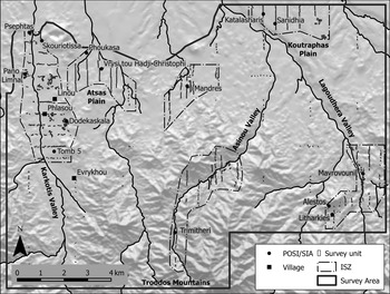
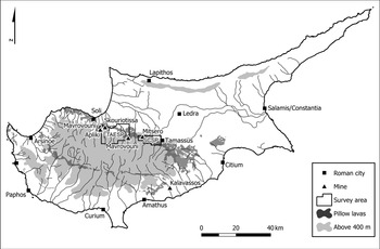
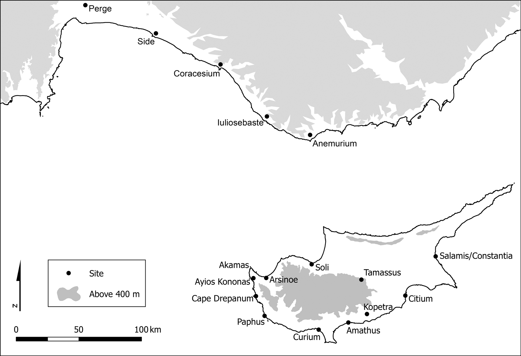
Between 2000 and 2005 the Troodos Archaeological and Environmental Survey Project (TAESP) studied the hinterland of Skouriotissa, the largest of the great copper mines in the northern Troodos, Cyprus.Footnote 1 Apart from Skouriotissa, the dominating landscape elements in the TAESP area are the Troodos foothills, the fertile plains of Atsas and Koutraphas, the lush Karkotis Valley and the smaller valleys of Lagoudhera and Asinou (Fig. 1). The TAESP area is located between the Troodos Mountains and the Morphou Plain on the occupied north coast of Cyprus. Archaeologically speaking, this north coast is poorly understood. The only legal archaeological authority on the island is the Department of Antiquities of the Republic of Cyprus. Access to and the planning of systematic archaeological investigations in the occupied northern half of the island has not been possible since 1974, due to the fact that this region currently lies outside the effective control of the Republic of Cyprus. There are no urban centres within the TAESP survey area, which raises questions on how settlements in this rich landscape were organised and connected to the outside world. Geographically and topographically, the landscape is closely connected with the ancient city of Soli located in Morphou Bay, 9 km north-west of Skouriotissa. The nearest towns to Soli are Tamassus to the south-west and Ledra to the west accessible by land only, Arsinoe to the west and Lapithos to the north-east accessible by water, and across the water on the south coast of Asia Minor, the coastal cities of western Rough Cilicia (Fig. 2).
Map of TAESP area showing landscape zones, the distribution of survey units in transect lines, and the locations of the sites mentioned (map by M. Given, copyright TAESP).

Geological map showing the pillow lava and the locations of the large copper mines (map by M. Given, copyright TAESP).

Since his 1999 article, John Lund has explored regional circulation patterns of pottery in Cyprus during the Hellenistic and Early Roman period, tying western Cyprus (Paphos and the Akamas) to Pisidia on the south coast of Asia Minor (Lund Reference Lund1999; Reference Lund, Blondé, Ballet and Salles2002, 47–8; Reference Lund, Wriedt Sørensen and Winther Jacobsen2006, 46–7; Reference Lund, Hoff and Townsend2013; see also Autret Reference Autret and Georgiou2012). Recently, Lund (Reference Lund2015, 178) has demonstrated that the distribution pattern of table wares and pinched-handled amphorae is similar in western Cyprus and in the coastal zones of western Rough Cilicia (west of Anemurium).Footnote 2 Lund (Reference Lund2015, 154, 159–60) also demonstrates that discrete circulation patterns of different types of ceramics in Cyprus indicate that western and north-western Cyprus belonged to different zones of circulation. The zone of north-western Cyprus includes the TAESP survey area, Soli, the hinterland of the Morphou Bay, and the Kormakiti Peninsula. The existence of a discrete circulation pattern within the zone of north-western Cyprus raises questions about the conditions which created coherence within this area, and if this persisted during the Late Roman period.
The work of John Lund demonstrates that the mapping of ceramic distribution patterns can be used to map connectivity in the form of dynamic zones of influence and confluence. Drawing upon the mapping of ceramic distribution patterns, the first aim of this article is to analyse the dynamics of the settlement pattern of the Late Roman TAESP landscape and its relationship to the nearest city, Soli. The second aim is to analyse and contextualise the Late Roman TAESP landscape materially and economically in relation to the other copper-producing landscapes of Cyprus, and supra-regionally in relation to the cities on the south coast of Asia Minor. The third aim is to analyse and contextualise the Late Roman TAESP landscape chronologically in relation to the Early Roman ceramic zones defined by Lund.
SOURCE MATERIAL AND METHODOLOGY
TAESP was a systematic intensive artefact-based survey combining archaeological, archaeo-metallurgical, geomorphological, botanical, historical and ethnographical studies (Given et al. Reference Given, Knapp, Sollars, Noller and Kassianidou2013a; Reference Given, Knapp, Noller, Sollars and Kassianidou2013b). Scarce ancient architectural remains were recorded in situ on the surface in the TAESP area, but 30,000 pottery sherds were collected and recorded. These data have been used to date different phases of occupation in a diachronic perspective, as well as to provide information about the general activities taking place in the landscape (Given et al. Reference Given, Knapp, Sollars, Noller and Kassianidou2013a; Reference Given, Knapp, Noller, Sollars and Kassianidou2013b; Winther-Jacobsen Reference Winther-Jacobsen2010). However, quantitative and qualitative studies of pottery focused on Cyprus and the Eastern Mediterranean also inform us about economy and status (e.g. M.J. Decker Reference Decker, Kingsley and Decker2001; Karagiorgou Reference Karagiorgou, Kingsley and Decker2001; Bes Reference Bes2015, 142–51; Shipley Reference Shipley and Kotsou2018), about praxis (e.g. Winther-Jacobsen Reference Winther-Jacobsen, Spataro and Villing2015), and about circulation, connectivity, and centrality (e.g. Kaldeli Reference Kaldeli, Lawall and Lund2013; Lund Reference Lund2015; Papantoniou and Bourogiannis Reference Papantoniou and Bourogiannis2018, 9–24), concepts central to the aims of this article.
Even during the Late Roman period ancient society depended a great deal on ceramic vessels in all aspects of life and one way to study ancient economy is to look at pottery exchange. Pottery is often used as indirect evidence for overseas trade, although this is not without issues (Greene Reference Greene2005, 42–4; Karagiorgou Reference Karagiorgou and Mango2009; Bes Reference Bes2015, 149–51; Lund Reference Lund2015, 212–22). Of course, the actual contribution of ceramics directly to the imperial economy was tiny (Peña Reference Peña1999, 29), but great numbers of pots travelled far across the Roman Empire either for their content or on their own merits based on complex causal relationships involving quality, novelty, emulation, cost-efficiency, availability, association, preference, economic infrastructure, and geopolitical circumstances (e.g. Poblome, Bes and Lauwers Reference Poblome, Bes, Lauwers and Meyer2007; Bes Reference Bes2015, 142–9). In terms of trade, the most important merit of pottery is not its intrinsic value, but its suitability to piggy-backing on the trade of more important products such as agricultural goods (Parker Reference Parker1992, 16; see also Bonifay Reference Bonifay2003, 120). Consequently, ancient consumers were able to buy imported ceramics, and may have chosen to do so because a similar product was not manufactured locally or imports were available at a better price, were of a different quality, or came with a meaning that made the expense worthwhile (e.g. Bes Reference Bes2015, 78–9; Stissi Reference Stissi, Crielaard, Stissi and van Wijngaarden1999; Vogeikoff-Brogan Reference Vogeikoff-Brogan2000; Rotroff Reference Rotroff2006; Lynch and Matter Reference Lynch, Matter and Oakley2014; Shipley Reference Shipley and Kotsou2018). At the production end, Philip Bes (Reference Bes2015, 144) has described four factors supporting the establishment of successful large-scale ceramic exports: (1) symbiosis between an active urban hub and a productive countryside (Poblome, Bes and Lauwers Reference Poblome, Bes, Lauwers and Meyer2007, 227); (2) the existence or creation of pulling forces to both mediate and consume the product; (3) lines of communication for the product to travel; and (4) a system to encapsulate the above factors. During the Roman period, imported ceramics were available at every port, from where they spread inland. As summarised by Justin Leidwanger (Reference Leidwanger2014, 65), the stability and security of the Roman Empire provided substantial economic benefits by securing safety of navigation, dependable currency, and a legal network (see also Scheidel Reference Scheidel, Harris and Iara2011).
Of course, only a few pottery producers developed into successful supra-regional ceramic exports, while most trade developed at a local and/or regional scale. Lund has studied the circulation patterns of specific distinctive Cypriot types of pottery to identify regional networks of trade. He is critical of the application concept of koine (the coherent distribution of specific types of widely diffused and consumed artefacts) because the way it has been studied in Cyprus has tended to suppress distinctive regional circulation patterns (Lund Reference Lund2015, 230). However, it is possible to apply the concept of koine in a way which actually supports regional differentiation by focussing upon production and praxis rather than consumption. Koine can be defined as the diffusion of the production of a distinctive style of ceramics at multiple ceramic production centres. The diffusion of the production of mouldmade bowls during the Hellenistic period and of red table wares in the Late Hellenistic and Roman periods provides classic examples of a koine. Although standardisation and a simpler firing procedure could be considered an improvement in terms of effectiveness of production, the mouldmade bowls and red table wares do not perform their function in a more efficient manner than their predecessors. A similar case can be made for the diffusion of the production of the same amphora types, such as the Late Roman amphorae types 1 and 2. These examples are all large-scale exports, but the same mechanisms apply to types of a more restricted distribution pattern. An excellent Cypriot example is the so-called round-mouthed jug of the Early Roman period, which was produced in such variety and consumed at so many sites that one production centre seems highly unlikely (Abadie-Reynal Reference Abadie-Reynal, Karageorghis, Picard and Thygat1987, 53–5; Du Plat Taylor Reference Du Plat Taylor1940–8, fig. 10; McFadden Reference Mcfadden1946, 471–2; Hadjisavvas Reference Hadjisavvas1987, 255, no. 2; Hayes Reference Hayes1991, 64; Maier Reference Maier2004, 215–16, type III; Lund Reference Lund2015, 122–6; Winther-Jacobsen Reference Winther-Jacobsen2022a; Reference Winther-Jacobsen2022b). Another example would be the fish tail decoration of the handle of a certain type of Cypriot casserole or frying pan (Lund Reference Lund2015, 138–40), and further examples include Cypriot handmade cooking ware production of the Early Medieval period (Gabrieli Reference Gabrieli, Gabrieli, Winther-Jacobsen and Lund2020). In general, utility ceramics have a more restricted distribution pattern, but different production centres may still share styles revealing connectivity and/or shared praxis: we might think of the diffusion of the production of utility ceramics with piecrust decoration and/or incised wavy lines in the Roman and Late Roman periods.
The ceramics collected and recorded in the TAESP area derive from both long-distance trade as well as more restricted trade patterns. The imports belong to well-published types, but there are precious few comparanda for local and/or regional productions. In addition, there is no direct evidence for local production of pottery within the TAESP survey area, since no remains of ancient kilns or kiln wasters were identified. In the absence of positively identified pottery production sites, connections are established through the comparative study of fabric, morphology, surface treatment, firing technology, and style, as established in the project's chronotypology (Winther-Jacobsen Reference Winther-Jacobsen2010, 65–70; Reference Winther-Jacobsen2013a).
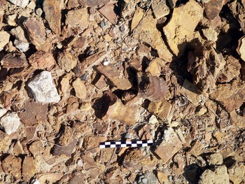
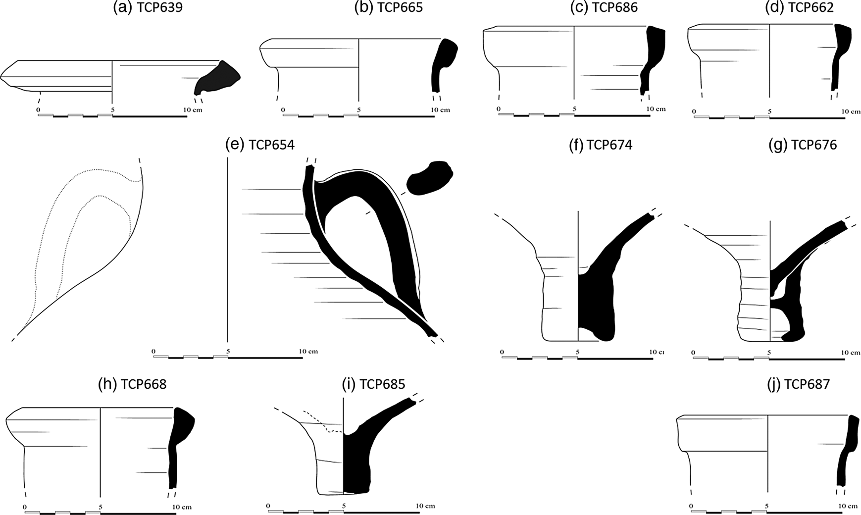
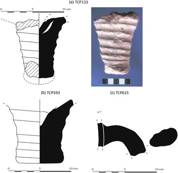
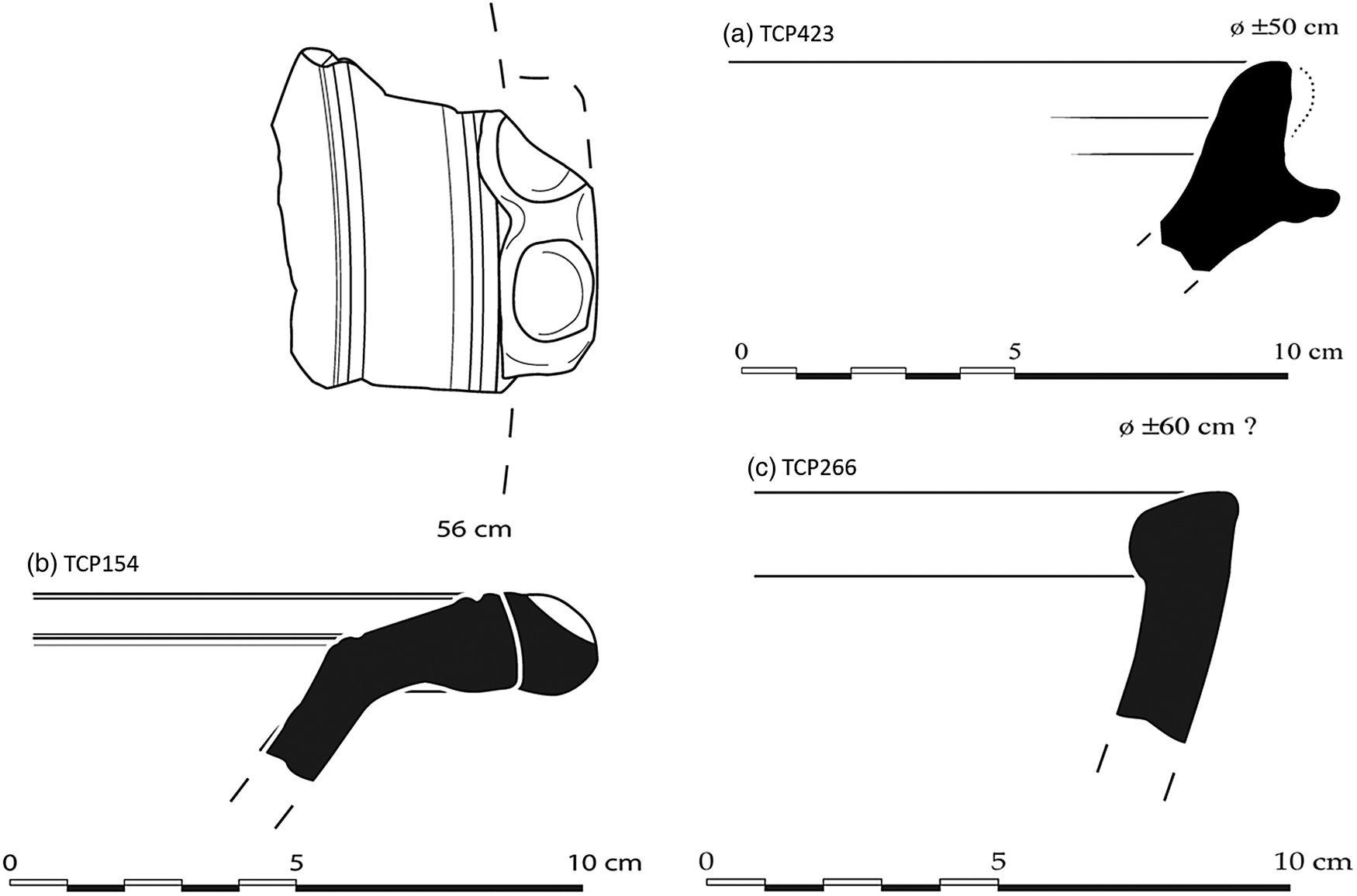
The fabric of the tiles and large coarse wares provides an excellent basis to explore the types of pottery produced in the region of the TAESP area. Tiles and pithoi are two types of pottery less likely to travel far from their production sites, although notable exceptions to this rule have been recorded, e.g. tiles from Salamis and Paphos recorded at Kalavasos-Kopetra (Rautman et al. Reference Rautman, Gomez, Neff and Glascock1993; Reference Rautman, Neff, Gomez, Vaughan and Glascock1999). Numerous tiles were collected by TAESP, dominated by two general types: a coarse dark reddish-brown type fired at low temperatures and a self-slipped type of a better-sorted, harder-fired fabric. Many of the coarse wares collected by the project, especially pithos fragments, appeared to be closely related to the low-fired tiles in terms of fabric and technology, whereas other utility wares were closely associated with the self-slipped tiles on the basis of the same parameters. In order to determine if the low-fired tiles and pithoi recorded by the survey were in fact locally produced, approximately 40 samples were selected for petrographic analysis. Among this group were four pan-tile fragments from Evrychou Tomb 5 located in the Karkotis Valley in the western part of the survey area.Footnote 3 In addition, approximately 40 samples of mainly transport amphorae were analysed. The bulk of the transport amphora sample consisted of a type of amphorae (AmSK[ouriotissa]1–3) collected in the remains of a large amphora dump originally located near the Roman galleries at Skouriotissa (Winther Jacobsen Reference Winther Jacobsen, Bonifay and Treglia2007a; Boutin et al. Reference Boutin, Banks, Digney, Evans, Floridou, Gabrieli, Given, Hadjianastasis, Horowitz, Ireland, Janes, Kassianidou, Knapp, McCartney, Noller, Ntinou, Schriwer, Slevin, Urwin, Vroom and Winther-Jacobsen2013, 118–20). The sherds from the dump are covered in mineral accretions, and the walls of the vessels are completely permeated (Figs 3–4). It is highly likely that these amphorae belong to the type of vessels mentioned by the Roman physician Galen (Kühn 234) for the transport of mineral water out of the mine. The sample also included fragments of the Skouriotissa amphorae collected from the survey area in general and fragments of another type of amphora of what appeared to be a related fabric (Mav[rovouni]1–3) (Fig. 5). The Mavrovouni amphorae are a much sturdier version of the Skouriotissa amphorae (Winther-Jacobsen Reference Winther-Jacobsen2013b, 67). Finally, a few other fragments of similar as well as clearly different fabrics were added.
Skouriotissa amphorae (AmSk) at the dumped location (photo by author).

Skouriotissa amphorae (AmSk) (copyright TAESP).

Mavrovouni amphorae (Mav) (copyright TAESP).

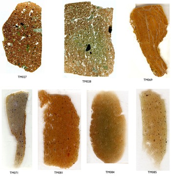
Even if no kilns could be identified, the petrographic analyses of the fabrics demonstrate clearly that the low-fired tiles, pithoi and other coarse wares, as well as the two hard-fired, sampled amphora types, originate in the northern Troodos foothills.Footnote 4 This is recognisable by the combination of pyroxene, feldspar and plagioclase from the ultra-basic rocks of the Troodos Mountains and volcanic glass from the pillow lavas, as well as the smaller quantity of foraminifera and amphiboles, which are more abundant in the western Troodos (Fig. 6). The ceramics from Evrychou Tomb 5 provide evidence that it was not only tiles and heavy utility wares that were produced in the low-fired north-western Troodos fabric, but also cooking wares and light utility wares such as plain bowls (Winther-Jacobsen Reference Winther-Jacobsen, Spataro and Villing2015). The production is not restricted to low-fired ceramics. The Skouriotissa and Mavrovouni amphorae are produced in the better-levigated version of the north-western Troodos fabric, and their similarity with the harder fired, self-slipped tiles and utility wares suggests that these also originate within this area.Footnote 5 The distribution of the individual regional and imported pottery types, the chronotypes, provide the basis for mapping connectivity within the TAESP area as well as beyond.
Thin sections of Tile and AmSk fragments (copyright TAESP).

The aim of the present article is to identify the connections between the copper-producing hinterland and the coast as well as the lands beyond, and in this sense there is an overlap with the current focus on the notion of insularity (Broodbank Reference Broodbank2000, 21–5; see Gordon Reference Gordon and Kouremenos2018). However, for the Roman period I find the concept of connectivity more productive ‘to think with’. In archaeology, connectivity provides a way to describe the physical and conceptual degree of interconnectedness and inter-relatedness between different sites and their populations (Lynch and Matter Reference Lynch, Matter and Oakley2014, 107). Peregrine Horden and Nicolas Purcell (Reference Horden and Purcell2000, 123) described the concept of connectivity as the ways which micro-regions cohere internally as well as interdependently in aggregates ranging in size from small clusters to something approaching the entire Mediterranean. Networks transcend the dualism between physical and relational space, and basic network theory is applied to move from circulation to connectivity by mapping the flow of individual pottery types between sites. I follow the definition of networks by Rivers, Knappett and Evans (Reference Rivers, Knappett, Evans, Bevan and Lake2016, 100), who identify nodes with archaeological sites and the communities that inhabited these sites, and links with the acts of exchange between them. Network theory also provides a tool to establish a simple site hierarchy associated with understanding the intensity of centrality as the sum of interactions with other places (Taylor, Hoyler and Verbruggen Reference Taylor, Hoyler and Verbruggen2010, 2809–10). In the discussion of the settlement hierarchy, I follow the ranking for the Late Roman period of Vionis and Papantoniou (Reference Vionis, Papantoniou, Cau Ontivero and Mas Florit2019, 269), rather than model for the Roman period by Rupp (Reference Rupp, Aufrecht, Nirau and Gauley1997, 243–6). The data derive from the survey of artificial units known as plough soil assemblages. Plough soil assemblages are the sub-surface population of material evidence potentially available to the survey archaeologist represented at any given moment by the surface samples (Winther-Jacobsen Reference Winther-Jacobsen2010, 42). They consist of clusters of material evidence, typically in the form of pottery fragments relating to not a single ‘functional moment’, but many ‘functional moments’ (Wandsnider Reference Wandsnider, Alcock and Cherry2004, 51–3). Plough soil assemblages have depositional and post-depositional histories different from excavated assemblages. However, patterning has not been completely obliterated by the process of formation; it has been obscured in a predictable way allowing archaeologists to treat surface collections as assemblages in order to explore their meaning (Winther-Jacobsen Reference Winther-Jacobsen2010, 42–3). The survey assemblages are recorded as survey units mapped in GIS providing the contextual setting within the landscape. The next part of the article analyses the dynamics of the settlement pattern in the TAESP landscape by mapping the links between the Late Roman sites based on the circulation of regional and imported ceramic types.
SETTLEMENT PATTERN AND CONNECTIVITY IN THE SKOURIOTISSA HINTERLAND
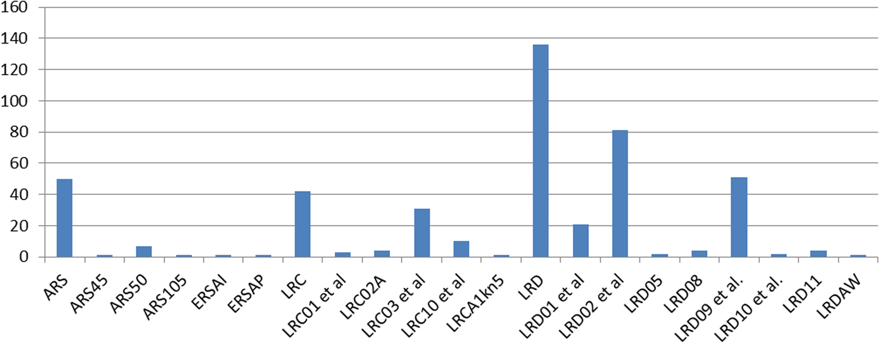
Traditionally, the Roman periodisation of survey material is based mainly on imported table wares, and this study is no different. Just over half of the Middle to Late Roman table ware fragments from the entire survey area (228 out of 454) are body sherds, whose ware but not individual form could be identified. Consequently, the detailed chronology is based on half the finds only. The three most common Late Roman table ware forms (including subtypes) are LRC form 3, LRD form 2 and LRD form 9. This suggests that the Late Roman rural expansion in the Skouriotissa hinterland started in the early fifth century and culminated around the middle of the sixth century, tapering off probably into the eighth century or possibly even later (Armstrong Reference Armstrong and Mango2009). This pattern of culmination is broadly consistent with the results of other surveys in Cyprus although it fluctuates in the decades before and after the middle of the sixth century (Moore Reference Moore2003, 281; Rautman Reference Rautman, Stewart, Davis and Weyl Carr2014, 44).
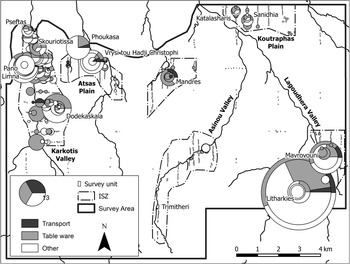
Mapping of the ceramic finds reveals that the Late Roman period features the most widely diffused settlement pattern in the TAESP survey area until pre-modern times (c. 1700) (Fig. 7). This correlates well with recent finds suggesting that this is also the period of greatest activity of the Cypriot copper industry (Kassianidou, Agapiou and Manning Reference Kassianidou, Agapiou and Manning2021). For the distribution map, the Late Roman pottery has been functionally differentiated into three categories: table wares, transport amphorae and others. The functional differentiation provides an immediate impression of the character of the assemblages. The category ‘others’ includes pottery originally sorted into architectural, cooking, heavy and light utility ceramics, which are mainly of regional production. Except for the Karkotis Valley, where the distribution of Late Roman pottery is diffused across the landscape, concentrations of transport amphorae and table wares are mainly associated with sites identified by additional features or high densities and combinations of finds. The distribution map illustrates the ceramics basis for isolating 12 secure Late Roman sites. Outside of the areas defined as sites, the Late Roman component is either not discrete or does not rise sufficiently above the diachronic background noise. For instance, in the upper Asinou Valley, the low-density Late Roman site of Nikitari-Trimitheri has been identified on the basis of structures and discreteness. There was certainly Late Roman-period activity in the lower Asinou Valley at the church Panayia Phorviotissa and Nikitari-Khalospities, where there are also Medieval settlements, but there is neither distinctiveness nor adequate diversity of assemblage to identify and precisely locate a Late Roman settlement (Gibson et al. Reference Gibson, Banks, Digney, Evans, Floridou, Gabrieli, Given, Hadjianastasis, Ireland, McCartney, Noller, Robins, Schriwer, Sollars, Urwin, Vroom and Winther-Jacobsen2013, 211).
Map of the TAESP area showing the distribution of the Late Roman pottery functionally differentiated into three categories: table wares, transport amphorae and others. The latter includes all pottery originally sorted into architectural, cooking, heavy and light utility ceramics (map by L. Sollars and M. Given; copyright TAESP).

The sites
The discussion of the connectivity within the Skouriotissa hinterland is based on 12 Late Roman sites distributed across the TAESP landscape. Geographically, Katydata-Pano Limna, Skouriotissa(-Vouppes) and Skouriotissa-Pseftas are located at the northern end of the Karkotis Valley, Phlasou-Dodekaskala in the central Karkotis Valley, Nikithari-Trimitheri deep in the Troodos foothills, Petra-Phoukasa and Linou-Vrysi tou Hadji Christophi on the Atsas Plain, Kato Koutraphas-Mandres on the upper Koutraphas Plain, Pano Koutraphas-Sanidhia and Pano Koutraphas-Katalasharis on the lower Koutraphas Plain north of the Lagoudhera Valley, where Xyliatos-Litharkies and Ayia Marina-Mavrovouni are located (Fig. 1).
The sites can be sorted into four groups determined by their method of identification: sites identified as discrete clusters of mainly ceramics associated with one or more features in situ such as Skouriotissa, Phoukasa, Vrysi, Trimitheri, Litharkies and Mavrovouni; sites identified as discrete clusters of mainly ceramics such as Sanidhia and Katalasharis; sites identified as more diffused scatters of mainly ceramics associated with features in situ such as Pano Limna and Pseftas; and sites identified as more diffused but dense scatters of mainly ceramics with no associated features in situ such as Dodekaskala and Mandres. The discreteness is not absolutely calculated as it is relative to the background noise and must be supported by diversity of assemblage. In the Karkotis Valley where there has been continuous settlement since ancient times, the background noise of ceramics from different periods is higher, and consequently densities have to be relatively higher to be noticeable. In areas with no settlement in the surrounding periods, clusters stand out clearly.
The features in situ are typically associated with mining, agriculture and/or settlement. Skouriotissa and Mavrovouni are associated with slag heaps (Boutin et al. Reference Boutin, Banks, Digney, Evans, Floridou, Gabrieli, Given, Hadjianastasis, Horowitz, Ireland, Janes, Kassianidou, Knapp, McCartney, Noller, Ntinou, Schriwer, Slevin, Urwin, Vroom and Winther-Jacobsen2013, 114–35; Graham et al. Reference Graham, Banks, Digney, Evans, Gabrieli, Given, Hadjianastasis, Kassianidou, Lufafa, McCartney, Ntinou, Urwin, Vroom and Winther-Jacobsen2013, 178–82); Pseftas and Litharkies are associated with adits (Boutin et al. Reference Boutin, Banks, Digney, Evans, Floridou, Gabrieli, Given, Hadjianastasis, Horowitz, Ireland, Janes, Kassianidou, Knapp, McCartney, Noller, Ntinou, Schriwer, Slevin, Urwin, Vroom and Winther-Jacobsen2013, 138–41; Graham et al. Reference Graham, Banks, Digney, Evans, Gabrieli, Given, Hadjianastasis, Kassianidou, Lufafa, McCartney, Ntinou, Urwin, Vroom and Winther-Jacobsen2013, 157–69); Pano Limna, Phoukasa, Vrysi, and Trimitheri are associated with remains of walls (Boutin et al. Reference Boutin, Banks, Digney, Evans, Floridou, Gabrieli, Given, Hadjianastasis, Horowitz, Ireland, Janes, Kassianidou, Knapp, McCartney, Noller, Ntinou, Schriwer, Slevin, Urwin, Vroom and Winther-Jacobsen2013, 105–14; Given et al. Reference Given, Banks, Boutin, Digney, Evans, Floridou, Gabrieli, Hadjianastasis, Horowitz, Ireland, Janes, Kassianidou, Knapp, McCartney, Noller, Schriwer, Slevin, Urwin, Vroom and Winther-Jacobsen2013c, 12–17); Phoukasa and Litharkies with cisterns; and Vrysi and Pseftas with mill stones (Given et al. Reference Given, Banks, Boutin, Digney, Evans, Floridou, Gabrieli, Hadjianastasis, Horowitz, Ireland, Janes, Kassianidou, Knapp, McCartney, Noller, Schriwer, Slevin, Urwin, Vroom and Winther-Jacobsen2013c, 12–16; Boutin et al. Reference Boutin, Banks, Digney, Evans, Floridou, Gabrieli, Given, Hadjianastasis, Horowitz, Ireland, Janes, Kassianidou, Knapp, McCartney, Noller, Ntinou, Schriwer, Slevin, Urwin, Vroom and Winther-Jacobsen2013, 139–40).
The interpretation of the smelting site at Skouriotissa is unmistakable. In the 1920s the size of the Skouriotissa slag heap was recorded as 670 m long, 20 m high, and 30–90 m deep (Hills Reference Hills1928, 56; Lavender Reference Lavender1962, 63). Together with nearby Mavrovouni, the waste pile from the copper smelting is now approximately 300 m long and estimated at 54,000 m3, or 2 million tons of slag (Bruce Reference Bruce1937, 642). The type of slag found at Skouriotissa is associated with the Roman period (Kassianidou Reference Kassianidou2003, 223–4). Radiocarbon and dendrochronological data suggest the accessible part of the slag heap was built up from the late third/possibly early to mid-fourth to the mid-to-late seventh century (Manning Reference Manning2013, 49, 54). This is important new knowledge because it was previously believed that the mines were not exploited during the Late Antique period (Walsh Reference Walsh1927, 105; des Gagniers Reference Gagniers1985, XXVII). Recently, a Late Hellenistic–Early Roman section, which was part of a different slag heap, was discovered higher up in the crater of the open cast mine (Kassianidou, Agapiou and Manning Reference Kassianidou, Agapiou and Manning2021). On the basis of proportional distribution, ratios of the different classes of ceramics, identified features, location, and context, Litharkies and Mavrovouni have been identified as non-agricultural production sites associated with mining and Sanidhia and Katalasharis as small agricultural production sites (Winther-Jacobsen Reference Winther-Jacobsen2010, 71–97; see also Graham, Winther Jacobsen and Kassianidou Reference Graham, Winther Jacobsen and Kassianidou2006; Graham et al. Reference Graham, Banks, Digney, Evans, Gabrieli, Given, Hadjianastasis, Kassianidou, Lufafa, McCartney, Ntinou, Urwin, Vroom and Winther-Jacobsen2013, 160–72, 177–94; Sollars et al. Reference Sollars, Boutin, Banks, Digney, Evans, Floridou, Gabrieli, Given, Hadjianastasis, Horowitz, Ireland, Janes, Kassianidou, Knapp, McCartney, Noller, Ntinou, Schriwer, Slevin, Urwin, Vroom and Winther-Jacobsen2013). The interpretation of the remaining sites is more intuitive and less quantifiable. Dodekaskala and Pano Limna are interpreted as associated with multiple settlements (Boutin et al. Reference Boutin, Banks, Digney, Evans, Floridou, Gabrieli, Given, Hadjianastasis, Horowitz, Ireland, Janes, Kassianidou, Knapp, McCartney, Noller, Ntinou, Schriwer, Slevin, Urwin, Vroom and Winther-Jacobsen2013, 78–82, 105–14); Phoukasa and Mandres as agricultural production sites (Given et al. Reference Given, Banks, Boutin, Digney, Evans, Floridou, Gabrieli, Hadjianastasis, Horowitz, Ireland, Janes, Kassianidou, Knapp, McCartney, Noller, Schriwer, Slevin, Urwin, Vroom and Winther-Jacobsen2013c, 16–17, 38); Pseftas and Trimitheri as small productions sites (Boutin et al. Reference Boutin, Banks, Digney, Evans, Floridou, Gabrieli, Given, Hadjianastasis, Horowitz, Ireland, Janes, Kassianidou, Knapp, McCartney, Noller, Ntinou, Schriwer, Slevin, Urwin, Vroom and Winther-Jacobsen2013, 138–41; Gibson et al. Reference Gibson, Banks, Digney, Evans, Floridou, Gabrieli, Given, Hadjianastasis, Ireland, McCartney, Noller, Robins, Schriwer, Sollars, Urwin, Vroom and Winther-Jacobsen2013, 211–13); and Vrysi as a cultic site associated with agricultural production, a so-called agro-church (Winther-Jacobsen Reference Winther-Jacobsen2010, 71–97; see also Given et al. Reference Given, Banks, Boutin, Digney, Evans, Floridou, Gabrieli, Hadjianastasis, Horowitz, Ireland, Janes, Kassianidou, Knapp, McCartney, Noller, Schriwer, Slevin, Urwin, Vroom and Winther-Jacobsen2013c, 12–16).
Although the Late Roman assemblages are predominant at Skouriotissa, Pseftas, Trimitheri, Phoukasa, Vrysi, Sanidhia, Katalasharis, Litharkies and Mavrovouni, the chronology is complex. Late Hellenistic to Early Roman as well as some Post-Roman sherds have been recorded at all the sites, and at Dodekaskala, Mandres and Pano Limna where the Late Hellenistic to Early Roman element is strong. The pottery of the earlier period is represented mainly by table wares and some cooking wares (Winther-Jacobsen Reference Winther-Jacobsen2013b, 63–4; Reference Winther-Jacobsen2013c, 333). A sample of charcoal collected in the central part of the slagheap at Mavrovouni produced a calibrated date of 416–533 (Graham et al. Reference Graham, Banks, Digney, Evans, Gabrieli, Given, Hadjianastasis, Kassianidou, Lufafa, McCartney, Ntinou, Urwin, Vroom and Winther-Jacobsen2013, 180).
Several Early Roman tombs and possible necropoleis have also been identified in the TAESP landscape. Six tombs have been identified on the basis of looted structures at Evrychou, Skouriotissa and Katydata (Boutin et al. Reference Boutin, Banks, Digney, Evans, Floridou, Gabrieli, Given, Hadjianastasis, Horowitz, Ireland, Janes, Kassianidou, Knapp, McCartney, Noller, Ntinou, Schriwer, Slevin, Urwin, Vroom and Winther-Jacobsen2013, 141–3, table 3:35). At Litharkies, a pile of large fragments of the types of pottery typically associated with tombs was identified by a depression in the ground on the outskirts of the Litharkies settlement, which is interpreted as a looted tomb (Graham et al. Reference Graham, Banks, Digney, Evans, Gabrieli, Given, Hadjianastasis, Kassianidou, Lufafa, McCartney, Ntinou, Urwin, Vroom and Winther-Jacobsen2013, 169). Some diffused scatters of ceramics have been interpreted as necropoleis on the basis of the proportional distribution of different types of ceramics and their proximity to known looted tombs (e.g. at Katydata and possibly also at Pano Limna: Boutin et al. Reference Boutin, Banks, Digney, Evans, Floridou, Gabrieli, Given, Hadjianastasis, Horowitz, Ireland, Janes, Kassianidou, Knapp, McCartney, Noller, Ntinou, Schriwer, Slevin, Urwin, Vroom and Winther-Jacobsen2013, 98, 114). Kassianidou, Agapiou and Manning (Reference Kassianidou, Agapiou and Manning2021, fig. 4) were recently able to identify a large cemetery adjacent to the Skouriotissa slag heap; although its location suggests a Roman date, there is no way to prove this since the area is buried under the leaching heaps. However, it seems likely that the area is connected with the nine Roman tombs excavated by Menelaos Markides (Reference Markides1916) at Apoti, east of the Skouriotissa Monastery, close to the eastern side of the road between Katydhata and Skouriotissa in an area full of looted tombs. In Cyprus, Late Roman tombs included very little pottery, and of course, Christian burials become associated with churches. Since there is probably a high degree of continuity of activity, the early churches and their necropoleis are most likely overbuilt, but there is a remarkable absence of positively recorded early Christian churches in north-western Cyprus and the Troodos Mountains (Kyriakou Reference Kyriakou, Papanotniou, Morris and Vionis2019, 60–1 and fig. 6). South of the Mavrovouni slagheap, a small church, Agios Kyriakos, is preserved in name only (Goodwin Reference Goodwin1984, 176), and may not have been the first church on the site. However, later churches at ancient rural metallurgical sites are common (Given Reference Given, Nevett and Whitley2018, 172).
The selected sites are clustered within distinctive settlement chambers in the Karkotis and the Lagoudhera valleys, and on the Koutrafas and Atsas plains. Large areas of land with desirable resources delimited by natural boundaries sustain community areas, and network theory allows us to explore the links across the environments. In order to understand the relationship between the selected sites, we turn to the most prolific archaeological source in the landscape, the pottery.
The pottery
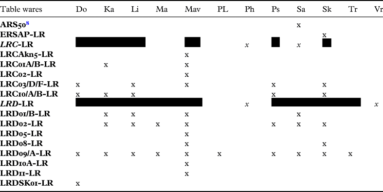
The distribution of Late Roman pottery in the TAESP landscape supplies evidence for connectivity in the form of a high level of ceramic homogeneity not only in terms of chronotypes broadly defined by ware and/or style such as Late Roman D red slipped wares, but also chronotypes recorded as distinctive types on the basis of fabric, surface treatment, style, manufacturing technology, and morphology such as Late Roman D form 10.Footnote 6 Imported types of pottery alone are not a strong indication of connectivity at a local level, but the high level of ceramic homogeneity also applies to ceramics, which are identified as produced in the region of the north-western Troodos foothills on the basis of petrographic analysis, e.g. the Mavrovouni amphorae (Mav1–3).
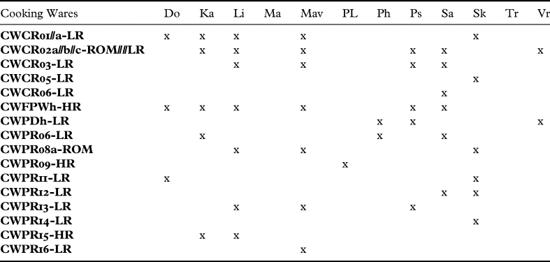
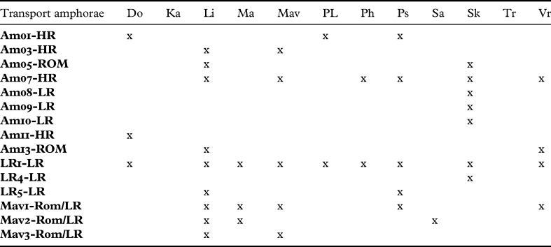
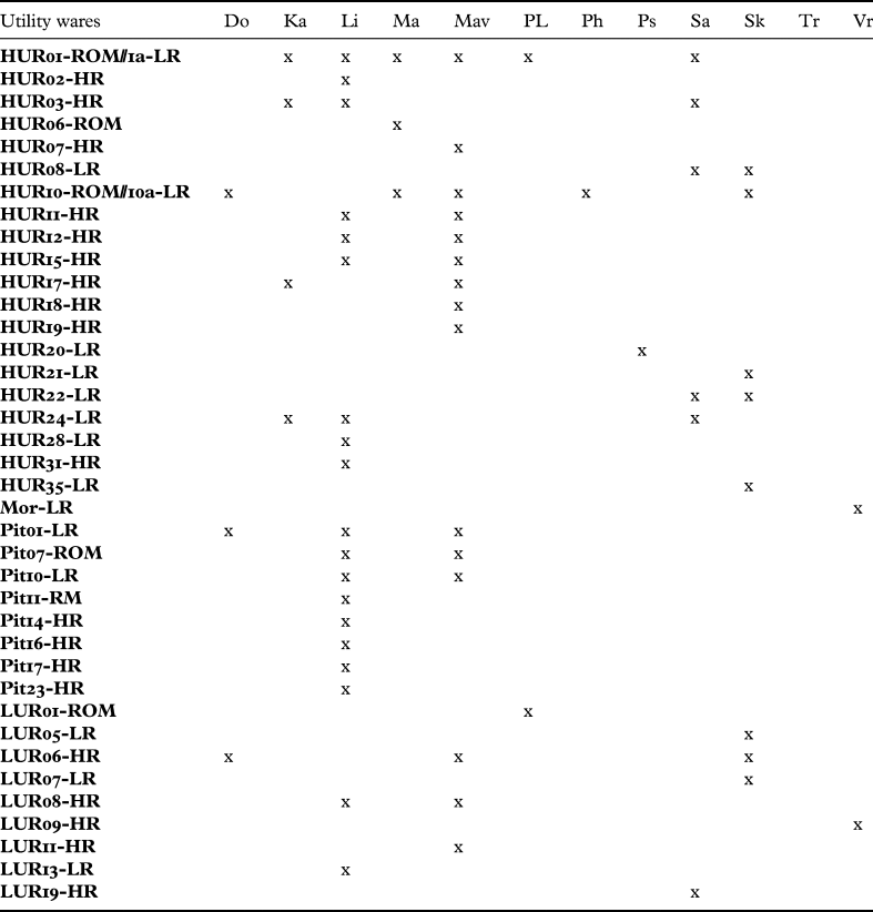
Tables 1–4Footnote 7 record all the non-generic Late Roman/Roman chronotypes occurring at the sites. The non-generic chronotypes have been recorded as distinctive types on the basis of fabric, surface treatment, style, manufacturing technology, and morphology. Some are well-published types such as LR1 (Late Roman Amphorae Type 1); others are locally defined such as Pit01 (Pithos type 1). Thirty-one out of 65 locally defined chronotypes occur at more than one of the sites. At three sites only body sherds of LRC and LRD have been recorded, and at these sites these ‘undiagnostic’ sherds have been counted once since they could be attributed to any of the diagnostic types of the same wares. In order to illustrate the broader ceramic context, the tables include also the 40 chronotypes which only occur at one of the sites. Twenty-four of these are locally defined utility and cooking wares such as Pit11. Nine of the transport amphorae chronotypes have found no parallels, but the fabric clearly denotes them as imports. Concerning the chronology, 42 out of 80 chronotypes are dated specifically to the Late Roman period, while those remaining cannot be dated more precisely. The dates of the regional types (such as pithoi) most likely overlap with the preceding and following periods.
Distribution of cooking ware chronotypes. Table legend of sites: Do: Dodekaskala, Ka: Katalasharis, Li: Litharkies, Ma: Mandres, Mav: Mavrovouni, PL: Pano Limna, Ph: Phoukasa, Ps: Pseftas, Sa: Sanidhia, Sk: Skouriotissa, Tr: Trimitheri, Vr: Vrysi. For the definitions of chronotypes see Winther-Jacobsen et al. Reference Winther-Jacobsen, Gabrieli, Horowitz, Janes, Sollars and Vroom2013b; all types are illustrated in the catalogue.

Distribution of table ware chronotypes. Table legend of sites: Do: Dodekaskala, Ka: Katalasharis, Li: Litharkies, Ma: Mandres, Mav: Mavrovouni, PL: Pano Limna, Ph: Phoukasa, Ps: Pseftas, Sa: Sanidhia, Sk: Skouriotissa, Tr: Trimitheri, Vr: Vrysi. For the definitions of chronotypes see Winther-Jacobsen et al. Reference Winther-Jacobsen, Gabrieli, Horowitz, Janes, Sollars and Vroom2013b; all types are illustrated in the catalogue. Types in italics are body fragments which could not be assigned a form.

Distribution of transport amphora chronotypes. Table legend of sites: Do: Dodekaskala, Ka: Katalasharis, Li: Litharkies, Ma: Mandres, Mav: Mavrovouni, PL: Pano Limna, Ph: Phoukasa, Ps: Pseftas, Sa: Sanidhia, Sk: Skouriotissa, Tr: Trimitheri, Vr: Vrysi. For the definitions of chronotypes see Winther-Jacobsen et al. Reference Winther-Jacobsen, Gabrieli, Horowitz, Janes, Sollars and Vroom2013b; all types are illustrated in the catalogue.

Distribution of utility ware chronotypes. Table legend of sites: Do: Dodekaskala, Ka: Katalasharis, Li: Litharkies, Ma: Mandres, Mav: Mavrovouni, PL: Pano Limna, Ph: Phoukasa, Ps: Pseftas, Sa: Sanidhia, Sk: Skouriotissa, Tr: Trimitheri, Vr: Vrysi. For the definitions of chronotypes see Winther-Jacobsen et al. Reference Winther-Jacobsen, Gabrieli, Horowitz, Janes, Sollars and Vroom2013b; all types are illustrated in the catalogue.

There is a strong correlation between the size of the assemblage and the number of chronotypes recorded (Winther-Jacobsen Reference Winther-Jacobsen2010, 75, table 8). Among the selected sites, the site with the smallest number of chronotypes collected also has the fewest links and vice versa (Trimitheri and Litharkies, respectively, which are incidentally also the two most remote sites), but the number of links connecting the sites in between is not ordered according to the number of sherds (for instance, compare Skouriotissa with Katalasharis and Sanidhia: Table 5). The correlation between the size of the assemblage and the number of chronotypes is also affected by depositional and post-depositional processes; this is because the better the state of preservation of the finds the more chronotypes are likely to be identified, which should affect both Skouriotissa and Vrysi.
Correlation between number of links, imported and local non-generic chronotypes.

The network
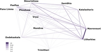
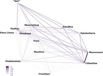
All the Late Roman sites are connected by ceramic links, although some sites are linked by the co-occurrence of one or two non-generic chronotypes only: the mean number of links is 4.3 and the median is 3. The highest number is 23 links (Table 5, Fig. 8). Before discussing the meaning of the links, the basic supposition must be clarified: a high number of links indicating that some sites are more closely connected than others are because the people associated with these sites move between them and bring goods or produce similar goods during a specific period in time.
Network of chronotypes. The scale indicates the number of connections occurring between the individual sites.

There are two main ways of sorting the data in Table 5: either according to the number of links or by ratio of chronotypes to links as a way of understanding the correlation between the number of chronotypes and the number of links. In both, all the sites fall into three clusters. Sorted according to links: Litharkies and Mavrovouni (88–93 links); Katalasharis, Pseftas, Sanidhia and Skouriotissa (54–62 links); Dodekaskala, Mandres, Pano Limna, Phoukasa and Vrysi (26–47 links). Sorted according to the ratio of chronotypes to links: Litharkies, Mavrovouni and Skouriotissa (>0.40); Dodekaskala, Katalasharis, Sanidhia and Vrysi (0.26–32); Mandres, Pano Limna, Phoukasa and Pseftas (0.19–23).
Missing from both classifications is Trimitheri, which is not surprising since it is located deep in the Troodos foothills. The single link, which is shared with all the other sites, is an import, and it demonstrates mainly how deeply into the hinterland imports penetrated. Although the evidence comes from one site only it does correlate well with the observations by Sue Alcock on Late Roman Greece. The evidence from surveys in Greece suggests that after a period of retraction during the Early Roman period, the settlement pattern of the Late Roman period again took advantage of more marginal land (Alcock Reference Alcock1993, 33–48). In Cyprus, the high imperial period of the late second through the fourth century is largely an urban phenomenon (Rautman Reference Rautman and Callaway2001; see also Lund Reference Lund, Jakubiak and Łajtar2020a), and the Late Roman rural expansion occurred in the fifth–sixth centuries (Rautman Reference Rautman2000, 317). An example of the pressure on more marginal land is demonstrated in the Akamas Peninsula, which appears to be sparsely populated with small farmsteads from Hellenistic times onwards with an expansion from the fourth century culminating towards the mid-sixth century (Fejfer and Hayes Reference Fejfer, Hayes and Wallace1995, 67). The one LRD form 9A fragment found together with a body fragment of a thin-walled corrugated cooking vessel at Trimitheri suggests a late occupation of the site in the mid- to second half of the sixth century (Gibson et al. Reference Gibson, Banks, Digney, Evans, Floridou, Gabrieli, Given, Hadjianastasis, Ireland, McCartney, Noller, Robins, Schriwer, Sollars, Urwin, Vroom and Winther-Jacobsen2013, 212).
Supported by other features such as adits and the slagheap associated with the two sites, the extraordinarily close connections between Mavrovouni and Litharkies suggest their conglomeration as a single mining centre. The 23 links between these two sites are almost twice as many as between any other sites. Both sites qualify as hubs themselves, but their truly decentralised location deep in the Lagoudhera Valley suggests that they are consumer sites rather than redistribution sites, especially Litharkies. The number of links between the mining centre in the Lagoudhera Valley and the agricultural sites on the Koutraphas Plain, Katalasharis and Sanidhia suggests a very close connection, and one interpretation of this is the need for agricultural produce at the mining centre. However, this may also be an issue of topography since the road out of the Lagoudhera Valley would have crossed the lower Koutraphas Plain. Given its topography and proximity, Mandres could also have been part of the network of the Lagoudhera Valley mining centre, but the pottery collected around Mandres is poorly preserved (for instance, no cooking wares have been chronotypologised).
Mavrovouni and Litharkies also have a strong link with Skouriotissa and Pseftas, two very different sites. Skouriotissa scores high on ratio (the highest) but less on the actual number of links. Pseftas, which is a small site just west of Phoukasa Hill, reveals a higher number of links than Skouriotissa, but scores in the lowest group when it comes to ratio. In this north-western part of the network, it is tempting to reconstruct the small agricultural settlements surrounding Skouriotissa (Phoukasa, Vrysi, Mandres, possibly Pseftas) as an agricultural supply network for this mine. One type of agricultural container, the Mavrovouni amphorae (Mav1–3), specifically ties the mining settlements in the Lagoudhera Valley to the Skouriotissa area. As a local type with a regional distribution it seems significant that within the TAESP landscape it should occur at Mavrovouni and Litharkies, at Mandres and Sanidhia, and at Pseftas and Vrysi.Footnote 9 However, the close connections recorded between the mining centre in the Lagoudhera Valley and the agricultural production sites on the Koutraphas Plain cannot be observed between Skouriotissa and its potential agricultural supply sites in the north-western corner of the network. This difference can be interpreted in two ways: either the close connection between the mining centre in the Lagoudhera Valley and the agricultural production sites on the Koutraphas Plain is related to infrastructure rather than supply system, or the supply system of Skouriotissa was different. There is some evidence to suggest that Skouriotissa was different. Although the number and the diversity are far from overwhelming, more types of transport amphorae have been recorded here than at any other site in the area (Table 2), which may indicate that the Skouriotissa workforce was at least to some extent fed from the outside world. Certainly, the penetration of the imported table wares deep into the mountains in general suggests a strong connection with the outside world.
Pano Limna scores very low on the number of links, especially considering the location in the lower Karkotis Valley less than 1.5 km south-west of the mine and the interpretation of this site as a village. The site is interesting because it partly coincides with an Archaic sanctuary, but there are no positive finds to suggest a Roman sanctuary (Boutin et al. Reference Boutin, Banks, Digney, Evans, Floridou, Gabrieli, Given, Hadjianastasis, Horowitz, Ireland, Janes, Kassianidou, Knapp, McCartney, Noller, Ntinou, Schriwer, Slevin, Urwin, Vroom and Winther-Jacobsen2013, 109–14). Tønnes Bekker-Nielsen (Reference Bekker-Nielsen2004, 147–8, 210–11) suggests that the Roman road from Soli to Kourion ran on the western side of the Karkotis River where Pano Limna is located. This is not supported by the distribution of finds recorded by TAESP in the central Karkotis Valley, where settlements and tombs appear to have been consistently located on the eastern side of the river, e.g. Dodekaskala, Phlasou and Evrychou (Winther-Jacobsen Reference Winther-Jacobsen2013c, 331).
The Karkotis Valley is very fertile and must have always been an attractive area to settle. The evidence from the Prehistoric period suggests that people initially settled on small knolls above the valley floor (e.g. Boutin et al. Reference Boutin, Banks, Digney, Evans, Floridou, Gabrieli, Given, Hadjianastasis, Horowitz, Ireland, Janes, Kassianidou, Knapp, McCartney, Noller, Ntinou, Schriwer, Slevin, Urwin, Vroom and Winther-Jacobsen2013, 71–8), but since there is no evidence of continuity the settlement pattern changed in the historical period. The strongest settlement evidence comes from the tombs recorded in the Cyprus Survey Records along the eastern edge of the valley around Evrychou, Phlasou and Linou, three possible candidates for the three Roman mining villages reconstructed by T.B. Mitford (Fig. 1). Along with Katydata, they are located on the bedrock of ridgelines jutting out of the bank of the Karkotis River (Boutin et al. Reference Boutin, Banks, Digney, Evans, Floridou, Gabrieli, Given, Hadjianastasis, Horowitz, Ireland, Janes, Kassianidou, Knapp, McCartney, Noller, Ntinou, Schriwer, Slevin, Urwin, Vroom and Winther-Jacobsen2013, 54). According to a very fragmentary inscription, the imperial administrator of the mines employed a local company of contractors from possibly three mining villages, one of which was Phlasou, to work the Soli copper mines.Footnote 10 The inscription attests to the close connection between the mine and the settlements in its hinterland in Roman times. The name of Phlasou is reconstructed in two additional cases, providing historical evidence for the hinterland settlements: Mitford (Reference Mitford1980, 1327) reconstructed it on a late third-century BC graffito from Kafizin (Nicosia district) and on a fragmentary inscription from Soli collected by Alfred Westholm (Mitford Reference Mitford1950, 12–13, n. 2).
Today a village by the name of Phlasou is located on the eastern side of the valley 3 km south of Skouriotissa, and south of Pano Phlasou the survey recorded a continuous low-density spread of Late Hellenistic–Late Roman pottery, which may be associated with the ancient settlement (Winther-Jacobsen Reference Winther-Jacobsen2013c, 333–4). Tombs have been recorded along the eastern side of the valley, few of which have been properly excavated.Footnote 11 They date from the Archaic to the Early Roman period. None of the entries in the Cyprus Survey Records mention specifically Hellenistic finds, but the first phases of Tomb 4 excavated by Ino Nicolaou, as well as the above-mentioned Tomb 5 excavated by Giorgos Georgiou both date to the Early Hellenistic period (Winther-Jacobsen Reference Winther-Jacobsen2022a). Both tombs continued to be reused through the Early Roman period as is common for Hellenistic tombs in Cyprus (Parks Reference Parks1999). They are certainly well-equipped with, amongst other material, extravagant glass vessels, although there is also in these contexts a much lower focus on imported food products compared to tombs in the coastal areas (Winther Jacobsen Reference Winther Jacobsen, Malfitana, Poblome and Lund2007b). I. Nicolaou (Reference Nicolaou1984, n. 2) mentions remains of a Roman settlement at Varkakes; however, the locality of Evrychou Tomb 5 is Varkakioes, and if this is the same locality it is possible that the finds mentioned by Nicolaou came from looted tombs rather than a settlement. The survey records also mention remains of a Roman settlement under the Evrychou cemetery north-west of the modern village in the valley bottom, a location which would be unusual for tombs in the valley. The geological subdivision of the Karkotis Valley suggests a preference for ridge–river intersections for settlement (and necropoleis), terraces for primary agricultural use, and hillslopes for pasture, marginal crops and woodlands (Boutin et al. Reference Boutin, Banks, Digney, Evans, Floridou, Gabrieli, Given, Hadjianastasis, Horowitz, Ireland, Janes, Kassianidou, Knapp, McCartney, Noller, Ntinou, Schriwer, Slevin, Urwin, Vroom and Winther-Jacobsen2013, 53).
The lower and the central part of the Karkotis Valley are prime candidates for coherent Late Antique settlement systems with a large village surrounded by dependent hamlets and farms such as identified in the Xeros Valley on the south side of the Troodos Mountains (Papantoniou and Vionis Reference Papantoniou and Vionis2018; Vionis and Papantoniou Reference Vionis, Papantoniou, Cau Ontivero and Mas Florit2019); this correlates well with the reconstruction of the rural territories of the Byzantine period by Alain Ducellier (Reference Ducellier1986, 187–8; see Vionis Reference Vionis, Papantinou, Morris and Vionis2019, 76). Cost-surface analysis of the distribution of Late Medieval churches in the Karkotis Valley have revealed that during this period the villages of Katydata, Linou and Phlasou all located on the eastern edge of the valley, and Agios Epiphanios in the northern part of the valley, formed an extended village community with a shared parish church located next to the Skouriotissa slag heap (Vionis Reference Vionis, Papantinou, Morris and Vionis2019, 76; see also Papageorghiou and Bakirtzis Reference Papageorghiou and Bakirtzis2018). Evrykhou belonged to a different Late Medieval community and hosts the parish church of the associated cluster of villages. During the Late Roman period, Dodekaskala is the only high-density scatter in the Karkotis Valley apart from the sites surrounding the mine, but as mentioned above it is not discrete, and therefore difficult to interpret. In addition, the restricted selection of chronotypes represented in the Karkotis Valley is surprising for an area inhabited over such a long period of time and with such an abundance of available resources. The data from the central Karkotis Valley floor appears to be strongly affected by post-depositional processes and modern conditions rather than providing a reliable representation of the ancient settlement pattern (e.g. K. Decker Reference Decker2005; Boutin et al. Reference Boutin, Banks, Digney, Evans, Floridou, Gabrieli, Given, Hadjianastasis, Horowitz, Ireland, Janes, Kassianidou, Knapp, McCartney, Noller, Ntinou, Schriwer, Slevin, Urwin, Vroom and Winther-Jacobsen2013, 53–4). Consequently, the south-western part of the network is unlikely to be representative of the past.
The TAESP area possessed rich mineral and agricultural resources. Forty per cent of the TAESP survey area is potential arable land (Noller Reference Noller2013b, 306). In fact, Jay Noller (Reference Noller2013b, 311) associated large-scale land sculpting in the form of agricultural terracing in the lower Karkotis Valley with the Roman mining. As has been demonstrated from the Roman mining of Spain (Hirt Reference Hirt2010, 229–31), large-scale mining would have put an enormous drain on the agricultural and labour resources. Consequently, one would expect the settlements to be closely integrated in a complex network consisting of other hinterland sites, the coastal city, neighbouring regions, as well as some type of remote administrative centre of organisation, since the mines were owned most probably by the emperor.Footnote 12 The Late Roman period is the era with the most widely diffused settlement pattern with settlement activity deep inside the Troodos Mountains. All the Late Roman sites identified appear to be associated with production, either mineral or agricultural. Consequently, none of them scores high on the centrality scale in terms of multi-function (Knitter and Nakoinz Reference Knitter and Nakoinz2018, 9). The network is missing a ceramic production and redistribution centre, and there is no evidence for administration, security or cult.
THE SKOURIOTISSA HINTERLAND AND SOLI
There are no urban centres within the survey area, but geographically and topographically the TAESP area is closely connected with Soli on the coast 9 km north-west of Skouriotissa. Galen (De simplicium medicamentorum temperamentis et facultatibus 9) associates the mines with Soli by referring to them as located in the mountains of Soli (Kühn 226). Although this may be a geographical shorthand, it seems obvious that it reflects a connection at an administrative level, and of course Galen would be well-informed from his personal visit. The claim is supported by the above-mentioned inscriptions mentioning Phlasou, indicating the connection between Soli, the mines, and the hinterland settlements.
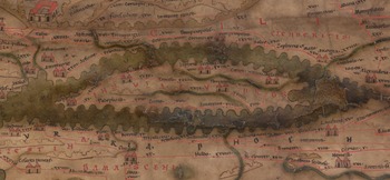
Further evidence is provided by the Tabula Peutingeriana, an itinerarium/roadmap indicating the publicly maintained infrastructure, the cursus publicus, of the Roman Empire (Fig. 9).Footnote 13 It was produced by a monk in Colmar in the thirteenth century, but its information is based on a map originating in the fourth–early fifth centuries. The legends on the map are very simple: important cities are indicated by two towers, as is Soli. Referring to the Tabula, Mitford (Reference Mitford1980, 1331) proposed Soli to be the gateway for the copper trade of the northern Troodos (see also Moore Reference Moore2003, 282). Tamassus, the city associated with the great copper mines of Mitsero south-east of Skouriotissa, is only indicated by its name, but the map shows a direct road from Tamassus to Soli, suggesting that the copper from the mines on the north side of the Troodos Mountains was shipped out there.
Cyprus and south-central Asia Minor on the Tabula Peutingeriana, Austrian National Library (available online <https://digital.onb.ac.at/RepViewer/viewer.faces?doc=DTL_2764184&order=1&view=SINGLE/> accessed October 2021).

Soli appears to have been settled in the eleventh century BC, and it was famous in Cyprus for the thousands of rich robbed tombs when the Swedish Cyprus Expeditions arrived in 1927 (Westholm Reference Westholm1936; Reference Westholm1937, 404). Soli has the third largest concentration of recorded marble sculpture in all of Cyprus (16) after Salamis (81) and Paphos (26) (Mitford Reference Mitford1950, 39, no. 19; Fejfer Reference Fejfer, Wriedt Sørensen and Winther Jacobsen2006, table 1). The city played host to at least three statues associated with imperial cult (Fujii Reference Fujii2013, 44); however, this is not an impressive record as it puts the city behind not only Salamis and Paphos, but also Curium and Lapethos. This may be associated with the late period of the city's flourishing, since 29 of the total recorded 39 imperial statues in Cyprus are dated to the period before the middle of the second century.
Owing to the Turkish invasion and consequent division of the island, the publications of the Canadian expedition from the University of Laval (1964–74) are restricted to architecture and very few finds, but according to the both the Swedish and the Canadian excavators, Soli flourished from the Antonine period until the fourth century (Westholm Reference Westholm1936, 244–6; des Gagniers Reference Gagniers1985, XXIII–XXIV; Ginouvès Reference Ginouvès1989, 60, 137). From the later second to the fourth century the urban space of Soli underwent a major reorganisation of the orthogonal layout including a paved colonnaded street, almost 5 m wide running through the city from east to west (Ginouvès Reference Ginouvès1989, 35–137). The order of the marble bases is Ionic-Attic, the capitals Corinthian, and according to the excavators, the style of the capitals belongs in the Severan period (Ginouvès Reference Ginouvès1989, 51–2). The cornice is decorated with faces between the modillions, a style comparable among others to Side and Curium (Ginouvès Reference Ginouvès1989, 57). Part of the entablature was replaced sometime after the late fourth century, as indicated by an inscription (Ginouvès Reference Ginouvès1989, 55). The original date is not secure. The colonnaded street is very poorly preserved and only in the Agora, but another inscription records the dedication of 39 columns in light grey marble originally written over two columns (Mitford Reference Mitford1950, 39, no. 19). Mitford described the latter as large and monumental with none of the Severan mannerisms, and therefore probably datable to the middle of the second century. Colonnaded streets are still rare in the archaeology of Cyprus, but they occur at least at Curium and Paphos.Footnote 14 It appears from the excavations at the agora (Ginouvès Reference Ginouvès1989, fig. 9) that the 39 columns would reach approximately 150 m from the agora placed along one side only, which is not enough to reach any of the hypothesised gates.
In the late second–early third centuries, a theatre for 2400–3000 spectators was constructed (Gjerstad Reference Gjerstad1937, 563–73, 581–2; Sear Reference Sear2010, 384). Like all theatres in Cyprus apart from Salamis, the construction of the theatre in Soli took advantage of natural terrain, but the upper cavea is supported by rubble walls. In general theatres in Cyprus have suffered heavy stone plunder, and they are also heavily rebuilt, except for the theatre in Paphos, which is undergoing excavation by an Australian team (e.g. Green and Stennett Reference Green and Stennett2002; Barker Reference Barker, Balandier, Michaelides and Raptouforthcoming).
Approximately 500 m west of the western city gate, the Swedish Cyprus Expeditions also excavated the sanctuary at Cholades, active from the middle of the third century BC until the fourth century AD (Westholm Reference Westholm1936; Reference Westholm1937; Papantoniou Reference Papantoniou2012, 167–90; Papantoniou and Vionis Reference Papantoniou and Vionis2017, 8). Six temples dating to the Hellenistic and Roman periods were excavated. According to the interpretation of the excavators, Temples A and B were dedicated to Aphrodite and Cybele, and one or possibly both of Temples C and D were sacred to Isis. The archaeology of the first two centuries AD is difficult to reconstruct, but Temple E was constructed in the middle of the third century and there is evidence for the worship of Serapis, Osiris-Canopus, Agathos-Daimon, the Dioscuri and Eros in Mourning. Temple F was possibly dedicated to Mithras, but it has recently been suggested to be a Greco-Egyptian banquet hall (Kleibl Reference Kleibl and Rogge2007, 145–9). It was constructed in the late third–early fourth centuries when also Temples B, C and E were altered. There is no evidence at Cholades for a large Greco-Roman style temple such as in the Sanctuary of Apollo Hylates outside of Kourion. In addition, Papantoniou (Reference Papantoniou2012, 167) suggests that the architectural choice of an open courtyard, which is still evident in Temple E and the altered plans of Temples B and C provides a strong link to Cypriot cultic traditions.
The Canadian expedition which excavated the Roman agora including a nymphaeum (Ginouvès Reference Ginouvès1989, 43–137) also excavated part of a Roman house with a third-century mosaic, of which the last phase is dated in the second half of the fifth century (Ginouvès Reference Ginouvès1989, 35–41), and a Late Antique basilica completely rebuilt (Tinh Reference Tinh1985; Reference Tinh1989). According to the excavators of Soli, the basilica and the agora were still in use during the fifth to seventh centuries (des Gagniers Reference Gagniers1985, XXVII–XXVIII; Ginouvès Reference Ginouvès1989, 21), and the basilica floors appear to have been redecorated more than once during the Late Antique period (Tinh Reference Tinh1985, 32–4). It so happens that the latest dendrochronological radiocarbon wiggle match analysis dates of the Skouriotissa slagheap are contemporary with the final rebuilding of the basilica in 653/4 (Manning Reference Manning2013, 50). However, the interpretation of the Soli basilicas is not straightforward.Footnote 15 The excavators identified two phases, A and B. A is of so-called Constantinian design with five aisles and an apsis decorated with mosaic floors as well as a square peristyle courtyard (the atrium) with a square fountain in the centre (Tinh Reference Tinh1985, 10–42). It measures 22.4 x 45 m. The upper building was completely destroyed by its replacement, Basilica B, but several phases of mosaic floors are preserved dating to the second half of the fourth century, when the excavators believed the basilica was built, to the fifth century, and to the second half of the fifth century. According to Arthur Megaw (Reference Megaw, Ioannides and Hadjistylli2000), this is one of the largest of the early basilicas in Cyprus apart from the urban basilicas in Paphos and Salamis. However, Megaw dated Basilica A around 330 due to the architectural style and the date of the mosaic in the apse. B is a more traditional three aisled basilica with three apses, opus sectile floors, a white marble orthostat and non-monolithic columns (Tinh Reference Tinh1985, 43–112). It also has a square peristyle courtyard with a square fountain in the centre. This basilica measures 31.5 x 53.5 m. The termination of all three aisles with apses in Basilica B is a Cypriot tradition shared with Cilicia and Isauria (Baldini Reference Baldini2013, 36–7).
The Stadiasmos Maris Magnis (311), a Roman periplus, describes Soli as a town without a harbour (Leonard Reference Leonard, Karageorghis and Michaelides1995a, 232), and the ancient harbour just north of the walled city mentioned in earlier sources (e.g. Strabo 14.6.3) is supposed to have been silted at some point during the Roman period (des Gagniers Reference Gagniers1985, XXVII). Two written sources mention landings at the harbour at Limenia 6 km west of Soli in the first and in the first to fourth centuries (Acta Sanctorum, De S. Barnabas §25 and De S. Auxibio §3; see Westholm Reference Westholm1937, 407), but given that the later second to fourth centuries are acknowledged to be the heyday of Soli, indicated by the major reorganisation of the city, it is very unlikely that the city did not have a functioning harbour during this period (des Gagniers Reference Gagniers1985, XXIII–XXIV; see also Westholm Reference Westholm1937, 410). Consequently, the silting of the harbour is believed to be a situation of the fourth–fifth centuries. In this case, the copper mined during the sixth and seventh centuries would have been shipped out from Limenia. Although the most prominent Iron Age cities of Cyprus seem to be an exception to this rule, some distance between the actual city and its harbour is of course very common in the Mediterranean world.
The almost complete absence of Late Roman pottery from the excavations of the Swedish Cyprus Expedition on the acropolis, where they recorded a very poorly preserved Hellenistic–Roman temple, and at Cholades suggests that the Late Antique settlement at the ancient site was diminished.Footnote 16 However, the basilica of Soli is evidence of Late Roman activity inside the old city, and according to the Canadian excavators, the town extended north of the acropolis towards the sea until the sixth to seventh centuries (des Gagniers Reference Gagniers1985, XXVII–XXVIII; Ginouvès Reference Ginouvès1989, 21, and see for instance p. 58 on the colonnaded street). An inscription from Soli records how a man named Ioannis single-handedly paid for the rebuilding of among others the so-called Basilica B in 653/4 after its destruction in the Arab raids (Tinh Reference Tinh1985, 115–25; see also des Gagniers Reference Gagniers1985, XLV, n. 117; Neal Reference Neal2009, 15). The inscription from Soli also claims that 120,000 people were carried away in the first raid, which is an impossibly high number if the entire population of Cyprus was 125,000–200,000 in the sixth century (Papacostas Reference Papacostas, Kingsley and Decker2001, 108, n. 7 with reference to calculations by T. Potter; cf. Michaelides Reference Michaelides, Karageorghis and Michaelides1996, 143, n. 23; Rautman Reference Rautman, Stewart, Davis and Weyl Carr2014, 43). It does provide a strong indication of the local sense of desolation in the middle of the seventh century. The inscription covers two slabs, and a fragment of another inscription with the same text indicates that the inscription was reproduced. Consequently, it was considered important enough to be erected in two places in Soli.
It is tempting to associate the wealth of Ioannis with the mining of Skouriotissa, because of the coincidence between the rebuilding referred to in the inscriptions and the latest dates of the Skouriotissa slag (Manning Reference Manning2013, 50). During the Early and Middle Roman periods, private contractors were commonly involved in the imperial quarries, but the evidence of private involvement in imperial mines is sparse (Hirt Reference Hirt2010, 261). However, Jonathan Edmondson (Reference Edmondson1989) has suggested that during the Late Antique period mineral and lithic exploitation was reorganised in a way that encouraged small-scale operations, which is supported by the archaeological evidence from the imperial mines and quarries in Spain and Egypt. This is consistent with the general trend during the Late Roman period (e.g. Rautman Reference Rautman, Stewart, Davis and Weyl Carr2014).
Ioannis has been suggested to be identical to Bishop John, recorded on six lead seals dated around 655 (Neal Reference Neal2009, 15), and there is much evidence for the increasing importance of the church in the civic life of the Cypriot cities during late antiquity. In Paphos, it was the local bishop who was responsible for redevelopment after the earthquakes in the first half of the fourth century (Rautman Reference Rautman2000, 318). In Salamis, inscriptions commemorate the role of successive bishops in the completion of the aqueduct in the first half of the seventh century (Papacostas Reference Papacostas, Kingsley and Decker2001, 108).
Copper was of course not the only resource. As mentioned above, 40 per cent of the TAESP area is potentially arable land. The agricultural terraces of the lower Karkotis Valley would have been highly productive (Noller Reference Noller2013b, 309, fig. 4:3), although the Late Antique period is also known as the Roman Climatic Anomaly because of the abruptly appearing arid and dry climate (Noller Reference Noller2013a, 302, fig. 4:2). Mitford (Reference Mitford1980, 1327, n. 175) believed flax from the Morphou Plain was an additional source of income for Soli. In the 1950s many small Late Antique diffused settlements active into the eighth century were identified just north of the Morphou Plain in the Cape Krommyon Peninsula by the Archaeological Survey of Cyprus directed by Hector Catling (e.g. Megaw Reference Megaw1955, 41; Reference Megaw1958, 25, 34; Catling Reference Catling1972, fig. 1; Catling and Dikigoropoulos Reference Catling and Dikigoropoulos1970; see also Cadogan Reference Cadogan and Iacovo2004; Armstrong Reference Armstrong and Mango2009, 160).
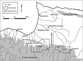
Given the scarcity of Roman pottery published from any of the Soli excavations, it is not possible to compare directly with the ceramic data from the hinterland (mainly Ginouvès Reference Ginouvès1989, pls VI–VII; Tinh Reference Tinh1985, figs 208–21 and 229–31; Westholm Reference Westholm1937, pls 174–5, 178–9; Vessberg and Westholm Reference Vessberg and Westholm1956, fig. 33:15). However, in accordance with the system of partage, one third (as well as what could be bought from the owner of the land) of the finds collected by the Swedish Cyprus Expedition returned with the excavators to Sweden and 40 crates of finds from Soli are kept in the well-organised storerooms of the Medelhavs Museum outside Stockholm.Footnote 17 There is very little Late Roman pottery in these crates, but a base of the unmistakable Mavrovouni amphorae produced in the Troodos foothills was identified among the material from the fill above the theatre of Soli. Although consisting of only one fragment, the selected material is representative, and it is important because this type of amphora has a very restricted distribution in the hinterland of the Morphou Bay. Apart from Soli, it has only been recorded within the TAESP area, where it was first identified, and just to the east around the slag heap in the Peristerona Valley, at the cooking ware factory at Dhiorios, and possibly at the sanctuary of Aphrodite near Morphou exclusively connecting this area (Fig. 10).Footnote 18 Visual connections between sanctuaries in the hinterland of the Morphou Bay, Soli and the Karkotis Valley also suggest a significant connectivity within this territory already during the Iron Age, when the placement of sanctuaries may have ideologically protected Solis’ access to the mineral resources (Papantoniou and Bourogiannis Reference Papantoniou and Bourogiannis2018, 14). In the Roman period, the obvious gateway community to tie together the network in the Skouriotissa hinterland should indeed be Soli (Fig. 11). As the analysis has indicated, Soli provides all the archaeological evidence for a successful Roman city in Cyprus, combining imperial trends such as the construction of theatres, fountains, and colonnaded streets as well as the use of marble with local preferences (most specifically identifiable in the Cholades sanctuary and the circulation of local amphora types). This may be viewed as the material expression of the local elite's development of ‘a historically-contingent insular yet strategically cosmopolitan cultural identity’ (Gordon Reference Gordon and Kouremenos2018, 33). The evidence for the Late Roman city is much more elusive, but appears to concur with stronger evidence from Salamis, Paphos and Amathous concerning the focal location of the basilica (Kyriakou Reference Kyriakou, Papanotniou, Morris and Vionis2019, 54).
Map of the northern Troodos and the Morphou Plain (map by M. Given; copyright TAESP).

Network of chronotypes hypothesising the role of Soli.

THE SKOURIOTISSA HINTERLAND AND CYPRUS BEYOND
The eastern part of the TAESP network appears to represent a rather well-preserved, small mining centre with an agricultural support system, whereas the western part is more difficult to interpret even if the low diversity of chronotypes does not support the presence of a ceramic redistribution centre in the Karkotis Valley. The north-western part is clearly also a mining centre, but the connection to an agricultural support system is more tenuous. The evidence for mining at Skouriotissa is abundant and diverse, but the site is greatly disturbed. As mentioned above, Noller (Reference Noller2013b, 311) associated the large-scale land sculpting by agricultural terracing with Roman-era mining, but there is also some evidence in the form of imported transport amphorae to suggest that Skouriotissa was possibly partly fed from the outside world.
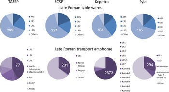
Although Late Roman Amphorae Type 1 occurs at nine out of twelve sites, transport amphorae are rare in the TAESP landscape. Imported Late Roman table wares on the other hand are common and widely distributed even deep into the mountains, as we have seen at Trimitheri (Table 2). LRD form 9 occurs at ten out of twelve sites; LRD form 2 at seven out of twelve sites; the third-most well-represented table ware form is LRC form 10, which occurs at five out of twelve sites. One way to evaluate the significance of this pattern of numerous imported table wares and few imported transport amphorae/food stuffs is to compare the TAESP data with that from comparable surveys such as the Sydney Cyprus Survey Project (SCSP). SCSP was an earlier, systematic intensive archaeological survey in the copper-producing landscape around Mitsero west of ancient Tamassus in the 1990s, in effect the progenitor of TAESP (Given and Knapp Reference Given and Knapp2003).
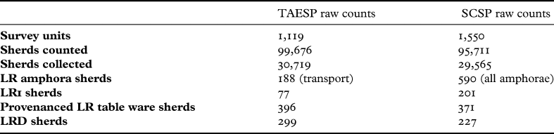
In order to compare TAESP data with the SCSP data, a few words on the pottery strategies are necessary. Although the strategies for the registration of the pottery collected were different, TAESP and SCSP largely applied the same methodology for collecting (Given et al. Reference Given, Noller, McCartney and Winther-Jacobsen2013d, 20; Given, Meyer and Whitehill Reference Given, Meyer and Whitehill2003). SCSP ran longer and surveyed 28 per cent more survey units than TAESP (Table 6). However, TAESP collected 4 per cent more pottery. The collection strategy was shared by the two projects, aiming at a representative sample, and both have collected 31 per cent of the pottery counted. The higher number of sherds counted in fewer survey units would seem to suggest that a higher number of sherds were preserved on the surface in the TAESP area. However, learning from the experience of SCSP, the people working on TAESP were possibly better trained and worked more slowly, and thus were probably more observant.
Comparison of TAESP and SCSP raw numbers (available online <http://archaeologydataservice.ac.uk/archives/view/taesp_ahrc_2007/> accessed March 2020).

There are no available quantified/-able regional datasets from southern Cyprus, but two site surveys have published quantified datasets: the site survey of the Late Roman village and monastery Kalavasos-Kopetra (Rautman Reference Rautman2003) and the site survey of the coastal town of Pyla-Koutsopetria (PKAP; Caraher, Moore and Pettegrew Reference Caraher, Moore and Pettegrew2014). Kopetra is located in the Vasilikos Valley 4 km from the sea and 7 km from the Kalavasos mining area. Although the data comes from a single period site survey rather than a diachronic regional study, the association between Kopetra and the Kalavasos mines makes it an interesting case study. Pyla is located 10 km east of Citium and is believed to be a prosperous Late Roman emporium of approximately 40 ha with access to the presumed coastal roadway and a shallow harbour (Caraher Reference Caraher2014, 291–5).
In all four surveys, the predominant table ware represented by 53 to 60 per cent of the sample is consistently LRD from western Cyprus and Pisidia (Fig. 12). No kilns have been found in Cyprus, and the identification of the production of LRD around Paphos in south-western Cyprus is based on its distribution pattern and chemical characteristics (Rautman et al. Reference Rautman, Gomez, Neff and Glascock1993; Meyza Reference Meyza, Daszkiewicz, Raabe, Meyza and Młynarczyk1995, n. 2). Recently, a number of workshops have been identified in the hinterland of Perge on the south coast of Asia Minor (Jackson et al. Reference Jackson, Zelle, Vandeput and Köse2012), which rather changes the geographical focus for the sites on the north side of the Troodos Mountains. Instead of sailing around the Akamas to connect with Paphos, the table wares could be obtained from across the water where there were several cities along the coast. When we get to the second-most-common table ware there is a little more fluctuation. LRC ranges between 16 per cent (SCSP and Pyla) and 25 per cent (Kopetra) of the total sample. In the Skouriotissa hinterland, there is some competition from the LRC from Western Asia Minor especially during the late fifth and early sixth centuries. The chronology of imports appears to peak in the late sixth to early seventh centuries AD in the SCSP area as well as at Kopetra and at Pyla (Moore Reference Moore2003, fig. 6:4; Rautman Reference Rautman, Stewart, Davis and Weyl Carr2014, fig. 4:13; Caraher and Pettegrew Reference Caraher and Pettegrew2014, 233), although smaller sites in the upper Vasilikos Valley appear to have peaked earlier (Rautman Reference Rautman, Stewart, Davis and Weyl Carr2014, fig. 4:6–7). In the TAESP area this is difficult to estimate since more than half of the sherds are body sherds, and they cannot be assigned a firm date (Fig. 13). However, as mentioned above, the distribution of diagnostic Late Roman table ware forms suggests an earlier peak. The most common Late Roman table ware is LRD form 2, and the most common imported Late Roman table ware is LRC form 3, which creates the earlier peak probably in the mid-sixth century. In comparison at Pyla, the most common Late Roman table ware is LRD form 9, and the most common imported Late Roman table ware is LRC form 10. Furthermore, LRD form 9, which is the second most common Late Roman table ware form in the TAESP area, is now dated from the mid-fourth to the mid-eighth centuries (Armstrong Reference Armstrong and Mango2009). The earlier peak also occurs in the Canadian Palaepaphos Survey Project (CPSP) working a large territory east of Paphos and on the Akamas (Moore Reference Moore2003, 281, fig. 6:4; Fejfer Reference Fejfer1995, 22–4, 58–62; Lund Reference Lund, Wriedt Sørensen and Rupp1993, fig. 54:1–2). Scott Moore (Reference Moore2003, 281–2) considered the proportion of ARS in the SCSP area an anomaly, and with 18 per cent, there is a small overweight. For comparison, ARS makes up 13 per cent of the Late Roman table wares of the surface finds at Kopetra and 9 per cent at Pyla (Fig. 12), as well as 10 per cent of the published Late Roman table wares from CPSP. LRD table wares also dominate other sites on the south coast of Cyprus, but the proportions of LRC and ARS seem much more heterogeneous at the supra-regional Cypriot level (Bes Reference Bes2015, fig. 105).
Comparison of occurrence of table wares and transport amphorae in the TAESP and SCSP landscapes and the site surveys at Kopetra and Pyla. The SCSP and the Pyla raw counts included all sherds classified as amphorae, not only transport amphorae. For TAESP and SCSP, see <http://archaeologydataservice.ac.uk/archives/view/taesp_ahrc_2007/> accessed April 2021. For Kopetra see Rautman Reference Rautman2003, table 2:2. For Pyla see Caraher and Pettegrew Reference Caraher and Pettegrew2014, table 5:29.

Occurrence of Late Roman table wares in the TAESP area.

The distribution of transport amphorae across the four data sets is much more diverse. In the TAESP area, the largest variety of types is associated with Skouriotissa, but the distribution of transport amphorae in the TAESP area is sparse, suggesting in general very few imports of foodstuffs. The SCSP and PKAP records read differently, since all amphora sherds were grouped together regardless of their function (table, storage or trade). Consequently, there was no specific category for transport amphorae as opposed to other types of amphorae (Given and Knapp Reference Given and Knapp2003, 327; Caraher and Pettegrew Reference Caraher and Pettegrew2014, 178–81). With TAESP, very narrow criteria were applied to the identification of transport amphorae: only fragments recognisable by form and/or imported fabric. Rim or handle fragments of local fabrics that may have come from utility amphorae were not assigned to this group. On the other hand, more than 200 per cent more LR1 amphorae were collected in the SCSP area, which might indicate that although the number of sherds preserved on the surface may have been slightly higher in the TAESP area, the overall number of transport amphorae appears to be even lower. Of course, the TAESP landscape is a rural area and no large-scale settlements of the Late Roman period have been identified. Ancient cities are associated with the consumption of foodstuffs, and since the ancient city of Tamassus is located just west of the SCSP area, this may account for the higher number of transport amphorae collected there. The status of Tamassus is poorly documented during the Roman period (Buchholz Reference Buchholz1973, 381–7; Mitford Reference Mitford1980, 1331–2), but the results of SCSP suggested it was a market town, a second-rank settlement (Moore Reference Moore2003, 282).
The most common Late Roman amphora type in all of Cyprus, the LR1 type, may have come from production sites known from waste dumps on the south coast of Cyprus (Demesticha Reference Demesticha2000; Reference Demesticha and Bakirtzis2003; Demesticha and Michaelides Reference Demesticha, Michaelides, Villeneuve and Watson2001), but of course the type was also produced at coastal sites in Cilicia and possibly on the northern-most Levantine coast (Empereur and Picon Reference Empereur and Picon1989; Piéri Reference Piéri2005, 69–85; Reynolds Reference Reynolds, Gurt i Esparraguere, Buxeda I Garrigós and Cau Ontiveros2005, 566). Even with the 200 per cent increase in LR1 amphorae in the SCSP landscape the type still makes up only 0.7 per cent of the entire dataset, which seems a very low number, but difficult to break down without a reference. At Kopetra LR1 amphorae make up 20 per cent of all the ceramics collected in the site survey by count; together with the tiles they make up 60 per cent (Rautman Reference Rautman2003, 27 and table 2:2). Although sherds from different periods were collected in the survey, Kopetra is considered a single-phase Late Roman site, so the sample does not have the diachronic aspect of the TAESP and SCSP samples. In addition to the abundance of LR1 amphorae, a full complement of the standard, Eastern Mediterranean, Late Roman package of transport amphorae is represented at Kopetra (Fig. 12; Rautman Reference Rautman2000, 321). This wide range of Late Roman transport amphorae also separates the TAESP and SCSP areas from sites such as Kopetra and Paphos on the south coast of Cyprus (Winther Jacobsen Reference Winther Jacobsen, Eiring and Lund2004, 146; Rautman Reference Rautman2003, 211–12, table 2:2). However, it is interesting that the emporium Pyla cannot compete with the wide range of transport amphorae at Kopetra either. At Pyla LR1 dominate, with an ‘overwhelming number’ scattered across the surface, but LR2 are the second most common transport amphora type and very few Palestinian amphorae were recorded (Caraher Reference Caraher2014, 291). This is not dissimilar to the finds from the rural site of Panayia Ematousa in the hinterland of Citium, where LR1, LR2, LR5 and Egyptian amphorae have been recorded, but no LR4 (Winther Jacobsen Reference Winther Jacobsen, Eiring and Lund2004, 144; Reference Winther Jacobsen, Wriedt Sørensen and Winther Jacobsen2006, 315).
The presence of tiles from Paphos at Kopetra indicates a special relationship between these two sites, possibly between Paphos and the Kalavasos mining area, although there is also evidence for Late Roman copper extraction in the pillow lavas above Palaepaphos (Fox, Zacharias and Franklin Reference Fox, Zacharias, Franklin and Rupp1987, 175). Consequently, the difference may be a question of hierarchy of consumption. Finds from CPSP east of Paphos appear to include the predominant LR1 as well as rare LR4 and LR5 amphorae (Lund Reference Lund, Wriedt Sørensen and Rupp1993, 130–5).
The distribution of the three major imported table wares is remarkably similar, although no single site in the TAESP or SCSP areas can boast the range of forms recorded at Kopetra and Pyla. Additionally, the TAESP and SCSP projects both collected a more restricted range of Late Roman transport amphorae, but also a significantly lower number compared to Kopetra. This difference cannot be explained away by the difference between regional and site surveys. From the entire survey areas, TAESP collected 5 per cent and SCSP 15 per cent of the number of the transport amphorae sherds in comparison to the single site survey at Kopetra! Although numbers are much lower at Pyla compared to Kopetra, PKAP still recorded more transport amphora sherds in one site survey than the two regional surveys did individually. It seems to be a clear case of the hinterland factor.
The two most common table wares and transport amphora types in Late Roman Cyprus, the LRD and the LR1, were produced both in and outside of Cyprus, and until the different productions can be distinguished with confidence their regional circulation pattern is difficult to understand. If we mean to study regional circulation patterns, we must turn to regional types. Comparing distribution patterns of utility and cooking wares is more difficult, since these types are generally less standardised, although there are examples contradicting this pattern, e.g. the products from the Late Roman cooking ware factory at Dhiorios, which were recorded in all four data sets.Footnote 19 The Late Roman cooking ware factory at Dhiorios is located on the Morphou Plain north-west of Soli in the middle of an area with many small Late Antique settlements (Catling Reference Catling1972). With no identified harbours or cities in the close proximity, it seems an unlikely location if the production was targeting overseas consumers, but the Roman cooking ware production is highly specialised (Armstrong Reference Armstrong and Mango2009, 158), and although settlement is dispersed in this area it also appears intense. Products from Dhiorios also occur in western Cyprus, e.g. in the seventh-century fill of the South Basilica at Arsinoe (Caraher, Moore and Papalexandrou Reference Caraher, Moore and Papalexandrou2019, 358–9), but Dhiorios products were ‘traded all around the Mediterranean’ (Armstrong Reference Armstrong and Mango2009, 165–7).
Kopetra shares several types of utility ceramics, but few examples have been illustrated in the SCSP and PKAP volumes. Some shared trends can be observed on utility ceramics such as piecrust decoration, but these are much more widely diffused trends and do not signify any particular relations between these two areas specifically. Utility ware typologies are not generally as robust as table ware and transport amphora typologies, signifying a less centralised production system. It may also reflect less need for standardisation in this category of vessels, which was not expected to be exported. The few Late Roman utility types which occur more than once in the TAESP area and for which close parallels have been identified at other sites including Dhiorios and Kopetra are all heavy utility basins, e.g. HUR01 (Winther-Jacobsen et al. Reference Winther-Jacobsen, Gabrieli, Horowitz, Janes, Sollars and Vroom2013a, 105, nos 153–4, 153, no. 468, 177, no. 629; Bonifay Reference Bonifay2004, 267, no. 2 (Commune type 31), fig. 148; Catling Reference Catling1972, 57, no. P244, fig. 33, 69, no. P581, fig. 38; Rautman Reference Rautman2003, 191, no. 98, fig. 5:8) and HUR24 (Winther-Jacobsen et al. Reference Winther-Jacobsen, Gabrieli, Horowitz, Janes, Sollars and Vroom2013a, 147, no. 423, 151 nos 459 and 462; Catling Reference Catling1972, 33, no. P229, fig. 20, 67, no. 220A, fig. 38, 70, nos P289 and P442, fig. 37; Rautman Reference Rautman2003, 191, no. 100, fig. 5:8) (Fig. 14). HUR01, the piecrust basin, which is a development of a common Roman type of basin, has also been recorded by SCSP and PKAP.Footnote 20 Thirteen fragments of the very distinctive HUR08 basin only produced one single parallel from the unpublished but well-dated Late Antique dump at Agios Kononas in the Akamas (Fig. 14).Footnote 21 Interestingly, basins seem to be the occasional exception from the low degree of standardisation rule, as indicated by the diffusion and emulation of the so-called Persian bowls during the Late Geometric–Archaic periods (e.g. Spataro and Villing Reference Spataro and Villing2009).
HUR01 (TCP154), HUR24 (TCP423), and HUR08 (TCP266) (copyright TAESP).

One of the types explored in the study of regional circulation by Lund (Reference Lund2015, 138–40) is a cooking ware type, the frying pan with wishbone handles, which is associated with western Cyprus but also occurs in the zone of north-western Cyprus. Although the number of recorded frying pans with wishbone handles continues to increase in north-western Cyprus,Footnote 22 there is further evidence for the differentiation of the zone of north-western Cyprus. Both the earlier and the later local Roman amphora types AmSk and Mav appear to have a restricted distribution within the hinterland of the Morphou Bay and the Cape Krommyon Peninsula, which was densely settled during late antiquity even if the latter appears to peak later than the northern Troodos foothills (Rautman Reference Rautman2003, 249; but see also Armstrong Reference Armstrong and Mango2009). On the other hand, the only comparanda for the Late Roman HUR08 basins, which occur in the TAESP area, has come from Agios Kononas in the Akamas. The evidence is not clear, and there is certainly some overlap of circulation during the Roman period.
To conclude, the distribution of imported table wares and transport amphorae suggests that the Skouriotissa hinterland was well-connected in the pursuit of ‘modest luxuries’ such as table wares, but much less so when it came to foodstuffs. Moreover, the culmination of the Late Roman expansion in the Skouriotissa hinterland appears to happen in the first half of the sixth century rather than the second half, and this may be related to the absence of second-rank settlements such as Tamassus, Pyla and Kopetra. The low level of imported foodstuffs is most probably also the product of the same absence. Although the same pattern is largely true of SCSP, the higher proportion of transport amphorae may be a product of the ‘urban’ component of this landscape associated with the ancient city of Tamassus, which continued as a market town, a second-rank settlement in the Roman period (Moore Reference Moore2003, 282). Interestingly, this absence does not appear to have the same effect on the distribution of different imported table wares, which seems remarkably consistent in all the data sets. This implies the existence of a different circulation pattern less dependent on second-rank settlements. Marcus Rautman (Reference Rautman, Stewart, Davis and Weyl Carr2014, 50) remarked on the variety of imported table wares as a demonstration of ‘a growing demand for objects of modest luxury’ in connection with the material from Kalavasos-Kopetra. Concerning the distribution of regional types, the local transport amphora type provides strong ceramic evidence for a continuation of a north-western Cyprus zone of distribution in the Late Roman period, but there is also growing evidence to suggest a close connection with western Cyprus.
THE SKOURIOTISSA HINTERLAND AND THE SOUTH-CENTRAL COASTAL AREA OF ASIA MINOR
Close connection to western Cyprus may also be explored through the associations with southern Asia Minor, just as Lund (Reference Lund1999; Reference Lund, Wriedt Sørensen and Winther Jacobsen2006; Reference Lund, Hoff and Townsend2013) has tied the Hellenistic–Early Roman pottery circulation of western Cyprus (Paphos and the Akamas) to Pisidia in southern Asia Minor (see also Autret Reference Autret and Georgiou2012). From her studies of the distribution of Early Roman amphorae produced in Rough and Flat Cilicia, Autret (Reference Autret and Georgiou2012, 263–4) recognised the existence of a close economic interdependency with Cyprus. This is seen as the Roman effect on provincial commerce and specialised agricultural productions, as demonstrated in Crete by Marangou-Lerat (Reference Marangou-Lerat1996). The landscape between Iuliosebaste and Coracesium (Alanya) was studied by the Rough Cilicia Archaeological Survey Project (Fig. 15), which has identified a diverse exploration of the landscape (e.g. Rauh and Slane Reference Rauh and Slane2000; Rauh and Will Reference Rauh and Will2002; Rauh Reference Rauh, Eiring and Lund2004). In Rough Cilicia, amphorae from several amphora production sites have been identified as types which have been identified in the Skouriotissa hinterland although not at the above-mentioned sites. These include very poorly preserved handle fragments of an Early Roman, bell shaped, pseudo-Koan amphora (TCP491) and a Middle Roman pinched-handle amphora as mentioned above (TCP228) (Autret Reference Autret and Georgiou2012, 255–7). None of these fragments, however, contained mica, which has been suggested at least for the pinched-handle amphorae as a way to distinguish the Cilician from the Cypriot production (Hayes Reference Hayes1991, 91; Lund Reference Lund, Ioannides and Chatzistylli2000). Although the period of prosperity in Soli coincides with that of the cities in the south-central costal area of Asia Minor, only one fragment of the otherwise ubiquitous second–third-century amphorae with pinched handles has been recorded in the TAESP area (and none in the SCSP areas), which speaks against a specific regional connection between the north-western Cyprus zone and southern Asia Minor, but what about the Late Roman period? It has long been recognised that LR1 amphorae were produced in Cyprus as well as at coastal sites in Cilicia. The recent identification of LRD production sites in the hinterland of Perge supports a strong connection between south-western Cyprus and Pisidia during the Late Roman period.Footnote 23 According to the traditional dating, the majority of the material recovered in Pisidia belongs to the fifth to seventh centuries (Jackson et al. Reference Jackson, Zelle, Vandeput and Köse2012, 109). It is tempting to interpret the Pisidian production as Cypriot workshop owners moving on to a more prosperous/well-connected area possibly after the devastating earthquakes of the fourth century, which also moved the capital from Paphos to Salamis.
Map of Cyprus and the south coast of Asia Minor (map by M. Given; copyright TAESP).

The regional correlation between the locations of the LRD table ware and LR1 amphora production centres suggest a strong connection in general between Cyprus, Pisidia and Cilicia; however, they do not appear to be linked by contemporary administrative structures in the Late Roman period: the recently discovered LRD production centre is located on the wrong side of the border of the Diocesis Oriens, which seems to be the area of its consumption as indicated by the current distribution map (Meyza Reference Meyza2007, map 2; Pacetti Reference Pacetti, Quilici and Quilici Gigli1995, fig. 1). In fact, in 563 Justinian created a new administrative unit, the Quaestura Exercitus, associated by Olga Karagiorgou (Reference Karagiorgou, Kingsley and Decker2001, 154) with the annona militaris, the supplies for the legions in this case drawing upon the Black Sea area. This administrative organisation separated Cyprus from the south coast of Asia Minor (Novellae Constitiones 41).
It is not currently possible to demonstrate a specific regional connection between north-western Cyprus and Pisidia on the basis of the occurrence of LRD table ware since none of the fragments published from the kilns in the hinterland of Perge bear a very close morphological or decorative resemblance to the fragments from the TAESP survey. However, the wide distribution of LRD table wares in the TAESP landscape suggests that Paphos and/or the cities on the central-south coast of Asia Minor were the primary ports of call before Soli. Unfortunately, there are no quantified/-able Roman pottery datasets in this part of Asia Minor, but a detailed study of the Late Roman pottery has been published from Anemurium and to some extent from the small thermae at Perge (Fig. 15) (Williams Reference Williams1989; Atik Reference Atik1995). If we compare the qualitative distributions of transport amphorae at the two available sites, the restricted occurrence of the members of the standard, Eastern Mediterranean, Late Roman amphora package in the TAESP and SCSP areas also applies to Anemurium and possibly Perge (Williams Reference Williams1989, 90–1; Atik Reference Atik1995, 199–200). Of the imported amphorae, the study collection suggests that the Rough Cilicia project collected mostly LR1 fragments.Footnote 24
Concerning the distribution of the Late Roman table wares, there also seem to be some general similarities at Anemurium. Here LRD outnumbers LRC and ARS approximately 2:1 (Williams Reference Williams1989, 27–8). In the TAESP and SCSP areas, the dominance of LRD is more pronounced. ARS already occurs in the Middle Roman period, but often the surface finds cannot be dated precisely, and consequently this group may be overrepresented in the Late Roman period. The Rough Cilicia Archaeological Survey Project study collection suggests that the project collected much more LRD than LRC and ARS respectively.Footnote 25
Cooking wares from Dhiorios also occur at Anemurium,Footnote 26 but although many large basins from Anemurium have been published, none of the three TAESP types occur (Williams Reference Williams1989, 76–82, figs 42–7). The material from the Rough Cilicia project study collection offers no parallels to the cooking and utility wares from the TAESP hinterland, nor any fragments of Mavrovouni amphorae.Footnote 27
The most abundant archaeological evidence from the TAESP hinterland is pottery, but datasets for a close comparison are not readily available on the southern coast of Asia Minor. However, the same types of pottery were produced in Cyprus as on the southern coast of Asia Minor, Cypriot cooking wares were imported to sites on the south coast of Asia Minor, and the same types of imports circulated, although it is not possible to explore the proportions of the different types. When it comes to the Late Roman amphorae, the TAESP area shares with Anemurium the dominance of the LR1 amphorae with very few LR4 and LR5 occurring; however since one is a hinterland and the other a coastal town, the significance is difficult to estimate. SCSP, CPSP, PKAP and Panayia Ematousa all appear to follow the pattern of a restricted range of food import greatly differentiated from consumer sites such as Paphos, but more surprisingly from small rural Kopetra. Consequently, it appears that the close connection between Cyprus and southern Asia Minor is a general phenomenon, rather than a regional one.
CONCLUSIONS
The first aim of this article was to analyse the dynamics of the settlement pattern of the Late Roman TAESP landscape and its relationship to the nearest city, Soli. The Late Roman period is the era with the most widely diffused settlement pattern in the Skouriotissa hinterland with settlement activity deep inside the Troodos Mountains. All the Late Roman sites identified appear to be associated with either mineral or agricultural production, and sites associated with ‘luxury’ consumption could not be identified: there was not a single tessera, no marble,Footnote 28 no baths, no villas. There is positive evidence for extra-urban luxury in the north-western zone of Cyprus; 17 km west of Soli at the coastal site of Mansoura the remains of an early fifth-century mosaic floor found in the early twentieth century were interpreted as a villa bath (Michaelides Reference Michaelides1993), but there is no further information available about this site. Consequently, although there were luxurious rural residences in the region, there is currently no evidence of luxury consumption in the hinterland to suggest that wealth was widely distributed among those who toiled on the land and at the mines.
Although several of the sites are closely connected, none of them scores high on the centrality scale in terms of multi-function. The network is missing a ceramic production and redistribution centre, and there is no evidence for administration, security or cult. Indeed, the settlement system of the Skouriotissa hinterland fails to produce a convincing second-rank settlement. However, the TAESP area possessed rich mineral and agricultural resources, and large-scale mining in the Roman period would have put an enormous drain on the agricultural resources and labour as well as providing the motivation for strong external control. A combination of written, epigraphical, and archaeological sources as well as geography suggests that the settlement system in the Skouriotissa hinterland was closely integrated with the coastal city of Soli and through that city to a remote administrative centre of organisation, since the mines were owned most probably by the emperor (Kassianidou Reference Kassianidou, Ioannidis and Hadjistyllis2000). Lund (Reference Lund2020b) has recently suggested that the loss of control of the copper mines meant a decline in direct Cypriot involvement in overseas trade in the Hellenistic and Roman periods. However, as the analysis has indicated, Soli provides all the archaeological evidence for a successful Cypro-Roman city combining imperial trends with local preferences enabling a material expression of the local elite's development of ‘a historically-contingent insular yet strategically cosmopolitan cultural identity’ (Gordon Reference Gordon and Kouremenos2018, 33). The evidence for the Late Roman city is much more elusive, but appears to concur with stronger evidence from Salamis, Paphos and Amathous concerning the focal location of the basilica (Kyriakou Reference Kyriakou, Papanotniou, Morris and Vionis2019, 54).
The second aim was to analyse and contextualise the Late Roman TAESP landscape materially and economically in relation to the copper-producing landscapes of Cyprus to the east and south, and supra-regionally in relation to the cities on the south coast of Asia Minor. The distribution of imported table wares and transport amphorae suggests that the Skouriotissa hinterland was well-connected in the pursuit of ‘modest luxuries’ such as table wares, but much less so when it came to foodstuffs. The latter may be related to the apparent absence of second-rank settlements such as Tamassus, Pyla and Kopetra, as well as possibly Pano and Kato Katalymata and Katalymata ton Plakoton on Akrotiri (Procopiou Reference Procopiou, Stewart, Davis and Weyl Carr2014; Sollars Reference Sollars2005; Rautman Reference Rautman, Stewart, Davis and Weyl Carr2014, 41). This phenomenon does not appear to have had the same effect on the distribution of different imported table wares, which implies the existence of a different circulation pattern less dependent on second-rank settlements. The culmination of the Late Roman expansion in the Skouriotissa hinterland appears to happen in the first half of the sixth century, contemporary with datasets from CPSP and the Akamas area rather than the second half when Pyla and Kopetra as well as the SCSP dataset culminate. This suggests that the chronology is significant to the development of successful second-rank settlements, which do not appear in the areas with the early culmination. The extraordinary site of Peyia-Agios Georgios, with its three basilicas and a bath complex, is located in the southern end of the Akamas, but the site appears to be entirely oriented towards the sea (Bakirtzis Reference Bakirtzis, Karageorghis and Michaelides1995; Reference Bakirtzis, Karageorghis and Michaelides1996; Rautman Reference Rautman, Stewart, Davis and Weyl Carr2014, 41). Of course, the small anchorage at Kioni could have been the harbour to connect settlements in the Akamas with Peyia (Leonard Reference Leonard1995b).
The third aim was to analyse and contextualise the Late Roman TAESP landscape chronologically in relation to the Early Roman ceramic zones defined by Lund. Concerning the distribution of regional types, the local transport amphora type provides strong ceramic evidence for a continuation of a north-western Cyprus zone of distribution in the Late Roman period, but there is also growing evidence to suggest a close connection with western Cyprus. Apart from western Cyprus, there is little evidence that the TAESP hinterland enjoyed specific regional connections with other parts of Cyprus, although the circulation of imports demonstrates a large degree of homogeneity in external connections. This also applies to Asia Minor where it seems that the close connection between Cyprus and southern Asia Minor is part of the general Roman imperial system, rather than a more closely defined regional network.
The density of population and richly ornamented churches give evidence to the unprecedented prosperity enjoyed by Cyprus in the sixth and first half of the seventh centuries (Papageorghiou Reference Papageorghiou, Bryer and Georghallides1993, 34). According to Rautman (Reference Rautman, Stewart, Davis and Weyl Carr2014, 41), Late Antique Cyprus was characterised by a prosperous string of cities and secondary towns, which constituted the maritime façade of a rich and varied landscape that had supported local economies for centuries. For political, military and economic reasons the unified state offered the urbanised coastal centres unlimited access to inland resources during the Hellenistic and Early Roman periods (Vionis and Papantoniou Reference Vionis, Papantoniou, Cau Ontivero and Mas Florit2019, 261). This allowed the Cypriot cities to develop their own monumental style under the influence of their foreign masters (Rautman Reference Rautman and Callaway2001; Fejfer Reference Fejfer, Wriedt Sørensen and Winther Jacobsen2006; Gordon Reference Gordon and Kouremenos2018). The majority of cities such as Soli continued to be settled from the Iron Age through the Hellenistic and Roman Imperial periods into the Late Roman period. During the Late Roman period, the active Christianising of the countryside in the fifth and sixth centuries suggests that this urban monopoly was broken (Kyriakou Reference Kyriakou, Papanotniou, Morris and Vionis2019). Sixty rural churches of this period have been recorded, but with a rural population conservatively calculated at 125,000 a figure of approximately 500 rural churches is to be expected (Rautman Reference Rautman, Stewart, Davis and Weyl Carr2014, 43). Evidence for the Christianisation of the countryside is, however, poor in the copper-producing landscapes on the north-western side of the Troodos Mountains, with Early Christian basilicas seemingly an urban (Soli) or pseudo-urban (Politiko-Agios Ierakleidos in the vicinity of Tamassus) phenomenon. Even if archaeological surveys struggle to distinguish villages, monasteries, and rural churches in the surface record, it seems significant that two different projects have produced this result. During the Roman period, Cyprus produced no civic coins and hosted only one mint issuing provincial coinage up until the first third of the third century (Parks Reference Parks2004, 137). However, briefly Emperor Heraclius established a mint in Cyprus in 609/10, and Papacostas (Reference Papacostas, Kingsley and Decker2001, 111 and n. 37) has suggested that the local metal resources may have been what attracted the Emperor to the island. One possible explanation for the lack of evidence for the development of villages into administrative and market centres of second-rank rank in the Skouriotissa hinterland is that the presence of the great copper mines provided the continued need for unlimited access to inland resources preventing the development of second-rank settlements. Drawing upon a critical evaluation of complex source material Neil Urwin (Reference Urwin2013, 320, fig. 4:11) has calculated that the build-up of the slag heap at Skouriotissa reflects a daily need for 18 tons of charcoal from an area of 516 m2 within the lower slopes of the Troodos Mountains, which would have required 200 daily donkey trips per day. These calculations demonstrate well the need for unlimited access to inland resources associated with the mining of Skouriotissa.
The introduction of small-scale operations has been suggested as an explanation for reorganisation of mineral and lithic exploitation during the Late Antique period (Edmondson Reference Edmondson1989), and possibly this is what we find at Mavrovouni, where smelting certainly took place in the fifth and early sixth centuries (Graham et al. Reference Graham, Banks, Digney, Evans, Gabrieli, Given, Hadjianastasis, Kassianidou, Lufafa, McCartney, Ntinou, Urwin, Vroom and Winther-Jacobsen2013, 180). This local pattern seems to contradict the pattern of centralised monopoly, and the area is located deep into the zone of hypothesised charcoal production for Skouriotissa. Possibly what we find is a combination of small-scale and large-scale operations, since the Late Roman date of the enormous slag heap at Skouriotissa, which makes up half of all the slag in Cyprus, in itself provides the strongest evidence to support a continuing need for a centralised administration. The rebuilding of the basilica after the Arab raid and the continuation of the Roman settlements in Cape Kormakiti into the eighth century demonstrates that the Arab raids did not completely disrupt settlement in north-western Cyprus. The recent adjustments of the chronology of the late Late Roman D forms such as form 9, which is one of the most common LRD forms across the TAESP landscape and which exhibits great variability, suggest that life continued in the hinterland in the second half of the seventh and eighth centuries as well. As Rautman (Reference Rautman2003, 259–62) has suggested it was not the raids, but the collapse of the economic structures which brought about a ‘dislocation of Late Roman lifeways’. The absence of Constantinopolitan glazed white ware, globular amphorae and lead glazed cooking wares of the eighth and ninth centuries in the rural hinterland is expected (Rautman Reference Rautman, Stewart, Davis and Weyl Carr2014, 52–3), but no seventh–ninth-century handmade cooking vessels have been identified either (Gabrieli Reference Gabrieli2013). This is, however, a type of pottery that has so far been the subject of little dedicated research (Rautman Reference Rautman1998; Gabrieli, Jackson and Kaldeli Reference Gabrieli, Jackson, Kaldeli, Bonifay and Treglia2007; Gabrieli Reference Gabrieli, Gabrieli, Winther-Jacobsen and Lund2020), and very possibly a revisitation of TAESP contexts would provide new information on the transition to the Early Medieval period.
ACKNOWLEDGEMENTS
I wish to express my gratitude to the TAESP project directors Michael Given, Bernard Knapp, Jay Noller and Lina Kassianidou for the invitation to join the project and direct the pottery studies and to all the participants over the years, especially Angus Graham, Alexis Boutin, Annie Evans, Erin Gibson, Smadar Gabrieli, Paul Pelosi, Luke Sollars, and Neil Unwin. ‘Thank you’ also to Michael Given and Luke Sollars for producing the maps, to Antonia Pilarinou and Giorgos Giannakopoulos for translating the abstract and to the reviewers for their support in unwinding this narrative.