




The study of Byzantium in the regions of historic Palestine and the Transjordan is intimately bound to the development of Biblical Archaeology as a discipline and set of methodological practices. As North American and European explorers throughout the nineteenth century enthusiastically embraced the identification and excavation of sites linked to the Bible, their encounters with the region’s early Christian past, represented by the excavation and survey of its network of late Roman (termed ‘Byzantine’) churches, were inexorably interwoven with the efforts of institutions such as the Palestine Exploration Fund and the École Biblique to experience and recover the lost landscapes of biblical history.Footnote 1
The two disciplines, as a result, share a common history. In cities such as Jerusalem, the literary legacies of late Roman patristic writing and pilgrimage accounts of the ‘holy land’ frequently provided archaeologists with a key corpus of sources which could be utilised in the identification and dating of biblical sites. Accounts of ancient holy land pilgrimages such as the anonymous Itinerarium Egeriae (dated c. 380) and the Itinerarium Antonini Placentini (dated 560), were thus enthusiastically mined by archaeologists and historians for the topographic information they were believed to provide about the location of biblical sites, and their condition in the centuries following the death of Christ. Even the most cursory analyses of the histories of excavation in Jerusalem by the Palestine Exploration Fund in Silwan by Archibald Dickie; at Sion by Charles Watson; and in Bethesda by John Dalton, are sufficient to demonstrate the reliance of these early archaeologists and historians on the textual testimonies of early Christian writers.Footnote 2
The ambitions of early biblical archaeologists were aided by the growing availability of early Christian works in printed editions and translation by the later nineteenth century. In English, these emerged principally through the efforts of the Palestine Pilgrims’ Text Society (PPTS). The PPTS was founded in 1884 as a close partner of the Palestine Exploration Fund, with the view of making such writings in Arabic, Greek and Latin more accessible to anglophone audiences, and of harnessing their topographical information for the benefit of biblical studies.Footnote 3 Christian writings of the fourth–seventh centuries thus came to be seen a vital link in the chain bridging nineteenth-century modernity to the distant biblical past.Footnote 4
Byzantine Studies has proven somewhat slow to recognise the discipline’s intellectual connection to Biblical Archaeology and more recent critiques of its methodologies which have emerged since the 1960s, spurred by the twin developments of Post-Processual Archaeology and Postcolonial Theory. Partly, this continues to reflect the Aegean-Anatolian focus of Byzantine Studies as a broader discipline, and its attendant streams of historiography, which have often emerged at the expense of recognising the more diverse reception of the empire’s memory in the Levant and North Africa.Footnote 5 Byzantium, when examined in the context of Greece’s history as a nation-state, is thus invariably relegated to the position of historiographical victim: overshadowed by the more positive reception of the ‘classical’ past in the western European imagination.Footnote 6 Indeed, the intellectual justification for Byzantine Studies as an independent subject of study since the 1970s has emerged principally (and rightly) through systematic challenge to perceived ideas of a classical ‘golden age’.Footnote 7
While critically vital to the development of the discipline, the emphasis on restoring Byzantium’s image within the context of Aegean-Anatolian history has often, albeit unintentionally, overlooked the more complex reception of the empire in other regions of the Mediterranean, where its memory was not only more favourably received, but also closely bound to the mechanisms of European colonial rule and territorial fashioning throughout the nineteenth century. In late Ottoman and British Mandate Palestine, the more positive reception Byzantium acquired in the eyes of British commentators – often at odds with negative contemporary appraisals of the empire in other regions – served as a key tool in the de-legitimisation of Ottoman rule in the region, and European claims to be the rightful custodians of the land. It remains an important reminder that memories of the empire across western European were (and are) situational and sensitive to the needs of individual regional and political contexts.
The purpose of this article is to present a single case study from the region of historic Palestine and the Transjordan, notably the Negev/Naqab Desert, southern Israel. Through this case study, the article explores the reception of Byzantium as an historic idea in the eyes of European and North American commentators. The following article has two principal aims. One, to demonstrate the utility of applying the same critical lessons gleaned from Biblical Archaeology to recognising Byzantine Studies’ own systemic connection to European (notably British) colonialism and state building in the region from the late Ottoman period, until the ending of the British Mandate of Palestine in 1948.Footnote 8 The second aim is to provoke a more nuanced assessments of Byzantine Studies’ own relationship to systems of European colonial rule, and the more complex reception of the empire beyond its Aegean heartlands.
Rather than a marginal discipline within the broader field of Syro-Palestinian archaeology, the development of Byzantine Archaeology in Palestine throughout the nineteenth century was closely bound to wider strategies of map-making, border definition and urban development in Palestine which were to define European interventions in the region for over a century. It is a subject which, as a result, has much to contribute to specialists of other disciplines in understanding the development and expansion of archaeological research within the region, and its relationship to systems of colonial rule.
The discussion which follows outlines the particular treatment of the Byzantine past in two principal projects: the Wilderness of Zin Survey, undertaken by Leonard Woolley and Thomas Edward Lawrence in the Negev Desert between January and February 1914, and the Colt archaeological expedition led by Harris Dunscome Colt between 1934 and 1937.Footnote 9 In particular, this study will explore the reception of the Byzantine past by both projects, and how their specific focus on agricultural terracing and water infrastructure (identified as ‘Byzantine-period’) shaped subsequent archaeological activity in the region throughout the period of Mandate rule. Those projects, and their attendant results, in turn, exercised considerable influence over archaeological investigation following the foundation of Israel in 1948, and the particular interests of the early Israeli state in agricultural management and desert greening.Footnote 10 These are intellectual legacies, as this article will show, which continue to resonate in more recent critical approaches to the desert’s Byzantine past.
Defining the Byzantine Negev
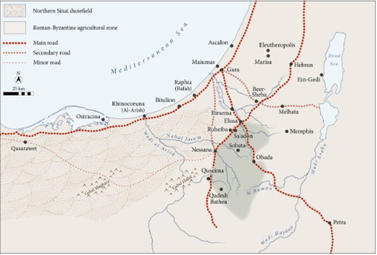
Despite its relatively marginal status within the broader superstructure of the Byzantine Empire at its sixth-century territorial extent, the Negev Desert remains one of the most extensively explored rural regions of the former Byzantine world in terms of the intensity of excavation and survey, and the volume of publication which has emerged over two centuries of historical enquiry.Footnote 11 As one of the former Byzantine Empire’s few natural deserts, it is, environmentally speaking, wholly unrepresentative of the natural conditions once encountered by the majority of its rural and urban populations. The level of interest the Negev has received – particularly regarding its past agricultural use – is largely a result of modern political concerns, shaped by the region’s changing significance in the histories of empire and statecraft since the early nineteenth century. Over the past two centuries scholarly attention has, for the most part, concentrated on the network of monumental village settlements (erroneously, but significantly, termed ‘cities’), which span the northern and central areas of the modern Negev, stretching from the former ancient settlement of Birosaba (modern Beersheba) in the north, to the southern settlement of Nessana (Auja Hafir/Nitzana), located on the current border between Egypt and Israel (Figure 1)
Map of the north and central Negev during the Byzantine period.

Figure 1 Long description
Northern Sinai, highlighting Roman-Byzantine agricultural zones and various road networks. The legend identifies main roads, secondary roads and minor roads with different dashed lines. Key locations such as Pelusium, Rhinocolura and Ostracine are marked. The Roman-Byzantine agricultural zone is shaded, while the Northern Sinai dunefield is outlined. Roads connect cities like Alexandria, Memphis and Jerusalem, with notable sites like Eleutheropolis and Hebron. The Mediterranean Sea borders the region to the north and a scale bar indicates distances in kilometers.
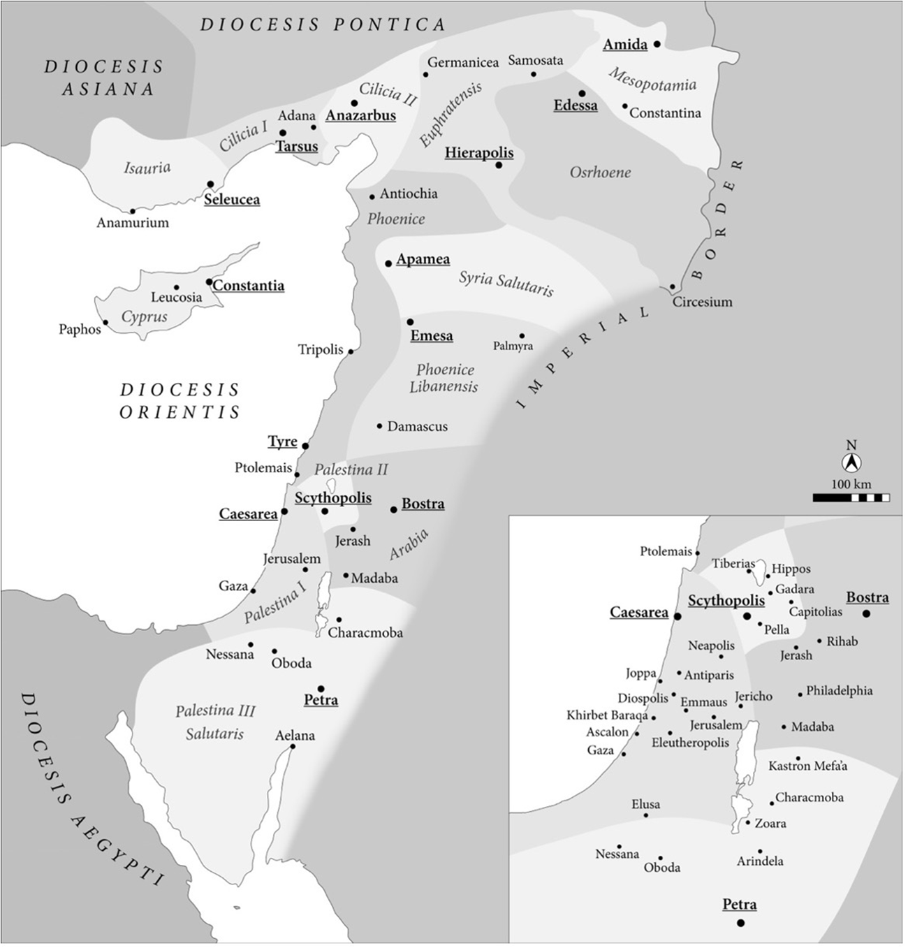
By the late Roman period, the region lay within the provincial boundaries of Palaestina Salutaris, with its metropolitan capital at Petra (now Jordan), which encompassed the Negev, the Sinai Peninsula and the Wadi Rum, in the southern Transjordan (Figure 2).Footnote 12
Map of the former Byzantine provinces of Palaestina Prima, Secunda and Salutaris, and Arabia in c. 600.

Figure 2 Long description
The eastern Roman Empire is depicted, highlighting dioceses such as Diocesis Orientis, Diocesis Pontica and Diocesis Asiana. Cities are marked with dots and labeled, including Antioch, Hierapolis and Petra. The map includes a scale bar and compass for orientation. An inset map provides a closer view of the region around Petra, showing additional cities like Bostra and Philadelphia. The map outlines the boundaries of the dioceses and the location of various cities within these regions.
As an environmental space, the Negev forms part of the western extension of the Arabian desert ecosystem; in Beersheba characterised by high levels of aridity (around 200 mm of rainfall per annum) and a mean temperature range of 14°C–25°C.Footnote 13 The popular archaeological concept of the ‘Byzantine Negev’ is thus something of a modern misnomer, born from the effects of the Taba Crisis, eventually leading to the 1906 Sinai transfer to Egyptian control, and the establishment of the Emirate of the Transjordan in 1922, which effectively annexed the Negev as a bounded territorial entity.Footnote 14 Prior to the early twentieth century, definitions of the region were comparably looser; in Arabic, the desert expanse was usually referred to by the more ambiguous term ‘an-Naqab’ (literally the mountain pass), and in earlier Byzantine sources as ‘érēmos’ (literally ‘desert’ or ‘wilderness’), neither of which appear to have corresponded to the contemporary geographical borders of the Negev Desert.Footnote 15 As has long been recognised by earlier studies, archaeologists, in their efforts to chart and survey the region, emerged as key brokers in the formalisation of the Egyptian–Ottoman border and British efforts to secure strategic control of the Suez Canal.
The historical context of the Zin Survey, 1806–1914
Western European exploration of the Negev Desert, including its ‘desert cities’, can be first traced to the activities of the Swiss explorer Ulrich Seetzen, whose visit to Auja Hafir and Subeita (Shivta) in 1807 was later documented in his accounts of his travels across Syria-Palestine and Egypt, which appeared in 1856.Footnote 16 Subsequent journeys to the region by the English explorer Frederick Henniker (1820) and the US biblical scholar Edward Robinson (1838) contributed further to European and North American awareness of the ‘Negev cities’ in the succeeding decades.Footnote 17 Consistent with their interests as Protestant theologians and scholars of the Bible, their early encounters with the Negev were framed by prevailing concerns to reconstruct and document the route of the Israelite exodus from Egypt.Footnote 18 Descriptions of the Negev desert cities and observations of their Byzantine past were accordingly brief. They were often limited to occasional references to the ruins of churches (often stripped of their Roman identity and defined as ‘Greek’), while noting that their presence alluded to the former wealth and vitality of the region, which was frequently juxtaposed against the desertified landscapes of the nineteenth-century present.
Such ideas of prosperity, encouraged by knowledge of the Bible’s descriptions of Palestine as a ‘land of milk and honey’, were to become recurrent motifs in European commentary about the Negev in later decades.Footnote 19 Nevertheless, the Negev remained relatively peripheral to the early development of archaeological research in Palestine – both biblical and Byzantine – as efforts concentrated on what were perceived as the more fruitful areas of Jerusalem and central Palestine, which bore more overt connection to biblical memory.Footnote 20 Archaeological interest in the Negev was not to experience a resurgence until the late 1860s and did so primarily due to two crucial geopolitical developments which brought the region to the attention of the British government. The first was the expansion of European colonial interventions across Asia. For Britain, this was to culminate in the establishment of crown rule in India in 1858, which served to bolster the importance of south Asian markets to its expanding industrial economy.Footnote 21 The second, related, development was the construction of the Suez Canal between 1859 and 1869, which revolutionised European commercial access to the Indian Ocean via the Red Sea trade route.Footnote 22
One effect of this broader geopolitical alignment was the renewed importance of the Negev and Sinai as strategic land corridors connecting the Mediterranean basin to the Red Sea; this was to be heightened by the British annexation of Egypt and foundation of the Khedivate in 1882, which placed the Negev at the frontier between British and Ottoman territories in the Suez corridor.Footnote 23
British concerns to monitor access to the Suez Canal were characterised by renewed endeavours to acquire further information about the Negev to meet its emerging strategic importance as a land corridor between British and Ottoman territory. An effort to survey and map the region, in accordance with the methodologies and standards of the Ordnance Survey, was undertaken in 1867 by Edward Palmer and Charles William Wilson (an officer of the Royal Engineers), as part of the Survey of Sinai Project. This was one of a series of surveys steered by the Palestine Exploration Fund (PEF), including the better-known Survey of Western Palestine (SWP) and the abandoned Eastern Survey of Palestine (ESP) led by Claude Reignier Conder.Footnote 24
Consistent with the prevailing methodologies of Biblical Archaeology, the Sinai Survey’s perception of the Negev was rooted within the intellectual framework of the biblical exodus, although it went much further than previous surveys in its attention to the Negev’s Byzantine past.Footnote 25 Palmer and Wilson’s survey of the Negev villages took place over the course of February 1870, when the survey team made a visit to the sites of Auja Hafir (described as ‘El Aujeh’) and Sbeita, and embarked upon a structural survey of the site, making note of their ruined churches and fortifications, and charting evidence for their former agricultural prosperity.Footnote 26 One innovative feature of the Sinai Survey’s approach to the Negev, however, was the emphasis it placed on the identification and mapping of agricultural terracing and water infrastructure: ‘Their gardens (which may still be seen covering the plain around the city) were fruitful and well-kept, and the hills all around were covered with orchards of apples and pomegranates, and terraces of clustering vines’.Footnote 27
Combined with Palmer’s erroneous identification of the Negev villages as ‘cities’, the Survey’s interest in mapping evidence for the region’s agricultural use became inevitably linked to ideas of an historic age of productivity, and its later decline under the governance of the Ottomans and Arab Bedouin:
To call him [a Bedouin] a ‘son of the desert’ is a misnomer; half the desert owes its existence to him, and many a fertile plain from which he has driven its useful and industrious inhabitants becomes in his hands, like the ‘South Country’ [the Negev], a parched and barren wilderness.Footnote 28
Wells of solid masonry, fields and gardens compassed round about with goodly walls, every sign of human industry, was there; but only the empty names and stony skeleton of civilisation remained, to tell of what the country once had been. There stood the ancient towns, still called by their ancient names, but not a living thing was to be seen, save when a lizard glided over the crumbling walls, or screech-owls flitted through the lonely streets.Footnote 29
In invoking the images of the Negev’s abandoned towns, emptied of its human population and inhabited by screech owls, Palmer and Wilson’s descriptions evidently drew to mind the biblical accounts of Isaiah 34 and Zephaniah 2, which describe the judgement and desolation of Edom. Histories of ‘urban’ decline within the Negev were, through this association, similarly attributed to the failings of its inhabitants.Footnote 30
It has been well established in earlier studies that the results of the PEF surveys anticipated wider interests in agricultural management and environmental greening in Palestine, which emerged in the wake of the First Aliyah and efforts by early Zionist organisations to identify land suitable for Jewish settlement. Within the Negev, those ideas were not to provoke a more interventionist response in the form of agricultural and urban development until decades later, although plans to establish a Jewish colony in the Negev were articulated as early as 1883 in the writings of Zalman David Levotin. Although briefly surveyed to ascertain its suitability for Jewish settlement in two early expeditions – one in 1903 by Hibbat Zion and another by the Palestine Office in 1910 – the Negev remained fairly marginal to the interests of Zionist groups and planned settlement until the mid-1930s.Footnote 31
By 1899, tensions between the British and Ottoman empires over the Negev frontier had nonetheless escalated sufficiently to provoke more systematic intervention by the Ottoman government in Istanbul, which embarked on a process of planned resettlement of the region, and programmes of sedenterisation and fiscal reform among the region’s Bedouin populations.Footnote 32 Although initially focused on Beersheba, by 1908 Ottoman efforts had extended to Auja Hafir itself. This was granted the status of a regional kaza and furnished with a railway station, a military garrison and hospital (the latter two buildings constructed over the Byzantine fortifications on the settlement’s tel), as part of a series of efforts to monitor the emerging frontier and uphold centralised control over its Arab-Bedouin populations.Footnote 33
The Wilderness of Zin Survey (1914)
By the spring of 1914, with the prospect of a German–Ottoman alliance threatening British access to the Suez Canal, tensions had escalated sufficiently for renewed calls for a survey to update the earlier publications of Edward Palmer and provide military intelligence of the region for the British state. Within this context, the Wilderness of Zin project was conceived, officially led by the archaeologist Leonard Woolley (then known for his work at Carchemish) and Thomas Edward Lawrence, shortly before his posting to the Arab Intelligence Bureau in Cairo.Footnote 34 While officially an archaeological survey supported by the resources of the Palestine Exploration Fund, the project’s status as a covert military operation, backed by funding and authorisation from the British War Office, has been well noted by subsequent studies of the survey.Footnote 35 Over the course of January–February 1914, Lawrence and Woolley retraced the steps of the Palmer exhibition, including a visit to the sites of Auja Hafir and Subeita, which were also explicitly labelled in the report as ‘desert cities’ or ‘desert towns’.Footnote 36 Reflecting its origins in military surveillance, the Zin Survey’s reception of Byzantium was shaped by the prevailing British interest in the region’s suitability for human habitation and defence. This may be seen in the Survey’s meticulous charting of ancient water installations, agricultural terracing and fortifications, which Woolley and Lawrence attributed to direct Byzantine imperial intervention.Footnote 37 For Woolley and Lawrence, the abandoned, ruined, landscapes of the Negev cities were to be seen as a consequence of political failure, rather than environmental change. In visual terms, developing ideas of desolation and neglect under Bedouin rule were reinforced by the photographs which accompanied the publication of the Zin results in 1914. Images of the abandoned ruins of the ‘Byzantine’ churches of Sobata and Auja Hafir, set against depopulated desert scenes, further stressed the juxtaposition between the Negev’s urbanised Byzantine past and its empty present, replicating approaches applied to the photography of other archaeological sites in the same period.Footnote 38
In advancing the theory of human causation, the results of the Zin Survey presented a direct intellectual challenge to the prevailing theories of Ellsworth Huntingdon, whose earlier work, published in Palestine and its Transformation (1911), had attributed the desert conditions of the Negev to irreversible environmental change, and argued against the possibility of replicating the level of ‘urban’ density which was understood to be characteristic of the Byzantine period.Footnote 39
They [the terraces and gardens] were manifestly intended for more intensive agriculture, for olive groves, vineyards, orchards, or vegetable gardens. Today, except for the few tiny gardens watered by the gasoline pump at Beersheba, no trace of such plants is found in the Negeb, unless it be one or two grapevines which the officials of Aujeh have nursed through the droughts. General agriculture in the Negeb is today absolutely out of the question.Footnote 40
Drawing upon the estimations of John Whitting, then US deputy consul for Jerusalem, Huntingdon’s study was also among the first in its attempts to calculate the historic populations of the Negev’s ancient settlements – establishing a statistical methodology which was to be replicated in appraisals of the Byzantine period until the 1980s:
Khalasa had about 10,000 people, Ruheibeh 3000 to 4000, Aujeh 6000 to 7000, Es Beita 10,000 to 12,000, Abdeh 8000, Birain 8000. Of course these are only rough estimates, but they are conservative. They do not include all the ruins, nor do they take account of the large population which clearly dwelt outside the cities. As they stand, they indicate a population of 45,000 to 50,000 people in the main towns, as compared with less than a thousand to-day.Footnote 41
Huntingdon’s understanding of Negev desertification was essentially framed by his use of the concept of Economic Absorptive Capacity: in origin, a climatically determinist theory, which rejected the premise of humanity’s ability to circumvent the challenges of environmental change, and which upheld the belief that natural environments were only capable of sustaining a finite population level.Footnote 42 The British government, seeking to limit further Jewish immigration to Palestine in the wake of the second Aliyah, found within Huntingdon’s work an intellectual and scientific justification for the response and opposition to political Zionism among opposing members of the government.Footnote 43
The conclusions of the Zin Survey, inspired by the material remains of ‘Byzantine’ agricultural terracing, water infrastructure and former ‘cities’, offered a direct challenge to the Huntingdon theory. By upholding the view of climatic continuity over millennia, Lawrence and Woolley’s explanation turned to more human causes to explain the decline and eventual abandonment of the Negev villages. Neglect, caused by weak Ottoman governance and incapable Arab-Bedouin populations, was instead implicated in the creation of the desert landscapes they encountered within the Zin wilderness.
Our opinion is that, broadly speaking, these climatic conditions have always been the same, and that any agricultural prosperity the desert has known was not due to any change in them but to the greater adaptability of the then inhabitants …We believe that today with ordinary methods of dry farming, the Negev could be made as fertile as it ever was in Byzantine times; only, with so many better parts of the world’s surface waiting to be reclaimed, it is not worthwhile.Footnote 44
These ideas were to be reiterated in the preface to the reissue of the Zin Survey in 1936, composed by the former president of the British School of Archaeology in Jerusalem, Frederick Kenyon. As Kenyon put it, ‘Byzantine government, in spite of the most unfavourable circumstances of sand and climate, was able to spread over the whole district a veneer of settled civilisation, of which the remains are everywhere discernible to this day.’Footnote 45 Such value systems are to be seen more explicitly in the descriptions employed within the survey itself, whereby ancient systems of agricultural terracing and irrigations (frequently labelled as ‘Byzantine’) were juxtaposed against the contemporary ‘feeble’ structures of the Bedouin.Footnote 46 Byzantium as an historical idea and imperial model was thus placed directly within prevailing debates across late Ottoman Palestine over the question of demographic change.
British reception of Woolley and Lawrence’s results remained relatively lukewarm following the publication of the Zin Survey in 1915 and were not to receive more widespread recognition among British officials until its republication in 1936, a decade after the establishment of the British Mandate.Footnote 47 Nevertheless, its view of Byzantine rule as a period of territorial stability and economic vitality established the conceptual framework through which the more intensive archaeological investigations of the 1930s were to operate. No less importantly, the results of the Zin Survey were acknowledged by other contemporary observers. Among them were the young David Ben Gurion and Yitzak Ben Zvi, whose seminal work, first published in Yiddish and later in Hebrew, Erets Yiśroel fergangenhayṭ un gegenṿarṭ (Eretz Yisrael in the Past and Present), drew upon the findings of the Palestine Exploration Fund surveys, and their attribution of Negev desertification to Bedouin neglect, in their own arguments for the creation of a Jewish state.Footnote 48 Further archaeological challenges to Huntingdon’s Economic Absorptive Capacity theory were to be expressed by William Albright and Nelson Glueck throughout the 1920s in their own treatment of the region’s past.Footnote 49 Such archaeological critiques were mirrored by efforts of contemporary government agencies to ascertain the suitability of the Negev for further development. Subsequent surveys undertaken in the Negev after 1918 were also framed by a prevailing interest in the suitability of the region for high-density settlement. These included proposals by the New Beersheba Organisation to establish a Jewish settlement at Auja Hafir in 1920, delegations led by Cyril Henriques (a leading specialist on water infrastructure), and a separate initiative by the United States government in 1926.Footnote 50
The Colt Expedition to the Negev (1933–1936)
Until this point, the Negev’s Byzantine ‘cities’ had remained peripheral to the interests of British archaeological enquiry and observation, and it was not until 1933, a decade after the establishment of the British Mandate and the attendant Department of Antiquities, that a more systematic appraisal of the region’s Byzantine past was initiated. This came in the form of two excavation projects led by the American archaeologist Harris Dunscombe Colt, facilitated by his private wealth, with official authorisation and logistical support from the British School of Jerusalem. Although initially focused on the site of Subeita (Shivta, the former Byzantine ‘kome’ of Sobata), which was abandoned after a single excavation season due to drought, Colt’s attentions were subsequently directed at the site of Auja Hafir (the former Byzantine village ‘kome’ of Nessana), which was subject to two seasons of excavation (1935–7).Footnote 51 Echoing the earlier sentiments of the Sinai and Wilderness of Zin surveys (both of which were consulted by Colt in his own reports), Colt’s imagined Byzantine Nessana was framed by the twin interests of frontier security and agricultural management.Footnote 52 Today, the Colt project is better known for its recovery of a cache of sixth- and seventh-century papyri (around 195 published in total), linked to factions of soldiers and a family of monastic clergy who were resident within the village between c. 512 and c. 680. Among those which garnered particular interest were a series of papyri documents that related to the commercial sale of agricultural yields (notably date fruit) within the village, and which reaffirmed the belief in the former vitality of the Byzantine Negev and its capacity to support large-scale agriculture.Footnote 53 At the initial presentation of the papyri finds at the 1937 International Congress of Papyrology, the papyri’s editor Caspar Kraemer (an associate of Colt), explicitly invoked the conclusions of the earlier Zin Survey, to stress the value of the papyri in recognising the Negev’s former productivity:
Up to the time of the survey made by Woolley and Lawrence in 1914 the chief aim of travellers in this dreary region had been the identification of sites with the wanderings of the Hebrews. The British investigators, however, took account of the period of greater significance, the latter days of the Roman empire, when, with a spurt of economic activity, the desert seemed to bloom with the semblance of a rose.Footnote 54
Colt himself does not appear to have taken an active personal interest in the question of desert greening during his excavation of Auja Hafir, and this may well be understood as a result of his declared attempts to position the project as politically neutral and non-partisan.Footnote 55 Nevertheless, the project’s particular focus on agricultural management and archaeobotanical finds – somewhat unusually, by the standards of archaeological methodology at the time, granted separate chapters within the final report published in 1962 – resonate with the prevailing interests in environmental greening.Footnote 56 While Colt remained a self-declared political neutral, the status of the Auja Hafir project within the broader political context of the Negev in these years was more complex. Indeed, following the election of Adolf Hitler as German chancellor in 1933, and the legislative persecution of Jews which was to culminate in the Holocaust in 1941, the question of the potential for the Negev to sustain increased Jewish immigration was to become an acute concern for Zionist agencies, as well as the Mandate government in its efforts to curtail tensions among Arab populations.Footnote 57 The matter of Jewish settlement in the Negev (notably the Beersheba district) had been raised explicitly within the context of the 1936 Peel Commission and was to be officially prohibited in 1940 with the issuing of the Land Transfers Regulations by the British High Commission.Footnote 58 The associates of the Colt expedition were similarly divided in their attitudes to the role of archaeology within these debates over Jewish settlement. While Colt’s own stance to the research remained relatively ambivalent, the importance of the Byzantine Negev cities to addressing the contemporary interests in resettlement were actively promoted by some of his associates. Among them was Phillip Langstaffe Ord Guy, then director of the British School of Jerusalem, who had authorised the permits for the Colt project and provided personnel for the excavations during its two seasons. Guy’s explicitly pro-Zionist sentiments, which included public critiques of the recommendations of the Peel Commission, as well as close association with several prominent Zionist leaders, have been well noted in earlier studies and are known to have led to tense relations with Colt during the project.Footnote 59 Guy himself never actively participated in the excavations at Auja Hafir, although his own archaeological ambitions were to be realised in his own 1937 Survey of the Negev (termed ‘the Southern Desert’ – essentially an updated campaign of the Wilderness of Zin), which made use of the expertise of several of Colt’s associates (notably George Kirk), and had received strong support from Charles Close, the former head of MO4, the topographical information section of the British War Office.Footnote 60 Although never fully published, the survey’s particular efforts to map ‘Byzantine’ water installations and agricultural regimes was clearly shaped by Guy’s active interest in the question of desert greening and the potential suitability for the Negev settlements to sustain larger contemporary populations.Footnote 61
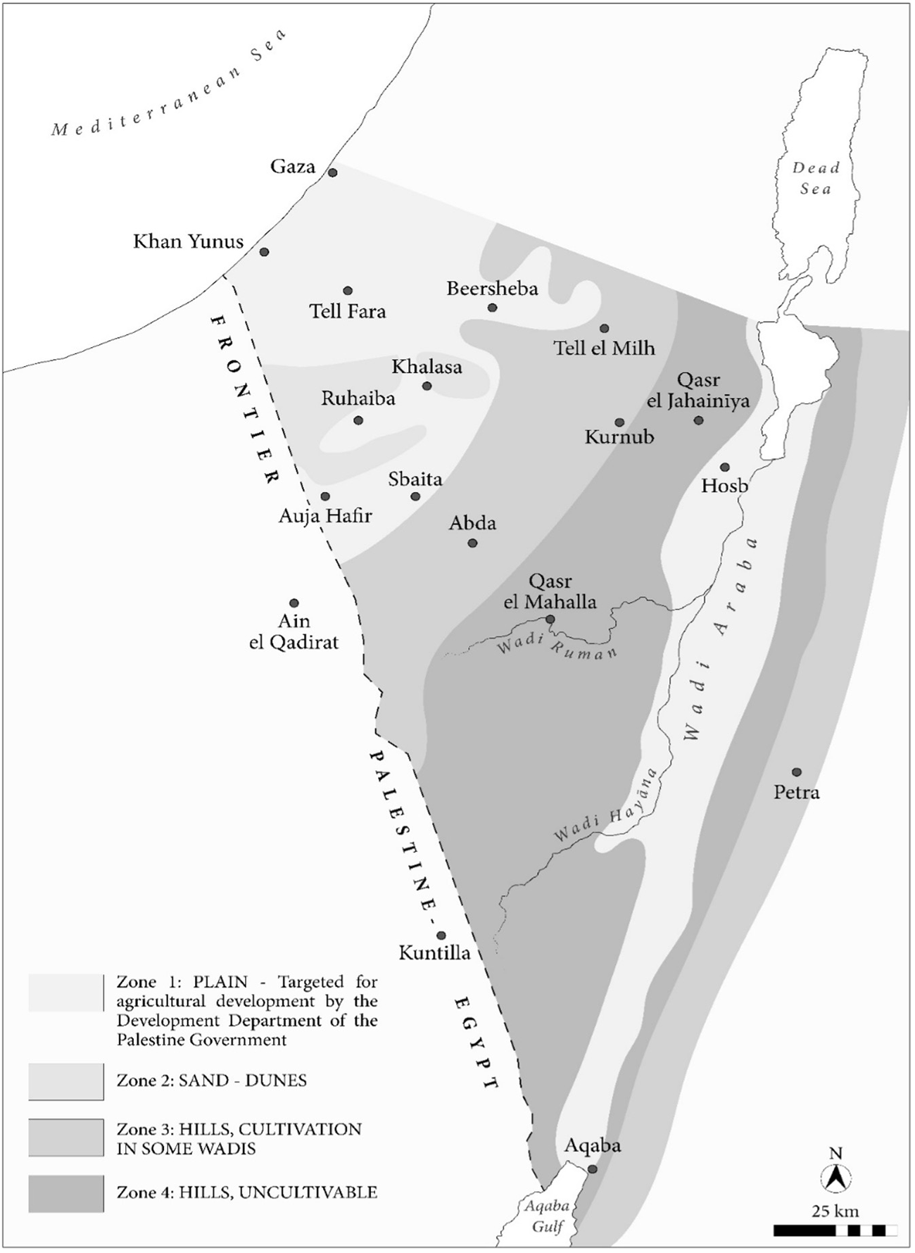
Such ideas found their clearest expression in the preliminary report for the 1937 survey, which proposed dividing the region into agricultural zones ranked by their potential for regreening and urban development. The ‘Byzantine cities’, including Auja Hafir, were placed in Zone 1, which Guy identified as having the greatest potential for future urban growth (Figure 3). These recommendations were partially implemented: by 1947, proposals to establish a new town at Auja Hafir had been formally issued under the Town Planning Scheme.Footnote 62
Map of the 1937 Negev survey by G. E. Kirk, based on the original published in the Palestine Exploration Quarterly. The Negev survey divided the region into four zones defined by agricultural potential.

Figure 3 Long description
The Negev region illustrates four agricultural zones. Zone 1, labeled as ′PLAIN - Targeted for agricultural development by the Development Department of the Palestine Government,′ covers areas like Gaza, Khan Yunus and Auja Hafir. Zone 2, ′SAND - DUNES,′ includes regions such as Beersheba and Tell el Milh. Zone 3, ′HILLS, CULTIVATION IN SOME WADIS,′ encompasses areas like Qasr el Mahalla and Qasr el Jahiniya. Zone 4, ′HILLS, UNCULTIVABLE,′ is marked in the southern part near Aqaba. Key locations such as Petra, Dead Sea and Aqaba are also marked. The map includes a scale bar indicating 25 km and a north arrow for orientation.
The Byzantine Negev in the post-war period, 1945–1960
Whatever Guy’s ambitions may have been for the development of the ‘Byzantine cities’, the ideas were not to reach fruition during the final years of Mandate rule. The Colt project itself, disrupted by the Arab revolt of 1936, the killing of the archaeologist James Leslie Starkey, and the conscription of its participants into the British and US armies during the Second World War, was closed by 1939 and not subsequently resumed.Footnote 63 Delayed by the onset of war, the final publication of the Colt papyri and excavations was also not to appear until over twenty years later. The collapse of the British Mandate and establishment of the State of Israel in 1948, which also ended British suzerainty over archaeological research in the region, also contributed to a general hiatus in excavation work across the Negev in the decade following 1945. Interest in the region’s Byzantine past nonetheless continued as the results of the Colt excavations of the 1930s became better known to academics and government agencies following the publication of the non-literary papyri by Caspar Kraemer in 1958.Footnote 64 For the early Israeli governments of David Ben Gurion and Mosche Sharrett, faced with the challenges of austerity (Tzena), and a nascent state composed of around 60 per cent natural desert, the utility of the Byzantine past in providing a historic precedent for desert greening subsequently became expedient in its perceived ability to address contemporary issues of domestic food sustainability and agricultural development.Footnote 65
Within this context, established conceptions of the Byzantine ‘desert cities’ of Auja Hafir, Subeita and Abadah, with their estimated ancient populations calculated into the tens of thousands, were reimagined as an historic model capable of addressing the concerns of the post-war period. Under the directorship of Theodor Kollek (then director general of the Prime Minister’s Office), formal investigations into the Negev’s potential for ‘desert agriculture’ were initiated in 1950 under the direction of Michael Evenari, Professor of Botany at the Hebrew University.Footnote 66 Evenari’s own investigations in the Negev had begun as early as 1936, and while his personal connection to the Colt project during these early years is not certain, his research was informed by its results. It was also responsive to the work of Philip Mayerson, whose PhD thesis, ‘Arid Zone Farming in Antiquity’, was the first study to make systematic use of the Colt papyri in its efforts to reconstruct the Byzantine Negev’s historic systems of land management.Footnote 67 An abridged form of the work was to appear in volume i of the Colt Project final reports (1962), possibly as a result of his collaboration with Caspar Kraemer during the editing of the Colt papyri, which were to be published in 1958 (as volume iii).Footnote 68
While previous scholarship on the Negev’s Byzantine past had largely confined itself to the hypothetical potential of its (perceived) former agricultural regimes, Evenari was the first scholar to pursue its practical application through the scientific methods of botany and developing technologies of desert agriculture. Projects to reconstruct a ‘Byzantine’ farm at Subeita (later renamed Shivta) and another laboratory farm at Abadah (later renamed Avdat) between 1958 and 1959 – sponsored financially by the Israeli government, the Ford Foundation, the Edmond and James de Rothschild Memorial Group and the Rockefeller Foundation – were followed by attempts at crop introduction inspired by the former crop yields of the Byzantine settlements.Footnote 69
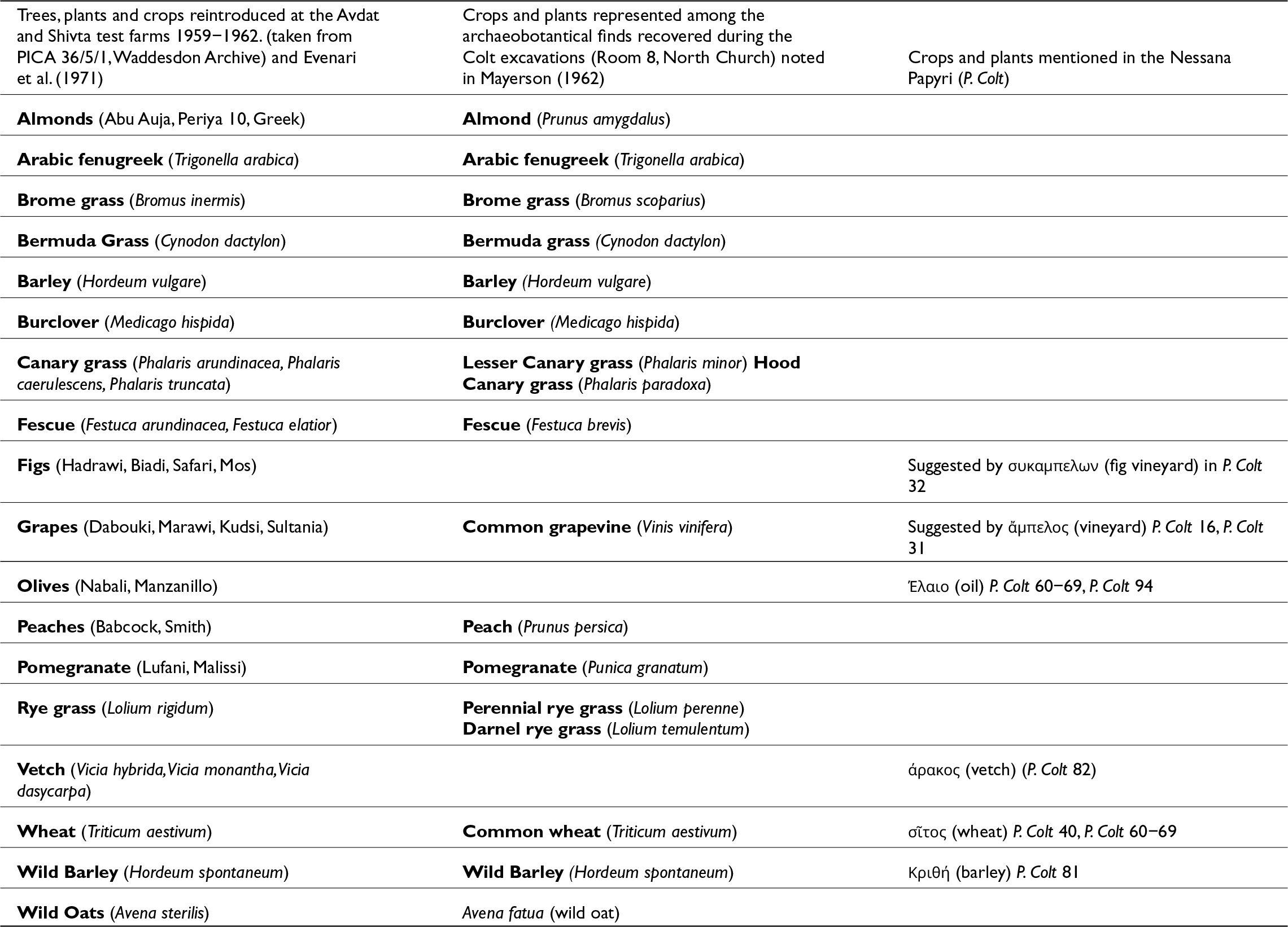
The intellectual strategy of these crop reintroductions was closely informed by reference to the Negev’s Byzantine past. References to crops within the sixth-century Nessana papyri, notably P. Colt 16, P. Colt 31–32 as well as the samples of archaeobotanical remains recovered in Room 8 of the North Church site during the 1930s, formed the basis of a number of experiments to recultivate plants at the test farms in the 1960s aided by the expertise of Zdenka Samish of the Department of Horticulture (see Table 1 for a comparison).Footnote 70 Combined with Michael Evenari’s research into Byzantine systems of run-off farming systems, and aided by the introduction of modern fertiliser, the test farms set out with the explicit intent of recreating the lost agricultural landscapes of the Byzantine Negev, as a future template for the nascent Israeli state. Evenari was also to dedicate extensive statement to the importance of the papyri in his later work The Negev: The Challenge of a Desert (1971), which synthesised his fifteen years of research in the region. Imitating what he understood as ‘Byzantine technologies’, Evenari’s work was central to the reintroduction of run-off farming in the Negev.
A chart demonstrating the correspondence between archaeobotanical finds from the Colt excavations at Auja Hafir, crops mentioned in the Nessana Papyri, and the crop species introduced by Michael Evenari at the Negev test farms

Table 1 Long description
Three columns compare crops and plants listed for Avdat and Shivta test farms in 1959 to 1962, archaeobotanical finds from Colt excavations in Room 8 of the North Church, and crops and plants mentioned in the Nessana Papyri. Rows with entries in both the first and second columns are almonds, Arabic fenugreek, Bermuda grass, barley, burclover, peaches, pomegranate, wheat, wild barley, and wild oats. Brome grass appears in both columns but with different species names, Bromus inermis in the test farms column and Bromus scoparius in the archaeobotanical finds column. Canary grass and fescue also appear in both columns with different species lists, with three Phalaris species and two Festuca species in the test farms column, and Phalaris minor plus Phalaris paradoxa and Festuca brevis in the archaeobotanical finds column. Rye grass appears in both columns with Lolium rigidum in the test farms column and Lolium perenne plus Lolium temulentum in the archaeobotanical finds column. Figs and olives appear only in the test farms column, while the Nessana Papyri column links figs to, sigmaupsilonkappaalpha micropiepsilonlambdaomeganu, grapes to, micropiepsilonlambdasigma, olives to, lambdaalphaiota, vetch to, rhoalphakappasigma, wheat to, sigmatausigma, and barley to, Kapparhoiotatheta, each followed by P. Colt references.
The decades since Evenari’s pioneering experiments have seen no deceleration in the interest extended to the Negev’s Byzantine past and its continued ability to shadow prevailing concerns in the present day. Subsequent research in the 1980s, seeking more nuanced assessments of early Islamic culture, was to usher in a wave of redating and re-examinations of older reports, to demonstrate the longevity of the Negev’s agricultural systems into the eighth and ninth centuries. In more recent years, explorations of questions of identity and climate change have added further layers of discussion to the Byzantine Negev’s reconstructed past. The Byzantine villages of Nessana and Sobata have been imagined as complex spaces of interaction between localised and Roman expressions of identity; situated within the narratives of global or pan-Mediterranean trade; or used as a poignant reminder of the fragility of ecosystems, and the dangers of climate change and monocropping.Footnote 71 The Byzantine Negev thus continues to offer a litmus test for the anxieties of the historian’s present. It also acts as an important reminder that Byzantine Studies, whatever the complexities of its reception, is no less a product of prevailing systems of government and institutional structures, which have shaped the contours of the discipline and the archaeological data from which our understanding of the empire now derives. In this short discussion, I have sought to offer an example of how the legacies of Byzantium could operate in ways that diverge from their more familiar negative connotations, and to show that in Palestine the discipline has deep-rooted connections to Western European political and imperial projects after 1800. As an idealised period of economic expansion and agricultural prosperity, the study of the Byzantine past – as a distinct discipline and field of enquiry – is closely tied to the history of European colonial expansion in historic Palestine, as well as to associated currents of racial science and ethnography. Its legacies have had lasting implications on the delegitimatizing and disfranchisement of its Arab populations, past and present. What it also demonstrates is the contextual and varied nature of early modern receptions of the Byzantine Empire after 1800. Against a wider intellectual culture which frequently saw memories of Byzantine culture elided and denigrated in the popular imaginations of European audiences, the vindication of Byzantium within the history of Palestine served as a critical tool in advancing European claims to the region and attempts to destabilise Ottoman rule. It remains a crucial reminder of the difficulties of reducing the history of reception of Byzantium to a singular narrative or cultural context. As both an inspiration for practices of desert greening and a means of advancing arguments for demographic and political change in the nineteenth century, the development of Byzantine Studies in the region offers valuable insight for specialists of other periods. It represents a further example of the instrumentalisation and entanglement of archaeology within the broader history of colonial rule in the region.
Indeed, with its sizeable quantities of papyri, epigraphy and urban archaeology, the Byzantine past frequently offered the material and quantifiable archaeological data through which developing ideas of Palestine’s prosperous biblical past could be tested and traced. Recognising this intellectual relationship is not simply crucial to building a more nuanced understanding of the afterlife of the Byzantine legacy in this region. Rather, it also serves to reinstate Byzantine archaeology as a subject which has must to contribute to wider dialogues relating to archaeology and colonialism from which it has been traditionally exempted and dismissed.

 Open access

