INTRODUCTION
The chronology and cultural affiliations of Chichen Itza continue to be among the most intractable problems in Mesoamerican archaeology. They are of more than local, or even regional, interest because Chichen Itza displays architectural and artistic similarities to cultures from across Mesoamerica, most prominently with the Toltec capital of Tula, Hidalgo, but also to Xochicalco, Cotzumalhupa, and Epiclassic sites in Veracruz, among others. Therefore, its position in the chronology of Mesoamerica bears upon our understanding of Mesoamerican history as a whole. Because of this, archaeologists have expended considerable effort and ingenuity in positioning Chichen Itza in the stream of history, but, for various reasons, the site has been extremely resistant to a final solution.
The occasion for the present study is a new paradigm that marks a return to a longer and later chronology for Chichen Itza. Prior to the mid-1970s, the prevailing orthodoxy was that the later, so-called “Toltec” or “New Empire” portion of the site flourished between a.d. 1000–1200, that is, after the decline of most of the other cities of northern Yucatan (Brainerd Reference Brainerd1958:Chart 22; Morley Reference Morley1946:83; Tozzer Reference Tozzer1957).Footnote 1 Developed prior to the radiocarbon revolution, this chronology attempted to accommodate ethnohistorical sources, particularly the kʹatun chronicles found in several of the Books of Chilam Balam, to the archaeological record. Many also accepted literally the story of K'uk'ulkan and linked him to Ce Acatl Topiltzin Quetzalcoatl, the legendary Toltec leader from Tula, Hidalgo, and, thus, agreement was also sought with those chronicles from Central Mexico that mentioned events of his life, such as the Anales de Cuauhtitlan.
This consensus splintered in the mid-1970s, as scholars began to argue for a greater overlap between “New” Chichen and the other cities of the north, particularly in the Puuc region (e.g., Andrews V Reference Andrews, Wyllys and Mills1979; Ball Reference Ball and Mills1979a, Reference Ball and Mills1979b; Robles Castellanos Reference Robles Castellanos1980, Reference Robles Castellanos1990). This form of overlap will be referred to as “external overlap,” in contrast to “internal overlap,” referring to any overlap within Chichen between architectural styles and ceramic complexes. The edited volume Late Lowland Maya Civilization (Sabloff and Andrews V Reference Sabloff and Wyllys Andrews V1986) was one of the earliest attempts to survey emerging opinions on the topic. In their influential concluding chapter, Andrews V and Sabloff (Reference Andrews, Wyllys, Sabloff, Sabloff and Wyllys Andrews V1986) cogently presented the range of opinions, from complete external overlap between Chichen Itza and the other norther cities, as espoused by Lincoln (Reference Lincoln, Sabloff and Wyllys Andrews V1986), to a partial overlap in which Chichen Itza persisted for a limited time after the demise of the northern cities. This focused attention on the late ninth and early tenth centuries as the span of overlap. Today, few would accept total internal overlap, as most authorities now recognize that construction of the so-called “Toltec” or Modified Florescent buildings, such as the Castillo, postdates architecture from Old Chichen, built in the Pure Florescent or “Puuc” style, by some span of years. Still it is worth underscoring that, although construction dates may have been offset somewhat, this by no means implies that earlier buildings were no longer occupied after the close of the Pure Florescent, or that elements of the Modified Florescent style did not appear before its full manifestation.Footnote 2
Our own contribution to this debate, following suggestions by Robles Castellanos (Reference Robles Castellanos1990), was to argue that monumental construction ceased at Chichen Itza at about the time New Chichen was formerly thought to have begun, that is, a.d. 950–1050, just as new ceramic types were introduced, known as the Hocaba complex (Ringle et al. Reference Ringle, Bey and Peraza Lope1991).Footnote 3 A later paper by Ringle et al. (Reference Ringle, Gallareta Negrón and Bey1998) concluded it was better to consider Chichen Itza as an Epiclassic site, rather than Terminal Classic or Early Postclassic, to emphasize its participation in a network of sites throughout Mesoamerica that claimed the feathered serpent as their chief political image. We also argued for settlement continuity between Old and New Chichen and a relatively short span between construction episodes. Occupation continued after the appearance of the Hocaba complex, but construction was mainly limited to modest repairs and renovations rather than new buildings (Schmidt Reference Schmidt, Kowalski and Kristan-Graham2007:157). In our view, the Hocaba complex was not a full complex but overlapped with the conclusion of the Sotuta phase and the inception of the following Tases phase. Since Hocaba was considered to be diagnostic of the Early Postclassic and because, in their view, Chichen Itza had ceased to be a growing power by a.d. 1050, Andrews et al. (Reference Andrews, Wyllys Andrews V. and Robles Castellanos2003) characterize the following century as a “dark age” and urge that the Early Postclassic be abandoned as a meaningful category.
In contrast, the claim of the new paradigm for a longer and later chronology implies a shift towards little or no internal or external overlap, but now based upon archaeological evidence from two sources. The first is the work of Eduardo Pérez de Heredia, who carried out much of the ceramic analysis for recent INAH projects and whose ceramic analysis argues for a later placement of the Sotuta Complex, the ceramic complex usually associated with the “Toltec”/ “Mexicanized”/ Modified Florescent occupation of New Chichen. The second results from recent work by archaeologists from the University of California, San Diego (UCSD). This work was under the direction of Geoff Braswell and formed part of the larger “Chichén Itzá: estudio de la comunidad del Clásico Tardío” project organized by Cobos Palma.Footnote 4 The UCSD sub-project consisted of excavations in the Gran Nivelación (also known as the Great Terrace or Great Platform) between the Castillo and the West Colonnade, as well as another operation investigating a portion of the precinct wall near the Great Ballcourt. Although I offer alternate interpretations of the data supplied by Pérez de Heredia and the UCSD team, it is only because of the high standards of their fieldwork and the prompt divulgation of their results that such discussions are even possible. Finally, this chronology has also been endorsed in a recent popular presentation of Maya archaeology (Coe and Houston Reference Coe and Houston2015).
Although it is sometimes claimed that Chichen Itza is a poorly dated site, it is not for want of dates. Chichen Itza has more radiocarbon dates than many other large sites, certainly more than any other site in northern Yucatan. Eleven radiocarbon dates have been published, including a retake and five from the recent UCSD project (Volta and Braswell Reference Volta, Braswell and Braswell2014:Table 13.2). Heajoo Chung et al. (Reference Chung, González, Ramírez, Schaaf and Lee2010) ran eight thermoluminescence dates on pottery from or related to Chichen Itza,Footnote 5 while Trembour (Reference Trembour and Coggins1992) reported 46 obsidian hydration dates from the Great Cenote and elsewhere at Chichen Itza.Footnote 6 Over 50 hieroglyphic dates can be fairly securely anchored in the Long Count (for a current list, see Volta and Braswell Reference Volta, Braswell and Braswell2014:Table 13.1).Footnote 7 The Books of Chilam Balam provide putatively absolute dates in the form of kʹatun chronicles, and if Quetzalcoatl is considered, the Central Mexican annals can be invoked. In addition to absolute dates, relative dating sequences have been developed on the basis of excavations, pottery styles, architectural seriations, and art styles, sometimes involving cross-dating with other sites. Four reasonably full ceramic analyses have been carried out by Brainerd (Reference Brainerd1958), Smith (Reference Smith1971), Lincoln (Reference Lincoln1990), and Pérez de Heredia (Reference Pérez de Heredia Puente2007, Reference Pérez de Heredia Puente2010, Reference Pérez de Heredia Puente2012).
The difficulty is rather the lack of agreement among datasets. Each set has its own limitations and sources of error. For example, hieroglyphic dates, with but a few exceptions, are confined to a narrow window of the late ninth century and are not associated with the structures on the Gran Nivelación. Since several texts have clearly been reset, each must be understood in their archaeological context, such as the Initial Series lintel, the circular stone from the Caracol, and the stone “hat” said to be from the Great Ballcourt. Furthermore, it is not always clear what events are being commemorated and how they relate to the occupation of the structure. The problems of the kʹatun chronicles are also well-known. The manuscripts we possess date to the eighteenth century or later, and so postdate the actual events at Chichen by 500 to 800 years, with no intervening textual trail. Although some have claimed that they were transcriptions of glyphic texts, the dates themselves seem contrived, as Bricker (Reference Bricker1981) and others have pointed out. The frequency with which the major events of northern Yucatan happen within a kʹatun 8 Ajaw is suspiciously like the prominence of the year 1 Flint in the Mexica chronicles.
Another complicating factor was voiced nearly 30 years ago by Andrews V and Sabloff (Reference Andrews, Wyllys, Sabloff, Sabloff and Wyllys Andrews V1986:450):
It behooves us to remember that different classes of material culture may not be telling us the same things and that the association among them cannot be assumed. … One forms very different conclusions, for example, about the nature of the Toltec presence in the Maya lowlands by looking at Toltec and Puuc architecture and art, on the one hand, and at the Sotuta and Cehpech ceramic spheres on the other. They did not go hand in hand, and what understanding we have of the Toltec phenomenon results in part from tracing their interaction.
We thus need to be clear not only about the reliability of our chronologies, but also about the limits of inference. As Andrews and Sabloff note, no very convincing argument has been put forth about why pottery production should have changed in concert with architectural styles, since they presumably emanated from opposite extremes of the social spectrum. Furthermore, Cehpech (the ceramics used by most inhabitants of Late and Terminal Classic northern Yucatan) and Sotuta ceramics (used at Chichen Itza) differ in degree rather than kind (Smith Reference Smith1971:191–192), such that even experienced ceramicists often have difficulty distinguishing slate wares from the two complexes. The distinctive “foreign” traits of the Sotuta complex are confined mostly to two trade wares, Silho Fine Orange and Tohil Plumbate, probably produced along the lower Usumacinta and on the Pacific slope near the Guatemalan–Mexican border, respectively (Bishop Reference Bishop, Scott and Meyers1994). Thus, the sculptural and architectural parallels tying Chichen Itza to western Mesoamerica are likely to have followed pathways distinct from those responsible for the importation of plumbate and fine orange pottery. The latter is, in fact, absent at Tula (Bey and Ringle Reference Bey, Ringle, Kowalski and Kristan-Graham2007:378).
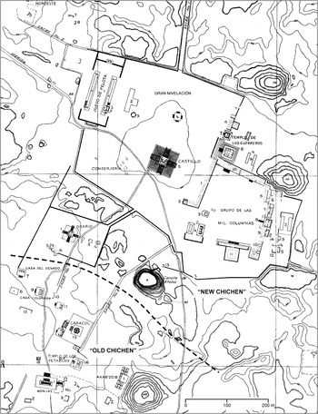
In this study I will be concerned mainly with stratigraphy, architectural sequences, and radiocarbon dates. Superpositions of buildings, such as the Temple of the Warriors and its substructure, the Temple of the Chac Mool, leave no doubt as to the construction sequence and, because we must assume that buildings were constructed to be used for some period of time, indicate significant lapses of time between major superpositions, probably a decade at a minimum. Next most trustworthy are construction stages connected horizontally by features such as floors. This is the type of information derived from pits by the Carnegie Institution between the Northwest Colonnade, the Temple of the Warriors, and the Castillo and from the recent UCSD excavations that also link the two areas (Figure 1). The interval between the structures built at opposite ends of these units is, however, unknown. It may have been decades, but the two could have also been constructed at approximately the same time. For example, the Carnegie work demonstrated that the Temple of the Chac Mool postdates the final Castillo, but since the decoration applied to their basal platforms is identical, as are various other details, construction of the two may have been virtually contemporaneous. Stratigraphic relations between the great majority of structure construction stages are still limited, however. With the exception of the Initial Series Group, the structures of Old Chichen (Figure 2) have not been connected to each other stratigraphically, much less to New Chichen. Likewise, no stratigraphic connection ties the Osario Terrace to any other group. Within the Gran Nivelación, the Castillo, Castillo-sub, Temple of the Warriors, Temple of the Chac Mool, and sections of the Court of a Thousand Columns have been connected stratigraphically, but the Great Ballcourt, Tzompantli, the Temples of Venus and Jaguar and Eagles, the Temple of the Big Tables, the Mercado, and the east and south wings of the Court of 1000 Columns have not, at least in publication.
Plan of the excavation units of the Carnegie Institution and the UCSD. The pit placements of the Carnegie excavations are hypothetical, although the beginning and end points are reasonably accurate. Modified after Braswell and Peniche May Reference Braswell, Peniche May and Braswell2012:Figure 9.5.

Map of central Chichen Itza, showing major structures mentioned in the text. Map modified from the Kilmartin and O'Neil map (Ruppert Reference Ruppert1952:Figure 251).

PÉREZ DE HEREDIA'S CHRONOLOGY
The new paradigm for “Toltec” period or Modified Florescent Chichen Itza was first proposed by Pérez de Heredia (Reference Pérez de Heredia Puente2010) in his dissertation on the ceramics excavated over the last two decades by Schmidt's INAH project. It is extremely valuable in being the only available record for several of the operations he tabulates. An important finding of Pérez de Heredia's (Reference Pérez de Heredia Puente2010, Reference Pérez de Heredia Puente2012) analysis is the substantial number of pre-Sotuta deposits throughout both “Old” and “New” Chichen, apparently in association with Pure Florescent structures. Previous excavators had found few such deposits, leading some to assume that all visible architecture belonged to the Sotuta phase (but see Brainerd Reference Brainerd1958:35–36, 38–39).
Of central importance here is Pérez de Heredia's dating of the Sotuta ceramic complex, universally acknowledged to correlate with Modified Florescent architecture at Chichen Itza and frequently taken as an index of Itza presence. His chronology is based not on any new absolute dates, but instead on stratigraphic and comparative arguments. Unfortunately, his conclusions are often difficult to evaluate because he usually presents only aggregate statistics for the pottery from these excavations (i.e., counts reflect the entire contents of an excavation unit, rather than individual levels), and then only in terms of complexes. Thus, information on individual types and their positions within ceramic columns is as yet unobtainable, as are changes in frequencies as one moves from top to bottom in excavation units. Many cases have no accompanying stratigraphic information or pit profiles.
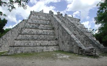
Pérez de Heredia argues that Sotuta ceramics did not appear until well into the tenth century. Key to his dating of this phase are Schmidt's excavations in the terrace and basal platform of the Osario/High Priest's Grave (Str. 3C1). The Osario (Figure 3) is a Modified Florescent radial pyramid with strong similarities to the Castillo, and oddly for New Chichen, a hieroglyphic date of a.d. 998 in its upper chamber, the latest at Chichen Itza (Graña-Behrens et al. Reference Graña-Behrens, Prager and Wagner1999; Thompson Reference Thompson1937). Pérez de Heredia's (Reference Pérez de Heredia Puente2010:188–191, 395) analysis of the Osario terrace pits showed a relatively low frequency of Sotuta sherds in both operations, between 19–23 percent, leading him to conclude that both deposits date to relatively early in the production history of Sotuta ceramics. Taking the hieroglyphic date as falling close to the construction date of the Osario, and allowing a prior 50–70 years for the development of Sotuta ceramics, he proposes a.d. 930–950 as a reasonable estimate for the start of the Sotuta phase. The Osario would then be among the earliest of the Modified Florescent structures. Given the volume and extent of Modified Florescent architecture he believes postdates the Osario, Pérez de Heredia (Reference Pérez de Heredia Puente2010:269) argues for a terminal Sotuta date of around a.d. 1100/1150.
The Osario or the High Priest's Grave. Photograph by the author.

Dating (and seriating) excavation lots by ceramic frequencies is an explicit methodology of Pérez de Heredia's dissertation (Reference Pérez de Heredia Puente2010:16–27; also Pérez de Heredia Reference Pérez de Heredia Puente2004). In the case of Sotuta, early and late facets are differentiated not by any differences in the inventory of types or attributes, but solely by type frequencies. Seriation by frequencies is fairly standard archaeological practice, but in this case is problematic for several reasons.Footnote 8 First, many of the lots are extremely small. Pérez de Heredia (Reference Pérez de Heredia Puente2010) reports statistics on 93 distinct contexts, by my count. Of these, 36 have over 1000 sherds, and an equal number have less than 100, clearly suggesting varying formation processes. The former group, clearing operations and dump deposits, ranged into the tens of thousands. Many of the latter group come from construction fill, especially platforms and terraces, including all of the Osario, Castillo and Great Terrace units that were not clearing operations. The fraction of unidentified sherds also tends to be higher in the latter group. This suggests that fill quarrying took place in areas that were lightly inhabited and had been for some time, exposing a greater number of ceramics to erosion. This resulted in deposits with a disproportionate number of sherds substantially earlier than the moment of quarrying and construction. Dating by ceramic frequencies is, therefore, a doubtful methodology in such cases, and sherds from such lots provide at best a terminus post quem for fill deposits.
Another problem with small lots is that sampling error increases significantly, since the presence or absence of one or two sherds can move such samples to a different facet. To give just a few examples, he reports only one of several units placed in the terrace of the Castillo, and then only the results from between Floors 3 and 4, with a total of 16 sherds (Pérez de Heredia Reference Pérez de Heredia Puente2010:106, Chart 8). Another at the base of the east stairway of the Castillo had a total of only 26 sherds (Pérez de Heredia Reference Pérez de Heredia Puente2010:158–159). A “rubbish deposit” under the east stairway of the Osario had only 89 sherds, 25 of which were unidentified; another from under the serpent head on the west stairway yielded only 69, with 12 unidentified (Pérez de Heredia Reference Pérez de Heredia Puente2010:189, Chart 31). A final factor, noted by Pérez de Heredia (Reference Pérez de Heredia Puente2004:10–12), is the effect recovery techniques such as screening had on the dating of deposits; it is not clear if this was standard excavation procedure for the units he reports.
An even more serious flaw in his argument is his choice of the Osario to anchor the beginning of the Sotuta phase. Despite the frequency argument, it seems instead this was done simply because the Osario has a hieroglyphic date. The Castillo may have been built on an equally early terrace, since he notes that: “[m]any of these test-pits [into the Gran Nivelación] show terrace levels sealed by floors with construction fills of pure Yabnal-Motul Complex deposits” (Pérez de Heredia Reference Pérez de Heredia Puente2010:106), that is, from the phase preceding Sotuta. Furthermore, because there was seemingly not enough time for much Modified Florescent construction prior to the a.d. 998 date of the Osario, and because other Modified Florescent structures are associated with much larger fractions of Sotuta pottery, Pérez identifies the Osario as a “transitional” building (Pérez de Heredia Reference Pérez de Heredia Puente2010:188), belonging to a group including the Caracol, the Castillo-sub, the Temple of the Chac Mool, Temple of the Little (sic.?, Big?) Tables-sub, and Str. 5B18 (the Old Castillo), despite the absence of ceramic information to support his position (Pérez de Heredia Reference Pérez de Heredia Puente2010:190). The net result is to shift the Sotuta phase forward in time by placing construction of the Castillo, Great Ballcourt, and the other visible structures of the Gran Nivelación in the latter part of the Sotuta phase, after the Osario.
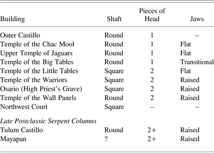
Pérez's transitional group is a puzzling construct, because the hieroglyphic dates from the Caracol are a century earlier than the Osario date, and because Carnegie archaeologists had established that the Temple of the Chac Mool postdates the Castillo and, hence, could not be a close contemporary of the Castillo-sub. Clearly this group comprises a multitude of architectural styles. In contrast, Schmidt (Reference Schmidt, Kowalski and Kristan-Graham2007:177), who directed excavations of the Osario, accepts the hieroglyphic date, but argues that it was contemporary with or somewhat after the Temple of the Warriors, noting the presence of hombre-pajaro-serpent panels and long-nosed corner masks on both. Supporting this is a seriation of serpent temple columns made by Kubler (Reference Kubler1982; see also Tozzer Reference Tozzer1957:vol. 12, p. 43). Kubler examined three traits: the number of stones forming a column, whether the column was round or square in cross-section, and whether the jaw of the serpent was flat or raised. The Osario very clearly aligns with the Temple of the Warriors, which, on stratigraphic grounds, postdates its substructure, the Temple of the Chac Mool, the Castillo and its substructure. Furthermore, if Postclassic serpent columns are added to the seriation, the Osario and Temple of the Warriors columns fall between them and the other serpent columns from Chichen Itza (Table 1).
Traits of the serpent columns at Chichen Itza. Additional Chichen data from Kubler (Reference Kubler1982) and Tozzer (Reference Tozzer1957), Lothrop (Reference Lothrop1924:33, Figure 11) for Tulum, and Proskouriakoff (Reference Proskouriakoff, Pollock, Roys, Proskouriakoff and Smith1962:95, Figures 6–7) for Mayapan.

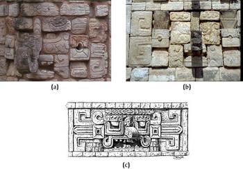
As Schmidt noted, the similarities of the masks on the Osario and the Temple of the Warriors are even more striking, both contrasting with those from Old Chichen (Figure 4). The Osario and Temple of the Warriors masks share a pattern of dots and x's on their cheeks and in their supraorbital plate (the Castillo mask has the latter, but not the former). They both have stacked trapezoidal elements above and below their square ear ornaments, in contrast to pendants of small triangles in many of the Pure Florescent masks and the Castillo. They also wear a banded headdress with a rosette at its center, again in contrast to the others (though similar to masks from the House of the Governor at Uxmal). Construction techniques also differentiate them from the others: the Osario and Temple of the Warriors have larger and fuller suborbital/cheek pieces not found in the others. Thus, there are clear grounds for considering the Osario a late structure, most probably built about the time of its Venus platform (3C-3). It follows, therefore, that most of the visible architecture on the Gran Nivelación was the product of tenth century construction projects, and there is nothing at this time to indicate a prolonged spate of construction beyond that.
Comparisons of masks from (a) the Temple of the Warriors, (b) Osario, and (c) Las Monjas, showing the close similarities of the first two. Photographs by the author. Illustration from Seler (Reference Seler, Thompson, Richardson and Comparato1998:Figure 48).

THE SAN DIEGO PROJECT
The UCSD team is the second set of authors in support of the new chronology (Braswell and Peniche May Reference Braswell, Peniche May and Braswell2012; Peniche May et al. Reference May, Nancy, Hahn and Braswell2009; Volta and Braswell Reference Volta, Braswell and Braswell2014). The conclusions of the 2014 paper differ from the earlier 2012 paper for two reasons. The first paper, published without the radiocarbon dates and without reference to Pérez de Heredia's dissertation (though to earlier work of his), generally accepts a partial overlap model, stating that “it is clear that virtually all visible structures were built during a time when Sotuta pottery was dominant at Chichen Itza and minor amounts of Cehpech pottery were consumed at the site” (Braswell and Peniche May Reference Braswell, Peniche May and Braswell2012:230). The second paper presents five new radiocarbon dates from excavations and, because the ceramics from their excavation were not available for analysis, places considerable reliance on Pérez's dissertation. Influenced in part by INAH recovery of pre-Sotuta deposits, this paper suggests the possibility of a hiatus of some sort during the early to mid-tenth century, before the introduction of Modified Florescent architecture (what they term the “International Style”).
Stratigraphy
While Pérez hung his chronology on the Osario, the Castillo is the peg for the San Diego group, whose primary evidence is the stratigraphy of their excavations into the Gran Nivelación between the Castillo and the West Colonnade of the Group of a Thousand Columns. This same ground was probed some 75 years earlier by Earl Morris of the Carnegie Institution in an attempt to link his excavations around the Temple of the Warriors to the Castillo by trenching across the plaza (Morris et al. Reference Morris, Charlot and Morris1931:165–172). A few years later, the Yucatecan archaeologist Erosa Peniche (Reference Erosa Peniche1947, Reference Erosa Peniche1948) discovered a substructure underneath the Castillo (the Castillo-sub). Schmidt's (Reference Schmidt, Kowalski and Kristan-Graham2007) excavations of the Temple of the Big Tables and pits into the Gran Nivelación for installation of the sound-and-light show closed out the twentieth century, but, as yet, these have been only partially published. The importance of the UADY-UCSD work is that it self-consciously returned to establishing stratigraphic connections between the structures defining this critical region of Chichen Itza.
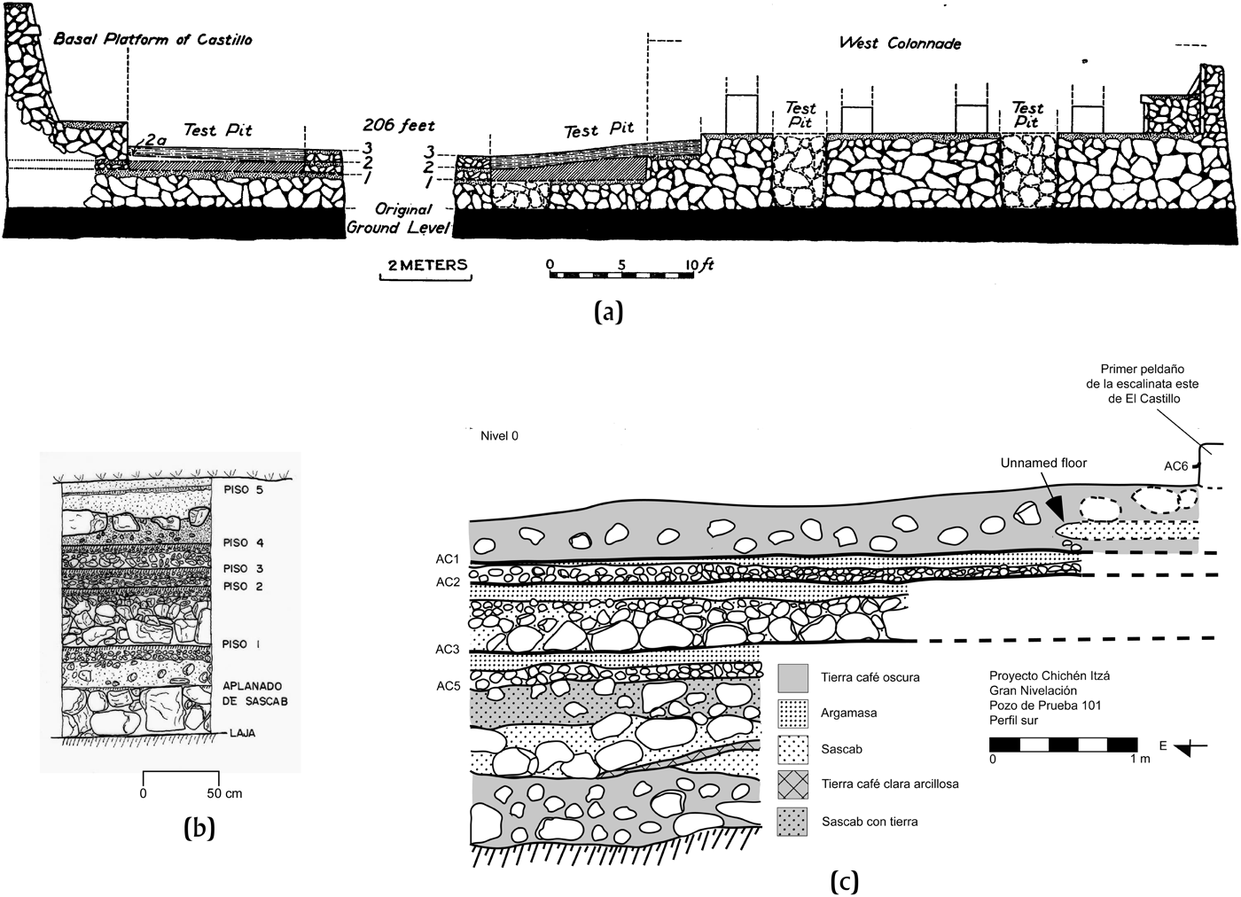
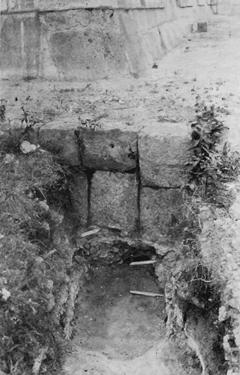
The Carnegie trench (Figures 1 and 5a) consisted of six test pits, 7.7–9 m apart, along a line connecting the West Colonnade, 2.29 m south of its point of disappearance beneath the Northwest Colonnade, with the Castillo terrace (Morris et al. Reference Morris, Charlot and Morris1931:166–167). No map of the units was ever published, but the photograph of the western extreme shows that it arrived just south of the northeast corner (Figure 6). Three plaza floors were noted by the Carnegie project: the latest, Floor 3, only survived where it articulated with the Castillo terrace and the West Colonnade. Although the San Diego group cautions that there is no assurance that Floors 1–3 extended across the entire expanse, Morris (Morris et al. Reference Morris, Charlot and Morris1931:167) specifically states, “In every pit, the lower two of the major floors were encountered,” that is, Floors 1 and 2. At its eastern end, Floor 1, the lowermost, articulated with the base of the West Colonnade, while Floor 2 raised the plaza floor until it was flush with a terrace edge bordering the west side of the West Colonnade. The largely disintegrated Floor 3 then raised the plaza surface to within 15 centimeters of the upper edge of the colonnade. Floor 2 was tinted red and Floor 1 is described as “brownish.” Test pits in the West Colonnade itself revealed no substructures or earlier floors, indicating it was built at the same time as Floor 1.
Excavation units in the Gran Nivelación (Great Terrace) east of the Castillo. (a) Profile of the Carnegie trench (Morris et al. Reference Morris, Charlot and Morris1931:Figure 106), (b) INAH pit near the east façade of the Castillo (Pérez de Heredia Reference Pérez de Heredia Puente2010:Figure 114), and (c) UCSD Pit 101 (Volta and Braswell Reference Volta, Braswell and Braswell2014:Figure 13.6).

West end of the Carnegie trench in the Gran Nivelación, showing its articulation with the low terrace surrounding the Castillo. Arrows point to Carnegie Floors 1, 2, and 2a, bottom to top. Floor 2 is 10 cm below the base of the terrace facing. Floor 1 is 30.5 cm below the base (Morris et al. Reference Morris, Charlot and Morris1931:167). Photograph from Morris et al. Reference Morris, Charlot and Morris1931:Figure 105.

At the western end, the trench abutted the edge of the low terrace surrounding the Castillo and a little over two meters from its base. Floors 1 and 2 could be seen to run beneath the edge of the Castillo terrace, at depths of 30.5 and 10 cm, respectively, but a re-flooring of the latter, labeled 2a, lapped up onto it. Floor 3 was found “[s]loping downward [from the terrace retaining wall] to tail out and merge with the second or middle major floor” (Figures 5a and 7; Morris et al. Reference Morris, Charlot and Morris1931:167). Thus, the Carnegie excavations indicate the Castillo must have rested on one of the lower two floors.
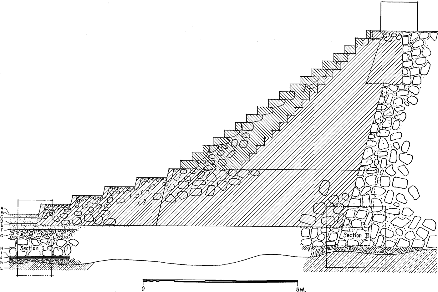
Profile of the lower-section stairway of the Caracol, showing how its construction stages articulated with various plaza floors. Note particularly the additions to the staircase. Reproduced with permission from Ruppert Reference Ruppert1935:Figure 57.

Schmidt's project also excavated a pit in the area, identified only as being from the east façade of the Castillo (Figure 5b; Pérez de Heredia Reference Pérez de Heredia Puente2010:158–159, Figure 114). Five floors were identified, numbered one to five, bottom to top. The pit profile indicates a thin upper floor followed by three closely set stucco floors. Below the lowermost of these (INAH Piso 2) is a substantial amount of fill and then the lowest floor, Piso 1, below which is an even thicker layer of floor fill and heavy rubble, possibly with a sascab floor between them. Pérez reports the uppermost three layers had only Cehpech and Yabnal-Motul ceramics, although totaling only 26 sherds, six of which were unidentified.
The UCSD units are generally to the south of the Carnegie trench and are aligned along a line perpendicular to the alignment of the Castillo and West Colonnade, extending from the center base of the east Castillo stairway to the Western Colonnade (Figure 1; Volta and Braswell Reference Volta, Braswell and Braswell2014:Figure 13.2). Not only was this operation nearly continuous from end to end, but wider areas of the plaza were opened up, including a long side trench extending north from this central east-west trench. The stratigraphy of the UCSD excavations is considerably more complex than the Carnegie trench, including several buried and razed structures, as well as evidence for more than three floors. Since their units were significantly further south than the Carnegie trench, Braswell and Peniche May (Reference Braswell, Peniche May and Braswell2012:234) note that Morris may have crossed a relatively unimpeded expanse of the plaza, but the relatively short interval between pits makes it unlikely he missed anything major.
The UCSD team was able to match up their floors with Carnegie Floors 1–3 at their juncture with the West Terrace, but had greater difficulty aligning them where they arrived at the Castillo (Figure 5e); in fact, the 2012 paper presents contradictory accounts. At its conclusion, they place the Castillo and their Floor AC6, the final floor, of which only traces remained near the stairway edge, in their Construction Stage VIII because: “[t]races of the plaster surface of Feature AC6—perhaps representing the resurfacing of the floor—are preserved on the first step of the eastern stair of the Castillo” (Braswell and Peniche May Reference Braswell, Peniche May and Braswell2012:252). This stage they date to the second half of the tenth century. Regarding the earlier AC1 floor they state: “we are certain, however, that plaster floor Feature AC1 predates the Castillo because it passes a significant distance beneath the eastern stair of the pyramid, which is built on ballast fill placed on top of plaster floor Feature AC1” (Braswell and Peniche May Reference Braswell, Peniche May and Braswell2012:251). In discussing the Carnegie excavations earlier in their article, however, they recognize that Carnegie Floor 2 ran beneath the base of the surrounding terrace and state that: “Carnegie Floor 3 dates to some time after the construction of the Castillo … At the Castillo, Carnegie Floor 3 most likely corresponds with floor Feature AC6,” contradicting their concluding statement. As for the other two Carnegie Floors, “[a]t the Castillo, Carnegie Floor 1 is either our plaster floor AC1 or the more deeply plastered floor AC2,” and “Carnegie Floor 2 could be either our plaster floor Feature AC1 or an unnamed plaster floor (found only in Test Pits 128 and 154). The latter identification seems more plausible….” (Braswell and Peniche May Reference Braswell, Peniche May and Braswell2012:235).
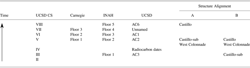
Before considering the connection of structures to floors, comparison of the three stratigraphic profiles suggests a resolution as to how floors align (Table 2). Although the scale of Pérez de Heredia's pit profile (Figure 5b) is unspecified, the relative distances between its floors match those in Pit 101 almost exactly. In both cases, the final floors (AC6 and INAH Piso 5) are thin and appear to lack a prepared subfloor, though almost nothing of AC6 survived. The next three, evenly spaced about 20 cm apart, judging from the profiles, lie above typical sub-floor fill, although relatively little of the UCSD “Unnamed Floor” survived. Below both AC2 and Piso 2 is a deeper layer of heavier rubble before reaching Floors AC3 and Piso 1, respectively. Carnegie Floor 1 almost certainly aligns with AC2 and Piso 2 and, because the two floors above (Carnegie Floors 2 and 3) appear to have prepared subfloors and are closely set,Footnote 9 they are likely aligned with the floors shown in Table 2. The final floor (AC6/INAH Piso 5), probably a very late and crude attempt at resurfacing the Gran Nivelación, does not appear in the Carnegie trench, either because it did not extend to the Carnegie trench or had eroded completely.
Proposed alignment of floors and structures on the Gran Nivelación. UCSD Construction Stage (UCSD CS) data from Braswell and Peniche May (Reference Braswell, Peniche May and Braswell2012). Carnegie data from Morris et al. (Reference Morris, Charlot and Morris1931:165–175). INAH data from Pérez de Heredia (Reference Pérez de Heredia Puente2010:158–159, Figure 114). UCSD data from Volta and Braswell (Reference Volta, Braswell and Braswell2014:Figure 13.6). Data for Structure alignment A from this paper and from Braswell and Peniche May (Reference Braswell, Peniche May and Braswell2012:Figure 9.19 B).
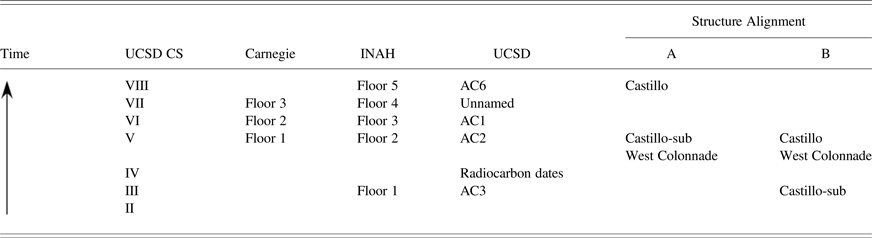
In trying to match buildings to floors, a first point to be made is that the neither the Carnegie nor the UCSD trenches penetrated to the base of the Castillo (Figures 5a and 5c). The Carnegie excavation abutted the east edge of the basal platform/terrace, exposing its base but did not continue farther (Figure 6). The only comparable unit of the UCSD operation, Pit 101, came to the edge of the lower tread of the east stairway, but, again, did not continue beyond that (Figure 1). Yet the “Unnamed Floor” seems to run somewhat farther below the bottom of the east stairway than Floor 2 runs beneath the terrace edge. The difficulty may be explained by Morris's comments on a Mexican clearing operation on the north edge of the Castillo, where he observed that the stairway serpent heads on the north side were bedded on the last floor, Floor 3. As he notes, “[a] further inference from the latter condition is that the third or final court level had been constructed before the balustrades of the north stairway were completed” (Morris et al. Reference Morris, Charlot and Morris1931:175). If this is also true of the east stairway, it would explain the apparent association with San Diego Floor AC 6 and the greater distance down to the floors below it. A gap between the construction date of the Castillo and its stairways may have resulted either from an as-yet-to-be-discovered earlier stairway or perhaps use of a temporary stairway during construction of the Castillo, as is known for many buildings. Although the Castillo stairways have not yet been excavated, Ruppert's (Reference Ruppert1935:Figure 57) cross-section of the lower platform stairway of the Caracol shows exactly this scenario (Figure 7). Note how the main platform is two construction stages earlier than that of the final staircase.
If we accept that Carnegie Floor 3 and its correlate, the UCSD “Unnamed Floor,” postdate the Castillo, putting the latter on AC1/Carnegie Floor 2 would place its construction during UCSD Construction Stage VI (rather than VIII). But could it possibly have been built even earlier, on Floor AC2/Carnegie Floor 1? Braswell and Peniche May (Reference Braswell, Peniche May and Braswell2012:235, 250) argue that comparative elevations indicate that AC2/Carnegie 1 is the floor lipping onto the Castillo-sub,Footnote 10 but no direct stratigraphic connection has been established by excavation. Erosa Peniche (Reference Erosa Peniche1948:14) mentions the situation in front of the Castillo-sub was considerably more complex: “[a]ntes de ascender por la escalinata, pueden apreciarse cinco diferentes revestimientos del pavimento bien conservados que corresponden a épocas distintas” (“Before ascending the stairway, five different well-preserved renovations to the flooring that belong to distinct episodes can be noted”). Whether these are full re-flooring episodes or simply re-plastering of the surface is unclear. Braswell and Peniche May (Reference Braswell, Peniche May and Braswell2012:247–248) further speculate that some of the floors below their AC2 may extend from yet another sub-pyramid below the known sub. As they state: “we suspect that such a structure exists, and that it was in Stage III that the basic plan of the Great Platform—consisting of a large platform built with elements of the International style and supporting a central pyramid—was established” (Braswell and Peniche May Reference Braswell, Peniche May and Braswell2012:248). Stage III was also the period during which the orientation of the plaza structures was reestablished but before construction of the first full floor of the Gran Nivelación.
It cannot be the case that there remains an as-yet undiscovered substructure of any size beneath the Castillo-sub, however. Erosa Peniche originally approached the Castillo by means of a tunnel begun at ground level at the midpoint of the south stairway. Later he shifted to an approach from the northern side (where visitors enter today), but, at the end of the 1936 campaign, he returned to continue the south tunnel. His brief summary of this work states: “ [l]a exploración de la pirámide por el túnel practicado en el frente Sur llegó a treinta y tres metros sin encontrar otra estructura” (“[t]he exploration of the pyramid by the tunnel effected at the south front reached a length of 33 m without encountering another structure”) (Erosa Peniche Reference Erosa Peniche1947:247; translation by the author). This distance indicates he had penetrated to the center point of the Castillo without encountering substantial construction.
This leaves platform/floor AC3 without a major focus to guide reorientation of subsequent structures. The logical solution is that this was the original support for the Castillo-sub (hence moving it from UCSD Construction Stage V to III). The great advantage of this alignment is that it resolves an apparent contradiction in the construction history of the first full terrace, Carnegie Floor 1. Both Morris and the San Diego group are agreed that this was coeval with the West Colonnade, an undoubted Modified Florescent structure with a colonnade and a battered lower wall zone. The Castillo-sub is, however, clearly transitional, with a vertical lower wall zone, among other Pure Florescent traits, and, thus, stylistically would seem to antedate the West Colonnade. If it is argued instead that the Castillo was the first partner of the West Colonnade on the Gran Nivelación, the problem disappears. If true, the Castillo probably rests on the lowermost full floor of the Gran Nivelación, since Carnegie Floor 1 covers a layer of heavy ballast that would better reflect the massive construction project that the Castillo must have entailed, rather than the modest 20 cm increase represented by Floor 2. The Castillo, the West Colonnade, and the first full floor of the Gran Nivelación would then all date to UCSD Construction Stage V. A second advantage is that tying the Castillo-sub to Floor AC3 associates it with buried structures that are architecturally similar, such as Str. AC8, an apparently transitional building dating to Stage IV. Its floor plan is suggestive of a gallery-patio, but it lacks the wider gallery and small shrine at the back of the rear patio wall of nearly all other examples. Importantly, like the Castillo-sub, the lower wall zone of AC8 is vertical, not battered.
In sum, the proposed revision would move both the Castillo and Castillo-sub back in time, the former from UCSD Construction Stage VIII to V and the latter from V to III, and possibly even II.
Radiocarbon Evidence
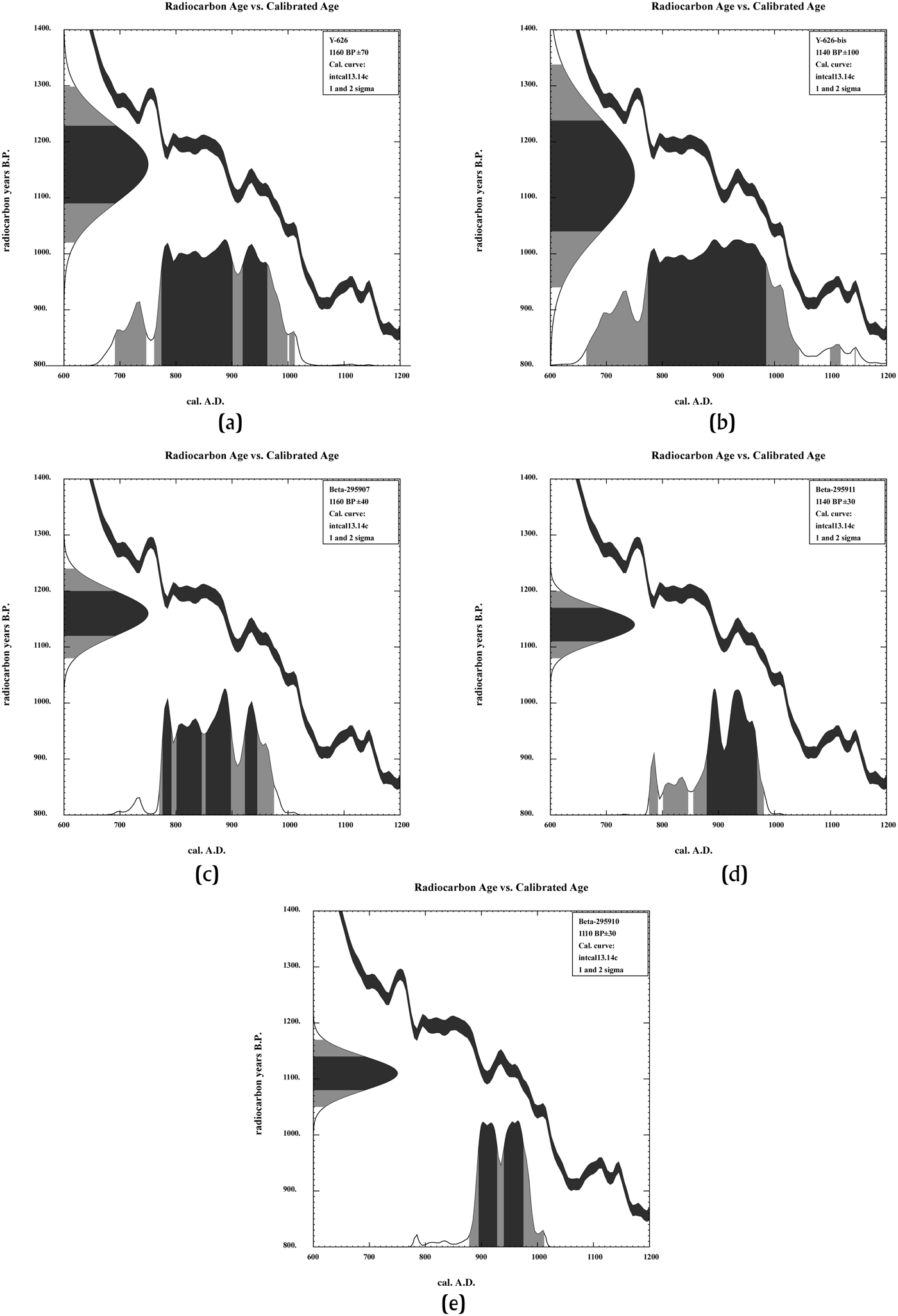
How do the hypothesized earlier construction dates agree with the radiocarbon evidence? The first radiocarbon date related to the Castillo was published in 1959 and was derived from one of the door beams from its superstructure. It yielded the date 1160±70 B.P. (sample Y-626) earlier than many would have anticipated (midpoint cal. a.d. 850) (Deevey et al. Reference Deevey, Gralenski and Hoffren1959). Due to possible instrument contamination, the sample was later rerun, yielding the date 1140±100 B.P. (sample Y-626-bis) (midpoint cal. a.d. 845), virtually identical to the first though with a greater margin of error (Stuiver et al. Reference Stuiver, Deevey and Gralenski1960).
The other early radiocarbon dates pertain to Old Chichen, so the presentation of five new radiocarbon dates by the UCSD team in their most recent paper is a welcome addition (Figure 8; Volta and Braswell Reference Volta, Braswell and Braswell2014:Table 13.2). All come from their Gran Nivelación operation, although two were judged to be outliers and were excluded from further analysis. The remaining three all belong to Construction Stage IV and were quite close in terms of uncalibrated radiocarbon years: 1160 B.P.±60, 1140 B.P.±30 and 1110 B.P.±40. The first two also replicate the lintel dates, although with narrower error ranges. Calibrated midpoints of the first two are a.d. 875 and 895 respectively, 25–50 years younger than the beam date, while the last, Specimen Beta-295910, has a midpoint of cal. a.d. 940, noteworthy as the first radiocarbon date from the tenth century. This suite of dates was then processed by means of Bayesian analysis.
Calibration curves for the radiocarbon samples from the Castillo and Gran Nivelación: (a) Y-626, from the Castillo lintel; (b) Y-626-bis, retake of (a); (c) Beta-295907, Gran Nivelación IV; (d) Beta-295911, Gran Nivelación IV; and (e) Beta-295910, Gran Nivelación IV. Raw values from Volta and Braswell (Reference Volta, Braswell and Braswell2014:Table 13.2). All samples calibrated using the CALIB 14 program, version 7.1 (Stuiver et al. Reference Stuiver, Reimer and Reimer2015). The darker curves are the one-sigma ranges, the lighter the two-sigma ranges.

Radiocarbon dates are at base probability statements concerning the confidence we may have in a postulated range of calendar years. In addition to binomially distributed measurement error, the other major source of error comes from the erratic nature of 14C production in the upper atmosphere, requiring that dates in radiocarbon years be calibrated before expressing them in calendar years. In many cases, erratic 14C production only changes the slope of the calibration curve, but in some sections of the curve, fluctuations in the levels of 14C can mean that two organisms which died at significantly different points in time may have the same 14C fraction when measured. This ambiguity cannot be resolved no matter how much measurement error is reduced.
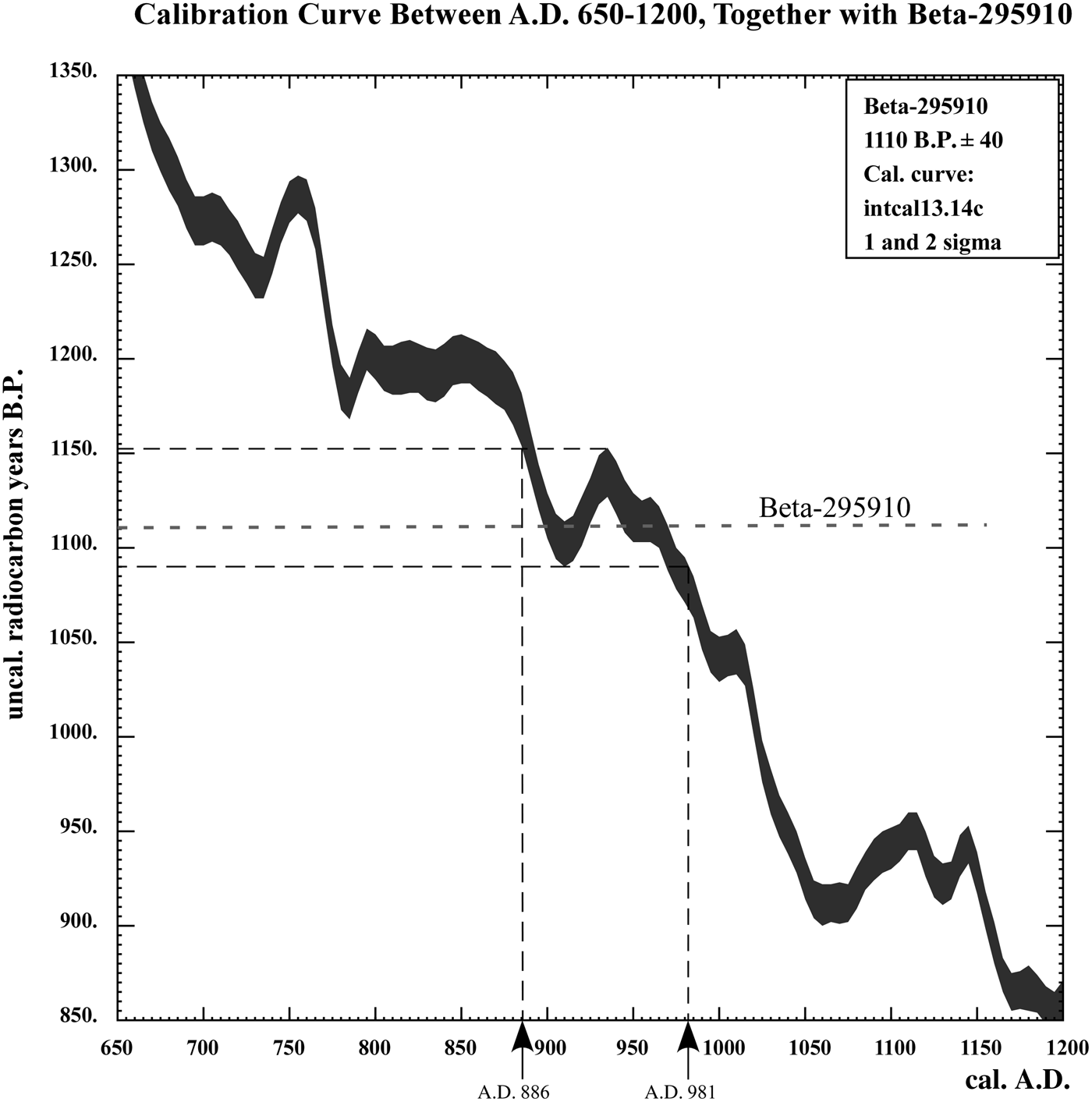
Calibration error is not binomially distributed and, when combined with measurement error, yields a complex probability curve that may have multiple peaks and be quite asymmetrical for a given range. Representing them as a calibrated mid-point and associated error range is therefore seldom satisfactory, and increasingly probability curves are provided along the calendar year axis. A good example is UCSD sample Beta-295910, the latest of their radiocarbon dates, with an uncalibrated age of 1110 B.P.±40 (Figure 9). The area about its calibrated midpoint, cal. a.d. 940, is a not particularly probable region, since it lies in the trough between the two peaks, nor is the resultant probability curve very symmetric about the midpoint.
Calibration curve, a.d. 650–1200, showing multiple calendar year intercepts for all radiocarbon values between approximately 1153–1090 B.P. (data from Oxford Radiocarbon Accelerator Unit [OxCal 2015]). Superimposed is a line representing the mean value of UCSD Radiocarbon sample Beta-295910 (1110 B.P.), excluding measurement error.

Closer inspection reveals that the corresponding section of the calibration curve has a pronounced oscillation in this region, created by a major dip bottoming out around 1090 B.P. (cal. a.d. 910) (Figure 9). As a result, all radiocarbon dates between about 1153–1090 B.P. (cal. a.d. 886–981) have multiple intercepts with the calibration curve, most often three and in a few cases more. After a.d. 981, single intercepts resume. (When measurement error is included, the effect of the “hump” extends over a considerably broader span, and may include neighboring humps or plateaus). In the case of dates with three intercepts, two will come from the later “hump,” and the probability graph will necessarily be skewed toward higher calibration values, no matter what the actual date of the sample. In the case of Beta-295910 (Figure 8e), the two one-sigma peaks extend between cal. a.d. 895–928 (p = 0.486) and cal. a.d. 940–975 (p = 0.514), whereas the first intercept is somewhat before a.d. 900. In short, radiocarbon dates will be of little assistance in resolving events falling between a.d. 890–970, which is, of course, precisely the focal point of the debate.
Nevertheless, placement of the Beta-295910 date in the later one-sigma peak seems problematic because stratigraphically it comes from four construction stages prior to the Castillo (IV vs. VIII, following the UCSD schema), or one or two in the revision advanced above. If the Castillo does indeed antedate the a.d. 998 date from the Osario, as seems likely, choosing the later calibration date for its lintel would compress the time between the two to a matter of a few decades, if that, especially if the lintel was not freshly felled for Construction Stage IV.
A final implication of the revised stratigraphy is that the Castillo-sub (in Stage III) would antedate the radiocarbon dates from Stage IV, thus dating its construction most probably to the mid-or-latter half of the ninth century, as might be expected from its architectural style, and contemporary with the Pure Florescent structures of Old Chichen. It would also indicate that the Gran Nivelación began functioning as a public or ceremonial space at the same time that the Pure Florescent structures in the vicinity of Las Monjas served the civic needs of the city, and would sustain our contention that “Toltec” traits were adopted gradually and piecemeal by a local elite (Bey and Ringle Reference Bey, Ringle, Kowalski and Kristan-Graham2007; Ringle and Bey Reference Ringle, Bey, Fash and Leonardo2009).
Bayesian Processing
This also has repercussions for the next stage of their analysis, a Bayesian analysis of the dates and stratigraphic contexts. Bayesian analysis attempts to firm up the probabilities of dates by specifying adherence to other information, such as architectural superpositions, stratigraphy, or even other dates. In this case the dates were broken into groups with the Castillo group (represented only by the wooden lintel) required to postdate the three new dates from the Gran Nivelación (Volta and Braswell Reference Volta, Braswell and Braswell2014:381). The two 14C dates from the Castillo lintel were pooled prior to this analysis. The dates from the Gran Nivelación were not much affected, yielding mid-points of around cal. a.d. 870–880, but the “dramatically improved date” of the pooled lintel sample now yielded a midpoint of cal. a.d. 965, considerably higher than the midpoints of the original dates and significantly higher (by 83 years) than what I calculated to be a pooled mean of around cal. a.d. 882. As the probability plots of the original date shows (Figures 8a and 8b), the new range is nearly beyond the one-sigma range of the original lintel sample (Volta and Braswell Reference Volta, Braswell and Braswell2014:382).
In my view, rather than confirming a late date for the Castillo, this indicates that the Castillo is misplaced stratigraphically, leading to a forcing of the date into the later tenth century. Furthermore, although it may be true that the Castillo postdates the Gran Nivelación radiocarbon dates, the lintel may well not have, since Volta and Braswell (Reference Volta, Braswell and Braswell2014:382) argue that some beams may “date to a time 70–150 years before their hieroglyphic texts were carved.” In this regard, it may be significant that two of the UCSD Stage 4 radiocarbon dates (Beta-295907 and Beta-295911) replicate, in radiocarbon years B.P., the two dates extracted from the beam of the Castillo (Y-626 and Y-626-bis, respectively). Although the ranges of the UCSD dates are considerably narrower, the overlaps may indicate that the beam (or at least that portion that was sampled) was contemporary with Stage IV and that the Castillo was raised at some unknown later date. Alternatively, if the beam was freshly felled near to the time that the Castillo was built, it would indicate relatively little time elapsed between Construction Stage IV and construction of the Castillo, as my placement in Stage V hypothesizes.
In short, radiocarbon dates offer little support for the authors’ contention that “much of the International-style architecture visible at Chichen Itza was built after a.d. 950 and especially around a.d. 1000” (Volta and Braswell Reference Volta, Braswell and Braswell2014:383). Architectural seriation suggests, instead, that the Castillo, Temple of the Chac Mool, Big Tables, and I would argue, the Great Ballcourt all antedate the Osario, and the Temple of the Warriors was its near contemporary.
The Argument for a Hiatus
Although moving the chronology of Modified Florescent Chichen Itza forward a half-century is not of momentous importance (most authorities, including the author, accept a full “Toltec” occupancy throughout some, if not all, of the first half of the eleventh century), the UCSD team further argues for a possible mid-tenth century hiatus and abandonment of the site on the wobbly back of the single pooled and heavily massaged date from the Castillo lintel. This break is hypothesized to separate Pure Florescent and early transitional buildings from later Sotuta structures. The argument is a curious one:
[t]he picture that is emerging now is that the early tenth century represents a significant decline or slowdown in construction activity after the Maya style of the late ninth century and before the full International style of the late tenth century. Thus, Transitional-style architecture is dated to this period of reduced construction, and the greatest building in this style—the Castillo-sub—probably was constructed towards its end. Moreover, except for a possible date of a.d. 930 from the Caracol round stone, there is no evidence for writing during the interval a.d. 897–998. If both the seeming architectural lull and the hieroglyphic pause are real—and if it can be shown that there is little pottery dating to this period—then a strong argument could be made that Chichen Itza suffered a decline or even a hiatus during the early tenth century (Volta and Braswell Reference Volta, Braswell and Braswell2014:388).
To argue for a mid-ninth century hiatus on the basis of a lack of hieroglyphic dates seems circular, since, of course, a hallmark of New Chichen is the absence of Maya dates. By the same logic, there is no evidence for occupation after a.d. 998. Demonstrating a lack of pottery from the period also depends on circular argumentation, as the only means of dating pottery are either hieroglyphic dates or radiocarbon dates from associated materials, since they posit no grounds for subdividing the Sotuta phase. A final objection stems from Volta and Braswell's acceptance of the High Priest's Grave/Osario as a later building and the Castillo as relatively early in the sequence. Moving the inception of Sotuta pottery and International architecture forward in time crowds all the construction activity and changes in design to just a few decades.
In our view, this transition was swift, but it was continuous, as can be seen in those structures usually identified as transitional. The best example is the contrast between the Pure Florescent architecture of the Castillo-sub and the furniture and offerings from its temple, which are virtually identical to Modified Florescent examples. The turquoise mosaic disk found on the jaguar throne, for instance, replicates those found in caches from the Temple of the Chac Mool and the dedication of the final Castillo. These argue for the evolution of “Toltec” practices within an earlier architectural framework and their continuity into the succeeding Modified Florescent stage. Another interesting example is the Temple of the Big Tables-sub, which has the vertical lower wall of Pure Florescent architecture (Schmidt Reference Schmidt, Kowalski and Kristan-Graham2007:194–195). Nevertheless, its piers were painted with warriors costumed in archetypal “Toltec” fashion, yet whose facial features more closely resemble lowland Maya portraiture (Schmidt Reference Schmidt, Kowalski and Kristan-Graham2007:Figure 8).
Another argument for continuity is the placement of mosaic (“Chak”) masks on both Pure and Modified Florescent structures. It is not surprising that structures such as Las Monjas, the House of the Three Lintels, the House of the Deer, and other Pure Florescent structures should have such masks, but they also adorn the Caracol, the Temple of the Warriors, the Osario, and the Castillo in highly visible positions. (As noted, however, contrasting sets of decorative details allow Pure and Modified Florescent to be categorized quite easily).
The best evidence, however, comes from several Pure Florescent elite compounds which were modified in very specific ways to accommodate the new political order, in our view indicating continuity of occupation (Ringle and Bey Reference Ringle, Bey, Fash and Leonardo2009). Morley (Reference Morley1931:636) recognized as early as 1931 that so-called Maya structures, such as the Casa Colorada and the Temple of the Four Lintels, had been modified by the addition of Modified Florescent roof elements (merlons), leading him to conclude: “[i]t is therefore unnecessary to assume that all Period II buildings were abandoned in Period III; almost certainly such was not the case.” (Period II corresponds to Pure Florescent in Carnegie terminology). In our view, such modifications resulted from the incorporation of non-royal elites as the administrators and military chiefs of this new political order. By virtue of their incorporation into this arrangement, they peopled the ranks of the “Toltecs” depicted in the reliefs and paintings of New Chichen.
Cobos Palma (Reference Cobos Palma, Sanders, Mastache and Cobean2003a) noted how late Modified Florescent elite compounds often contained a temple, sometimes with serpent columns, a gallery-patio structure, a radial altar, a ballcourt, and a columned hall, though not always with the full complement. Exactly these elements were also added to existing Pure Florescent compounds, such as the Group of the Initial Series, but earlier buildings continued to be used and modified. The Group of the Initial Series is probably the most thoroughly investigated, and here a temple, gallery-patio, and columned hall were built, as well as an altar in the form of a turtle (Schmidt Reference Schmidt, Kowalski and Kristan-Graham2007). A court was also added to the Pure Florescent House of the Phalli, and the piers of the court were decorated with Modified Florescent warriors, like much of central Chichen. In our view, elite compounds were transformed into the headquarters for warrior sodalities or battalions under the leadership of the noble family residing on these platforms. The Grupo Ho’ Che and the Grupo Suroeste are other good examples; the last, in fact, may have lodged two such groups (Lincoln Reference Lincoln1990, Ruppert Reference Ruppert1952).
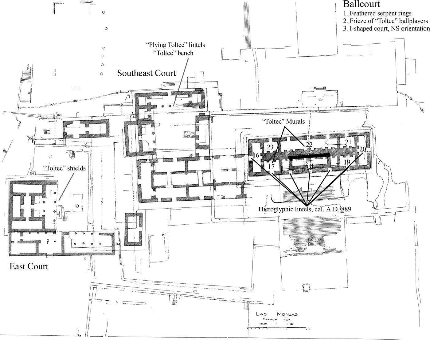
This same transformation swept what many regard as the regal administrative core of Old Chichen, the Monjas-Caracol-Casa Colorada complex of platforms. Las Monjas (Bolles Reference Bolles1977) is commonly regarded as the most important structure of Old Chichen and has seven of its second-story doorways capped with hieroglyphic lintels dating to a.d. 880 (Figure 10). A jaguar throne found at the base of the front staircase also marks its prominence. This may either have been placed there during the late ninth century, when the hieroglyphic lintels were installed and perhaps at the same time the jaguar throne was installed in the Castillo-sub, or perhaps was a later placement to mark its continued importance during the Modified Florescent period, as does the mural fragment of a jaguar throne from the Temple of the Warriors (Morris et al. Reference Morris, Charlot and Morris1931:vol. II, Plate 151). The inscription over the central doorway of the East Wing is another example of Central Mexican traits antedating the Modified Florescent period (Bricker and Bricker Reference Bricker and Bricker1995). Bricker and Bricker (Reference Bricker and Bricker1995) argue that this commemorates several astronomical observations that can be dated to a.d. 877, contemporary with the hieroglyphic lintels, but yet are couched in a mixture of Maya and highland conventions.
Plan of Las Monjas showing modifications made during the Modified Florescent stage. Map drawn by the author (after Bolles Reference Bolles1977).

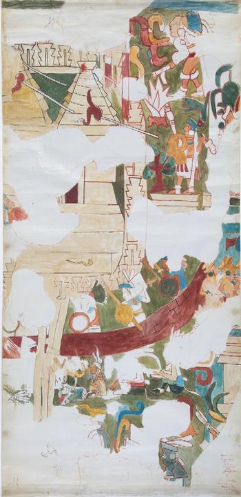
Undeniable evidence of the Modified Florescent modification and use of the structures include traces of murals in the same story with the hieroglyphic lintels (Figure 11). Those in two of the rear rooms, Rooms 17 and 22, strongly resemble murals from the Upper Temple of the Jaguars. Similarities include details such as the merlons on the defensive wall and speech scrolls uttered by some of the participants, to the overall composition, which depicts a pitched battle scene with many figures and buildings (some with Modified Florescent profiles), virtually unknown outside the late Chichen murals. Figures wearing the aztaxelli hair ornament and carrying atlatls, darts, and shields also occur on some of the mural fragments (Bolles Reference Bolles1977:204–205).
Mural fragment from the interior of Room 22, Las Monjas. Illustration by Adela Breton, Bristol Museum, http://museums.bristol.gov.uk/details.php?irn=219229.

The compound was enlarged by enclosing the East and Southeast Courts with Modified Florescent structures, as indicated by their battered lower wall zones. These, I submit, were the equivalent of the court added to the rear of the House of the Phalli in the Initial Series Group. Although these had columns instead of warrior columns; the military element is represented by a series of shields found in the collapse of the East Building of the East Court. Some of the devices on the shields are also those of warriors in the UTJ murals, others clearly belong to the Modified Florescent horizon. In the Southeast Court, the jambs and column capitals of the South Building were decorated with figures in “Toltec” garb, and a bench appears to have been decorated with a procession of “Toltec” warriors leading figures attached to them by ropes. (The two figures from the capitals are reclining warriors reminiscent of the Temple of the Warriors and the Burned Palace at Tula). A ballcourt was also built at the rear of Las Monjas. Although the latter was not firmly tied into the construction sequence of Las Monjas, there can be no doubt that it belongs to the Modified Florescent horizon. Although only the lower portions of most of the figures lining the bench have survived, it is clear that they wore much the same costume as on the Great Ballcourt reliefs. A feathered serpent ball court marker confirms the placement of the ballcourt (Bolles Reference Bolles1977:228–229).
The Casa Colorada group also was modified by the addition of a colonnaded hall and a ballcourt with the enclosed end zone and north-south orientation typical of Modified Florescent Chichen ballcourts. Furthermore, the conventions of the reliefs decorating the lower ballcourt bench edge are very similar to those of the Great Ballcourt. Perhaps the Temple of the Wall Panels, wholly Modified Florescent in construction, was added to the complex of structures comprising Old Chichen at this time.
CLIMATOLOGICAL ARUGMENTS
Recently, two studies have applied climatological records to the chronology of Chichen Itza (Cobos Palma et al. Reference Cobos Palma, Anda Alanís and García Moll2014; Hoggarth et al. Reference Hoggarth, Breitenbach, Culleton, Ebert, Masson and Kennett2016). Both generally support the chronology advocated in this paper but, because both are more concerned with the collapse of Chichen, and, thus, treat its chronology in broad strokes, they will not be discussed in detail. Climatological records do present additional interpretive challenges, however, the first being the resolution, calibration, and agreement between the several studies now available. Hoggarth et al.’s (Reference Hoggarth, Breitenbach, Culleton, Ebert, Masson and Kennett2016) Figure 2 illustrates the variations in resolution, timing, and amplitude between the oscillations of five paleoclimatic studies, such that almost any scenario can find support in one of them. Regarding the non-speleothem studies, Hoggarth et al. (Reference Hoggarth, Breitenbach, Culleton, Ebert, Masson and Kennett2016:30) admit that “[t]he broad time span of these climatic changes is not precise enough to allow for clear chronological associations between drought and the breakdown of political and social systems across the region to be identified.” Another consideration is whether these records represent peninsula-wide patterns or are more local in effect. Cobos Palma et al. (Reference Cobos Palma, Anda Alanís and García Moll2014) base their discussion on a study (Medina-Elizalde et al. Reference Medina-Elizalde, Burns, Lea, Asmerom, von Gunten, Polyak, Vuille and Karmalkar2010) of a speleothem from Tzabnah Cave, near Tecoh, Yucatan, and about 95 kilometers west of Chichen Itza. In contrast, Hoggarth et al. (Reference Hoggarth, Breitenbach, Culleton, Ebert, Masson and Kennett2016) rely upon the much more distant speleothem record of Yok Balum in southern Belize. The latter authors point to the lack of correlation between historically known droughts and the Tzabnah record as an important reason for favoring Yok Bahlum, despite its much greater remove, yet the Yok Balum record indicates severe conditions throughout much of the ninth century, when Chichen Itza began its dramatic rise to power.
Another problem is that normally climatic events are only correlated with the archaeological record, rather than being tied directly to archaeological features and deposits. Cobos Palma et al. (Reference Cobos Palma, Anda Alanís and García Moll2014) attempt to do just that by discussing a now-inundated deposit of Sotuta pottery placed on a ledge inside a cenote during a period when the water table was from one to five meters lower than today. This they argue happened when “Chichen Itza was a functioning city and the most important political unit of central Yucatan” (Cobos Palma et al. Reference Cobos Palma, Anda Alanís and García Moll2014:64). The difficulty is that not only is it argued that this deposit was exposed at a time of prosperity, following and concurrent with postulated droughts from the Tzabnah speleothem, but also that “the interpretation of the archaeological record suggests that these episodes were part of a gradual process that reached its peak in the eleventh century” (Cobos Palma et al. Reference Cobos Palma, Anda Alanís and García Moll2014:65). The reasons for this lag of a century and a half between the onset of droughts and the final abandonment of Chichen Itza, perhaps as late as a.d. 1100 according to Cobos Palma et al. (Reference Cobos Palma, Anda Alanís and García Moll2014), are left unspecified and, again, practically any scenario could be accommodated. This is especially puzzling since the Tzabnah sequence shows a.d. 950–1100 to be a period of above-average precipitation.
In addition to providing proxies for rainfall, speleothem studies offer the promise of an extremely fine-grained chronology that may be able to sidestep the calibration issues of radiocarbon dating. As more examples accumulate from across the peninsula, we can expect improvement in defining the severity and regional extent of climatic stress episodes. The challenge will be to tie these to the archaeological record and to provide better models of how the northern cities reacted to climatic stress.
CONCLUSION
In this paper, I have attempted to show that present archaeological evidence is consistent with a tenth century florescence for Modified Florescent Chichen Itza. We have considerable evidence for the local adoption of the new political ideology during the latter ninth century, and, in my opinion, none for a tenth-century hiatus or abandonment. The Osario is unlikely to have been the last public structure, and construction may well have continued into the eleventh century, but at present no solid evidence places any major construction after a.d. 1000. For the twelfth century, we have nothing whatsoever except (possibly) scattered renovations by a population clearly on the decline.
Difficulties remain to be explained. As Andrews V (Reference Andrews, Wyllys and Mills1979) and Andrews (Reference Andrews1995) have pointed out, the Pure Florescent architecture of the Puuc is significantly different from that at Chichen Itza, both in technique and style. Although Chichen Itza might be supposed the innovator, architecturally that seems doubtful, since, technically, Modified Florescent architecture at Chichen seems most like the masonry of the Palace of the Governor and the Nunnery of Uxmal, currently dated to around a.d. 900. Current chronologies suggest a significant lag in the uptake of the Pure and Modified Florescent styles at Chichen Itza, just one aspect of the broader question of the direction of influence between the two regions. Although the non-Maya ramifications of Chichen's chronology are too broad to be addressed here, the question of Tula also continues to be a quandary. New discoveries in Tula Chico (Healan Reference Healan2012; Jiménez García Reference Jiménez García2008; Mastache et al. Reference Mastache, Cobean and Healan2002:73–76, Reference Mastache, Healan, Cobean, Fash and Luján2009) push back the onset of Toltec motifs there a century or so, into the Epiclassic, but it is difficult to understand how what was then a relatively small site could have exerted much sway over the distant city of Chichen Itza.
Clearly, much of the iconography, certain valuables, and even minor changes in foodways came to Chichen Itza from beyond the Maya realm, but the basic armature of everyday life is that of northern Yucatan. Foreign dynasts may have been imported, as we know happened elsewhere, and external visitors may have been present, but a population replacement, much less the advent of Topiltzin Quetzalcoatl, is no more tenable today than it was forty years ago (contra Coe and Houston Reference Coe and Houston2015:201–207). At present, it seems best to see these changes as mediated by Yucatecans, and in this local mediation of “Toltec” ideology, Chichen Itza was no different than many of the other Tollans which arose in Mesoamerica.
RESUMEN
Siguiendo una tendencia académica de favorecer fechas cada vez más tempranas para datar la ocupación de Chichén Itzá, el reciente trabajo de campo realizado por equipos del Instituto Nacional de Antropología e Historia (INAH), la Universidad Autónoma de Yucatán (UADY), y la Universidad de California, San Diego (UCSD), ha aportado una nueva cronología del sitio que mueve la llamada ocupación tolteca o Floresciente Modificado más cerca de la hipótesis de antes de la década de 1970, c. 950–1150 d.C. Este artículo presenta una crítica de las bases (cerámica, radiocarbono y estratigrafía) de su propuesta, argumentando que en cambio, la presente evidencia indica que Chichén Itzá experimentó un florecimiento en el siglo décimo. Aunque el sitio pudo continuar estando ocupado en el siglo siguiente, hasta ahora no tenemos fechas absolutas después del año 1000 y no existen evidencias de construcción monumental tardía. Por otro lado, los argumentos de un propuesto hiato o discontinuidad al inicio del periodo tolteca son rechazados en favor de un modelo de desarrollo continuo de ideas toltecas desde finales del siglo IX en adelante.
ACKNOWLEDGMENTS
Thanks to Mat Saunders for an invitation to present a preliminary version of this paper at the Maya at the Playa meeting in September 2015, and to colleagues George Bey and Chris Gunn for comments on the ceramics. I am also grateful for conversations with Bruce Love, Geoff Braswell, Will Andrews, Tony Andrews, and Tomás Gallareta Negrón, who also translated the summary. Rach Cobos and an anonymous reviewer made useful comments on the initial submission of this paper.