INTRODUCTION
Scholarly research on Postclassic central Mexican society has privileged the study of the Late Postclassic (a.d. 1350–1519) period, particularly the Aztec imperial transition. This focus is at least partly due to our dependence on colonial documents in the construction of chronological frameworks and the identification of political and economic transitions of interest (Morehart Reference Morehart2012; Overholtzer Reference Overholtzer2013). The descendants of Aztec nobility who authored these colonial documents often highlighted Aztec imperial actions and the events that led up to the formation of the Aztec Triple Alliance. Thus, archaeologists have tended to investigate events of imperial consequence, and other, significant sociopolitical transitions that are not prominently featured in the historical record have received less scholarly attention. However, archaeological research at the site of Xaltocan, Mexico, by Elizabeth Brumfiel and her students has played a crucial role in expanding our understanding of the period that came before the rise of the Aztec empire. Xaltocan, the capital of the pre-Aztec Otomi city-state, was a powerful regional center during the Early and Middle Postclassic periods (a.d. 900–1350). Here, we build upon Brumfiel's work to examine a striking transition at Xaltocan that took place around a.d. 1240, and which was largely ignored by Aztec imperial accounts. Archaeologists have previously associated this period with the shift from Aztec I to Aztec II Black-on-Orange pottery. In this paper, however, we demonstrate that this transition was also associated with a larger suite of material changes that have not been previously documented (see also De Lucia and Overholtzer Reference De Lucia and Overholtzer2014).
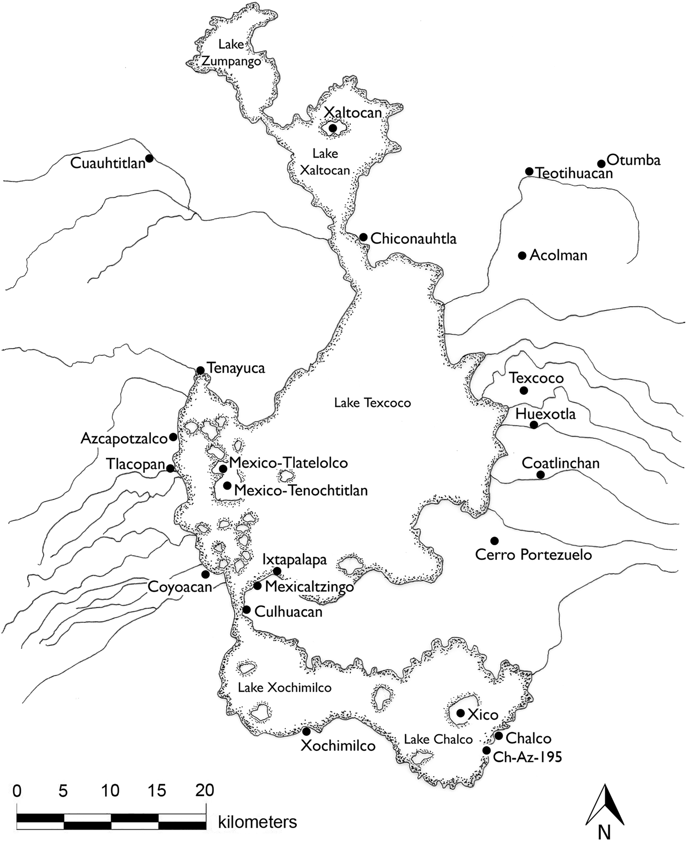
The transition of interest here took place in the Middle Postclassic (a.d. 1150–1350) period, centuries before the formation of the Aztec Triple Alliance and during a period of endemic warfare, as dozens of small central Mexican city-states vied for political and economic control. This period remains poorly understood archaeologically. As Jeffrey Parsons and colleagues (Parsons et al. Reference Parsons, Brumfiel and Hodge1996:228) noted, archaeologists still do not comprehend the basic spatial and temporal distributions of diagnostic pottery wares, such as Aztec I and Aztec II Black-on-Orange pottery, much less their social, political, and economic implications. Aztec II occupation is especially poorly understood, as no Middle Postclassic sites were identified in the Zumpango area survey aside from Xaltocan (Parsons Reference Parsons2008), it was not systematically recorded in the Temascalapa regional survey (Gorenflo et al. Reference Gorenflo, Sanders and Robertson2007), and it was likely misinterpreted as entirely contemporaneous with Aztec I in the southern basin surveys (Parsons et al. Reference Parsons, Brumfiel, Parsons and Wilson1982). Scholars have, however, come to appreciate the dynamic nature and spatiotemporal complexity of occupation during this period. Recent extensive excavations at Xaltocan, one of the most important sites in the Basin of Mexico at this time, (Figure 1) offer significant insight into demographic and social processes during this neglected period. Archaeologically evident changes at Xaltocan during the Middle Postclassic period include the expansion of the island, a dramatic population increase, and the rise of two subpopulations with distinct consumption patterns, household spatial norms, and funerary practices (De Lucia and Overholtzer Reference De Lucia and Overholtzer2014).
Map of the Basin of Mexico.

In this paper, we consider the causes of such shifts using a multi-scalar approach, linking understandings of macrolevel population dynamics, ethnic politics, and political-economic processes with microlevel changes in domestic practice. This transition was likely consequential for the rise of the Aztec empire, and our findings regarding changes in social organization and household ritual practice have important implications for shifting conceptions of identity associated with the emergence of large polities. However, it is also vital to understand shifts such as these on their own, and not solely in relation to the emergence of the Aztec empire, since the pre-Aztec transition we discuss here is more visible in the archaeological record and thus likely would have been more acutely felt by residents than the later Aztec imperial transition. We must not let later Aztec histories overshadow earlier historical events, as local Xaltocan historian Omar Romero Navarrete (Reference Romero Navarrete2007:12) explains has happened: “the history of Xaltocan became the history of Tenochtitlan … and that noble history, Xaltocan's beautiful history, was erased and replaced by the Mexica and Tenochtitlan.” Here we recuperate some of that pre-Aztec history by examining processes of change during the rise and height of the Xaltocan polity.
THE POSTCLASSIC BASIN OF MEXICO
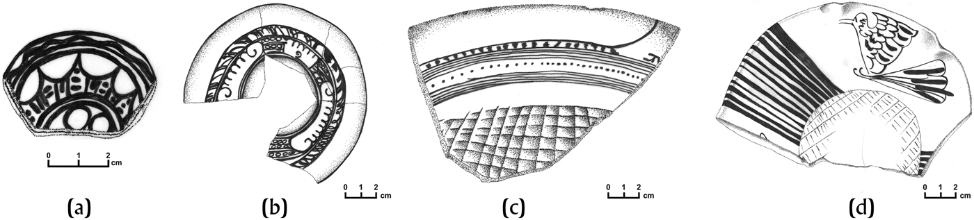
The Basin of Mexico survey project directed by William Sanders, Jeffrey Parsons, and colleagues (Blanton and Parsons Reference Blanton, Parsons and Parsons1971; Parsons Reference Parsons1966; Sanders et al. Reference Sanders, Parsons and Santley1979; Whalen and Parsons Reference Whalen, Parsons, Parsons, Brumfiel, Parsons and Wilson1982) in the 1960s and 1970s first characterized the geographical and chronological distribution of settlement in central Mexico. They built on George Vailliant's (Reference Vaillant1938) comprehensive Basin of Mexico ceramic seriation, which outlined a transition in the Epiclassic period from the Coyotlatelco tradition to Mazapan wares, followed by a four-period Postclassic chronology based on the successive Aztec I-IV Black-on-Orange diagnostic wares of relevance to this paper (Figure 2). Aztec I pottery (Figure 2a) is characterized by figurative designs such as flowers painted in thick lines, and vessels often have stamped bases. Aztec II pottery (Figure 2b) features stylized and geometric designs in lines of medium-thickness, and often features the “zacate” or grass motif. The Aztec III ware (Figure 2c) has simpler geometric designs, especially parallel lines, dashes, and dots, painted in very fine lines. Both thin parallel lines, dashes, and dots and very thick lines appear on Aztec IV pottery (Figure 2d), and some variants have naturalistic motifs.
Diagnostic Aztec Black-on-Orange wares: (a) Aztec I; (b) Aztec II; (c) Aztec III; (d) Aztec IV.
The work of Sanders, Parsons, and colleagues suggested that this commonly held chronological sequence was too simple, and that there was a significant amount of chronological overlap and variation from region to region; more recent excavation projects (Evans and Freter Reference Evans and Freter1996; Parsons et al. Reference Parsons, Brumfiel and Hodge1996) have confirmed this spatiotemporal complexity. For example, Parsons, Elizabeth Brumfiel, and Mary Hodge (Reference Parsons, Brumfiel and Hodge1996), showed that Teotihuacan residents adopted Coyotlatelco ceramics to their household assemblages significantly later than sites in the southern Basin of Mexico. In addition, Aztec I pottery was used at Xaltocan as early as the tenth century, while at Chalco, Coyotlatelco and Mazapan pottery continued in use. Within the Basin of Mexico, Aztec I-II and Mazapan appear to be somewhat contemporaneous, spatially separate complexes. These authors suggest that cultural changes after the fall of Teotihuacan and before the rise of the Aztec empire that are seen in ceramic consumption practices have their roots in sociopolitical factors. In particular, they “suspect that this change included a complex series of interactions between different ethnic and sociopolitical groups that explicitly reinforced and symbolized their identities through the use of distinctive ceramic assemblages” (Parsons et al. Reference Parsons, Brumfiel and Hodge1996:228).
The spatial and temporal distributions of Aztec I and II ceramics are of most interest to us here. The survey project of Sanders, Parsons, and colleagues revealed that Aztec I pottery was largely confined to the southeastern basin, with the notable exception of the island of Xaltocan in the north (Figure 3), while Aztec II was found throughout the Basin (Figure 4). Note, however, that their surveys did not include much of the western basin, so we lack information for the distribution of these wares there. To understand the chronological relationship between Aztec I and Aztec II complexes, Parsons et al. (Reference Parsons, Brumfiel and Hodge1996) compared radiocarbon dates associated with Aztec I, mixed Aztec I and II, or Aztec II deposits from test pits at Xaltocan, Chalco, and Ch-Az-195, the latter a small hamlet with almost exclusively Aztec I occupation (Figure 1). These sites were chosen for their deep, relatively undisturbed deposits and the presence of Aztec I pottery. At Chalco, Aztec I pottery appears to have been used between approximately a.d. 1000 and some time in the thirteenth century, after which both Aztec I and Aztec II wares were used. Interestingly, Aztec I ceramics were locally produced, while Aztec II and later Aztec III wares were all imported, suggesting an intrusive, rather than locally developed, tradition. Aztec I occupation at Ch-Az-195 appears to span the eleventh through fourteenth centuries. That is, residents of Ch-Az-195 continued to use Aztec I pottery while Chalco residents used both Aztec I and Aztec II wares. The association of Aztec I ceramics with radiocarbon dates as early as the ninth century and as late as the fourteenth century suggests that in some parts of the basin, Aztec I ceramics may have been used over a very long period of time. Parsons and colleagues (Reference Parsons, Brumfiel and Hodge1996:227) suggest that these data “may indicate a long period of overlap between Aztec I and Aztec II in the Basin of Mexico and/or a long delay in the spread of Aztec II pottery into the southeastern Basin.”
Distribution of Aztec I pottery in the Basin of Mexico.
Distribution of Aztec II pottery in the Basin of Mexico.
This paper sheds further light on this topic by drawing on recent excavations of firmly dated, stratified household contexts at Xaltocan, where both Aztec I and Aztec II pottery were used. This contribution thus carries on the work of Elizabeth Brumfiel, who was the first to undertake systematic research at Xaltocan to understand temporal shifts over the course of the Postclassic period and the first to conduct household excavations designed to clarify Aztec I occupation in the Basin of Mexico, and to whom this special issue is dedicated.
ARCHAEOLOGICAL RESEARCH AT XALTOCAN
Brumfiel was originally drawn to Xaltocan because of the site's continuous occupation from the Early Postclassic to modern day, spanning multiple political and economic transitions. According to ethnohistoric documents, Xaltocan was founded by Otomi-speaking peoples and quickly rose to be the capital of the expansive Otomi city-state (Alva Ixtlilxóchitl Reference Alva Ixtlilxóchitl and O'Gorman1975–1977: I:423, II:299; Carrasco Reference Carrasco1950; Gibson Reference Gibson1964:10). By the mid-thirteenth century, Xaltocan was at war with neighboring Cuauhtitlan, part of the rising Tepanec city-state, and in 1395, was defeated (Bierhorst Reference Bierhorst1992:54–61). All of Xaltocan's inhabitants reportedly fled to Meztitlan, Tlaxcala, Acolhuacan, and other sites (Alva Ixtlilxóchitl Reference Alva Ixtlilxóchitl and O'Gorman1975–1977, II:36), and ancient DNA analyses have confirmed a significant demographic event at this time (Mata-Míguez et al. Reference Mata-Míguez, Overholtzer, Alegría, Kemp and Bolnick2012), though recent archaeological investigations (Overholtzer Reference Overholtzer2013) have cast doubt on the extent of this exodus. The Tepanecs were defeated in a.d. 1428, and the Aztec Triple Alliance subsequently formed. Xaltocan's lands then became part of the expansive state known as the Aztec Empire. In 1435, the Aztec ruler is said to have resettled Xaltocan with a multiethnic taxpaying population from around the Basin of Mexico (Bierhorst Reference Bierhorst1992:76, 104). In 1521, Xaltocan was conquered and burned by Cortés’ army (Díaz del Castillo Reference Díaz del Castillo and Maudslay1956:355–357), but Xaltocan's residents persevered and some even thrived in the Colonial period after intensifying productive activities that exploited their lacustrine setting (Gibson Reference Gibson1964; Rodríguez-Alegría Reference Rodríguez-Alegría2010). Xaltocan archaeological deposits thus span the site's founding, rise to power, war-plagued height, conquest, imperial domination, and colonial rule.
Archaeological work to investigate these political and economic transitions began at Xaltocan in 1987 with an intensive survey project (Brumfiel Reference Brumfiel2005:35–41), and work at the site by Brumfiel's former students is ongoing. The site was mapped, and visible mounds—most of which were low-lying and formed as a result of continuous household construction and occupation—were given structure numbers (e.g., Structure 122). Two-by-two meter test pits were subsequently placed on a sample of 19 of these mounds; these test pits and all subsequent excavations were called Operations (Ops).
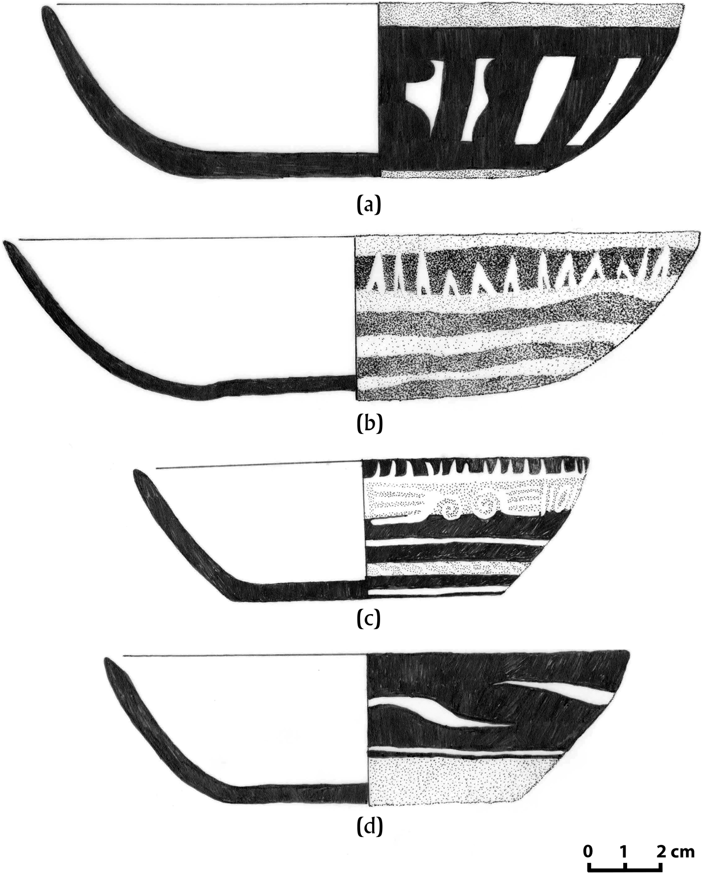
Using stratigraphy, ten radiocarbon determinations, multi-dimensional scaling of ceramic assemblages, and identification of ceramic variants across the phases, Brumfiel created a four-phase site chronology (Brumfiel Reference Brumfiel2005). Early Postclassic Phase 1 was defined by the exclusive use of Aztec I Black-on-Orange pottery alongside Chalco Polychromes, and was associated with radiocarbon dates with medians of a.d. 880 to 990. Early-Middle Postclassic Phase 2 was defined by Aztec I and II Black-on-Orange wares, Chalco Polychrome, and small quantities of Plain Redware, Black-on-Red, and Black-and-White-on-Red. In particular, high frequencies of Brown Incised ware (Figure 5) and the presence of an incised Black-on-Red variant with a cane motif served as excellent markers for the phase. Phase 2 was associated with radiocarbon dates with medians of a.d. 1235 and 1300. Middle Postclassic Phase 3 was defined by the exclusive use of Aztec II Black-on-Orange pottery alongside Brown Incised, Huastec Tradewares, Aztec Polychrome, and Redwares. Diverse Black-and-White-on-Red wares featuring horizontally, vertically, or diagonally organized motifs are particularly abundant during this period, as are both Black-and-White-on-Red and Black-on-Red with a black band at or right below the rim (Figure 6). Phase 3 was associated with radiocarbon dates with medians of a.d. 1395 and 1425. Brumfiel also noted a temporal trend within the two variants of Aztec II Black-on-Orange: the Calligraphic variant was more common than the Geometric variant in Phase 2, accounting for 81 percent of Aztec II sherds, while in Phase 3, the Calligraphic and Geometric variants were equally common. Finally, Late Postclassic-early colonial Phase 4 was defined by the use of Aztec III and IV Black-on-Orange wares, Huastec Tradeware, Plain Redware, Black-on-Red, and lower quantities of Black-and-White-on-Red, and was associated with a single radiocarbon date with a median of a.d. 1415. Unfortunately, her chronology was anchored in time by few dates, and Phases 3 and 4 were not separated in absolute time in the radiocarbon determinations. Moreover, the Xaltocan dates did not correspond well with findings from other sites. For example, refined chronologies for sites in Morelos revealed that Aztec III Black-on-Orange appeared by the early to mid-fourteenth century (Hare and Smith Reference Hare and Smith1996; Smith and Doershuk Reference Smith and Doershuk1991); presumably, the ware would have been somewhat widespread within the basin, including sites such as Xaltocan, before it was exported elsewhere.
Brown Incised Ware, common in Phase 2 deposits.
Common Phase 3 Black-and-White-on-Red wares: (a) Vertically oriented motif with black band below rim; (b) Horizontally organized motif with black band below rim; (c) Horizontally oriented motif with black band at rim; (d) Diagonal motif with black band at rim.
Subsequent extensive household excavations by Brumfiel and the authors (Figure 7) have provided the opportunity to revisit this chronology and examine changes in ceramic consumption practices across the entire occupational history of the site. In 1997 and 1999 Brumfiel exposed a large portion of a multiroom house compound likely occupied during Phase 1 on the Structure 79 mound (Op G); this house was overlain by poorly preserved domestic deposits containing Aztec II pottery, suggesting continued occupation. Excavations on Structure 129 by De Lucia (Reference De Lucia2011) in 2005 and 2008 (Op Z) recovered two multiroom house compounds rebuilt over time during Brumfiel's Phases 1 and 2. Excavations on Structures 122 and 124 by Overholtzer in 2009 and 2010 (Op Este) recovered a similar occupation series in the form of two single-room houses rebuilt over time during Phases 3 and 4. Our paper draws on those findings, as well as those from Structure 54, where extensive horizontal excavations (Op Y) by Brumfiel in 2003 uncovered a group of 13 Phase 3 burials.
Location of relevant Xaltocan excavations shown on the reconstructed island. Contour intervals refer to meters above the estimated average lake level. Circles are low-lying mounds (called structures) mapped in Brumfiel's 1987 survey. Structures that appear in the lake may have been isolated house mounds surrounded by water for at least part of the year, as Spanish soldier Bernal Diaz (Reference Díaz del Castillo and Maudslay1956:357; see also Hicks Reference Hicks, Marcus and Zeitlin1994) described for Xaltocan.
Using Bayesian statistical modeling of a suite of 59 radiocarbon determinations, including those from Brumfiel's previous excavations as well as the Op Este excavations, Overholtzer (Reference Overholtzer2014) established a new four-phase chronology of the site using phase names rather than numbers to avoid confusion. The Bayesian approach to radiocarbon dating combines archaeological knowledge on the nature of the sample, archaeological context, and stratigraphy, called “prior information” in Bayesian terminology, with explicit, probabilistic modeling of date estimates (Buck et al. Reference Buck, Cavanaugh and Litton1996). For example, archaeologists can use the information that a set of samples comes from a stratigraphic sequence—sample A is younger than sample B, which is younger than sample C—in order to create more precise probabilistic date ranges for each date. This combination of archaeological knowledge and probabilistic modeling results in better estimates for dates and finer chronologies, sometimes on the scale of a single human generation.
Bayesian modeling at Xaltocan incorporated knowledge of the stratigraphic ordering of Aztec Black-on-Orange (I-IV) ceramics, grouping radiocarbon dates from deposits with those ceramic types into phases accordingly. In accordance with stratigraphic information, phases were defined as abutting, not overlapping. Five dates were identified in modeling as outliers on the basis of poor agreement (with an agreement index of less than 60 percent) and were removed from the model.
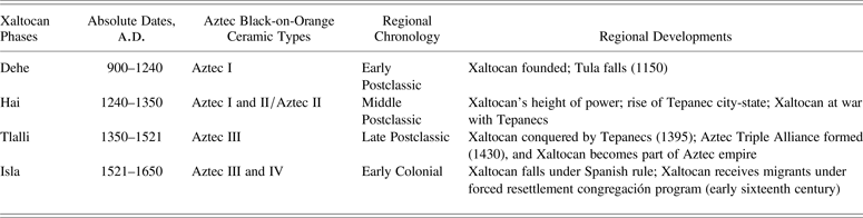
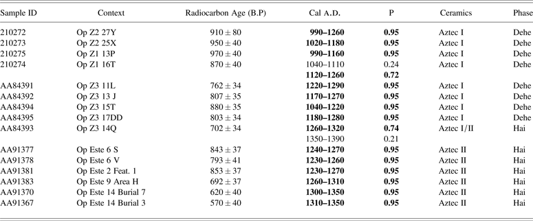
In the resulting Bayesian model of Xaltocan occupation (Overholtzer Reference Overholtzer2014) (Table 1), the Dehe phase, from a.d. 900 to 1240, is defined by the use of Aztec I ceramics. This model confirms De Lucia's (Reference De Lucia2011) findings that Aztec I ceramics were used exclusively until approximately a.d. 1250. The Hai phase, from a.d. 1240 to 1350, is characterized by the adoption of Aztec II pottery. What Brumfiel previously characterized as Phases 2 and 3 were subsumed within the Hai phase after attempts by Overholtzer to create a Bayesian statistical model in which Phases 1, 2, and 3 were abutting and not overlapping were unsuccessful due to the complete overlap in Phase 2 and 3 radiocarbon dates. New excavations and more samples also revealed that what was previously called Phase 4 could be divided into pre-Hispanic and Colonial phases. The Tlalli (or Late Postclassic) phase, from a.d. 1350 to 1521, is characterized by the use of Aztec III ceramics and extremely small quantities of Aztec IV ceramics. Finally, the Isla phase, from 1521 to 1810, saw the use of both Aztec III and IV ceramics in significant quantities. In the revised chronology, the Dehe, Hai, Tlalli, and Isla phases roughly correspond to the periods of Xaltocan's founding and rise to power, war and height of the polity, conquest and imperial rule, and colonial rule, respectively (Table 1). We use the new chronology here.
Chronology of Xaltocan occupation
Comparison of the extensive horizontal excavations of De Lucia (Reference De Lucia2011) and Overholtzer (Reference Overholtzer2012) revealed that households that would have been classified as Phase 2 and 3 in Brumfiel's chronology were, in fact, contemporaneous (De Lucia and Overholtzer Reference De Lucia and Overholtzer2014). Radiocarbon determinations indicate that both the latest occupation of the Op Z house excavated by De Lucia (which would have been classified as Phase 2 by Brumfiel) and the Op Este houses excavated by Overholtzer (which would have been classified as Phase 3) dated to the thirteenth and fourteenth centuries and were likely contemporaneous (Table 2). A midden from the final occupation phase of Structure 129 (Op Z) that contained both Aztec I and Aztec II ceramics yielded a radiocarbon date calibrated at a 95 percent probability to either 1260–1320 (p = .74) or a.d. 1350–1390 (p = .21). We note here that the former range is more likely given that the deposit does not include the Aztec III ceramics that dominate assemblages post-dating 1350 (Overholtzer Reference Overholtzer2014). This deposit was preceded by Aztec I occupation with a series of eight radiocarbon dates with 95 percent probability ranges of 990 to 1290. A fine-grained chronology for the Structure 122 (Op Este) household created using Bayesian statistical modeling that incorporated stratigraphic information (Overholtzer Reference Overholtzer2015a) revealed a period of chronological overlap with the Structure 129 household (we note that unfortunately, Bayesian modeling of the Op Z house has not been conducted, and thus, their date ranges have not been narrowed based on stratigraphic information). On Structure 122 (Op Este), two stratigraphically superimposed middens containing pure Aztec II ceramics yielded radiocarbon dates estimated in a Bayesian statistical model of this mound's occupation at 95 percent probability to a.d. 1230–1260 and 1240–1270 (Overholtzer Reference Overholtzer2015a) (Table 2). A midden with similar ceramics on a mound just twenty meters away yielded a similar radiocarbon date of a.d. 1230–1270 (AA91381 in Table 2), confirming the early-to-mid thirteenth century dating of the earliest occupation of this newly formed part of the island. Aztec II deposits on Structure 122 continued to approximately a.d. 1350; human remains from two burials associated with Aztec II pottery yielded radiocarbon dates estimated in the Bayesian statistical model at a 95 percent probability to a.d. 1300–1350 and 1310–1350 (Table 2).
Radiocarbon determinations from Dehe and Hai phase household occupation, 2–sigma probabilities
NOTE: Date ranges and probabilities for Op Z radiocarbon dates were calculated by the OxCal 4.1 calibration software. Date ranges for Op Este samples were estimated with a Bayesian statistical model of occupation on these mounds (Overholtzer Reference Overholtzer2012, Reference Overholtzer2015a). Bayesian statistical modeling was performed using two online Bayesian radiocarbon calibration tools: BCal and OxCal 4.2. BCal (http://bcal.sheffield.ac.uk) is hosted by the Department of Probability and Statistics at the University of Sheffield (Buck et al. Reference Buck, Christen and James1999). OxCal is hosted by the Radiocarbon Accelerator Unit at Oxford University (Bronk Ramsey Reference Bronk Ramsey2009). Nearly identical results were obtained (cf. Overholtzer Reference Overholtzer2012:120–122), though OxCal produced slightly more conservative posterior calendar year probability distributions. We report here the more conservative OxCal estimates and note that the comparable results indicate that the proposed model is robust. For each sample, the calibrated date range with the highest probability is indicated in boldface type.
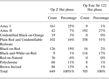
These excavations also indicate that Hai phase (a.d. 1240–1350) Op Este residents who dwelled on the newly formed lakeshore had radically different consumption patterns than did occupants of the contemporaneous Op Z houses. The latter demonstrated continuous occupation with earlier Aztec I houses, and thus represent occupational continuity since the founding of the site in the now-center of the island (Table 3). With regard to Black-on-Orange ceramics, the Op Este deposits had nearly exclusively Aztec II wares (27 percent of all decorated wares; only 1 percent Aztec I), while the contemporaneous Op Z contexts included both Aztec I and Aztec II pottery (25 percent Aztec I, 7 percent Aztec II) (Table 3). A chi square test revealed that this difference is statistically significant at p < .01. It is possible that the latter pattern results from mixing of deposits, since the Op Z deposit was an intrusive pit into the Aztec I period structure, or from curating or heirlooming practices, wherein the Aztec I vessels were simply handed down within the long-occupied houses in the center of the island and were absent from newly settled ones on the periphery. Alternatively, since Aztec I ceramics constitute a full 25 percent of the decorated rim sherds, it is possible that residents continued to consume Aztec I pottery in smaller quantities, as populations at other sites, such as Ch-Az-195, appear to have done. Regardless, dramatic differences in other ceramic types also differentiate these households, reflecting actual differences in consumption practices between a.d. 1240 and 1350. For example, there is an inverse relationship between the popularity of Black-on-Red and Black-and-White-on-Red redware variants: Black-on-Red dominates the Op Z house assemblage (at 19 percent vs. 1 percent Black-and-White-on-Red), while Black-and-White-on-Red is most common in the Op Este house assemblages (17 percent vs. 2 percent Black-on-Red) (Table 3). A chi square test revealed that this difference is statistically significant at p < .01. In addition, Brown Incised ware is common in the Op Z assemblage (13 percent of all decorated wares) and nearly nonexistent in the Op Este assemblages (less than 1 percent), a difference demonstrated by a chi square test to be statistically significant at p < .01 (Table 3).
Decorated serving ware total sherd frequencies from contemporaneous Hai phase interior (“legacy”) and periphery (“settler”) household deposits
While it is difficult to generalize based on a single domestic deposit, the Op Z house conforms to patterns Brumfiel observed in other excavations and that she associated with what she called Phase 2. Thus, Phase 2 seems to be representative of a particular kind of assemblage, a particular consumption pattern, rather than being a chronological marker. Similarly, the Aztec II middens recovered in Op Este parallel Brumfiel's findings for Phase 3. Moreover, this distinction is reflected site-wide in the survey settlement pattern data, which indicates dense, centralized Aztec I and Aztec I/II settlement, and more dispersed Aztec II settlement, with significantly denser occupation on the newly formed edges of the island (Chimonas Reference Chimonas and Brumfiel2005:191). Thus, during the Hai phase (a.d. 1240–1350), Xaltocan inhabitants were largely divided into two contemporaneous groups who displayed markedly different ceramic consumption patterns.
At this transition—associated with the adoption of Aztec II ceramic vessels at approximately a.d. 1240—we see not only significant differences in consumption practices, but also in social organization and household ritual practice. In this paper we explore these differences, focusing particularly on archaeological evidence for the rise of two contemporary subpopulations with distinct material practices. Brumfiel's surface collection and test pit excavations revealed several changes in settlement pattern and economic activities at the site with the arrival of Aztec II ceramics (Brumfiel Reference Brumfiel2005:357–361), though these transformations remained poorly understood because the chronological (and thus political) context for the phase was unclear. The authors’ recent horizontal excavations—which offer firmly dated, contextual data on household architecture, domestic refuse, and residential burials located near the center and peripheries of the site (see also De Lucia and Overholtzer Reference De Lucia and Overholtzer2014)—allow us to further investigate this shift, identify its manifestation at the microlevel, and study its causes.
THE DEHE-HAI PHASE TRANSITION AT XALTOCAN: SITE-LEVEL CHANGES
At a.d. 1240, with the adoption of Aztec II pottery, Xaltocan witnessed significant demographic and economic transformations at the site-wide level. Survey data indicate that at this time, Xaltocan's population increased by 19 percent (Chimonas Reference Chimonas and Brumfiel2005:173). Excavations on the eastern edge of the site by Overholtzer revealed that a substantial layer of fill—a meter thick, on average—containing mixed Aztec I and II ceramics was placed on top of the lakebed; under this fill layer only culturally sterile deposits were encountered. Houses were then constructed on top of this mixed fill, suggesting that the fill was used to raise the level of the lakebed above the water to support additional habitation. The presence of Aztec I and Aztec II ceramics in the fill suggests that the expansion of the human-made island to accommodate more residents took place sometime after Aztec II ceramics were introduced to the region; radiocarbon dates from the earliest deposit indicate that it must have happened by the mid-thirteenth century (Overholtzer Reference Overholtzer2012).
Data from survey and excavations demonstrate that when the island was expanded to accommodate a larger population, residents dramatically increased their externally oriented production. Christopher Morehart (Morehart Reference Morehart2010; Morehart and Eisenberg Reference Morehart and Eisenberg2009) determined that residents constructed an expansive chinampa system of canals and raised fields around this time. Morehart's paleoethnobotanical analysis of carbonized plant remains, phytoliths, and pollen from archaeological samples of the chinampas indicate that Xaltocan residents grew corn, beans, and squash, and cultivated wild species, including amaranth and chenopodium, but that corn was by far the most common crop. This chinampa system, the largest of its kind in pre-Aztec central Mexico at a size of at least 1,500 ha, was capable of producing enough food for 15,000 people, three times the number of residents at the town's maximum extent. Morehart (Reference Morehart2014) argues that population pressure cannot explain this capability for surplus, and instead, that surplus production was linked to the growing demands of the Xaltocan city-state (see also De Lucia and Morehart Reference De Lucia, Morehart, Morehart and De Lucia2015). Xaltocan ruling elites may have used surplus to pay officials, finance events to create and maintain political alliances, or support warriors, and surplus corn could also have been used to obtain nonlocal products via market exchange (Morehart Reference Morehart2014:160–1).
Survey data also indicate that with the arrival of Aztec II wares, Texcoco Fabric-Marked pottery of the kind used to produce and transport salt appears at the site, and is concentrated around the newly formed lakeshore (Brumfiel Reference Brumfiel2005:141; Chimonas Reference Chimonas and Brumfiel2005:191, Figure 6.11). Brumfiel (Reference Brumfiel2005:141) hypothesized that crude bowls may have been used for salt production before the rise of the Texcoco Fabric-Marked tradition, and microartifact and multi-element chemical analysis of floor samples confirm that some households specialized in the salting of fish, likely for market exchange, even in the Dehe phase (De Lucia Reference De Lucia2011, Reference De Lucia2013).
The appearance of fabric-marked pottery in Xaltocan might indicate novel salt production techniques or a shift from salt production to salt consumption through market exchange. Salt was consumed for household use, as well as for the production of goods destined for the market, such as salted fish or dyed cloth (Chimonas Reference Chimonas and Brumfiel2005:191; De Lucia Reference De Lucia2013). Elsewhere (De Lucia and Overholtzer Reference De Lucia and Overholtzer2014), we have reconstructed and compared the economic practices of the houses excavated, but here cite the evidence for salt production and use, as it is particularly relevant. Texcoco Fabric-Marked pottery was significantly more ubiquitous in the Hai phase houses on the lakeshore: Op Este Hai phase middens featured a frequency of 17.5 such salt vessel sherds per 100 rims (n = 748), compared with the Op Z Hai phase frequency of 2.7 sherds per 100 rim sherds (n = 42), a statistically significant difference at p < .01. However, direct comparison of the quantity of salt used in these settings is complicated by the fact that crude bowls, possibly salt production vessels, were still in use in the Op Z households at this time (with a frequency of 5.1 rim sherds per 100 rim sherds, n = 56; rim sherds are used here because they are more diagnostic), but not in the Op Este households (n = 0), also statistically significant at p < .01. Further complicating this comparison, Texcoco Fabric-Marked pottery is fragile due to thin vessel walls and high content of organic temper, and is often recovered in small fragments, while crude bowls are sturdy vessels that are frequently recovered as large fragments or even as complete vessels. A comparison of these data in the Op Z and Op Este households is also difficult because the archaeological record has not provided clear evidence to help us distinguish between salt production and consumption.
The higher frequency of Texcoco Fabric-Marked pottery in the Op Este households might indicate intensive salt production, as described for Xaltocan in colonial documents (AGN Tierras 1584/1 1711). This would suggest that people settling on the new lakeshore in the early-to-mid- thirteenth century took advantage of their access to saline lacustrine resources and the ease of boat transport for exchange, as the Op Z inhabitants had done before them, and produced salt for market sale. However, excavations recovered no direct evidence for this production in the form of ovens or Texcoco Fabric-Marked misfires, as hypothesized by ethnoarchaeological investigations in the Basin of Mexico (Parsons Reference Parsons2001), and as has been found for salt producing households at nearby San Bartolomé Salinas (Millhauser Reference Millhauser2012). Nevertheless, it is feasible that workshops may have been slightly removed from the house mound, and thus not within the excavation area. In fact, the saltmaking workshops described in Parsons’ archaeological ethnography in Nexquipayac in the Basin of Mexico are generally located some distance away from the residential cluster (Parsons Reference Parsons2001).
Given the absence of direct evidence for production, it is also possible that this high frequency reflects intensive salt consumption. It is possible that Op Este settlers were greater consumers of salt, engaging in the intensive production of goods such as salted fish or dyed cloth for market salt. Again, this would suggest that settlers to the new lakeshore oriented their household production practices to their lacustrine setting. Specialized production is nearly always associated with poverty in the ethnographic literature (Millhauser Reference Millhauser2012:66), and as we will see, the settler community indeed seems to have had a lower socioeconomic status than existing residents. The evidence for intensive production of either salt or goods that required salt is thus consistent with their marginalized status within the Xaltocan community.
It is also possible that these households were obtaining salt in different ways: Op Z producing some salt and obtaining some salt via market exchange, and Op Este purchasing all of their salt in the market. This would imply that differences in household practices extended beyond the consumption of decorated pottery to include how household production was organized. Given that the Op Z houses were larger than the Op Este houses, they likely contained larger households that would have organized and employed their labor differently, as more household members would have been available to participate in the division of tasks. In contrast, the smaller Op Este households may have reduced the number of household tasks by obtaining salt through the market.
Thus, people settling on the new lakeshore in the early-to-mid-thirteenth century likely engaged in intensive household production of goods that took advantage of their access to lacustrine resources and the ease of boat transport for exchange, as the Op Z inhabitants had done before them. However, they may have differently organized household labor and production.
The material record also indicates an increase in market consumption practices of Xaltocan residents after approximately a.d. 1240 (Brumfiel Reference Brumfiel2005:145; Chimonas Reference Chimonas and Brumfiel2005:191). Instrumental Neutron Activation Analysis (INAA) of decorated serving vessels from test pit excavations revealed a significant trend toward increasing consumption of imported pottery. Nichols et al. (Reference Nichols, Brumfiel, Neff, Hodge, Charlton and Glascock2002) analyzed 19 Aztec I Black-on-Orange sherds and six redware sherds, representing consumption patterns during the Dehe phase between a.d. 900 and 1240, as well as 17 Aztec II Black-on-Orange sherds and 32 redware sherds, indicating consumption practices during the Hai phase from a.d. 1240 to 1350. These sample sizes were chosen in accordance with the changing frequencies of these types, although the individual sherds were chosen based on the presence of clear design motifs. Of those 25 Dehe samples for which provenience could be determined, 52 percent (n = 13) were locally produced, while the rest came from locations spread across the Basin of Mexico, including Cuauhtitlan (8 percent; n = 2), Tenochtitlan/Culhuacan (16 percent; n = 4), Chalco (8 percent; n = 2), Southern Basin 1 (4 percent; n = 1), and Southern Basin 3 (12 percent; n = 3). In contrast, of the 48 Hai phase samples for which provenience could be determined, only 33 percent (n = 16) were locally produced, and the majority came from a wider variety of sources, including the Cuauhtitlan (29 percent; n = 14), Southern Basin 1 (13 percent; n = 6) and 3 (15 percent; n = 7), Tenochtitlan/Culhuacan (6 percent; n = 3), Chalco (2 percent; n = 1), and Otumba-Macro (2 percent; n = 1) groups. Imported ceramics thus shifted from only 48 percent of the sample in the Dehe Phase to 67 percent during the Hai Phase. A second INAA study by Hodge and Neff (Reference Hodge, Neff and Brumfiel2005) with a sample of 47 Black-on-Orange sherds from Xaltocan found similar results: more ceramics were imported after the arrival of Aztec II pottery, since Xaltocan potters apparently did not produce Aztec II Black-on-Orange pottery, as they did Aztec I wares. This parallels the findings at Chalco, where Aztec I pottery was locally produced, but Aztec II appears to have been an intrusive ware not made locally (Parsons et al. Reference Parsons, Brumfiel and Hodge1996). In addition, Hai phase Xaltocan imported wares predominantly came not from the southern Basin of Mexico, but instead from Cuauhtitlan, as we might expect based on the distribution of Aztec I and II wares within the Basin of Mexico overall.
Other ceramic forms, such as figurines, also follow the pattern of increasing importation from a wider variety of production locales. A sample of 39 Aztec figurines spanning the site's occupation were also analyzed using INAA (Overholtzer and Stoner Reference Overholtzer and Stoner2011; Overholtzer et al. Reference Overholtzer, Glascock and Stoner2008). The sample was formed using a stratified random sampling method on the basis of figurine type: first, the sample size for each figurine type was determined based on their frequency in the collection, and within each category, figurines were then randomly selected from those artifacts complete enough to assign a type. Of these, imported figurines constituted only 14 percent of the assemblage (n = 1) in the Dehe phase, while in the Hai phase, they accounted for 53 percent (n = 9). Geographically, the figurines reflect similar trends in exchange patterns as decorated serving vessels. In the Dehe phase, imported figurines were provenienced to the Southern-Basin 1 group (n = 1), likely reflecting manufacture near Chalco, while Hai phase figurines came from a wider variety of sources, including Cuauhtitlan (n = 2), Otumba (n = 2), Tenochtitlan (n = 2), and the Southern-Basin 1 (n = 1) and 3 (n = 2) groups. In sum, Xaltocan residents after a.d.1240 were more externally oriented in terms of their market consumption.
THE DEHE-HAI PHASE TRANSITION AT XALTOCAN: HOUSEHOLD CHANGES
Moving to the microlevel of individual households, extensive domestic excavations dating to the Dehe phase conducted in three locations provide relevant data. First, Brumfiel (Reference Brumfiel2010) exposed at least three rooms and an outdoor patio of Casa G, located on the northern side of the site. While the full extent of the domestic structure was not determined, the presence of multiple hearths in different rooms of the same stratigraphic layer suggests that it housed multiple families or households, and thus could be characterized as a house compound (see Smith [Reference Smith, Santley and Hirth1993] for a discussion of archaeological and ethnohistorical evidence for household organization). The house compound was roughly oriented to the cardinal directions with adobe walls and earthen and adobe floors, and had at least three construction phases and twelve stratified floors; occupation likely continued through the Hai phase, though those deposits had subsequently been disturbed (De Lucia and Overholtzer Reference De Lucia and Overholtzer2014). Dehe phase Casa G radiocarbon samples were estimated at 95 percent certainty to 900–1060 (p = .76) or 1080–1150 (p = .17) and 890–1030 (p = .95) in a Bayesian statistical model of the site's occupational history (Overholtzer Reference Overholtzer2014), while a sample from the Hai phase disturbed deposits was estimated at 1240–1360 (p = .95).
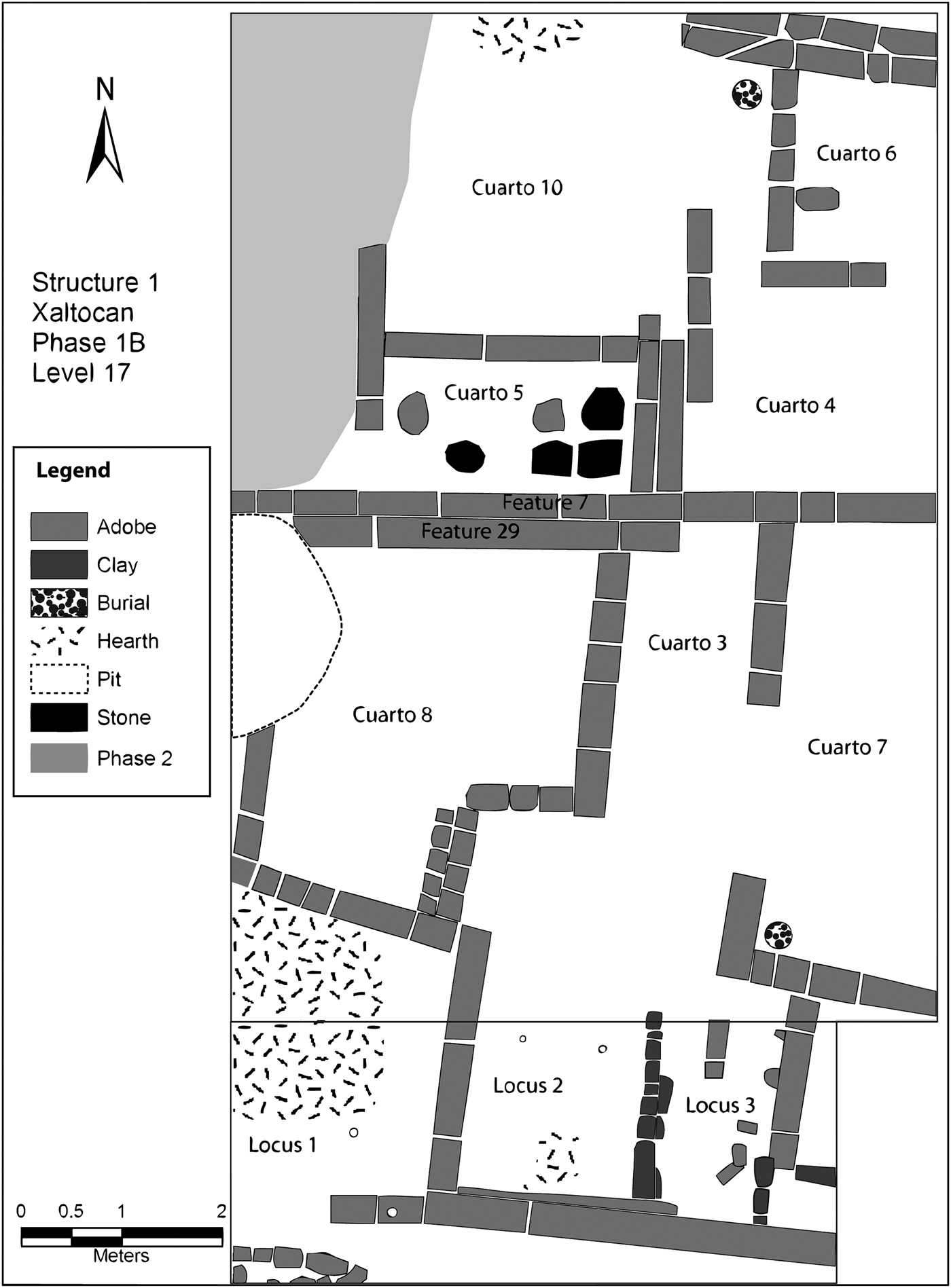
Second, De Lucia (Reference De Lucia2011, Reference De Lucia2013) excavated several rooms of two house compounds in Op Z near the center of the site (Figure 8). The houses in these compounds each had separate hearths and middens, and were occupied in the Dehe phase between approximately a.d. 1000 to 1240 and into the Hai phase, some time in the late thirteenth or early fourteenth centuries. Excavations recovered a series of six earthen floors placed during the Dehe phase, and a shift to plaster floors in the Hai phase (Figure 9). While this house was disturbed by later colonial era occupation, painted pieces of plaster in domestic debris suggest that the Hai phase house may also have featured painted murals (De Lucia Reference De Lucia2011, Reference De Lucia2013). Moreover, in Brumfiel's test pit survey of the site, plaster floors were only found in the site core.
Plan map of Op Z, Level 17 (160–170 cm). Note burials in corners of Cuartos 7 and 10.
Adobe wall from Op Z, showing plaster floor associated with Hai phase Aztec I and II occupation directly over Dehe phase Aztec I household architecture.
This higher investment in domestic architecture in this and other centrally located house compounds suggests an increase in household wealth of some of the site's original inhabitants—that is to say, increased social stratification at the site, perhaps a consequence of the Otomi city-state's rise to power (De Lucia and Overholtzer Reference De Lucia and Overholtzer2014). This conclusion is also supported by an increase in the ratio of decorated to undecorated pottery, from 0.30 to 0.45, in Op Z Dehe and Hai phase deposits, respectively.
These excavations also provide evidence of the spatial organization of household life during the Dehe occupational phase, which was better preserved in this context. De Lucia's microartifact and soil chemical analyses of intact floors (Reference De Lucia2011, Reference De Lucia2013) suggests that in these multiroom house compounds, outdoor patios served as both ritual and productive space, while interior rooms were more specialized. Rooms were designated for sleeping, socializing, and engaging in intensive production activities, such as mat-making and fish processing (De Lucia Reference De Lucia2013).
Thus, across the site, the houses founded in the earliest occupation phase are multiroom, apartment-like compounds, suggesting that multiple families or households would have cooperated in daily tasks and ritual activities (De Lucia Reference De Lucia2010, Reference De Lucia2011, Reference De Lucia2013, Reference De Lucia2014; De Lucia and Overholtzer Reference De Lucia and Overholtzer2014). These houses were constructed of adobe walls oriented to the cardinal directions and placed on clay foundations; rooms were likely differentiated in function. Houses were renovated, expanded, and modified over time, but occupants often reused previous walls. These houses were often occupied into the Hai phase, as residents adopted Brown Incised and Aztec II pottery alongside the Aztec I ceramics they had used for centuries.
In contrast, the houses founded on the newly formed lakeshore at this same time, whose residents consumed mainly Black-and-White-on-Red and Aztec II pottery, demonstrate a remarkably different pattern of household organization (De Lucia and Overholtzer Reference De Lucia and Overholtzer2014). The Op Este clearing excavations of two house mounds, Structures 122 and 124 (Overholtzer Reference Overholtzer2012), in their entirety revealed a clear pattern of single-room houses that would have been occupied by a single household composed of smaller nuclear or joint families, perhaps five to eight individuals, based on ethnohistoric records (Smith Reference Smith, Santley and Hirth1993:201) (Figure 10). Remote sensing and additional excavations confirmed that houses were not constructed off-mound until the late colonial period, perhaps the seventeenth or eighteenth centuries. This pattern continued through the imperial Aztec period on one mound and the early colonial era on another. Structure 122, for example, featured a series of four small, single-room houses, sometimes complemented by a small, round circular structure, possibly a granary or sweat bath, that were occupied through the Colonial era. Only in the Colonial period on one of the mounds do we see the appearance of large house compounds. Excavations on Structure 124 revealed that an imperial Aztec period single-room house was torn down and replaced by an extremely large house compound featuring three rooms, two interior patios, and two small storage rooms during the Colonial period. As in the Dehe phase renovations, excavations revealed significant spatial continuities in the placement and orientation of the dwellings constructed through time, and in the case of the colonial multiroom house, the previous single-roomed structure was replicated in nearly identical form as one of the rooms (Overholtzer Reference Overholtzer, Overholtzer and Brumfiel2015b). However, in each construction episode, the previous house was leveled and a new one was constructed; previous walls were not reused as was common in the earlier houses at the center of the island. Moreover, unlike the multiroom Dehe and Hai phase houses in the center of the island, activities could not have been spatially differentiated in the same way in these single-room houses. Instead, features such as hearths were located in exterior, open patio-like spaces, suggesting that household production would have been carried out outside.
Map of Op Este household architecture, middens, and burials on Structure 122 demonstrating superimposed structures spanning the Hai to Isla phases (a.d. 1240–1650).
Thus, at approximately a.d. 1240, with the adoption of Aztec II pottery in the Hai phase, we see the presence of two models of household organization: 1) what could be called “legacy” households, representing continuous occupation from the Dehe phase, which consumed Brown Incised ware, Black-on-Red ware, and continued to use Aztec I pottery alongside the newly arrived Aztec II ware and continued to dwell in large, multihousehold or multifamily house compounds; and 2) “settler” households, who built their homes on newly formed land, who preferred Aztec II pottery and Black-and-White-on-Red wares, and who dwelled in small households occupying a single room.
Op Z Hai phase “legacy” contexts also had more polychrome ceramics (11 percent of the decorated wares vs. 1 percent in the Op Este “settler” contexts, a statistically significant difference at p < .01 in a chi square test) (Table 3). Since household possessions are generally useful indicators of wealth in state-level societies (Bawden Reference Bawden1982: 175; Blanton et al. Reference Blanton, Kowalewski, Feinman and Appel1981:246ff; Smith Reference Smith1987:314; Smith and Heath-Smith Reference Smith and Heath-Smith1980:31), and higher frequencies of valuable, elaborately painted serving vessels, in particular, are generally used by archaeologists to infer status and wealth, the higher ratio of polychrome ceramics in the Op Z Hai phase “legacy” house suggests its occupants may have been wealthier. Size and quality of residential architecture is also a generally reliable indicator of wealth (Smith Reference Smith1987). The much larger house with plaster floor in the contemporaneous Op Z house confirms that class differences may also separate at least some of the “legacy” and “settler” households.
However, the most striking difference in these two households—and one that cannot be easily explained by class variability—relates to the spatiality of funerary practices. As we will demonstrate, the site's original inhabitants and their “legacy” descendants buried only children in the domestic context, all under house floors, while the “settler” households buried men, women, and children together in outside domestic patio space.
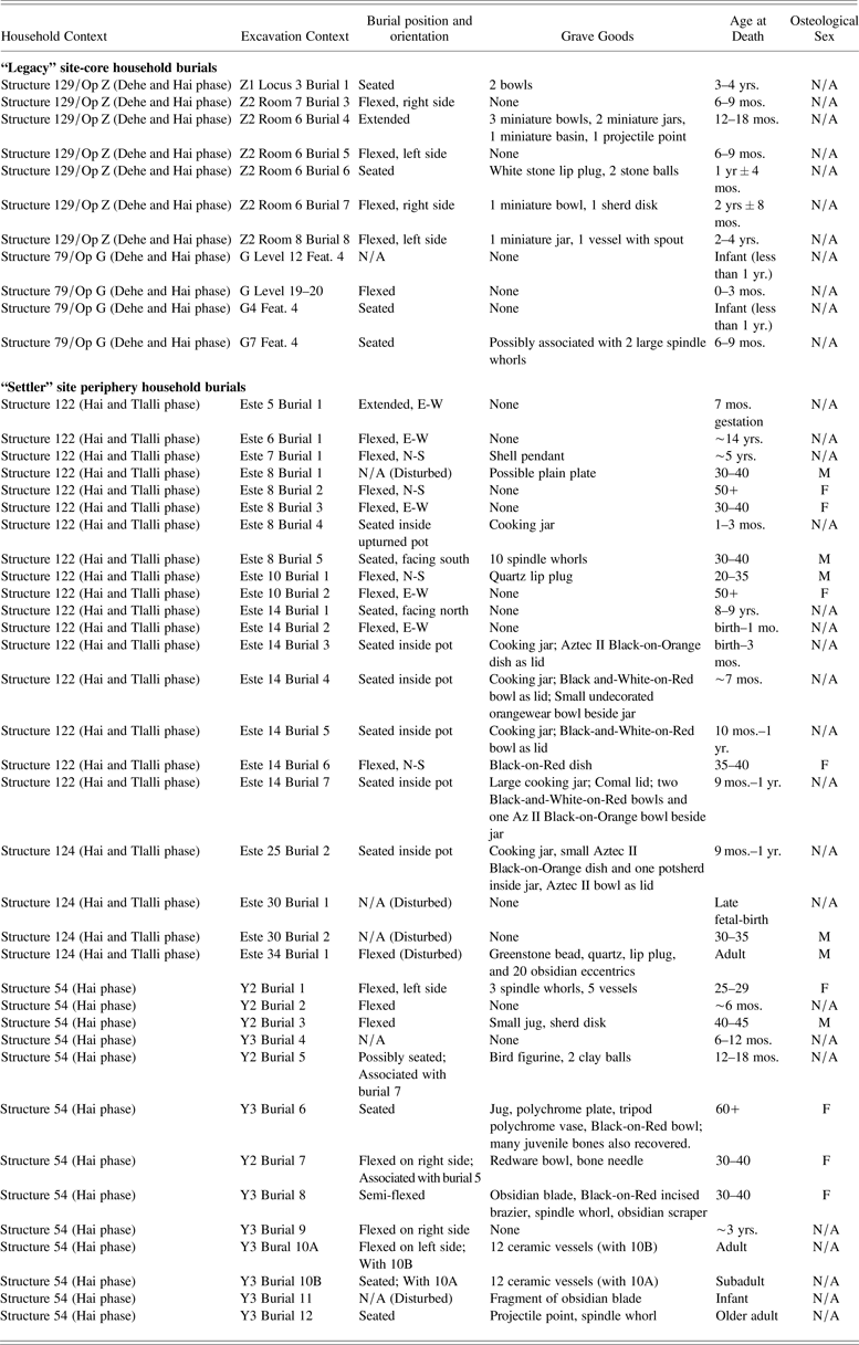
Excavations of Dehe-phase houses in all four locations mentioned earlier revealed a widespread pattern of infant burials within the confines of the domestic structure (Table 4). In these houses, the remains of 16 infants and children under the age of four were recovered underneath house floors. The infants lacked grave goods, while children aged one year and older were most often provided offerings, especially miniature vessels, suggesting a division within this age grade (De Lucia Reference De Lucia2010). Infants and children were most often interred in the corner of rooms and often cutting into house walls, and the same corners were often reused across occupational phases, indicating continuity in social memory and the important role of infants and children in those memories (De Lucia Reference De Lucia2010). In those Dehe-phase houses that continued to be occupied in the Hai phase, this pattern of exclusively infant and toddler burial within house walls was maintained. In Op Z, for example, a neonate was buried in a simple grave near an adobe wall associated with Hai-phase deposits.
Xaltocan burials from interior (“legacy”) and periphery (“settler”) households
Significantly, not a single adult interment dating to the Dehe phase has been recovered at the site, suggesting differential funerary treatment based on age. It is possible adults were buried in a communal cemetery, or they may have been cremated, though archaeological research has yet to reveal evidence of such adult remains. Dehe- and Hai-phase deposits occasionally include fragments of dog effigy vessels, which, in being hollow and representing an animal associated with the journey to the afterlife in later Aztec thought, may have served as funerary urns (Brumfiel and Overholtzer Reference Brumfiel, Overholtzer, Halperin, Faust, Taube and Guiget2009). At least one Hai-phase burial in Op Z was directly associated with the remains of a puppy, suggesting this association was also present in the Middle Postclassic period at Xaltocan (De Lucia Reference De Lucia2014).
Few excavations of burials in Early Postclassic central Mexican household contexts have been carried out to date, and it is therefore difficult to define geographical variations in burial practices. Existing data suggest a significant amount of variability across central Mexico in the Early Postclassic. At Río Viejo in coastal Oaxaca (King Reference King, Ardren and Hutson2006, Reference King, Adams and King2011), only adults were buried under house floors, and children appear to have been buried outside of houses, while at the sites of Tlapizáhuac in the southeastern Basin of Mexico (Ahumada Reference Ahumada1998; Favila Cisneros and García Sánchez Reference Favila Cisneros and Sánchez2002) and Tepetitlán in the Tula area, infants, children, and adults were interred under house floors (Cobean and Guadalupe Mastache Reference Cobean and Mastache1999). At Huamango in the state of Mexico, residents appear to have practiced a combination of primary interment, secondary burial, and the placement of cremated remains in jars, though the age and sex of these patterns are not discussed by the author (Bonfil Olivera Reference Bonfil Olivera2004). The Xaltocan burials provide two additional distinct patterns.
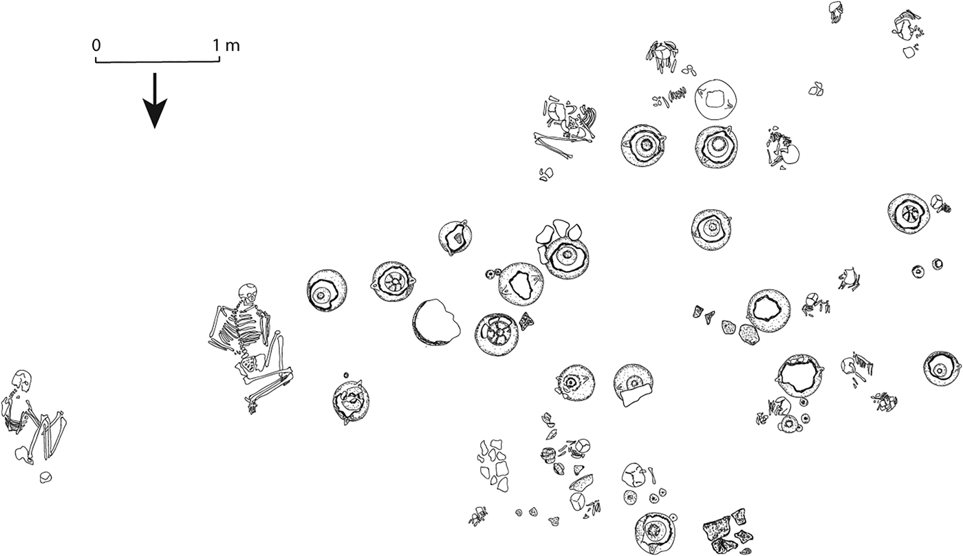
This clear pattern of the exclusive interment of infants under house floors at Xaltocan in the Dehe phase and by their “legacy” Hai-phase descendants contrasts markedly with the pattern seen in “settler” households founded on the newly formed lakeshore after a.d. 1240. Excavations on Structures 122 and 124 recovered 21 primary burials in association with seven houses likely representing two households rebuilt several times over the course of the Hai and Tlalli phases (Overholtzer Reference Overholtzer2012) (Table 4). These individuals, representing men, women, children, and infants, were all interred in tight clusters outside of houses in areas that have been interpreted as external patios. No burials were recovered underneath house floors. Sixteen of the individuals were interred within a 5 × 7 meter area to the west of a series of three houses on Structure 122. Samples of bone from these burials were radiocarbon dated and estimated in a Bayesian statistical model to span the early fourteenth to early sixteenth centuries.
On these two mounds, some of the infants had been interred inside used cooking jars, often with upturned Aztec II Black-on-Orange or Black-and-White-on-Red dishes or bowls covering the lid (Figure 11). Of these, five dated to the Hai phase and one dated to the Tlalli phase, and the infants ranged in age from birth to one year. A comparable burial of a neonate inside a cooking jar was recovered in a salvage operation located on the northern side of the island (De Lucia and Brumfiel Reference De Lucia and Brumfiel2004). Though we lack detailed context information for this burial, its presence indicates that infant burial inside cooking jars is not unique to the southeastern edge of the island, and instead is perhaps a pattern present in the periphery of the island.
Aztec II infant burials inside cooking jars outside of a house on Structure 122 (Op Este).
Op Y excavations on Structure 54 to the northeast of Op Este revealed a similar group of 13 tightly clustered adults, children, and infants buried during the Hai phase (De Lucia and Brumfiel Reference De Lucia and Brumfiel2004; De Lucia Reference De Lucia2010) (Table 4). All of the Black-on-Orange pottery interred as burial offerings and recovered in adjacent domestic debris was Aztec II. Though excavations did not extend significantly beyond the burial area, and thus no adjacent domestic structure was located, the burials were located on a house mound. Combined with the similarity of these burials to the contemporaneous Op Este ones, these data suggest that these individuals may have been interred in an external patio. In contrast with the Op Este houses, these people did not create new land, but rather raised and leveled the ground surface by placing fill over the preexisting mound. This fill also covered the remains of a Dehe phase house several meters away that had been abandoned and, based on the presence of a large burned area with abundant burned corn cobs, ceramic balls, and ritual objects, such as censers and braziers, had been ritually terminated (Brumfiel Reference Brumfiel2010). Interestingly, preliminary ancient mitochondrial DNA evidence suggests that at least one member of this household shared a unique, derived haplotype with three Op Este infants buried during the same period (Mata-Míguez et al. Reference Mata-Míguez, Overholtzer, Alegría, Kemp and Bolnick2012). This shared haplotype is rare, but has been detected in other American populations, including one ancient sample from coastal southern Peru (Fehren-Schmitz et al. Reference Fehren-Schmitz, Reindel, Tomasto-Cagigao, Hummel and Herrmann2010) and one modern Quechua individual (Gayà-Vidal et al. Reference Gayà-Vidal, Moral, Saenz-Ruales, Gerbault, Tonasso, Villena, Vasquez, Bravi and Dugoujon2011). While we do not understand the ubiquity of this haplotype at Xaltocan, its relative rarity in the Americas suggests that the Op Y and Op Este settlers were maternally related.
Collectively, these excavations demonstrate that during the Hai phase, families that settled on the newly formed peripheries of the island and in vacant space available on the preexisting island buried people of all ages and both sexes in external patio areas; their descendants who adopted Aztec III pottery continued to bury their dead in this fashion. These residents were sometimes given burial offerings, most often decorated pottery, especially Black-on-Orange, Black-and-White-on-Red, and Chalco polychrome wares. In contrast with the Dehe phase burials, where infants under one year were interred without grave goods, the Op Este infants that had been placed inside cooking jars were often accompanied by several decorated serving vessels, serving as a lid and placed either alongside or inside the jar (Table 4). There is no clear association between the age of the individual and the quantity of associated grave goods, though it appears that the infants just mentioned and some older adults received more offerings than others.
As with the Early Postclassic, few excavations of Middle and Late Postclassic household funerary contexts have been undertaken, and from these, no clear spatial patterning of burial norms has emerged. Salvage excavations at Culhua-Mexica Mexicaltzingo (Ávila Lopez Reference Ávila Lopez2006:295–302) recovered three subadults buried into the walls of a commoner domestic structure occupied during the Middle Postclassic; these burials were direct interments and were sometimes accompanied by offerings of Aztec II Black-on-Orange pottery. More extensive excavations have been carried out in Morelos at sites inhabited by the Tlahuica ethnic group, a Nahuatl-speaking Aztec group that, like the Mexica, migrated from the north. At rural Capilco and Cuexcomate, infants and children were occasionally buried under house floors or in exterior midden areas, and adults were conspicuously absent (Smith Reference Smith1992). Excavations at urban Yautepec recovered some burials of adults and subadults often in clusters near hearths outside single-room houses (Smith et al. Reference Smith, Heath-Smith and Montiel1999). Overall, few burials were encountered, leading Smith (Reference Smith and Plunket2002) to suggest that in Aztec society, most family members must have been interred in cemeteries.
The Xaltocan “settler” Aztec II and III burials most closely resemble excavated contexts at Tula, Hidalgo, to the north of the Basin of Mexico, specifically those from the Tollan Tardío phase (Gómez Serafín et al. Reference Gómez Serafín, Sansores and Dávila1994). According to Gómez Serafin, these burials likely date to the thirteenth through fifteenth centuries, the period associated with the arrival of Aztec III pottery and the subjugation of the polity by the Tepanecs, a Nahuatl-speaking Aztec ethnic group from the west side of the Valley of Mexico that is said to have migrated from the north alongside the Mexica. Though the Tula chronology is poorly defined, the association with Aztec III pottery (consumed at Xaltocan after a.d. 1350) suggests that these burials are perhaps a century later in date than the earliest Xaltocan settler households. Beginning at this time, the Tula houses excavated by Gómez Serafín demonstrate a preference for burials of groups of adults and subadults in exterior space. This transition was also marked by a shift from projectile points, obsidian, blades, and human bones as grave goods to offerings of ceramics, mainly dishes, bowls, jars, and occasionally spindle whorls. The majority of the burials are subadults, and like the Hai-phase Op Este burials, many of the infants were interred inside cooking jars, with upturned bowls and dishes serving as lids (Figure 12).
Plan view of Unit 32 burials at Tula, including infants interred inside cooking jars. Redrawn after Gómez Serafín et al. Reference Gómez Serafín, Sansores and Dávila1994:Figure 51.
This striking pattern of juvenile burials inside jars was also common within sacrificial offerings of male children at the Mexica site of Tlatelolco, likely made during a devastating drought between 1454 and 1457 (De La Cruz et al. Reference De La Cruz, González-Oliver, Kemp, Román, Smith and Torre-Blanco2008). Here, 17 of the 30 juveniles buried in front of the circular temple dedicated to Ehécatl-Quetzalcóatl were interred inside large cooking jars, as was one adult; most of the jars were covered with upturned Aztec III shallow basins or dishes, or less commonly with comals (Guilliem Arroyo Reference Guilliem Arroyo1999).
Archaeologists often attribute variation in burial practices to ethnic identity and differences in cosmology, though rarely are simple one-to-one correspondence between burial type and identity seen. Recent work on residential burials (Adams and King Reference Adams and King2011; De Lucia Reference De Lucia2010, Reference De Lucia2014; Hodder and Cessford Reference Hodder and Cessford2004; Joyce Reference Joyce, Grove and Joyce1999, Reference Joyce and Chesson2001; Kuijt Reference Kuijt and Chesson2001, Reference Kuijt2008; McAnany Reference McAnany1995) also emphasizes careful consideration of the relationships between the living and the dead and the effects that such close proximity of people and their ancestors had on social relations, social memory, social reproduction, and relations of power.
The stark contrast between the Xaltocan Dehe phase and descendant “legacy” Hai phase households, in which only infants and children under the age of four were interred under house floors, and the new “settler” Hai phase and their descendant Tlalli phase burials, in which all household members were buried outside the house under the patio, suggests that these two subpopulations related to their dead in significantly different ways.
The Dehe phase and descendant “legacy” Hai-phase household burials at Xaltocan are relatively unique within contemporaneous Mexican groups. In the Early Postclassic (a.d. 975–1220) households in Oaxaca described by Stacie King (Reference King, Ardren and Hutson2006; Reference King, Adams and King2011), for example, it is children that are conspicuously absent. King has interpreted this pattern as indicating a house society context in which full-fledged membership, ancestor status, and the privilege of receiving commemorative burial practice within the physical confines of the house were at least partly age-dependent. Regardless of the reason for the distinction, King (Reference King, Adams and King2011:51) aptly notes that the existence of such a division indicates the presence of a “conceptual separation between child and adult burials and mortuary ritual.” Such a conceptual separation between child and adult burials was clearly in effect at Xaltocan, though it was children that received commemorative burial practice.
Unlike the Dehe phase and their descendant “legacy” Hai-phase occupants, the new settlers buried both adults and children in exterior patios, suggesting that they had a different kind of relationship with their adult dead than the site's original founders. They may have come from another place within central Mexico, where people had other embodied cultural practices, including different forms of household organization and use of household space. Comparison with excavated burials at other central Mexican sites demonstrates a close parallel in contexts at Tula associated with Tepanec rule. Even as these new settlers at Xaltocan adopted the tau-shaped obsidian lip plugs that outwardly marked them as Otomi, the ethnic group of the site's founders and reigning elite (Overholtzer Reference Overholtzer2015a), the spatial patterning of their daily and ritual lives set them apart.
Alternatively, maintaining distinct funerary practices—and funerary practices that materialized the history of their occupation in this place—may have proven beneficial to new settlers, who completed a nearly monumental task in expanding the size of the human-made island. They arrived during the Middle Postclassic, a period of increasing wealth and the height of Xaltocan's power, but also a period of growing instability and increasing unrest in the entire Basin of Mexico, including Xaltocan (Brumfiel Reference Brumfiel1983). As Adams and King (Reference King, Adams and King2011:5) explain, “The placement of burials in residential contexts can provide the living with a direct, ongoing connection to ancestors and a constant reminder of their place in what can be a long line of descendants originating from the founding ancestor of a household or larger group.” McAnany (Reference McAnany1995:65) writes that the placement of burials in household space creates a “genealogy of place that links descendants to that land.” The connections that households have with the deceased may be associated with kinship rights or claims to property or material wealth and to membership in social groups (Ashmore and Geller Reference Ashmore, Geller, Rakita, Buikstra, Beck and Williams2005; Buikstra and Charles Reference Buikstra, Charles, Ashmore and Knapp1999; De Lucia Reference De Lucia2010, Reference De Lucia2014; Gillespie Reference Gillespie, Joyce and Gillespie2000; Kuijt Reference Kuijt and Chesson2001; Philip Reference Philip2003).
The Early Postclassic households at Xaltocan buried children and infants into house walls, regularly made offerings into and under house walls, and maintained original house walls during renovation events, suggesting that the structure itself was central to identity and the construction of social memory among these early occupants of the site. De Lucia (Reference De Lucia2010, Reference De Lucia2014) has suggested that this pattern reveals the persistence of a more corporate form of social organization that links identity to the house structure and ancestors (Gillespie Reference Gillespie, Joyce and Gillespie2000; Beck Reference Beck2007). This same concern with the physical house does not appear as central to the later settler groups who buried their dead outside of houses and demolished houses completely before rebuilding them. Moreover, the burial of men, women, and children in patio spaces indicates a different relationship between the living and the dead, wherein all household members or ancestors received similar burial treatment. Overholtzer (Reference Overholtzer2012) has suggested that the long-term use of the patio for the burial of household members may have been a way for these new settlers to stake a claim to space and to continuity in that space, perhaps a particularly important concern as they established a space for themselves in the already densely occupied community of Xaltocan. As newcomers who likely lacked extensive kinship ties and social networks, and who had a lower status and less wealth than many pre-existing residents, such negotiations may have been critical to success in their new environment. The placement of burials in the patio, outside of the house, would have been a much more visible way for the new arrivals to stake claims to place.
DISCUSSION
The dramatic differences in burial practices between the two subpopulations living at Xaltocan between a.d. 1240 and 1350 are not easily explained by changes in economic strategies of existing residents, as we might be tempted to explain other changes seen at this time, such as the construction of the chinampas or increased market participation. Nor can these differences be explained as the result of the rise of status differences associated with the rise of the Otomi state, as we might explain the increase in proportions of decorated pottery as seen at the site level. Rather, the explanation that best accounts for the suite of shifts seen with the arrival of Aztec II pottery to Xaltocan at a.d. 1240 is the arrival of migrants from elsewhere.
We suggest that settlers who had a tradition of using Aztec II pottery, dwelling in single-room houses, and burying their dead in exterior patio spaces were attracted by the rise of the Otomi state and the growing wealth of Xaltocan residents. Over the course of the Early Postclassic, commoners had exploited lacustrine resources, successfully specialized in the production of goods for market sale, and become wealthier (De Lucia Reference De Lucia2011). By then, the city was densely occupied, so the new settlers built up land around the edges of the island. They interred their dead in outside household space, inscribing into the domestic landscape a family history that enabled them to assert rights to their newly created land, and their descendants continued to dwell in that space for centuries. The settlers were less wealthy than many of the existing residents, having fewer highly decorated polychrome serving vessels in their homes, but they nonetheless engaged in the intensive production of either salt or goods that required salt, such as salting fish or fowl or dyeing cloth, for market sale. They adopted tau-shaped lip plugs, the outward expressions of the main ethnic group affiliated with their polity, but their domestic practices, including the form of their houses, the decorated pottery they consumed, and their mortuary rituals set them apart. Consumption, as defined by Paul Mullins (Reference Mullins2011:134–135) refers to how people “socialize goods,” consumption then “revolv[ing] around the acquisition of things to confirm, display, accent, mask, and imagine who we are and who we wish to be.” We might have expected such contrasting consumption patterns in newly arrived settlers at Xaltocan given the important social role of decorated ceramic serving vessels in diacritical feasting displays in Postclassic central Mexico (Brumfiel Reference Brumfiel, DeMarrais, Gosden and Renfrew2004; Smith et al. Reference Smith, Wharton, Olson and Bray2003). Ceramics, burial ritual, and other material practices seem to have been used by these new settlers to mark their histories, places of origin, and social networks in contrast to those of existing residents.
It is difficult to ascertain where they came from, since material culture across Postclassic central Mexico is remarkably uniform. The few excavations of domestic contexts from this period, or even from the subsequent and better-researched imperial Aztec period, have failed to produce clear material signatures for ethnic groups, such as the Otomi and Mexica. Nonetheless, the closest parallels in burial practices are associated with Tepanec expansion to Tula, and similar single-room houses have been excavated in Morelos at sites inhabited by the Tlahuica, though both of these examples postdate the Xaltocan settler occupation.
The Tepanecs and the Tlahuica are among the Nahuatl-speaking groups that, according to ethnohistoric documents, are said to have migrated from northern Mexico during the Middle Postclassic period (Smith Reference Smith1984). According to several documentary sources that chronicle the migratory path of the Mexica, Xaltocan was one of the many places where the Mexica stopped en route from Tollan to their eventual settlement in Chapultepec. According to the Crónica Mexicayótl (Tezozomoc Reference Tezozomoc and Berra1975), the Mexica rested in Xaltocan at the end of the twelfth or the beginning of the thirteenth century after passing through nearby towns, such as Tzompanco (modern-day Zumpango), where they had met opposition. Fray Diego Durán (Reference Durán1994:29) writes that at Xaltocan, “finding the natives more friendly, they planted their fields of maize and chiles and other seeds they had brought with them. Feeling more secure there, they made earthen walls and terraces for greater safety, since they could not be sure that their people would be safe. After they had harvested their crops, the Aztecs gathered their provisions and went to Ecatepec, and from here to Tolpetlac.” Such documents thus attest to the arrival of new migrants and with them, the arrival of new agricultural methods, in the Middle Postclassic period.
Pedro Carrasco (Reference Carrasco1999:60) explains, “It seems that during their migration the Mexica left, in the towns where they stopped along the way, small nuclei of population which were later integrated into the Mexica domain.” It is thus plausible that the new settlers at Xaltocan in the mid-thirteenth century are the result of waves of migration of Nahuatl-speaking peoples from the north. This historical account accords surprisingly well with the archaeological evidence (Smith Reference Smith1984), though we note that caution should be exercised in reaching such a conclusion given the political and constructed nature of the Mexica origin histories. This era is described in the documents as one of upheaval—as a period of migration, warfare, and chaos—and thus, we might expect new settlers to have arrived at Xaltocan from elsewhere, bringing their distinct traditions and tastes with them. Archaeological evidence attests to a large degree of flux in the central Mexican population in the Postclassic period (Sanders et al. Reference Sanders, Parsons and Santley1979), and we likely underestimate the movement of people, goods, and ideas in this preimperial context.
CONCLUSION
Extensive household excavations at Xaltocan have added an additional layer of complexity to the issue of overlapping spatial and temporal distributions of Aztec I and II Black-on-Orange “diagnostic” pottery traditions. This study has revealed the rise of two subpopulations with distinct household production, consumption, and ritual practices by approximately a.d. 1240 with the adoption of Aztec II pottery. Ceramic consumption patterns—particularly the use of either Aztec I and Aztec II or only Aztec II wares, alongside either Brown Incised and Black-on-Red or Black-and-White-on-Red serving vessels—correlate with household organization and funerary practices. Thus, the Xaltocan data corroborate the suspicions of Parsons and colleagues (Reference Parsons, Brumfiel and Hodge1996) that ceramic consumption practices evident in the archaeological record after Teotihuacan's fall and before the formation of the Aztec empire are related to sociopolitical factors and intense interactions during the dynamic Postclassic era. Parsons et al. (Reference Parsons, Brumfiel and Hodge1996) suggest that ceramic consumption practices may have been one strategy for reinforcing and displaying shared ethnic, social, and community identities at a time when people were coming in to contact with greater regularity as a result of migration, warfare, and increased trade and exchange. At Xaltocan, ceramic consumption, norms of household spatial organization, and residential burial practices may have all visibly differentiated the two emergent subpopulations in this manner.
Crucially, these patterns, which have important significance for social and population dynamics at the regional level, were only visible at the microlevel of the household. We know that communities, both past and present, are often multiethnic, multilingual, and diverse, but without the kind of detailed, household excavations presented here, it is impossible to grasp these complex intrasite population dynamics. This research has provided the first firmly dated, contextual evidence for the varying household consumption of Aztec I and Aztec II pottery complexes in central Mexico, though the study perhaps raises more additional questions than it answers. From where did the Aztec-II using settlers come? How typical is Xaltocan in receiving migrants during the Middle Postclassic period? Might Chalco, where both Aztec I and II ceramics were used during the Middle Postclassic period, have also received an influx of people, or did existing residents simply adopt Aztec II pottery, as did the “legacy” population at Xaltocan? Why did Ch-Az-195 residents never adopt Aztec II wares? Might it be related to the site's diminutive size, which may not have attracted newcomers, or to separatist strategies of existing occupants? This study suggests that such questions may perhaps only be answered via contextual study at the intrasite and household level, perhaps in combination with additional provenance analyses of ceramics that would allow us to understand the flow of goods and people during this transformative, but poorly understood period.
RESUMEN
Según los documentos etnohistóricos, los siglos XIII y XIV en la cuenca de México formaron una época de guerra endémica y migración masiva, procesos que los arqueólogos han relacionado con la formación del imperio azteca. En este artículo, investigamos una transición dramática durante esta época dinámica pero poco entendida en el sitio Xaltocan, la capital de un estado regional otomi. Excavaciones extensivas de contextos domésticos revelan que en al año 1240 d.C., con la introducción de la cerámica negro-sobre-anaranjado ("Azteca II"), se ven en el registro arqueológico varios cambios, de los cuales destacan la expansión de la isla para acomodar más habitantes, la construcción de un sistema de chinampas y el desarrollo de dos grupos de habitantes con distintas costumbres de organización doméstica, consumo y rituales funerarios. Los habitantes de Xaltocan antes de 1240 d.C. exhiben un patrón habitacional caracterizado por conjuntos residenciales, la cerámica negro-sobre-anaranjado ("Azteca I") y entierros de niños debajo de los pisos de la casa, especialmente en las esquinas de cuartos. No enterraban a los adultos adentro del conjunto residencial. Después de 1240 d.C., los descendientes de estas familias (a quienes llamamos "los herederos") adoptaron la cerámica negro-sobre-anaranjado ("Azteca II") junto con la cerámica "Azteca I", usaban mucha cerámica negro-sobre-rojo y café inciso y mantuvieron los patrones espaciales de habitación y enterramiento. Sin embargo, las excavaciones de contextos domésticos en la orilla de la isla revelan que las familias que ampliaron la isla y poblaron nuevos terrenos de Xaltocan en el año 1240 d.C. tenían otras costumbres. En este segundo patrón habitacional (al que llamamos "de los colonos"), vivían en casas más pequeñas de un sólo cuarto y enterraban sus muertos (infantes, niños, hombres y mujeres) juntos sin distinción de edad o género en el patio exterior. Además, no usaban la cerámica negro-sobre-anaranjado ("Azteca I"), sino sólo la "Azteca II", junto con mucha cerámica negro-y-blanco-sobre-rojo. En este artículo investigamos estas diferencias. Se une una examinación de las actividades domésticas a escala micro con conocimientos contextuales a escala macro, incluyendo la dinámica demográfica, la política étnica y los procesos políticos y económicos, y sugerimos que el surgimiento del segundo patrón de habitación se debe a una gran afluencia de inmigrantes a la zona. Nuestros hallazgos tienen implicaciones importantes para los cambios de identidades asociados al surgimiento de las entidades políticas.
ACKNOWLEDGMENTS
This research was conducted with the permission of Mexico's National Institute of Anthropology and History. The González-Sánchez and Arenas Ramírez families graciously allowed us to conduct our excavations on their property, and the projects also benefited from the support of the Xaltocan cultural center, the Xaltocan delegados, and the Gran Señorio de Xaltocan Historical Society. This material is partially based upon research conducted by Overholtzer with the support of a Dissertation Fieldwork Grant [#7797] from the Wenner-Gren Foundation for Anthropological Research, a National Science Foundation Doctoral Dissertation Improvement Grant [#0968551], a Young Explorer Grant from the National Geographic Society, a Grant-in-Aid of Research from the Sigma Xi Foundation, a National Science Foundation Graduate Research Fellowship, a Graduate Research Grant from the University Research Grants Committee at Northwestern University, and a Research Grant from the LeCron Foster and Friends of Anthropology at Northwestern. De Lucia's research was supported by a Minority Postdoctoral Research Fellowship grant [#1103522] from the National Science Foundation, a Dissertation Fieldwork Grant [#7706] from the Wenner-Gren Foundation for Anthropological Research, a National Science Foundation Doctoral Dissertation Improvement Grant [#0742249], and an Association for Feminist Anthropology Dissertation Award. We would like to thank Enrique Rodríguez-Alegría and Deborah Nichols for inviting us to participate in this volume, and the three reviewers for their helpful suggestions for revisions. Their comments helped focus the text and make it clearer, though we are responsible for any errors that remain. Figures 3 and 4 were produced with the assistance of Fabián Pérez Peña, and Figures 2 and 6 were drawn by Juan Joel Viveros Sánchez. All other figures are by the authors. Finally, this article would not have been possible without the support of Elizabeth Brumfiel, who introduced us to Xaltocan and helped us develop our projects there.