INTRODUCTION
Atmospheric dust inputs are known to be an important factor affecting strontium isotope (87Sr/86Sr) ratios in the biosphere. This makes the use of bedrock or surficial geological maps to predict 87Sr/86Sr in living organisms potentially unreliable for provenience studies in both ecology and archaeology. In the circum-Caribbean, Saharan dust in particular is understood to have had a significant impact on development of paleosols on the Pleistocene terraces of carbonate islands exposed during periods of lowered sea levels (Muhs et al., Reference Muhs, Bush, Stewart, Rowland and Crittenden1990; Foos, Reference Foos1991; Foos and Bain, Reference Foos and Bain1995; Boardman et al., Reference Boardman, McCartney and Eaton1995; Borg and Banner, Reference Borg and Banner1996; Herwitz et al., Reference Herwitz, Muhs, Prospero and Vaughn1996). This dustfall continues into the present, and is an important source of mineral nutrients for the Caribbean basin’s biosphere (Delaney et al., Reference Delany, Parkin, Griffin, Goldberg and Reimann1967; Prospero and Carlson, Reference Prospero and Carlson1972; Prospero and Nees, Reference Prospero and Nees1986; Goudie and Middleton, Reference Goudie and Middleton2001; Formenti et al., Reference Formenti, Schutz, Balkanski, Desboeufs, Ebert, Kandler, Petzold, Scheuvens, Weinbruch and Zhang2011; Prospero and Mayol-Bracero, Reference Prospero and Mayol-Bracero2013). Its contribution is of particular relevance to the mineral-impoverished, high-purity carbonate islands of the Bahamian archipelago. Because of its relatively high 87Sr/86Sr ratio, Saharan dust would be expected to have an influence on the isotopic composition of vegetation, as has been recently modeled in a strontium isoscape for the Caribbean (Bataille et al., Reference Bataille, Laffoon and Bowen2012; Laffoon et al., Reference Laffoon, Davies, Hoogland and Hofman2012).
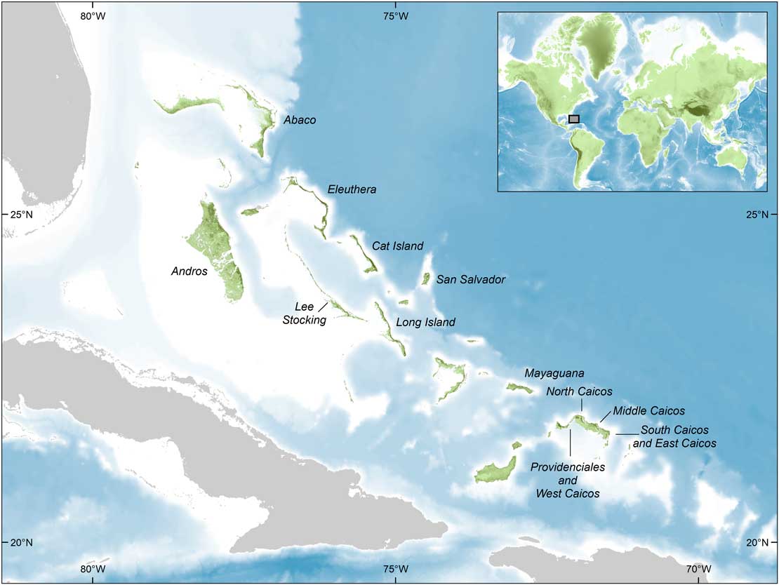
In this paper, we present the results of a program of 87Sr/86Sr measurements on modern trees (primarily Swietania sp. and Guaiacum sp.) from the Bahamas (n=37) and the Turks and Caicos Islands (TCI; n=54; Figure 1). To our knowledge these are the first such data to be reported from the terrestrial biosphere of these islands. The aim is to determine the extent to which modern 87Sr/86Sr measurements are influenced by legacy and ongoing allochthonous inputs, the most important of which is expected to be Saharan dust (others include sea-spray, volcanic ashfall, and dust from the Mississippian loess belt). Our study builds on previous work in the region, and serves in part as a test of the predictions made by Bataille et al.’s (Reference Bataille, Laffoon and Bowen2012) strontium isoscape. Ultimately, the intention is to use these data, in conjunction with other isotopic datasets being produced in the circum-Caribbean, to facilitate studies of the origins and mobility of pre-Columbian humans, animals, and artifacts (Laffoon et al., Reference Laffoon, Davies, Hoogland and Hofman2012, Reference Laffoon, Rodríguez Ramos, Chanlatte Baik, Storde, Rodríguez Lopez, Davies and Hofman2014, Reference Laffoon, Sonnemann, Antczak and Antczak2016, Reference Laffoon, Sonnemann, Shafie, Hofman, Brandes and Davies2017; Ostapkowicz et al., Reference Ostapkowicz, Brock, Wiedenhoeft, Snoeck, Pouncett, Baksh-Comeau, Schulting and Boomert2017). The results may also be of interest to those creating isoscapes in other parts of the world (Evans et al., Reference Evans, Montgomery, Wildman and Boulton2010; Snoeck et al., Reference Snoeck, Pouncett, Ramsey, Meighan, Mattielli, Lee-Thorp and Schulting2016) and to those studying pedogenesis and soil processes using Sr as a tracer for calcium cycling (e.g., Åberg et al., Reference Åberg, Jacks, Wickman and Hamilton1990; Reynolds et al., Reference Reynolds, Quade and Betancourt2012).
(color online) Map of the study region showing the locations of islands sampled in this study. Lee Stocking Island is also identified as providing 87Sr/86Sr results for various reef and mangrove taxa (Reinhardt et al., Reference Reinhardt, Blenkinsop and Patterson1999). Data sources: SRTM Void Filled elevation data courtesy of the U.S. Geology Survey and The GEBCO_2014 Grid, version 20150318 (http://www.gebco.net).

Strontium isotope studies in the circum-Caribbean
Strontium (Sr) is an alkaline earth metal with four naturally occurring isotopes, 84Sr (0.56%), 86Sr (9.86%), 87Sr (7.00%), and 88Sr (82.58%; Faure, Reference Faure1986). The most important of these for provenience studies is 87Sr, deriving from the beta decay of rubidium (87Rb). Thus, the ratio of 87Sr/86Sr will depend on the amount of rubidium originally found in the rock, and the passage of deep time (Faure, Reference Faure1986). In a Caribbean context, young geological formations, such as those of the volcanic arc of the Lesser Antilles, can have 87Sr/86Sr ratios as low as 0.704, while those of older sedimentary and metamorphic formations will have higher ratios of up to 0.715 (e.g., Pushkar et al., Reference Pushkar, Steuber, Tomblin and Julian1973; Borg and Banner, Reference Borg and Banner1996; Laffoon et al., Reference Laffoon, Davies, Hoogland and Hofman2012; Ostapkowicz et al., Reference Ostapkowicz, Brock, Wiedenhoeft, Snoeck, Pouncett, Baksh-Comeau, Schulting and Boomert2017). Most ratios, including those of marine carbonates, fall between these extremes. Strontium becomes incidentally incorporated in lieu of calcium into the tissues of a tree (or other plant) when taken up in solution during the course of the tree’s life (Faure, Reference Faure1986; Capo et al., Reference Capo, Stewart and Chadwick1998). It will therefore reflect the bioavailable 87Sr/86Sr ratio of that location, which, in turn, will be comprised of a combination of Sr from a number of sources, the most important of which will usually be bedrock weathering.
The surface exposures of the Bahamian archipelago (comprising the Bahamas and TCI) are composed entirely of Quaternary limestone, with the most widespread deposits being those of the late Pleistocene Grotto Beach Formation (Marine Isotope Stage 5e) (Carew and Mylroie, Reference Carew and Mylroie1985, Reference Carew and Mylroie1995, Reference Carew and Mylroie1997; Mylroie and Carew, Reference Mylroie and Carew1995; Mylroie et al., 2012; see also Wanless et al., Reference Wanless, Dravis, Tedesco and Rossinsky1989 for TCI), dating to 132–119 ka (Chen et al., Reference Chen, Curran, White and Wasserburg1991). This, in turn, is often overlain by lithified intertidal and aeolian-derived deposits of the Holocene Rice Bay Formation (Mylroie and Carew, Reference Mylroie and Carew1995; Carew and Mylroie, Reference Carew and Mylroie1997). While 87Sr/86Sr ratios exhibit a more or less linear increase over the course of the Pleistocene, no trend is readily apparent for the last 130 ka, during which time ratios do not depart significantly from the contemporary ocean value of ca. 0.70917 (Capo and DePaolo, Reference Capo and DePaolo1990; Hodell et al., Reference Hodell, Mead and Mueller1990; Dia et al., Reference Dia, Cohen, Onions and Shackleton1992; Henderson et al., Reference Henderson, Martel, O’Nions and Shackleton1994; McArthur, Reference McArthur1994), although slightly higher values of ca. 0.70920 have also been reported (Kuznetsov et al., Reference Kuznetsov, Semikhatov and Gorokhov2012). While middle Pleistocene deposits have long been recognized in the Bahamas (Owl’s Hole Formation), they are almost always overlain by late Pleistocene deposits, and are usually exposed only on sea cliffs or in modern road cuts and quarries (Carew and Mylroie, Reference Carew and Mylroie1985, Reference Carew and Mylroie1995; Hearty and Kindler, Reference Hearty and Kindler1993, Reference Hearty and Kindler1997; Hearty, Reference Hearty1998). The Miocene and early Pleistocene deposits recently identified along the north coast of the island of Mayaguana have not yet been recognized elsewhere in the archipelago (Kindler et al., Reference Kindler, Godefroid, Chiaradia, Ehlert, Eisenhauer, Frank, Hasler and Samankassou2011). Strontium isotope ratios on middle Pleistocene (0.34–0.88 Ma) carbonate samples from the island average 0.709155±0.000009 (n=4), significantly lower than the abovementioned late Pleistocene value of ca. 0.70917.
The 87Sr/86Sr ratio of ca. 0.70917 for modern seawater is closely comparable to that observed in a range of marine taxa (gastropods, bivalves, foraminifera, echinoderms, algae, and coral) on Lee Stocking Island, Bahamas, spanning habitats from the coral reefs to mangrove swamps, averaging 0.709179±0.000012 (n=40) and confirming the absence of vital effects, i.e., fractionation (Reinhardt et al., Reference Reinhardt, Blenkinsop and Patterson1999). However, the relationship of bioavailable Sr to the local geology is not always straightforward, especially in terrestrial systems (Sillen et al., Reference Sillen, Hall, Richardson and Armstrong1998; Evans et al., Reference Evans, Montgomery, Wildman and Boulton2010; Hartman and Richards, Reference Hartman and Richards2014; Snoeck et al., Reference Snoeck, Pouncett, Ramsey, Meighan, Mattielli, Lee-Thorp and Schulting2016), being affected by a combination of weathered Sr from the underlying bedrock (Bain and Bacon, Reference Bain and Bacon1994); Sr deposited in rainfall and sea-spray (Vitousek et al., Reference Vitousek, Kennedy, Derry and Chadwick1999; Whipkey et al., Reference Whipkey, Capo, Chadwick and Stewart2000; Montgomery et al., Reference Montgomery, Evans and Neighbour2003; Hodell et al., Reference Hodell, Quinn, Brenner and Kamenov2004; Evans et al., Reference Evans, Montgomery, Wildman and Boulton2010); and Sr in wind-borne dust and soil particles (Prospero et al., Reference Prospero, Glaccum and Nees1981; Reynolds et al., Reference Reynolds, Quade and Betancourt2012). The potential impact of Saharan dust on the Bahamian archipelago’s biosphere is clear from its 87Sr/86Sr ratio of ca. 0.716–0.718 (Grousset and Biscaye, Reference Grousset and Biscaye1989, Reference Grousset and Biscaye2005; Grousset et al., Reference Grousset, Rognon, Coudé-Gaussen and Pédemay1992; Rognon et al., Reference Rognon, Coudé-Gaussen, Revel, Grousset and Pedemay1996), which is considerably higher than that of ca. 0.7092 for late Quaternary limestone. The extent of its impact will depend on the relative amounts of Sr found in these two sources and on their bioavailability.
Saharan dust has been identified as an important contributor to both past and present soils from the Lesser Antilles to Florida, with its strongest expression in the so-called “red soils” that formed during Pleistocene stadials (Delaney et al., Reference Delany, Parkin, Griffin, Goldberg and Reimann1967; Syers et al., Reference Syers, Jackson, Berkheiser, Clayton and Rex1969; Prospero and Nees, Reference Prospero and Nees1986; Prospero et al., Reference Prospero, Nees and Uematsu1987; Muhs et al., Reference Muhs, Crittenden, Rosholt, Bush and Stewart1987, Reference Muhs, Bush, Stewart, Rowland and Crittenden1990; Borg and Banner, Reference Borg and Banner1996; Prospero, Reference Prospero1999; Kamenov et al., Reference Kamenov, Brenner and Tucker2009). Prospero and Mayol-Bracero (Reference Prospero and Mayol-Bracero2013) refer to the Caribbean basin as a major “receptor” site for Saharan dust, which accounts for over half of modern global dust emissions. It has been estimated that some 30 to 50 million tons of Saharan dust falls on the Caribbean annually (Prospero and Carlson, Reference Prospero and Carlson1972; Colcaro et al., Reference Colarco, Toon and Holben2003; Kaufman et al., Reference Kaufman, Koren, Remer, Tanré, Ginoux and Fan2005; see also Prospero et al. Reference Prospero, Nees and Uematsu1987). On the basis of a detailed geochemical study of paleosols from Barbados, the Bahamas, and the Florida Keys, Muhs et al. (Reference Muhs, Bush, Stewart, Rowland and Crittenden1990, p. 171; see also Muhs et al., Reference Muhs, Budahn, Prospero and Carey2007) state that “Saharan dust has been the major parent material for soils on Quaternary limestones of Caribbean and western Atlantic islands in the last 900,000 yr.” Moreover, it is now widely accepted that it is difficult to develop soils on young limestone islands from bedrock dissolution alone, again emphasizing the importance of atmospheric dust sources, including Mississippi River Valley loess, volcanic ash, and Saharan dust (Syers et al., Reference Syers, Jackson, Berkheiser, Clayton and Rex1969; Bricker and Mackenzie, Reference Bricker and Mackenzie1970; Muhs et al., Reference Muhs, Crittenden, Rosholt, Bush and Stewart1987; Reference Muhs, Bush, Stewart, Rowland and Crittenden1990; Boardman et al., Reference Boardman, McCartney and Eaton1995; Prognon et al., Reference Prognon, Cojan, Kindler, Thiry and Demange2011). For the western Caribbean specifically, the contribution of volcanic dust has been shown to be negligible, and, while Mississippian loess may be a minor contributor in the more northern islands, the dominant source is clearly North African dust (Muhs et al., Reference Muhs, Budahn, Prospero and Carey2007).
There have been a number of studies from a range of disciplines employing Sr isotopes in the circum-Caribbean region. Recently, there has been considerable interest from the archaeological community in the use of strontium and other isotopes to trace the provenience of artifacts, animals and people (Laffoon and Hoogland, Reference Laffoon and Hoogland2012; Laffoon et al., Reference Laffoon, Davies, Hoogland and Hofman2012, Reference Laffoon, Rodríguez Ramos, Chanlatte Baik, Storde, Rodríguez Lopez, Davies and Hofman2014, Reference Laffoon, Sonnemann, Antczak and Antczak2016, Reference Laffoon, Sonnemann, Shafie, Hofman, Brandes and Davies2017; Ostapkowicz et al., Reference Ostapkowicz, Naqqi Manco, Richards and Wiedenhoeft2012, Reference Ostapkowicz, Bronk Ramsey, Brock, Cartwright, Stacey and Richards2013, Reference Ostapkowicz, Brock, Wiedenhoeft, Snoeck, Pouncett, Baksh-Comeau, Schulting and Boomert2017; Pestle et al., Reference Pestle, Simonetti and Curet2013). Bataille et al. (Reference Bataille, Laffoon and Bowen2012) have developed a sophisticated Sr isoscape taking into account the contributions of island bedrock geology, differential weathering of rock types, rainfall, and atmospheric dust deposition. However, the availability of biologically available baseline data to validate their model is still spatially patchy. In particular, the model includes no data relating to the terrestrial environment of the Bahamas/TCI.
Here, we present strontium isotope data on 91 modern trees from seven islands spanning some 600 km of the Bahamian archipelago, to assess whether any isotopically distinct allochthonous inputs can be detected. Previous studies have suggested that highly weatherable carbonate bedrock will dominate over the contribution of 87Sr-enriched Saharan dust, though not override it entirely (Bataille et al., Reference Bataille, Laffoon and Bowen2012:13, fig. 5; see also Bern et al., Reference Bern, Townsend and Farmer2005). Thus, the extent of the latter’s potential impact is unclear. While carbonate bedrock will undergo high rates of weathering, in the absence of a developed soil containing clay minerals, this material will not be retained. Balancing this, Saharan dust is an annual input. Furthermore, vegetation itself acts as a dust trap, with subsequent throughfall supplying further aeolian sediments to the soil (Graustein and Armstrong, Reference Graustein and Armstrong1983; Lovett and Lindberg, Reference Lovett and Lindberg1984; Gosz and Moore, Reference Gosz and Moore1989; Åberg et al., Reference Åberg, Jacks, Wickman and Hamilton1990; Reynolds et al., Reference Reynolds, Quade and Betancourt2012).
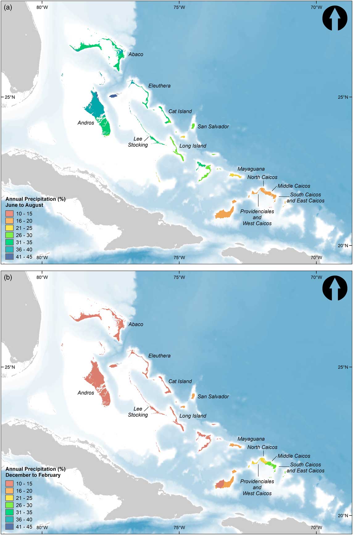
By the time it reaches the Caribbean, deposition of Saharan dust is mainly through wet removal processes, with dust particles acting as cloud condensation nuclei (Nowottnich et al., Reference Nowottnick, Colarco, da Silva, Hlavka and McGill2011). This is particularly relevant to our study in that the Bahamas not only receive substantially higher annual precipitation than TCI (800–1100 mm/yr versus 400–800 mm/yr), but rainfall is concentrated in the summer months in the former, versus the winter months in the latter (Sears and Sullivan, Reference Sears and Sullivan1978; Whitaker and Smart, Reference Whitaker and Smart1997; Fig. 2). Because Saharan dust transport to the Caribbean occurs primarily in the summer months (Prospero et al., Reference Prospero, Glaccum and Nees1981; Prospero, Reference Prospero1999; Goudie and Middleton, Reference Goudie and Middleton2001; Colcaro et al., Reference Colarco, Toon and Holben2003; Prospero and Lamb, Reference Prospero and Lamb2003; Prospero et al., Reference Prospero, Collard, Molinié and Jeannot2014), we might expect the Bahamas to receive higher inputs of Saharan dust than TCI. Counteracting this, and responsible for the opposite trend modeled by Bataille et al. (Reference Bataille, Laffoon and Bowen2012, fig. 5), is the reduced bedrock weathering resulting from lower average rainfall in the southern archipelago (including TCI), but, as acknowledged by the authors, this does not take into account the potential impact of the strong seasonal bias resulting from the combination of summer precipitation and the presence of Saharan dust. There is a clear precipitation gradient even within the Bahamas that is partly captured by our dataset, with Long Island to the south receiving approximately half the rainfall of Cat Island and Eleuthera to the north. This effect increases in the northern Bahamian islands, culminating in Andros, where summer rainfall is twice as high as on Eleuthera. Unfortunately, our study does not include samples from the northern islands. Though the atmospheric dust sources differ from those being considered here, it is worth noting that Gosz and Moore (Reference Gosz and Moore1989) demonstrated a marked seasonal shift in 87Sr/86Sr ratios in precipitation in the mountains of New Mexico. This effect has yet to be demonstrated empirically for our study region, but underlies one of our research questions.
(color online) Percentage of annual precipitation for: (a) summer and (b) winter. Data sources: WorldClim Version 2 (Fick and Hijmans, Reference Fick and Hijmans2017) and The GEBCO_2014 Grid, version 20150318 (http://www.gebco.net).

We test the following hypotheses: (1) Saharan dust will have a small but detectable effect on trees growing on the Bahamian archipelago, raising 87Sr/86Sr ratios above those of the late Quaternary deposits, as modeled by Bataille et al. (Reference Bataille, Laffoon and Bowen2012, fig. 5B). (2) The impact of Saharan dust may exhibit an increasing southeast to northwest gradient, paralleling the summer precipitation gradient, when atmospheric dust of North African origin is also at its peak (thus, we are testing the reverse of the pattern expected from Bataille et al.’s model in this respect, for reasons discussed above). (3) The impact of Saharan dust may be greater in smaller trees with shallower rooting systems, whereas larger trees with deeper rooting systems will be dominated by bedrock 87Sr/86Sr ratios (Reynolds et al., Reference Reynolds, Quade and Betancourt2012; Hartman and Richards, Reference Hartman and Richards2014; though see Poszwa et al. [Reference Poszwa, Dambrine, Ferry, Pollier and Loubet2002] who found that deep roots contributed little or no Sr to trees in a tropical rainforest, but that, instead, there is a focus on the uppermost soils where fine rootlets concentrate to take advantage of nutrients from leaf litter). (4) The impact of Saharan dust may differ according to topography and/or elevation, with less accumulation on ridges as opposed to planes and other low-lying areas and swales (“channels”) having greater potential for the accumulation of dust over recent time as well as tending to be foci for lateritic “red soil” paleosols (Little et al., Reference Little, Buckley, Cant, Henry, Jefferies, Mather, Stark and Young1977, p. 54; Wanless et al., Reference Wanless, Dravis, Tedesco and Rossinsky1989, p. 53). (5) The impact of Saharan dust will be marginally higher in “inland” areas, here defined as lying more than 1 km from the coast, since these are more protected from coastal erosion and so may have greater soil depth. (6) The impact of Saharan dust will be greater in trees growing on clay-rich loams, particularly the “red soils” derived from Saharan dust, than those growing on coral sands.
Note that (5) and (6) are not independent, since the coral sands are primarily coastal though on occasion they do extend “inland” by more than 1km. While the effects in all cases are expected to be small because of the predominant contribution of carbonate bedrock-derived Sr, our relatively large sample size, together with the isotopic homogeneity of the islands’ late Quaternary bedrock deposits, should enable us to detect even slight shifts towards higher 87Sr/86Sr ratios, should they exist. Thus, the Bahamian archipelago is well-suited for testing the potentially subtle effects of Saharan dust on 87Sr/86Sr ratios in living vegetation growing over carbonate bedrock in the western Caribbean.
MATERIALS AND METHODS
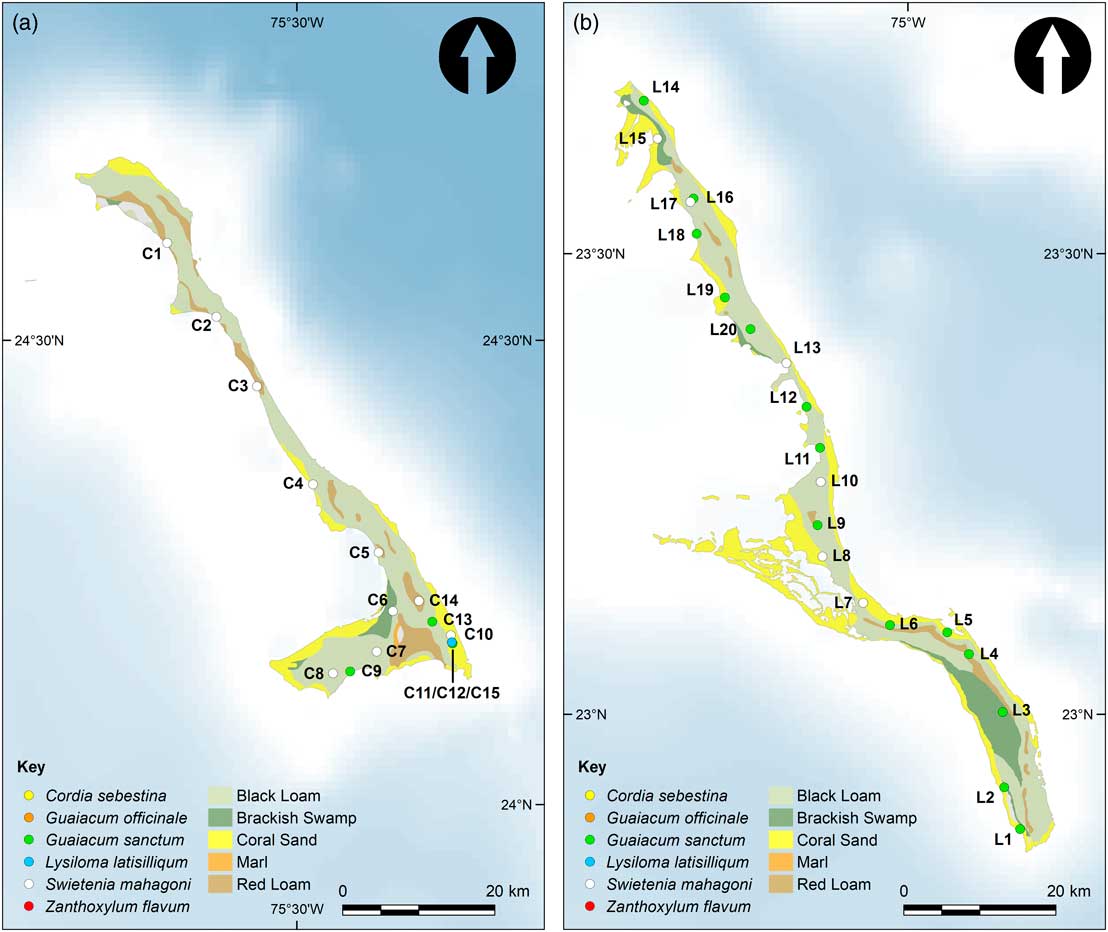
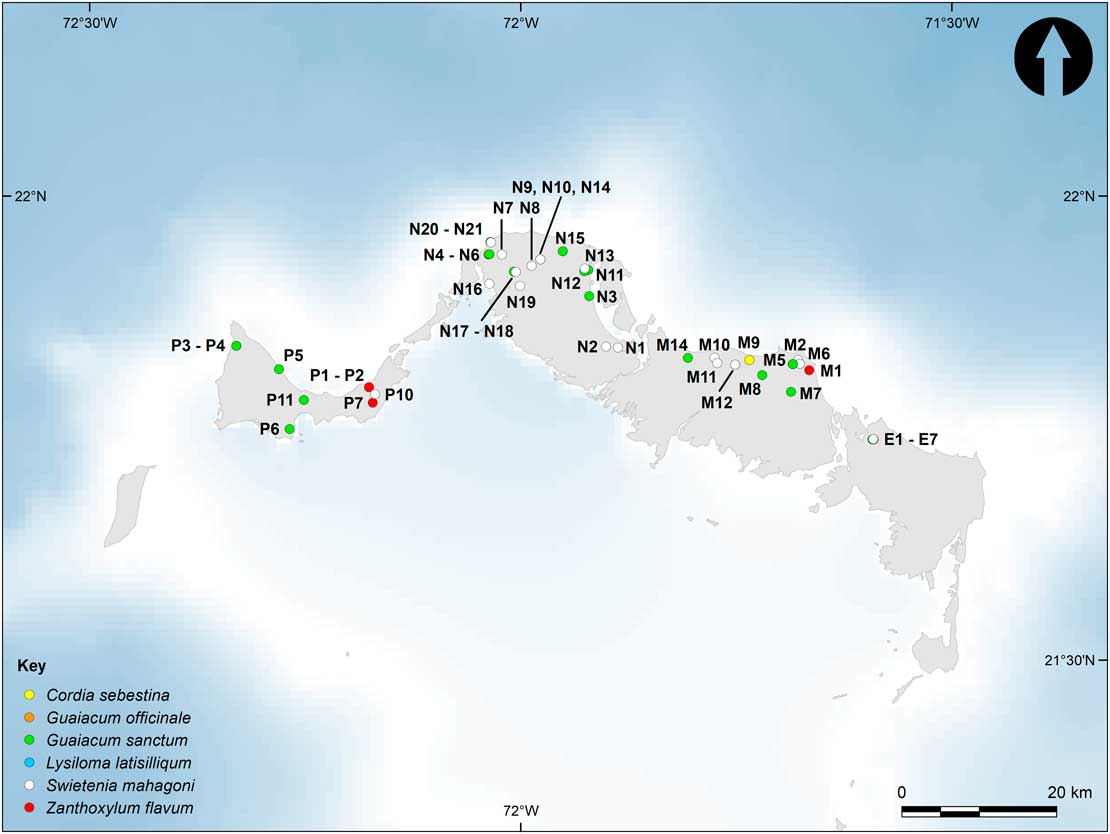
Ninety-one samples from living trees were collected in 2009 from Eleuthera (n=2), Cat Island (n=15), and Long Island (n=20) in the Bahamas, and from Providenciales (n=12) and North (n=21), Middle (n=14), and East Caicos (n=7) in TCI (Fig.1, 3–4). The majority of the samples collected were of Guaiacum sanctum (n=44) and Swietenia mahagoni (n=36), since these taxa have been identified as among the most commonly used for pre-Columbian woodcarvings in the Bahamas and TCI (Ostapkowicz et al., Reference Ostapkowicz, Naqqi Manco, Richards and Wiedenhoeft2012; Ostapkowicz, Reference Ostapkowicz2015). Smaller numbers of samples of G. officinale (n=4), Zanthoxylum flavum (n=4), Cordia sebestina (n=2), and Lysiloma latisiliquum (n=1) were also collected; these species are also known to have been used in pre-Columbian woodcarving. One of the original aims of this project was to develop baseline data for the interpretation of 87Sr/86Sr ratios obtained on these artifacts (Ostapkowicz et al., Reference Ostapkowicz, Naqqi Manco, Richards and Wiedenhoeft2012), and using the same taxa for the modern study removed a potentially confounding variable. Guaiacum and Swietenia are CITES-listed (Convention on International Trade in Endangered Species), and the project fully complied with all regulations pertaining to the documentation and export/import of specimens (CITES permit nos. 2009/356 [Bahamas] and PLS-W-2009-39, 417091/01 [Turks and Caicos]). As part of the agreement with the national agencies, botanical specimens were collected from the same trees, and were dried and prepared for herbarium collections in national institutions in the Bahamas and TCI, with another archive held in the World Museum Liverpool. Field sampling was undertaken with botanists from the National Trusts of the Bahamas (EF) and Turks and Caicos Islands (BNM), who provided field identifications of species.
(color online) The distribution of the main soils and sample locations for: (a) Cat Island and (b) Long Island. Data sources: Soils of the Bahama Islands (Mooney, Reference Mooney1905) and The GEBCO_2014 Grid, version 20150318 (http://www.gebco.net).

(color online) Caicos Islands, Turks and Caicos, showing sample locations. Sampling on North, Middle and East Caicos is concentrated along the north coasts due to the absence of trees on the swampland and tidal flats of the southern half of the islands. Data source: The GEBCO_2014 Grid, version 20150318 (http://www.gebco.net).

Potentially relevant is the rooting depth of these genera—among the largest indigenous trees on the islands—which could tap into the rare deeper soils that include aeolian inputs accumulated over decades or more, or, alternatively, beneath the shallow soil horizon entirely into carbonate bedrock, whereas shallow-rooting plants might predominantly reflect leaf litter and more recent inputs over the last few years. However, over-harvesting of Guaiacum and Swietenia in the seventeenth to nineteenth centuries has left few surviving groves in the Bahamas and TCI (Correll and Correll, Reference Correll and Correll1982, p. 26). Most are found in what is known locally as “coppice” wood, and many take the form of bushes rather than full size trees. In any case, a study by Pozwa et al. (Reference Poszwa, Dambrine, Ferry, Pollier and Loubet2002) suggests that in nutrient-poor soils, which certainly describe the Bahamian archipelago, Sr uptake will focus on the near-surface layer. Moreover, soils across the study region are generally thin, often only a few centimeters over bedrock, though some solution holes (“banana holes”) have become infilled to depths of a few meters (Mooney, Reference Mooney1905; Little et al., Reference Little, Buckley, Cant, Henry, Jefferies, Mather, Stark and Young1977).
Once a grove or individual tree was identified, GPS coordinates and detailed information on tree size and environment were documented, and each sampled tree was photographed. Twigs of ca. 1 cm in diameter were taken from trees ranging in height from ca. 1 to 12 m (averaging ca. 4.1±2.0 m), and from ca. 0.05 to 0.5 m in diameter at chest height (averaging ca. 0.25±0.10 m). Only the branchwood was used for Sr isotope analysis, and so reflects growth over a period of 2–4 yr. For the purposes of analysis, trees were divided into three size classes: small (0.05–0.20 m diameter at chest height, 1.0–3.0 m height), medium (0.20–0.40 m diameter, 3.0–5.0 m height) and large (>0.40 m diameter,>5.0 m height). Appropriate size information was recorded for 86 trees (measurements for five trees were not recorded).
Collection sites were chosen to provide wide coverage of the selected islands (which were themselves chosen based on the known presence of the target tree species) to investigate possible subtle differences in Sr isotope ratios, e.g., between coast and interior, defined as <1 km and>1 km from the coast, respectively, and between landforms. This coast-inland division was chosen primarily because transects on both the west and east coasts of Ireland suggest that the effects of sea-spray on 87Sr/86Sr ratios in the biosphere do not extend past 1 km on carbonate bedrock (Snoeck, Reference Snoeck2014). This is in contrast to other studies reporting stronger and more widespread impacts of sea-spray and/or rainfall (Vitousek et al., Reference Vitousek, Kennedy, Derry and Chadwick1999; Whipkey et al., Reference Whipkey, Capo, Chadwick and Stewart2000; Montgomery et al., Reference Montgomery, Evans and Neighbour2003; Hodell et al., Reference Hodell, Quinn, Brenner and Kamenov2004), but these studies refer to regions dominated by basaltic or granitic bedrocks that are far more resistant to weathering than limestone, and so are more readily affected by allochthonous inputs (cf. Bataille et al., Reference Bataille, Laffoon and Bowen2012).
Morphometric characterization of landform at the sample locations was carried out using 1 arc second (ca. 30 m at the equator) Shuttle Radar Topography Mission (SRTM) void-filled digital elevation model (https://lta.cr.usgs.gov/SRTMVF) in Landserf 2.3.1 (Wood, Reference Wood2009). Cells in a digital elevation model can be classified as pits, channels, passes, ridges, peaks, or planes using unique criteria based on four surface parameters: slope, cross-sectional curvature, maximum curvature, and minimum curvature (Wood, Reference Wood1996). Surface parameters are calculated using quadratic approximation, fitting a quadratic trend surface through all of the data points corresponding to the cells in an n×n window and calculating the values of the parameters for the cell at its center. The values of the surface parameters and the subsequent characterization of the morphometric feature types are scale dependent, i.e., dependent on the size of the n×n window. Multi-scalar characterization can be performed by calculating fuzzy feature classes, with values for each morphometric feature type ranging between 0 (not classified as that feature type at any scale of analysis) and 1 (classified as that feature type at all scales of analysis). Fuzzy feature classes were calculated for the Bahamas and Turks and Caicos Islands for window sizes between 3 and 31, equivalent to planimetric distances of between ca.100 m and ca.1 km. Dominant feature types for the sample locations were determined on the basis of the fuzzy feature class with the highest value (ridges, n=11; planes, n=74; and channels, n=3). The fuzzy feature classes for the sample locations were also reclassified as negative features (pits>0 or channels>0 or passes>0) or positive features (ridges>0 or peaks>0) in order to determine locations where sediments were likely to accumulate and locations where erosion was likely to have occurred (negative, n=21; and positive, n=35)Footnote 1 .
We have soil maps only for Long and Cat Islands (we have been unable to source any from TCI), and have plotted sampling locations against areas identified as Bahama Black Loam (n=18), Bahama Red Loam (n=5), Coral Sands (n=10), and Brackish Swamp (n=2) (Mooney, Reference Mooney1905; Fig. 5). Field observations suggest that the two locations on what were identified as “Brackish Swamp” in the early twentieth century may have since been drained as part of now largely abandoned attempts to improve soil fertility for agriculture (Little et al., 1997). The designation is retained here, since there may be a legacy effect on these soils. The lateritic clay-rich “Red Loam” represents exposed Pleistocene paleosols with high concentrations of Saharan dust. They can range in color from deep red (Munsell 10Y 2/2) to light yellow-brown (10YR 7/6), mainly reflecting diagenetic processes (Foos and Bain, Reference Foos and Bain1995). Unfortunately, these are the least well-represented in our study, since testing soil differences was not an original aim of the project. Nevertheless, because Saharan dustfall is an annual input, its contribution might be reasonably expected to feature in all soils to some extent (Prospero and Carlson, Reference Prospero and Carlson1972; Colcaro et al., Reference Colarco, Toon and Holben2003; Kaufman et al., Reference Kaufman, Koren, Remer, Tanré, Ginoux and Fan2005; Prospero and Mayol-Bracero, Reference Prospero and Mayol-Bracero2013). The contribution of Saharan dust to other soils in the Bahamas is confirmed by its presence in trace amounts even in coral sands (Foos and Bain, Reference Foos and Bain1995). Furthermore, the relatively organic-rich “black soils” that dominate our sampling locations—in addition to containing the Sr taken up by decomposing plants during life—should also trap and hold the Saharan dust that continues to fall each summer. This is because strontium cations (Sr2+) will be relatively strongly adsorbed onto negatively charged clay minerals and organic matter (Capo et al., Reference Capo, Stewart and Chadwick1998, pp. 201, 208). Indeed, pre-Holocene peat samples from San Salvador and Andros were found to contain significant amounts of boehmite, a marker for Saharan dust (Boardman et al., Reference Boardman, McCartney and Eaton1995, p. 44), clearly demonstrating that the latter’s impact is not restricted to the “red soils.”
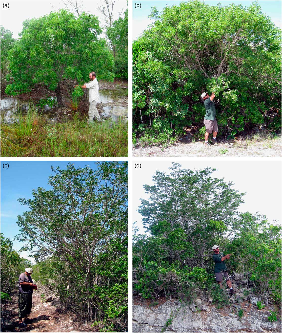
(color online) (a) Small Swietenia mahagoni growing on flooded “Bahama Black Loam,” south of Old Bight, Cat Island (C7). (b) Medium Swietenia mahagoni growing on “Coral Sand,” Hamilton’s, Long Island (L7). (c) Medium Guaiacum sanctum growing on yellow-brown loam, Lorimer’s, Middle Caicos (M7). (d) Small Guaiacum sanctum bush growing on shallow “Bahama Red Loam,” south of Scrub Hill, Long Island (L6).

A caveat in terms of the application of our findings to the pre-Columbian period is that the soils of the Bahamian archipelago have been heavily eroded following deforestation in the early Colonial period and so may not fully reflect the earlier situation. The transport of Saharan dust over the Caribbean has also varied over time, particularly as a result of precipitation over the Sahel and of the strength of winds over the dust source regions (Prospero and Lamb, Reference Prospero and Lamb2003; Ridley et al., Reference Ridley, Heald and Prospero2014). Nevertheless, data from 2002–2011, encompassing sample collection in July 2009, shows that these years all recorded substantial summer Saharan dustfall in the Caribbean (Prospero et al., Reference Prospero, Collard, Molinié and Jeannot2014, fig. 7).
Strontium isotope analysis
Branchwood samples were prepared for Sr isotope analysis following methods outlined in Reynolds et al. (Reference Reynolds, Betancourt, Quade, Patchett, Dean and Stein2005). Samples ranging in size from 20 to 100 mg were first cleaned in ultrapure water and then ashed at 850°C before being prepared following standard Sr isotope preparation procedures and measurement using a ThermoFinnigan Neptune Inductively-Coupled Plasma Multi-Collectors Mass Spectrometer (MC-ICP-MS) at the Department of Human Evolution, Max Planck Institute of Evolutionary Anthropology, Leipzig, Germany (see details in Copeland et al., Reference Copeland, Sponheimer, le Roux, Grimes, Lee-Thorp, de Ruiter and Richards2008). For quality assurance, measurements runs included the international Standard Reference Material (SMR) 1486, and samples were corrected using the SRM 987 strontium carbonate isotopic standard (https://www.nist.gov/srm). Measurement errors are on the order of±0.00003, based on long-term repeat analyses of SRM 1486 at the Max Planck Institute.
Statistical tests were carried out in SPSS. Data were assessed for normality and parametric or nonparametric tests were applied as appropriate (the latter were not required). Heteroscedastic tests were applied in cases when variance was not homogeneous.
RESULTS
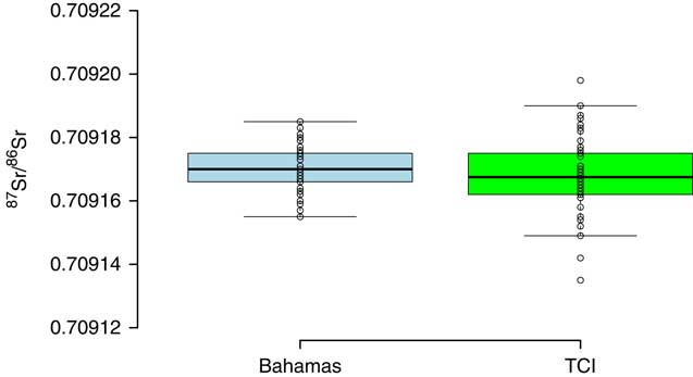
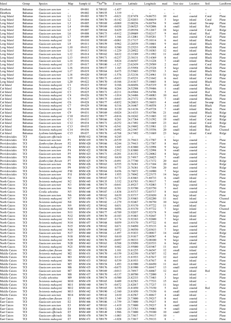
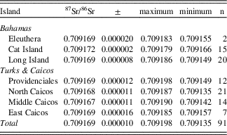
The 87Sr/86Sr isotope ratios obtained on 91 samples are extremely homogeneous, with a mean of 0.709169±0.000010 and a coefficient of variation of only 0.001% (Tables 1 and 2; Fig. 6). The data are normally distributed (Shapiro-Wilk test, W=0.983, P=0.295), with only four samples lying more than two standard deviations from the mean (see Z-scores in Table 1); this is approximately what would be expected given the sample size.
(color online) Box plot (central horizontal line=median; shaded box=interquartile range (IQR); whiskers=1.5×IQR) of the 87Sr/86Sr ratios from the Bahamas and TCI. Created in BoxPlotR (Spitzer et al., Reference Spitzer, Wildenhain, Rappsilber and Tyers2014).

87Sr/86Sr results and metadata for sampled modern trees from the Bahamas and TCI.

Summary statistics for 87Sr/86Sr results by island.

In terms of the hypotheses set out in the paper: (1) There is no detectable 87Sr-enrichment as a result of Saharan dust, as the overall mean of 0.709169±0.000010 is indistinguishable to five decimals places from modern seawater (Hodell et al., Reference Hodell, Mead and Mueller1990; Dia et al., Reference Dia, Cohen, Onions and Shackleton1992; Henderson et al., Reference Henderson, Martel, O’Nions and Shackleton1994; McArthur, Reference McArthur1994).
(2) There is no difference between the means of the island groups, with the Bahamas averaging 0.709170±0.000007 (n=37) and TCI averaging 0.709168±0.000012 (n=54) (heteroscedastic Student’s t-test, t=0.96, P=0.34). However, the TCI results are significantly more variable (F-test, F=2.46, P=0.005), including the four highest and seven lowest measurements in the dataset (Fig. 6). There are no differences in the means of the individual islands independent of island group (ANOVA, F=0.31, P=0.93, df=6, 83). Together, these two tests also act as a proxy for assessing the postulated positive relationship with summer precipitation, for which no evidence is seen. This also tests for the east to west pattern of decreasing impact of Saharan dust modeled by Bataille et al. (Reference Bataille, Laffoon and Bowen2012), and, again, no such trend can be observed.
(3) There is no difference between the three tree size classes (ANOVA F=0.18, P=0.84, df=2, 83). No difference between tree species was anticipated, since samples from the two main species targeted each reflect the full range of tree size and so would be expected to have similar rooting depth, nor do they have different habitat requirements, and indeed are sometimes found growing near one another (e.g., Figure 3b, samples L16 and L17). The lack of any effect in this regard was confirmed (ANOVA, F=1.07, P=0.36, df=3, 84).
(4) There is no difference by topographical location (planes, ridges and channels, ANOVA, F=0.34, P=0.71, df=2, 85; negative and positive positions, Student’s t-test, t=1.17, P=0.25, df=54), or elevation (linear regression model, R 2=0.00, P=0.52, n=88).
(5) There is no difference between coastal (n=49, defined as within 1 km of the coast) and “inland” locations (n=39), as far as the latter can be said to exist on the small, low-lying islands of the archipelago (Student’s t-test, t=1.14, P=0.26, df=86).
(6) No differences are seen between the four recorded Bahamian soil types (Bahamas Black Loam, Bahamas Red Loam, Coral Sand, and Brackish Swamp), which are all identical to five decimals with the overall average of 0.70917 (ANOVA, F=0.42, P=0.74, df=3, 31). Two samples from Middle Caicos (M7 and M12 in Table 1), noted in the field as growing on reddish/yellow-brown soils have ratios of 0.709169 and 0.709165, respectively, at and slightly below the average both for Middle Caicos and for all islands combined.
DISCUSSION
The 87Sr/86Sr taken up by trees across the Bahamas and TCI is consistent with an entirely autochthonous origin. A caveat here is the expected contribution of Sr in sea-spray, which affects the 87Sr/86Sr ratios of both soils and plants along the coasts of many Caribbean islands (Bataille et al., Reference Bataille, Laffoon and Bowen2012; Laffoon et al., Reference Laffoon, Davies, Hoogland and Hofman2012; Pestle et al., Reference Pestle, Simonetti and Curet2013). This will not be detectable in the Bahamian archipelago, however, since the value for sea-spray will be indistinguishable from that of the islands’ late Quaternary limestone bedrock (cf. Borg and Banner, Reference Borg and Banner1996). Furthermore, in Sr-rich carbonate formations (ca. 610 ppm), seawater (7–8 ppm) is not expected to be a significant factor (Faure, Reference Faure1986; Angino et al., Reference Angino, Billings and Andersen1996; Borg and Banner, Reference Borg and Banner1996; see also Snoeck, Reference Snoeck2014). Rainfall is more complicated, since in the summer months it will contain Saharan dust particles, and so have a combination of Sr from both seawater and dust sources, though the concentration of Sr in precipitation is orders of magnitude less than in seawater (<0.1 ppm; Faure, Reference Faure1986; Capo et al., Reference Capo, Stewart and Chadwick1998) apart from dust nuclei (200–300 ppm; Grousset et al., Reference Grousset, Rognon, Coudé-Gaussen and Pédemay1992; Rognon et al., Reference Rognon, Coudé-Gaussen, Revel, Grousset and Pedemay1996; Grousset and Biscaye, Reference Grousset and Biscaye2005). Therefore, precipitation on its own will not be a significant contributor of Sr.
More noteworthy for the present discussion is the absence of evidence for any measureable input in the overall dataset from atmospheric dust sources with different 87Sr/86Sr ratios, whether lower ratios from volcanic ashfalls (ca. 0.707), or higher ratios from Saharan dust (ca. 0.716–0.718; Grousset et al., Reference Grousset, Rognon, Coudé-Gaussen and Pédemay1992; Kroma et al., Reference Kroma, Cliff, Eijsink, Herut and Chester1999; Grousset and Biscaye, Reference Grousset and Biscaye2005; Formenti et al., Reference Formenti, Schutz, Balkanski, Desboeufs, Ebert, Kandler, Petzold, Scheuvens, Weinbruch and Zhang2011; Aarons et al., Reference Aarons, Aciego and Gleason2013). Even if present in only small amounts, either should have a discernable impact on the observed ratio for modern trees of 0.70917. For example, using a value of 0.71788 for Saharan dust (Bataille et al., Reference Bataille, Laffoon and Bowen2012, p. 7), a contribution of only 0.5% would raise the 87Sr/86Sr ratio by over four standard deviations above the average of 0.70917 obtained for trees growing in the Bahamas/TCI in this project.
As might be expected given the striking homogeneity of our dataset, no convincing evidence could be found for even slight effects of Saharan dust or volcanic ashfalls on islands with greater summer dust-carrying rainfall, in “inland” versus coastal locations, in different topographic positions, or on different soils, including a small number growing on lateritic “red soils” (Fig. 5). The only statistically significant difference that was observed relates to the greater variability in 87Sr/86Sr ratios on TCI compare to the Bahamas. While it is conceivable that a small amount of volcanic ashfall is responsible for the lower ratios, we find this improbable based on previous studies addressing this issue (Muhs et al., Reference Muhs, Budahn, Prospero and Carey2007). Alternatively, it may be that these particular trees were growing on soils derived in part from middle Pleistocene deposits with lower 87Sr/86Sr ratios (Hodell et al., Reference Hodell, Mead and Mueller1990; Kindler et al., Reference Kindler, Godefroid, Chiaradia, Ehlert, Eisenhauer, Frank, Hasler and Samankassou2011). Unfortunately, as noted above, we have no detailed geological maps for TCI and thus are unable at present to address this matter further. Furthermore, detailed surficial geological mapping on the Bahamas, and by extension TCI, is extremely difficult due to the spatial patchiness of original deposition and subsequent uneven erosion (Carew and Mylroie, 1992). At the upper end of the 87Sr/86Sr range, there are only two samples more than two standard deviations above the mean, which is in keeping with what would be expected from measurement error alone given our sample size. There is no need, therefore, to invoke any impact of Saharan dust to explain these outliers.
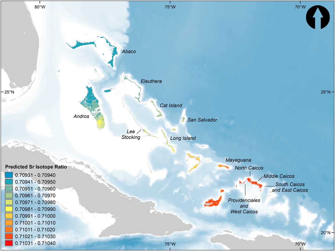
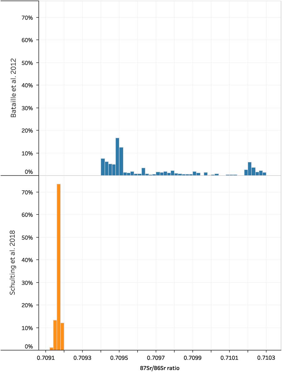
The results reported here for 91 modern trees fall well outside the predicted range of 87Sr/86Sr ratios (0.70937–0.71030) for the Bahamas and Turks and Caicos Islands from Bataille et al. (Reference Bataille, Laffoon and Bowen2012, fig. 5B; raster dataset available from http://waterisotopes.org; Bowen, Reference Bowen2017; Fig.7 and 8). The predicted values are based on a three-source mixing model, which takes into account weighted inputs from bedrock weathering, atmospheric mineral dust, and sea salt. Whilst the weighting of the inputs varies spatially, the 87Sr/86Sr ratios for bedrock (0.7080; Bataille and Bowen, Reference Bataille and Bowen2012), mineral dust (0.71788, mean of mineral dust collected over the Caribbean region; Grousset and Biscaye, Reference Grousset and Biscaye2005; Formenti et al., Reference Formenti, Schutz, Balkanski, Desboeufs, Ebert, Kandler, Petzold, Scheuvens, Weinbruch and Zhang2011) and sea salt (0.7092, mean of bulk seawater) are constant. The value of 0.7080 used for bedrock in the model is based on the U.S. Geological Survey map of the Caribbean region (French and Schenk, Reference French and Schenk2004), which characterizes the surface geology of the Bahamas and Turks and Caicos Islands as “Quaternary alluvium,” and is given this ratio using the analogous descriptor from Bataille and Bowen (Reference Bataille and Bowen2012). However, this ratio is inappropriate for the islands’ late Quaternary marine carbonate bedrock with a value to four decimals of 0.7092.
(color online) Predicted Sr isotope rations for the circum-Caribbean region from the three-source mixing model (after Bataille et al., Reference Bataille, Laffoon and Bowen2012, Figure 5B). Data sources: Circum-Caribbean Sr isotopes (Bowen, Reference Bowen2017; Lehnert et al., Reference Lehnert, Su, Langmuir, Sarbas and Nohl2000) and The GEBCO_2014 Grid, version 20150318 (http://www.gebco.net).

(color online) Histograms showing the difference between the modeled 87Sr/86Sr isotope ratios for the Bahamian archipelago from Bataille et al. (Reference Bataille, Laffoon and Bowen2012), based on a three-source mixing model, which over-estimates the contribution of Saharan dust, and the results obtained on modern trees in this paper.

Given the erroneously low 87Sr/86Sr ratio of bedrock and the equivalence of ratios for sea salt and plant samples in the present study, the model significantly overestimates the input of mineral dust. The potential sources of error in the predicted Sr isoscape for the circum-Caribbean region, not least those resulting from the resolution of the surface geology database and the uncertainties of modeling aerosol deposition, are acknowledged by Bataille et al. (Reference Bataille, Laffoon and Bowen2012), who were exploring large-scale regional patterning and so were primarily interested in modeling broad trends. No 87Sr/86Sr measurements were available for the Bahamas and Turks and Caicos Islands to validate their model at the time. Even at the broad scale at which it is intended to apply, the measured ratios for plant samples in the present study indicate that the model is a poor fit for the Bahamian archipelago. That the predicted range of 0.709–0.710 actually encompasses our observed value of 0.70917 is fortuitous given the use of an inappropriate bedrock value of 0.7080. Substituting a more accurate 87Sr/86Sr bedrock ratio of 0.7092 would have resulted in even higher predicted ratios for our study area, far above what was observed.
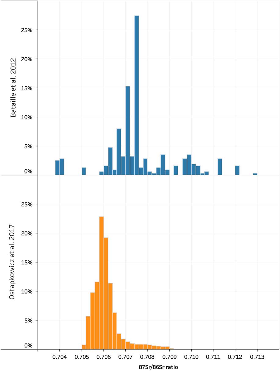
The recent publication of a Sr isoscape for Trinidad and Tobago, again based on measurements of modern trees (Ostapkowicz et al., Reference Ostapkowicz, Brock, Wiedenhoeft, Snoeck, Pouncett, Baksh-Comeau, Schulting and Boomert2017, fig. 11), provides an additional test of the predictions made in Bataille et al.’s (Reference Bataille, Laffoon and Bowen2012; cf. Laffoon et al., Reference Laffoon, Sonnemann, Antczak and Antczak2016) model. We focus here on Tobago, since it has a simpler geology, being part of a Cretaceous volcanic arc, with a zone of Pleistocene marine deposits confined to the south of the island (Frost and Snoke, Reference Frost and Snoke1989; French and Schenk, Reference French and Schenk2004). Moreover, the bedrock 87Sr/86Sr values for the volcanic arc are low (0.7038±0.0005, n=18; data from Frost and Snoke, Reference Frost and Snoke1989, table 3), so that any influence of Saharan dust should be readily apparent. In this case there does appear to be a significant impact from marine sources (sea-spray and precipitation) and/or Saharan dust (bioavailable 87Sr/86Sr excluding the limestone region: 0.7058±0.0010, n=17; data from Ostapkowicz et al., Reference Ostapkowicz, Brock, Wiedenhoeft, Snoeck, Pouncett, Baksh-Comeau, Schulting and Boomert2017, table 3). The predicted ratios of between 0.7049 and 0.7096 for Tobago in Ostapkowicz et al.’s (2017) new isoscape (with the high end of this range confined to the Pleistocene marine deposits of the southwest end of the island) are at the lower end of the range predicted by Bataille et al.’s (Reference Bataille, Laffoon and Bowen2012, fig. 5B) model (0.7038 to 0.7129, with the low values restricted to a very small part of the island; raster dataset available from http://waterisotopes.org; Bowen, Reference Bowen2017; Fig. 9). This is particularly noteworthy in that the bedrock geology across most of Tobago is much more resistant to weathering than marine carbonates, and so a correspondingly greater contribution from allochthonous sources would be expected (Bataille et al., Reference Bataille, Laffoon and Bowen2012, fig. 6B).
(color online) Histograms showing the difference between the modeled 87Sr/86Sr isotope ratios for Tobago from Bataille et al. (Reference Bataille, Laffoon and Bowen2012), based on a three-source mixing model, which over-estimates the contribution of Saharan dust, and Ostapkowicz et al. (Reference Ostapkowicz, Brock, Wiedenhoeft, Snoeck, Pouncett, Baksh-Comeau, Schulting and Boomert2017), based on Empirical Bayesian Kriging of measured values from modern plant samples.

Accepting that Saharan dust contributes significantly to the soils of the Bahamas/TCI, why do we not see any impact on strontium isotope ratios in the biosphere? Bataille et al. (Reference Bataille, Laffoon and Bowen2012) emphasize the importance of taking airborne mineral dust into account, but note that its contribution is variable across the circum-Caribbean, decreasing from east to west, and is also dependent on the bedrock substrate of the island in question, in relation to both its susceptibility to erosion and the amount of Sr it contains. While the marine carbonates of the Antilles and the Bahamian archipelago can be characterized as highly weatherable, they leave little material behind when they enter solution, and simply wash away (Borg and Banner, Reference Borg and Banner1996). This is why researchers emphasize the difficulty of developing soils on limestone islands, since they contain relatively few other minerals besides CaCO3. They are Sr-rich, however, and so will contribute in an ongoing fashion to the pool of biologically available Sr on the islands.
Central to the discussion is not only the relative Sr concentrations in limestone and in Saharan dust, and their respective 87Sr/86Sr ratios, but also the bioavailability of Sr. As already noted, the 87Sr/86Sr value of late Quaternary deposits in the Bahamian archipelago is tightly constrained to ~0.7092. Carbonates have some of the highest Sr concentrations found in rock, on the order of 610 ppm (Faure, Reference Faure1986; Capo et al., Reference Capo, Stewart and Chadwick1998). The Sr concentration of Saharan dust has been variously reported as being from one-half (286±58 ppm; Grousset et al., Reference Grousset, Rognon, Coudé-Gaussen and Pédemay1992) to one-third of this (195 ppm; Rognon et al., Reference Rognon, Coudé-Gaussen, Revel, Grousset and Pedemay1996; Grousset and Biscaye, Reference Grousset and Biscaye2005). The more recent latter figure is used in Bataille et al.’s (Reference Bataille, Laffoon and Bowen2012:7) isoscape model. Saharan dust is highly radiogenic in a Caribbean context, with an 87Sr/86Sr value of ca. 0.71788 (Grousset and Biscaye, Reference Grousset and Biscaye1989, Reference Grousset and Biscaye2005; Grousset et al., Reference Grousset, Rognon, Coudé-Gaussen and Pédemay1992; Formenti et al., Reference Formenti, Schutz, Balkanski, Desboeufs, Ebert, Kandler, Petzold, Scheuvens, Weinbruch and Zhang2011). This refers to the bulk measurement of airborne dust particles, however, much of which (>70%) will take the form of the clay minerals mica-illite and kaolinite with decreasing amounts of quartz with distance from the source (Glaccum and Prospero, Reference Glaccum and Prospero1980; see also Caquineau et al., Reference Caquineau, Gaudichet, Gomes and Legrand2002). Strontium associated with mica and especially quartz will not be readily bioavailable due to the relatively low solubility of these minerals (Rummel et al., Reference Rummel, Hoelzl, Horn, Rossmann and Schlicht2010, p. 892). Concentrations of highly soluble calcite, on the other hand, were found to be a minor component at consistently less than 10% (Glaccum and Prospero, Reference Glaccum and Prospero1980). Aarons et al. (Reference Aarons, Aciego and Gleason2013, fig. 2) separated the soluble and insoluble fractions for 87Sr/86Sr measurements of Saharan dust collected in a North Atlantic transect. They found that the soluble fraction was invariably less radiogenic (0.7108) than the insoluble silicate fraction (0.7159), attributing this to the former’s dilution with sea-salt, unsurprising given the use of shipboard collection filters. The point to be made here is that the dust included strontium in its insoluble fraction, which would not be readily bioavailable.
Thus, the bioavailability of Sr in Saharan dust is unclear. As noted above, Sr2+ will be adsorbed onto negatively charged clay minerals and organic matter (Capo et al., Reference Capo, Stewart and Chadwick1998). In this sense Sr would be held in the soil, but once adsorbed it would need to desorb as part of the soil exchange process before becoming available to be taken up by plant roots. Studies have shown that both clay and organic matter inhibit the transfer of soil Sr to plants (Baes et al., Reference Baes, Garten, Taylor and Witherspoon1986; Lembrechts, Reference Lembrechts1993). Other complicating factors include the presence of competing ions in the soil (e.g., Na2+), the concentration ratio of Sr to other micro- and macro-nutrients, and microenvironments (including ion depletion) created in the rooting zone by the plants themselves, all of which combine to render the concept of “bioavailability” difficult to operationalize within a given context (Ehlken and Kirchner, Reference Ehlken and Kirchner2002). To this can be added the relationship between the timing of dustfall and the growing season.
The empirical results presented in this paper differ substantially from the predictions made by the current Sr isotope model for the Caribbean, which, while noting the dominance of bedrock weathering to the bioavailable Sr flux in carbonate regions such as those of the Bahamian archipelago, nevertheless still predicts a 20–30% contribution of atmospheric dust sources in the southern archipelago, decreasing to 10–20% in the north (Bataille et al., Reference Bataille, Laffoon and Bowen2012, fig. 5A). Our results suggest that the contribution of airborne dust to the Sr flux is considerably lower than this, and is in fact undetectable in a comparatively large sample of 91 measurements. It is still necessary, however, to sample a greater range of terrestrial vegetation than we have done here, including grasses, before concluding that there is absolutely no effect on the islands’ biosphere, with the further implication of little to no impact of Saharan dust on 87Sr/86Sr ratios in the biosphere in other carbonate regions of the Caribbean, including Florida.
CONCLUSIONS
Our results suggest that Saharan dust does not make a significant contribution to bioavailable Sr in the Bahamian archipelago, and that bedrock is the main driver. The contribution of sea-spray is not detectable isotopically because of the near-equivalence of modern ocean and late Quaternary carbonate 87Sr/86Sr ratios, though the much higher Sr concentration of the latter means that this source will be overwhelmingly dominant in any case. Our results support the proposition that highly weatherable carbonate bedrock will override the influence of North African dust, though the full extent of this was previously not clear. For the 91 trees in our study, we found over an order of magnitude less influence of Saharan dust than predicted by Bataille et al.’s (Reference Bataille, Laffoon and Bowen2012) Sr isoscape. Similarly, a Sr isoscape recently created for Trinidad and Tobago (Ostapkowicz et al., Reference Ostapkowicz, Brock, Wiedenhoeft, Snoeck, Pouncett, Baksh-Comeau, Schulting and Boomert2017) suggests a lower contribution of Saharan dust to Tobago’s biosphere than predicted by Bataille et al.’s model.
The impact of Saharan dust on bioavailable 87Sr/86Sr ratios in the Caribbean and elsewhere needs to be revisited, potentially reducing its significance for ecological and archaeological provenience studies in the biosphere and underlining the need to tailor isoscapes to individual contexts (cf. Wunder, Reference Wunder2010, pp. 251–252). The extent to which the findings in the present study apply to other parts of the circum-Caribbean region and further afield would benefit from further investigation. Even within the Bahamian archipelago, a study focused more specifically on the “red soils” is needed, in order to determine the extent to which these soils can be distinguished isotopically from the other soils of the islands. Similarly, the impact of seawater as an allochthonous input would be more appropriately investigated by targeting vegetation growing on the limited exposures of early and middle Pleistocene deposits. We intend to address these matters in the future.
ACKNOWLEDGMENTS
This research was supported by a grant from the Getty Foundation and by the Max Planck Institute. Many thanks to Annabell Reiner and Sven Steinbrenner for assistance with strontium isotope preparation and measurement, to Richard Cant and Sherriley Strachan, Chief Archivist of the National Archives of the Bahamas, for providing access to materials relating to the soils of the Bahamas, and to Claire Sedgwick, Registrar, World Museum, Liverpool, for help with CITES documentation. For fieldwork permissions, we wish to thank the following: Wesley Clereaux, Brian Riggs and Eric Salamanca, Department of Environmental and Coastal Resources and Ethlyn Gibbs-Williams, TCI National Trust, Turks and Caicos; Keith Tinker and Michael Pateman of the Antiquities, Monuments and Museums Corporation, The Bahamas. Thanks also to Gabe Bowen for repairing the links to the strontium dataset for the Caribbean used in Bataille et al. (Reference Bataille, Laffoon and Bowen2012). We are grateful for the detailed comments made by Brooke Crowley and an anonymous reviewer as well as by the journal’s editor, which have greatly improved the clarity and focus of the paper.