1. Introduction
The East African Rift Valley is of great interest because of its unique climatic and geological history and also because it documents palaeoenvironmental settings in what would become the cradle of humanity. It is widely accepted that East Africa and the adjacent areas witnessed strong aridification during Miocene time (Zachos et al. Reference Zachos, Pagani, Sloan, Thomas and Billups2001), but the underlying causes are still under discussion. Cerling et al. (Reference Cerling, Harris, MacFadden, Leakey, Quade, Eisenmann and Ehleringer1997) and Ségalen, Lee-Thorp & Cerling (Reference Ségalen, Lee-Thorp and Cerling2007) both argue that this event is linked to a global decrease in atmospheric CO2. In contrast, Pickford (Reference Pickford1990), Sepulchre et al. (Reference Sepulchre, Ramstein, Fluteau, Schuster, Tiercelin and Brunet2006) and Wichura et al. (Reference Wichura, Bousquet, Oberhansli, Strecker and Trauth2010) suggest that the massive uplift of the eastern African plateau had a first-order impact on the aridification. Additional support for the involvement of regional rather than global forces is provided by Brachert et al. (Reference Brachert, Brügmann, Mertz, Kullmer, Schrenk, Jacob, Ssemmanda and Taubald2010), who found that rift mesoclimates represent a clear limitation for correlations with global climate reconstructions. A second issue that is often linked with the debate on climate aridification is the timing of the onset of grassland expansion, which is of particular relevance in the context of competing hypotheses concerning the impact of environmental change on human evolution (e.g. Hill, Reference Hill1987; Potts, Reference Potts1996; Trauth et al. Reference Trauth, Maslin, Deino and Strecker2005, Reference Trauth, Maslin, Deino, Strecker, Bergner and Dühnforth2007; Retallack, Reference Retallack, Henke and Tattersall2007; Trauth, Larrasoaña & Mudelsee, Reference Trauth, Larrasoaña and Mudelsee2009; White et al. Reference White, Asfaw, Yonas Beyene, Haile-Selassie, Lovejoy, Suwa and WoldeGabriel2009; deMenocal, Reference deMenocal2011; Donges et al. Reference Donges, Donner, Trauth, Marwan, Schellnhuber and Kurths2011). The oldest records of grassy areas and extensive grasslands come from Uganda and Kenya and date back to late early Miocene (Pickford, Reference Pickford2002; from Uganda) and middle Miocene (Retallack, Dugas & Bestland, Reference Retallack, Dugas and Bestland1990; from Kenya; Retallack, Reference Retallack1992; Jacobs, Reference Jacobs2004) time. Some authors have argued that these late early and middle Miocene grasses were important components of East African ecosystems (Jacobs, Reference Jacobs2004; Wichura et al. Reference Wichura, Bousquet, Oberhansli, Strecker and Trauth2010), while others favour the idea that grassland-dominated ecosystems did not emerge until late Miocene time (8–6 Ma) (Hill, Reference Hill2002; Bobe & Behrensmeyer, Reference Bobe and Behrensmeyer2004; Ségalen, Lee-Thorp & Cerling, Reference Ségalen, Lee-Thorp and Cerling2007; Senut, Pickford & Ségalen, Reference Senut, Pickford and Ségalen2009).
The Tugen Hills located in the Central Kenya Rift (Fig. 1) make a significant contribution to discussions of the links between climate and palaeoenvironmental changes as the volcaniclastic and sedimentary successions exposed in the area represent the most complete fossiliferous record of the Miocene Epoch in Africa (e.g. Bishop et al. Reference Bishop, Chapman, Hill and Miller1971; Hill, Reference Hill2002). The flora of the Tugen Hills indicate that tropical forests were present during middle and late Miocene time (Jacobs & Kabuye, Reference Jacobs and Kabuye1987), but isotopic analyses (13C) of pedogenic carbonates from another middle Miocene site there also point to variable amounts of C4 plants at that time (Kingston, Marino & Hill Reference Kingston, Marino and Hill1994; see discussion in Ségalen, Lee-Thorp & Cerling, Reference Ségalen, Lee-Thorp and Cerling2007). Uncertainties therefore remain with regard to the nature of the palaeoenvironments in the Tugen Hills. Numerous studies devoted to the fossil record from the Tugen Hills and its palaeoecological contexts have been published, with a strong focus on fossil mammals (e.g. Hill, Reference Hill1987; Pickford, Reference Pickford1988; Behrensmeyer et al. Reference Behrensmeyer, Deino, Hill, Kingston and Saunders2002; Hill, Reference Hill2002; Winkler, Reference Winkler2002; Pickford, Senut & Mourer-Chauviré, Reference Pickford, Senut and Mourer-Chauviré2004; Pickford & Kunimatsu, Reference Pickford and Kunimatsu2005; Morales & Pickford, Reference Morales and Pickford2008) and fossil plants (Jacobs & Kabuye, Reference Jacobs and Kabuye1987, Reference Jacobs and Kabuye1989; Jacobs & Winkler, Reference Jacobs and Winkler1992; Jacobs & Deino, Reference Jacobs and Deino1996; Jacobs, Reference Jacobs1999, Reference Jacobs2002). Moreover, by far the most famous fossil that has been discovered in the upper Miocene deposits of the Tugen Hills is one of the earliest hominids currently known: Orrorin tugenensis (Senut et al. Reference Senut, Pickford, Gommery, Mein, Cheboi and Coppens2001; Sawada et al. Reference Sawada, Pickford, Senut, Itaya, Hyodo, Miura, Kashine, Chujo and Fujii2002). It is therefore obvious that the environments of the Tugen Hills harbour important clues to the understanding of the earliest stages of human evolution.
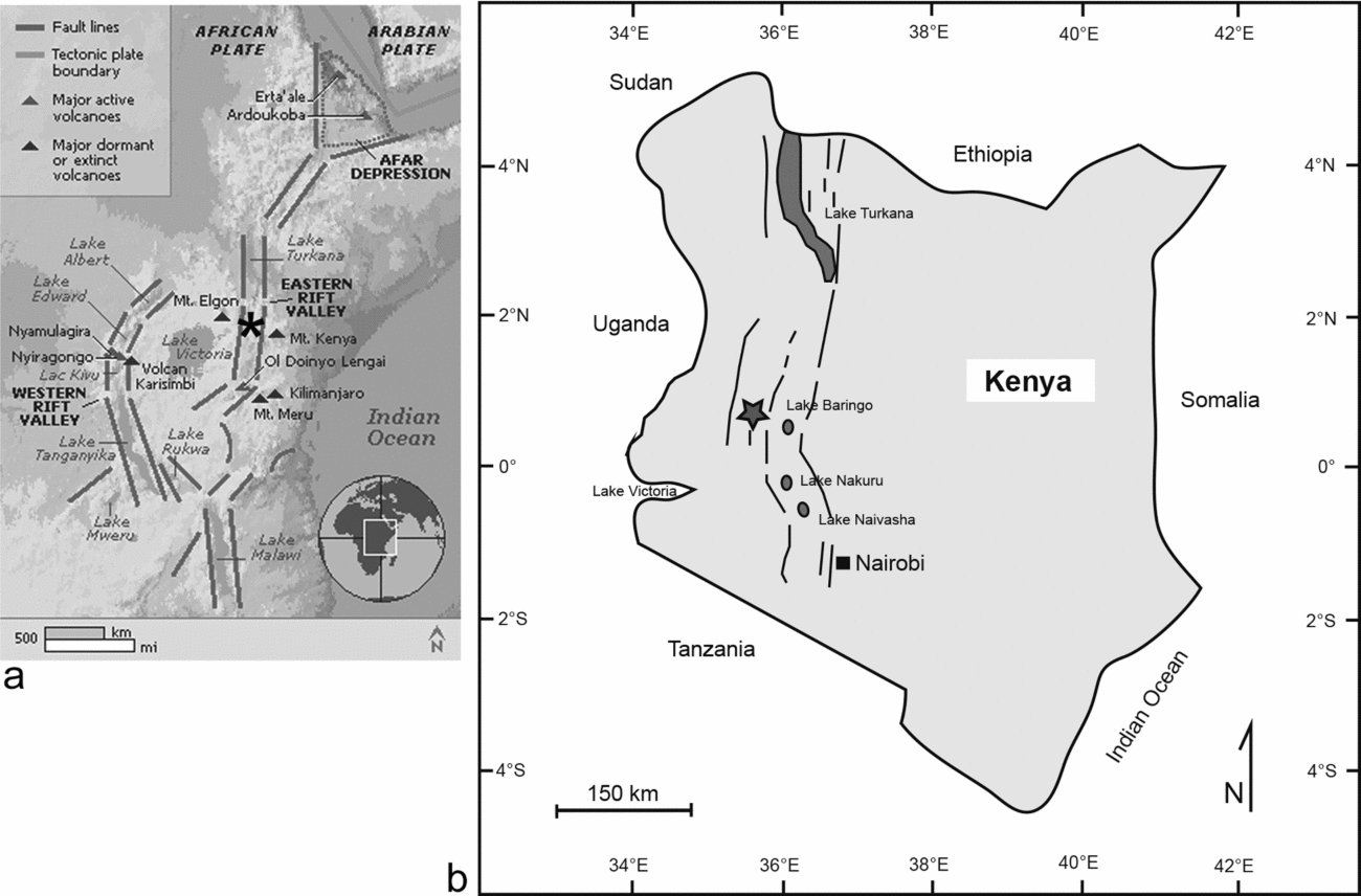
(a) Geographic overview of the East African Rift system, showing the position of the Tugen Hills in the eastern branch of the East African Rift System (indicated with star). Source: http://hudsonvalleygeologist.blogspot.de/. (b) Schematic map of Kenya and neighbouring countries. Black lines indicate the Gregory Rift, which is part of the Eastern branch of the EARS, star marks study area. Source: Anonymous (1987), Schlüter (Reference Schlüter2006).

Fossil fishes also play a critical role in reconstructing ancient ecosystems because the diversity and composition of fish faunas is clearly linked to environmental parameters (e.g. Micklich, Reference Micklich and Poyato-Ariza2005; Reinthal, Cohen & Dettman, Reference Reinthal, Cohen and Dettman2011). However, fish fossils have only been mentioned in passing in several studies on the Tugen Hills (e.g. Bishop & Chapman, Reference Bishop and Chapman1970; Bishop & Pickford, Reference Bishop and Pickford1975; Van Couvering, Reference Van Couvering1977; Pickford, Reference Pickford and Bishop1978). The only detailed studies dedicated to the fossil fish are those by Van Couvering (Reference Van Couvering1982) and Altner & Reichenbacher (Reference Altner and Reichenbacher2015a ). Van Couvering (Reference Van Couvering1982) described the new cichlid species Sarotherodon martyni from the Ngorora Formation. Altner & Reichenbacher (Reference Altner and Reichenbacher2015a ) introduced the new killifish family Kenyaichthyidae, to which they attributed the new genus and species Kenyaichthys kipkechi from the upper Miocene Lukeino Formation. It should be noted that, as a general rule, completely preserved fossil fishes are relatively rare finds. However, in cases where large numbers of specimens occur together, these assemblages can provide valuable hints to unusual environmental events that caused the kills and also promoted fish preservation. In addition, the composition of such samples yields insights into prevailing conditions prior to the die-off.
Judging by the abundance and, in many cases, complete preservation of fish fossils, the Miocene sediments of the Tugen Hills appear to represent a fish Lagerstätte, although this has never been explicitly asserted. Generally, fossil Lagerstätten are characterized by abundant and/or exceptionally preserved fossil specimens, the former being termed Concentration and the latter Conservation Lagerstätten (Seilacher, Reif & Westphal, Reference Seilacher, Reif and Westphal1985; Liu et al. Reference Liu, McKay, Young, Witzke, McVey and Liu2006). Several important fish Lagerstätten from the Cenozoic Era are known, including famous localities such as the Eocene sediments at Messel, Germany (e.g. Micklich, Reference Micklich2012), the Green River Formation, USA (e.g. Grande, Reference Grande1984; Hellawell & Orr, Reference Hellawell and Orr2012) and Monte Bolca, Italy (e.g. Blot, Reference Blot1984; Bellwood & Sorbini, Reference Bellwood and Sorbini1996; Tyler & Sorbini, Reference Tyler and Sorbini1999; Bannikov, Reference Bannikov2004; Carnevale & Pietsch, Reference Carnevale and Pietsch2009, Reference Carnevale and Pietsch2010). Further examples are the Outer Carpathians of Poland (lower Oligocene; Bieńkowska-Wasiluk, Reference Bieńkowska-Wasiluk2010), Aix-en-Provence in southern France (upper Oligocene; Gaudant, Reference Gaudant1978; Gierl et al. Reference Gierl, Reichenbacher, Gaudant, Erpenbeck and Pharisat2013) and St Margarethen in Austria (middle Miocene; Schultz, Reference Schultz1993, Reference Schultz2006b , Reference Schultz a ; Carnevale & Collette, Reference Carnevale and Collette2014). Notably, most of the known Cenozoic fish Lagerstätten are located in Europe, represent local spots of exceptional preservation and are, for the most part, no longer accessible.
The objective of this study is to gain a better understanding of how changing palaeoenvironments in East Africa might have influenced human evolution. To achieve this, we provide a detailed description of the middle–upper Miocene Ngorora Formation from the Tugen Hills, including an overview of the Ngorora fish Lagerstätte. Special emphasis is placed on palynological analyses, as palynomorphs are a good proxy for palaeoclimate reconstructions, but no pollen data from Tugen Hill sediments have been published before. In addition, we describe some isolated new mammal finds.
2. Geological setting
2.a. The Central Kenya Rift
The East African Rift System (EARS) originated during late Oligocene – early Miocene time and represents one of the largest active continental rift structures on Earth (e.g. Chorowicz, Reference Chorowicz2005). The starting point of the EARS is the Afar depression in northern Ethiopia, where the Red Sea, the Gulf of Aden and the EARS meet in a triple junction (Chorowicz, Reference Chorowicz2005). The EARS itself extends about 6000 km to the south and consists of three major branches: the Eastern branch; the Western branch; and the Mozambique Channel (Chorowicz, Reference Chorowicz2005; Roberts et al. Reference Roberts, Stevens, O’Connor, Dirks, Gottfried, Clyde, Armstrong, Kemp and Hemming2012). The Gregory Rift, which stretches over 900 km from the Lake Turkana Basin (4°30′N) to the North Tanzanian Divergence (2°S) (Smith, Reference Smith1994; Hautot et al. Reference Hautot, Tarits, Whaler, Le Gall, Tiercelin and Le Turdu2000), lies within the Eastern branch of the EARS (Fig. 1).
Our study area is located in the Central Kenya Rift, which forms part of the Gregory Rift and extends between the equator and 1°N (Fig. 1) (Tiercelin & Lezzar, Reference Tiercelin, Lezzar, Odada and Olago2002). It is characterized by a double fault in the west represented by the Elgeyo and Saimo/Kito Pass Faults, the intra-rift horsts of the Saimo and Sidekh blocks and the north–south-propagating Baringo and Kerio basins (Hautot et al. Reference Hautot, Tarits, Whaler, Le Gall, Tiercelin and Le Turdu2000; Figs 1, 2a).
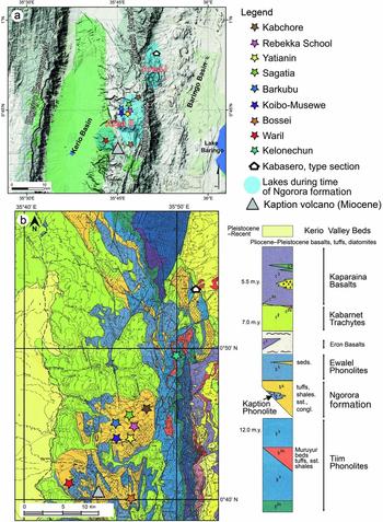
Overview of the (a) topography and (b) geology of the study area in the Tugen Hills (Baringo County, Kenya). The locations of the study sites in the Ngorora Formation and the position of the Kabasero type section are shown. The extents of earlier lakes in areas I (Kabasero sub-basin) and II (Kapkiamu sub-basin) of the Ngorora Basin are depicted after Bishop & Pickford (Reference Bishop and Pickford1975). Sources: (a) Google Maps, (b) Geological Map of the Northern Tugen Hills (Chapman, Lippard & Martyn, Reference Chapman, Lippard and Martyn1973).

2.b. The Tugen Hills
The Tugen Hills (also referred to as the Kamasia Hills in previous work) are situated within the Central Kenya Rift west of Lake Baringo and encompass the Saimo and Sidekh blocks and adjacent mountainous regions (Bishop & Chapman, Reference Bishop and Chapman1970; Hautot et al. Reference Hautot, Tarits, Whaler, Le Gall, Tiercelin and Le Turdu2000; Fig. 2a). They extend about 100 km north–south and reach a maximum altitude of 2400 m on the Saimo Horst. The volcaniclastic and sedimentary successions of the Tugen Hills are up to 3000 m thick and represent one of the most complete Neogene successions in Africa (Hill, Reference Hill2002). The present-day accessibility of these deposits results from the geological history. Located within the Gregory Rift, the area was subject to subsidence and was filled with sediments during Miocene and Pliocene time and has undergone uplifting since late Pliocene time (Chapman, Lippard & Martyn, Reference Chapman, Lippard and Martyn1973; Pickford, Reference Pickford and Bishop1978, Reference Pickford1994; Fig. 2b). Five main lithostratigraphic units have been recognized for the Miocene sediments in the Tugen Hills: (i) the middle Miocene Muruyur Formation; (ii) the middle–upper Miocene Ngorora Formation; (ii) the upper Miocene Ngerngerwa Formation; (iv) the Mpesida Beds and (v) the Lukeino Formation (Bishop & Chapman, Reference Bishop and Chapman1970; Bishop et al. Reference Bishop, Chapman, Hill and Miller1971; Pickford, Reference Pickford1994). Each of these represents a lacustrine or fluvial setting that developed as a result of tectonic subsidence and was eventually obliterated by reactivation of volcanism (see review in Hill, Reference Hill2002).
Several research groups have investigated the rock sequences in the Tugen Hills in detail since the mid-1960s. Basil King and Bill Bishop (both Bedford College, University of London) launched the initial major phases of research and recognized the geological, stratigraphic and palaeontological frameworks (e.g. Bishop et al. Reference Bishop, Chapman, Hill and Miller1971; King & Chapman, Reference King and Chapman1972; Chapman & Brook, Reference Chapman, Brook and Bishop1978). Later, the Baringo Paleontological Research Project (BPRP), a collaborative project between the National Museums of Kenya and the Yale and Harvard universities (USA), and also the French research group of the Kenya Palaeontology Expedition (based in Paris, France) focused on the faunal evolution in the context of local and regional environments and global climate, with emphasis on radiometric dating and fossil mammals, particularly hominoids (e.g. Pickford, Reference Pickford1988; Senut et al. Reference Senut, Pickford, Gommery, Mein, Cheboi and Coppens2001; Behrensmeyer et al. Reference Behrensmeyer, Deino, Hill, Kingston and Saunders2002; Hill, Reference Hill2002). In addition, some reviews have been published on the Neogene history of vegetation, climate change and hominid evolution in Africa (e.g. Trauth et al. Reference Trauth, Maslin, Deino and Strecker2005, Reference Trauth, Maslin, Deino, Strecker, Bergner and Dühnforth2007; Senut, Pickford & Ségalen, Reference Senut, Pickford and Ségalen2009; Bonnefille, Reference Bonnefille2010; Jacobs, Pan & Scotese, Reference Jacobs, Pan, Scotese, Werdelin and Sanders2010). All these studies have referred to data from the Tugen Hill successions (among others).
2.c. The Ngorora Basin
The Ngorora Formation to which this study is dedicated accumulated in the Ngorora Basin. This basin is bounded to the north by the upland around the Tiati Volcano and to the west by the Elgeyo escarpment (Bishop & Pickford, Reference Bishop and Pickford1975). The topographic highs to the east of the Ngorora Basin are the Saimo and Sidekh horsts (Fig. 2a). The lowland between these two horsts covered an area of about 8 km2, extending the Ngorora Basin further to the east (Bishop & Pickford, Reference Bishop and Pickford1975). To the southwest of the Ngorora Basin the highland of the Kaption Volcano formed the basin's boundary, while its southern limit is not known (Bishop & Pickford, Reference Bishop and Pickford1975).
Differences in lithofacies have led to the identification of three separate sub-basins (‘Areas’) within the Ngorora Basin (Bishop & Pickford, Reference Bishop and Pickford1975) (Fig. 2a). Area I is located north of the Saimo Horst and includes the type section of the Ngorora Formation (Kabasero section); Area II is situated west of the Saimo Horst, and has been referred to as the Kapkiamu Graben, Kapkiamu Basin or Kapkiamu Sub-basin in previous work (Pickford, Reference Pickford and Bishop1978; Renaut et al. Reference Renaut, Ego, Tiercelin, Le Turdu, Owen, Andrews and Banham1999); and Area III lies to the south of the Saimo Horst. These three sub-basins of the Ngorora Basin were at least partially isolated from each other; no marker horizons have been found and correlation between them remains tentative (Bishop & Pickford, Reference Bishop and Pickford1975; Renaut et al. Reference Renaut, Ego, Tiercelin, Le Turdu, Owen, Andrews and Banham1999).
2.d. The Ngorora Formation
The Ngorora Formation consists of alternations of volcaniclastic or tuffaceous beds with fluvial or lacustrine siliciclastic deposits; palaeosols can be intercalated (Bishop & Chapman, Reference Bishop and Chapman1970; Bishop & Pickford, Reference Bishop and Pickford1975). Numerous fossils, mainly terrestrial forms (e.g. mammals, turtles, insects) but also some aquatic elements (e.g. fishes, crocodiles, ostracods) have been found in the Ngorora Formation and a maximal thickness of about 365 m has been recorded for its type area at Kabarsero (0°54′N, 35°51′W) (Bishop & Chapman, Reference Bishop and Chapman1970; Bishop & Pickford, Reference Bishop and Pickford1975; Pickford, Reference Pickford and Bishop1978; Van Couvering, Reference Van Couvering1982; Pickford, Reference Pickford2001b ). The particularly rich macrobotanical record known from the Kabarsero type section comprises an autochthonous assemblage of leaves, twigs and fruits preserved in a tuff that has been dated to 12.6 Ma (Jacobs & Kabuye, Reference Jacobs and Kabuye1987, Reference Jacobs and Kabuye1989; Jacobs & Winkler, Reference Jacobs and Winkler1992; Jacobs & Deino, Reference Jacobs and Deino1996). Further plant remains from the Ngorora Formation have only been reported from the site Waril, dated at c. 10 Ma based on lithostratigraphy (Jacobs, Reference Jacobs1999, Reference Jacobs2002).
The underlying rocks of the Ngorora Formation are those of the Tiim Phonolites and the overlying unit is represented by the Ewalel Phonolites (Bishop & Pickford, Reference Bishop and Pickford1975; Fig. 2b). The age of the Ngorora Formation ranges from c. 13.1 Ma to c. 7.8 Ma according to Deino et al. (Reference Deino, Tauxe, Monaghan and Drake1990). These authors provided data from sections in the Kabarsero type area based on (i) single-crystal 40Ar/39Ar dates from the uppermost flows of the Tiim Phonolites, indicative of an end of the phonolitic activity by 13.2 Ma; (ii) single-crystal 40Ar/39Ar ages from tuff- and lapilli-bearing sediments, indicating an age range of 13.06–10.51 Ma from the base towards the top of the Ngorora Formation, and (iii) K–Ar age dates from the Ewalel Phonolites that overlie the Ngorora Formation (7.60±0.14 Ma and 7.26±0.17 Ma) (Deino et al. Reference Deino, Tauxe, Monaghan and Drake1990). Previous K–Ar age dates from the Ewalel Phonolites have indicated an age range of 9.0–6.9 Ma for this unit (Chapman & Brook, Reference Chapman, Brook and Bishop1978), but Deino et al. (Reference Deino, Tauxe, Monaghan and Drake1990) consider their new ages as more reliable because their samples have a higher 40Ar content.
Deino et al. (Reference Deino, Tauxe, Monaghan and Drake1990) used the Fish Canyon sanidine (FCs) as an age reference, with an 40Ar/39Ar age of 27.84 Ma given by Cebula et al. (Reference Cebula, Kunk, Mehnert, Naeser, Obradovich and Sutter1986). In the meantime, however, several studies have suggested revisions of the FCs age, based on the use of various astronomical approaches or on optimization-based calibration of the 40Ar/39Ar system (see Lenz et al. Reference Lenz, Wilde, Mertz and Riegel2015). Renne et al. (Reference Renne, Balco, Ludwig, Mundil, Min and Renne2011) proposed an ‘actual’ FCs age of 28.294±0.036 Ma (1σ) based on a statistical optimization approach by calibrating the 40Ar /39Ar system to the 238U–206Pb system. This age overlaps within 2σ with the astronomically derived result of 28.201 reported by Kuiper et al. (Reference Kuiper, Deino, Hilgen, Krijgsman, Renne and Wijbrans2008). Recalculation of the 40Ar /39Ar from the uppermost flows of the Tiim Phonolites based on these revised dates and using the ArArReCalc_7–31–09.xls Excel sheet provided by Noah McLean (www.earth-time.org) implies that the phonolitic activity ended c. 200 ka earlier than previously assumed. We therefore introduce a revised age of c. 13.3 Ma for the onset of the Ngorora Formation.
Moreover, the Ngorora Formation can be subdivided into five lithostratigraphic units (A to E, from bottom to top) that were initially described based on the Kabasero type section (Bishop & Chapman, Reference Bishop and Chapman1970) and were later defined as lithostratigraphic members (Bishop & Pickford, Reference Bishop and Pickford1975). Each member comprises a characteristic lithofacies of volcaniclastic, fluviatile or lacustrine sediments. The deposits of Member A (92 m thickness), Member B (42 m thickness) and Member E (105 m thickness) are exclusively present in Area I, while the successions of Member C (66 m thickness) and Member D (105 m thickness) have also been reported for Area II (Bishop & Chapman, Reference Bishop and Chapman1970; Pickford, Reference Pickford and Bishop1978).
Bishop & Pickford (Reference Bishop and Pickford1975) and Pickford (Reference Pickford and Bishop1978) suggested that three lakes developed during the time represented by Member C, that is, the Kabarsero Lake (Area I), the Kapkiamu Lake (Area II) and the Waril Lake (west of Kaption; still Area II) (Fig. 2a). Based on mineralogical investigations and the presence or absence of freshwater fossils, freshwater environments have been assumed for the Kabarsero and Waril lakes while an alkaline setting was postulated for the Kapkiamu Lake (Bishop & Pickford, Reference Bishop and Pickford1975; Van Couvering, Reference Van Couvering1982; Renaut et al. Reference Renaut, Ego, Tiercelin, Le Turdu, Owen, Andrews and Banham1999; Tiercelin & Lezzar, Reference Tiercelin, Lezzar, Odada and Olago2002).
3. Study area and sections
The study area is located in the Tugen Hills, west of the towns of Kamelon and Kipsaraman. It extends as far as Kapkiamu to the south and the settlement Barwessa to the southwest, and lies largely within Area II (Kapkiamu Sub-basin) of the Ngorora Basin (Fig. 2a). The ancient Kaption Volcano divides the study area into a southwestern segment corresponding to the ‘region west of Kaption’ (sensu Bishop & Pickford, Reference Bishop and Pickford1975) and a southeastern segment near Kapkiamu, which has experienced major faulting (Fig. 2b).
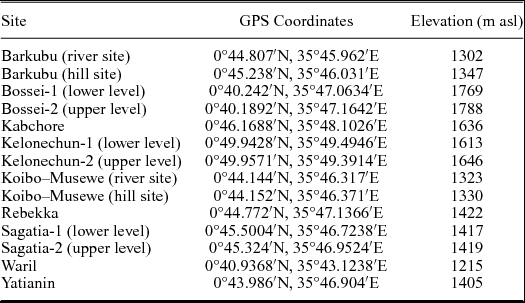
Nine sections were studied based on natural outcrops along rivers or in the hills. Their altitudes above sea level (asl) were obtained from Google Earth as GPS-based altitudes were not always precise. Each section was designated by the name of the respective area provided by local residents (Table 1). Kelonechun is the only site located in Area I; all other sites belong to Area II (Fig. 2a).
Coordinates (GPS data taken in the field) and altitude data (based on Google Earth) of all studied sections (in alphabetical order).

4. Methods
4.a. Logging of sections
Standard mapping techniques were used to log the profiles and study their sedimentological characteristics. Individual layers were documented at a scale of centimetres to decimetres.
4.b. Pollen preparation and analysis
Six sections (Bossei, Kabchore, Kelonechun, Rebekka School, Sagatia and Waril) were sampled for palynological data, and a total of 37 samples from these sites were processed for palynological analysis. At least one sample was taken from each layer of the six sections. All samples were treated with HCl, HF and KOH following the standard procedures described in Kaiser & Ashraf (Reference Kaiser and Ashraf1974). In addition, the residue was sieved with a mesh of size 10 μm. Some of the residues were slightly oxidized by applying H2O2 in order to remove flocculating organic matter and improve the transparency of individual palynomorphs. In 12 of the 37 samples, pollen and spores of vascular plants as well as NPPs (non-pollen palynomorphs, e.g. fungal spores, testate amoebae) of good quality were found, albeit usually in small numbers. Furthermore, besides several opaque and translucent phytoclasts in two of the samples, epidermal cells of bryophtyes and tracheid fragments of coniferous wood were recognized. However, in most of the 12 samples the numbers of pollen and spores are too low to yield meaningful counts that would permit the qualitative and quantitative composition of the Miocene vegetation to be determined. Nevertheless, it is possible to provide general palaeoenvironmental interpretations.
4.c. Clay mineral analysis
Three sections (Bossei, Sagatia and Waril) were sampled for clay mineral analysis, and a total of six samples from these sites were processed for bulk-rock and clay mineralogy. Sample preparation followed the procedures described by Moore & Reynolds (Reference Moore and Reynolds1997). XRD analyses were performed on unoriented powder specimens for bulk-rock samples and on oriented powder samples for the clay-sized fractions. The entire rock and clay mineral composition was scanned with a PANalytical X’pert PRO diffractometer (Cu-Kα radiation generated at 40 kV and 30 mA) equipped with a variable divergence slit and an X’Celerator detector (Goethe University, Frankfurt am Main). The whole-rock powder specimens were scanned at 2.5–90° 2θ with a counting time of 5 s per step. The oriented specimens were scanned at 2–40° 2θ (air-dried specimens) or 2–22° 2θ (ethylene glycol solvated specimens) with a step size of 0.0084° 2θ and a counting time of 10 s per step. The semi-quantitative measurements of the whole-rock samples were corrected by the Reference Intensity Ratio (RIR). This ratio normalizes all diffraction data to a (corundum) standard (International Center for Diffraction Data (ICCD), PDF-2). The XRD diagrams were analysed using the program MacDiff (R. Petschick, http://www.geol-pal.uni-frankfurt.de/Staff/Homepages/Petschick/classicsoftware.html, 2001). The terms smectite, illite and kaolinite are used in a general sense to refer to the individual mineral groups. Ratios of integrated peak regions of their basal reflections (Petschick, Kuhn & Gingele, Reference Petschick, Kuhn and Gingele1996), weighted by empirically estimated factors (Biscaye, Reference Biscaye1965) were used to determine the relative clay mineral content (rel%).
4.d. Fossil collection, preparation and analysis
Articulated fish fossils were collected in the field by carefully splitting the sediments along bedding planes using hammers and chisels. Due to their fragility, fish fossils were consolidated immediately after collection using a mixture of Mowilith (a polyvinyl acetate) and acetone. Mammalian fossils were recovered by screening the sediment surface and, in the case of the suid (see Sections 5.c. and 8 below), based on hints from local residents. After transport of all fossils to Munich, remnants of sediment were removed from the specimens under a stereomicroscope, either by hand with a needle or with a scribing or engraving pen.
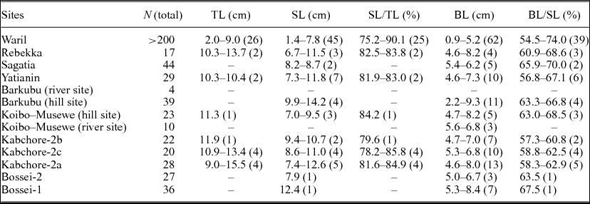
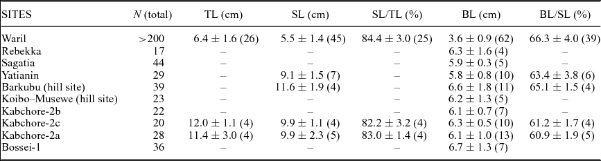
For the fish fossils, standard measurements were made (to the nearest 0.5 mm) with a digital vernier calliper comprising total length (TL, from the tip of the premaxilla to the end of the caudal fin), standard length (SL, from the tip of the premaxilla to the end of the hypural plate) and body length (BL, from the dorsocaudal margin of the opercle to the end of the hypural plate). Meristic characters included counts of dorsal, anal, pectoral and pelvic fin rays, principal caudal fin rays, abdominal vertebrae and caudal vertebrae. Some teeth were isolated from selected specimens for analysis of tooth shape and size. Osteological studies focused on the caudal endoskeleton, which provides important information at higher systematic levels. Detailed taxonomic descriptions of the fish fossils are currently in preparation (Altner, Schliewen & Reichenbacher, Reference Altner, Schliewen and Reichenbacher2014; Penk et al. Reference Penk, Rasmussen, Schliewen and Reichenbacher2014; Altner & Reichenbacher, Reference Altner and Reichenbacher2015b ; Penk & Reichenbacher, Reference Penk and Reichenbacher2015).
5. Description and interpretation of the studied sections
In the following we present the sedimentary sequences and fossils for the nine studied sections, together with palynological findings (from six sections) and XRD data (from three sections), and we use these data to provide a palaeoenvironmental interpretation for each section. The sections are described from the stratigraphically oldest to the youngest (see Section 6 below). Figure 2 illustrates the geographic and geological setting for all sections.
5.a. Kelonechun section
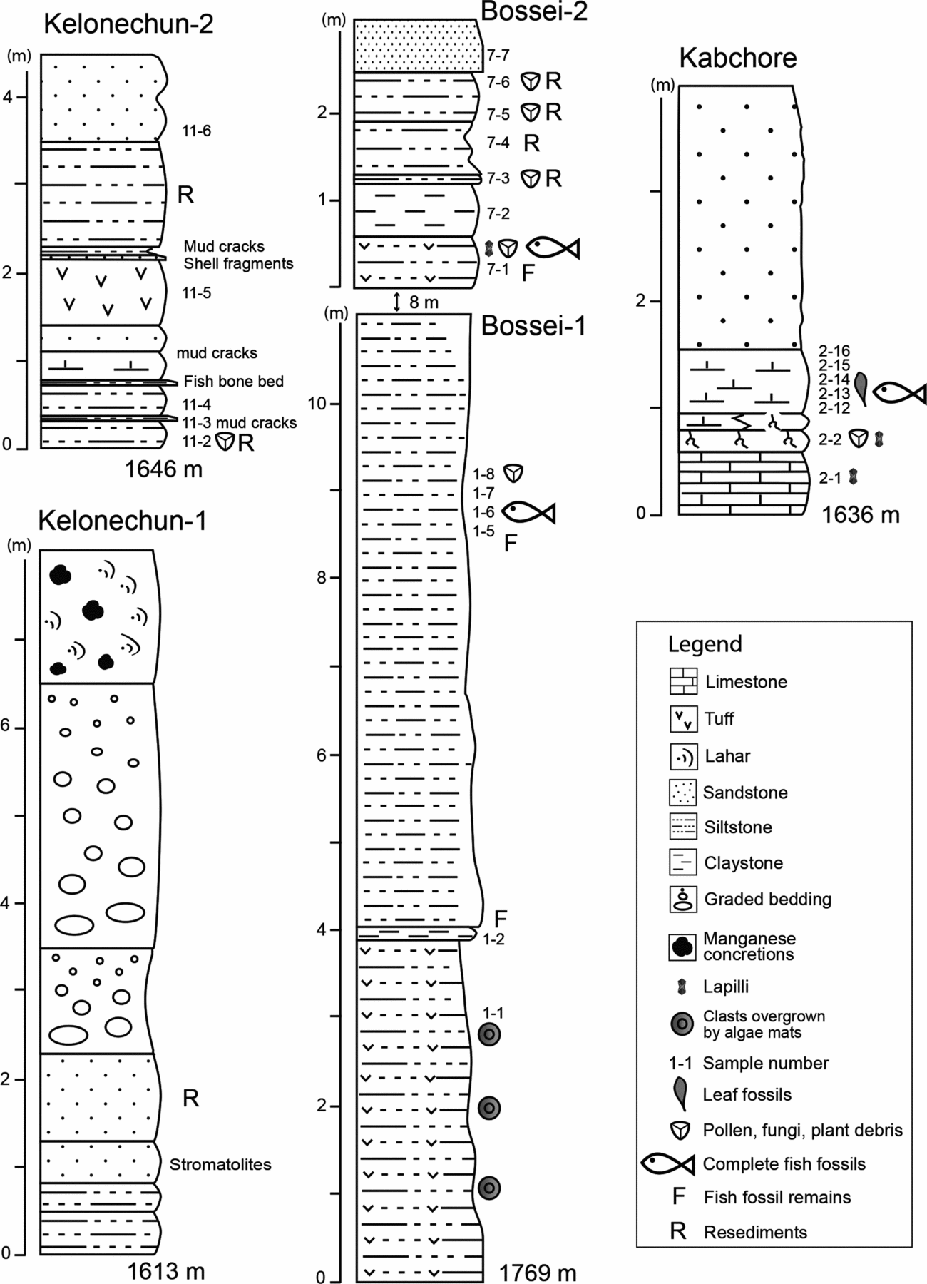
The Kelonechun section is located in Area I, near the Kabasero type section (Fig. 2). The section consists of two outcrops with a gap of c. 25 m between them (Fig. 3). Kelonechun-1, the lower of the two (1613 m asl), is exposed on a hill slope and its layers dip 30° to the west. Kelonechun-2, the upper outcrop (1646 m asl), is located near a small road.
Overview of the Kelonechun (Area I), Bossei and Kabchore (Area II) sections showing lithofacies and fossils. Altitudes are given in metres above sea level.

5.a.1. Sedimentary sequence and occurrence of fossils
The succession exposed at Kelonechun-1 is c. 8.0 m thick. Its lowest layers consist (from bottom to top) of red claystone (0.5 m), beige siltstone (0.3 m) and sandstone-bearing (0.3–0.5 m) silicified stromatolites (5–10 cm diameter). These are followed by red silt- to fine sandstone (1.0 m) and two distinct siltstone layers (1.2 m and 3.0 m), each of which displays graded bedding section-upwards, beginning with pebbles at the bottom. The top of the section consists of a beige-coloured sandstone (1.0 m) with thick manganese concretions, which is overlain by a thick succession of lahar.
Kelonechun-2 has a thickness of c. 4.5 m. The lowermost layer comprises 0.3 m green siltstone (no. 11–2, 11–3) with fissures (mud-cracks) up to 6 cm deep. Another green siltstone (0.34 m; no. 11–4) follows and is overlain by a bone bed (0.06 m) containing numerous fish remains. The bone bed is overlain by 0.3 m of brown marl with a mud-cracked surface, 0.3 m of medium- to coarse-grained sandstone, 0.75 m of silty tuff (no. 11–5) and a thin layer (0.05–0.1 m) of poorly sorted, medium- to coarse-grained sandstone with shell fragments, pebbles and prominent, up to 0.13-m-deep mud cracks. This is followed by 1.4 m homogenous siltstones with some reworked claystone pebbles. The topmost layer consists of 1 m of red to beige, homogenous silt- to fine sandstone (no. 11–6).
5.a.2. Palynology
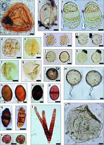
Five samples from Kelonechun-2 were processed for palynological analysis (nos. 11–2 to 11–6). Only sample 11–2 is characterized by palynomorphs, which comprise a relatively high number of taxa. The flora is mainly composed of grasses (Poaceae), Acacia (Mimosidae, Fabaceae/Leguminosae) and Podocarpus (Podocarpaceae, Fig. 4c). In addition, monolete fern spores (Polypodiaceae, Fig. 4b) and frequent occurrences of pollen of Acalypha (Euphorbiaceae, Fig. 4i) are characteristic elements of the pollen spectrum as well as some unknown tricolporate taxa, which are probably pollen of Burseraceae (Fig. 4j) and Anarcardiaceae (Fig. 4k). Some monoporate one-celled fungal spores, possibly representing mycorrhizal fungi such as Glomus (Fig. 4l), also occur in sample no. 11–2.
Pollen, spores and non-pollen palynomorphs found in the Kelonechun 2, Bossei-1, -2 and Kabchore sections: (a) fern spore, Pteris type (Pteridaceae), Bossei-2, no. 7–7; (b) fern spore, Polypodiaceae, Kelonechun 2, no. 11–2; (c) pollen of Podocarpus, Kelonechun 2, no. 11–2; (d) pollen of Acacia (Mimosaceae, thorntree), Bossei-1, no. 1–7/6; (e) Juniperus type pollen (Cupressaceae), Bossei-1, no. 1–7/6; (f, g) Poaceae pollen, Bossei-1, no. 1–7/6; (h) pollen of Asteraceae, Crassocephalum type, Bossei-1, no. 1–7/6; (i) pollen of Acalypha (Euphorbiaceae), Kelonechun 2, no. 11–2; (j) pollen, tricolporate, cf. Burseraceae, Kelonechun 2, no. 11–2; (k) pollen, tricolporate, cf. Anarcardiaceae (Rhus type), Kelonechun 2, no. 11–2; (l–s) fungal spores: (l) unknown one-celled monoporate fungal spore, cf. Glomus, Kelonechun 2, no. 11–2; (m) Glomus sp., Kabchore, no. 2–2; (n, o) type 1093 sensu Gelorini et al. Reference Gelorini, Verbeken, van Geel, Cocquyt and Verschuren2011, cf. Gelasinospora, Kabchore, no. 2–2; (p) Delitschia-type, Bossei-1, no. 1–7/6; (q) type 1082 sensu Gelorini et al. Reference Gelorini, Verbeken, van Geel, Cocquyt and Verschuren2011, Kabchore, no. 2–2; (r) Hysterium-type, Kabchore, no. 2–2; (s) Spegazzinia-type, Bossei-2, no. 7–1; (t) fungal hyphae, Bossei-1, no. 1–7/6; (u) testate amoeba; Arcella cf. hemisphaerica, Bossei-2, no. 7–7. Scale bars: (a–s) 10 μm, (t, u) 20 μm.

5.a.3. Interpretation
Kelonechun-1 reveals a partly lacustrine (presence of clay- and siltstones and stromatolites) and partly high-energy environment (gradation of siltstones) that was finally buried by lahar deposits. The lithofacies of Kelonechun-2, in particular the presence of very prominent mud cracks, may indicate that the area was tectonically active and experienced several episodes of uplift, leading to desiccation of formerly lacustrine or fluviatile settings.
Desiccation is generally extremely unfavourable for the preservation of palynomorphs and explains why the organic matter that may have been deposited in the Kelonechun-2 record is in most samples completely oxidized and degraded. Only sample no. 11–2 contains palynomorphs in large numbers. In this sample, the co-occurrence of grass pollen (Poaceae) with pollen of Acacia (thorntree) point to a fossil assemblage of grasses and woody tropical dicots, which is similar to that in the lower outcrop of the Bossei section. In addition, Acalypha pollen (Euphorbiaceae) indicates that these plants were also part of the vegetation within a woodland to wooded grassland environment. The monolete and trilete fern spores attest to the ground cover in moist patches in this environment, while the rare bisaccate pollen of Podocarpus may indicate that dry Afromontane forests were distributed in the wider vicinity of the Kelonechun site (Retallack, Reference Retallack1992).
5.b. Bossei section
The Bossei section is located near Kapkiamu in the southern part of Area II (Fig. 2). It consists of two outcrops with a gap of 8 m between them (Fig. 3). Bossei-1 is the lower outcrop (1769 m asl) and is exposed along a hill slope while Bossei-2, located on the side of a small road, maps above it (1788 m asl). Bedding planes in all layers are horizontal.
5.b.1. Sedimentary sequence and occurrence of fossils
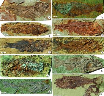
The 11-m-thick Bossei-1 section begins with c. 4 m of brownish-to-grey tuff (no. 1–1) containing rounded clasts (5–15 cm) with layered ‘crusts’ (?microbial mats). The tuff is overlain by 0.1 m of dark-brown–green, laminated claystone (no. 1–2). Section-upwards follows a homogenous succession of at least 7 m laminated silicified siltstones (no. 1–5). The uppermost 100 cm of this succession (no. 1–6 to 1–8) yielded articulated, but mostly incomplete, fish fossils (Fig. 5a).
Articulated fish fossils from the Ngorora fish Lagerstätte in the Tugen Hills. (a) OCO-702b, Bossei-1; (b) OCO-2c-4a, Kabchore; (c) OCO-12–8, Koibo–Musewe (hill site); (d) OCO-9a-14, Barkubu (hill site); (e, f) OCO-11–19b, OCO-11–3b, Yatianin; (g) OCO-6–3, Sagatia; (h, i) OCO-3–3b, OCO-3–6b, Rebekka; and (j) OCO-5–37, Waril.

Bossei-2 (c. 2.7 m) continues the succession of laminated silicified siltstones, but also includes some tuff. The lowermost, highly compacted and finely laminated, beige–white siltstone (no. 7–1) is 0.6 m thick and bears several articulated but mostly incomplete fish fossils. The siltstone is overlain by a 0.6-m-thick green, laminated and lapilli-bearing claystone (no. 7–2). Above this is a thin (0.06–0.1 m), highly compacted layer of green siltstone (no. 7–3) with some quartz stringers and reworked claystone fragments. This is followed by a claystone–siltstone alternation with slight tendency to coarsening upwards (1.2 m, nos 7–4 to 7–7). A fine-grained sandstone (0.5 m) terminates the exposure.
5.b.2. XRD analysis
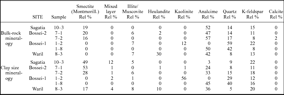
Two samples from Bossei-1 (nos 1–2, 1–8) and two samples from Bossei-2 (nos 7–1, 7–2) were analysed for bulk-rock and clay mineralogy.
The two samples from Bossei-1 reveal a clear difference in their mineralogical composition. Sample 1–2, from the clay layer directly above the tuff, shows a variable composition. The relative quartz content is 59%, k-feldspar constitutes 22%, a relatively high level of kaolinite is present (12%) and illite/muscovite accounts for 7% of the sample. In contrast, sample 1–8 from the fish-bearing layer largely comprises analcime (50%) and quartz (41%) and a lesser amount of k-feldspar (8%). The differences between the two samples are even more prominent in the clay fraction; sample 1–2 shows a very high kaolinite content (56%), while quartz (29%) and k-feldspar (12%) constitute most of the rest of this assemblage. Mixed-layer minerals (2%) and illite (1%) occur only in quantities near their detection limits. In contrast, sample 1–8 does not contain any kaolinite at all, and its clay fraction is made up of analcime (45%), quartz (40%) and k-feldspar (16%).
The samples from Bossei-2 exhibit a more uniform mineralogy. Sample 7–1 again shows high levels of analcime (48%), quartz (14%) and k-feldspar (11%), but a significant amount of montmorillonitic smectite is present (20%); illite/muscovite and heulandite (with 6% and 2%, respectively) are much less prominent. Sample 7–2 shows a similar composition. Analcime (57%), quartz (17%) and k-feldspar (8%) again account for the majority of minerals, while the rest consists of montmorillionite (15%) and – for the first time – calcite (2%). The clay mineral analysis shows that sample 7–1 is dominated by smectite clay minerals (53%). Mixed-layer minerals (2%), kaolinite (1%) and heulandite (1%) make up only a very small percentage of the overall composition, while analcime (24%), quartz (9%) and k-feldspar (11%) account for a larger proportion of this sample. The clay mineral fraction of sample 7–2 shows considerably lower amounts of smectite (28%) than sample 7–1, while analcime (32%), quartz (15%) and k-feldspar (18%) are more prominent. Further constituents of sample 7–2 are illite (6%) and mixed-layer minerals (1%).
5.b.3. Palynology
Four samples from Bossei-1 (nos 1–1, 1–5, 1–7/6 and 1–8) and seven samples from Bossei-2 (nos 7–1 to 7–7) were subjected to palynological analysis.
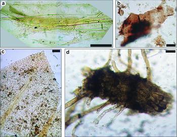
In Bossei-1, samples 1–5 and 1–7/6 contain palynomorphs whereas the other samples are almost devoid of organic material. A single grain of grass pollen was found in sample 1–8. Poorly preserved unicellular fungal spores, which could not be assigned to a genus or a morphotype, characterize sample 1–5. In contrast, sample 1–7/6 reveals a diverse palynoflora. Fungal spores, which are morphologically most similar to saprotrophs such as Delitschia (Fig. 4p), are frequent. Hyphae (Fig. 4t) and fruiting bodies of fungi can be assigned to a number of extant taxa (see Jansonius & Kalgutkar, Reference Jansonius and Kalgutkar2000). The pollen record is dominated by grass pollen (Poaceae, Fig. 4f, g), which occurs together with pollen of Acacia (subfamily Mimosoideae, family Fabaceae resp. Leguminosae, Fig. 4d), Asteraceae (Fig. 4h), Juniperus (Cupressaceae, Fig. 4e) and Podocarpus (Podocarpaceae). The sample also includes fragments of the tracheid system of conifer wood with characteristic torus-margo pits (Fig. 6a). These are probably fragments of the xylem of Podocarpus. The fragments are large, very well preserved and not macerated.
Plant remains found in the samples from the Bossei and Kabchore sections: (a) tracheid fragment from conifer wood (Podocarpus?) with torus-margo pits, Bossei-1, no. 1–7/6; (b) brown, translucent, decomposed phytoclasts, Bossei-2, no. 7–3; (c) epidermis of a grass (?) root with characteristic root hairs, Kabchore, no. 2–2; and (d) epidermal cells, probably belonging to bryophyte, Kabchore, no. 2–2. Scale bars: 20 μm.

In Bossei-2, sample 7–1 contains small numbers of palynomorphs, especially pollen of Hydrocharitaceae or Alismataceae. The fungal spores show similarities to the spore type 1018B of Gelorini et al. (Reference Gelorini, Verbeken, van Geel, Cocquyt and Verschuren2011), a fungal morphotype that can be assigned to Spegazzinia (Fig. 4s). While samples 7–2 and 7–4 lack organic material, samples 7–3 and 7–5 are free of palynomorphs but characterized by several phytoclasts; brown, translucent forms (Fig. 6b) are more prominent than the opaque sorts. In samples 7–6 and 7–7, the portion of organic matter decreases and the phytoclasts are significantly smaller. However, sample 7–7 contains various fungal spores (Gelasinospora-type, spore type 1141 of Gelorini et al. Reference Gelorini, Verbeken, van Geel, Cocquyt and Verschuren2011) and a number of well-preserved fern spores which belong to Pteris (Pteridaceae, Fig. 4a). Moreover, this sample is remarkable for the occurrence of testate amoebae of the genus Arcella (Fig. 4u). The shell shows similarities with A. discoides, a species that favours standing-water habitats such as ponds (Payne et al. Reference Payne, Lamentowicz, van der Knaap, van Leeuwen, Mitchell and Mazei2012).
5.b.4. Interpretation
The Bossei-1 succession records the development of a lake after a period of explosive volcanism. Abundance of kaolinite and quartz in the clay mineral fraction of layer 1–2 directly above the tuffs may signal initial soil formation, while there is no evidence for extensive weathering (lack of smectite) or alkaline conditions (lack of analcime). The succeeding 7-m-thick lacustrine succession was deposited in a comparatively deep lake, mostly with anoxic bottom-water conditions (preservation of articulated fish fossils). The water was alkaline, as indicated by high levels of analcime (50%) in the fish-bearing level (no. 1–8). Analcime is an authigenic zeolite, commonly formed from volcanic glass in solution under conditions of increasing salinity and alkalinity (Hay, Reference Hay1968; Surdam & Sheppard, Reference Surdam, Sheppard, Sand and Mumpton1978).
The co-occurrence of grass pollen (Poaceae) with pollen of Acacia in the samples from the lake sediments points to an assemblage of grasses and woody tropical dicots, which are found today in wetter lowland to submontane forest habitats (Retallack, Reference Retallack1992). The Asteraceae, which are now common in lowland and montane grasslands and woodlands, may also have been part of an Acacia-dominated woodland (Retallack, Reference Retallack1992). Pollen of Podocarpus and Juniperus, conifers found in tropical Africa primarily in Afromontane forests (Retallack, Reference Retallack1992), also forms part of the palynomorph spectrum. Although the bisaccate pollen of Podocarpus is specialized for transport over long distances by wind, the well-preserved fragments of the tracheid system of Podocarpus in sample no. 1–6/7 indicate that Podocarpus habitats must have been available very close to the lakeshore at Bossei. The two-celled fungal spores in sample no. 1–6/7 are also noteworthy in this context. They are morphologically most similar to extant saprotrophs such as Delitschia, which are common on soil, dung and other organic substrates (Carmichael et al. Reference Carmichael, Kendrick, Conners and Sigler1980; Barnett & Hunter, Reference Barnett and Hunter1998). Delitschia-type spores are normally constricted at the septum, but very similar two-celled spores are known from modern East African lakes (Gelorini et al. Reference Gelorini, Verbeken, van Geel, Cocquyt and Verschuren2011). The genus Delitschia is indicative of the local presence of significant amounts of dung, which is compatible with the former presence of large herbivores (Gelorini, Ssemmanda & Verschuren, Reference Gelorini, Ssemmanda and Verschuren2012).
The lacustrine period continues in the lower segment of Bossei-2, but the occurrence of lapilli in the fish-bearing siltstone (no. 7–1) indicates a new period of explosive volcanism. The large proportion of analcime (nos 7–1 and 7–2) suggests that the water body remained alkaline, and the relatively high percentages of smectite point to subtropical weathering. Bed no. 7–1 is additionally characterized by pollen of submerged aquatic plants such as Hydrocharitaceae (tape-grass) or Alismataceae, which live in nearshore, shallow waters of freshwater or slightly alkaline lakes (Kennedy et al. Reference Kennedy, Lang, Grimaldo, Martins, Bruce, Hastie, Lowe, Ali, Sichingabula, Dallas, Briggs and Murphy2015). Since the upper level of the Bossei site reflects the demise of a lake widespread shallow zones at the lakeshore can be expected, providing optimal conditions for these plants. The fungi (Spegazzinia) recognized in the same sample (7–1) are widespread in tropical and subtropical regions, and are commonly found on dead leaves and stems of various monocotyledonous plants such as grasses (Ellis, Reference Ellis1971). The fungal spores may therefore point to grassland vegetation in the vicinity of the lake.
In the upper part of Bossei-2, the lacustrine environment changes into a fluviatile setting. The increasing fluvial influence with higher-energy flow is indicated by the increased reworking of phytoclasts (sample 7–7), which are significantly smaller in size than in the samples from the lacustrine segments of the section. Sample 7–7 is also characterized by fern spores (Pteris) and Gelasinospora-type fungal spores. Gelasinospora is mainly known from dung and dead wood (Hanlin, Reference Hanlin1990). The occurrence of testate amoebae of the genus Arcella is particularly striking. Extant species of the genus Arcella live in lakes with different trophic conditions and are especially common in oligotrophic lakes, but ecological differences exist among the different Arcella species (Bovee, Reference Bovee1965; Beyens et al. Reference Beyens, Chardez, De Landtsheer and De Baere1986; Ellison, Reference Ellison1995). They have been reported from modern lakes in Congo (Štěpánek, Reference Štěpánek1963; Chardez, Reference Chardez and Symoens1964), but pre-Quaternary testate amoebae from East Africa have not been described previously. The specimens documented here show great similarity to the extant species A. discoides, which is one of the most hydrophilic terrestrial species among contemporary testate amoebae (Smith, Bobrov & Lara, Reference Smith, Bobrov and Lara2008) and is found in association with the roots of aquatic plants in both rivers and lakes (Lahr & Lopes, Reference Lahr and Lopes2009). An aquatic environment harbouring submerged plants is therefore a prerequisite for the occurrence of these testate amoebae. Unfortunately, there is no direct evidence for aquatic plants in sample 7–7 (unlike sample 7–1, for example). Nevertheless, the presence of riparian plants on the river bank can be assumed, while adjacent floodplains were colonized by ferns during wet phases. The terrestrial fungal spores probably originated in the floodplain environment and were transported into the depositional area during flooding events.
5.c. Kabchore section
The Kabchore section comprises three sites (Kabchore 2a, 2b, 2c) in close vicinity to each other. A small profile is exposed solely in Kabchore 2a (1636 m asl), on the slope of a small riverbed, where a horizontally bedded c. 4-m-thick succession is present (Fig. 3). Approximately 15 m above Kabchore 2a, isolated large blocks of beige, strongly compacted, well-bedded siltstones (up to 2 m thickness) were found in an abandoned quarry, which yielded exclusively fish fossils (Kabchore 2b). Kabchore 2c is a very small outcrop downstream of Kabchore 2a, and also includes beige fish-bearing marls (Fig. 5b) that probably correspond to the fossiliferous marls of Kabchore 2a.
5.c.1. Sedimentary sequence and occurrence of fossils
A white, tuffaceous limestone with some brown- and white-coloured lapilli forms the lowermost bed of Kabchore 2a (no. 2–1, 0.62 m). Above it follows a white, hard siltstone (no. 2–2, 0.2 m) with numerous traces of roots; brown-coloured lapilli are also present. This siltstone is overlain by a layer composed of beige marls and siltstones, with abundant root traces (no. 2–3, 0.15 m). Well-bedded, solid beige marls continue upsection (nos 2–12 to 2–16, 0.60 m), which bear well-preserved, articulated fish fossils, isolated fish remains and a few leaves. The topmost bed is a red–grey, medium- to fine-grained sandstone (3 m exposed; Fig. 3).
5.c.2. Palynology
Four samples from Kabchore 2a have been analysed (nos 2–1, 2–2, 2–12 to 2–16). Organic matter was found only in sample 2–2, and consisted of fungal spores (Fig. 4m-o, q, r) and many plant cuticles, leaf cells (Fig. 6d) and rhizoids (Fig. 6c). No stomata were found which makes accurate identification of the plant material difficult, but the leaf cells are almost identical to cells of modern bryophytes. Among the NPPs, various taxa of fungal spores were recognized. Glomus (Fig. 4m), which is a genus of arbuscular mycorrhizal fungi, is relatively frequent. Other, rarer fungal spores can be identified as Hysterium/Mytilinidion-type (Fig. 4r) and Gelasinospora (Fig. 4n, o).
5.c.3. Interpretation
The lapilli-bearing limestone (no. 2–1) at the bottom of Kabchore 2a indicates a lacustrine environment with volcanic influences. Root traces (bed no. 2–2) reveal that the lake dried out and a soil developed. This inference is supported by the presence of the fungal genus Glomus which today forms symbiotic relationships (mycorrhizas) with plant roots, especially those of sedges and grasses (Parniske, Reference Parniske2008). The remaining fungal records from the same sample bear witness to taxa whose contemporary representatives are mostly known as gall-forming parasites on the bark and wood of angiosperm (Hysteriaceae) and coniferous (Mytilinidiaceae) trees (Boehm et al. Reference Boehm, Mugambi, Miller, Huhndorf, Marincowitz, Spatafora and Schoch2009) and also on coprophilous and soil substrates (Gelasinospora). The Hysterium/Mytilinidion-type spores therefore indicate the presence of woodland or wooded grassland for Kabchore 2a, and Gelasinospora can be interpreted as a typical fungal spore of terrestrial environments. The bryophytes may have colonized the soil during terrestrial periods.
Above the palaeosol a lacustrine environment returns (nos 2–12 to 2–16). Judging from the preservation of complete fish fossils, anoxic conditions prevailed at the bottom of the lake. The modest thickness of the fish fossil-bearing marl (0.6 m) may indicate that the lake existed only for a short period of time. However, it is also possible that the upper parts of the lacustrine succession have been eroded because fluvial sediments follow above.
5.d. Koibo–Musewe section
The Koibo–Musewe section consists of two small outcrops with a gap of c. 4 m between them (Fig. 7). The lower outcrop (1323 m asl) is situated in a riverbed, while the upper is located in the hills above the river (1330 m asl).
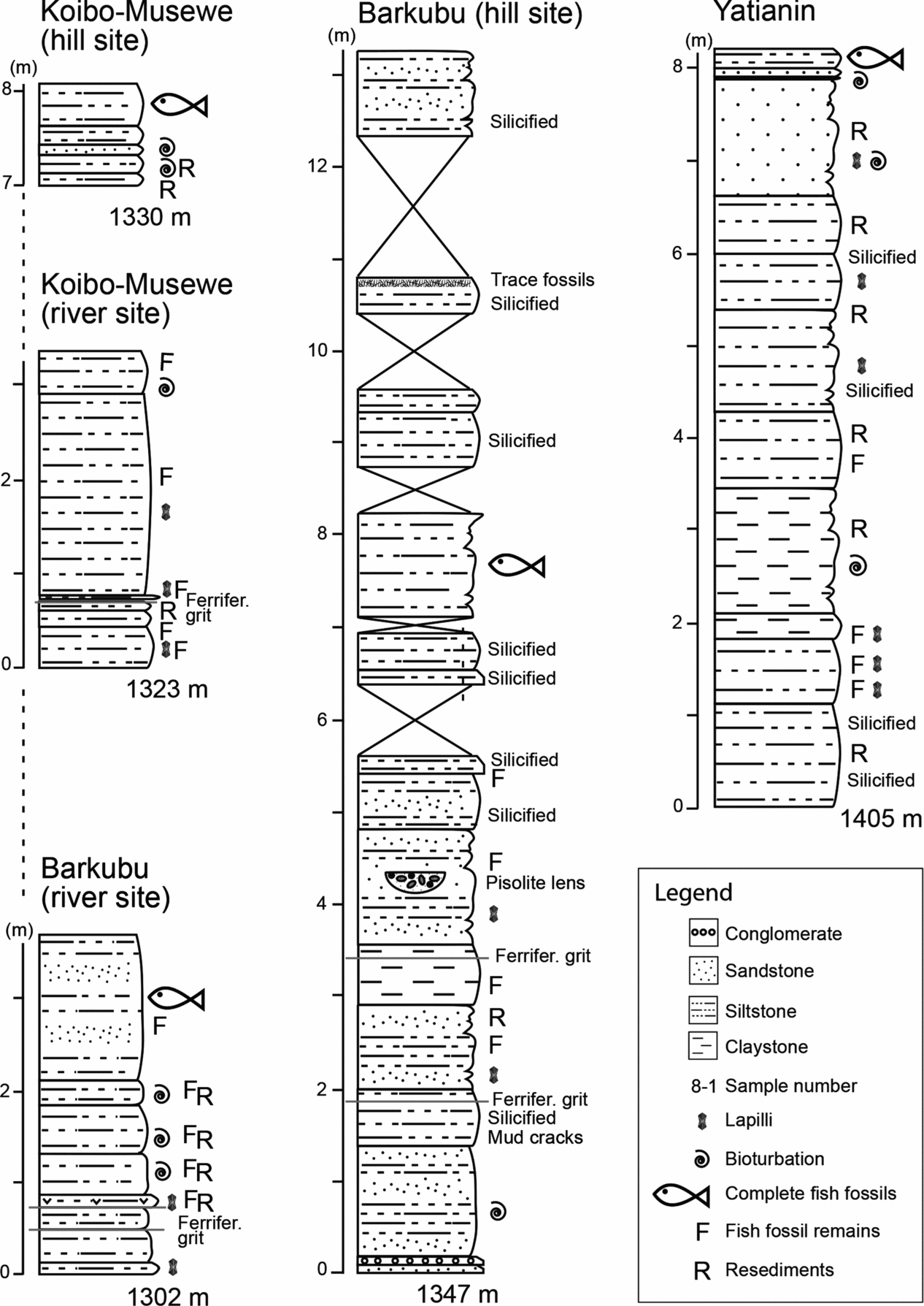
Overview of the Koibo–Mesewe, Barkubu and Yatianin (Area II) sections showing lithofacies and fossils. Altitudes refer to metres above sea level.

5.d.1. Sedimentary sequence and occurrence of fossils
The lower section is c. 3.4 m thick and comprises an alternation of grey–green, homogenous, laminated or cross-bedded siltstones (0.80 m) with some lapilli, resediments and isolated fish remains; a thin ferriferous layer is intercalated in the uppermost part. Above this follows a grey–yellow-brownish homogenous siltstone (2.15 m) with lapilli and numerous fragments of fish skeletons. The uppermost bed consists of a grey–white laminated siltstone (0.45 m) which harbours further fragmented fish remains; signs of bioturbation appear in its uppermost part.
The upper section (after a gap of c. 4 m) is c. 1.5 m thick. At its base is a grey–beige siltstone grading upwards to fine-grained sandstone with wavy lamination and some resedimented greenish clay (0.15 m). Above follows a coarsening-upwards succession of siltstones (green, grey and yellow) and then fine- to medium-grained sandstones (0.32 m), partly laminated and partly bioturbated. A green–grey, homogenous, silty claystone (0.2 m) and white–yellow siltstone (0.45 m) overlie this succession, and the latter yielded several articulated fish specimens (Fig. 5c).
5.d.2. Interpretation
The dominance of siltstones and the presence of resedimented material, lapilli and mostly isolated fish remains argue for a floodplain environment for the lower section and the base of the upper section. Water depth then increased and a lacustrine environment developed, as indicated by claystone facies and the occurrence of articulated fish fossils. No lapilli are present in these lacustrine sediments, implying that the volcanic activity may have ceased.
5.e. Barkubu section
The Barkubu section consists of two outcrops (Fig. 7). The Barkubu river site (1302 m asl) lies on a riverbank, while the Barkubu hill site is located in the hills some 40 m above the river (1347 m asl). All layers dip c. 15° to the west.
5.e.1. Sedimentary sequence and occurrence of fossils
The Barkubu river sequence is 3.6 m thick, and comprises (from bottom to top) a partially laminated, partially bioturbated siltstone succession (2 m) that contains lapilli in its lower part; some disarticulated fish remains are present throughout the section. Above it follows an alternation of brownish siltstones and poorly sorted, fine- to coarse-grained sandstones (1.6 m). Several fragments of articulated fish fossils were recovered here.
The Barkubu hill site exposes a 13-m-thick succession. At the bottom of the section are thin beds of sandstone and conglomerate (each 0.10 m), which are overlain by green–grey, weakly laminated and partly bioturbated clayey to sandy siltstones (1.2 m). Above follows a succession of grey, laminated, partially silicified siltstones (c. 0.6 m), in which a distinctive bed marked by mud cracks, a thin (0.01 m) level of ferriferous grit and a thin (0.02 m) layer of poorly sorted, fine- to coarse-grained sandstone are intercalated. Section-upwards this is followed first by siltstone with some lapilli then claystone (1.5 m altogether); isolated fish remains occur throughout this part of the profile. A thin lens (0.02 m) of poorly sorted silty sandstone and a thin level of ferriferous grit are intercalated in the claystone. The claystone is overlain by a grey, non-laminated sandy siltstone (1.25 m) containing some isolated fish remains and lapilli. The most conspicuous feature of this layer is the intercalation of a pisolithic sandstone lens (5.7 m lateral extension, 0.14 m thick). There follows a homogenous alternation (8.4 m) of mostly silicified fine-grained sandstones, siltstones and diatomites, partially laminated, beige–grey or yellow–white in colour. Articulated fish fossils, mostly poorly preserved and incomplete (Fig. 5d), were collected from two diatomite beds within the upper part of the Barkubu hill site (Fig. 7).
5.e.2. Interpretation
The variety of lithofacies and the presence of resedimented material, lapilli and a pisolithic lens, as well as traces of bioturbation, mud cracks and the scarcity of fish fossils, all suggest a dynamic palaeoenvironment, most likely within a shallow lake. However, there are no indications of abrupt change in water depth (all sediments are comparatively fine grained). Lapilli inclusions suggest volcanic influences throughout the section. The strong silicification in the upper part of this section may be linked to alkaline lake water. Quartz dissolves when waters become alkaline (with a pH>9), and amorphous silica can precipitate when the pH drops as a result of rainfall or renewed river influx or dissolved volcanic ash (Hay, Reference Hay1968; Van Couvering, Reference Van Couvering1982; Frogner Kockum, Herbert & Gislason, Reference Frogner Kockum, Herbert and Gislason2006).
5.f. Yatianin section
The Yatianin section (1405 m asl) is located on the slope of a hill. The beds strike approximately 260° in a north–south-aligned direction and dip 15° to the west.
5.f.1. Sedimentary sequence and occurrence of fossils
The section exposes c. 6.6 m of grey, brown, green and white claystones and siltstones that are either unbedded or laminated and partially silicified. Clayey resediments (pebbles of c. 3 mm or lenses up to 6 cm), lapilli and fish remains are present in places. Some mottled layers suggest pedogenic overprinting and some layers reveal traces of bioturbation. A fine- to medium-grained brownish sandstone (c. 1.2 m) overlies the silts and clays; resediments, lapilli and bioturbation are abundant in this sandstone. Above follows a white–yellowish, laminated and silicified siltstone (0.2 m), bearing mostly well-preserved articulated fish fossils (Fig. 5e, f).
5.f.2. Interpretation
Lapilli inclusions suggest volcanic influences throughout the section. The abundance of resediments and bioturbation, as well as the presence of isolated fish remains, suggest low water depths and the effects of water currents on the lower two-thirds of the Yatianin section. The absence of fossils other than fishes argues for the existence of a shallow lake rather than a floodplain (where remains of terrestrial vertebrates should be present) during this interval. The lacustrine setting was later replaced by fluviatile deposits, as evidenced by the sandstone layer (Fig. 7). An abrupt change in water depth and anoxic bottom conditions followed, as demonstrated by the articulated fish fossils in the siltstones immediately above the sandstone.
5.g. Sagatia section
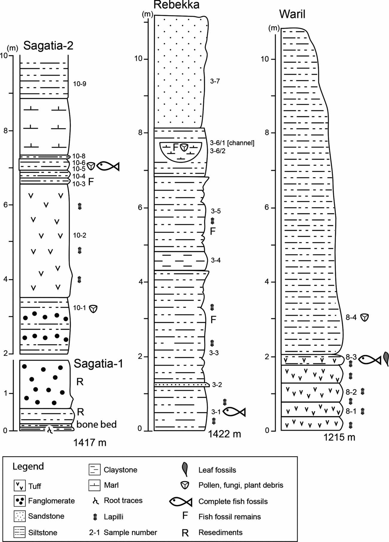
The Sagatia section comprises a c. 10-m-thick composite section consisting of two outcrops, Sagatia-1 (1417 m asl) and Sagatia-2 (1419 m asl) (Fig. 8). The latter is located c. 100 m to the southeast of the former. The two sites can be correlated by a characteristic fanglomerate. All beds lie horizontally.
Overview of the Sagatia, Rebekka and Waril (Area II) sections showing lithofacies and fossils. Altitudes refer to metres above sea level.

5.g.1. Sedimentary sequence and occurrence of fossils
The 1.9-m-thick succession of Sagatia-1 reveals a whitish–greyish siltstone (0.1 m) characterized by frequent root traces. Above follows a thin bone bed (0.1 m) consisting of numerous isolated fish remains, algal crusts and trace fossils embedded in a brownish clayey siltstone. The bone bed is overlain by a greenish, poorly sorted silt- to claystone (0.4 m), above which is a fanglomerate (1.3 m) with several reworked silt- and claystone lenses.
Sagatia-2 is 8 m thick and starts with a 1.5-m-thick alternation of grey siltstone and fanglomerate (no. 10–1). This is followed by 3 m of light grey tuffs (no. 10–2), compacted and laminated in the lower part, with some lapilli. The tuff is overlain by a 0.76-m-thick beige–purple siltstone succession composed of four distinctive layers (from bottom to top): (i) 0.16 m of laminated siltstone with some isolated fish remains (no. 10–3); (ii) 0.21 m of unbedded siltstone lacking fossils (no. 10–4); (iii) 0.3 m of laminated siltstone with articulated fish fossils (nos 10–5, 10–6); and (iv) 0.1 m unbedded siltstone without fossils (10–8). This followed above by a homogeneous brown marl (1.5 m). The top-most layer is composed of green–beige, partially laminated silt- and claystone with some lapilli (no. 10–9, 0.8 m exposed). Several fish specimens were collected from the laminated siltstone, many of which exhibit a well-mineralized scale cover (Fig. 5g); two individuals were almost complete.
5.g.2. XRD analysis
The bulk-rock analysis from sample 10.3 is characterized by a high level of analcime (52%) with the other constituents – smectite (19%), k-feldspar (15%) and quartz (14%) – being less prominent. Nearly half (49%) of the clay mineral assemblage consists of smectite. Mixed-layer minerals referred to as non-regular types of illite-smectite mixed-layer components account for a further 12% of this fraction, while illite comprises 5%. K-feldspar makes up 22% and quartz 9%, whereas analcime is present only in minor amounts (3%).
5.g.3. Palynology
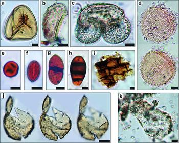
Eight samples were processed for palynological analysis (nos 10–1 to 10–6, 10–8, 10–9). Most of these were devoid of palynomorphs, but small opaque phytoclasts were found in samples 10–1 to 10–4. Only the sample from the siltstone that yielded articulated fish fossils (no. 10–6) is characterized by small numbers of well-preserved palynomorphs and NPPs. These include large and smooth trilete spores (Fig. 9a), which show great similarity to spores of Cyathea (Cyatheaceae, tree ferns), but Lycopodiaceae are also possible sources of these spores. Another fern spore (Fig. 9b) is monolete and can be attributed to the Davalliaceae or Polypodiaceae. Furthermore, some Podocarpus pollen (Podocarpaceae) are present (Fig. 9c) as well as fungal spores of the Bactrodesmium type (Fig. 9h) and unknown NPPs, possibly representing zoological remains (oocyte) or algal cysts (Fig. 9j). The sample from the siltstone above the fish-bearing layer (no. 10–8) is almost barren of organic material; however, evidence for poorly preserved Euphorbiaceae pollen of the genus Croton indicates that palynomorphs were actually deposited, but have not been preserved due to unfavourable taphonomic conditions. Moreover, some poorly preserved putative shells of testate amoebae (Fig. 9k) are noteworthy in a sample from the silt-fanglomerate succession (no. 10–1). The bowl-shaped structures may be assigned to the Difflugia morphotype.
Plant remains, pollen, spores and non-pollen palynomorphs found in the Sagatia, Rebekka and Waril sections: (a) fern spore, Cyatheaceae or Lycopodiaceae, Sagatia, no. 10–6; (b) fern spore, Davilliaceae or Polypodiaceae, Sagatia, no. 10–6; (c) pollen of Podocarpus, Sagatia, no. 10–6; (d) pollen of Croton (Euphorbiaceae); Waril, no. 8–4; (e–h) fungal spores: (e) type 1141 sensu Gelorini et al. Reference Gelorini, Verbeken, van Geel, Cocquyt and Verschuren2011, Rebekka, no. 3–6; (f) type 1077 sensu Gelorini et al. Reference Gelorini, Verbeken, van Geel, Cocquyt and Verschuren2011, Rebekka, no. 3–6; (g) Delitschia-type, Rebekka, no. 3–6; (h) Bactrodesmium type, Sagatia, no. 10–6; (i) brown, translucent phytoclast, Rebekka, no. 3–3; (j) unknown non-pollen palynomorph, probably oocyte or cyst, Sagatia, no. 10–6; and (k) testate amoebae?, cf. Difflugia-morphotype, Sagatia, no. 10–1. Scale bars: (a–i), (k) 10 μm and (j) 50 μm.

5.g.4. Interpretation
The Sagatia succession records a transition from a high-energy to a low-energy setting. The finding of putative shells of Difflugia (characteristic of lacustrine environments) in the fanglomerate-silt succession at the bottom of the profile (no. 10–1) indicates that the fanglomerate was deposited in a formerly lacustrine environment. Subsequently, the environment was strongly influenced by volcanic activity (settlement of tuffs), which probably led to the oxidation of woody material as evidenced by the presence of small opaque phytoclasts (see Section 5.g.3 above).
Starting with level 10–3, the abundance of fish fossils and the presences of tree ferns (Cyatheaceae) and Podocarpaceae indicate that the lake, its fish fauna and the surrounding vegetation recovered. The high proportion of montmorillonitic smectite in the clay mineral assemblage (no. 10–3) suggests pedogenetic weathering under warm and wet climatic conditions (Chamley, Reference Chamley1989), while the presence of Cyathea-type spores indicates a well-developed canopy and shady conditions within a wooded grassland or forest. The Bactrodesmium spore points to a woody vegetation near the riparian zone of the lake, whereas the Podocarpus pollen suggest montane but dry forests in the vicinity. The lake was alkaline, as shown by the high analcime content (52%) in sample 10–3 (Table 2), and must have been deep enough to produce episodically anoxic conditions which permitted the preservation of articulated fish fossils. This lake will have persisted for some time, but may have become shallower as indicated by the slight coarsening-upwards trend seen in the upper part of the profile.
X-ray diffraction data (relative proportions) for the samples studied.

5.h. Rebekka section
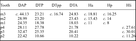
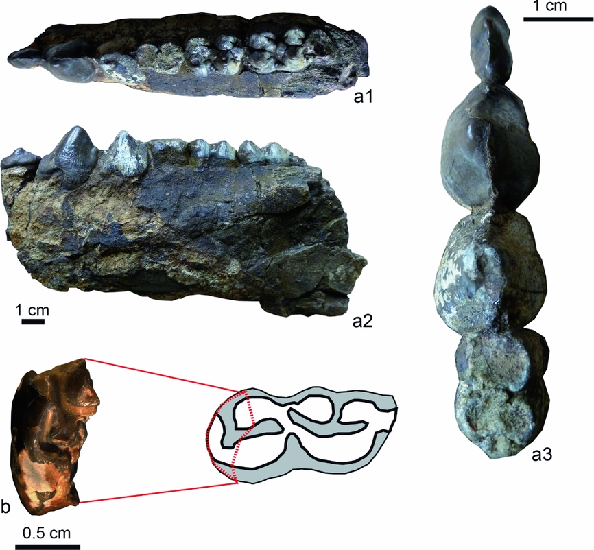
The Rebekka section (1422 m asl) is located in a canyon through which a river runs; all layers are horizontally bedded. The section begins with c. 8 m of siltstone overlain by c. 3 m of sandstone (Fig. 8). Alluvial fan deposits, about 30 m thick, then follow with an unconformity at their base (see Fig. 10). These deposits yielded a well-preserved left mandible of a suid embedded in an isolated block (see Section 8 below).

5.h.1. Sedimentary sequence and occurrence of fossils
The lowermost layer (no. 3–1, 1.2 m exposed) forms the riverbed and largely consists of a green–grey, laminated siltstone with some brown-coloured lapilli and a few articulated fish fossils (Fig. 5h, i). Overlying a thin, compact bed (no. 3–2, 0.12 m) of poorly sorted grey sandstone is a grey, partly green, compact and laminated siltstone (no. 3–3, 3.0 m) containing some lapilli. Above this is a dark brown, laminated, silty claystone (no. 3–4, 0.5 m), which is overlain by grey–green, partially laminated siltstone (no. 3–5, 2.0 m) with lapilli, intraclasts and isolated fish bones and scales. Upsection, white and brown laminated siltstone follows (no. 3–6/2, 1.3 m) in which a marly channel fill is incised (no. 3–6/1), bearing some isolated fish fragments. The topmost bed (no. 3–7, >3.0 m) is made up of a massive grey and moderately sorted silt to fine sandstone with some intraclasts.
5.h.2. Palynology
The six studied samples (nos 3–1, 3–3, 3–4, 3–6/1, 3–6/2 and 3–7) were barren of pollen and spores of vascular plants, but sample 3–3 contained some translucent cuticle phytoclasts of vascular plants (Fig. 9i). In addition, sample 3–6/1 (from the channel fill) revealed a NPP assemblage comprising different fungal spores with the Delitschia type (Fig. 9g) being most frequent. Furthermore, small ascospores that are identical to spore type 1077 of Gelorini et al. (Reference Gelorini, Verbeken, van Geel, Cocquyt and Verschuren2011) occur in this sample (Fig. 9f). Other small ascospores (Fig. 9e) can be assigned to spore type 1141 of Gelorini et al. (Reference Gelorini, Verbeken, van Geel, Cocquyt and Verschuren2011). Both spore taxa are small, one-celled, brown and ellipsoid ascospores, which are reminiscent of several fungal families such as Coniochaetaceae, Sordariaceae or Xylariaceae (Dennis, Reference Dennis1961; Hanlin, Reference Hanlin1990; Lu, Hyde & Liew, Reference Lu, Hyde and Liew2000; Petrini, Reference Petrini2003).
5.h.3. Interpretation
The occurrence of complete fish fossils at the base of the section suggests lacustrine conditions with anoxic water at the lake bottom. The subsequent disappearance of complete fish fossils, the relative paucity of fish remains and a general coursing-upwards trend all indicate a gradual transition to a better oxygenated lake or a floodplain, and eventually to fluviatile conditions. Lapilli inclusions suggest volcanic influences in the lower segment of the Rebekka section.
The almost complete lack of pollen and spores from vascular plants may indicate that the Rebekka section was located quite some distance from the shore or that vegetation was scarce because of the volcanism. The only sample that contained fungal spores comes from the channel fill (no. 3–6(1); see Fig. 8). The spore-types 1077 and 1141 sensu Gelorini et al. (Reference Gelorini, Verbeken, van Geel, Cocquyt and Verschuren2011), some representatives of the Coniochaetaceae, Sordariaceae or Xylariaceae may be present in this sample; these families are also known from modern lakes in Uganda and Kenya (van Geel et al. Reference van Geel, Gelorini, Lyaruu, Aptroot, Rucina, Marchant, Damsté and Verschuren2011). However, given the variety of possible fungi habitats, no reliable inference about the palaeoenvironment is possible. The Coniochaetaceae and Sordariaceae, as well as Delitschia-type fungal spores, are found on soils and dung while the Xylariaceae are usually wood-degrading fungi occurring in temperate to tropical regions.
5.i. Waril section
The site Waril is located west of Kaption in the Kerio Valley (Fig. 2) at an elevation of 1215 m.
5.i.1. Sedimentary sequence and occurrence of fossils
The Waril section has an approximate thickness of 11 m, and begins with a 1.8-m-thick sequence of yellow and grey, homogenous tuff with some lapilli and without internal bedding or lamination (nos 8–1, 8–2). This is followed by 0.3 m of beige–grey, finely laminated siltstones (no. 8–3), with some lapilli and numerous exceptionally well-preserved fish fossils (Fig. 5j). Fragmented fish remains and leaves also occur in this layer, but are rare overall. The topmost c. 9-m-thick bed (no. 8–4) consists of beige–grey, homogenous siltstone in which no fossil remains were observed.
A few metres above the lacustrine section is a palaeosol from which remains of crocodile and turtles, as well as a few mammal remains (often damaged), were recovered by surface sampling. Among them was a fragmentary tooth from an equid (see Section 8 below).
5.i.2. XRD analysis
The sample from the fish-bearing level (no. 8–3) from the Waril section shows a high content of analcime (42%) and a considerable amount of heulandite (30%) in the bulk-rock analyses. The other components are quartz (8%), k-feldspar (13%) and illite/muscovite (7%). In the clay mineral assemblage, smectite (17%) is the dominating clay mineral. Mixed-layer minerals (4%) and illite (8%) are the further clay mineral constituents. Analcime (36%) and heulandite (10%) remain prominent in this fraction. Further components are quartz (5%) and k-feldspar (19%).
5.i.3. Palynology
Four samples (nos 8–1 to 8–4) were analysed. Only sample 8–4 contains palynomorphs, that is, two grains of Croton pollen (Euphorbiaceae, Fig. 9d). While samples 8–1 and 8–2 have a fairly high portion of degraded organic matter (phytoclasts), sample 8–3 (fish-bearing level) is completely free of organic content.
5.i.4. Interpretation
The fossiliferous siltstone (no. 8–3) records a lacustrine environment after a period of explosive volcanism. Judging from the abundance of complete fish specimens and their excellent preservation, the lake was anoxic at the bottom and probably comparatively deep. The lacustrine setting was still influenced by volcanic activity (presence of analcime and heulandite) and the water was most probably alkaline (presence of analcime). The dominance of smectite in the clay mineral fraction points to subtropical weathering. Previous interpretation of climatic conditions was based on the leaf flora from the fish-bearing beds (Jacobs, Reference Jacobs2002; Bonnefille, Reference Bonnefille2010). Accordingly, basically open vegetation with seasonally dry periods and an annual precipitation of 500–700 mm can be assumed for Waril.
6. Lithostratigraphy and correlations
6.a. Area I
The Kelonechun section is the only studied site located in Area I. It is positioned close to the Kabasero type section (Fig. 2). Kelonechun-1 with the lahar succession and the manganese horizon exhibits characteristics that are typical of Member A (Bishop & Chapman, Reference Bishop and Chapman1970). Kelonechun-2 most probably corresponds to Member B, as prominent mud cracks (clastic dykes) have been reported only for this member (Bishop & Chapman, Reference Bishop and Chapman1970).
6.b. Area II
According to Pickford (Reference Pickford and Bishop1978), Members A and B were not deposited in Area II and Member E has been eroded. Only Members C and D should therefore be present in Area II. The facies of Member C was initially described as indicating ‘alkaline lacustrine conditions with very low energy [and] many lake level fluctuations (. . .) with possible climatic control’ (Bishop & Pickford, Reference Bishop and Pickford1975, table 2). The same authors denote the facies of Member D as recording a ‘lacustrine environment with minor fluvial episodes, some palaeosoils and desiccation cracks’. However, the later descriptions of Member C provided by Pickford (Reference Pickford and Bishop1978) and Renaut et al. (Reference Renaut, Ego, Tiercelin, Le Turdu, Owen, Andrews and Banham1999) reveal that palaeosols and desiccation cracks, as well as fine sandstone intercalations, are not restricted to Member D. In the context of our study, a more useful criterion for the recognition of Member C appear to be silicification and porcellaneous appearance of the sediments, as described by Renaut et al. (Reference Renaut, Ego, Tiercelin, Le Turdu, Owen, Andrews and Banham1999) for the upper Member C sediments in the Kapkiamu section.
Furthermore, lithostratigraphic correlations in Area II require considering the regional tectonics, as several faults to the west of the Saimo Horst or Kito Pass Fault are present (Fig. 2b). These have produced half-grabens with prominent (c. 200 m) vertical displacements, with the western blocks being upthrown relative to the eastern blocks (Chapman, Lippard & Martyn, Reference Chapman, Lippard and Martyn1973; Pickford, Reference Pickford and Bishop1978).
6.b.1. Lithostratigraphy of the Bossei section
The Bossei section is located in the south of Area II, where many graben and half-graben structures are present (Fig. 2b). It is near the Kapkiamu section described by Renaut et al. (Reference Renaut, Ego, Tiercelin, Le Turdu, Owen, Andrews and Banham1999), and shows some similarities to Kapkiamu as silicification is present. However, the thick tuff at the base of Bossei-1 has not been reported from Kapkiamu. This tuff most probably represents Member A or B, which were previously thought not to be present in Area II (Pickford, Reference Pickford and Bishop1978). Bossei-1 can therefore be interpreted with confidence as representing the base of Member C in Area II. Judging from the age data for equivalent sediments from the Kabasero type section (see Section 2.d. above) and Kapkiamu, its age is most likely to be c. 12.5 Ma (Fig. 10).
6.b.2. Lithostratigraphy of the Kabchore section
Kabchore is the easternmost section in Area II and is located close to the Saimo Fault (Fig. 2b), for which a throw of 730 m has been reported (Pickford, Reference Pickford and Bishop1978). With 1636 m asl, Kabchore is topographically the highest of the sections studied here. However, according to Pickford (Reference Pickford and Bishop1978), the Ngorora Formation in Area II is no more than 200 m thick. This implies that Kabchore has been displaced from the other sites by a further fault, which runs parallel to the Saimo Fault. Moreover, the low-energy lithofacies seen in Kabchore (see Section 5.c. above) points to its classification as Member C. We therefore assume that Kabchore is positioned in a small graben, bordered by the Saimo Fault to the east and a parallel fault to the west. Furthermore, we suggest that Kabchore can be assigned as a lower part of Member C because extensive silicification is absent. Its age may therefore be estimated as c. 12.5 Ma (Fig. 10).
6.b.3. Lithostratigraphy of the Barkubu, Koibo–Musewe and Yatianin sections
Extensive silicification and porcellaneous lithofacies were found at Barkubu (hill site) and (albeit less pronounced) at Koibo–Musewe and Yatianin. This argues for the assignment of these sections to upper Member C. Since the base of Member D, the so-called Poi Sandstone (Pickford, Reference Pickford1988), has been estimated to have an age of 12 Ma (Van Couvering, Reference Van Couvering1982; Renaut et al. Reference Renaut, Ego, Tiercelin, Le Turdu, Owen, Andrews and Banham1999), a tentative age of 12.3–12.1 Ma can be assigned to Barkubu, Koibo–Musewe and Yatianin. Based on the proximity of Barkubu to Koibo–Musewe and the altitude data, the latter probably represents a segment between the two Barkubu outcrops (river and hill site) while Yatianin may be positioned above Barkubu hill site (see Fig. 10).
6.b.4. Lithostratigraphy of the Sagatia and Rebekka sections
The geological map indicates that a fault may separate the sections Sagatia and Rebekka from those of Koibo–Musewe and Barkubu (Fig. 2b). This fault is termed Kaption Fault and has a relative throw up to 200 m (Chapman, Lippard & Martyn, Reference Chapman, Lippard and Martyn1973; Pickford, Reference Pickford1988). Westward-dipping strata at Barkubu (see Section 5.e. above) reinforces its proximity to this fault, and westward dipping of the sequence at Yatianin implies that both Barkubu and Yatianin are on the Kaption Fault's western (upthrown) side. Accordingly, the Sagatia and Rebekka sections are both located on the downthrown side of the Kaption Fault and expose significantly younger sediments than those seen at Barkubu and Yatianin. As a result, the Sagatia and Rebekka sections are correlated here with Member D in accordance with their lithofacies, which is characterized by alternations of high- and low-energy sediments (see Sections 5.g. and 5.h. above and Fig. 10). As horizontal bedding is present both in Sagatia and Rebekka, a comparison of their altitudes enables us to tentatively position them relative to each other; Rebekka (1422 m asl) is slightly younger than Sagatia (1417 m asl).
6.b.5. Lithostratigraphy of the Waril section
Waril is located west of the sections described above (Fig. 2). It has been assigned to Member D by Pickford (Reference Pickford and Bishop1978), who considered the yellow tuff beneath the fish-bearing sediments to be a possible equivalent of the golden-brown Poi tuffaceous sandstone (which he considered as the base of Member D). Waril would then represent the base of Member D, and would be roughly the same age as the Poi tuffaceous sandstone (12 Ma, see above). However, the new find of a tooth fragment from an equid in a palaeosol above the lacustrine sequence indicates that Waril most probably belongs in lowermost Member E, because equids appear for the first time in Member E (Pickford, Reference Pickford2001a ; see also Section 8 below). This interpretation is consistent with the age estimate of 9–10 Ma given for Waril in Jacobs (Reference Jacobs2002) on the basis of ‘lithostratigraphic considerations’. In addition, the fact that Waril is the youngest of the sections considered here could also explain why it is the only site at which the X-ray analysis revealed a significant amount of the zeolite heulandite, suggesting that its volcaniclastic sediments are not derived from the same source as those of Member D (Sagatia).
7. The Ngorora fish Lagerstätte
7.a. Previous research on fish fossils from the Ngorora Formation
Bishop & Chapman (Reference Bishop and Chapman1970) were the first to comment on the occurrence of complete fish fossils in the Ngorora Formation and identified them as ‘Tilapia sp.’ (Perciformes, Cichlidae). Their specimens had been collected from the ‘Kapkiamu Shales’, which represent upper Member C (see Section 6 above). Bishop & Chapman (Reference Bishop and Chapman1970) stated that all Tilapia specimens from Kapkiamu fell within the same size range (80–100 mm) and assumed that their small size may have been an ‘adaptation in an alkaline basin of limited extent’. The same fish fossils were mentioned again by Bishop & Pickford (Reference Bishop and Pickford1975) as ‘Tilapia sp. nov.’, and were finally described as a new species of Sarotherodon (S. martyni) by Van Couvering (Reference Van Couvering1982). According to Murray & Stewart (Reference Murray and Stewart1999), this species most probably belongs to the genus Oreochromis rather than to Sarotherodon.
In addition, Pickford (Reference Pickford and Bishop1978) reported that isolated remains of catfishes (Clarias sp.) and ‘Tilapia’ are common throughout the Ngorora Formation, while complete specimens of Tilapia are restricted to particular localities. He noted that each site that yielded complete fish fossils was characterized by a distinctive size of its fishes, and that size ranges of fishes are limited in all sites. As examples he mentioned Kapkiamu, where Tilapia is ‘mostly longer than 10 cm’ and Waril, where ‘all the specimens are less than 6 cm long’ (Pickford, Reference Pickford and Bishop1978, p. 257). Since the aforementioned studies, no further information on the fish fossils from the Ngorora Formation has been reported.
7.b. Systematic assignment of the fish fossils
Detailed taxonomic and systematic analyses of the fish fossils from the Ngorora Formation at the genus and tribe level are currently in preparation. Here we present a general systematic interpretation of the material.
All fish fossils recovered from the sections described above can be assigned to the family Cichlidae based on meristic counts, the occurrence of a divided lateral line and features of the caudal endoskeleton that are typical for this family. Generally, they show 11–15 dorsal fin spines, 7–11 dorsal fin rays, 3 anal fin spines and 7–10 anal fin rays. Pelvic fin formula is I/5; the number of pectoral fin rays exceeds 11 in at least some specimens. The number of abdominal vertebrae is 12–15, with 12–17 caudal vertebrae. The total number of vertebrae varies between 26 and 31.
These cichlid fossils can be interpreted as members of the African cichlids (subfamily Pseudocrenilabrinae) because (i) their age is middle–late Miocene and (ii) the split between the African cichlids and the Malagasy, Indian and South American cichlids took place long before that time, that is, during Late Cretaceous (Azuma et al. Reference Azuma, Kumazawa, Miya, Mabuchi and Nishida2008) or Eocene (Murray, Reference Murray2001; Friedman et al. Reference Friedman, Keck, Dornburg, Eytan, Martin, Hulsey, Wainwright and Near2013) time. Furthermore, several of our fossil specimens have tricuspid jaw teeth. Among the African Pseudocrenilabrinae, only the Haplotilapiines (sensu Dunz & Schliewen, Reference Dunz and Schliewen2013) possess tricuspid jaw teeth. Most of the Tugen Hill cichlids can therefore be interpreted as fossil Haplotilapiines.
Today, the Haplotilapiines include numerous tribes that have been characterized using both molecular and morphological characters (e.g. Koblmüller et al. Reference Koblmüller, Egger, Sturmbauer and Sefc2007; Dunz & Schliewen, Reference Dunz and Schliewen2013; Weiss, Cotterill & Schliewen, Reference Weiss, Cotterill and Schliewen2015). Many studies have depicted their morphological characters (e.g. Trewavas, Reference Trewavas1973, Reference Trewavas1983; Stiassny, Reference Stiassny1982; Poll, Reference Poll1986; Takahashi, Reference Takahashi2003; Koblmüller, Sefc & Sturmbauer, Reference Koblmüller, Sefc and Sturmbauer2008), but most of the recognized synapomorphies were related to soft tissue or delicate bone structures that are either not preserved or difficult to recognize in fossils. Nevertheless, our preliminary interpretation of meristic counts, the presence of cycloid scales and certain osteological characters led to the assumption that members of the Etiini, Oreochromini, Haplochromini and Tilapiini are represented among the Tugen Hill cichlid fossils. The single fossil fish species previously described from the Ngorora Formation, Oreochromis martyni (Van Couvering), is also a representative of the Oreochromini.
7.c. Abundances and size ranges of fish fossils
More than 200 articulated specimens were recovered at Waril, and a total of 299 articulated fish fossils were collected from the remaining sections (Table 3). Besides Waril, the most productive sections were Kabchore 2a-c (n = 70) and Sagatia (n = 44), while Bossei-2 (n = 27), Rebekka (n = 17) and Koibo–Musewe (river site) (n = 10) were the sites with the smallest numbers of specimens. These differences are not due to sampling bias, because outcrop conditions and time spent collecting fish fossils were approximately the same for all sites.
Ranges of total length (TL), standard length (SL), SL as a percentage of TL and body length (BL) and BL as a percentage of SL for the specimens collected from the Ngorora fish Lagerstätte in the Tugen Hills. N – total number of specimens; n (in parentheses) – number of specimens for which measurements of TL, SL and BL were possible.

Sites are listed in order of increasing stratigraphic age from Waril (youngest site, 10–9 Ma) to Bossei-1 (oldest site, 13.3–12.5 Ma). Note that 27 very small specimens (TL 1.2 cm) from Waril are not included as SL and BL could not be measured due to incomplete preservation.
Total length (TL), standard length (SL) and body length (BL) were measured for all cichlid fossils that were complete enough to make this possible (Table 3). The largest specimens originate from Kabchore 2a (TL 15.5 cm) and the Barkubu hill site (SL 14.2 cm, BL 9.3 cm). The smallest fishes are present in Waril (TL 1.2 cm, SL 1.6 cm, BL 0.9 cm), and another very small specimen (BL 2.2 cm) was found at the Barkubu hill site. The range of SL as a percentage of TL is 75–90%, while the range of BL as a percentage SL is 54–74% for all fish specimens.
With the exception of Waril, the sample sizes from individual sites do not permit quantitative comparisons. However, on the basis of measurements derived from at least four specimens, a tentative comparison between the means of the measured parameters across all sites is possible (Table 4). Accordingly, the highest SLmean (11.6 cm) is seen in the cichlids from the Barkubu hill site, followed by the fishes from the Kabchore sites (2a, 2c) with SLmean 9.9 cm. The lowest SLmean (5.4 cm) was obtained for the Waril sample. The highest BLmean is present at Bossei-1 (6.7 cm) and the Barkubu hill site (6.6 cm), while BLmean falls within the range 3.6–6.3 cm at the other sites. Fish sizes were therefore relatively large in the stratigraphically oldest sites (Bossei-1, Kabchore, Barkubu hill site), but no consistent trend towards diminishing size is evident across all sections because Rebekka, which is among the youngest sites, harbours large-sized specimens.
Mean and standard deviation of total length (TL), standard length (SL), SL as percentage of TL, body length (BL) and BL as percentage of SL for specimens from sites in the Ngorora fish Lagerstätte in the Tugen Hills, for which at least four specimens amenable to measurement were recovered. N – total number of specimens; n (in parentheses) – number of specimens for which measurements of TL, SL and BL were possible.

7.d. Size range of the cichlids from individual sections
Sections that yielded at least four specimens suitable for TL, SL or BL measurements are included in the following comparisons. The greatest differences (Δ, in cm) in fish sizes within an individual section are found at the Barkubu hill site (ΔBL 7.1), Waril (ΔTL 7.0, ΔSL 6.4, ΔBL 4.3) and Kabchore 2a (ΔTL 6.5) (Table 3). The size ranges represented in the other sections (from which at least four specimens could be measured) are narrower, with ΔTL 2.5 (Kabchore 2c), ΔSL ranging from 2.4 (Kabchore 2c) to 4.5 (Yatianin), and ΔBL represented by values between 0.8 (Sagatia) and 3.6 (Rebekka) (Table 3). It therefore appears that the stratigraphically older sites (Barkubu hill site, Kabchore 2a) are not only characterized by relatively large fish fossils (see Section 7.c. above), but also by greater variation in size. Moreover, size variation is not dependent on maximal fish size as broad size variation is also present in Waril, which yielded the smallest fishes.
7.e. Possible causes of fish mortality
The large size variation between fish fossils from the same bed seen in Barkubu (hill site), Kabchore 2a and Waril is suggestive of large-scale die-off of fish due to sudden catastrophic events, as such events kill all specimens regardless of age or size. The assumed mass kills of the cichlids from the aforementioned sections are most likely to be due to explosive volcanism. Even short-term ash fall can have a major impact on ecosystems (e.g. Wall-Palmer et al. Reference Wall-Palmer, Jones, Hart, Fisher, Smart, Hembury, Palmer and Fones2011; Perrier et al. Reference Perrier, Meidla, Tinn and Ainsaar2012). Dissolved ash can significantly decrease the pH of the water (Frogner, Gíslason & Óskarsson, Reference Frogner, Gíslason and Óskarsson2001), and may also account for asphyxiation of aquatic organisms. Given that the buffering capacity of a lake is rather small (Frogner Kockum, Herbert & Gislason, Reference Frogner Kockum, Herbert and Gislason2006), we conclude that the fishes in these sections were killed as a result of acidification of the lake water or died by asphyxiation. The possibility that ash fall also killed fish found elsewhere in the area cannot be excluded. However, the relatively narrow size ranges of our fish fossil samples from the other sections points to selective kills due to biotic factors.
8. Mammalian fossils
The alluvial fan deposits above the siltstone succession in the Rebekka section (see Section 5.h. above) have yielded the well-preserved left mandible of a suid embedded in an isolated block. The second–fourth premolars (p2–p4) and three molars (m1–m3) are still in situ (Fig. 11a). Taxonomic analysis of this fossil, in particular the relative dimensions of its teeth (enlarged posterior premolars, see Table 5), indicates that it most probably belongs to the early Nyanzachoerus-like species that was previously found for instance by M. Pickford at the site Koibo Chepserech in the Ngorora Formation (M. Pickford, unpub. data). A slightly younger suid, Nyanzachoerus sp. (or N. cf. tulodos), has been described from the Ngerngerwa Formation (Pickford, Reference Pickford1986). Direct comparison with this species is not possible because only two upper premolars are known, but these two teeth are similar in size to the last two lower premolars of the new find. On the other hand, the new specimen can be clearly separated from species of Nyanzachoerus that are known from deposits younger than the Ngorora and Ngerngerwa formations (Arambourg, Reference Arambourg1968; Cooke & Ewer, Reference Cooke and Ewer1972; van der Made, Reference van der Made1998; Boisserie et al. Reference Boisserie, Souron, Mackaye, Likius, Vignaud and Brunet2014) because of the dimensions of the molars and premolars. The finding of cf. Nyanzachoerus sp. therefore indicates that the alluvial fans above the lacustrine to fluvial sediments of the Rebekka section are most likely still part of the Ngorora Formation.
Measurements of the teeth of the suid from Rebekka (in mm).

Method follows van der Made (Reference van der Made1998). m – lower molar tooth; p – lower premolar tooth; DAP – anteroposterior diameter (length); DTp – transverse diameter (width); DTpp – width of the third lobe; DTA – width of the anterior lobe; Ha – height at the anterior lobe at the lingual side; Hp – height at the posterior lobe at the lingual side; Hli – height at the lingual side.
Mammal remains found in the Ngorora Formation. (a) Left mandible of cf. Nyanzachoerus (Suidae) from the fanglomerates overlying the Rebekka section in occlusal view (a1, a3) and lateral view (a2); (a3) is a close-up of dentition shown in (a1); and (b) anterior part of a hipparionine horse tooth (dp3?) from the uppermost layers of the Waril section, with tentative tooth reconstruction.

A further mammal fossil was recovered from a palaeosol at Waril (see Section 5.i. above). The bone fragment is tentatively identified as the anterior part of a lower deciduous tooth (dp3?; see Fig. 11b) of an hipparionine equid, conserving the parastyl and parts of the preflexid and metaconid. The presence of hipparionine horses in the locality is an indicator of Member E, as their first appearance has been recorded near the top of the Ngorora Formation in the Kabarsero section (Pickford, Reference Pickford2001a ). Early hipparionine horses are only sparsely documented in Africa, and their taxonomy is therefore difficult to access (e.g. Bernor et al. Reference Bernor, Kaiser and Nelson2004).
9. Discussion
9.a. Reconstruction of former lake environments
The sections Kelonechun-1 (Member A) and Kelonechun-2 (Member B) represent ancient lacustrine to floodplain environments of Area I, for which freshwater conditions can be assumed based on records of freshwater crabs and diatoms (Bishop & Chapman, Reference Bishop and Chapman1970; Bishop & Pickford, Reference Bishop and Pickford1975). The stromatolites found here could not be used as an indicator of water chemistry since they are observed in a variety of modern environments (Casanova, Reference Casanova, Frostick, Renaut, Reid and Tiercelin1986). The occurrence of fine-grained sediments, and levels with gradation, may indicate rather deep water and high-energy currents from time to time (Gawthorpe & Leeder, Reference Gawthorpe and Leeder2000).
At the beginning of Member C, major faulting occurred along the Elgeyo Fault and the Tugen Hills tilt block, and led to the development of the Kapkiamu Sub-basin (Area II) of the Ngorora Basin and Lake Kapkiamu, respectively (Bishop & Pickford, Reference Bishop and Pickford1975; Pickford, Reference Pickford and Bishop1978). Apart from Kelonechun and Waril, all studied sections represent ancient settings of Lake Kapkiamu. Van Couvering (Reference Van Couvering1982) and Renaut et al. (Reference Renaut, Ego, Tiercelin, Le Turdu, Owen, Andrews and Banham1999) suggested that Lake Kapkiamu was predominantly alkaline because analcime, which is a good indicator for alkaline conditions (Surdam & Sheppard, Reference Surdam, Sheppard, Sand and Mumpton1978), was detected in their samples. Our mineralogical analyses provide further support for this assumption, as analcime was abundant in the studied samples (Table 2). Moreover, the presence of analcime in the fish fossil-bearing sample from Waril indicated that Lake Waril was also alkaline.
Considering the thickness of the sediments (c. 200 m) that have filled the Kapkiamu Basin and the abrupt changes seen in the lithofacies of the sections here (see Fig. 10), it seems quite unlikely that Lake Kapkiamu represents a single lake as suggested previously. Instead, several separate lakes must have existed here during the deposition of Members C and D, and all of them experienced severe and often rapid fluctuations in water level and eventually dried up. Bishop & Pickford (Reference Bishop and Pickford1975) suggested ‘climate control’ as the most likely driving factor for lake-level oscillations. However, palaeosol overlaid by deep-water lake sediment (Kabchore) or palaeosol buried beneath several metres of fanglomerates (Sagatia) indicate sudden changes in basin depths (see Fig. 10). We therefore assume that synsedimentary tectonic activity rather than ‘climate control’ caused the observed changes between lacustrine, fluvial and terrestrial environments.
9.b. Reconstruction of vegetation and palaeoclimate
Fossil plants provide data on palaeoclimate and the composition and structure of the vegetation, information which is relevant for the definition and recognition of biomes (Jacobs, Reference Jacobs2004). Macrofossils mainly reflect the local vegetation, whereas the microflora of pollen and spore assemblages samples the plant cover over a wider area. Whether grasslands appeared during middle Miocene (c. 15 Ma) or late Miocene (c. 9 Ma) time with the appearance of hipparionine horses (Retallack, Reference Retallack1992), and whether or not the earliest grasslands played a role in the transition from ape to human (Hill & Ward, Reference Hill and Ward1988) are important questions in East African studies. New palaeobotanical studies of East African records of Miocene age are obviously relevant to these issues and can give a new perspective on this debate.
The Tugen Hills have yielded a rich macrobotanical record (Winkler, Reference Winkler2002). One recurring aspect of these early–late Miocene palaeofloras of Kenya is the presence of taxa related to plants found today in dry or wet forests of Central and West Africa or in the disjunct forest communities of coastal East Africa and the Eastern Arc Mountains (Jacobs, Pan & Scotese, Reference Jacobs, Pan, Scotese, Werdelin and Sanders2010). Fossil plant remains from the Ngorora Formation have been reported from the Kabasero section, and have revealed an autochthonous assemblage of leaves, twigs and fruits preserved in a volcanic ash dated to 12.6 Ma (Jacobs & Kabuye, Reference Jacobs and Kabuye1987; Jacobs & Winkler, Reference Jacobs and Winkler1992). Strikingly, this assemblage suggests a wooded savannah but it lacks grasses, and the fossils represent a forest comparable to those found in Central Africa today (Jacobs, Pan & Scotese, Reference Jacobs, Pan, Scotese, Werdelin and Sanders2010). At Waril, another locality in the Tugen Hills, slightly younger material dating from about 10–9 Ma represents a plant community dominated by a species of legume, which is indicative of a seasonally dry climate (Jacobs, Reference Jacobs1999; Jacobs, Pan & Scotese, Reference Jacobs, Pan, Scotese, Werdelin and Sanders2010). Furthermore, a late Miocene (c. 6.8 Ma) woodland to dry forest vegetation has been reported from Kapturo (Jacobs, Reference Jacobs1999). All these findings indicate that a variety of environments were present in the evolving East African rift during 13–6 Ma (Jacobs, Pan & Scotese, Reference Jacobs, Pan, Scotese, Werdelin and Sanders2010). This led Jacobs, Pan & Scotese (Reference Jacobs, Pan, Scotese, Werdelin and Sanders2010) to conclude that combined effects of global climate change and regional physiographic development were responsible for palaeoenvironmental changes among these localities, which are within 10 km of each other.
Compared to the macrobotanical record, palynological data from the Ngorora Formation are essentially unknown. For example, Bishop & Pickford (Reference Bishop and Pickford1975) noted that no pollen has been found in the Ngorora Formation. Our new palynological results may therefore provide new insights into the development of the palaeoenvironment during the Miocene Epoch of East Africa.
The palynological samples recovered from the Tugen Hills localities in our study show that the quality and quantity of palynomorphs present is indeed very low. Although organic or plant residues are included in nearly all of the samples, the taphonomic conditions were probably not conducive to preservation of palynomorphs; only plant material that is more resistant to oxidation and degradation remains. The best-preserved palynomorphs have thicker and melanized walls, and mostly consisted of fungal spores and fungal fruiting bodies or hyphae. This suggests that the depositional environment favoured the preservation of resistant fungal propagules and that taphonomic processes significantly influenced the differential preservation of palynomorphs (García Massini & Jacobs, Reference García Massini and Jacobs2011).
The evidence provided by the relatively diverse palynomorph assemblages in the sections Bossei-1 and Kelonechun-2 (c. 13–12.5 Ma) is especially important. Bonnefille (Reference Bonnefille and Whyte1984) and Retallack (Reference Retallack1992) have reported palynological data from the Chogo Clay (Fort Ternan), initially dated to 15–14 Ma (Shipman et al. Reference Shipman, Walker, Van Couvering, Hooker and Miller1981; Retallack, Reference Retallack1992) and redated to 13.7 Ma by Pickford et al. (Reference Pickford, Sawada, Tayama, Matsuda, Itaya, Hyodo and Senut2006). The palynomorph spectrum from this horizon consists of tree pollen such as Juniperus and Podocarpus, Euphorbiaceae pollen of Acalypha and Croton, as well as herbaceous pollen of Asteraceae. This is assemblage is nearly identical to the palynomorph spectra present in the Kelonechun-2 and Bossei-1 sections. According to Retallack (Reference Retallack1992), such a fossil assemblage is characteristic of a vegetation such as that found in the wetter parts of the Somalia-Masai Acacia-Commiphora wooded grassland or open patches in the grassy woodland along the Zambesi. The presence of similar Acacia bush and woodland habitats in Kenya during middle Miocene time has also been inferred on the basis of finds of dicot megafossils such as fruits, seeds, twigs and grasses (Retallack, Reference Retallack1992). Furthermore, indicator taxa such as Podocarpus also point to dry montane forests in the surrounding areas. The few specimens of grass pollen found in the Kelonechun-2 and Bossei-1 sections also indicate the presence of grasslands or grassy woodlands during the interval represented by the lower part of Member C of the Ngorora Formation. It can therefore be concluded that the vegetation did not change considerably between the Chogo Clay at Fort Ternan (13.7 Ma) and Member B and the lower part of Member C of the Ngorora Formation, respectively (c. 13.3–12.5 Ma).
Furthermore, it is striking that the quality, quantity and diversity of palynomorphs and NPPs fall significantly from the oldest sections (Kelonechun-2, Member B and Bossei-1, base of Member C, 13–12.5 Ma) through the sections of Member D (Sagatia, Rebekka, c. 11 Ma) to the uppermost part of Member D (Waril, 10–9 Ma) (Fig. 12). This may be attributable to taphonomic conditions, but it may also hint at climatic changes during middle–late Miocene time. On the basis of an analysis of leaf fossils in sections from Kabarsero (c. 12.6 Ma, Jacobs & Kabuye, Reference Jacobs and Kabuye1987; Jacobs & Winkler, Reference Jacobs and Winkler1992) and Waril (10–9 Ma, Jacobs, Reference Jacobs2002), Jacobs (Reference Jacobs2002) calculated that rainfall amounts decreased significantly between about 12.6 Ma and 10–9 Ma. While lowland to submontane forest and tropically moist or wet forest was prevalent in Kabarsero, Waril was characterized by an open, seasonally dry community (Jacobs, Reference Jacobs2002). This supports the previously mentioned suggestion that the decrease in diversity of palynomorph taxa from the older to the younger sections can be interpreted as an indicator of increasingly dry conditions. Nevertheless, this does not necessarily mean that we have a unidirectional climatic trend toward drier conditions, because vegetation was heterogeneous through time and space in the Tugen Hills during middle–late Miocene time (Kingston et al. Reference Kingston, Fine Jacobs, Hill and Deino2002).
Semi-quantitative representation of the distribution of palynomorphs (pollen, spores), fungi, testate amoebae, cuticles and epidermal cells in seven sections of the Ngorora Formation. Small dots – single specimen; medium dots – rare; large dots – common.

The occurrence of a relatively diverse fern flora, as well as some aquatic plants (Hydrocharitaceae) and epidermal cells of bryophytes in some of the studied sections (Bossei-1, Kelonechun-2, Sagatia, Kabchore), reflects the environmental conditions at these levels and indicates dense vegetation in the riparian zone of the lakes. This vegetation is comparable, for example, to the present distribution of a permanent riparian vegetation along the Awash river in Ethiopia within an Acacia-Commiphora wooded grassland (Bonnefille, Vincens & Buchet, Reference Bonnefille, Vincens and Buchet1987).
10. Conclusions
The continental sediments of the middle–upper Miocene Ngorora Formation (Tugen Hills, Central Kenya Rift, East Africa) are described based on nine newly explored sections. Eight of these are located in the Kapkiamu Basin (Area II in previous work), a sector from which only the ‘Kapkiamu section’ has previously been described in detail. The ninth is situated in the Karbarsero Basin (Area I), close to the type section of the Ngorora Formation The sections from the Kapkiamu Basin could be assigned to Member B and C (c. 12–13.3 Ma) or Member D (c. 9–11 Ma) based on lithofacies, dipping of beds, and the geological map of the northern Tugen Hills. Member C is represented, from old to young, by the sections Bossei, Kabchore, Koibo–Mesewe, Barkubu and Yatianin. Low-energy siliciclastic sediments, often with extensive silicification and of porcellaneous appearance, characterize these sections. The presence of analcime points to alkaline lake water, and intercalation of palaeosols and desiccation cracks is suggestive of several rapid oscillations of water level. The sections Sagatia, Rebekka and Waril (from old to young) belong to Member D. Their palaeoenvironmental settings are similar to those seen in Member C, but changes between lacustrine and terrestrial environments became more dynamic and high-energy deposits (fanglomerates) are also present.
The palynomorph spectrum of the sediments from Member C consists of tree pollen such as Juniperus and Podocarpus, Euphorbiaceae pollen of Acalypha and Croton as well as herbaceous pollen of Asteraceae, which is indicative of wooded grassland or grassy woodland. The wetter parts of today's Somalia-Masai Acacia-Commiphora wooded grassland or an open patch within the Zambesian grassy woodland represent possible contemporary analogues. Quality, quantity and diversity of palynomorphs were found to decrease strongly in the sediments of Member D; this may hint at increasingly drier conditions, but could also be due to taphonomic conditions unfavourable for pollen preservation. The new finds of a suid and an equid, both from the uppermost Ngorora Formation (Member D/E), may also point to a slightly drier climate at that time.
Complete fish fossils were recovered from distinct layers within the Member C and D sediments of all studied sections from Area II. They represent various lineages of the Haplotilapiini (Pseudocrenilabrinae, Cichlidae); precise taxonomic analyses are currently being carried out. The preservation of articulated skeletons suggests the presence of rather deep lakes with anoxic bottom water. The exclusive presence of cichlids and the absence of fishes suggestive of an arid climate is consistent with the tropical to subtropical wooded grassland or grassy woodland indicated by the palynological data. Fish sizes show strong overlap between the sections, with the largest specimens being between 10 and 15 cm in total length and the smallest only about 1.2 cm long. The previously asserted narrow range of fish sizes within individual sections is not supported, as the size range of the fish fossils in some of the sections (Barkubu (hill site), Kabchore 2a, Waril) is quite broad.
Several of the studied sections record evidence for abrupt changes in water depth, as indicated for example by palaeosols overlaid by deep-water lake sediments or fanglomerates. We suggest that synsedimentary tectonic activity of the Central Kenya Rift rather than climate control was responsible for these changes within the Ngorora Formation. Moreover, the repeated appearance of new stocks of cichlid fishes following the disappearance of lakes suggests that they immigrated from the river systems in the Central Kenya Rift, which may at that time have risen to the north of the Tugen Hills. This means that Lake Kapkiamu was not a hydrologically closed basin as previously assumed.
Fossils from Lagerstätten provide an important source of information that would not otherwise be available, revealing for example details of the evolutionary history of living groups and permitting the reconstruction of palaeoenvironments. Exceptional features of the Ngorora fish Lagerstätte are that it represents a combination of Concentration- and Conservation Lagerstätten covering an area of c. 15 km2, that fish fossils can be found in several strata within a c. 200-m-thick sedimentary unit and that many outcrops exist where excavation of well-preserved fish fossils is still possible. Overall, the Ngorora fish Lagerstätte owes its preservation to special taphonomic conditions resulting from the interplay of tectonics, the development of alkaline lakes and the impact of explosive volcanism. In several sections of this Lagerstätte, the broad size range of the fish fossils indicates that fish kills were related to explosive volcanism and ash fall, which led to acidification of the water and/or asphyxiation of fishes. The study of fish taphonomy in the Miocene of the Central Kenya Rift therefore yields insights into the palaeoenvironmental context under which hominid ancestors evolved, because catastrophic ash falls that resulted in mass killings of fishes must also have affected the earliest hominids.
Acknowledgements
We are very grateful to Dr Wilkister Moturi, Professor John M. Mironga and Professor Kennedy N. Ondimu (all Egerton University, Faculty of Environment & Resources Development) for their essential scientific and logistic support. We are deeply indebted to the members of the Orrorin Community Organization who helped in all aspects of the fieldwork and fish fossil collection, and to all the other Kenyan residents and politicians who assisted on our project and provided support. Sincere thanks go to Stefan Sónyi (Bavarian State Collection for Palaeontology and Geology, Munich, Germany), who contributed significantly to fish fossil preparation in the field and in the lab. We are grateful to Stefan Sónyi and Manfred Reichenbacher (Finning, Germany) for safely driving our cars in the sometimes very challenging terrains of the Tugen Hills. We greatly appreciate the scientific contribution of Dr Rainer Petschik (Institute of Geosciences, Johann Wolfgang Goethe-Universität, Frankfurt/Main, Germany), who helped with mineralogical analyses and interpretation. Our project benefited from numerous discussions with several colleagues and especially with Professor Dr Gloria Arratia (University of Kansas, Lawrence, USA), Dr Ulrich Schliewen and Dirk Neumann (both Zoological State Collection, Munich, Germany), Dr Martin Pickford and Professor Dr Brigitte Senut (both Muséum National d´Histoire Naturelle, Paris, France), and Professor Dr Matthias Hinderer (Institute of Applied Geosciences, Technische Universität Darmstadt, Germany). We thank Professor Dr Gert Wörheide, Director of the Bavarian State Collection for Palaeontology and Geology, for his kind support of the fish fossil preparation. We also thank Ambassador Binsai Chepsongol and his wife for organizing our accommodation in the Tugen Hills. Finally, we acknowledge the National Council for Science and Technology (Nairobi) for providing the Research Authorization (NCST/RCD/12B/012/54), the German Science Foundation for funding (grant number RE 1113/18–1) and two anonymous reviewers for their constructive suggestions.