Frontier studies have a long and varied history in the social sciences (Parker Reference Parker2002:371). The attraction to frontier research is understandable, given the qualities that are usually attributed to these zones. As summarized by Hamilton (Reference Hamilton, Rösler and Wendl1999:48), frontiers “are interstitial zones; they are places of skirmish and engagement, of shifting alliances and changing identity.” Thus, the examination of the territorial qualities of frontiers has the potential to tell us a great deal about the dynamic character of state formations, past and present (Donnan and Wilson Reference Donnan and Wilson1999:16; Wilson and Donnan Reference Wilson, Donnan, Wilson and Donnan1998:8–9).
In general terms, a frontier is a geopolitical zone that exists prior to the delineation of precise borders (Prescott Reference Prescott1987:1). More accurately, a frontier is a “loosely defined area or transition zone that lies between two political, administrative or cultural units of varying degrees of complexity or between one such unit and a hinterland either where no such polities exist, or where such polities do not come into direct physical contact” (Parker Reference Parker2002:373; see also Prescott Reference Prescott1987:36). The first of these frontiers conforms to Kopytoff's (Reference Kopytoff1987, Reference Kopytoff, Rösler and Wendl1999) internal frontier (a zone between two adjacent polities), whereas the latter corresponds with his external frontier (a zone formed as a result of the colonial expansion of a polity into a sparsely populated and/or less politically complex region). It is the first type of frontier, the internal frontier, which is the focus of this discussion.
Over the past few decades Mayanists have made small strides toward locating the frontiers between polities. The characterization of these internal frontiers and the frontier communities themselves has, however, lagged far behind. As a result, we continue to have a very limited understanding of how frontiers and frontier communities developed, the role that they played in inter-polity relationships, and the types of interaction that occurred between frontier communities and the heartlands of ancient Maya polities. This paper explores the nature of ancient Maya internal frontiers, with a particular emphasis on the various ways that collective memory factored into the formation and dissolution of frontier communities. Late Classic period developments at Minanha, located in the internal frontier between Caracol and Naranjo, are used to illustrate the discussion (Figure 1).
Map showing the location of Minanha and its approximate territorial limits.

ANCIENT MAYA INTERNAL FRONTIERS
Some scholars have argued that boundaries and territories are concepts that are not applicable to the ancient Maya. For example, Hammond (Reference Hammond and Culbert1991:276–277) indicates that, beyond Emblem Glyphs and a limited number of “frontier markers,” there is little indication that the Maya were concerned with “territorial integrity” or “boundary maintenance.” Adams (Reference Adams2001:349) echoes these sentiments in pointing out that there is little evidence to suggest that the Maya defended well-defined frontiers (see also Henderson and Sabloff Reference Henderson, Sabloff, Sabloff and Henderson1993:466–467). Grube (Reference Grube and Hansen2000:553) concurs, arguing that “… borders and territories … were not the emic concepts in which Maya polities defined themselves” (see also Houston Reference Houston, Inomata and Coben2006). In contrast, McAnany (Reference McAnany1995:87) posits that there is a tradition of “… hyper-boundary maintenance among high-density tropical agriculturalists [such as the Maya] who are configured in dispersed settlement arrangements.” Yoffee (Reference Yoffee and Culbert1991:293–294) agrees, suggesting that regional “sub-boundaries” were indeed important to the ancient Maya (see also Iannone Reference Iannone, Robertson, Seibert, Fernandez and Zender2006). There is, in fact, considerable ethnohistoric and ethnographic data to support these latter assertions, as well as a growing body of archaeological evidence.
Territoriality, Collective Memory, Community Boundaries, and Internal Frontiers
Restall's (Reference Restall1998:49) detailed examination of the Maya accounts of the Spanish conquest and Colonial period lead him to conclude that “[b]oth the Cah [self-governing municipal community] and Chibal [the Maya lineage, or extended family] were built upon territorial control and access to cultivable land.” According to Restall (Reference Restall1998:49–50), “… land not only sustained Cah and Chibal, but it acted as a mnemonic for collective memory; the toponyms of the countryside surrounding the community prompted remembrances of past events and present realities.” The importance of community boundaries to the Colonial period Maya is best exemplified by the documentation of territorial rights within the títulos: collections “of maps, testaments, deeds, border agreements, and every other scrap of paper referring to land that each community guarded so assiduously” (Farriss Reference Farriss1984:272). According to Restall (Reference Restall1998:56), aside from their role in territorial claims, títulos, or “primordial titles,” “are intended as repositories of community memory; they are a collective effort at recording—and rewriting—the past for the benefit of future community members.” Of particular interest are the maps that were sometimes included as part of the título submission, such as the Pepet Tsibil, which was associated with the Land Treaty of Mani. This map depicts an outer ring of towns and natural landmarks that appears to signify the territorial edges of a polity rather than an individual community (Marcus Reference Marcus, Sabloff and Henderson1993:125–126).
Other ethnohistoric data reaffirm that the Maya demarcated their community boundaries through the use of natural features such as cenotes, springs, caves, ponds, and prominent hills, as well as through the construction of artificial mounds and the erection of cross-shrines (Hodge Reference Hodge, Nichols and Charlton1997:211–212; McAnany Reference McAnany1995:87; Marcus Reference Marcus, Sabloff and Henderson1993:126; Moyes Reference Moyes, Brady and Prufer2005:291; Roys Reference Roys1943:181, 192; Trigger Reference Trigger2003:94). The ethnohistoric documents also inform us that these territorial limits were regularly surveyed by community leaders and their subordinates, and it was during these processions that both the natural and artificial features were reconfirmed as legitimate territorial markers (McAnany Reference McAnany1995:87; Moyes Reference Moyes, Brady and Prufer2005:291; Roys Reference Roys1943:181, 192). A passage from the Title of Calkini (ca. 1579–1595) provides an excellent example of the range of natural and artificial features that were employed during one such territorial procession:
On the north-east side they went to confer, beginning at Xkalakya, moving to the lagoon at Calxub, passing on to Lake Tixcum to the west of Claxub, coming out at the base of the mound of Kochyol, passing to the north of Tahpuc lake, emerging to the north of Lake Xicinchah, at the corner of the savannah at the foot of an oak tree; on the rise a cross [cruz] was planted at the foot of a calabash tree; [the boundary] continued and came out next to the savannah of Chanap, then emerging at Xnob, some distance from Matu [Restall Reference Restall1998:95].
Elsewhere in the same document territorial markers are said to include: “hills,” “forests,” “lagoons,” “end of the savannah,” “middle of the great savannah,” “edge of the forest,” and “stone mounds” (Restall Reference Restall1998:93).
Ethnographic accounts of the Tzotzil Maya K'in Krus ceremony also underscore the importance of ritual circuits in reaffirming and sanctifying community boundaries (Vogt Reference Vogt1970:43; see also McAnany Reference McAnany1995:87). Once again, both natural and artificial features were visited during the processions, including various water sources, cross-shrines, and stone mounds. It is in the formal manner in which community boundaries were demarcated where the role of collective memory becomes particularly consequential. Specifically, through the cyclically reoccurring ritual processions discussed above, collective memory was engaged to activate previously established natural and artificial features so that they could be formally reconfirmed as authentic signifiers of community limits.
Summary
Considerable ethnographic and ethnohistoric evidence exists to suggest that the Maya did recognize their community limits and that they demarcated them through the use of a variety of natural and artificial features—the territorial significance of which was inscribed into collective memory during periodic ritual processions. It seems plausible that the territorial limits of polities may have also been demarcated in some manner—as is implied by the Pepet Tsibil, which was included as part of the Land Treaty of Mani (as discussed above). Some of our more astute examinations of the Colonial era documents do suggest that the territorial limits of polities were of great concern to the Maya—these are often referred to as “provincial” territories by the colonial observers (Farriss Reference Farriss1984:148–150). Unfortunately, how these larger territories were demarcated is not always explicitly discussed in the documents themselves. Nevertheless, it would not be prudent to rule out the potential that the territorial limits of Colonial era polities were defined through the same features and processes as the better-documented community boundaries.
At the same time, it is equally important to heed Restall's (Reference Restall1998) conclusion that the emphasis placed on territoriality during the Colonial period, as suggested by the increased need to formally settle territorial disputes by conducting formal land surveys (i.e., royal and/or community circuits), and the compilation and submission of títulos and Pepet Tsibil to the authorities, was really a byproduct of increasing competition for land and the imposition of new economic and legal systems by the Spanish that required formal land agreements be drawn up. This suggests that these practices are not inherently Maya in origin (see Restall Reference Restall1998:49, 57). In fact, Restall's (Reference Restall1998:56) analysis leads him to conclude that these documents “contain some elements that are Spanish in origin, others that are indigenous, and others that so reflect the regionally varied intermingling of cultural influences that they can only be deemed, for example, Colonial Maya.”
Does this mean that internal frontiers were foreign concepts to the ancient Maya? Not necessarily. McAnany (Reference McAnany1995:88) aptly notes that there was likely a greater propensity for territorial disputes during the Classic period (a.d 250–900), given that the southern lowlands would have been densely packed with polities of varying sizes and degrees of political power. She therefore suggests that similar processions, and similar natural and artificial features, were likely used to frame territories in antiquity. There may even be epigraphic data, specifically some texts and toponyms, which refer to the types of practices that would have been part of the “royal circuits” that were used to engage collective memory in order to reconfirm territories (McAnany Reference McAnany1995:89–90). The fact that ethnohistoric data from central Mexico confirm the use of natural and artificial features such as springs, caves, ponds, prominent hills, and stone mounds in boundary and territorial demarcation processes suggests that this was a long-standing way of delineating territory that likely existed throughout Mesoamerica prior to the arrival of the Spanish (Garciá-Zambrano Reference García-Zambrano, Robertson and Fields1994; Hodge Reference Hodge, Nichols and Charlton1997:211–212; Moyes Reference Moyes, Brady and Prufer2005:291, 293; Smith Reference Smith2008:81–83; see also Henderson and Sabloff Reference Henderson, Sabloff, Sabloff and Henderson1993:454). This does not, however, invalidate the claim that issues of territoriality took on greater importance throughout Mesoamerica as a result of the imposition of Spanish legal practices. Consequently, the practices associated with demarcating territories may have become more formalized over time (Smith Reference Smith2008:83, 93).
Ultimately, the debate concerning whether the ancient Maya were concerned with their internal frontiers or not seems to turn not on whether they recognized such territorial limits, but rather on why these territorial edges were not demarcated more vigorously. With respect to this issue, two factors need to be considered. First, those who deny the importance of territoriality are likely basing their arguments on the fact that the ancient Maya do not meet their expectations when it comes to marking the edges of their territories. That is, they did not signify the edges of their polities by building defensive walls and/or establishing garrisons of armed border guards. We must keep in mind, however, that these features are characteristic of territorial/regional states, and we should expect more subtle demarcation in city-state societies, such as that of the Maya. As Trigger (Reference Trigger2003:398) underscores, frontiers and frontier control were far less developed amongst city-states, particularly because the economic system was based on the continual flow of materials between economically autonomous states—even during times of war—and because there was less concern for population control. At the same time, Trigger's (Reference Trigger2003:94) cross-cultural analysis of early states does force him to conclude that the “boundaries between early city-states were clearly demarcated by natural features, artificial markers, or walled fortifications” (emphasis mine).
The second issue revolves around the fact that arguments for or against the existence of Maya territorial limits frequently fail to distinguish between two very different types of geopolitical landscape. Specifically, those who argue that territories were poorly developed in the Maya world are more often than not focusing on the larger geopolitical landscapes that are associated with hegemonic federations and/or tribute networks (e.g., Graham Reference Graham and Sachse2006; Grube Reference Grube and Hansen2000; Smith Reference Smith2008:91). In regions supporting city-state cultures, such “territories” tend to be “patchy” in nature, as they often encompass both subordinate polities with tribute obligations, as well as autonomous polities that have no tributary commitments or that are part of a competing federation and/or tribute network (e.g., Graham Reference Graham and Sachse2006:117–119; Smith Reference Smith2003:130; Trigger Reference Trigger2003:113–119; see also Dirks Reference Dirks1987; Schnepel Reference Schnepel2002). Such “territories,” to use the term loosely, have poorly defined limits precisely because: (1) they are based on fluid sociopolitical and socioeconomic relationships that are perpetually under negotiation (e.g., tributary relationships); and, (2) they encompass a myriad of political actors spread across what is often a very large and exceedingly diverse socio-political landscape.
In contrast, those who support the idea that some approximation of a polity territory was conceived of by the ancient Maya are clearly referring to what might best be perceived as the “home” territories of individual city-states. Such territories are based on more firmly established tax obligations—rather than the considerably more contentious tribute obligations (Trigger Reference Trigger2003:375–394). For this reason, these territories are comparatively more stable—if only because the perpetuation of the state is steadfastly grounded in its ability to consistently control the political economy of its “homeland.” As a result, the internal frontiers between polity homelands have a far greater propensity to be consciously acknowledged, demarcated, and defended in some manner, when compared to the more amorphous landscapes associated with hegemonic federations and/or tribute networks. That is not to say that the internal frontiers between polity homelands were inherently stable, as they clearly were not (see below). Rather, it is simply to suggest that the rulers of individual polities had a vested interest in maintaining their home territories to the best of their abilities because this was critical to sustaining the actual foundations of their higher authority. The importance of controlling the landscapes associated with their far-flung alliance and/or tribute networks was important but far less crucial to their political stability.
Supporting the idea that territoriality was focused first on communities and then on the homelands of individual polities—rather than the geopolitical landscapes of the broader hegemonic federations and/or tributary networks—is the fact that the ethnohistoric documents throughout Mesoamerica refer to the walking of circuits defined by what are clearly locally significant landmarks (natural or artificial). The ability to activate the edges of the vastly larger geopolitical landscapes of the hegemonic federations and/or tributary networks through the use of these aforementioned practices and mnemonic devices would be virtually impossible.
Taking all of the above into consideration, the important question does not appear to be, Did the ancient Maya formally recognize the internal frontiers between city-states? Rather, the more appropriate question seems to be, how might we recognize these frontiers archaeologically?
Locating Ancient Maya Frontiers: Heuristic Devices
The most prevalent methods for determining frontier location have been through the application of either Thiessen polygons or the hexagonal lattices of Central-Place theory. In its most rudimentary form, the Thiessen Polygon method simply calls for frontiers to be drawn equidistant between centers. Fortunately, Mayanists have rarely employed the technique in such an unsophisticated manner. Rather, they have tended to use Thiessen Polygons in conjunction with other evidence, such as the distribution of Emblem Glyphs (e.g., Mathews Reference Mathews, Willey and Mathews1985, Reference Mathews and Culbert1991), environmental characteristics (Hammond Reference Hammond and Hammond1974), or the differential size and assumed political power—and hence “gravitational pull”—of individual centers (Dunham et al. Reference Dunham, Jameson, Leventhal, McAnany and Isaac1989:261; Hare Reference Hare2004). Nevertheless, Hammond (Reference Hammond and Hammond1974:322) has stressed that, regardless of the efforts made to enhance their effectiveness by combining them with complementary data sets, Thiessen Polygons remain artificial impositions on a landscape, and they therefore should only be employed as an initial guide as to where ancient frontiers might be located.
The alternative approach, Central-Place theory, creates models that are based on the premise that a settlement system will be ideally structured so that dependent communities are evenly spaced in a hexagonal pattern around a multifunctional primate center (Christaller Reference Christaller1933; Haggett Reference Haggett1966:49). Although this approach also produces somewhat artificial results, there is, in fact, plenty of evidence to suggest that the distribution of ancient Maya communities was far from random. For example, it has been demonstrated that city-state capitals are normally surrounded by a network of regularly spaced minor centers (see various papers in Iannone and Connell Reference Iannone and Connell2003). On a broader scale, it has been suggested that frontier dependencies tend to be located roughly 30 km from a city-state capital, and they are generally evenly spaced vis à vis each other (Hammond Reference Hammond and Culbert1991:278; Harrison Reference Harrison and Ashmore1981; Houston Reference Houston1993:137; Marcus Reference Marcus1973, Reference Marcus1983:463, Reference Marcus, Sabloff and Henderson1993:Figure 20; Webster Reference Webster, Feinman and Marcus1998, Reference Webster, Raaflaab and Rosenstein1999).
The 30 km distance appears to have universal significance as the distance that can normally be covered by a one-day walk (Grube Reference Grube and Hansen2000:552; Hansen Reference Hansen and Hansen2000:17; Hassig Reference Hassig1992, Reference Hassig, Raaflaab and Rosenstein1999:376; Marcus Reference Marcus2003:93). This distance may have been particularly crucial in terms of warfare (Hassig Reference Hassig1992, Reference Hassig, Raaflaab and Rosenstein1999:376). As Webster (Reference Webster, Feinman and Marcus1998:331, Reference Webster, Raaflaab and Rosenstein1999:347) points out, the average linear distance between antagonists in Classic period Maya warfare is 57.5 km. If battles tended to take place in the frontiers between city-states, as Webster suggests, this would mean that the territorial limits of individual city-states fell somewhere close to the proposed 30-km limit (see also A. Chase and D. Chase Reference Chase, Chase, Ruiz, Marquínez, Campillo, León, García-Gallo and Castro1998:18). It is important to point out, however, that cross-culturally the 30-km radius approximates the edge of the largest city-state territories, with most city-states historically controlling a much smaller realm (c.f., Charlton and Nichols Reference Charlton, Nichols, Nichols and Charlton1997:7; A. Chase and D. Chase Reference Chase, Chase, Ruiz, Marquínez, Campillo, León, García-Gallo and Castro1998:18; Hansen Reference Hansen and Hansen2000:17; emphasis mine).
Summary
The aforementioned approaches to delineating territorial limits are all somewhat artificial in the end. However, they are still useful as heuristic devices in that they do provide us with rough approximations for the locations of internal frontiers. These approximations can then be evaluated further by searching for a range of material correlates that are normally attributed to frontiers and frontier communities.
The Material Correlates of Ancient Maya Frontiers
There are a variety of material correlates that have been advanced as probable indicators of ancient Maya frontiers. Some cues can be gleaned from the ways that smaller-scale community boundaries were demarcated. Examples of such markers include stone walls (Kurjack and Andrews Reference Kurjack and Andrews V1976:323), the rubble mounds at Sayil (Dunning Reference Dunning1992:120–121; McAnany Reference McAnany1995:89; Tourtellot and Sabloff Reference Tourtellot and Sabloff1988), the earthworks at Tikal (Fry Reference Fry and Sabloff2003: 144–155, 169; Grube Reference Grube and Hansen2000:554, 556; Haviland Reference Haviland and Sabloff2003:134–142; Puleston and Callender Reference Puleston and Callender1967; Webster et al. Reference Webster, Murtha, Straight, Silverstein, Martinez, Terry and Burnett2007), the moats and walls at Becan, Oxpemul, Ek Balam, Yaxuna, and Uxmal (Grube Reference Grube and Hansen2000:554; Webster Reference Webster, Feinman and Marcus1998:324–325, Reference Webster, Raaflaab and Rosenstein1999:343–344), and the hilltop stelae surrounding Copan (Fash Reference Fash1991a:101; Sharer Reference Sharer1994:316; Spinden Reference Spinden1913). The question remains, however, were larger scale territories signified the same way? This question is not so easily answered.
As Olivier de Montmollin (Reference de Montmollin1988:164) points out, “boundary definition problems increase with scale.” Compounding this problem is the fact that there has been little concerted effort to isolate the territorial extremes of city-states archaeologically. The most common approach has been to use zones of declining settlement density to determine territorial limits (de Montmollin Reference de Montmollin1988; Ford Reference Ford1986; Fry Reference Fry and Sabloff2003: 144–155, 169; Grube Reference Grube and Hansen2000:554, 556; Haviland Reference Haviland and Sabloff2003:134–142; Hutson et al. Reference Hutson, Hixson, Magnoni, Mazeau and Dahlin2008; Puleston Reference Puleston1973; Puleston and Callender Reference Puleston and Callender1967). Nevertheless, there is a whole range of data sets that can be marshaled to this task. If we use the ethnohistoric, ethnographic, and comparative central Mexican examples as guides, along with the ethnohistoric and ethnographic evidence from the Maya themselves (see above), it is likely that the ancient Maya delineated city-state frontiers through a combination of natural features, such as prominent hills, caves, and water sources (e.g., cenotes, springs, ponds), edges of forests and savannahs, significant trees, and artificial features such as stone mounds and cross-shrines (Grube Reference Grube and Hansen2000:555–556; Hammond Reference Hammond and Hammond1974:322; Marcus Reference Marcus, Sabloff and Henderson1993:126; McAnany Reference McAnany1995:87; Roys Reference Roys1943:181, 192; Trigger Reference Trigger2003:94). Unfortunately, some of these markers will be difficult, if not impossible, to relocate (i.e., edges of forests and savannahs, prominent trees, cross-shrines).
The extent of causeway systems, such as those located in the northwest Yucatan and at centers such as Caracol, Yaxha, and Coba, also has the potential to inform us as to the limits of communities and/or territories (A. Chase and D. Chase Reference Chase, Chase, Inomata and Houston2001; Grube Reference Grube and Hansen2000:554; Dunning Reference Dunning1992:143–149; Kurjack and Andrews Reference Kurjack and Andrews V1976; Shaw Reference Shaw2001). As Kurjack and Andrews (Reference Kurjack and Andrews V1976:323) conclude, these causeways “… must have constituted permanent markers attesting to the relationships between dominant centers and satellite settlements.” They are therefore interpreted as a sign of increasing “boundary maintenance” activities, a process which, according to Kurjack and Andrews, eventually culminates in the construction of stone boundary walls.
Other material correlates of frontiers include evidence for armed hostilities. Smith and Montiel (Reference Smith and Montiel2001:250) confirm that warfare was commonly conducted along the frontiers of ancient states. They also point out that, if frontiers remain relatively stable, the construction of fortifications may be initiated by one or both of the antagonistic polities. Unfortunately, the Maya rarely employed formalized defensive features (Adams Reference Adams2001:349). Although there is evidence for the use of earthworks, ditches, stone walls, and palisades at some centers, less sophisticated means of defense were much more common, such as the use of hedges of thorny plants, the “cultivation” of strategically positioned stands of secondary growth, or waymil, quickly erected barriers on pathways, and naturally defensible locations, such as hilltops (Iannone Reference Iannone2008; Webster Reference Webster, Feinman and Marcus1998:324–325, 328; Reference Webster, Raaflaab and Rosenstein1999:343–344). In reality, most Maya centers appear “open and vulnerable” (Schele and Mathews Reference Schele, Mathews and Culbert1991:150). Does this mean that Maya frontiers were simply demarcated in a unique manner? Or does it confirm that inter-polity frontiers were not recognized by the Maya?
Importantly, Hassig (Reference Hassig1992:33) has pointed out that the presence of fortifications does not always indicate endemic warfare, just as the absence of such features does not necessarily imply peaceful conditions. He also notes that fortifications are more common within territorial/regional states than hegemonic states, such as the city-states of the Maya (Hassig Reference Hassig1992:167). In fact, within hegemonic states frontiers are more commonly signified by an “unfortified zone” (Hassig Reference Hassig1992:33). It is clearly significant, therefore, that Kurjack and Andrews V (Reference Kurjack and Andrews V1976:319) have documented the presence of fortified centers in the frontiers between three pre-Conquest Maya states in the northwest Yucatan. Dunning (Reference Dunning1992:97) has also confirmed that “minor centers” are often strategically located at the edge of “hypothetical” Maya territories.
In terms of other material correlates, it has been postulated that frontiers will exhibit a significant degree of “hybridity” as a result of the blending of traits and affiliations (Henderson and Sabloff Reference Henderson, Sabloff, Sabloff and Henderson1993:466–467). Smith (Reference Smith2001) has recognized material cultural hybridity in the communities between Ek Balam and Chichen Itza. According to Henderson and Sabloff (Reference Henderson, Sabloff, Sabloff and Henderson1993:466), households may reflect this “blending” more readily, as they are less prone to the “noise” of elite status items and exotics, neither of which “reflect differences in cultural identity in any straightforward way.”
Alternatively, frontiers may also be characterized by emulation. Hammond (Reference Hammond and Culbert1991:281–282) notes that during periods of balkanization the rulers of frontier centers often solidified their local standing by adopting the symbols employed by polity capitals, such as stelae and public architecture. He points out that the frontier centers around Quirigua built “administrative/elite residential compounds,” comprised of multi-roomed range structures on platforms that are clearly “simpler versions” of those in the polity capital. In another example of emulation, Smith (Reference Smith2001:33–34) argues that the ball court at Yaxkukul is a scaled-down version of the Great Ball Court at Chichen Itza. He concludes that this replication is indicative of Yaxkukul's role as a frontier community between the Ek Balam and Chichen Itza polities. That the Mesoamerican ball game probably played a role in boundary maintenance lends support to this interpretation (see also Gillespie Reference Gillespie, Scarborough and Wilcox1991:34).
Summary
Mayanists have employed a number of heuristic devices, as well as a variety of material correlates, to locate ancient Maya frontiers. It is clear, however, that we require more robust theoretical and methodological frameworks through which the positions of ancient frontiers may be determined. Conjunctive approaches combining the powers of GIS, Gravity and xTent modeling, Cost Allocation and Cost Extent modeling, Spatial Clustering analysis, and epigraphic information—as has recently been presented by Anaya Hernández et al. (Reference Anaya Hernández, Guenter and Zender2003) and Hare (Reference Hare2004)—appear to be particularly fruitful. The development of a better understanding of the qualities of frontier communities would also aid in our recognition and understanding of past frontiers. It is to this latter topic that I now shift my attention.
MAYA FRONTIERS AND THE CONSTRUCTION OF FRONTIER IDENTITIES
Three of the characteristics that are often assigned to frontier communities have been alluded to in the previous discussion. These are volatility, hybridity, and emulation. Another characteristic is that of “negotiation,” which refers to the conflicts, contradictions, and accommodations that typify the hinterland/heartland relationship.
Volatility
Volatility is a quality that is often associated with internal frontiers (see above). For their part, Mayanists have long recognized the volatile character of the internal frontiers between Maya polities. Indeed, there is abundant evidence for frontier conflicts during both the Postclassic (ca. a.d. 900–1525) and Colonial periods (Farriss Reference Farriss1984:141; McAnany Reference McAnany1995:87, 89), and these are likely characteristic of the Classic period as well. The latter is suggested by the apparent frequency that small city-states located in plausible frontiers settings, such as B'ital and Ucanal, were engaged in hostilities with what were clearly more powerful polities, such as Naranjo and Caracol (e.g., A. Chase Reference Chase and Garber2004:330; Martin and Grube Reference Martin and Grube2000).
The ethnohistoric documents underscore that raids into the frontiers between polity capitals was a common occurrence (Farriss Reference Farriss1984:272; Hassig Reference Hassig1992:99; Schele and Mathews Reference Schele, Mathews and Culbert1991:245; Webster Reference Webster, Raaflaab and Rosenstein1999:348; see also Hammond Reference Hammond and Culbert1991:281). The perpetual conflict meant that guards were often stationed in the frontiers to monitor incursions and provide early warnings of attack (Roys Reference Roys1943:67, 188; see also McAnany Reference McAnany1995:89). It has also been postulated that frontier communities played key roles as staging areas and resupply points for military excursions into the adjacent frontier (A. Chase and D. Chase Reference Chase, Chase, Ruiz, Marquínez, Campillo, León, García-Gallo and Castro1998:18, 25; Webster Reference Webster, Feinman and Marcus1998:331). Although skirmishes on the roads and trails in the frontier zones were the norm (Roys Reference Roys1943:67; see also Farriss Reference Farriss1984:141, 272), in some cases these frontier disputes did escalate into territorial warfare (Farriss Reference Farriss1984:129). However, Farriss (Reference Farriss1984:129) suggests that such conflicts were generally not aimed at gaining land per se, but rather at maintaining territorial integrity. In the end, regardless of intent or intensity, the volatility of ancient Maya frontiers must have played a key role in the development of community identities within these zones.
Hybridity and Emulation
As outlined above, Mayanists have used archaeological evidence for either hybridity or emulation in their efforts to identify frontier communities (e.g., Hammond Reference Hammond and Culbert1991:281–282; Henderson and Sabloff Reference Henderson, Sabloff, Sabloff and Henderson1993:466–467). They have rarely acknowledged, however, that both processes are active in the development of frontiers identities (but see Smith Reference Smith2001). This has been demonstrated by Kopytoff's (Reference Kopytoff1987, Reference Kopytoff, Rösler and Wendl1999) seminal work on African frontiers. Specifically, Kopytoff underscores that the blending of local and immigrant cultures, the latter often emanating from multiple capitals, is key to the emergence of unique frontier communities. These communities can eventually develop into capitals of their own polities, and the cyclical process of frontier formation will begin again, as immigrants from the new capital move out and coalesce with established communities in the new frontiers. For this reason, it is not just the interstitial character of the frontier itself—and the institutional vacuum that it provides—that leads to the hybrid qualities that we often ascribe to frontier communities. The intermingling of local and immigrant cultures within frontier settings is equally important. Unfortunately, the latter process has been virtually ignored by Mayanists.
At the same time that mixing and innovation are part of the frontier experience, there are also emulative and conservative qualities to these emerging communities. As pointed out by Kopytoff (Reference Kopytoff, Rösler and Wendl1999:33), “inherent in the frontier process is a certain level of cultural conservatism. The [frontier inhabitants] see themselves as being innovators, free to construct what society they will, but in reality they bring to the traits of social construction a given cultural baggage: a technological tradition, assumptions about the human nature of political [life], notions of legitimacy, conceptions of power and authority, principles of institution building, and so on.” This “cultural baggage,” which Kopytoff (Reference Kopytoff, Rösler and Wendl1999:34) equates with “political culture,” manifests itself in the form of “ideal patterns and ideal institutional models, rather than being a matter, as in the [capitals], of active practice.”
Once again, it is here where the concept of collective memory has particular value. Because the ideal patterns and institutional models are so widely shared, they provide a template that is utilized by the various groups that share the frontier, allowing them to fuse into what Kopytoff (Reference Kopytoff, Rösler and Wendl1999:34) calls “composite frontier communities.” As Kopytoff points out, this shared, albeit “ideal,” charter “facilitates interaction, mutual understanding, and common cultural construction.” Collective memory thus serves as a form of connective structure “involving particular sets of practices like commemoration and monument building and general forms like tradition, myth, or identity” (Olick and Robbins Reference Olick and Robbins1998:105–106).
The Kopytoff model provides a plausible explanation for why there is such a high degree of structural similarity in sub-Saharan social and political institutions (Wendl and Rösler Reference Wendl, Rösler, Rösler and Wendl1999:5). It may also explain the relative structural conformity exhibited by the myriad of city-states that made up the Classic Maya world. In neither case does emulation appear to signify a simple transfer of ideals from the capital to the frontier. In fact, one should not underestimate the complex processes that may underlay the practice of emulation. As Stein (Reference Stein2002:907–908) stresses, “we need to focus on comparing the social contexts in which the foreign material culture, knowledge, or symbols were or were not used as a way to understand its symbolic importance and its relation to broader-scale aspects of political economy.” In his consideration of the matter, Kopytoff (Reference Kopytoff, Rösler and Wendl1999:41) concludes that, “The issue … is not whether the frontier is innovative or conservative. It is rather how faithfully the political culture of the metropoles is reproduced on the frontier and how far it becomes modified by frontier circumstances.” Emulation can therefore not be read simply as a signifier of core dominance (see also Smith Reference Smith2003:137). Immigration, cultural coalescence, and collective memory also contribute to the emulative process.
Negotiation
The process of negotiation and its role in creating unique frontier identities is a topic that has only rarely been addressed by Mayanists. Stuart (Reference Stuart, Sabloff and Henderson1993:332) has, however, suggested that one of the potential causes of “pre-collapse” tensions was the need for “principal rulers to establish and strengthen the frontiers of their territories—which in turn led to the growing prominence of political subordinates.” Kopytoff's (Reference Kopytoff, Rösler and Wendl1999) frontier model is particularly valuable here because it highlights the key role that such negotiations play in the development and perpetuation of frontier communities.
Frontiers are unique places precisely because they are components of the state, but at the same time they exhibit a degree of spatial separation from the state's administrative apparatus (De Atley Reference De Atley1984:5). This does not mean that early states had no interest in developing greater command over their frontiers, but rather that, because frontiers were spatially insulated from polity capitals, exercising control over them was inherently difficult. The desire to bring frontiers and frontier communities more firmly within the ambit of the administrative apparatus may result for a variety of reasons. Within Mesoamerica it was often these regions that were required to increase their production through terracing and other more intensive farming methods to meet the tributary demands of the polity capital (Smith and Montiel Reference Smith and Montiel2001:249). In other instances administrative components were established in the frontiers to regulate trade and the movement of people, or to facilitate territorial expansion (Trinkhaus Reference Trinkhaus, Atley and Findlow1984:33). The role that frontiers play as the first line of territorial defense and/or as a symbol of state power should also not be underestimated. As noted earlier, it is clearly significant that it is the frontiers between polities where both territorial warfare and/or small scale raids tend to be focused (Hassig Reference Hassig1992:99). Most significantly, frontiers may require administration because they are home to people who are part of “political institutions and informal networks” that “compete” against the state (Wilson and Donnan Reference Wilson, Donnan, Wilson and Donnan1998:10). Lest we forget, frontier communities and their leaders have their own agendas, many of which conflict with those of the polity capitals. This is where the process of negotiation becomes particularly relevant.
The hinterland/heartland relationship is best understood through models that accommodate the fact that frontiers are both peripheries and centers (Crumley Reference Crumley and Schiffer1979:157). Of considerable importance here is the work of Victor Turner, who “highlighted the anti-structural qualities of liminality and communitas (‘betwixt and between’) that allows for both challenging and reconfiguring the boundaries of existing orders” (Wendl and Rösler Reference Wendl, Rösler, Rösler and Wendl1999:2). The crux of the argument is that, although the rulers of ancient polities had to contend with a myriad of adversaries in their efforts to maintain control of their regimes, the leaders of frontier communities would have been particularly difficult to keep in check, if only because their distance from the polity capital afforded them a significant level of autonomy (Browman Reference Browman and Manzanilla1997:230; Canuto and Bell Reference Canuto and Bell2008; Dunning Reference Dunning1992:150; Hare Reference Hare2004). For example, in his discussion of the “jungle kingdoms” of East India, Schnepel (Reference Schnepel and Quigley2005) underscores that the distant and inhospitable nature of the frontier between established states meant that these regions could serve as crucial buffer zones controlled by the allies of a particular state or, alternatively, as zones where aspiring kings could relocate to establish their own semiautonomous kingdoms (see also Quigley Reference Quigley and Quigley2005:17).
In discussing the negotiated aspects of the frontier/heartland relationship, Smith and Montiel (Reference Smith and Montiel2001:249) underscore that, because patrons often have to placate subordinate elites located along their frontiers, these zones are likely places for the emergence of “client states” that are only weakly controlled by the polity capital. The indulgence of frontier elites is often reflected in the emulation of regnal styles in the frontiers, as well as the presence of prestige imports from the polity capital (Smith and Montiel Reference Smith and Montiel2001:150). Nevertheless, when interpreting the presence of these prestige items in the frontiers, it is important to remember that they are usually firmly entrenched in the collective memory of a regional population, and they are therefore viewed as appropriate symbols that are often adopted by the frontier elite precisely because they are widely accepted as being “prestigious.” Their use outside the heartland should therefore never be simply equated with strong political control and/or integration on the part of a polity capital (Smith and Montiel Reference Smith and Montiel2001:250).
Finally, because they are often located between competing polities, frontier communities and their leaders often have the ability to ally themselves with the polity that is most beneficial to local power structures and institutions and/or the polity that has taken the upper hand in a territorial dispute (Hassig Reference Hassig1992:98). Such shifting of alliances, which may happen many times, will eventually enhance the hybrid qualities of frontier material culture assemblages. Ultimately, these shifting alliances lead to the formation of new holes in the “swiss cheese” of the broader geopolitical landscapes associated with specific hegemonic federations and/or tributary networks.
Summary
Because of their unique spatial and sociopolitical positions vis à vis the heartlands, frontiers were one of the main regions from which political dissent emanated in early states. Thus, rulers needed to maintain some degree of control over these regions in order to guarantee the political stability and territorial integrity of their polities. Because the true power of the leaders of most early states was limited, the constant negotiation required to maintain the loyalty of frontier communities and their leaders—which manifests itself in the form of indulgences, strong-arm tactics, or a combination of both—eventually sowed the seeds of independence and political realignment. As Parker (Reference Parker2002:374) concludes, “it is often interaction taking place outside the core polity—in the frontier—that influences and often precipitates change in the center …. The formation of complexity in regions peripheral to core polities [is] the most likely location for the formation of new core polities ….”
MINANHA: A CASE STUDY
My own interest in frontiers and frontier communities derives from my ongoing investigation of the ancient Maya center of Minanha, located in the rugged north Vaca Plateau of west central Belize (Figure 1) (Iannone Reference Iannone2005). Minanha itself meets a number of the criteria for a frontier community. For one, it is medially positioned between the powerful and antagonistic city-states of Caracol and Naranjo. Its 25-km distance from the capitals of these two polities also conforms to the roughly 30-km radius expected for the largest city-state territories (Charlton and Nichols Reference Charlton, Nichols, Nichols and Charlton1997:7; Hansen Reference Hansen and Hansen2000:17). In terms of its strategic value, Minanha is located atop a prominent hill, at the junction of four important valley passes. One of these valleys leads north towards the Belize Valley, another extends west toward the Peten, a third stretches northeast toward the Macal River, and a fourth runs south, deeper into the plateau toward Camp 6 and eventually Caracol. Recent research in the vicinity of Minanha has also located what appears to have once been a large aguada, a crucial resource given the paucity of surface water in this karstic environment (Primrose Reference Primrose2003; see also McAnany Reference McAnany1995:87).
The Minanha Royal Court
Minanha itself was one of the largest, if not the largest Late Classic period community in the north Vaca Plateau. Its period of florescence was, however, rather brief. Although there is evidence for occupation going back at least as far as the Middle Preclassic (ca. 600–300 b.c.), it was not until the eighth century a.d. that Minanha emerged as the seat of a fully functional “royal” court. The establishment of this “royal” court is evinced by the construction of a large court complex on the most prominent hill in the area (Figure 2).
Rectified isometric plan of the Minanha epicentral court complex.

Before proceeding to discuss this court complex in more detail, it is important to point out that when I refer to Minanha's “royal” court I am using the concept in its broadest sense—to refer to a court headed by a “king.” My perspective is grounded in the belief that in most city-state contexts there were a myriad of “kings,” all of whom were ranked in relation to each other. For this reason, kingly rights and privileges were not, in my view, confined to the largest and most ostentatious centers. Rather, the essence of kingship was diffused throughout the sociopolitical landscape through the formation of alliances, the performance of service, the gifting of emblems and symbols of authority, and the successful cultivation of legitimacy on the part of subordinate lords. In terms of the ancient Maya, the epigraphic record and material culture distribution patterns are both consistent with a more diffuse system of authority grounded in strategies of service and gifting.
The nature of such kingly hierarchies has been lucidly articulated in the “great king-little king-jungle king” model that has been explicitly crafted to capture the dynamic sociopolitical landscapes of south and east India (Schnepel Reference Schnepel2002, Reference Schnepel and Quigley2005; see also Berkemer Reference Berkemer1993:13; Dirks Reference Dirks1987). Within this model, “great” kings are those rulers who are eligible to possess all of the potential royal titles (Dirks Reference Dirks1987:65; Schnepel Reference Schnepel2002:62). Schnepel (Reference Schnepel2002:82) also underscores that the classification of a kingdom, or king, as “great” is not necessarily based on the size of the realm or of the population being ruled. Rather, it is based on a king's relationship with other kings who can be classified as “little.”
Berkemer (Reference Berkemer1993:13) defines “little” kingdoms in the following manner:
A political system whose ruler can regard himself as independent as regards internal politics—for example, maintaining his own army, collecting taxes, receiving tribute from smaller kings and chiefs, and bestowing titles on them—and who, in addition, pursues an independent ritual politics within his own territory, but who at the same time must recognize a politically, ritually and militarily superior overlord over him, whose authority he shares and whom he needs to legitimize his own internal rule, is to be described as a “little kingdom” (translated in Schnepel Reference Schnepel2002:81).
Finally, according to Schnepel (Reference Schnepel2002:135), a “jungle” kingdom is a special category of “little” kingdom that is defined by two primary criteria: (1) it is located in comparatively inaccessible forested and/or hilly subregions that were often considered “impenetrable” and “dangerous” and that could only be accessed with great difficulty from the centers of power of the “great” kings, as well as the other “little” kings; and, (2) the population of a “jungle” kingdoms included a high percentage of individuals of tribal origin.
Informed by this construct, I conceive of Minanha as the Late Classic home to a line of “little” kings—or more appropriately, given the frontier setting, “jungle” kings—whose kingdom was located in an interstitial zone between the realms of two dynasties of “great” kings, one dynastic line residing at Caracol, the other at Naranjo (Iannone Reference Iannone2008). I assign Minanha's rulers to this sociopolitical status because, although the Minanha court complex is a somewhat scaled down version, it still contains all of the features found in the court complexes of the aforementioned “great” kings. This implies that the same basic range of activities was carried within these various architectural spaces.
In summary, during the eighth century Minanha was likely a “peripheral” kingdom both sociopolitically and economically (i.e., it was located at a “social” distance from the “great powers”), as well as in spatial and ecological terms—given the remote and rugged character of its realm (Schnepel Reference Schnepel2002:62; cf. Dirks Reference Dirks1987:95–96). Taken together, this means that Minanha's rulers are best classified as “jungle” kings (see Iannone Reference Iannone2008).
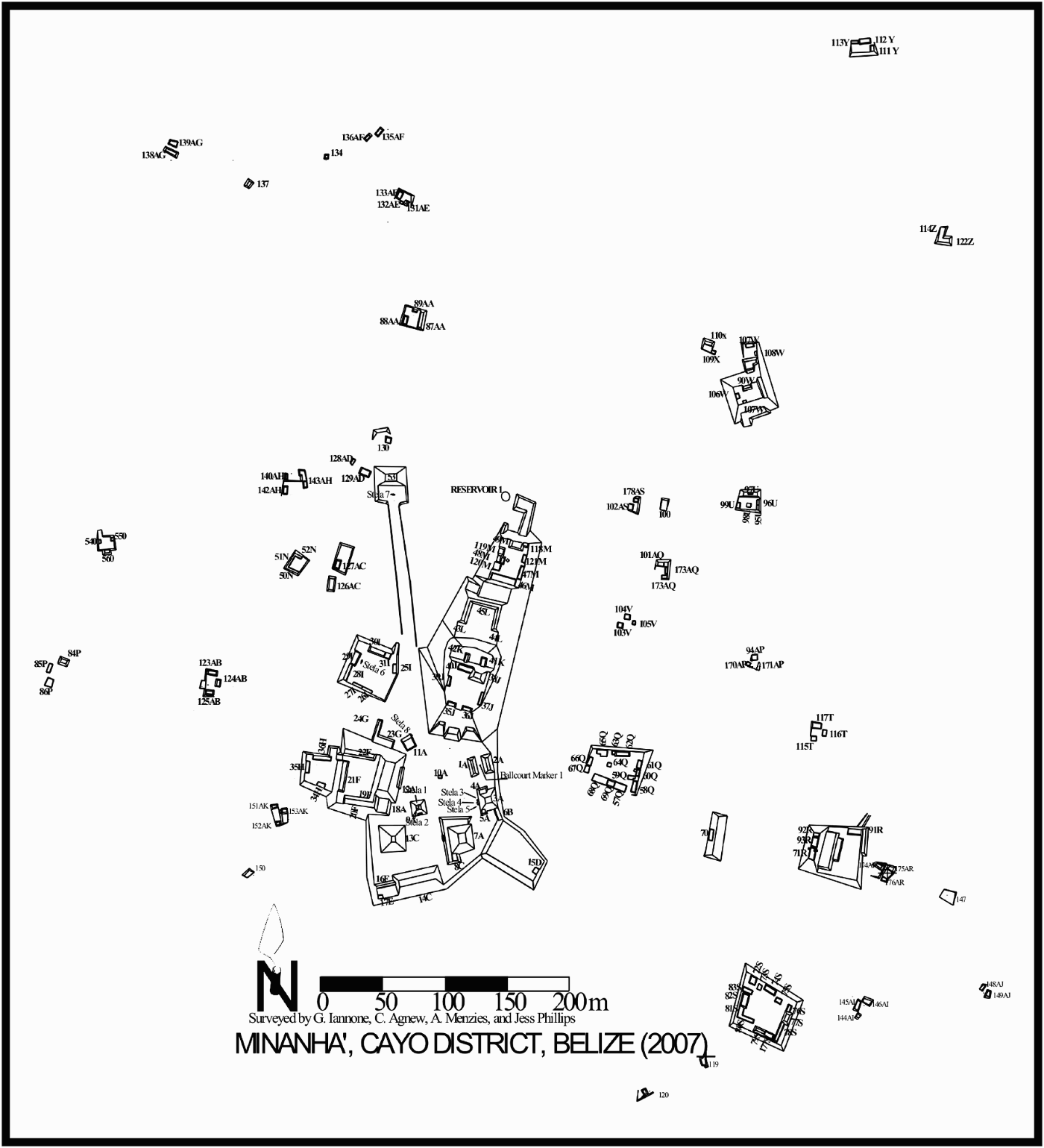
To return to the discussion of the Minanha royal court complex, it consists of two large plazas, nine courtyards, three smaller patios, a ballcourt, and one causeway termini shrine (see Figure 2). The southern portion of the epicenter was apparently civic-ceremonial in orientation, comprised as it is of large public plazas and courtyards. This is also the location of the eastern shrine complex, the ballcourt, and Minanha's more administratively orientated range-structures.
The northern portion of the court complex is dominated by a multi-level elite residential acropolis group. The focal point of this acropolis is the royal residential compound located at the southern end (Group J). When the royal court was at its peak, this royal residential group sat atop a basal platform, approximately 13 m high, which served to elevate it above the main public features of the epicenter, and which provided its inhabitants with a panoramic view of the Minanha realm. Excavations have shown that this royal residential compound included a formal, vaulted entrance on the south (Structure 35J-2nd), a throne room/royal residential building on the east (Structure 37J-2nd), a pyramidal structure, approximately 8.5 m high with rounded corners on the north (Structure 38J-2nd), a large performance platform on the west (Structure 39J-2nd), and an appended servant's area to the north (Group K; Slim Reference Slim2005). Most of the buildings associated with this courtyard appear to have been painted red, with the exception of the throne room/royal residential building, which may have been multicolored (red, green/blue, and white). There is also evidence that a stucco frieze once adorned the 38J-2nd pyramidal structure.
Eight stelae have been discovered within the court complex. None exhibit glyphic texts, although at least two may have originally been inscribed. Of the latter, one is a soft limestone monument located at the main entrance to Plaza A (Stela 8). Unfortunately, this stela is too highly weathered to allow a confident assessment of whether it originally had incised glyphs. The second is a broken slate stela (Stela 4) located on the primary axis of Structure 3A, the eastern shrine structure in Plaza A. This stela was broken off at its butt, thus we have no clue as to whether its upper portion was indeed carved. That this breakage occurred in antiquity is implied by the fact that the two “compact” limestone monuments that were associated with the slate monument were also broken off at their butts. Because these latter two monuments could not have been carved, given that they were made of extremely hard limestone, the breakage of all three monuments appears to have been a result of ancient Maya political discord rather than the actions of contemporary looters (i.e., the uncarved monuments would have held no value for looters). Significantly, destruction events are often aimed at removing key mnemonic devices from the symbolic repertoire of a community, but their past existence and significance are often maintained in collective memory for a considerable length of time following such an event—a fact that also attests to the importance that collective memory plays in the perpetuation of community histories and the production and reproduction of community identities.
The Minanha epicentral court complex, which covers 9.5 ha, is surrounded by a range of other settlement components with proposed ritual, administrative, and domestic functions (Figure 3). Although our research outside the epicenter has been limited to date, the region surrounding Minanha was apparently home to a fairly dense support population (ca. 405 people per km2 according to Connell [Reference Connell, Iannone, Primrose, Menzies and McParland2001:109]). There is evidence that this support population grew substantially with the establishment of the Late Classic royal court. The minor center of Waybil, which is located roughly 2 km south of Minanha (see Figure 1), also appears to have been oriented toward the royal seat of power at Minanha (Sam Connell, personal communication 2001). This suggests that the Minanha royal court quickly become the primary focus for a fairly large and diverse population. Significantly, reconnaissance has shown that many of the hill slopes and valleys surrounding Minanha are terraced. It thus appears that one of the means through which the newly established royal court strove to sustain itself, along with its support population, was through the construction of an extensive terrace agricultural system.
Map of the Minanha site core.

On the broader scale, the establishment of the Minanha royal court in the early eighth century would have undoubtedly resulted in the shifting of the various internal frontiers in the region. Given the propensity for employing natural features to define frontiers in Mesoamerica, it seems likely that Minanha's northern frontier would have been demarcated by the northern edge of the Vaca Plateau itself, located approximately 5 to 7 km away from the Minanha epicenter. As one of the most conspicuous natural features in the eastern Maya lowlands, the northern edge of the plateau would have served as an ideal frontier between Minanha and Xunantunich (located roughly 15 km northwest of Minanha), the latter also emerging as a small, but significant, city-state during the late seventh to early eighth centuries (LeCount et al. Reference LeCount, Yaeger, Leventhal and Ashmore2002; Leventhal and Ashmore Reference Leventhal, Ashmore and Garber2004). Minanha's eastern frontier would have also likely been delineated by another highly prominent, natural feature—the Macal River gorge. Once again, this frontier would have been situated roughly 5 to 7 km from the Minanha epicenter, and it would have served as a natural frontier between Minanha and Pacbitun, the latter located roughly 16 km northeast of Minanha. The southern and western frontiers of the Minanha polity are more difficult to isolate, but it is likely that they too would have been situated approximately 5 to 7 km from the Minanha epicenter. (The projected polity extent is depicted in Figure 1.) Although this territory may seem too small to sustain a kingdom, supporting evidence for the efficacy of such a small territory can be found in the Valley of Mexico, where city-state capitals were located on average only seven kilometers from each other (Trigger Reference Trigger2003:100).
Emulation at Minanha
Analysis of the architectural and artifactual data from eleven field seasons indicates that the great center of Caracol was a significant source of emulation for the eighth-century Minanha royal court. In recognizing this, it is important to stress that, although the following traits have wider distribution as discrete cultural practices, it is in their manifestation as a unified program of political and ritual practice at both Minanha and Caracol that is suggestive of emulation. The Late Classic Caracol-style attributes exhibited by Minanha include (1) a preference for caches and burials to be associated with eastern structures (A. Chase Reference Chase and Garber2004:328; D. Chase Reference Chase and Garber2004:344; D. Chase and A. Chase Reference Chase and Chase1996, Reference Chase, Chase and Houston1998); (2) the construction and repeated use of multiple-entry grave chambers in both the epicenter and surrounding site core (A. Chase Reference Chase and Garber2004:329; A. Chase and D. Chase Reference Chase, Chase, Chase and Chase1994a:9, Reference Chase, Chase and Fields1994b:56; Reference Chase and Chase1996:71; D. Chase Reference Chase, Chase and Chase1994:123, Reference Chase, Whittington and Reed1997:21, Reference Chase and Garber2004:340; D. Chase and A. Chase Reference Chase and Chase1996, Reference Chase, Chase and Houston1998:311); (3) the construction of grave chambers long before they were actually used (A. Chase and D. Chase Reference Chase, Chase and Fields1994b:55; D. Chase and A. Chase Reference Chase, Chase and Houston1998:311); (4) the use of slate capstones in graves (A. Chase and D. Chase Reference Chase, Whittington and Reed1987:46; D. Chase Reference Chase and Garber2004:342); (5) the carving of slate monuments (Anderson Reference Anderson1959:211; Houston Reference Houston, Chase and Chase1987:85); (6) the practice of caching crude obsidian eccentrics, speleothems, and flanged effigy censers depicting the jaguar sun god of the underworld (A. Chase Reference Chase and Garber2004:329; A. Chase and D. Chase Reference Chase, Chase and Fields1994b:57); (7) the smashing of flanged effigy censers as part of termination rituals associated with a royal funerary cult (A. Chase and D. Chase Reference Chase, Chase and Fields1994b:54, 57; Rice Reference Rice1999: 38, 43); (8) the caching of small ceramic bowls with human finger bones inside (A. Chase Reference Chase, Chase and Chase1994:166–169, Reference Chase and Garber2004:328; D. Chase Reference Chase, Chase and Chase1994:124, 129, Reference Chase and Garber2004:340); (9) the predominate use of Belize Red ceramic vessels in ritual contexts, particularly tripod plates with hollow oven feet with rattles (A. Chase Reference Chase, Chase and Chase1994, Reference Chase and Garber2004:331); (10) the use of rounded corners on raised temples (A. Chase and D. Chase Reference Chase, Chase, Chase and Chase1994a:7); (11) the widespread use of agricultural terracing (A. Chase Reference Chase and Garber2004:328, 332; A. Chase and D. Chase Reference Chase, Chase, Ruiz, Marquínez, Campillo, León, García-Gallo and Castro1998); and, (12) the construction of an ancestor shrine complex comprising of an eastern structure fronted by a slate stela and two uncarved, compact limestone stelae and a western structure with two limestone stelae on its summit (Anderson Reference Anderson1959:211; A. Chase and D. Chase Reference Chase and Chase1987:17; Grube Reference Grube, Chase and Chase1994:87).
The last trait is particularly intriguing, as it is also present at Calakmul, where the central plaza has a slate stela in front of the eastern shrine structure, and two additional stelae on the summit of the opposing western structure. The slate stela at Calakmul has a date of a.d. 662 (Stelae 9); its counterpart at Caracol carries an a.d. 702 date (Stelae 21) (see Martin and Grube Reference Martin and Grube2000:95; Reese-Taylor Reference Reese-Taylor2003). This shared pattern may be interpreted as an indication of close ties between Calakmul, Caracol, and Minanha (Reese-Taylor Reference Reese-Taylor2003). Alternatively, it may simply signify that Minanha's Late Classic royal court adopted an already accepted set of symbolic features as part of its strategy of legitimization. It is worth noting here that fragments from what may have once been a slate monument have also been recovered at Tikal (Coe Reference Coe1958:804). Unfortunately, the significance of these slate pieces remains unclear, and thus the role that Tikal may have played with respect to the use of such monuments is inconclusive.
The use of rounded corners on Minanha's 38J-2nd temple structure may be interpreted in similar fashion. On one hand, this may simply be another attempt to mimic Caracol styles. There are, however, deeper roots for this practice. At Tikal, for example, the presence of rounded corners in association with Temple V has been interpreted as a conscious effort to connect with past architectural traditions, particularly those of the Early Classic (Valdés and Fahsen Reference Valdés, Fahsen, Demarest, Rice and Rice2004:142). Thus, this architectural style was likely perpetuated in collective memory for many centuries, and it occasionally appears to have been called upon in efforts to recreate traditional, and therefore legitimate, settings for Late Classic period political and ritual praxis.
Hybridity at Minanha
The widespread use of slate at Minanha may constitute an example of frontier hybridity. Specifically, slate itself seems to have been particularly significant to the cultural identity of the Minanha royal court and those who were affiliated with it. Slate capstones have been found in burials associated with structures, particularly those located on the eastern side of courtyards, throughout the Minanha community (Schwake Reference Schwake, Iannone, Chartrand, Dell, Menzies, Pollock and Slim2002); their use does not appear to have been restricted to individuals of any particular socioeconomic or sociopolitical standing. Slate is also a common cache offering at Minanha, and slate capstones have been found in association with at least one vaulted building in the royal residential compound. These data suggest that slate held a significant place in collective memory at Minanha. Specifically, the formalized use of slate in ritual contexts throughout greater Minanha likely served to entrench a sense of shared identity within the various factions in and around the epicenter and would have been vital to the formation of the type of “composite frontier community” referred to by Kopytoff (Reference Kopytoff, Rösler and Wendl1999:34).
Slate may have also been integral to collective memory on the broader, regional scale—within the proposed Caracol/Naranjo frontier. Specifically, Minanha's use of slate appears to be both more pronounced and more formalized than is seen at Caracol (cf. D. Chase Reference Chase and Garber2004:342). It is consistent, however, with what has been documented for Pacbitun, where a slate workshop has been excavated (Healy et al. Reference Healy, Awe, Iannone and Bill1995; see Figure 1) and where slate monuments and capstones also appear to be key symbols of community identity (Healy et al. Reference Healy, Awe, Iannone and Bill1995; Healy et al. Reference Healy, Hohmann, Powis and Garber2004a:226; Healy et al. Reference Healy, Awe, Helmuth and Garber2004b:230). This shared emphasis on the political and ritual usage of slate may simply mean that the Minanha and Pacbitun economies were intricately bound to the production of slate objects. It is also plausible that, because of its use in a myriad of political and ritual events at both communities, slate may have held a key position within the collective memory of those who shared the frontier experience, and it may therefore reflect a degree of commonality in terms of cultural identity. Of relevance here is that, like Minanha, Pacbitun is also posited by some to have been positioned at the very edge of the Caracol realm because of the presence of early stelae monuments and the center's adherence to certain cultural traits, such as the construction of multiple-entry burial chambers (A. Chase Reference Chase and Garber2004:330; A. Chase and D. Chase Reference Chase and Chase1996; D. Chase Reference Chase and Garber2004:342; Healy et al. Reference Healy, Awe, Helmuth and Garber2004b; Leventhal and Ashmore Reference Leventhal, Ashmore and Garber2004:170). Nevertheless, as Healy et al. (Reference Healy, Hohmann, Powis and Garber2004a:225) point out, Pacbitun also exhibits many traits that are more indicative of the Belize River valley. This observation only lends support to the frontier interpretation (Iannone Reference Iannone2002, Reference Iannone2003a, Reference Iannone2003b).
Hybridization may also be reflected in Minanha's epicentral plan. It clearly mimics the cosmologically-based civic plan of more potent centers in that it exhibits a strong north-south axis and follows the pattern of placing the royal residential compound, Group J, in the north, in association with the heavens (Ashmore Reference Ashmore1991, Reference Ashmore, Danien and Sharer1992). In terms of the political inspiration for Minanha's epicentral plan, it appears to emulate the Calakmul-style civic plan (Mosher Reference Mosher2005), as recently defined by Ashmore and Sabloff (Reference Ashmore and Sabloff2002; see Folan et al. Reference Folan, Marcus and Miller1995). Minanha also adheres to the “temple-palace” acropoline architectural form that is prominent at both Calakmul and Caracol (Demarest et al. Reference Demarest, Rice, Rice, Demarest, Rice and Rice2004:555). At the same time, Minanha's site plan resembles even more closely that of Caracol's nemesis, Naranjo, and the latter's likely affiliate and/or ally, Xunantunich (Mosher Reference Mosher2005). The hybridity inherent in the Minanha epicentral plan suggests that its rulers sought inspiration in various established and powerful centers in the lowlands. As Ashmore and Sabloff (Reference Ashmore and Sabloff2002:203) point out, an “important means of enhancing the political aura of a place is by constructing it to resemble locales of established stature: If a place looks like a recognized seat of authority, people behave there accordingly.” This rings particularly true for a frontier center, given the importance of “ideal patterns and ideal institutional models” in the creation of composite frontier communities (Kopytoff Reference Kopytoff, Rösler and Wendl1999:34).
Volatility at Minanha
Ultimately, Minanha's Late Classic royal court would have a fleeting existence. Its sudden demise coincided with the destruction of some of the key features associated with Minanha's royal court sometime in the early ninth century. The dissolution of the royal court is best exemplified by the infilling of the royal residential compound (Group J). With the exception of Structure 38J-2nd, the upper 3.70 m of which was reused as part of an impoverished Terminal Classic (a.d. 810–900) group, the penultimate courtyard and all of the vaulted buildings associated with the Late Classic royal residence were buried beneath a deposit (ca. 4.80 m) of clean, dry-stone fill. Prior to the infilling, the courtyard and the associated rooms were swept clean, and a 10–20 cm thick lens of finely sorted sediment was laid down across all the floors and stair surfaces to protect them. The dry-stone fill was then carefully placed on these sediments so as not to damage the architecture. The large boulders and cobbles that were used in this loose fill were contained within well-built construction pens. Intriguingly, before burying the penultimate courtyard its associated rooms had been largely filled from the inside without collapsing their vaults, until a decision was apparently made to employ the upper part of the 38J-2nd temple in the terminal courtyard, at which time the very upper portions of the vaults were razed. Importantly, similar infilling of royal compounds at the onset of the Terminal Classic period has been documented at La Milpa, Lamanai, and possibly Xunantunich (Graham Reference Graham2004; Hammond Reference Hammond1999a:13, Reference Hammond1999b; Hammond and Thomas Reference Hammond and Thomas1999; LeCount et al. Reference LeCount, Yaeger, Leventhal and Ashmore2002:44; see Iannone Reference Iannone2007).
It is significant that so much care was taken to preserve the architecture during the Minanha infilling. With the exception of the partial dismantling of the 39J-2nd upper platform, some minor damage to the corners of 38J-2nd, the destruction of a stucco frieze that was likely associated with the same building, and the breakage and removal of the upper portions of the stelae associated with the Structure 3A eastern shrine (see above), there is no evidence of willful damage. Importantly, the latter two features (i.e., the frieze and the stelae) would have been key historical and ideological elements associated with Minanha's rulers. Equally significant is the fact that no new royal residence was built over the buried one, or anywhere else at Minanha, following the infilling event.
A rather impoverished Terminal Classic (a.d. 810–900) residential group was constructed where the royal residential courtyard once stood. This consisted of the reused portion of the Structure 38J pyramidal structure, the construction of a number of low building platforms with perishable superstructures, and one building with low double-faced masonry walls and benches. Importantly, one of the terraces of the partially buried 38J-2nd temple was used to define the level of the new courtyard surface, allowing the reused portion of the shrine (38J-1st) to maintain its architectural proportions. This indicates that the construction event was well-planned and that it does not represent a larger construction project that was ended abruptly. The fact that the smaller building platforms constructed on the new courtyard surface employed the thick walls of the earlier buildings as footings also implies that little time passed between the infilling of the penultimate courtyard and the construction of the various buildings associated with the terminal courtyard. Finally, the fact that the small patio that had previously served as a servant's area during the existence of the royal court (Group K) was cut off from use as a result of the infilling events suggests that the terminal courtyard was not only smaller and considerably less elaborate than its predecessor, but it was also far less diverse in terms of the range of activities that were carried out within its confines.
Summary
The infilling event clearly informs us that royal rule at Minanha came to an abrupt end early on in the Terminal Classic period. It is important to point out, however, that the demise of the royal court came prior to any significant depopulation of the surrounding community. In the end, the infilling event itself remains difficult to interpret, but it does appear to reflect a complex political process involving both antagonistic regional powers and sympathetic local labor (see Table 1).
Evaluation of the theories surrounding the infilling of Minanha's royal residential courtyard.

Negotiation at Minanha
The rapid rise and equally swift demise of the Minanha royal court is intriguing, particularly since extensive reconnaissance has shown that the north Vaca Plateau was home to relatively few large centers. At this juncture, it seems that broader sociopolitical factors may hold the key to Minanha's florescence. Minanha's frontier location also appears to have been significant to its rise in stature. Three potential interpretations are suggested: (1) Minanha was a frontier dependency within the Caracol city-state; (2) Minanha served as the semi-autonomous capital of a buffer state in between the competing Naranjo and Caracol city-states; or, (3) Minanha was the capital of an autonomous city-state.
Minanha as frontier dependency
Stuart (Reference Stuart, Sabloff and Henderson1993:324, 332, 336, 348) characterizes the eighth century as a period of decentralization and power sharing (see also Culbert Reference Culbert and Culbert1991:325; Fash Reference Fash and Fields1991b; Fash and Stuart Reference Fash, Stuart and Culbert1991:172; Grube Reference Grube and Hansen2000:560; Hammond Reference Hammond and Culbert1991:306; Iannone Reference Iannone1996:433, Reference Iannone2005; Lowe Reference Lowe1985:37–39; Marcus Reference Marcus1976:65; Martin and Grube Reference Martin and Grube2000:211; Schele Reference Schele and Culbert1991a:78, Reference Schele and Fields1991b; Webster Reference Webster2002:15–16). He also argues that this changing political climate led to an expansion in the powers of subordinate lords and greater concern for solidifying frontier regions. From this perspective, Minanha's emergence can be interpreted as evidence of Caracol's desire to strengthen its frontier with its long-standing enemy, Naranjo. It is also possible to attribute Minanha's subsequent demise to a Naranjo incursion into the Caracol frontiers later in the same century. Thus, from this view, the emulation exhibited by the Minanha royal court is a reflection of Caracol's direct control over a strategic frontier center. It would therefore fit the alternative type of “buffer state” that Schnepel (Reference Schnepel and Quigley2005; see above) discusses for East India, wherein a frontier state is allied with one specific polity.
Two lines of evidence tend to invalidate this interpretation. First, Minanha does not exhibit any signs of overt Caracol control. Most significantly, there are no monuments or inscriptions at Minanha that connect it to the Caracol city-state—although it remains possible that such a text may have originally existed on the broken slate monument in front of the Structure 3A eastern shrine. Particularly conspicuous in its absence is a giant ahaw altar, a type of monument that at the least signifies close connections to Caracol and that may be even more significant if Grube (Reference Grube, Chase and Chase1994:100–101) is correct in his assertion that Caracol awarded giant ahaw altars to its allies in appreciation for their help in warfare. If Minanha was one of Caracol's strategic frontier centers, one would expect that it would have played a key role in conflicts with Naranjo. As such, it is expected that a giant ahaw altar would be prominently displayed at Minanha. Ultimately, the lack of evidence for such a monument undermines the validity of the Caracol dependency interpretation. Finally, our excavations at Minanha have yet to produce a single sherd from a Caracol-style “facepot.” Such vessels appear to be key indicators of Caracol ethnicity and, thus, influence (A. Chase Reference Chase, Chase and Chase1994; D. Chase and A. Chase Reference Chase, Chase and Houston1998). The absence of such vessels at Minanha therefore severely undermines the dependency model.
When one considers the location of Minanha and the timing of its florescence the Caracol dependency model becomes even less viable. As noted earlier, cross-cultural analyses point to 30 km as being the maximum radius of a city-state territory (e.g., Charlton and Nichols Reference Charlton, Nichols, Nichols and Charlton1997:7; A. Chase and D. Chase Reference Chase, Chase, Ruiz, Marquínez, Campillo, León, García-Gallo and Castro1998:18; Hansen Reference Hansen and Hansen2000:17; emphasis mine). If it were a frontier dependency, Minanha's location roughly 25 km from Caracol suggests that the latter center was the capital of a very large city-state during the eighth century and that it was verging on becoming too large to even be classified as such (e.g., Hansen Reference Hansen and Hansen2000:17). Epigraphic data indicate, however, that Caracol actually entered into a period of political decline during the eighth century. With the exception of Stela 21, a slate monument dated to a.d. 702, Caracol exhibits no evidence for monument erection activities between a.d. 680–798—a period that corresponds exactly with Minanha's florescence. Given this data, it appears unlikely that a declining Caracol would have established a frontier dependency at the absolute territorial limits for a city-state.
Minanha as a buffer state
The second interpretation, that Minanha was a semi-autonomous buffer state established in the frontiers between the competing Caracol and Naranjo city-states, is a much better fit with the locational data. According to Prescott (Reference Prescott1987:48), in the strictest sense, the term “buffer state” refers to a type of state that is “constructed in frontiers when two strong neighbors [decide] to reduce the possibility of conflict between themselves” (emphasis mine). Beyond its location, however, there is little data to support the traditional buffer state model. For one, the fact that Minanha emulates the architectural and material culture features associated with Caracol's charter of rulership seems at odds with a buffer state that would have required both Caracol and Naranjo's sanctification. The fact that Minanha's site plan is similar to Naranjo's does temper this assertion somewhat. However, it is also evident that the temporal data do not articulate well with the “buffer state” interpretation. Specifically, there is no evidence to suggest that Caracol and Naranjo were particularly “strong” during the eighth century. As indicated above, Caracol erected only one inscribed monument between a.d. 680–798. (Martin and Grube Reference Martin and Grube2000:95). Similarly, Naranjo produced only one monument (Stela 20—a.d. 746) between a.d. 726–780 (Martin and Grube Reference Martin and Grube2000:78–79). Thus, Minanha's florescence corresponds with a period of contraction and weakness on the part of both Caracol and Naranjo. It therefore seems unlikely that these two city-states would have had to agree on the creation of a buffer state between them to ease political tensions. It is equally telling that when a buffer state may have been required at the end of the eighth century—when both Caracol and Naranjo reemerged as regional powers with territorial aspirations—Minanha's royal residence was in-filled and its royal court dissolved.
Minanha as an autonomous city-state
Evidently, Minanha's developmental sequence correlates inversely with those of Caracol and Naranjo. Any interpretation that attempts to explain Minanha's emergence and subsequent demise must account for this fact. As has been discussed previously, the eighth century has been characterized as a period of decentralization in which subordinate lords accrued greater powers and figured more prominently in political affairs. It has also been shown that the eighth century was a time of relative political weakness for both Caracol and Naranjo. Thus, Minanha's royal court came to prominence during a period of regional balkanization. It seems plausible, therefore, that the power vacuum created by the contraction of Caracol and Naranjo allowed Minanha to emerge as an autonomous city-state in the frontiers between these two polities.
In terms of who was involved in establishing the Minanha royal court, collective memory again provides some clues. Sonja Schwake's excavations in front of the Structure 3A eastern shrine uncovered three separate caches in exact horizontal and vertical alignment. The caches span three separate construction phases and were interred over a period of roughly 600 years—covering the key Terminal Preclassic through Late Classic periods. These data indicate that local agents played a central role in the emergence of Minanha's eighth century royal court. The caching pattern also implies continuity of local collective memory and ritual knowledge between the Preclassic and Late Classic communities (Schwake and Iannone Reference Schwake and Iannone2001).
Although local involvement in the establishment of the royal court is suggested by the caches in front of the eastern shrine, the extent of the construction effort, and the swiftness with which it was apparently completed, and the detailed knowledge of Caracol's ritual and material culture patterns also imply that nonlocal entities played a crucial role in Minanha's eighth century florescence. These “immigrants” must have been an elite group because they were not only familiar with the institution of kingship as it was manifest at Caracol, but they also had the political and economic resources to establish a legitimate setting for an autonomous seat of power.
Following Kopytoff's (Reference Kopytoff1987, Reference Kopytoff, Rösler and Wendl1999) and Schnepel's (Reference Schnepel2002, Reference Schnepel and Quigley2005) models for frontier development, the aforementioned data point to a possible scenario in which a splinter group of disaffected Caracol nobles seized the opportunity provided by the changing political circumstances of the eighth century to establish their own independent royal court in the frontier between Caracol and Naranjo. Because the new Minanha nobility employed components of an ideal institutional model that was firmly ingrained in the collective memory of the regional population, the fledgling city-state took on the appearance of legitimacy. The degree to which this legitimacy was accepted by the extant local community remains to be examined in detail, but it is clear that the polity was able to attract new settlers to the area and initiate construction of the monumental architectural features and expansive terrace system that were crucial to its success.
Even though Minanha prospered for nearly a century, it was apparently one of the first casualties of the reemergence of some of the old powers. The return of both Caracol and Naranjo to the political stage, the subsequent rapid demise of the Minanha royal court, and the efforts made to eradicate any signs of its existence, all point to the conclusion that Minanha's claim to legitimacy as a seat of power for an autonomous city-state was rejected by the more established royal dynasties of the region. Minanha's location in the frontiers between Caracol and Naranjo may have also contributed to it demise. Specifically, the epigraphic record tells us that when Caracol and Naranjo reentered the arena of regional politics, they moved very quickly to restore their old alliance and tributary networks. This involved both centers undertaking military campaigns and/or initiating diplomatic missions within the frontiers at places such as Bítal, Ucanal, and presumably Minanha (A. Chase Reference Chase and Garber2004:330; Martin and Grube Reference Martin and Grube2000).
Summary
Although I have leaned more toward assigning a significant level of autonomy to Minanha during the eighth century, everything that has been discussed concerning internal frontiers suggests that this autonomy would not have been uncontested. In fact, it is highly likely that Minanha may have, at times, had to accept a subordinate role within a broader hegemonic federation and/or tributary network focused on a more powerful polity, such as Caracol, and/or within a sphere of influence headed by an even more powerful polity, such as Calakmul or Tikal (e.g., Prescott Reference Prescott1987:50). Nevertheless, the subordinate roles that Minanha's rulers may have had to periodically assume would have also had the potential to bring them gifts in the form of emblems, titles, and increased authority—gifts that were beneficial precisely because they enhanced their legitimacy as the “jungle kings” of a small realm situated in a rugged and often politically contested frontier zone. The lesson here is that sociopolitical relationships, and thus sociopolitical landscapes, are dynamic in nature. Indeed, it is these complex relationships that are difficult to fully capture using archaeological data alone, but when they are incorporated into our analyses, they make our reconstructions of past sociopolitical interaction interesting (see also Canuto and Bell Reference Canuto and Bell2008; Golden Reference Golden, Stanton and Brown2003; Hare Reference Hare2004; Smith Reference Smith2003:130–135, 145, 148).
CONCLUSIONS
A decade ago, Fash (Reference Fash1994:91) noted that, in order to develop a better understanding of the ancient Maya state, “… a vital area for future research [was] to see if archaeological investigations [could] determine the shifting allegiances of the secondary elite and supporting populations that were pulled this way and that as the fortunes of individual kingdoms and their rulers rose and fell.” Of critical importance to this endeavor is both the delineation and detailed archaeological examination of the communities located in the frontiers between polities, many of which have little if any epigraphic information associated with them.
In our investigations of these frontier communities, it is crucial that we accommodate the many factors that contribute to the dynamics of frontier identity. The role of collective memory is one such factor. As Olick and Robbins (Reference Olick and Robbins1998:122) stress, however, “… memory is not an unchanging vessel for carrying the past into the present; memory is a process, not a thing, and it works differently at different points in time.” During the rise of Minanha's royal court, collective memory was integral to the creation of a composite frontier community comprising local agents and an apparent intrusive elite element, the latter likely deriving from Caracol. The aligned caches in front of the eastern shrine attest to how local collective memory was incorporated into a new collective memory associated with the establishment of a very different community structure at Minanha.
Collective memory is also clearly present in the ways in which Minanha's newly established royal court called upon widely shared notions of rulership through their programs of ritual commemoration and monumental construction. In doing so, they were able to create a composite frontier community with its own unique identity (e.g., through the use of symbolic currency such as slate) but one that was also constituted in the general ethos of Late Classic rulership—particularly as it was manifest at Caracol and to a lesser degree Naranjo and the great center Calakmul. Thus, by drawing on collective memory, the rulers of the “jungle” kingdom of Minanha were able to legitimize their newfound status as players of consequence within regional politics—if only for a short time.
The demise of Minanha's royal court sometime in the early part of the Terminal Classic period also has some interesting implications for the study of collective memory. On one hand, the burial of the royal residential compound beneath approximately 5 m of rubble removed it visually from the community. However, its former position as the most symbolically charged and politically important settlement node within the Minanha realm meant that it was not so easily erased from the collective memory of the community. Similarly, the labor involved and the care taken to preserve the features associated with the royal residence also suggest that this was in some ways an unforgettable ritualized process and that as a result of the infilling, the royal residential group itself was likely burned into the collective memory of the Minanha community for the long term.
In closing, I wish to affirm once more that ritual processions have long been used to inscribe the locations of polity limits into collective memory. On the regional scale it becomes more difficult to isolate such frontiers, and the evidence for these formal processions is more limited the further back we go in time. However, future research at Minanha and elsewhere should strive to search out those potential natural and cultural features associated with these circuits (e.g., water sources, prominent hills, stone mounds), as these features served as key mnemonic devices in the demarcation of territories on multiple spatial scales. There is a great deal of interesting research that remains to be done with respect to frontier studies in the Maya subarea. It is hoped that this fact was at least partially instilled in our “collective memory” through the ideas presented herein.
RESUMEN
En las últimas decadas se ha logrado avanzar muy poco para localizar las fronteras de los diferentes centros antiguos Mayas. La definición de estas fronteras interiores y de sus comunidades han sufrido el mismo destino: Se conoce poco de sus orígenes y de su naturaleza. Consecuentemente, aún tenemos un entendimiento muy limitado de cómo se desarrollaron las fronteras y las comunidades fronterizas, así como del papel que desempeñaron en las relaciones inter-políticas y la clase de interacción que se dió entre las comunidades fronterizas y los núcleos de los centros de los antiguos Mayas. Este artículo exlpora la naturaleza y disposición de las fronteras internas de los antiguos Mayas: con un enfásis en las distintas formas en que la memoria colectiva de la comunidad Maya inlfuenció en la formación y la disolución de las comunidades fronterizas. El desarrollo del periódo clasico tardío, en el centro de Minanha, ubicado entre las fronteras de Caracol y Naranjo, ha sido estudiado y analizado para aprender más acerca de este tema.
Aunque algunos no estén de acuerdo, aparentemente existe bastante evidencia etnográfica y etnohistórica que sugiere, que durante el periódo Maya colonial y contemporáneo los límites territoriales existen y son aceptados como tal. Los pueblos Mayas los han demarcado claramente a través del uso de una variedad de rasgos naturales y artificiales; este sentido de lo territorial se inscribe en una memoria colectiva durante el proceso ritual de sus ceremonias. El marcar los territorios en forma similar se ha usado en otras partes de mesoamérica, es decir, el sentido de territorialidad se dá y hay señales claras, tanto naturales como artificiales como por ejemplo: fuentes de agua, colinas prominentes, monumentos de piedra, etc. Dado que nociones de territorio similares y señales, tanto naturales como artificiales, han sido usadas en otras partes de mesoamérica, es probable que estas prácticas y preocupaciones territoriales hayan sido parte de una larga y establecida tradición mesoamericana, y por lo tanto posiblemente ya existían en el subárea Maya antes de la conquista Española.
A través de los años, se han empleado varios mecanismos heurísticos, así como una variedad de correlaciones entre objetos ó materiales, para localizar la fronteras de los Mayas antiguos. Queda claro que requerimos de marcos de referencia metodológicos y teóricos mas firmes. Necesitamos que estos puntos de referencia seán más firmes para que a través de ellos se puedan ubicar con mayor certeza estas líneas fronterizas. El enfoque conjuntivo al combinar el potencial del GIS, información a través del modelo de gravedad (gravity model) y la información epigráfica, parece ser un metodo que ha dado resultados fructíferos. El desarrollo de un mayor entendimiento de las cualidades de las comunidades fronterizas nos ayudarían para la comprensión y el reconocimiento de las antíguas fronteras Maya. Las tres características que se le asignan a las comunidades fronterizas son la inestabilidad, hibridez, y la emulación. Otra característica es la negociación que se refiere a los conflictos, contradicciones, y complacencia; típicos a las interrelaciones de las zonas rurales interiores.
El estudio presentado en este artículo se enfoca hacia el centro antiguo Maya de Minanha, una pequeña ciudad-estado que surge en el norte de la Meseta de Vaca (Vaca Plateau) a principios del siglo 8. Minanha estaba uibicado estratégicamente entre los centros poderosos del Caracol y Naranjo. Su ubicación, su desarrollo y sus caractarísticas en general lo convierten en una gran candidato para ser un centro de gobierno fronterizo. Se emplean tres modelos para investigar la posible relación de Minanha con los centros más grandes y más antíguos y estalecidos de esta región. Estos metodos son: (1) La Dependencia Fronteriza; (2) La Memoria Intermedia de Datos; y (3) Ciudad-Estado Autónomo. El tercer modelo es el más probable, ya que Minanha surge a principios del siglo 8; un periódo de cisma regional; cuando Naranjo y Caracol se encuentran en el trance de un deterioro sociopolítico. Se ha sugerido que un pequeño grupo disidente de Caracol pudo haber establecido la nueva corte real de Minanha. La caída de Minanha coincide con el resurgimiento de Naranjo y Caracol como centros de gobierno, con ambiciones territoriales renovadas, a finales del siglo 8 y a principios del siglo 9. Esta investigación de las comunidades fronterizas concluye que es eminete que tomemos en cuenta los varios factores que contribuyen a las dinámicas de la identidad fronteriza. La memoria colectiva es uno de estos factores determinantes. El estudio de Minanha hace resalatar las diversas formas en que la memoria colectiva fue utilizada durante el ascenso y la caída de este centro fronterizo. Durante el resurgimiento de la corte real de Minanha, la memoria colectiva fue integral para la creación de una comunidad fronteriza heterogénea compuesta de agentes locales y un elemento elitista intruso, el cual, al parecer se derivó de Caracol. Asimismo, la memoria colectiva representa claramente y definitivamente a la forma en que la nueva y re-establecida corte real de Minanha, empleó las ya establecidas nociones del liderazgo; a traves de los procesos rituales conmemorativos y de sus construcciones monumentales. Al hacer ésto logran crear una comunidad fronteriza heterogénea con identidad propia. Un ejemplo de ésto se dislumbra a través del uso de la pizarra como divisa monetaria. Esta identidad está constituida en el código general del reino clásico tardío. Esto se manifestó particularmente en Caracol y a un grado menor en el gran centro de Calakmul. Al usar la memoria colectiva, aunque fuese por muy poco tiempo, la pequeña corte real de Minanha, logró legitimizar su nuevo status de protagonista de importancia dentro de la política regional. La desaparición de la corte real a principios del periódo clasico terminal trae como consecuencia las deducciones y el estudio a través de la memoria colectiva. Por un lado, nos encontramos con que el entierro de el conjunto residencial de la corte real bajo cinco metros de escombros, lo retiró de la vista de la comunidad. Sin embargo, la posición anterior de la corte real dentro de Minanha, como lo más simbólico y lo más politicamente importante, no se borra tan fácilemte de la memoria comunitaria. Asismismo, la labor requerida y el cuidado necesario para conservar la residencia real, también sugieren que esta acción es un proceso ritualizado que permanece en la memoria colectiva y que, como resultado, el proceso del entierro del conjunto residencial de la corte real quedaría quemado en la memoria colectiva del centro de Minanha.
En conclusión, me gustaría afirmar un vez más que las procesiones ceremoniales han sido, por mucho tiempo, una base para establecer fronteras y límites dentro de la memoria colectiva. En la escala regional se dificulta el aislar tales fronteras y la evidencia de este formato de procesión es más limitada mientras no adentramos más en el pasado. Sin embargo, futuras investigaciones en Minanha y otros sitios deberán tener como un propósito primordial el identivicar estos rasgos naturales y culturales como los asociados con estos circuitos: las fuentes de agua las colinas prominentes y los monumentos de piedra. Esto es importante, ya que estos elementos funcionan como aparatos mnemonicos clave en la demarcación territorial en las multipoles escalas espaciales ó geopolíticas.
ACKNOWLEDGMENT
Many thanks go out to Sharon Aponte Misdea and Charles Golden for inviting me to participate in the “social memory” session at the 2003 AAA meetings. This treatise is an expanded and reworked version of the paper presented in that symposium. I am also grateful to Charles Golden and Greg Borgstede for including me in the current collection of articles. Over the past few years a number of anonymous reviewers have provided valuable commentary on the ideas presented herein. Geoff McCafferty, Brett Houk, and Elizabeth Graham also read and commented on an earlier version of the article. I thank them as well as Carrie Dennett for the time and effort they put into making this a better manuscript. My appreciation is also extended to my good friend Barbara Slim who completed the expanded Spanish abstract for the final submission. I also wish to thank the Institute of Archaeology in Belize for their continued support of our Minanha research. My sincere gratitude is extended to the various staff members and students who have toiled to bring Minanha's past to light over the past ten years. The Social Sciences and Humanities Research Council of Canada and Trent University both provided generous funding for our field research. Finally, my greatest appreciation goes out to the various Belizeans who have contributed to our research over the years.