Introduction
The Neolithic period, occupying different time frames in different regions of the world, signifies a crucial stage in human history, marked by significant changes in subsistence strategies, settlement patterns and social organisation. Archaeological excavations in the Near East are uncovering evidence for the emergence of communities more technologically advanced than previously assumed for the Early Neolithic, particularly at local and regional levels. A key area of focus for this research is the Upper Tigris in south-eastern Anatolia, which also forms the northern boundary of northern Mesopotamia. Extensive fieldwork has been conducted in this region since the 1960s, uncovering several Neolithic sites. The oldest excavation and longest-excavated site is Çayönü, located in the north-west (Erim-Özdoğan Reference Erim-Özdoğan, Özdoğan, Başgelen and Kuniholm2011). Hallan Çemi (Rosenberg Reference Rosenberg, Özdoğan, Başgelen and Kuniholm2011a) and Demirköy (Rosenberg Reference Rosenberg, Özdoğan, Başgelen and Kuniholm2011b) are situated in the northern area, in the upper basin of Batman Çay, which flows south into the Tigris River. Körtik Tepe (Özkaya & Coşkun Reference Özkaya, Coşkun, Özdoğan, Başgelen and Kuniholm2011) and Hasankeyf Höyük (Miyake et al. Reference Miyake, Maeda, Tanno, Hongo and Gündem2012) lie along the Tigris valley, while Gusir Höyük (Karul Reference Karul, Özdoğan, Başgelen and Kuniholm2011) is positioned in the Bothan Valley to the east.
Archaeological investigations at these sites provide important insights into the architectural traditions of the Pre-Pottery Neolithic A (hereafter PPNA, 10 500–8500 BC). Until recently, our understanding of Pre-Pottery Neolithic B (hereafter PPNB, 8500–7000 BC) architecture was largely based on evidence from Çayönü but now excavations at two sites are providing crucial new information. One of these sites is Boncuklu Tarla (Kodaş Reference Kodaş2018) on the south-eastern border of Anatolia, the other is Gre Fılla (Ökse Reference Ökse2020, Reference Ökse, Sisa-López de Pablo, Bach-Gómez and Molist2024) in the upper basin of the Ambar Çay, near the northern border of the Upper Tigris region (Figure 1).
Map showing the location of Gre Fılla and other prominent sites (prepared by author in QGIS v.3.40.3).

This study examines the architectural remains at Gre Fılla, which cover a stratified sequence from the PPNA to the end of the PPNB (Figure 2). The site contains a wide variety of building types. The PPNA levels (GF-V) include rounded pit shelters and a few quadrangular buildings with rounded corners. In contrast, the PPNB levels (GF-IV) feature a complex range of architectural forms, such as pit shelters, quadrangular cell-planned buildings, grill-planned buildings, large multiroom domestic structures and communal pit structures with oval plans that gradually become quadrangular with rounded corners. Communal structures show signs of continuous rebuilding, often along consistent axes, indicating a strong architectural memory. Several dwellings from the late PPNB (GF-IVA) were rebuilt multiple times—up to five times in some cases—on the same foundations with only slight shifts (Ekinbaş Can Reference Ekinbaş Can2022).
Areas excavated at Gre Fılla, 2019–2022, and site chronology (left image from excavation archive; figure by author).

This article examines architectural changes at Gre Fılla to understand their correlation with the social, economic and symbolic practices of Early Neolithic communities in the Upper Tigris region, and to clarify whether these architectural patterns show continuity with, or a break from, earlier PPNA traditions. A total of 172 structures from Gre Fılla—28 from the PPNA and 144 from the PPNB—were included in an analysis of typology, spatial layout, construction techniques and materials, as well as of patterns of rebuilding and reuse. Particular attention is given to the relationships between architectural form and social organisation, subsistence strategies and symbolic practices. The architectural diversity of Gre Fılla, its local developments and connections are evaluated within the broader Northern Mesopotamian context through comparisons with contemporaneous PPNB sites, including Çayönü and Boncuklu Tarla. Despite its proximity to other settlements, Gre Fılla exhibits distinct structural traditions, reflecting the emergence of micro-regional identities and localised cultural expressions. Overall, the study sheds light on how architecture functioned both as a medium of innovation and as a repository of cultural memory during the formative stages of the Neolithic.
Gre Fılla
Gre Fılla is situated at the northern edge of the alluvial plain formed by the tributaries of the Upper Tigris River, on the western terrace of Ambar Çay (co-ordinates: 38°15′47.48″N,40°27′29.45″E) (Ekinbaş Can Reference Ekinbaş Can2022). The mound lies at the southern boundary of the village of Ambar in the Kocaköy District of Diyarbakır Province (Figure 1). The site covers approximately 0.5ha, with its highest point at an elevation of 715.2m above sea level. Based on a sounding core taken from the northern edge of the mound, the earliest settlement was established on marsh deposits built up on virgin soil, the Shelmo Formation (Karadoğan & Kozbe Reference Karadoğan, Kozbe and Öner2013). The cultural deposit from the Pre-Pottery Neolithic period measures about 6m in depth.
The site was discovered in 2002 during the Diyarbakır Small Streams Archaeological Survey (Peasnall Reference Peasnall, Olşen, Bayram, Özme and Ülgen2004). As the mound would be affected by an irrigation dam to be constructed in the upper basin of the Ambar Çay salvage excavations were carried out from 2018 to 2022 (Ekinbaş Can & Ökse Reference Ekinbaş Can and Ökse2024). The excavations focused on the northern (nine trenches) and southern (five trenches) sections of the mound, uncovering five occupation periods (Figure 2) (Ökse Reference Ökse, Sisa-López de Pablo, Bach-Gómez and Molist2024). The uppermost period (GF-I) features a cemetery used during the Late Roman and Late Byzantine times. GF-II shows poorly preserved architectural remains dating to the Middle Ages. The Pottery Neolithic (GF-III, 6900–5200 BC) is represented only by sherds. The mound was principally inhabited during the PPNB (GF-IV) and the PPNA (GF-V). Twenty samples, including carbon, soil and burnt mudbrick, were analysed by TÜBİTAK-MAM (Turkish Scientific and Technical Research Institution, Marmara Research Centre) (see online supplementary material (OSM) Figure S1). Radiocarbon dates indicate that Gre Fılla V–IV was occupied around 9300–7450 cal BC, contemporaneous with Çayönü (Erim-Özdoğan Reference Erim-Özdoğan, Özdoğan, Başgelen and Kuniholm2011) and Boncuklu Tarla (Kodaş Reference Kodaş2018) in the Upper Tigris region.
Settlement layout and architecture
The PPNA settlement (GF-V) appears to have been a small village without a defined layout, while the PPNB settlement (GF-IV) features a pre-planned design that was used over an extended period.
PPNA (GF-V)
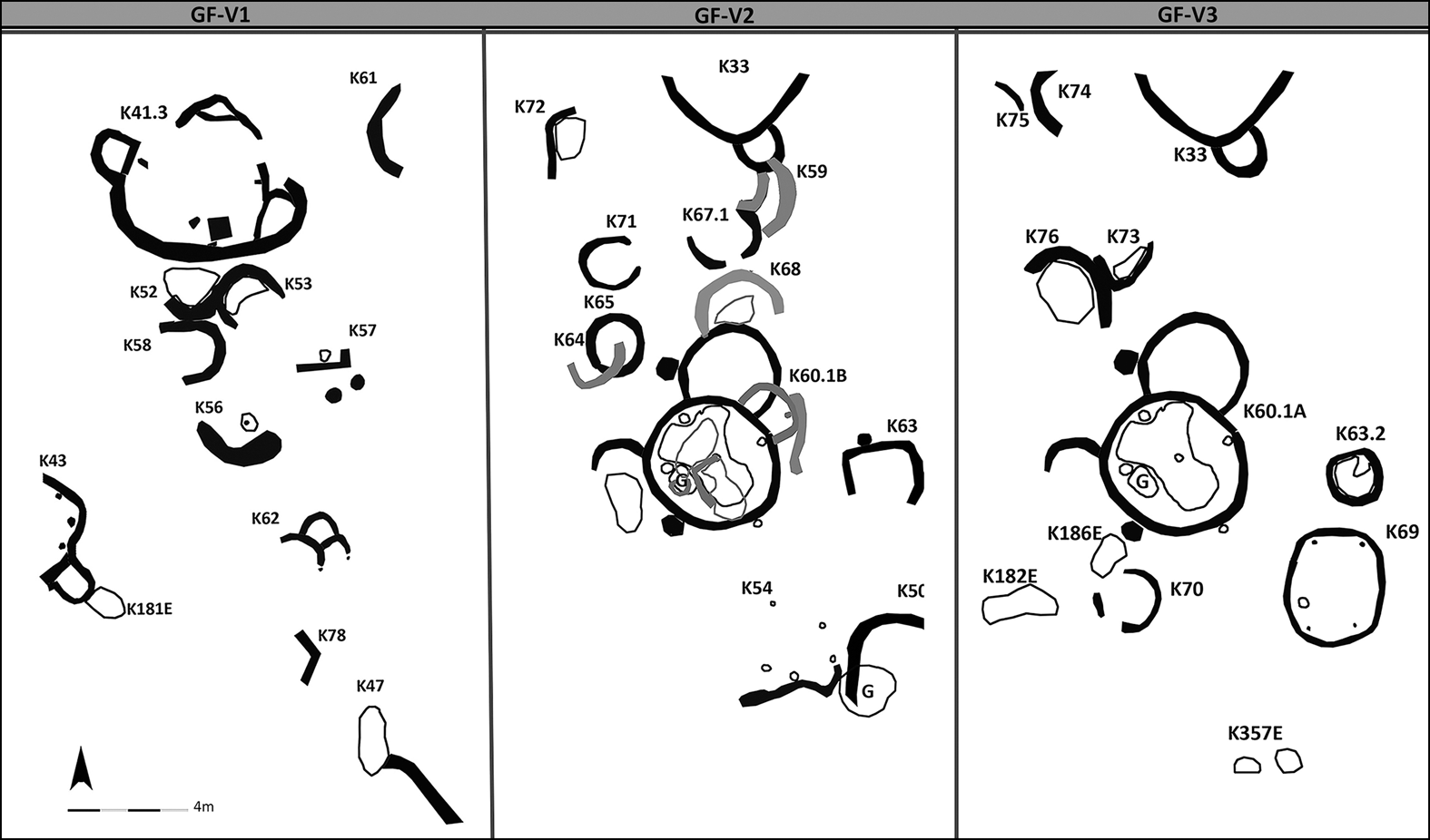
The architectural remains and other cultural materials recovered in the northern sector indicate the presence of a small village with three architectural levels during the PPNA (Figure 3). The early and middle PPNA levels (V2–3) feature independent circular pit structures alongside interconnected building complexes, reflecting a cohesive construction approach (Figure 3). Three distinct types of structures are apparent—round, quadrangular and C-planned—all with subterranean floors, plastered walls and burials beneath the floors (Figure 4). One of the pit structures (K60) forms a building complex, with two interconnected round units attached to the north and north-east of the main chamber, sharing walls. To the south of a C-planned attachment on the western side of the main chamber, the floors of several rounded storage features (silos) associated with the structure have been recovered. The C-planned units were used concurrently with independent round-planned pit shelters.
Architectural drawings of the Gre Fılla PPNA levels (drawn by author).

Samples of round, C-shaped and rectangular buildings from the PPNA, with some architectural details inside the buildings (figure by author).

The inner architectural features and associated assemblages indicate that these structures were mainly used as dwellings; however, the architecture of one structure (K41.3; Figure 5) indicates a different purpose. Two semi-circular units were attached to the main wall of the structure, each covering an area of 1m2. Unlike the subterranean floor of the main chamber, the stone-paved floors of these units were built above ground, and their interior walls are mud-plastered. Two stone stelae, each approximately 1m tall, were incorporated into the walls of the main chamber, and the earliest stone-built pillar in the settlement was found on its floor. Taken together, these architectural features and the size of the oval-shaped structure (16m2) may indicate a communal function, making K41.3 the only communal structure uncovered from GF-V.
Structure K41.3 where the earliest example of a stele and pillar are found, as is the impression of a mat on the floor in front of the perimeter wall (images from the excavation archive; figure by author).

The locations of open spaces, likely used for communal activities, seem to have stayed consistent throughout the PPNA, despite minor shifts in the surrounding structures. These areas contain fire pits, hearths and ash deposits with many animal bones.
A total of eight earthen burials have been uncovered beneath the floors and walls of some structures (K60, K57, K41.3). Individuals were laid in flexed and semi-flexed positions, oriented in east–west or north-west to south-east directions, mostly facing west. A range of grave goods, including beads, microliths, shells and animal bones, reflects the mortuary practices of the community. Two burials contain dog skeletons (Ekinbaş Can & Ökse Reference Ekinbaş Can and Ökse2024): one was laid headless on the fill of building K60 during its abandonment; the other was found among stone debris beneath the western wall of building K50, under two disarticulated human skeletons along with several horns and numerous animal bones. Similar burial practices have been identified at Demirköy (Rosenberg Reference Rosenberg, Özdoğan, Başgelen and Kuniholm2011b) and Çayönü (Erim-Özdoğan Reference Erim-Özdoğan, Özdoğan, Başgelen and Kuniholm2011).
PPNB (GF- IV)
GF-IV shows continuous habitation throughout the PPNB, spanning from the early ninth to the mid-eighth millennium BC. The architectural plans from this period include quadrangular cell-planned structures, large-chambered buildings, grill-planned structures, round pit-shelters and communal pit-structures that are either oval or quadrangular with rounded corners. The cell-planned buildings are of two types: those with and without buttresses. Large-chambered buildings are categorised as single- or multiroom structures, each further subdivided based on the use of buttresses.
Various types of floors are apparent, including compacted clay, lime-plaster and stone paving, and terrazzo floors have been preserved in one of the communal structures (K7.1A). Architectural elements such as benches, platforms and niches were exclusively used in communal structures (K15.1A, K8.4, G8.4). Both quadrangular buildings and pit structures include postholes, indicating that the roof was supported by wooden beams set in post slots fixed with stones or clay.
Thirteen architectural levels are recognised, organised into four stages (GF-IVA–IVD) based on structural features and settlement layout. The criteria for differentiating phased buildings from communal structures include the sizes of the dwellings, the architectural units associated with these buildings and the organisation of small finds.
The earliest stage (GF-IVD) underwent intense destruction; structural distribution analysis indicates that this stage constitutes only 17 per cent of all PPNB levels. As a result, changes in architectural features are not fully identifiable. The subsequent two stages (GF-IVC & GF-IVB), dating to the early and middle PPNB (8600–7600) (Figure 6), show technological diversity and changes in both dwellings and communal structures. During the latest stage (GF-IVA), corresponding to the late PPNB (7600–7400), the settlement appears to have reduced in size. Unfortunately, the architectural remains and cultural deposits from this stage were later disturbed by the Late Antique cemetery.
Architectural drawings of the IVB and IVC layers dated to the PPNB, with grill-planned buildings of the PPNB indicated below (figure by author).

A total of 11 earthen graves have been uncovered from beneath the floors of buildings K40, K41.1, K17.3, K32 and K23.6, all from GF-IVD. The individuals were positioned in flexed or semi-flexed poses, oriented in east–west or north-west to south-east directions, mostly facing west, showing continuity with the preceding PPNA burials. Grave goods were also similar, including a variety of beads, microliths, shells and animal bones. A baked clay miniature bowl found in an infant burial beneath the floor of structure K32 is unique to Gre Fılla (Ekinbaş Can Reference Ekinbaş Can and Engin2025a).
Development of architectural typology and technology
The architectural evidence from Gre Fılla presents a dynamic interplay between continuity and transformation from the PPNA to PPNB. This dynamism is observed in both domestic and communal structures.
Domestic architecture
During GF-V, domestic architecture is predominantly characterised by C-shaped and circular structures. While these structures are mostly seen as dwellings, structure K41.3 appears to have served a communal purpose (see above; Figure 5), a reinterpretation that becomes clearer through later rebuilding phases.
During GF-IV, 125 structures are documented, permitting a comprehensive typological classification across the PPNB levels (Table 2). This typology includes round pit-shelters and cell-planned, grill-planned and multi-roomed quadrangular buildings. GF-IVD consists of buildings with both rounded and quadrangular plans, indicating continuity from GF-V. Towards the end of GF-IVD, dwellings start to cluster around communal structures, reflecting a significant reorganisation in spatial planning and social structure.
The early and middle PPNB settlements (GF-IVC and IVB, respectively) show increasing diversity in domestic architecture. Grill-planned buildings feature a central open space surrounded by narrow chambers, such as K17.1, K17.2 and K20.2B. Notably, structure K20.2B includes asymmetrical side chambers, a stone-paved floor and possible posthole patterns, showing a typological similarity with the early PPNB structures at Çayönü (Erim-Özdoğan Reference Erim-Özdoğan, Özdoğan, Başgelen and Kuniholm2011) and Nevali Çori (Hauptmann Reference Hauptmann, Özdoğan, Başgelen and Kuniholm2011), although K20.2B appears somewhat later in the sequence at Gre Fılla.
Large rectangular structures with one or multiple chambers continue to be present throughout GF-IV. Changes across the 13 PPNB architectural levels are mainly seen in hearth construction and partitioning methods. The appearance of buttressed walls, with buttresses measuring between 0.2 × 0.3m and 0.5 × 0.9m, is significant. These walls were built with limestone and, in later phases, they were plastered with clay. In some buildings, buttresses are paired, appearing on opposite walls (e.g. structures K5, K14A, K13.1, K29) (Figure 7), while in others they appear on only one side (e.g. K11.3, K19.1, K16.1A, K20.1), suggesting functional or structural differences.
Dwelling buildings of the same type built in the same period (images from the excavation archive; figure by author).

Cell-planned dwellings are seen across all PPNB levels, evolving from simple planned structures in GF-IVD (K36.4) to more complex arrangements in GF-IVB and GF-IVA. Later buildings often feature rectangular or L-shaped central rooms surrounded by smaller mudbrick chambers, sometimes reinforced with internal buttresses. The use of clay plaster on walls and floors shows a growing investment in architectural finish and spatial use.
GF-IVB contains a grouping of identical quadrangular buildings—structures K5, K14.1 and K13.1. These were constructed using the same techniques along identical axes and share similar internal layouts. Their consistent artefact assemblages indicate co-ordinated construction, possibly reflecting standardised domestic or institutional uses within the settlement.
Communal architecture
The architectural record from Gre Fılla shows a consistent pattern of communal structures across the PPNB (GF-IV). Sixteen structures were identified in four separate locations—three in the northern area and one in the southern area (Figure 8)—built in a sequence with only minor variations. Each of these structures, within each location, represents successive renovations throughout the PPNB, and at least four communal buildings were in use at the same time. Although these structures were rebuilt in the same location with similar dimensions, slight axial shifts occurred during each reconstruction. Notably, structure G8.2 in the southern sector is significantly larger than its successor, G8.3.
Location of communal structures in the northern and southern excavation area (images from the excavation archive; figure by author).

In the early PPNB (GF-IVD), communal buildings feature curvilinear walls, as seen in structure K8.7, echoing the rounded pit-shelters of GF-V. However, from GF-IVC onward, these structures evolved into quadrangular plans with rounded corners, indicating both formal development and architectural standardisation. The consistent presence of four interior stone-built pillars in almost all communal structures (Figure 8), from the earliest levels to the latest, suggests a foundational element of communal architecture.
Yet, internal arrangements within these buildings differ, especially in structures K7.1 and K7.2, which deviate from the typical single-chamber design by including internal chambers. These chambers are symmetrically arranged around the four pillars, forming a quadrangular central space. Over time, these internal sections became more complex, increasing the number of cells and adding architectural features such as terrazzo or clay floors, niches, stelae and passageways. In structure K7.2, a small cell shows signs of functional adaptation, with a window or passage that was intentionally blocked using a flat limestone slab. Comparing communal structures with interior subdivisions reveals a sophisticated understanding of the community’s spatial organisation and social functions, highlighting cultural and architectural development during the PPNB period.
Discussion
The material recovered from Gre Fılla indicates that a small community occupied the site for an extended period. Chronological analysis of the sediments and carbon samples provides strong evidence that Gre Fılla was a permanent settlement.
During the PPNB, round-planned dwellings gradually transformed into quadrangular plans with rounded corners, eventually becoming sharp-cornered structures. The variety of plan types shows continuity between architectural levels with some modifications. The wattle-and-daub technique, seen in building K45 in the early PPNB level GF-IVD2, was not used in any levels of GF-IVC, but reappears in the buttressed, cell-planned building K20.1 in the middle PPNB level GF-IVB2 (Figure 9). Based on the presence of postholes, most communal structures and some dwellings had roofs supported by wooden beams, providing an element of architectural continuity across all periods of GF-V and GF-IV. While the communal structures were likely accessed through the roof, the dwellings had doors with jambs and thresholds.
Buildings constructed in the wattle-and-daub technique, which continued through the Early and Middle PPNB phases (images from the excavation archive; figure by author).

While dwellings at sites across the Upper Tigris Basin, the Middle Euphrates Basin and in contemporaneous Levantine settlements share notable similarities, clear regional distinctions are apparent. Cell-planned dwellings in the Upper Tigris Basin show variability: those at Çayönü (Erim-Özdoğan Reference Erim-Özdoğan, Özdoğan, Başgelen and Kuniholm2011) and Boncuklu Tarla (Kodaş & Çiftçi Reference Kodaş and Çiftçi2021) are similar in cell number and layout, whereas Gre Fılla structures differ in room count and features such as wall buttresses. Large-roomed rectangular structures are only seen in the late PPNB phase at Çayönü, while at Gre Fılla this building type was used earlier and became the dominant type (Table 2). Within the Upper Tigris Basin, the architecture at Gre Fılla aligns most closely with Boncuklu Tarla, especially regarding grill-planned buildings and pillars in communal structures. Although the iconography in these communal buildings diverges from the Upper Tigris tradition, certain motifs—human faces on altars, wild boar sculptures and human figurines—show similarities with sites in the Middle Euphrates Basin, including Nevali Çori (Hauptmann Reference Hauptmann, Özdoğan, Başgelen and Kuniholm2011), Göbekli Tepe (Schmidt Reference Schmidt, Özdoğan, Başgelen and Kuniholm2011) and Karahan Tepe (Karul et al. Reference Karul, Semiz, Polat and Özme2023). These patterns suggest that Gre Fılla reflects both local architectural innovation and selective incorporation of broader regional symbolic practices.
The settlement pattern at Gre Fılla, with rectangular domestic structures arranged around central communal buildings, is similar to the layouts seen at Gusir Höyük, in the Upper Tigris region (Karul Reference Karul, Özdoğan, Başgelen and Kuniholm2011) and Jerf el Ahmar (Stordeur Reference Stordeur2015), in the Middle Euphrates Basin, indicating possible commonalities in settlement organisation during the early Neolithic periods. In contrast, communal buildings at Nevali Çori and Çayönü were located away from domestic structures, while the spatial relationship at Boncuklu Tarla is unclear, as the excavations have not yet been completed. At Gre Fılla, this arrangement of domestic buildings around communal structures—initiated in the Early PPNB—was maintained and repeatedly renewed into the late PPNB, showing a sustained and evolving architectural approach.
Fire pits in the open areas between structures suggest a communal practice of open-air fire-related activities during the PPNA (GF-V), similar to Hallan Çemi (Rosenberg Reference Rosenberg, Özdoğan, Başgelen and Kuniholm2011a), Çayönü (Erim-Özdoğan Reference Erim-Özdoğan, Özdoğan, Başgelen and Kuniholm2011) and Abu Hureyra (Moore et al. Reference Moore, Hillman and Legge2000). The rough alignment of streets in level GF-IVD1 became more organised in GF-IVC and GF-IVB, with the construction of communal structures and dwellings on top of similar previous structures indicating a planned settlement layout. The street surfaces were either made of compacted clay or were mud-plastered or paved with pebble stones. Hearths, rather than fire pits, were built next to the outer walls of houses in the PPNB (GF-IV). Although few hearths appear on the streets during GF-IVD, they were used extensively during GF-IVC and GF-IVB. Animal bones found in deposits on streets with hearths demonstrate active daily use. The creation of dead-end streets by linking the exterior walls of some dwellings (K17.1B–K23.1) reflects complex and evolving social relations.
Continuity in architecture at Gre Fılla is apparent not only in plan types but also in various related practices, such as the ‘cleaning’ and ‘burying’ of buildings, defined as ritual behaviours (Özdoğan & Özdoğan Reference Özdoğan, Özdoğan, Arsebük, Mellink and Schirmer1998; Karul Reference Karul2021) and documented during both GF-V and GF-IV. These practices involved the removal of all detritus from inside the buildings, the floors were then swept and the chambers purified with fire. Some dwellings and all the communal structures were filled with spoils following this cleaning, including the bones of sacrificed animals and various small finds, indicating that ritualised behaviour formed part of this sealing of the previous level before the construction of a new building began. A child’s skeleton, probably a secondary burial, was incorporated into the masonry of the wall of structure K.41.3 in GF-V before the floor of this structure was filled with sieved sterile soil. Practices were also observed during the initial construction phases of some dwellings, such as the deposition of animal bones and ground stone artefacts beneath the eastern walls of buildings K1.5 and K12, and the inclusion of a cattle horn embedded in the stone-paved floor of building K12.
The tradition of cleaning and burying/sealing communal structures is observed at Çayönü (Erim-Özdoğan Reference Erim-Özdoğan, Özdoğan, Başgelen and Kuniholm2011), Hallan Çemi (Rosenberg Reference Rosenberg, Özdoğan, Başgelen and Kuniholm2011a) and Boncuklu Tarla (Kodaş & Çiftçi Reference Kodaş and Çiftçi2021) in the Upper Tigris region, and at Göbekli Tepe (Notroff et al. Reference Notroff, Dietrich, Schmidt and Osborne2014), Karahan Tepe (Karul Reference Karul2021), Nevali Çori (Hauptmann Reference Hauptmann and Frangipane1993: 55), Sefer Tepe (Güldoğan & Uludağ Reference Güldoğan and Uludağ2022), Jerf el Ahmar (Stordeur Reference Stordeur and Guilaine2000), Dja’de El Mughara (Coqueugniot Reference Coqueugniot2011) and Tell Abr 3 (Yartah Reference Yartah2013) in the Middle Euphrates region. The practice of filling entire structures or specific parts of structures with sieved sterile soil is also documented at Çayönü (Erim-Özdoğan Reference Erim-Özdoğan, Özdoğan, Başgelen and Kuniholm2011), Çatalhöyük (Hodder Reference Hodder2006, Reference Hodder and Hodder2010), Beida structure T1 and T2 (Kirkbride Reference Kirkbride1968) and Ain Gazal (Rollefson Reference Rollefson2005) (Figure 10).
Parallels of the communal buildings at Gre Fılla: 1–2) recorded at (3) Gusir Höyük (Karul Reference Karul2020); 4) Boncuklu Tarla (Kodaş & Çiftçi Reference Kodaş and Çiftçi2021); 5) Jerf el Ahmar (Stordeur Reference Stordeur2015: fig. 23); 6) Tell Mureybet (Stordeur & Ibáñez Reference Stordeur, Ibáñez and Ibáñez2008: photo 3); 7) Tell Abr 3 (Yartah Reference Yartah2013: fig. 101/2); 8) Göbekli Tepe (Schmidt Reference Schmidt, Özdoğan, Başgelen and Kuniholm2011: fig. 26); 9) Karahan Tepe (Karul et al. Reference Karul, Semiz, Polat and Özme2023: fig. 5); 10) Nevali Çori (Hauptman Reference Hauptmann, Özdoğan, Başgelen and Kuniholm2011: fig. 8). See Figure 1 for locations (figure by author).

The use of buttresses in walls is a common architectural feature in the domestic buildings of Gre Fılla. Despite some variations in material and size, the technique shows continuity throughout the levels of GF-IV. Similar buttresses have been found elsewhere in the Upper Tigris region, especially in communal structures at Çayönü (Erim-Özdoğan Reference Erim-Özdoğan, Özdoğan, Başgelen and Kuniholm2011) and Boncuklu Tarla (Kodaş & Çiftçi Reference Kodaş and Çiftçi2021), as well as in the Middle Euphrates region, in the ‘Cult Building’ at Harbetsuvan Tepesi (Çelik Reference Çelik2020), in the circular or round-cornered rectangular structures at Sayburç (Özdoğan & Uludağ Reference Özdoğan, Uludağ and Keskin2024) and in the quadrangular structures at Sefer Tepe (Güldoğan & Uludağ Reference Güldoğan and Uludağ2022). In the Levant, similar practices are observed at Beida (Byrd Reference Byrd2005).
Interior architectural organisations also show continuity. The altars in some of the rebuilt communal structures were placed in the same locations (Ekinbaş Can Reference Ekinbaş Can2025b). The altar in K8.4 was a complex table made of a flat stone combined with a stone bowl built on top of the simple platform altar of K8.6. The early PPNB inhabitants of GF-IVD and GF-IVC used simple altars, while the middle PPNB inhabitants of GF-IVC and GF-IVB created more complex ones. During the middle PPNB, levels GF-IVC and GF-IVB exhibit a dense architectural settlement pattern with a variety of households that include indoor storage, diverse construction techniques and specialisation in industry. This settlement pattern and the developing architectural arrangements reflect the collective life of a more socially complex and economically diverse community (Ökse Reference Ökse, Sisa-López de Pablo, Bach-Gómez and Molist2024; Ekinbaş Can Reference Ekinbaş Can2025c).
Conclusion
The typological and technical diversity of the buildings at Gre Fılla provide evidence for a high degree of social and technological development in the northernmost part of the Upper Tigris region during the PPNB. Storage areas became a part of daily life, both in open spaces in the PPNA (GF-V) and inside dwellings in the PPNB (GF-IV). Although all building types were documented throughout GF-IV, grill-planned buildings were used only in the middle PPNB (GF-IVB and GF-IVC), with changes in building techniques and innovations, such as the use of buttresses and different types of hearths and floor coatings, being especially prominent in this period. Both communal structures and dwellings repeatedly occupied the same spaces, with successive iterations built on top of each other and demonstrating only minor shifts in their axes, indicating continuity. The architectural concepts of GF-V (PPNA) are observed at several contemporaneous sites in the Upper Tigris region but the limited number of PPNB settlements in the area restricts our ability to determine the full geographic distribution of all architectural elements observed at Gre Fılla. The settlement at Gre Fılla includes more than 100 structures spanning from the PPNA to the end of the PPNB, and exemplifies the features of PPNB architecture in the Upper Tigris region. Gre Fılla also offers valuable insights into the socio-cultural patterns of the region. The relationship between dwellings and communal structures demonstrates the transformation of social organisation during the periods in which the site was occupied, and shared elements of architecture suggest a substantial network of connections with neighbouring regions.
Funding statement
This research received no specific grant from any funding agency or from commercial and not-for-profit sectors.
Online supplementary material (OSM)
To view supplementary material for this article, please visit https://doi.org/10.15184/aqy.2026.10282 and select the supplementary materials tab.