

INTRODUCTION
In England, the period of the mid-seventh to mid-ninth centuries has proved the least well understood and most frequently neglected in early medieval archaeology. Materially it is less visible than the period immediately preceding, but it also possesses fewer written sources than that which follows. The seventh century is a time characterised by the adoption of unfurnished burial, and the apparent abandonment of monumental hall complexes by their elite occupiers. Even on lower-status settlements, Grubenhäuser (pit-houses) were rarely constructed after the eighth century, eliminating for archaeologists a key feature detectable through aerial photos and artefact scatters in the ploughsoil. Understanding of this hitherto obscure period, however, has been transformed over recent decades by an unlikely ally: the hobbyist metal detectorist. Increasing numbers of detectorists now conduct their work in a responsible manner, and from 1997 have been able to report their finds to the Portable Antiquities Scheme (PAS) for the benefit of the public and researchers.Footnote 1 In Eastern England especially, this work has resulted in a vast new dataset from the seventh and ninth centuries, and new terminology to describe these concentrations of material.Footnote 2
The story of the scientific investigation of a site in the parish of Little Carlton in Lincolnshire has much in common with other, well-recognised sites of the period, such as such as Brandon in Suffolk and Flixborough in Lincolnshire.Footnote 3 The research team quickly realised that activity was spread across a wide area; however, attempts to establish the character and overall development of the site stand on less secure ground. This is partly a product of finite resources; from the outset, it was acknowledged that even an extensive and lengthy research programme would characterise only a sample of a complex archaeological landscape. Over the gestation of the project, concerns around the existing frameworks of early medieval elite centres also began to be recognised, issues that would have impinged interpretation even of a fully-excavated site. Scholarship in the subject area continues to be inhibited by cumbersome terminology and understanding primarily framed by document-derived agendas and narratives. This is not to suggest that written sources should be ignored or disregarded; the early medieval period is undoubtedly one that is enriched through interdisciplinary approaches, and the present analyses of Little Carlton certainly draw on a range of academic endeavour. Likewise, this work does not seek to undermine the efforts of individuals who have led the direction of scholarship to date, and whose thought has often profoundly shaped how Little Carlton is understood.
Greater effort is needed, nevertheless, to place archaeology at the forefront of academic understanding, especially when interpreting sites such as Little Carlton for which no early medieval documentary evidence exists. Indeed, the floruit of occupation at Little Carlton, which is dated to between the seventh and ninth centuries, is a period that should be approached principally through material remains; the nature of archaeology ensures that new data is always being produced in a manner unmatched by any other discipline. As the corpus of material increases so does the need for more appropriate frameworks, and not those stemming from an understanding of the written record. Therefore, in addition to providing a detailed overview of the findings from Little Carlton, this paper attempts to develop a new, archaeologically-orientated research agenda for early medieval sites found through metal detecting. It will be argued that the distinction between ‘secular’ and ‘ecclesiastical’ has been drawn too sharply, and that labelling sites as ‘minsters’, ‘monasteries’ or ‘secular estates’ otherwise adds little to how these communities and their activities are appreciated. Similarly, while elaborate metalwork has long been the beneficiary of acute scholarly attention, celebrated as exotic proof of an exciting new environment of international trade and wealth from the seventh century, archaeology amplifies equally the importance of longer-term, more ephemeral and undocumented indigenous practices integral to the daily lives of those living at Little Carlton.
A key component of formulating a distinctive, archaeologically-orientated research agenda is the deployment of suitable and meaningful terminology. Little Carlton, and other sites across eastern England that have yielded impressive early medieval metalwork assemblages, have in the past been coined ‘productive sites’.Footnote 4 From its earliest usage, though, the term has been recognised as problematic. Not only have the histories of retrieval of ‘productive sites’ given them distorted prominence, the catch-all term also renders homogenous what is in all likelihood a variety of site-types, just ones that have the shared trait of yielding metalwork.Footnote 5 This latter issue is compounded by the limited archaeological exploration dedicated to the majority of sites, hampering the potential for comprehensive analysis. Indeed, even in cases where recovery of metal-detected assemblages has been followed by archaeological intervention, the extent to which activity can be accurately categorised remains highly contested.Footnote 6
The term ‘productive’ also has the unfortunate added potential to be entirely misconstrued, especially by non-specialists. Alluding to the great returns offered to metal detectorists, the expression is easily misread as denoting a place of past industry or production rather than one derived from present-day recovery patterns. Excavation has demonstrated centres of manufacture in some instances, including at Little Carlton, but activity across different sites almost certainly varied, and many metalworking foci are better interpreted as temporary locations with an emphasis on exchange rather than production. It is clear, then, that the ‘productive site’ has little to commend it and that alternative terminology is required. ‘Metal rich’ and ‘metal detected’ will be used interchangeably here, both representing preferable alternatives that at least indicate something of the artefact signature of a site or its method of identification by archaeologists.
THE DISCOVERY OF LITTLE CARLTON
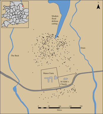
In 2011 metal detectorist Graham Vickers started to work in fields in the eastern portion of the parish of Little Carlton. It is highly likely that earlier unrecorded metal detecting had previously taken place at the site. There is anecdotal evidence that two elaborate gold finger rings, dating to the ninth and tenth centuries, along with a silver gilt filigree pin head came from Little Carlton.Footnote 7 All of these items were sold at auction, however, and none of them can be attributed to the site with any confidence.Footnote 8 Fortunately, Graham’s subsequent work was far more systematic, and as he detected he diligently recorded the find spot of each item with a hand-held global positioning system device. He also retained not only precious metals and copper alloy, but also lead and ironwork, as well as collecting surface finds of ceramic and glass, resulting in an extremely comprehensive collection of archaeological material. The finds are distributed over a distinct elliptical area measuring approximately 250m × 350m, surrounding the redundant parish church of St Edith (fig 1). Although this assemblage includes a small quantity of Roman, later medieval and early modern material, the vast majority dates to between the seventh and ninth centuries ad. It was only when Graham started to register his finds with Adam Daubney at the PAS in Lincolnshire, however, that the true scale and importance of his efforts became clear.
Location of the site and distribution of metal-detected finds. Drawing: authors.

Before this metal detecting, the only indication of pre-Conquest activity at Little Carlton was identified during the demolition of St Edith’s Church in 1993,Footnote 9 when a fragment of limestone grave cover was found within the rubble fill of the later medieval nave wall. Decorated with a figure-of-eight pattern and dating to the tenth or early eleventh century, the piece first raised the probability that an earlier medieval church once occupied the site or was located somewhere else in the immediate vicinity.Footnote 10 Despite this identification, a number of subsequent watching briefs adjacent to the church failed to locate any further evidence for early medieval activity.Footnote 11 This history of research serves to emphasise the limited efficacy of certain archaeological evaluative techniques for locating the often ephemeral material signatures of the earliest medieval centuries, but also stresses the value of systematic and responsible metal detecting. To date, more than 800 non-ferrous small finds from Little Carlton have been recorded by the PAS, although this number represents a fraction of the overall finds assemblage. Unrecorded by the PAS, for instance, is more than 6kg of worked lead objects, 30kg of lead melt and waste and 26kg of pre-Conquest pottery, all of which was collected by the detectorist. Even though much of the early medieval assemblage is hard to date precisely, coins and those artefacts that are more chronologically distinctive suggest an intensity of activity between the mid-seventh and mid-ninth centuries ad. The assemblage from Little Carlton, therefore, represents the largest concentrated surface collection of finds of this date from Lincolnshire and is also one of the most important and best-recorded assemblages of the entire early medieval period from anywhere in England.
TOPOGRAPHIC SETTING
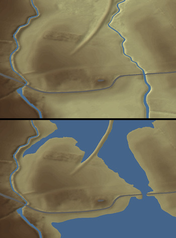
Little Carlton is situated approximately 7.5km to the east of Louth, on a band of glacial till that forms the edge of the Lincolnshire Wolds. Lying on the 5m contour, the site is located at the point where two streams, the Beck and the Long Eau, empty into the tidal flats of the Lindsey Marsh, at what would have been the interface between the coastal wetlands and the habitable shore in the seventh century. The concentration of metal-detected finds at Little Carlton closely corresponds with the topography of the site; LiDAR and UAV data shows the artefact scatter restricted to an area of slightly raised land between two watercourses, and although the surrounding area is now under cultivation, this has only been the case for the last few decades (fig 2). Maps dating to the nineteenth century record field names to the south of the site as ‘Little Fen’ and ‘Horse Fen’, while to the north is ‘Engine Fen’, all of which allude to low-lying marshy areas unsuited to permanent settlement.
Topography of the site today, and with levels raised. Drawing: authors.

In contrast, the field from which the majority of the metal-detected finds originates was once known as ‘The Bruff’, possibly a mutation of the Old English burh suggesting the presence of an enclosed and more enduring habitation.Footnote 12 Until the natural development of a protective storm beach during the eleventh century, the landscape of the site would have experienced tidal inundation and elevated water levels compared with those today.Footnote 13 Indeed, when reconstructing the former topography, it is notable that a rise of just 1m above present water heights results in almost the entire site being surrounded, creating either an island or an isthmus connected by a narrow causeway (fig 2). Little Carlton in the seventh century thus sat at a nodal point, on the edge of the Lincolnshire Wolds but directly connected to the North Sea. Although this setting offered a range of valuable natural resources, arguably it was the accessibility to networks of transport and trade that impacted most on the development of the site throughout the medieval period.
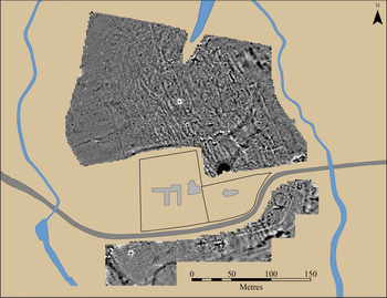
The first stage of fieldwork comprised a magnetometer survey, which revealed surviving subsurface anomalies restricted to the area of the island and closely mirrors the distribution of metal-detected finds (fig 3). The most substantial of these anomalies was curvilinear and visible on the eastern, southern and western sides of the island. Interpreted as a boundary ditch, the purpose of this feature was subsequently demonstrated through excavation. The ditch was truncated to the north-east by modern land drainage works and, although it is not detectable in the north-west, this is probably the result of heavy truncation by modern ploughing. Within the enclosed area the geophysical survey showed a series of rectilinear anomalies, with a particular concentration to the north of St Edith’s Church. In the southern part of the site, to the south of the modern road, further anomalies were also discernible. One of these was an area of high magnetic variation immediately outside the boundary ditch, potentially related to some form of high-temperature activity. In the south-western area an anomaly that appeared to represent a ring-ditch corresponded with a gap in the line of the enclosure.
Magnetometer survey. Drawing: authors.

EXCAVATIONS
Evaluation trenches
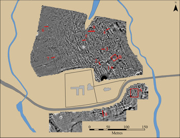
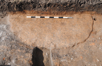
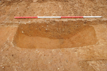
The results from the geophysical survey informed an initial excavation strategy comprising nine evaluation trenches, located with the aim of characterising archaeological deposits and their state of preservation (fig 4). Eight of the trenches were situated to the north of St Edith’s Church, five targeted linear anomalies (Trenches 1–4 and 7), and two were positioned over ‘blank spaces’ with no detected anomalies (Trenches 5–6) to act as control samples. Trenches 2 and 3 were located over a strong right-angled anomaly, identified as a later medieval field boundary. Trench 2, however, also demonstrated that the boundary was cutting a gravel surface, orientated east–west, and from which was recovered early medieval ceramics and a single Series QIG sceat (c ad 725–45). The majority of features identified in other trenches consisted of shallow ditches or gullies, possibly representing fence lines, and forming a series of discrete enclosures (fig 5).
Trench and area locations. Drawing: authors.

Trench 5 gully. Photograph: authors.

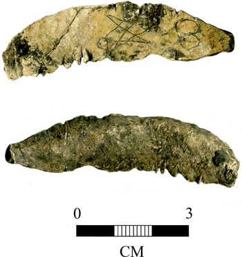
Trench 8 was situated to the south of the road, targeting the presumed boundary ditch and adjacent high magnetic anomalies. Excavation identified a ditch, measuring 2m wide and 1.5m deep, revetted on its south-facing inner slope with a series of partially surviving wooden posts. One of the supporting posts was radiocarbon dated to ad 656–769, at 95.4 per cent probability (Beta Lab-504572). To the south of the boundary ditch was a band of relatively compact dry land that seems to have been the focus for an intensive phase of industrial activity, before dropping off in height sharply to the south at what was the seventh-century shoreline. This was evidenced by the formation of a thick layer of dark water-lain peat, which contained a high concentration of butchered animal bone and ceramics, primarily local Maxey Wares. Here, as elsewhere on the site, the animal bone assemblage was dominated by young pigs and mature cattle, with smaller numbers of other domesticates and wild animals. This is suggestive of extensive meat consumption and likely feasting taking place, similar to the pattern observed during the seventh- and eighth-century phases at Flixborough.Footnote 14 A line of parallel posts was visible running west–east on the edge of the former water’s edge, suggesting that a small boardwalk or wharf was present at this point. In the area between the water’s edge and the boundary ditch, the evaluation trench revealed a circular hearth base 1.8m in diameter (fig 6). Although heavily truncated by ploughing, this feature was associated with a significant quantity of lead working waste and slag. Also found close by the hearth was a small lead object 62mm in length (fig 7). This had a rough triangular underside formed through being cast into an irregular hollow, although the upper surface was flat and intentionally inscribed with a lattice character similar to, but not precisely the same as, a runic ‘ng’ and a figure-of-eight symbol. The object has been intentionally notched on either side with sharp knife cuts, and appears to have been used as a measure or tally. Two very similar objects were found at the contemporary site of Flixborough, Lincolnshire, one with a similar lattice design, where they too were interpreted as tallies.Footnote 15
Trench 8 hearth. Photograph: authors.

Trench 8 tally. Photograph: authors.

The final evaluation, Trench 9, measuring 20m × 1.5m, was located in the northernmost area of the site, just within the boundary ditch as visible on the geophysics. This excavation was positioned in an area where parts of human bone were visible in the topsoil, and it was anticipated that a cemetery might have existed in this location. Upon removal of the ploughsoil, however, it was clear that there were no burials within the confines of the trench. It was concluded that the skeletal material must have derived from a cemetery close by that had been dragged by the plough, a process that had also removed virtually all stratified deposits in the area. Despite this, there were clear indications of industrial activity, with a portion of surviving natural soil being highly burnt, presumably by a furnace or hearth located above. The hearth was associated with a shallow, curved and steep-sided ditch, which enclosed the feature. It is uncertain whether this was as a way of controlling groundwater, or if the feature had a more symbolic function, delineating the activity within the settlement space. Once the furnace had gone out of use, it appears to have been deliberately dismantled, and elements of its superstructure, as well as a quantity of slag, were recovered from the fill of the surrounding ditch.
Open area excavation
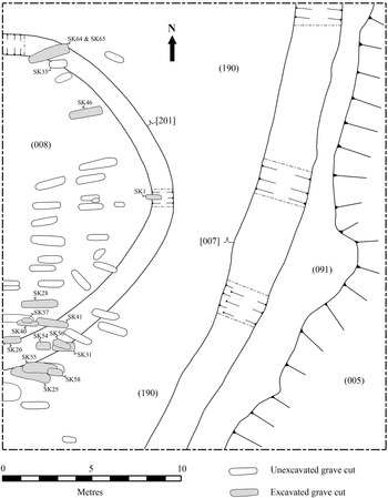
Following the results of the evaluation trenches, two open area excavations were undertaken to characterise further the most complex zones of archaeological activity. Area A, measuring 21m × 25m, was located in the south-eastern corner of the enclosure and targeted two anomalies detected by the geophysical survey: the ‘gap’ in the enclosure ditch, perhaps representing an entrance, and a circular feature, initially interpreted as a ring-ditch (fig 8). On removal of the plough soil it became immediately apparent that there was, in fact, no break in the enclosure at this point, and, rather, the misleading geophysical effect was probably caused by ditch fills with slightly varying magnetic properties. The boundary ditch [007] was found to be of the same proportions encountered in the excavations in Trench 8 to the west, being around 2m wide and 1.4m deep, with evidence for at least one phase of re-cutting and an internal bank that, given the lack of material culture present, had been deliberately backfilled into the ditch once the site had gone out of use (fig 9). External to the boundary ditch to the east was a berm of land (091), between 2m and 4m wide before the original land surface dipped away, and deposits of water-lain peat were encountered (005). When sampled, this deposit contained significant quantities of small finds, although significantly a much lower density of animal bone than Trench 8 on the southern edge of the island. This differential pattern suggests that dumping of waste into the water’s edge was zoned across the site, and this area at least experienced little or no disposal of food waste.
Area A plan. Drawing: authors.

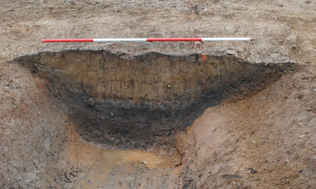
Section through early medieval boundary ditch. Photograph: authors.

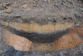
The circular feature [201] seen on the geophysical survey was more ephemeral on excavation but proved to be 1.5m–1.6m in width and 0.5m–0.6m in depth, with a shallow-sloped inner edge (fig 10). No datable material was found in any sections dug across the ditch, and it appears to have silted up quickly with a sandy deposit. Although the enclosed space of the feature had clearly been flattened by recent agricultural activity, it consisted of a much lighter, sandier, soil than the surrounding area, and can confidently be interpreted as the ploughed-out remains of a burial mound. Unfortunately, no material culture was recovered that can positively date the construction of the monument, although significantly this zone contained a far higher density of flint flakes and debitage than encountered anywhere else on the site, suggesting a Bronze Age origin.Footnote 16
Section through Bronze Age barrow ditch. Photograph: authors.

Inserted into the enclosed area of the former mound and its ditch were a large number of inter-cutting inhumations. Due to their shallow depth, the upper portions of the burials had been severely truncated by modern ploughing, while those at a lower depth had been in some cases repeatedly bisected at approximately 1m intervals by agricultural dragged-mole drainage. As a result, the inhumations were in a highly fragmented and degraded state, and many only survived as disarticulated remains. Despite these conditions, fifty-eight individual grave cuts were discernible across the excavation area, probably representing only a small proportion of those originally present. Twenty-three of the burials were selected for excavation, and the remaining thirty-four left in situ. Analysis has shown that this was a mixed population with males, females, adults and juveniles all represented (see Appendix SM1).
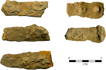
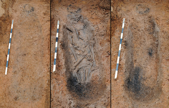
All of the burials were aligned on a west–east axis, and from the position of the skeletons and the shape of the grave cuts, many were presumed to originally to have been coffined, a fact confirmed by the occasional survival of small elements of iron strapping. These fittings were frequently found unstratified, though, having been scattered from their original burial positions by later agricultural activity (fig 11). The use of wooden coffins on the site was evidenced more compellingly by a single burial to the north of the trench. Directly underlying a slightly later burial, SK64, this earlier grave was slightly deeper than the silted-up ditch of the burial mound through which it had been cut, and as a result was more waterlogged. Here an elongated wood stain with slightly curving sides and elliptical ends could clearly be discerned, indicative of a hollowed log, rather than a planked, coffin (fig 12). To the immediate west, at the head end of the burial, the base of a circular post 0.18m in diameter also survived as a stain indicating that, in this case at least, an organic marker had been used to indicate the presence of the grave. On excavation, the burial proved to contain the remains of an adult (SK65) one of whose teeth provided a calibrated radiocarbon date of ad 660–770, at 95 per cent probability (Beta Lab-442776). The suggestion that many of the dead were buried in coffins is significant and bears a resemblance to the recently-excavated cemetery at Great Ryburgh, Norfolk, where eighty-nine interments in loosely organised rows were placed in hollowed logs, with a further six in planked coffins.Footnote 17 Dating to the eighth century, it has been suggested that the Great Ryburgh burials represent part of an early Christian community, and were found in association with a small timber building interpreted as a church.
Iron coffin fittings from Area A. Photograph: authors.

Burial of SK65. Photograph: authors.

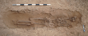
Sixteen burials were sufficiently undisturbed to be studied osteologically (Appendix SM1). Of these, fifteen appeared to have been buried supine, and one flexed and slightly on their right side (SK54). One of the supine burials, SK46, proved to be particularly revealing about both the burial rite and the possible later disturbance of the skeleton (fig 13). A female aged 24–40 years, unlike most of the other inhumations, had clearly been tightly bound before burial, the distance between the left and right scapula being around 0.15m, and there was no evidence from the grave cut or iron fittings for the presence of a coffin. Although the tightly bound torso had been placed supine, the head was detached and lay face down about 0.10m from the neck. The arrangement of the legs was also unusual; the femora had detached and rotated so that the femoral heads pointed laterally, away from the pelvis. The lower legs also appear to have been tightly bound and in the correct supine position, but disjointed from the femora and a little distance to the north. The reason for the movement of the femora is unknown; in coffined burials where there was room for movement, this might be explained as a natural post mortem phenomenon. The clear evidence for the very tight binding of the body makes this unlikely, however, and the degree of disarticulation of the lower limbs and head suggests that the individual had either died elsewhere and only subsequently been interred in this location sometime later, or their body had been subject to interference many months if not years after it was first interred.
Burial of SK46. Photograph: authors.

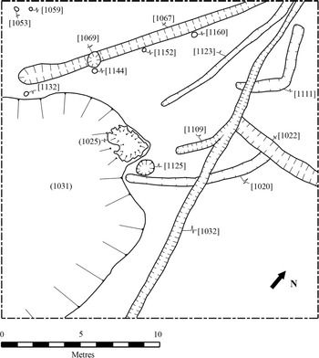
A second open area excavation, Area B, measuring 20m × 20m was located in the field to the north of the church (fig 14). The target of this trench was geophysical anomalies suggestive of several enclosures, and it was anticipated that evidence for domestic occupation would be identified. Following the removal of the ploughsoil and a thick layer of water-lain clay that capped most of the exposed area and sealed the early medieval deposits, a sizeable subcircular feature approximately 15m in diameter could be seen in the south-western corner of the trench. Around half of this feature lay within the confines of the trench, and it contained a black organic-rich sediment (1031). Upon excavation, it was clear that this feature was in fact a shallow-sided pond, or pool, fed by the underlying water table. Indeed, despite extensive land drainage having taken place in the field for over a century, on the removal of the pond sediments during excavation it continued to fill with groundwater. It appears that this feature was naturally occurring and predated the settlement of the site; the primary fill (1107) of the pool, which was up to 0.25m deep towards the centre, was utterly devoid of any material culture and consisted only of fine water-lain silts and some small wooden twigs preserved as lighter coloured stains.
Area B plan. Drawing: authors.

Overlying this initial silting was a deeper homogeneous deposit (1031), up to 0.45–0.50m thick in places and almost black in colour due to the high concentration of charcoal. This context also contained a very considerable quantity of cultural material: animal bone, ceramics including local Maxey-type Wares, Ipswich Wares and Badorf Ware, and several fragments of vessel glass (see Appendix SM3 for a summary of excavated and field walked ceramics). On the basis of this remarkable finds profile, it appears that the pond was used as a feature for dumping domestic waste from elsewhere on the site. In this aspect, it fulfilled a similar function to other naturally-occurring features found at contemporary early medieval centres, such as the shallow valley at Flixborough, and the solution hollow at Lyminge in Kent, both of which contained the majority of finds recovered from each site.Footnote 18
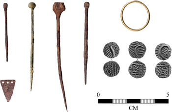
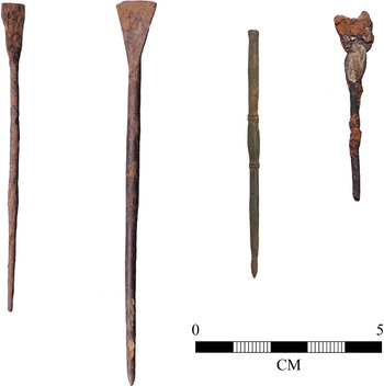
The pool yielded a significant number of more valuable finds, too, the concentration of which within a limited area is hard to explain in terms of accidental loss. Items of recovered jewellery included two copper-alloy hooked tags, four copper pins (all of which were complete) and, most remarkably, a solid gold finger ring (fig 15). This last find is particularly unusual as, although similar copper-alloy rings have been found at Brandon in Suffolk, Cottam in East Yorkshire and York, the recovery of a gold example from a sealed early medieval settlement context is unique.Footnote 19 Other finds from within the pool include three Series E primary sceattas, c ad 690–710, found clustered within a metre of each other, and four styli (fig 16). Although clearly worn when deposited, three of the styli were complete and unbent, and included a unique type without a flattened spatula end. The presence of a fourth stylus is probably indicated by the find of a poorly preserved silver foil mount still adhering to some copper backing that closely resembles those found on the Class vi styli from Flixborough.Footnote 20
Finds of dress accessories and coins from the pool. Photograph: authors.

Finds of styli from the pool. Photograph: authors.

While it is conceivable that some of the smaller items, such as the hooked tags, may have been deposited inadvertently and unnoticed among other domestic waste, this is less likely to be the case with the larger items. In particular, the styli were high-status objects and still perfectly serviceable, and the concentration of such a significant number within a couple of metres of each other, and contained within this specific feature, cannot be a coincidence; no others were found in any other excavated area of the site. Likewise, the gold ring would have been a highly valuable object and, found near the centre of the pool, it is unlikely that such a weighty item was accidentally dropped and carried so far into the deeper water. Instead a scenario might be presented where some form of intentional depositional practice was taking place at the pool which included the placement of precious objects. Artefacts such as the styli, given their use in the production of text, are likely to have been seen as sacred; their deposition in the pool may have been viewed as an accepted form of decommissioning, preventing them from being used in other, perhaps less sacrosanct, activities. Although such interpretations are impossible to prove definitively, it is clear that the pool was actively maintained and that both curation of the feature and deposition of material probably had more than ‘functional’ significance for the community.
A number of features surrounding the pool seem to relate directly to its use and, despite offering little datable material, they can be phased stratigraphically. The earliest archaeological features were a series of irregular inter-cutting gullies, [1020], [1111] and [1123], projecting east–west and emptying into the pool on its eastern side. The function of these gullies is unclear, but seemed to have drained water from the east and north, an action that created a slightly raised area of drier land in the south-east corner of the trench. Unfortunately, this rectangular strip was in a portion of the trench where modern ploughing had removed stratified deposits, restricting interpretation.
After these east–west running gullies had, at least in part, gone out of use, a straight fence line running roughly north–south in orientation was established [1032]. The structure, identifiable as a shallow and narrow trench, separated the raised area in the south-east corner from the pool to the west. A fragment of a sleeper beam with a shallow slot was recovered from the feature, revealing a construction that presumably would have been secured with vertical uprights. The wood from the beam was radiocarbon dated to ad 660–770, at 95.4 per cent probability (Beta Lab-504573) and thus belongs to the same broad period as the revetting of the southern site boundary (see above).
A small extension to the fence gully [1109] ran south-westwards towards a raised subcircular clay platform, (1025) about 0.05–0.20m thick and 2–2.5m in diameter. The platform had been subject to substantial burning, which had preserved the remains of several small stake holes but no coherent pattern could be distinguished. Protruding into and partially sat upon the silted deposits of the pond, the platform was subsequently partially covered by these deposits in a later phase. The correlation of the platform, both with the termination of the fence line and adjacent to the highest concentration of metal artefacts, suggests that it was from this position that much of the material culture was deposited into the pool. Immediately to the east of the platform was a very large posthole 1.25m in diameter, which was not related directly to any other cut feature. The function of this was unclear, but it seemed to hold a single, and probably substantial, pole that may have acted as a marker or other prominent feature.
Over the course of the excavations only one possible building was found, located in the northern portion of Area B. This took the form of a gully, possibly a wall foundation, projecting for 15m in a south-west to north-east orientation (fig 14). An alignment of four postholes, [1132], [1144], [1152] and [1160], along the eastern edge of the wall gully may have provided structural support for raking buttresses, a technique known as feorstuða.Footnote 21 Their small and shallow form argues against this interpretation, however, and it is more likely that the postholes maintained some form of projecting eave. This construction would not only have created a sheltered veranda, but also added visual depth and sophistication to the building exterior.Footnote 22 It may be significant that this architectural effort was made on the side of the building facing the pool, perhaps to impress individuals or amplify the sense of importance around the activities taking place. To the west, a pair of postholes, [1053] and [1059], represent further possible structural elements of the building.
Given the probability that the majority of the building lay outside of the excavation area, it is difficult to reconstruct with confidence its form and purpose. The proportions of the wall foundation hint at a structure of considerable size, though, and its location immediately adjacent to the pool, marker post and platform also heightens the probability that this was an important building in the life of early medieval Little Carlton.
DATING AND CHARCTERISING LITTLE CARLTON
Even though the excavated features at Little Carlton are overwhelmingly early medieval in origin, the finds assemblage from the ploughzone represents a range of activity (summarised in Appendix SM2). Late Iron Age and Roman finds still make up only a small proportion of the overall assemblage, which is abnormally weighted to the seventh to ninth centuries, particularly when viewed against the regional backdrop attested by PAS data. Of the finds from the ploughzone (excluding ceramics), 668 can be dated between c ad 710 and c ad 850, 116 of which are coins. The rest of the assemblage complements the known pattern of artefact loss at contemporary, metal-rich sites.Footnote 23 This includes a large volume of pins (297 examples), hooked tags (twenty-eight examples), tweezers (seven examples) and strap-ends (forty examples).Footnote 24 Such objects are, inevitably, chronologically ‘coarse-grained’ and are therefore difficult to use as indicators of site development. Likewise, there is little that can be deduced from their distribution regarding zoning of activity; pins, tweezers, hooked tags, strap-ends and coins form a homogenous spread across the island. There are, however, several categories of find that are more unusual when viewed against the backdrop of comparable early medieval sites, and which require particular attention.
COINAGE AND COIN WEIGHTS
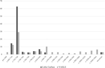
From the plough zone, 113 coins of the period c ad 680–870 have been recovered, in addition to four further coins discovered in context during excavation.Footnote 25 An overview of the coinage by ‘Naylor Groups’ reveals coin loss beginning c ad 680, with a significant peak in loss occurring with the secondary sceattas of Group 3 (ad 710–40), and relatively low levels of loss across the following century and a half (table 1).Footnote 26 The apparent lack of monetary activity at Little Carlton prior to c ad 680 is in contrast to other similar sites in the region such as Garwick near Heckington, Lincolnshire.Footnote 27 When compared to the national pattern, however, coin loss at Little Carlton is not unusual except in terms of the quantity of coinage found on the site (fig 17).Footnote 28 The same is true with the peak in coinage in Group 3, which merely reflects the proliferation of Frisian sceattas in use during the opening decades of the eighth century, a phenomenon that saw a massive influx of silver coinage into England from the Continent.Footnote 29 Similarly, the relative lack of coinage in Groups 4 onwards at Little Carlton is reflected in the national profile of coin loss.Footnote 30 Accordingly, while the concentration of coins at Little Carlton is unusual, the general temporal pattern is mirrored at both national and regional levels.Footnote 31 Comment might be made, however, on the relatively high proportion of Series J sceattas contained within Group 3 (twenty-five of ninety-seven coins), more than any other site in Lincolnshire, particularly given these coins were probably issued somewhere in Lindsey.Footnote 32
Metal-detected sceattas.

Comparison between the Little Carlton coinage ‘fingerprint’ and the Viking and Anglo-Saxon Landscape and Economy (VASLE) east central England dataset (after Richards et al Reference Richards, Naylor and Holas-Clark2009, fig 80). Graph: authors.

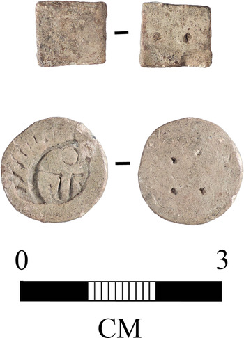
Non-numismatic evidence for economic trade is evidenced by two lead counters, both of which appear to have been used as coin weights (fig 18). The first weight is circular in plan, measuring 16mm in diameter and 3mm in thickness, and is decorated on both sides.Footnote 33 The ‘obverse’ bears a motif resembling the inverse impression of a Series E ‘porcupine’ sceatta. The ‘reverse’ bears four circular indentations, arranged to form a square. The object weighs 4.63g, approximately four times the weight of a standard Series E sceatta. The second lead weight is rectangular with neatly cut sides, decorated on one side only with two circular indentations.Footnote 34 This weight has a mass of 2.42g, equating to approximately two Series E sceattas. A third rectangular weight, very similar in form to the latter item, is known from a plough zone context at Benniworth, Lincolnshire.Footnote 35 This item bears five circular indentations and, weighing 5.32g, represents the total weight of approximately five sceattas.
Metal-detected coin weights. Photograph: Portable Antiquities Scheme and authors.

OBJECTS ASSOCIATED WITH LITERACY AND THE CHURCH
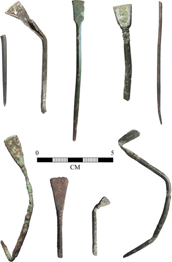
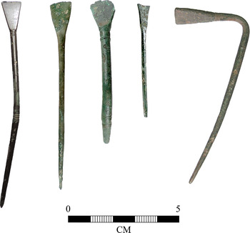
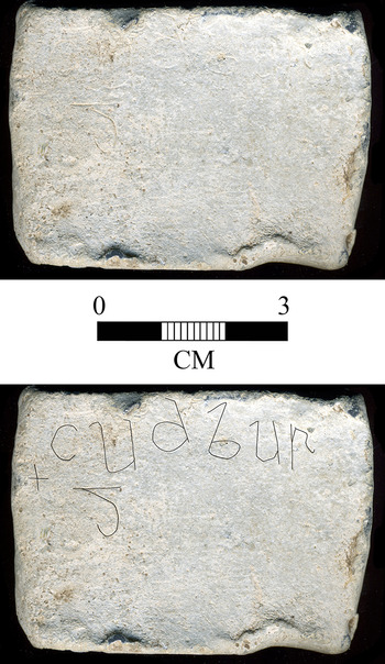
In addition to the four styli found during the excavations, a further twenty-four examples have been recovered from metal detecting on the island. The Little Carlton styli corpus is thus the largest ever recovered from any site in Britain, and also exceeds the cumulative finds of styli from Lincolnshire as a whole (figs 19 and 20). The assemblage is broadly similar to the twenty-two examples found at Flixborough and the three from Brandon, the majority being of copper alloy, although one made of silver and another of iron were also recovered.Footnote 36 Literacy is also evidenced by an inscribed lead tablet (fig 21), perhaps used in a funerary context, bearing the Old English female personal name ‘Cudburg’. According to Okasha, the script used is of a form that seems consistent with a date earlier than the early tenth century and could well have been executed by someone accustomed to writing on vellum.Footnote 37 A final category of find encountered during metal detecting is represented by fragments from fifteen copper-brazed iron hand bells (see Appendix SM4), a class of material culture that has been argued to have had close connections with the early church.Footnote 38
Metal-detected styli 1/2. Photograph: Portable Antiquities Scheme and authors.

Metal-detected styli 2/2. Photograph: Portable Antiquities Scheme and authors.

Lead plague inscribed with the name ‘Cudburg’. Photograph: Portable Antiquities Scheme and authors.

LITTLE CARLTON IN CONTEXT
From its finds profile, Little Carlton bears comparison with the most prolific of the metal-rich sites in eastern England that have been subject to extensive excavation, such as Flixborough and Brandon.Footnote 39 Both places have been identified as monasteries, and many scholars see the majority of metal-rich sites in a similar light.Footnote 40 As others have already highlighted, however, no material culture is diagnostic of ecclesiastical activity, and indeed the validity of seeking such a signature is highly questionable.Footnote 41 This is especially true for the period in question, given that the Church increasingly became the embodiment of elite consumption from the seventh century onwards. Indeed, from their inception clerical communities were founded, sustained and populated by royal and sub-royal individuals.Footnote 42 Given these conditions, it is debatable whether, in the earlier part of the period in particular, ecclesiastical foundations were distinguishable from other high-status centres.
While it is not currently possible to offer as detailed chronological sequence for Little Carlton as might be liked, an outline biography of the site and the people who shaped it, derived from archaeological analyses, can be offered. In addition to a comparative analysis with other contemporary centres, the character of the site can be brought further into focus, first by comparison with other archaeological evidence, and then with data derived from alternate sources. In terms of the chronological development of Little Carlton, the first noteworthy observation is that, akin to other metal-rich concentrations of the period, the location appears to have been important before the seventh century. The recovery of an amphora-shaped strap-end and a penannular brooch allude to activity some time before the use of settlement structures or burial in the seventh century. It is tempting to interpret this phase, albeit deriving from a slight dataset, as an example of what Hodges calls a ‘gateway community’: trading sites typically situated near the coast that were used either seasonally or episodically.Footnote 43 The peninsula setting of Little Carlton would undoubtedly have benefited mercantile enterprise, but there may also have been a symbolic rationale behind the choice of the site. Deposition of objects in the pool at the centre of the island, for instance, is unlikely to have been an innovation of the early medieval period, but instead a long-established practice originating in prehistory. Archaeological evidence for this early activity is by its very nature opaque, but research into landscapes such as the Witham Valley in Lincolnshire demonstrates the longevity of such votive deposition, persisting uninterrupted by changes to the broader social, political or formal ‘religious’ fabric.Footnote 44
The presence of at least one barrow on the southern part of the marsh island at Little Carlton has also been demonstrated through excavation and, whether representing a reused prehistoric monument or a de novo construction of the early medieval period, reflects a desire to ‘create continuity’ with a real or imagined past.Footnote 45 Burial practice may also have been used to claim ownership or legitimacy over the site, as evidenced by the interment of female skeleton SK46. Despite indications of tight wrapping before burial, the arrangement of the skeleton strongly suggests that this burial was disturbed post mortem, probably as a result of reopening. This event must have occurred some time after initial burial, as the remains were disarticulated. The phenomenon of grave reopening is well-recognised across Western Europe in the early medieval period, and is especially prevalent during the seventh century. In England a dozen or so confirmed or suspected examples of the practice have been identified through excavation, including at Westfield Farm on the Isle of Ely, Cambridgeshire, and at Wolverton, Buckinghamshire.Footnote 46 The motivations behind the reopening of graves are somewhat unclear, but are likely to have been varied. Instances in which grave goods have been removed may point to mal-practice, perhaps by rival kin-groups seeking to destroy or obtain for themselves symbolically important objects.Footnote 47 In other cases it may have been the body itself that was the target of manipulation or ‘maiming’, perhaps in an attempt to subdue perceived revenants and their supernatural power.Footnote 48 Reopening need not have been driven by malice, however. The burial of leading persons was central to legitimising newly-gained holdings in early medieval society, as illustrated by Helena Hamerow in her study of well-furnished female burials dating to the seventh century.Footnote 49 Although SK46 was found in an unfurnished grave, similar processes may have been at play at Little Carlton, the importance of the individual to the community reflected by the effort to disinter them from their original resting place for reburial at the site.
The floruit of activity detectable from the late seventh century onwards may, therefore, have been partly a product of organic growth over decades or centuries, although the broad dating of much of the archaeology limits precise reconstruction of Little Carlton’s nascent stages. It should not be assumed that the use of the site in the post-Roman centuries was necessarily of low intensity or frequency, however, but instead acknowledge that the period is characterised by a more ephemeral archaeological signature than its later phases. The low level of early coin loss at Little Carlton compared with other centres in the region could be seen to support a model of continued organic growth into the later seventh century, although other evidence hints at a genuine event horizon around the year ad 680. It is unlikely to be a coincidence that coinage appears in the archaeological profile at the same time as the first burials, suggesting an important step-change in the biography of the site. This watershed corresponds with wider developments in commercial activity across England from the late seventh century, most clearly manifest in the rise of coastal emporia but also detectable in the diversification of settlement types more generally.Footnote 50 Metal-rich places represent one element of this stratification, with the east coast lying in a particularly abundant zone around the North Sea, where accessibility to the Continent provided enhanced opportunities to acquire imported high-status goods.Footnote 51
Indeed, it is from this eastern zone that some of the most valuable insights into metal-rich places have been made, through excavations at the settlement of Flixborough, overlooking the River Trent and 8km south of the Humber Estuary. Christopher Loveluck proposes that the site was subject to a sequence of complex settlement evolution, indicative of changing modes of elite display. In this model, conspicuous consumption during the seventh and eighth centuries was supported through direct exchange with mariners and ports as well as intensive agricultural exploitation, attributes which Loveluck argues ‘encapsulates the secular elite milieu of the coast’.Footnote 52 This consumptive lifestyle appears to have shifted during the ninth century when Flixborough’s economy was instead geared towards specialist production, perhaps for export to a parent centre. The possibility that settlement could undergo such considerable changes of character over time has major implications for understanding Little Carlton, particularly as the sequence at Flixborough was only discernible due to excellent surviving stratigraphy. Indeed, in what now reads as an almost prophetic observation of conditions at Little Carlton, Loveluck imagined that if Flixborough had been ploughed out and metal detected, it would have been seen as a site of intense eighth- and ninth-century activity before abandonment in the tenth or eleventh centuries.Footnote 53 Like Flixborough, then, the character of occupation at Little Carlton may too have been mutable, our ability to view such dynamism being obscured by comparatively poor levels of preservation and the limited extent of excavation to date.
Looking beyond the site, our current understanding of elite activity in East Lindsey during the early medieval period has recently been advanced by David Stocker and Paul Everson’s research into the documented monastery at Louth. Prompted by the discovery of pre-Conquest sculpture in the market town, the pair have reassessed the setting of the early church and contended that the main complex lay within a valley in an area later occupied by Westgate.Footnote 54 A case now exists that Louth acted as one of two pre-Viking episcopal centres in Lindsey, initially developed as a cenobitic house but subsequently reformed into an institution of secular clergy in the early ninth century.Footnote 55 Although this detailed analysis dispels the possibility that Little Carlton itself represents the site of ‘Hludensis monasterii’, first documented in ad 790, it does prompt consideration of the relationship between the two establishments in the period. Exactly when the episcopal interest in Louth first developed is uncertain, but is perhaps datable to around the year ad 679, when the Battle of Trent saw Lindsey finally and decisively come under the orbit of Mercia.Footnote 56
It is noteworthy that the proliferation of finds, buildings and burials at Little Carlton broadly coincides with these political developments, and it is perhaps under the aegis of the Mercian elite that the site was promoted, along with Louth, in their newly-conquered lands. On the Continent, scattered elements of Church estates frequently correspond to important shipping and trading centres, and in England ecclesiastical ownership at even the largest ports is evidenced by grants such as that to Chertsey Abbey in ad 672–4, which gave property ‘by the port of London, where ships put in’.Footnote 57 As Katharina Ulmschneider has shown, continental monasteries also made extensive use of villa-markets; sites of markets or fairs promoted by the Church, but which did not necessarily function or develop into central places. She contends that in England some metal-rich sites may represent such villa-markets, as many are located on important nodes in transport and communication networks and in close proximity to early churches.Footnote 58
It is tempting to graft this framework onto the evidence from East Lindsey, yet the nature of the association between Little Carlton and Louth, if there was any, is difficult to discern. It is a trap of historic research agendas that, where a monastery or other centre is documented, all contemporary settlement is assumed dependent. Such an outlook would interpret Louth, because it is recorded in written sources, as the settlement of leading import in early medieval East Lindsey, but from an archaeological viewpoint it is Little Carlton that is pre-eminent. A more tenable interpretation, which overcomes the disparities in the available data, is to see these two centres as part of a wider high-status ‘meshwork’, components of an entire landscape that was exploited to meet the economic, social and political needs of elite authorities.
Despite its situation in a nodal point in the regional communication network, Little Carlton is unlikely to have acted merely as a ‘point of entry’ and was not necessarily utilised sporadically, as might be assumed. The adjacent coastline provided prized maritime contacts but also access to crucial resources such as salt, for which Mercia had previously had to depend on Droitwich.Footnote 59 The evidence from Fishtoft near Boston provides an example of the kind of exploitation probably carried out along the coast at the time, and the importance of salt to the local economy of Little Carlton is reflected in later sources, including those relating to the adjacent failed medieval new town of Castle Carlton.Footnote 60 Lacking direct evidence for salt production in the early medieval period, recent excavations have nevertheless shown that Little Carlton was clearly a place of production, some of which is likely to have been transported into the region.
It is challenging to demonstrate permanence in occupation of a site through archaeological remains, but the balance of material from Little Carlton argues for rather more than the sporadic or seasonal use one might associate with a market or fair. The construction of at least one large building and the establishment of perhaps one, or more likely two, large cemeteries represents substantial investment. The execution of specialist industrial processing, such as bell making, would have required considerable coordination of labour and resources. Those occupying Little Carlton also invested heavily in practices the meaning of which are less clear, but all of which find comparators in the early medieval period. For instance, structured deposition using natural features is known from many excavated sites,Footnote 61 but has been demonstrated most compellingly by Gabor Thomas who noted the use of a sink-hole for the discard of objects at the high-status settlement of Lyminge, Kent. Thomas cites the work of Bronze Age scholars, who have suggested that such features acted as cosmological portals to the Otherworld, and those using the pond at Little Carlton may have held similar beliefs.Footnote 62
The importance of the activities taking place at the pond is likely to have been amplified by architectural setting, framed on one side by a building that had been pointedly enhanced through the construction of a veranda. At the water’s edge, too, and adjacent to the platform from where the most valuable artefacts were discarded, was erected a large pole or post. The concept that trees and posts were seen as ‘holy’ in early medieval society is relatively well established, but the significance of their use in settlements and landscapes has been most convincingly illustrated by John Blair.Footnote 63 In addition to acting as edifices of worship and as places for assembly, posts could be employed to structure the architecture of a site, as at Yeavering in Northumbria where during the seventh century a post-setting inserted into the ‘Eastern Ring-Ditch’ acted as an axial point for a precisely structured sacred geography.Footnote 64 Such insights strongly suggest a cultic aspect to at least some of the activities taking place at Little Carlton, most probably encouraged by the physical setting of the site. A coastal island with a naturally-accumulating central pool, such a place is likely to have been perceived as physically and cosmologically liminal, and attracted the indigenous practices visible in the material signature as a result.Footnote 65
Little Carlton is, therefore, a site with a complex and evolving biography, which is best understood through careful consideration of the archaeological evidence. While the metal finds were key to the initial identification of the site, the excavated material has been crucial in determining the character and wide variety of activities that were undertaken. Forming one element of a high-status ‘meshwork’, Little Carlton was a key centre of trade and exchange, but also an appropriate location for settlement, burial and the performance of deeply meaningful indigenous practice.Footnote 66 Although for the purposes of this assessment the focus of discussion has been on developments between the seventh and ninth centuries, it is worth considering here the later biography of Little Carlton, or the ‘afterlife’ of the finds-rich phase. Our knowledge of the site after the middle of the ninth century is especially inhibited by the restricted size of investigation and is a period characterised by an almost non-existent finds profile. As the excavations at Flixborough demonstrate, this drop in material culture may not denote wholesale abandonment but, rather, a change in economy coupled with a shift in the settlement focus, perhaps towards the area around the parish church, which has not been subject to excavation.
The sustained importance of Little Carlton into a later period is undoubtedly supported by the aforementioned identification of the grave cover of later tenth- or eleventh-century date during the dismantling of the church,Footnote 67 one of several in the East Lindsey district dedicated to St Edith and conceivably dependencies of Louth.Footnote 68
One final strand that alludes to a persisting elite significance at Little Carlton is found in the chartulary of nearby Legbourne Priory, which details the foundation of the house by Robert FitzGilbert of Tathwell in around ad 1150. The priory was apparently established for nuns who previously resided in a site known as Carledale, but the chartulary also alludes to nuns from Keddington and Hallington.Footnote 69 There has been uncertainty whether these citations represent distinct foundations or whether the same house is being referred to by different names, although given the geographical separation of the villages of Keddington and Hallington, situated 4km apart on opposite sides of Louth, surely the former is the more likely. The location of Carledale is uncertain but the place-name and topographic setting of Little Carlton, situated at the bottom of an open valley, certainly commend it as a candidate. The existence of a small cell of nuns at Little Carlton into the twelfth century is an intriguing proposition. It is tempting to see this as the slightest fragment of continued high-status activity from its previously distinguished past, and serves to emphasise further the value in studying metal-rich places on a landscape scale and in long-term perspective.
ACKNOWLEDGEMENTS
The principal authors would like to acknowledge the significant contribution made by Adam Daubney to this paper; as the former Finds Liaison Officer to the Portable Antiquities Scheme, he was the first to realise the true significance of Little Carlton, and he has added to various sections of this paper. Likewise, Sophie Newman and Paul Blinkhorn have provided the contributions on the human skeletal remains and ceramics, while Peter Townend oversaw the geophysical and topographic survey undertaken at the site. We are, of course, indebted to Graham Vickers, whose responsible metal detecting and recording of artefacts first identified the site and greatly aided in its academic study, and to Roger Taylor and his family, on whose land the site lies, who gave permission for the fieldwork to take place. We are also grateful to all those with whom we have discussed our findings with, and in particular David Stocker who provided many useful comments on our interpretations. Finally, we would like to thank the Society of Antiquaries of London, who generously funded this project.
SUPPLEMENTARY MATERIAL
To view supplementary material for this article, please visit https://doi.org/10.1017/S0003581521000160.