Introduction
Sedimentological and geochronological studies of paleodunes provide fundamental insights into their development and environmental significance.These studies are crucial in unraveling the paleoclimatic and paleoenvironmental patterns established during the Quaternary in the South American continent (Tripaldi and Zárate, Reference Tripaldi and Zárate2016). In Brazil, paleodunes have been identified from the Paraná River basin, through the semiarid northeast and alluvial fans of the Taquari River (Pantanal), to the alluvial plains of the Amazon. They may constitute unique records of prolonged drought and wind dynamics during the Pleistocene–Holocene in these regions, as Da Silva et al. (Reference Da Silva and Corrêa2023) emphasized.
In general, coastal dunes have been better studied (Giannini, Reference Giannini1993; Silva, Reference Silva2002; Sawakuchi et al., Reference Sawakuchi, Kalchgruber, Giannini, Jr Nascimento, Guedes and Umisedo2008; Fernandez et al., Reference Fernandez, Pereira, Rocha, Maluf, Moulton and de Oliveria Filho2017; Mescolotti et al., Reference Mescolotti, Giannini, do Nascimento Pupim, Sawakuchi, Ladeira and Assine2023) compared to inland dunes. The geographic isolation of inland dunes has hindered detailed sedimentological, geomorphological, and geochronological studies, which would allow an understanding of their genesis and temporal positioning.
In recent decades, data from remote sensing products, particularly in the Amazon, have identified kilometer-long sandy deposits with ridges aligned predominantly in the NE–SW direction. Geological and geochronological studies (Carneiro Filho and Zinck, Reference Carneiro Filho and Zinck1994; Latrubesse and Nelson, Reference Latrubesse and Nelson2001; Carneiro Filho et al., Reference Carneiro Filho, Schwartz, Tatumi and Rosique2002, Reference Carneiro Filho, Tatumi and Yee2003; Teeuw and Rhodes, Reference Teeuw and Rhodes2004; Carr et al., Reference Carr, Armitage, Berrío, Bilbao and Boom2016) associate their genesis with wind dynamics during the driest periods of the last glacial maximum. These findings are unique records of paleoclimatic changes in the northern portion of the South American continent during the Quaternary. Despite their large area, specific geochronological data (OSL) of these sandy bodies allowed them to be attributed to the Late Pleistocene–Holocene. They helped define the alternation of dry and wet periods established on the continent, particularly in the Amazon.
Most of the dune fields identified in the Amazon are located mainly in the lower areas of sedimentary basins. They are, therefore, fundamental to broaden the understanding of the interaction between fluvial and aeolian subenvironments. The development of these dune fields is a function of climatic seasonality, sediment availability, and wind action, where under specific conditions, fluvial deposits can be reworked by aeolian activity, giving rise to predominantly sandy deposits (Bullard and Livingstone, Reference Bullard and Livingstone2002; Carneiro Filho et al., Reference Carneiro Filho, Schwartz, Tatumi and Rosique2002; Teeuw and Rhodes, Reference Teeuw and Rhodes2004; Belnap et al., Reference Belnap, Munson and Field2011; Carr et al., Reference Carr, Armitage, Berrío, Bilbao and Boom2016; Tripaldi and Zárate, Reference Tripaldi and Zárate2016; Forman et al., Reference Forman, Wu, Wiest, Marin and Mayhack2023; Yuan et al., Reference Yuan, Xu, Liu, Zhang and Zheng2024).
The aeolian deposits identified in this study expand the area of occurrence to the alluvial plains of the Negro and Demini rivers, Middle Rio Negro Basin. The deposits have an irregular distribution, dissected relief, are inactive, and are stabilized by medium to large shrub vegetation, which makes it challenging to characterize the original depositional morphology. However, sedimentological, stratigraphical, and geochronological data allowed them to be associated with the main paleodune fields described in the Amazon by Carneiro Filho and Zinck (Reference Carneiro Filho and Zinck1994), Latrubesse and Nelson (Reference Latrubesse and Nelson2001), Carneiro Filho et al. (Reference Carneiro Filho, Schwartz, Tatumi and Rosique2002), Teeuw and Rhodes (Reference Teeuw and Rhodes2004), Carr et al. (Reference Carr, Armitage, Berrío, Bilbao and Boom2016), and Zular et al. (Reference Zular, Sawakuchi, Chiess, d’Horta, Demattê, Ribas, Hartmann, Giannini and Soares2019). In addition, new geochronological data (OSL) from this study provide evidence for at least two periods of aeolian activity in this part of the Amazon Basin. The first was placed in the Middle Pleistocene, beginning approximately 170 ka ago, with no correlates in South America. The second fits into the age spectrum of 32.6 ± 3.1 ka to 1.32 ± 0.14 ka from previous studies. In the general context, the sedimentological, stratigraphical, and geochronological data obtained demonstrate the complexity of the subject and highlight the need for further research to detail the sedimentation stages and understand the wind systems of South America, especially in the Amazon.
Study area
The study area, a unique region in the western portion of the Mariuá Archipelago, in the Middle Rio Negro region (Fig. 1), is characterized by its black waters, which are poor in nutrients and low in alkalinity, with dissolved organic matter (Ríos-Villamizar et al., Reference Ríos-Villamizar, Adeney, Piedade and Junk2020). The river in this section flows at a medium to low velocity (0.4 m/s) and has a limited capacity to transport suspended particles. However, it is noteworthy that coarse sediments, predominantly composed of sand and granules, are primarily transported as bedload (Marinho et al., Reference Marinho, Zanin and Filizola2021). In the lower course of the Rio Negro, the transport of suspended particles varies between 7106 and 8106 tons/year (Filizola and Guyot, Reference Filizola and Guyot2011). The climate in Central-Western Amazonia is tropical rainforest (Af), according to the Köppen scale, with average precipitation values of around 3000 mm/year, an average annual temperature of 25°C, and a relative humidity of approximately 90% throughout the year (Guyot et al., Reference Guyot, Molinier, Guimarães, Cudo and Oliveira1993).
(A) Map of South America, emphasizing the Amazonas State. (B) Location map of the study area within the boundaries of the State of Amazonas. (C) Location of the study area in the confluence of the Negro and Demini rivers indicating the paleodune sites (red dots).

The dynamics of the current circulation of lower-altitude winds in the Amazon are mainly from northeast and east directions, which are controlled by the North Atlantic tropical anticyclones and the annual north–south displacement of the Intertropical Convergence Zone (ITCZ). The ITCZ plays a crucial role in determining intensity of the trade winds. From December to January, when the ITCZ is positioned farther south of the continent, stronger winds from the northeast predominate, and when it is positioned farther north, less-intense trade winds from the east prevail (Carneiro Filho et al., Reference Carneiro Filho, Schwartz, Tatumi and Rosique2002).
Methods
Geomorphological analysis of the paleodunes was based on images from the Planet satellite (3 meters of spatial resolution; acquired on the www.planet.com/explorer platform) and images obtained from the Google Earth application. Images were acquired between August 1 and 31, 2023, with a preference for images with less cloud cover. The platform was accessed between November 1 and 5, 2023. These data sources allowed for the delimitation of areas and the identification of depositional morphological features with unprecedented accuracy. Locally, a three-dimensional elevation model of a paleodune located on the right bank of the Rio Negro (point JF-36) was generated from images acquired by a state-of-the-art drone (Mavic 2 Fly More Kit model average altitude of 60 m and resolution of 1.4 cm/ Pixel). The post-processing was performed in the Agisoft Metashape Professional Edition aerophotogrammetric software, where alignment of the photographs, creation of the dense cloud of points, and generation and texturing of the mesh were performed. Subsequently, the data were interpolated and digitized (Opendtect dGB), and the digital elevation model (DEM) and elevation contours were generated. Observations of the deposits were carried out during fieldwork (December 2021). Panoramic and columnar sections were documented according to the recommendations of Arnot et al. (Reference Arnot, Good and Lewis1997). Granulometric tests were performed on eight samples using a Malvern Mastersize 2000 laser granulometer at the sedimentology laboratory of the Brazilian Geological Survey (CPRM/Manaus). Grain surface texture analyses were performed on the sandy samples from points JF-11 and JF-46 (grain sizes 0.125–0.250 mm), which were analyzed by scanning electron microscopy (SEM) at the State University of Amazonas and classified according to Mahaney (Reference Mahaney2002).
Seven sand samples were collected using an aluminum tube (30 cm × 5 cm) and analyzed at the Federal University of São Paulo to determine OSL ages. The sediments were chemically cleaned with hydrogen peroxide (H2O2) for 24 hours to remove organic material, then washed with distilled water and immersed in 20% hydrogen fluoride (HF) for 2 hours to eliminate carbonates and remove negative-particle ionization from the surface of the quartz grains.. Afterward, the samples were immersed in 10% hydrochloric acid (HCl) for 2 hours to eliminate possible fluorides, which were formed with an HF bath and washed with distilled water. Finally, the sample was immersed in sodium polytungstate (SPT; Na6[H2W12O40]) to eliminate feldspar (2.62 g/cm3) and heavy minerals (2.75 g/cm3) to obtain pure quartz grains. For OSL measurements, aliquots with a mass of approximately 3 mg, consisting of grains between 75 and 150 µm, were used to determine the equivalent dose (D e).
The contents of natural radioisotopes were determined by gamma spectroscopy; the spectra were measured with a Pure Hyper Germanium detector from Canberra Inc. and compared with results obtained by soil standards (JR-1, JB-3, JG1a, and JG-3). Contributions of cosmic radiation were calculated with the equations of Prescott and Hutton (Reference Prescott and Hutton1994). Finally, the annual dose rate (AD) values were calculated using the concentrations of U, Th, and K-40 and the conversion table for the dose rate of Adamiec and Aitken (Reference Adamiec and Aitken1998).
OSL measurements were performed using an automated TL/OSL reader, model Risø TL/OSL-DA-20, with blue light excitation (470 nm) and detection in the UV region using a U-340 optical filter. The samples were irradiated with a sealed beta source of 90Sr/90Y, with a dose rate of 0.067 Gy/s. The preheat of 200°C for 10s followed each regeneration dose, and for dose tests, the aliquots were heated at 160°C for 10s. OSL measurements were performed at 120°C for 40s. Equivalent doses (D e) were determined by the single-aliquot regeneration (SAR) protocol (Wintle and Murray, Reference Wintle and Murray2006), applied to 24–48 aliquots. The aliquots that passed the recycling test with values lower than 10% and the dose recovery test with values of less than 5% were used for the final dose calculation. For the final determination of the D e, the Central Ages Model was used with overdispersion (OD) values below 30% (Galbraith et al., Reference Galbraith, Roberts, Laslett, Yoshida and Olley1999; Galbraith and Roberts, Reference Galbraith and Roberts2012), and the D e was plotted in the graph “Radial Plot” by the NumOSL program (Peng et al., Reference Peng, Dong, Han, Long and Liu2013).
Results
Aeolian deposits with dimensions ranging from tens of meters to approximately 2 km in diameter are scattered along the banks of the Negro and Demini rivers (Figs. 2–6) and stand out in the relief with an altimetric variation of up to 10 meters from the surrounding muddy (silt and clay) alluvial plain. This altimetric variation is a significant feature because it highlights the topographical difference between the deposits and the surrounding area, as shown in the image and the digital model of Figure 5A and 5B. In general, the deposits exhibit a slightly arched morphology and are directed towards NNE, arranged at elevations of 30–39 meters above sea level, with elongated tails in the NE–SW direction, and stabilized by medium-sized shrubby vegetation. At the top, the aeolian deposits exhibit dissected relief, with relict portions of the preserved depositional morphology, defined by gentle undulations of meter-scale ridges and depressions that isolate inter-dune lakes of varying sizes and are predominantly rounded (Figs. 3 and 6). Locally, the deposits are truncated by the channel of the Demini River, in addition to exhibiting accretionary portions defined by bars of the alluvial plain of this river (Fig. 2A).
(A) Google Earth image showcasing the unique features of the paleodune sites located on the bank of the Demini River (points JF 09 and 11, shown in Figure 1). These features include a dissected relief with smooth elevations highlighting ridges oriented to NW (black lines), with shrubby vegetation at the top. The areal extent of paleodunes (delimited by a yellow dashed line) is truncated by accretional bars (white arrow) of the alluvial plain of the Demini River. The panoramic (B) and columnar sections (C, D) of the eastern edge of the paleodune show the predominance of sand with internal lamination and indicate the sampling sites and ages.

(A) Google Earth image showing the paleodune (dashed white line) on the bank of the Rio Negro (Point JF 46 in Figure 1), with its slightly arched shape for N–NE migration and isolated interdunes lake. (B) The dune surface shows ridge and depression relief. (C, D) The dune has a predominantly sandy composition (columnar section and D); samples marked for grain size analysis and OSL ages in the excavated trench (C and D).

(A) Google Earth image of the paleodune on the bank of the Rio Negro (Point JF 43, in Figure 1), with a slightly smooth arch to N-NE. The surface shows wavy relief of ridges and depressions (in B) and predominantly sandy composition (columnar section and C), with marked sampling OSL ages.

(A) Google Earth image of the paleodune on the bank of the Rio Negro (Point JF 36, in Figure 1). (B) the digital elevation model (DEM) indicates a ∼10-meter difference between the paleodune and surrounding alluvial deposits. The surface shows the relief of ridges and depressions (B and C), the predominantly sandy composition (columnar section and D), and marked sampling sites for grain size and OSL ages.

(A) Google Earth image of the paleodune on the bank of the Rio Negro (point JF 45 in Figure 1), highlighting the arched morphology to the NE, which isolates the interdune lake. The surface displays wavy relief of ridges and depressions (B) that isolate intermittent rounded lakes (C).

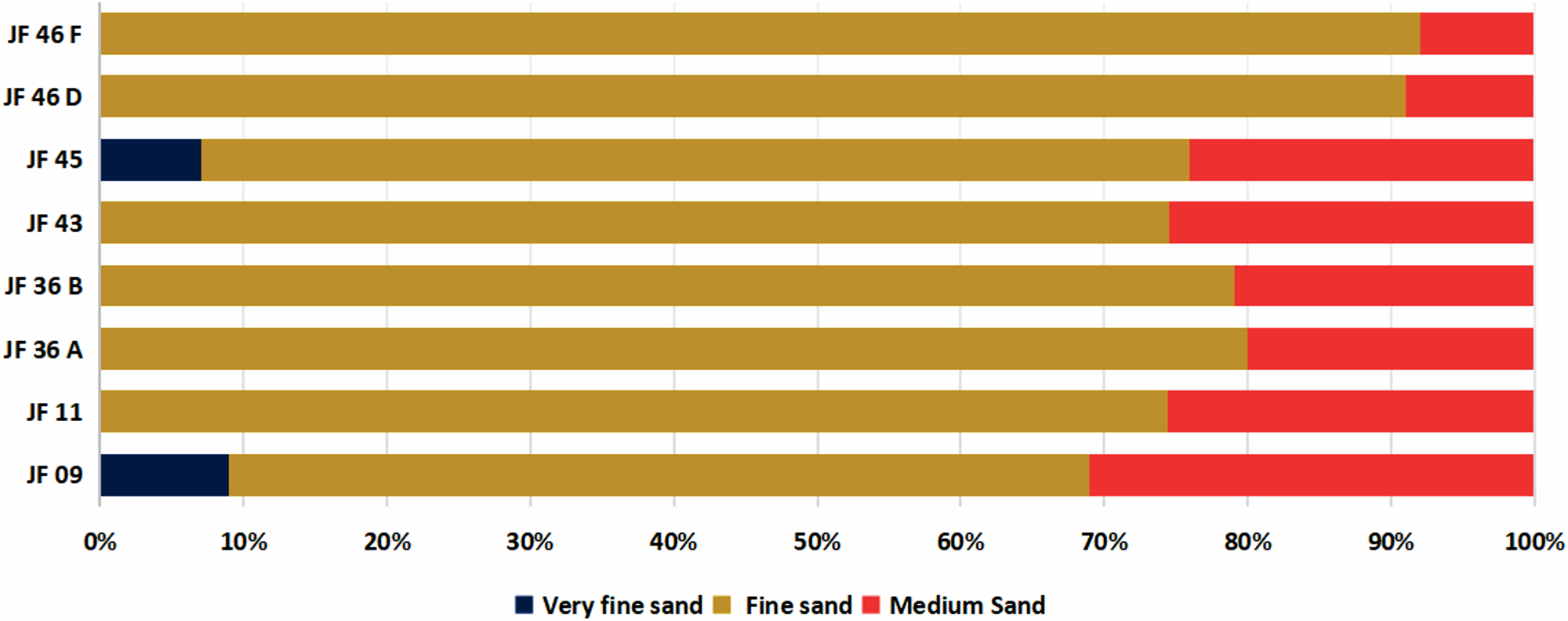
The deposits are tens of meters thick at outcrop and, internally, are predominantly whitish, with yellowish portions (oxidation) near the surface, and have a massive appearance with local occurrences of tenuous plane-parallel lamination (Figs. 2–5). They consist mainly of quartz grains and, to a lesser extent, of feldspar and opaque minerals, which vary from angular to sub-rounded with low sphericity (Figs. 9A and 10A). They exhibit good to moderate sorting, with predominantly very fine-grained sand varying up to the medium-grained sand, in addition to scattered occurrences of quartz granules (diameter of up to 0.5 cm; Fig. 7) and charcoal fragments (up to 2 cm in diameter; Figs. 3B and 5B). Near the surface, the deposits are bioturbated by subvertical to subhorizontal cavities of recent roots.
Grain size distribution (by fractions) of the paleodunes, highlighting the predominance of the fine- to medium-grained sand classes. This characteristic plays a key role in the formation and stability of the dunes.

Microtextural analysis of the grains defined seven predominant features, resulting from physical and/or chemical processes associated with transport and deposition, represented by (1) impact marks (Im) (Fig. 10B, D–H; (2) craters (Cr) (Figs. 9C, D, H, and 10E); (3) bulbous edges (Be) (Figs. 9E–H, and 10B, D, H); (4) sinuous ridge crests (Cs) (Figs. 9B and 10B); (5) V-shape (Figs. 9F and 10C); and (6) linear steps (Ls). Locally, a seventh feature, associated with precipitation (Pc), was observed, characterized by subhedral microcrystals arranged inside craters and/or impact marks (Figs. 9C and 10F). The percentages of microtexture occurrences show that features originating from grain contact during transport, such as a sinuous ridge, impact mark, crater, linear step, and V-shape, are more abundant than those associated with post-depositional processes, such as precipitation (Fig. 11).
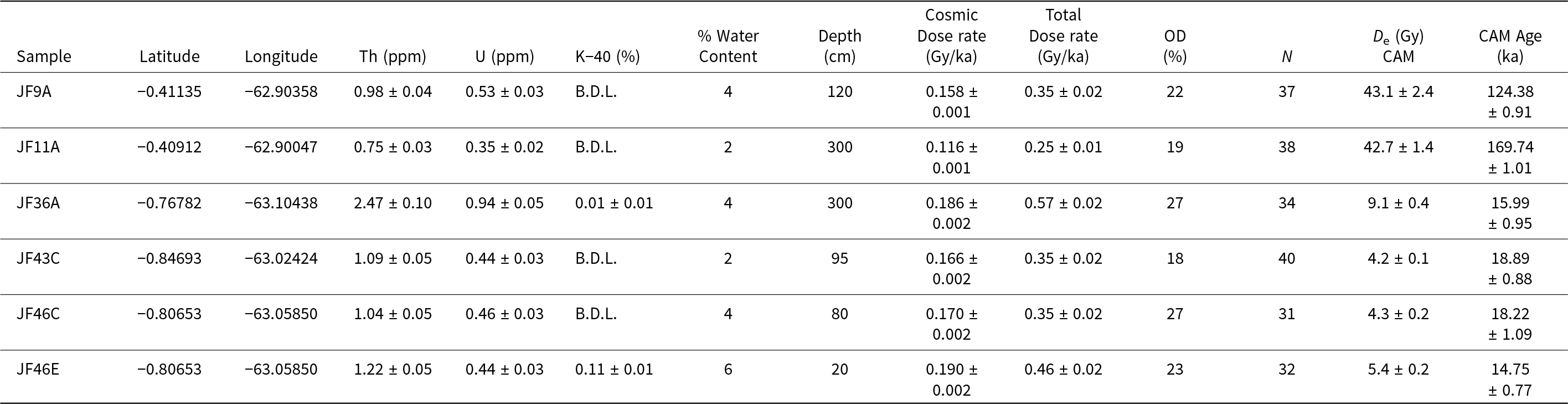
Our geochronological data obtained by OSL dating revealed distinct ages for the aeolian deposits analyzed. Outcropping deposits in the Demini River plain (points JF 09 and JF 11) provided ages between 169.74 ± 1.01 ka and 124.38 ± 0.91 ka, which are the oldest defined for Amazonia. In contrast, those of the Rio Negro (points JF 36, JF 43, and JF 46) were positioned between 18.89 ± 0.88 ka and 14.75 ± 0.77 ka (Table 1; Fig. 8).
Histograms of the statistical behavior of OSL ages (SAR protocol) of the paleodune deposits. A (JF 09A), B (JF 11A), C (JF 36B), D (JF 43C), E (JF 46C and F (JF 46E). The location of the sampling points is in Figure 1.

Samples analyzed in OSL dating study, radioisotope results, water contents, depths, and OSL dating results obtained by SAR protocol.

Discussion
Geomorphological, geochronological, granulometric, and microtextural data allowed the association of the sandy deposits studied in the Middle Rio Negro region with aeolian sedimentation in the Amazon—a topic that has been discussed in several studies (Carneiro Filho and Zinck, Reference Carneiro Filho and Zinck1994; Latrubesse and Nelson, Reference Latrubesse and Nelson2001; Carneiro Filho et al., Reference Carneiro Filho, Schwartz, Tatumi and Rosique2002; Teeuw and Rhodes, Reference Teeuw and Rhodes2004; Carr, Reference Carr, Armitage, Berrío, Bilbao and Boom2016; Zular et al., Reference Zular, Sawakuchi, Chiess, d’Horta, Demattê, Ribas, Hartmann, Giannini and Soares2019). Evidence of wind transport can be related to the external arched morphology of the deposits (Figs. 3A and 6A), as well as the ridge and depression features at the top (Fig. 2A), which exhibit a preferential NNE orientation. This orientation, contrary to the wind direction (NW–SE) estimated by Carneiro Filho et al. (Reference Carneiro Filho, Tatumi and Yee2003) for the Amazon dry wind corridor, allows associating the studied deposits with barchan-type dunes since they exhibit elongated “tails” in the wind direction and crests in the opposite direction (Pye and Tsoar, Reference Pye and Tsoar2009). In this context, morphological classifications have been used for the dune fields of the Branco and Negro rivers (northern Brazil), defined as parabolic, longitudinal, and linear (Latrubesse and Nelson, Reference Latrubesse and Nelson2001; Carneiro Filho et al., Reference Carneiro Filho, Schwartz, Tatumi and Rosique2002; Teeuw and Rhodes, Reference Teeuw and Rhodes2004; Zular et al., Reference Zular, Sawakuchi, Chiess, d’Horta, Demattê, Ribas, Hartmann, Giannini and Soares2019), and for the Colombian and Venezuelan Llanos, defined by Carr et al. (Reference Carr, Armitage, Berrío, Bilbao and Boom2016) as linear.
Potential applications of the relationship between granulometric and textural aspects and sediment transport
The predominance of fine-grained sand in the studied sandy deposits indicates a bimodal distribution pattern, which may be related to wind selection, even at short distances, where changes in wind direction and speed result in smooth granulometric differentiation, as emphasized by Maia (Reference Maia1998). Grain size bimodality of the deposits may be associated with a saltation component during wind transport (e.g., Pye and Tsoar, Reference Pye and Tsoar2009) and described in the dunes of the Paiku Co Basin, Southern Tibetan Plateau (Yuan et al., Reference Yuan, Xu, Liu, Zhang and Zheng2024). In the Amazon, this component may be associated with the seasonal pattern in wind direction, which repeats in cyclical periods, with a tendency in the ENE direction in the driest periods and E or ESE in the wetter periods (see Latrubesse and Nelson, Reference Latrubesse and Nelson2001; Carneiro Filho et al., Reference Carneiro Filho, Schwartz, Tatumi and Rosique2002, Reference Carneiro Filho, Tatumi and Yee2003).
In the present study, the inference of wind transport is corroborated by the predominance of microtextures associated with shocks and contacts between grains, with emphasis on impact marks, such as craters, bulbous rims, and V-shapes, which were also identified in several studies in the Tibet region (Yuan et al., Reference Yuan, Xu, Liu, Zhang and Zheng2024) and in the northern Amazon (Figueiredo and Wankler, Reference Figueiredo and Wankler2012). The predominance of these microtextures can be associated with damage caused during wind transport due to the high energy involved, which generates irregularities on the surface of the grains (Nichols, Reference Nichols2009). In this context, crater and bulbous-rim microtextures were identified in ancient and recent aeolian paleodunes of Portugal by Costa et al. (Reference Costa, Andrade, Mahaney, Marques da Silva, Freire, Freitas, Janardo, Oliveira, Silva and Lopes2013). In addition, impact marks and craters were associated with the final phase of wind transport in paleodunes of Tunisia (Chakroun et al., Reference Chakroun, Miskovsky and Zaghbib-Turki2009). In particular, the shock-mark microtexture identified in the aeolian deposits of Northern Amazonia (border between Brazil, Venezuela, and Guyana) by Figueiredo and Wankler (Reference Figueiredo and Wankler2012) corroborates the interpretation of wind transport.
Furthermore, the linear-steps microtexture (Figs. 9D and 10E) suggests that the river first transported the grain, which was subsequently reworked by the wind over a short distance (Yuan et al., Reference Yuan, Xu, Liu, Zhang and Zheng2024). This hypothesis is corroborated by the joint presence of the V-shaped microtexture, which has its genesis associated with water transport (Mahaney and Rutter, Reference Mahaney and Rutter1992; Mahaney et al., Reference Mahaney, Sanmugadas and Hancock1996) and has been identified by Margolis and Krinsley (Reference Margolis and Krinsley1971) in transitional deposits between subaqueous dune–beach and aeolian dune and aeolian deposits associated with river systems (Yuan et al., Reference Yuan, Xu, Liu, Zhang and Zheng2024). In this context, the aeolian deposits studied near the Negro and Demini rivers may be related to reworking of fluvial sediments coming from the adjacent plains.
Surface micro-defections of the quartz sand from JF 11 (Figure 1). (A) Selected grains ranging from sub-angular to sub-rounded. (B–H) The main micro-defections (yellow arrows) observed: sinuous crest (Sc); impact (Im); crater (Cr); linear step (V-shape); precipitation (Pc); bulbous edge (Be). Based on Mahaney (Reference Mahaney2002).

Surface micro-defections of the quartz sand (from JF 46, Figure 1). (A) Selected grains ranging from sub-angular to sub-rounded. (B–H) The yellow square indicates the location of concentrated V-shaped microtextures. The main micro-defections (yellow arrows) observed: sinuous crest (Sc); impact (Ib); crater (Cr); linear step (V-shape); precipitation (Pc); linear steps (Ls); bulbous edge (Be). Based on Mahaney (Reference Mahaney2002).

The average percentage of occurrences of microtextures identified on the surface of the quartz sand in the paleodune at sites JF 11 and JF 46.

The alternation between wind and river transport is evident in the surface microtextures of the grains, which indicate the seasonality of the Negro and Demini rivers and the river–wind interaction. It is worth noting that the data presented are preliminary and localized, therefore the granulometric and microtextural discussions of the Amazonian wind deposits lack statistical data for complementary paleoenvironmental interpretations. It is also worth noting that the predominance of shock and impact microtextures in the grains of the studied quartzose deposits can be associated with eminent compositional maturity. At the same time, the high energy of wind transport enhances fragmentation of the less stable grains (feldspars and rock fragments).
Paleoclimatic context and stratigraphic correlation
Among the various methods applied to studies of Quaternary paleoclimatic events, palynological analyses integrated with absolute dating (radiocarbon and luminescence) are the most important (Klein et al., Reference Klein, Andren, Carter, Emery, Feldman, Fulkerson and Lyon1975; Irion et al., Reference Irion, Holm-Nielsen, Nielsen and Balslev1989; Suguio, Reference Suguio1999). However, it is critical to note that this type of research in the Amazon is remarkably scarce, and its application does not go beyond the Late Pleistocene (Soares, Reference Soares2007). The oldest paleoclimatic record, dated in absolute terms, comes from a lake in the Serra de Carajás and dates back approximately 60,000 years (Absy et al., Reference Absy, Cleef, Fornier, Servant, Siédine, Da Silva, Soubies, Suguio, Turcq and van der Hammen1991; Siffedine et al., Reference Sifeddine, Fröhlich, Fournier, Martin, Servant, Soubiès, Turcq, Suguio and Volkmer-Ribeiro1994) during a dry phase. However, most paleoenvironmental interpretations in the Amazon are based solely on palynological studies, with indications of vegetation changes on a regional scale (Liu and Colinvaux, Reference Liu and Colinvaux1985; Bush et al., Reference Bush, Colinvaux, Wiemann, Piperno and Liu1990; Colinvaux et al., Reference Colinvaux, Jackson, Budd and Coates1996; Siffedine et al., Reference Sifeddine, Martin, Turcq, Volkmer-Ribeiro, Soubiès, Cordeiro and Suguio2001).
It is vital to understand that paleoclimatic data indicate that the Intertropical Convergence Zone (ITCZ) is the primary system responsible for atmospheric control in the equatorial oceanic regions and nearby continents. The prolonged permanence of the ITCZ in one of the hemispheres significantly influences the rainfall regime and the intensity of the NE and SE trade winds (Uvo, Reference Uvo1989; Carneiro Filho et al., Reference Carneiro Filho, Tatumi and Yee2003; Zular et al., Reference Zular, Sawakuchi, Chiess, d’Horta, Demattê, Ribas, Hartmann, Giannini and Soares2019). During the last glacial maximum, migration of the ITCZ to the Southern Hemisphere caused longer periods of drought and strengthened the trade winds, intensifying seasonal variations in South America (Haug et al., Reference Haug, Hughen, Sigman, Peterson and Röhl2001; Maia et al., Reference Maia, Freire and Lacerda2005; Schneider et al., Reference Schneider, Bischoff and Haug2014). In this sense, aeolian deposits constitute relevant evidence of Quaternary climate change in the Amazon since several authors associate their origin with periods of greater aridity in aeolian corridors (Carneiro Filho et al., Reference Carneiro Filho, Schwartz, Tatumi and Rosique2002; Teeuw and Rhodes, Reference Teeuw and Rhodes2004; Tripaldi and Zárate, Reference Tripaldi and Zárate2016; Zular et al., Reference Zular, Sawakuchi, Chiess, d’Horta, Demattê, Ribas, Hartmann, Giannini and Soares2019).
In the Amazon, the dune fields of the Llanos of Colombia–Venezuela and northern Brazil (States of Roraima and Amazonas) stand out. They were deposited during the Middle Pleistocene–Holocene (Carneiro Filho and Zinck, Reference Carneiro Filho and Zinck1994; Latrubesse and Nelson, Reference Latrubesse and Nelson2001; Teeuw and Rhodes, Reference Teeuw and Rhodes2004; Carr et al., Reference Carr, Armitage, Berrío, Bilbao and Boom2016; Zular et al., Reference Zular, Sawakuchi, Chiess, d’Horta, Demattê, Ribas, Hartmann, Giannini and Soares2019) and are associated with aeolian activity.
OSL data obtained in this study allowed us to define two distinct records of wind activity in the alluvial plains of the Demini and Negro rivers, northern Amazonia. The deposits of the Demini River are older and were formed in the Middle Pleistocene, with no records of similar-age deposits in the Amazon. Despite the scarcity of dating data, several indications corroborate seasonal variations that were established over the Amazon during this period, including (1) placer deposits from the Pitinga Mine, north of Manaus, which have their genesis associated with deposition in a semi-arid climate and the absence of dense rainforest during the Mid Pleistocene (Haffer, Reference Haffer1992); (2) geomorphological changes in Rondônia (southern Amazon) were associated with a semi-arid climate during the end of the Tertiary and with arid climatic phases during the Pleistocene (Emmerich, Reference Emmerich1988); and (3) gypsum and aragonite precipitates in superficial deposits in the Acre sub-basin (Purus River) indicate dissection under arid climatic conditions, approximately 53,000 years ago (Kronberg et al., Reference Kronberg, Benchimol and Bird1991).
Aeolian deposits associated with the Rio Negro plain represent the most recent depositional phase, between 18.89 ± 0.88 and 14.75 ± 0.77 ka (Late Pleistocene). Currently, paleodunes have been identified mainly in the northern portion of South America (Fig. 12A and 12B). For example, the paleodunes located in the Llanos Colombians and Venezuelans are dated between 66 ka and 4.5 ka (Carr et al., Reference Carr, Armitage, Berrío, Bilbao and Boom2016), those identified by Teeuw and Rhodes (Reference Teeuw and Rhodes2004) on the border of Brazil and Guyana are dated between 17 ka and 15 ka. Paleodunes studied by Carneiro Filho et al. (Reference Carneiro Filho, Schwartz, Tatumi and Rosique2002, Reference Carneiro Filho, Tatumi and Yee2003) in the Negro and Araça rivers (northern Brazil) are dated between 32 ka and 7.8 ka years and those identified by Zular et al. (Reference Zular, Sawakuchi, Chiess, d’Horta, Demattê, Ribas, Hartmann, Giannini and Soares2019) in the southern state of Roraima (Brazil) are dated 21.9–17.2 ka.
(A and B) Approximate location of the paleodune sites at the basis of the geochronological correlation, mainly in northern South America. 1 to 10 are from previous studies, and 11 to 14 are from this study. (C) A map of the current primary annual precipitation (in millimeters) for the Amazon region, with identification of the wind-dry corridor determined by Carneiro Filho et al. (Reference Carneiro Filho, Tatumi and Yee2003) and the location of the study area (blue square).

In the sedimentological context, the fine- to middle-size sand grain variation encountered in the paleodunes is consistent with the fractions defined for inland sand dunes in various parts of the planet (Ahlbrandt, Reference Ahlbrandt and McKee1979) including the Amazon (Figueiredo and Wankler, Reference Figueiredo and Wankler2012). Genesis of the paleodunes and their sediments and transport is probably related to the change in the ITCZ position during the Middle to Late Pleistocene and Holocene, which in turn caused prolonged drier seasonal events in northern South America during the LGM (Haug et al., Reference Haug, Hughen, Sigman, Peterson and Röhl2001; Maia et al., Reference Maia, Freire and Lacerda2005). In this sense, Carneiro Filho et al. (Reference Carneiro Filho, Tatumi and Yee2003) associated the development of paleodunes in the Brazilian Amazon with “dry corridors,” where low humidity would have allowed transport and deposition of grains by wind. According to Carneiro Filho et al. (Reference Carneiro Filho, Tatumi and Yee2003), such corridors would have expanded during more prolonged aridity. In this corridor, the current annual precipitation does not exceed 1750 mm/year, configuring the driest zone of the Amazon. The principal bodies of paleodunes identified in this study and other regional works are located at its western limit (Latrubesse and Nelson, Reference Latrubesse and Nelson2001; Carneiro Filho et al., Reference Carneiro Filho, Schwartz, Tatumi and Rosique2002; Teeuw and Rhodes, Reference Teeuw and Rhodes2004; Carr et al., Reference Carr, Armitage, Berrío, Bilbao and Boom2016; Zular et al., Reference Zular, Sawakuchi, Chiess, d’Horta, Demattê, Ribas, Hartmann, Giannini and Soares2019) (Fig. 12C). Therefore, the presence of charcoal fragments in the studied paleodunes may indicate paleoburns during this period of aridity, according to similar records in Quaternary deposits in the Amazon (Absy, Reference Absy and Prance1982; Absy et al., Reference Absy, Servant and Absy1993; Santos et al., Reference Santos, Gomes, Anjos, Cordeiro, Turcq, Siffedine, Ditada, Cresswell and Fifeld1999; Turcq et al., Reference Turcq, Braconnot, Cordeiro, Sifedinne, Silva Dias, Abrão, Jorgetti, Lima Da Costa and Simões Filho2007; Moreira et al., Reference Moreira, Moreira-Turcq, Cordeiro and Turcq2009).
Furthermore, the palynological records and changes in the sedimentation pattern in Amazonian lakes are of utmost importance because they are related to paleoclimatic changes during the Pleistocene–Holocene. These findings, evinced by alternating dry and humid periods (Sifeddine et al., Reference Sifeddine, Martin, Turcq, Volkmer-Ribeiro, Soubiès, Cordeiro and Suguio2001; D’Apolito et al., Reference D’Apolito, Absy and Latrubesse2013; Sá et al., Reference Sá, Absy and Soares2016; Da Silva et al., Reference Da Silva and Corrêa2023; Maezumi et al., Reference Maezumi, Power, Smith, McLauchlan, Brunelle, Carleton, Kay, Roberts and Mayle2023; Beltran et al., Reference Beltran, de Toledo, Palace, Dibb and Bush2024), significantly contribute to our understanding of the Quaternary paleoclimatic events in the Amazon.
On the other hand, studies by Colinvaux et al. (Reference Colinvaux, De Oliveira and Bush2000) and Colinvaux and De Oliveira (Reference Colinvaux and De Oliveira2000) question the palynological, sedimentological, and geomorphological data presented for the Amazon, emphasizing that they are not indicative of periods of aridity in the Quaternary. Therefore, in the present study, the genesis of the aeolian deposits studied in the alluvial plains of the Negro and Demini rivers is not associated solely with periods of extreme aridity but is the product of an environment of fluvial-aeolian interaction. In this context, during the wet seasons, increased precipitation favors the supply of sandy sediments to the bars of the alluvial plain, which are subsequently reworked by the wind during subaerial exposure in dry periods. Examples of the interaction between fluvial and aeolian environments have been documented in the paleodunes of the Gran Chaco (Colombia) by Tripaldi and Zárate (2014) and the Red River (USA) by Forman et al. (Reference Forman, Wu, Wiest, Marin and Mayhack2023).
Conclusions
New geochronological (OSL) data have significantly advanced our understanding of the Amazon’s geological history. These data have allowed the definition of two sedimentation stages for the aeolian deposits exposed in the alluvial plains of the Negro and Demini rivers (northern Brazil), which were partially correlated with the main occurrences identified in the northern portion of the Amazon (Brazil, Colombia, Venezuela, and Guyana). The first period, dated to the Middle Pleistocene (169–124 ka), represents the oldest record of aeolian activity in the Amazon, with no paleoclimatic or geochronological correlates in the South American continent. However, despite the lack of absolute dating data, paleoclimatic changes prior to the Middle Pleistocene in the Amazon have been inferred through palynological, mineralogical, and geomorphological records, which were generally deposited in the Tertiary–Pleistocene. This research has provided crucial insights into the Amazon’s past, enhancing our understanding of its geological history.
While the available geochronological (OSL) data have shed light on the second stage of sedimentation, dated to the Late Pleistocene (18 ka and 14 ka), there is still much to be explored. This stage could be associated with the event of greatest aridity that allowed the formation of paleodune fields (32–8 ka) in northern Amazonia. The characteristics of this type of transport are recorded in the microtextures of the aeolian deposits studied, mainly the shock and impact features between grains. In addition, the integrated presence of microtextures inherited from river transport allowed a preliminary association of the genesis of the aeolian deposits located in the Negro and Demini rivers with reworking by wind of alluvial deposits exposed due to the seasonality of the Amazonian rivers. However, the geochronological and microtextural data presented are specific and require complementary paleoclimatic studies that would allow an improved correlation between the occurrences of aeolian deposits in the Amazon and the associated sedimentation stages. This underscores the urgent need for further research in this area.
Acknowledgments
The authors are grateful for financial support of the research project from Edital 001/2020 FAPESP-FAPEAM (processes 2020/08592-8 and 01.02.016301.00267/2021), the Scientific Initiation (IC) grant process of FAPESP 2022/16071-3, and Coordenação de Aperfeiçoamento de Pessoal de Nível Superior (CAPES-PRAPG, Edital 14/2023). We extend our thanks to the National Institute of Space Research (INPE) and the National Council for Scientific and Technological Development (CNPq) for the research grant (process 422354/2023-6), as well as to the Graduate Program in Geosciences (PPGGEO/UFAM) for laboratory and logistical support granted.