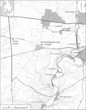


While the first part of this paper dealt with new discoveries in the area immediately around the stones at Stonehenge (Field et al. Reference Field, Linford, Anderson-Whymark, Barber, Bowden, Linford and Topping2014), this second part concentrates on the central area and the stones themselves. The work formed part of the Stonehenge World Heritage Site Landscape Project which was established by English Heritage in 2008 to provide fresh and up to date information for the proposed new Visitor Centre and to assist, support, and complement the work of the various universities that had become involved in research within the locality during the first decade of the century. It addressed a number of issues highlighted in the Stonehenge WHS Research Framework (Darvill Reference Darvill2005, 126–36) and not least the need for plans of the earthworks and mapping the surfaces of the stones (Bowden et al. Reference Bowden, Barber, Field and Soutarin press). In so doing it has allowed a re-evaluation of the traditional evidence and shed new light on a number of aspects that help place Stonehenge itself in a better spatial, chronological, and historical context. The project brought to bear an integrated array of non-invasive survey techniques, including earthwork analysis, geophysics, laser scanning, and aerial survey, together with documentary and archive research. All monuments in the World Heritage Site with a visible surface component were investigated, including the Greater Cursus and major barrow cemeteries but excluding Durrington Walls henge enclosure, which was recently comprehensively investigated by the Stonehenge Riverside Project, and Vespasian’s Camp hillfort, where there were access problems. Results of the work at each site along with details of the methodology used are available for download in the English Heritage Research Department Research Report Series (available online at http://www.english-heritage.org.uk/publications/research-reports) and readers are referred to these reports for a fuller account. A synthesis of the collected field evidence and a full outline of the project will be presented elsewhere (Bowden et al. Reference Bowden, Barber, Field and Soutarin press), while outstanding questions, not least those highlighted by the present work, are the subject of a revised Research Agenda currently in preparation. The present paper is concerned purely with the prehistoric periods and deals specifically with new data relating to Stonehenge itself (Fig. 1).
Stonehenge: location map showing the position of the World Heritage Site boundary (dashed line), with the ‘Triangle’ incorporating the English Heritage Guardianship area around the stones highlighted. ©English Heritage. Height data: Licensed to English Heritage for PGA, through Next Perspectives™

The stones themselves have been surveyed on a number of occasions, most recently in 1990 by M J Rees & Co for English Heritage (English Heritage Archives, Swindon) and the data, checked by survey grade GPS, have been reused here. During the early 1990s both magnetometer and resistivity surveys were carried out (Payne et al. 1995) alongside a photogrammetric survey (Bryan & Clowes Reference Bryan and Clowes1997) and these were revisited and the opportunity taken to introduce the use of Ground Penetrating Radar (GPR, Linford et al. Reference Linford, Linford and Payne2012). Additionally, both the ground surface and stones were recorded by laser scanning and this was supplemented by photogrammetric recording of the upper surfaces of the lintels and freestanding uprights; the stones were thus recorded in unprecedented detail (<0.5 mm resolution).
The Stones
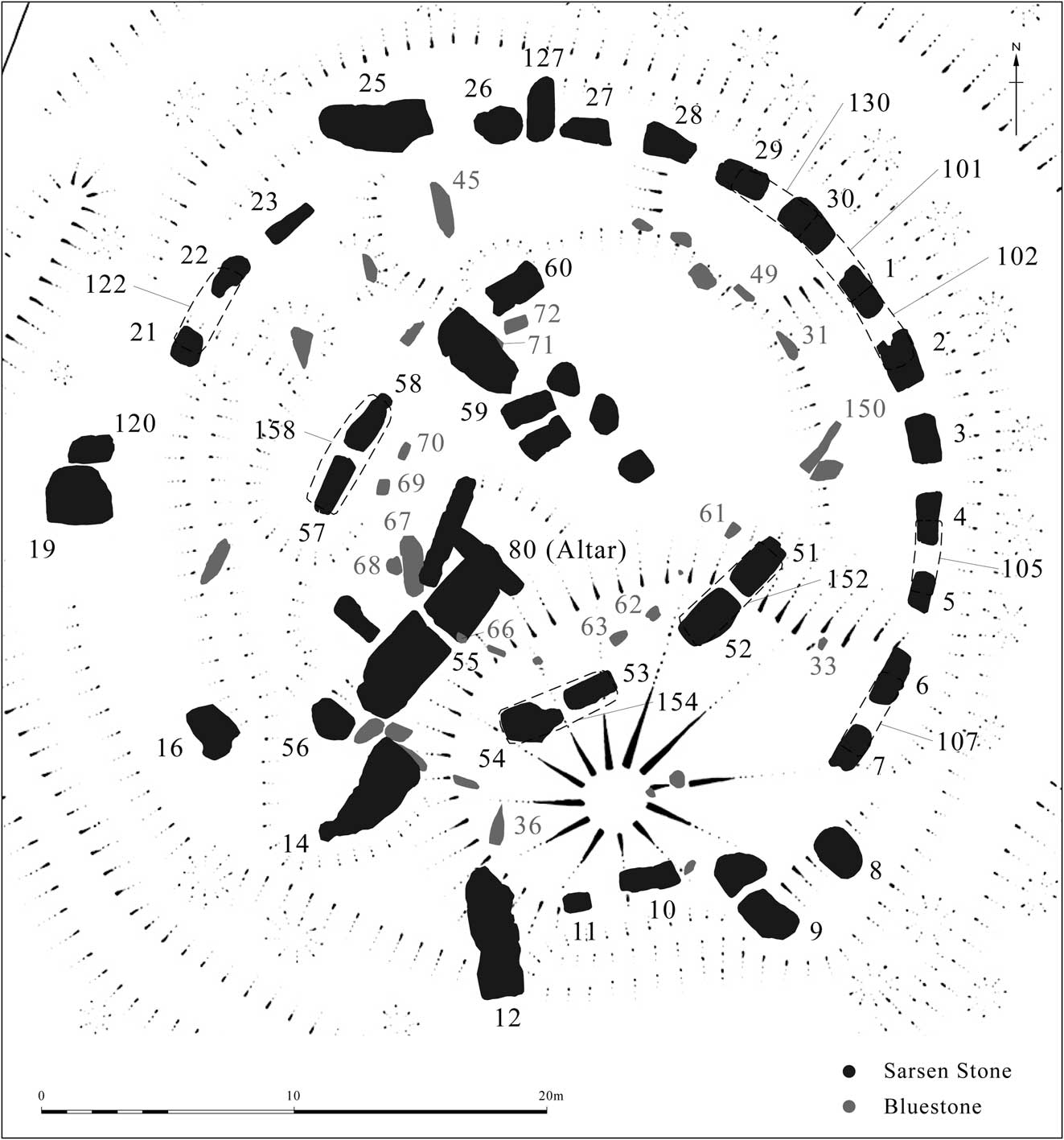
Eight-six stones are visible at Stonehenge, including four stumps (Fig. 2); the 20th century excavations revealed a further ten buried stumps making 96 in all. These stones are coarsely divided between the sarsens, a hard sedimentary silcrete, and the ‘bluestones’, a catch-all term covering a variety of rock types of distant origin including spotted/unspotted dolerite, rhyolites/rhyolitic tuffs (Ixer & Bevins Reference Ixer and Bevins2011; Bevins et al. Reference Bevins, Ixer, Webb and Watson2012), volcanic ashes, a Devonian sandstone (the Altar Stone), and other sandstones (Thorpe et al. Reference Thorpe, Jenkins and Watson1991). The ‘bluestones’ have long been considered to derive from off-site sources, principally the Preseli Hills of south-west Wales over 200 km away (Thomas Reference Thomas1923; Green Reference Green1997) and unique matches with spotted dolerite have been made at Carn Goedog (Bevins et al. Reference Bevins, Ixer, Webb and Watson2012; Reference Bevins, Ixer and Pearce2014). In contrast, sarsen is certainly present in the wider landscape and some have considered that the stones used for the sarsen settings may have had local origins. Sarsen stones occur across large parts of southern England, particularly in Wiltshire where they can be found in clusters on the Greensand deposits of the Pewsey Vale, in the Upper Thames Valley around Swindon, as well as on the chalk of Salisbury Plain and elsewhere, including around Stonehenge (Cunnington MSS book 9, Wiltshire Museum: Petrie Reference Petrie1880: Bowen and Smith Reference Bowen and Smith1977; McOmish et al. 2001, 151–2; Field & Pearson Reference Field and Pearson2010). As observed by Inigo Jones (Reference Jones1655, 33–4), they are found in ‘divers places about the Plain’ and are particularly numerous to the north ‘about Aibury’ and across the north Wessex Downs (Field Reference Field2005 and refs therein) and Rick Peterson’s recent discovery of William Stukeley’s 1723 drawing of shaped sarsen stones at Clatford near Avebury indicates that stones of sufficient size were once present there (Parker Pearson 2012, 297; Piggott Reference Piggott1948). Following the excavations and reconstruction work of the 1960s it is commonly assumed that those used at Stonehenge derive from the latter region (eg, Atkinson Reference Atkinson1956) although heavy mineral analysis carried out on samples from the Marlborough Downs and Stonehenge indicated considerable variation between them (Howard Reference Howard1982). Others, Flinders Petrie in particular, who carefully surveyed the stones and whose numbering system is used here, considered that the very position of Stonehenge may have been determined by the presence of a quantity of sarsen (Petrie Reference Petrie1880), while William Gowland (Reference Gowland1902, 75, 115), who excavated at Stonehenge at the outset of the 20th century, similarly thought the stones were brought from ‘no great distance from the spot where the structure stands’. The geologist Prof. J. W. Judd (Reference Judd1902, 115–6) considered that they had been moved ‘only a few hundred yards’, while H. H. Thomas (Reference Thomas1923, 242) also thought that they may have come from ‘the site of Stonehenge itself’. Johnson (Reference Johnson2008, 121) has suggested that the Heelstone is too awkward and bulky a shape to move on rollers and it, at least, is unlikely to have travelled far. Equally the much smaller Station Stones could easily have a local origin: it is, after all, possible to find larger stones on Salisbury Plain without having to travel to the Marlborough Downs for them.
Stonehenge: the central part of Stonehenge with stones mentioned in the text numbered according to Petrie’s (Reference Petrie1880) system. © English Heritage

There is a further point that may be relevant. The difficulty in working sarsen is well known, yet almost all the sarsens at Stonehenge have been dressed in some way. Part of the problem is an exceedingly hard crust. In contrast, buried sarsen is said to be soft and can be easily worked (Geddes Reference Geddes2000; also Bowen & Smith Reference Bowen and Smith1977, 189). This was something also noted by William Cunnington: ‘when first dug out of the ground they are soft like freestone just quarried … if broken you may crumble the inside pieces between your fingers like Lump Sugar’ (Cunnington MSS Book 4, 34). E. H. Stone (Reference Stone1924, 68–9) considered that the slab-like stones with regular flat surfaces may derive from a tabular formation and considered it possible that they originate from a local buried seam, perhaps similar to that reported at Avebury (Barker Reference Barker1985, 21): alternatively they may have been extracted from swallow holes in the vicinity (Bowen & Smith Reference Bowen and Smith1977, 189), of which potential examples have been identified during survey (eg, Bowden et al. Reference Bowden, Field and Soutar2012, 23, 24; Reference Bowden, Barber, Field and Soutarin press).
Field examination coupled with analysis of the laser scan data, however, indicates that at least three different types of sarsen are present, potentially indicating that the stones originate from several sources. It is particularly notable that different coloured sarsens have been employed (Tilley et al. Reference Tilley, Richards, Bennett and Field2007, 196) and while the visual effect has, no doubt, been diminished through weathering and has been obscured by lichen coverage the different colours are quite clear on an overcast day. The majority of the stones are grey, but Stones 54, 55, 101, and 156 exhibit an orange hue while Stones 53, 56, and 154 are purple-grey. These are conspicuously more extensively dressed than the majority, potentially indicating that this raw material is marginally softer than the ‘grey’ sarsen; in this respect it is also notable that Stones 53, 54, and 55 also contain most of the recent deeply incised graffiti. Stones 53, 54, 55, and 56 are also among the largest stones at Stonehenge. Circular ferric inclusions measuring c. 10 mm in diameter were also observed in a c. 0.25 m wide band on one side of Stones 53, 56, and possibly 101; no other inclusions were observed. In contrast the ‘grey’ uprights of the Sarsen Circle contain only small flint/?quartzite inclusions. These observations require confirmation by petrography and highlight the need for further research on the source of the sarsens.
The laser scan also allowed the above-ground weight of the stones to be calculated accurately for the first time (see Abbott & Anderson Whymark Reference Abbott and Anderson-Whymark2012, appx 1 for details) revealing that it has been over-estimated in many previous accounts, a point of considerable significance when contemplating haulage or manipulation. For example, Stone 56 has been cited as weighing 30–50 tons yet, assuming a specific gravity of 2.4, this study calculates the above ground weight to be 23.06 tons, while the known below-ground element (2.52 m: 22% of the stone) would increase this to c. 28.1 tons, ie, substantially less than the previous estimate. The visible parts of sarsens in the outer circuit vary between 11.1 tons (Stone 21) and 23.5 tons (Stone 16), with most stones bracketed between 13 and 17 tons. Assuming that some 25% of these lie below ground, it can be estimated that the stones in the Sarsen Circle weigh between c. 14.75 and 31.5 tons, with an average of c. 20 tons.
Assuming that dolerite has a specific gravity of 3, the above-ground weight of the pillars in the Bluestone Horseshoe ranges between 0.96 (Stone 61) and 2.16 tons (Stone 69). As excavation of stones 68, 69 and 70 revealed that between 33% and 40% lay below ground; their estimated weight might be 3.35 tons, 3.24 tons and 2.05 tons, respectively. Stones in the Bluestone Circle are typically not as tall as those in the Bluestone Horseshoe and, due to the numbers that are broken or fallen, it is not possibly to calculate their average weight. In any case they decrease in size towards the north-east. Stone 33, however, has an above-ground weight of 0.51 tons and excavation revealed that c. 1.03 m of it was below ground, allowing its total weight to be estimated at 0.82 tons. In contrast, the above-ground portions of Stones 49 and 31 weigh 1.11 tons and 2.04 tons respectively, and excavated profiles indicate that 39% and 45% of the respective stones was below ground, allowing their total weights to be estimated at 1.82 tons and 3.72 tons.
Making Stonehenge
Many of the stones at Stonehenge have been purposefully shaped and, indeed, William Stukeley observed evidence of stone-dressing in the 1720s, while William Gowland (Reference Gowland1902), E. Herbert Stone (Reference Stone1924) and Richard Atkinson (Reference Atkinson1956; Reference Atkinson1960; Reference Atkinson1979) have all provided detailed accounts documenting the various modes of working, from coarse pecking to the application of a fine surface finish. Nevertheless, it was widely accepted that weathering had removed almost all traces of tooling from the above-ground surfaces. Analysis of the laser scan data revealed that this was not the case and in all, 448 areas of original stone-working were recorded (for detail see Abbott & Anderson Whymark Reference Abbott and Anderson-Whymark2012). Indeed, traces of such working survive on virtually every stone surface, with the exception of all but three stones of the Bluestone Circle, the exterior surfaces of sarsen Stones 14, 15, and 16 to the south-west side of the Sarsen Circle, the Heelstone, and one of the Station Stones.
As documented by E. H. Stone (Reference Stone1924, 84–98), the greater part of the shaping was achieved by pounding the stone surfaces with hammerstones of differing weight in successively finer phases of working. The surface of each sarsen appears to have been divided into panels and the method used, or the stage of smoothing reached, differs from one panel to the next. This surface pecking was undertaken in a variety of distinctive patterns, often leaving longitudinal or transverse scars, before the application of a fine pick finish. The latter rarely removed all earlier traces of working, allowing sequences of stone-dressing to be identified.
Sarsens
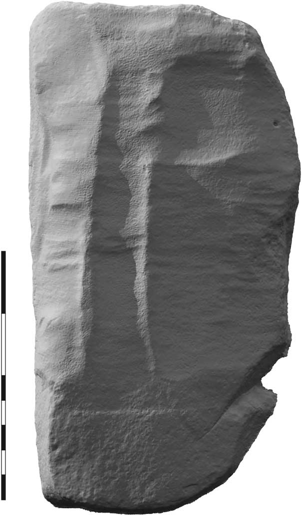
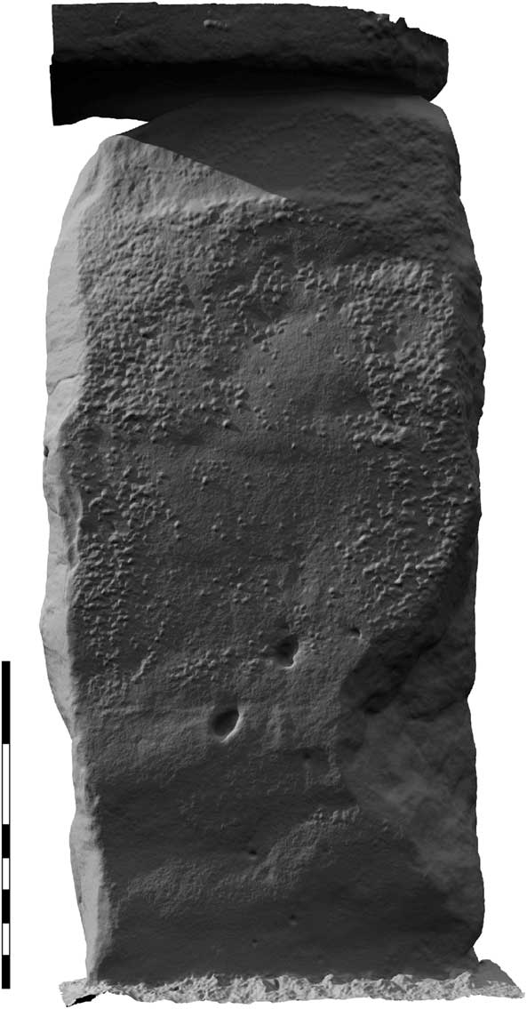
The sarsen Trilithons are the most extensively dressed and shaped of all the stones. A uniform surface has not, however, been achieved and in many cases earlier traces of working are visible through the final surface finish. No traces of shaping by splitting or large-scale flaking survive but, in any case, evidence for these techniques is likely to have been removed by subsequent dressing. The overall shaping of the stones appears to have been achieved using coarse pecking in broad longitudinal ridges (Stone Reference Stone1924, 87–8) c. 200–300 mm wide and c. 50–75 mm deep. This technique was observed on Stones 52, 53, 54, 58, and 59. Except for Stone 59 (Fig. 3), these ridges were subsequently reduced, or entirely removed, using fine transverse dressing leaving lens-shaped marks c. 50–100 m wide by c. 200–300 mm long and c. 50–200 mm deep that run at 90° to the long axis of the stones. A comparable fine tooling technique, but with marks set longitudinally to the stone, was also observed on the sides of Stones 51, 52, 53, 59, and 60. The finish, which overlay all surfaces left small ‘peck marks’ produced by pounding with small hammerstones. In several places pecking was applied in sub-rectangular panels that possibly define individual working areas, eg, Stones 54, 57, 59, and 60; the area of Stone 57 has previously been considered as a prehistoric carving possibly of a Breton-style ‘box-goddess’ (Atkinson Reference Atkinson1956, 32), but the presence of further lines revealed this to be stone-working (Fig. 4).
Stonehenge: rendered laser scan of Stone 59a, ie, the bottom portion of the stone, currently lying prone and showing areas of working within panels defined by three longitudinal ridges. The ridge to the right has been partly reduced by transverse pecking and preliminary attempts to reduce the left hand ridge can be seen in some places. A separate work panel is visible in the upper part of the scan that has completely reduced remnants of the left hand ridge, as well as partially removing the central ridge. A transverse groove that would appear to mark approximate ground level when the stone was erect separates upper and lower zones of dressing. The base of the stone, ie, below the line, exhibits a very coarse pick finish that contrasts with the fine pecking that overlies the broad ridges on the above ground portion of the stone. The very coarse dressing was only observed on areas of the monument that would have not been seen once the monument was complete (eg, stone bases, concealed areas of lintels. Scale 2 m. © English Heritage

Stonehenge: laser scan of Stone 57 with part of its lintel, showing sub-rectangular panel of working (centre left) formerly thought to be a prehistoric carving. Scale 2 m. © English Heritage

The most extensively worked, flat, regular faces on the Trilithons, are the inner surfaces, ie, those orientated towards the centre of the monument, and the external faces and inner sides of the Great Trilithon (Stones 55 and 56). This indicates that while the Trilithons, Stones 51–2, 53–4, 57–8, and 59–60, were best viewed from the interior, the Great Trilithon was best viewed from the exterior. The other sides and especially the exterior faces are typically less worked, but while these surfaces have been expressed as unfinished in the past, considerably more effort has been expended on creating these surfaces than some others in the monument, eg, the interior/exterior surfaces of the Sarsen Circle.
The stones of the Sarsen Circle are dressed using subtly different techniques to the sarsen Trilithons and bluestones; for example, the use of flaking to shape the stones and application of fine longitudinal tooling as opposed to fine transverse tooling and, overall, they are less extensively dressed. Three have been split, probably using methods similar to those employed to break up sarsens at Avebury during historic times. In addition, both large and small-scale flaking was employed as methods of reducing and shaping stones. The presence of a large sub-conchoidal flake scar on the outer face of Stone 3 indicates that this approach was used at an early stage of stone reduction. Such flaking may also have been employed to dress the base of Stone 30, which appears to exhibit flake scars exceeding 1 m in length (Pitts Reference Pitts2001, 216). Six sides and one exterior face, for example Stone 6, have been worked by small-scale flaking, and other examples may have been removed by later dressing. The dressing of the interior and exterior faces was essentially limited to pecking over the natural surface. In effect, this removed the exterior crust and revealed the white interior. The only exceptions are the inner faces of Stones 10, 22, and 28 and the exterior of Stones 10, 11, 28, and 30, where limited areas have been dressed slightly flatter than the original surface. In all cases, any trace of the earlier mode of tooling was removed by the fine pecking, with the exception of the inner face of Stone 22 which exhibits faint traces of fine longitudinal tooling beneath the pecked finish.
In contrast to the faces, the sides of the stones in the Sarsen Circle are typically extensively dressed and this serves to create the regular rectangular and trapezoidal stone forms. They were finely finished by pecking, for example, on the sides of Stones 2 and 3 and in many cases this has removed all traces of earlier tooling techniques. There is, however, limited evidence that the sides of these stones were initially shaped by splitting and/or flaking, activities that would have produced significant quantities of sarsen waste. The sides of several stones exhibit slight traces of fine longitudinal tooling, but notably the fine transverse tooling present on the Trilithons is absent.
The bluestones
All of the extant stones in the Bluestone Horseshoe and three in the Bluestone Circle (Stones 150, 36, and 45) have been finely dressed. However, scars resulting from the removal of tenons from the tops of Stones 67, 69, 70, and 72, and the repositioning of Lintels 150 and 36 as uprights, indicate that these stones have been reused from an earlier bluestone structure, probably once located in the Q and R Holes, though possibly elsewhere. The pattern of stone-working considered below therefore relates to an earlier structure.
The dressed spotted/unspotted dolerite bluestones, Stone numbers 36, 45, 61, 62, 63, 66, 67, 68, 69, 70, 71/72, and 150, were worked using the same techniques as the sarsen Trilithons, raising the possibility that these structural elements are contemporaneous. They did not exhibit the preliminary stages of dressing (eg, flaking, splitting, or coarse tooling in longitudinal ridges), evidence of which may have been removed by subsequent dressing, but it should be noted that the dolerite occurs in regular natural joint blocks of similar outline form to the final stones which, therefore, perhaps precluded the need for extensive shaping. The first stage of dressing identified was fine transverse tooling (Stones 61, 62, 63, 67, 69, 70, and 72) or coarse pecking (Stone 45). This was subsequently overlain by fine pecking, achieving regular surfaces and a very fine surface finish. Particular effort was focused on creating regular parallel sides. In most cases the fine pecking removed virtually all traces of the transverse tooling, but on Stones 45, 67, 69, 70, and 72 one broad face (now exterior face for the stones in the Bluestone Horseshoe) was left at the earlier stage of dressing.
The shape of the seat on Lintel 36 and its pattern of frictional wear can be used to further contribute to the reconstruction of the earlier bluestone structure as these marks suggest that the broad faces of the uprights and the lintel were parallel and probably erected facing the centre of the monument rather than straddling the Q and R Holes. Any other orientation would result in the rough dressing being visible from the centre of the monument (also see Darvill et al. Reference Darvill, Marshall, Parker Pearson and Wainwright2012, 1030). The available lintels support this view; Lintel 36 is 1.83 m long, with a centre-to-centre gap between the mortises of c. 0.85 m, while Lintel 150, although much longer at c. 2.44 m, has similarly arranged mortise holes at c. 1.04 m centre to centre. It is difficult to envisage how, if arranged as trilithons, they would have fitted into the Q and R Hole arrangement as very few holes are located close enough together to contain the respective uprights. Unless they derive from another monument entirely, the only conceivable position for these trilithons would be astride the north-east to south-west axis of the monument.
Stones 66 (a buried stump) and 68 exhibit ‘tongue and groove’ joints and the latter is finely pecked on all surfaces and, judging from photographs taken by R. S. Newall when he excavated the stone in 1950, the same appears true for Stone 66. It is unclear how these stones may have been positioned in the Q and R Hole structure, but it should be noted that they do not fit together as a pair and the fine dressing may indicate that all sides were meant to be visible.
Restoration: Hawley and The Stones
The settings visible today incorporate the resetting of stones in 1901 (Gowland Reference Gowland1902), 1919–20 (Hawley Reference Hawley1921; Reference Hawley1922) and 1958–64 (Atkinson Reference Atkinson1979; Lawson Reference Lawson1995, 345–6) and while every care was taken to ensure accuracy, for the precision utilised in modern astronomical sight lines relies in great part upon the positional integrity of the stones, the parameters were set by prior assumptions that the stones were originally perpendicular and that excavation would yield unequivocal proof of their original positions. Cecil Chubb’s decision to gift Stonehenge to the ‘nation’, ie, the Office of Works, in the autumn of 1918 finally permitted Charles Peers, Chief Inspector of Ancient Monuments, to set in motion a programme of Office of Works-led ‘reparation’ together with excavations by the Society of Antiquaries under the direction of Lt Col. William Hawley. The stones that collapsed in 1797 and 1900, Stones 57, 58, 158, and 22 and 122 (Fig. 2), respectively, would be re-erected and all leaning stones drawn back to what was assumed to be an original vertical position. Where necessary, as in 1901 for the straightening of Stone 56 (Fig. 2: Blow Reference Blow1902; Gowland Reference Gowland1902), the bases of the stones would be set in concrete (see Barber 2014).
Concerns over the stability of some of the stones – as opposed to a desire to re-erect fallen sarsens – had first come to the fore in the 1870s. In addition to the 1797 and 1900 collapses, the principal targets in 1919 were Stones 6 and 7 on the eastern side of the sarsen circle (Fig. 2) plus their lintel; and the north-east-facing Stones 30 and 1 and their lintels. Eventually, only this last group, with 6 and 7, were dealt with. In each case the lintels were known to have fallen in modern times, being depicted, for example, by Stukeley (Reference Stukeley1740) as in position.
Problems began with the first efforts at stone-straightening, for the laser scan quite clearly shows that Stone 56, reset by Gowland (Reference Gowland1902) is now skew from the north-east to south-west axis of the monument, something also observed by Johnson (Reference Johnson2008, 240). With one stone leaning inwards and the other outwards, Stones 6 and 7 had long attracted attention; their twisted appearance had led to concerns about stability. Peers’ assumption was that when the stones were lifted and the stone-holes excavated, there would be clear indications in the chalk as to where the stones should stand. However, on 28 January 1920, it was reported that ‘the evidence obtained in the foundations of the No. 7 stone is not sufficient to determine its original position’ (memo written by Arthur Heasman, Office of Works, 28 January 1920, in TNA WORK 14/485). The same applied to its neighbour – ‘there was obviously nothing in the original excavated holes which would shew the correct positions of the stones’ (memo by Arthur Heasman, 18 February 1920, in TNA Work 14/485). In addition, Peers ‘also pointed out that there was no evidence which could be brought forward to show the original height of the stones above ground. It was a matter of judgment …’ (ibid.). Consideration was given to identifying a line of best fit from Petrie’s survey, but ultimately the position and height of the stones was selected by Hawley. ‘Careful plumbings’ were also taken to ensure that 6 and 7 were as vertical as possible before the concrete (which was reinforced with steel rods) was poured in to the stone-holes (ibid.).
Further complications surrounded the replacing of the lintel, and the concrete support to Stone 6. For the lintel, there were concerns that it ‘would not have an even bearing on the stones owing to the fact that the stone had weathered very irregularly. It was therefore advisable to place some form of cap on the top of the stone around both the mortise and tenon, which would give an even bearing’ (ibid.). After considering bronze and aluminium, it was decided to use a lead capping to secure the lintel in place, with a recommendation that ‘some of the old lead from Hampton Court should be used for the caps as it was of very good quality and rather harder than modern lead’ (ibid.). However, Peers intervened to prevent use of lead on other lintels, arguing that ‘When it is realized that, after 3000 years, the tenons still preserve the original tooling, & that the tops of the upright stones cannot have lost more than the merest fraction of an inch from weathering, any such precautions as are proposed will be seen to be superfluous’ (memo, Charles Peers, 16 July 1920, in TNA WORK 14/485).
As for the base, specific concerns were raised that the procedure used to stabilise Stone 7 in place might not be sufficient for Stone 6. In keeping with the general approach employed by the Office of Works at the time, it was intended that any repair or restoration leave no visible trace. Consequently, the concrete had to remain hidden from the sight of visitors. With Stone 7, the concrete had been poured to a level 6 inches (152 mm) below the ground surface before being covered with soil and capped with turf. However, after a site visit, Arthur Heasman reported that ‘after inspecting the concrete that was being laid round the No. 6 stone I decided that it would be better to bring it up to general ground level instead of keeping it 6” [152 mm] below ground as had previously been decided. I am afraid if the concrete is kept down to the lower level it will not give a sufficient grip of the toe of the stone which, as you will remember, is very pointed’. He continued ‘If the concrete is too high it can be chipped off at a later date, but I think you will agree that we ought to have a perfectly sound job to prevent any possibility of the stone over-turning. I also think that you will find later that you can raise the general ground level around No. 6 stone by about 6” without affecting the appearance of the Circle, this will enable the grass to grow over the concrete’ (memo, Arthur Heasman, 26 March 1920, in TNA WORK 14/484).
Peers’ response was to reject the idea: ‘I should certainly be glad to avoid this if possible: the surface of the concrete will be a great disfigurement: & anything in the nature of levelling of the uneven ground round the stones must be avoided. Even if we could postulate an original surface level, we should not be justified in replacing it’. The concrete was laid as originally planned ‘except close around the stones where it has been brought to within 6” or 3” [76 mm] of ground level. The turf which has now been laid completely covers the concrete bed’ (memo, Charles Peers, 25 March 1920, in TNA WORK 14/485).
Moving on to other stones of the sarsen circuit was more complicated. Stones 6 and 7 plus their lintel comprised an isolated group. 29, 30, 1, and 2 comprised four standing stones connected by three lintels. Less detail is available for these operations, presumably because many of the potential problems had already been solved in dealing with 6 and 7. However, this time the straightening of any individual stone had a knock-on effect with regard to the positioning of the others. As before, there was much use of plumb bobs to ensure the uprights were as vertical as possible. The lintels were removed, and castings taken to allow the manufacture of dummy lintels. The positions of individual stones, now vertical, then had to be re-adjusted in order to ensure that the dummy lintels would fit. Only then could the real lintels be hoisted back into position. However, this proved to be far from straightforward, and even after concrete had been poured in to some of the stone-holes, adjustments continued to try and ensure (a) verticality and (b) a secure fit for the lintels. Stone 2, meanwhile, was deemed not to need straightening, but ultimately a decision was taken to set it in concrete ‘in order to obtain uniformity of bearing on the soil’ (memo, Arthur Heasman, 3 September 1920, in TNA WORK 14/485). Its lintel, 102, with its south-east end touching the tenon for the missing lintel 103, however, is clearly incorrect and may be an indication that the monument was not constructed in prehistory with perfect geometric precision.
As in Atkinson’s later restoration work (Lawson Reference Lawson1995), in each case the work was carried out in order to make the stones safe but, as in all such situations, the process of making good will have obscured archaeological data and rigidly established a modern assumption of form. Thirteen of the 17 sarsens presently standing in the outer circuit and six of the ten Trilithon uprights have been subject to some form of intervention and the cases outlined above indicate just how subjective some of the work can be. The 1970’s reconstruction of Newgrange, for example, has recently been observed as problematic (eg, Eriksen Reference Eriksen2008, 271) and it is conceivable that in time questions relating to whether lintels were fitted to stones that were originally leaning in antiquity may be asked here.
Interpretation of the Sarsen Settings
Many of the stones in the southern part of the setting are now fallen or are missing, but there are other irregularities and the location of the chalk mound in the south-east reported in Part 1 of this paper (Field et al. Reference Field, Linford, Anderson-Whymark, Barber, Bowden, Linford and Topping2014) serves to encourage a greater focus on these. Indeed the various components of the present survey help contribute to, although do not fully resolve, the fundamental issue of whether the sarsen settings ever formed a ‘complete’ circle, attention to which was drawn by Cleal et al. (Reference Cleal, Walker and Montague1995, 205–6), subsequently Ashbee (Reference Ashbee1998), and more recently signposted by Tilley et al. (Reference Tilley, Richards, Bennett and Field2007, 199–201).
This is not simply a question of whether the stones formed a circuit but whether they match the neat template provided in Inigo Jones’ reconstruction drawing. The Jones reconstruction was supported by ideas that the monument had been quarried for stone to greater or lesser extents and in particular that it may have been vandalised during the Roman period and material removed (R. H. Cunnington Reference Cunnington1935, 130). Despite almost universal agreement by surveyors and field workers, Wood (Reference Wood1747), Smith (Reference Smith1771), Petrie (Reference Petrie1880), Stone (Reference Stone1924), and others, who pointed to significant difficulties with the Jones vision, the image has prevailed in both academic (eg, Castleden Reference Castleden1987, 150) and popular perceptions (eg, Heath Reference Heath2000, 21; Freeman Reference Freeman2012, 105) largely inspired by previous English Heritage brochures and publications (eg, English Heritage 1995; Richards Reference Richards1991, 127) and not least as presented to millions of visitors in the reconstruction by Ivan Lapper on the former site underpass from the carpark to the stone circle. Gowland and Hawley, both major excavators of the site, mainly avoided the issue, while Atkinson acknowledged the difficulties with the completed stone circle hypothesis on several occasions. Following the excavations and reconstructions of the 1950s and 1960s, Ashbee (Reference Ashbee1998) probably went furthest to explain and account for the problems, noting that the stones facing the Avenue, Stones 29, 30, and 1–7 are the standard since they match and are the ones retaining lintels; as such they would have been the ‘planned norm’ and were the template on which the Jones reconstruction was based. In the absence of ‘missing’ stones, Ashbee invoked the use of wooden uprights and lintels in order to account for a complete circuit. This idea of mixing materials may seem strange from a modern western architectural perspective but undoubtedly Stonehenge need not have conformed to the Jones reconstruction and, in view of the unexpected feature of an upturned tree-bole at Seahenge, for instance (Pryor Reference Pryor2008), the Ashbee suggestion may have merit. Wooden lintels would certainly make some sense, especially as models for the sarsen ones, for Hawley used lighter castings to ensure they got the fit right before hauling the sarsen lintels up. If some were never replaced in stone, it might also explain why so many are now missing.
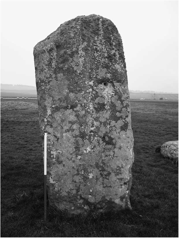
There are several aspects to this argument worth reconsidering: missing stones; the use of irregular stones; and the absence of lintels. Today, only 17 of a presumed 30 upright stones representing an outer circle are in position and a further eight are prone or in fragments. Five are missing completely, although they were speculatively numbered by Petrie (Stones 13, 17, 18, 20, and 24). Also absent are 22 of 30 predicted lintels; six (Lintels 101, 102, 105, 107, 122, and 130) survive in place and two (Lintels 120 and 127) are represented by fragments on the ground. There is a further point noted by several writers (Petrie Reference Petrie1880; Stone Reference Stone1924; Tilley et al. Reference Tilley, Richards, Bennett and Field2007), notably the irregular or diminutive size of some stones and in particular Stone 11 (Fig. 5). None of these observations is of great significance in itself as such irregularity is not entirely unknown in stone circles elsewhere but, given the views of Ashbee and others, cumulatively they demand some attention.
Stonehenge: diminutive Stone 11

Missing stones
The problem of missing Stones 13, 17, 18, and 24 might, at least in part, be addressed by the presence of tenons on the adjacent uprights since, unless they were made to a template and their survival thus fortuitous, there is an assumption that they were made to support lintels that rested on the missing stone. The photogrammetric data confirms the presence of tenons, or vestiges of them on Stone 3 (where they lie within a reduced oval rebate) and on Stones 10, 16, 23, 27, and 28, while field examination reveals traces on fallen Stones 12 and 14 as well as the fragmentary Stone 19, all of which provide evidence of an intention to set the stones to a common height and to surmount them with lintels. Thus the presence of tenons on Stone 16 can also be used to argue for the intention to provide neighbouring uprights 15 and 17. What is considered to be the broken top part of Stone 15 (its lower two-thirds now missing), has a tenon at the damaged upper edge close to the base of Stone 55 in a position where it might have fallen naturally. More speculatively, it could be argued that the existence of Stone-hole 20, excavated by Richard Atkinson in 1958 (Cleal et al. Reference Cleal, Walker and Montague1995, 197) implies that an upright was once present within it and mantled by Lintel 120, although there is no evidence that the latter was ever raised and, in fact, no evidence that an upright was ever present. Under similar rigorous analysis, the summit of Stone 16 can be observed as particularly narrow and one of the tenons is unusual, being oval and, not yet shaped to match its mortise, appears unfinished; consequently it may not have secured a lintel (see also Tilley et al. Reference Tilley, Richards, Bennett and Field2007, 200–1).
Irregular stones
Departure from Ashbee’s ‘planned norm’ is frequent in the south-western part of the circle. In particular, Stone 12 is irregular and 14 completely asymmetrical, while Stone 16, although exceedingly finely shaped and regular when viewed externally from the south-west, is almost twice the width at the base as the norm, tapering to a chisel edge top just 0.7 m wide. Stone 21 is, as pointed out by Petrie (Reference Petrie1880, 16) small in stature in both width and breadth Additionally, at just half the width and three-quarters the breadth of others, Stone 11 is the most irregular stone remaining upright and indeed Petrie used it as the basis of his ‘unfinished’ hypothesis. It currently stands 2.7 m in height (Fig. 5), but would be expected to have formerly reached the same height as the others and, with its buried portion taken into account, it must have presented an unusually long, thin, rod-like stone some 5 m in length. It would be unusual for such a tall thin pillar to occur naturally although it could conceivably have been split from an asymmetrical or otherwise irregular stone. Given its slender dimensions it could have broken under the weight of a lintel at some point in the past as assumed by Lukis (Reference Lukis1882), Atkinson (Reference Atkinson1956) and others, but the laser scan reveals that its top provides no evidence of such fracture and even if it were so, its upper portion is missing (as is a lintel) and there is no evidence in the GPR data of it being buried alongside. The rounded nature of its upper surface, however, which is beyond the normal reach of souvenir hunters, is curious and could have been deliberately contrived during prehistory. The position of the stone is unusually skewed from the curve of the rest of the circuit and it is quite possible that, like Stone 13, it was reset in position or had been affected by the collapse of an adjacent stone. Indeed, while it is dressed to some extent all over, Parker Pearson (Reference Parker Pearson2012, 252) recently pointed out that the inner face did not receive the same treatment as others, and suggested that it had been moved from one of the Station Stone holes or from the stone-holes that occur adjacent to the Slaughter Stone (Wiltshire Museum; Cunnington letters; Cleal et al. Reference Cleal, Walker and Montague1995, 283–7). If this were so, it would imply that at least two of the sarsens in the circuit were moved or reset in antiquity, for Hawley implied as much for Stone 13. Alternatively, if this stone had been broken during the initial construction this would have neutralised its structural integrity as part of an original Neolithic circle and it could have been replaced immediately with a complete, full-sized stone. If, however, it was erected in this form, or re-erected subsequently, either during the Neolithic or a later period, it introduces a note of caution, as other stones in the settings may have been similarly treated. Stone-hole 13, mentioned above, could also have originally held a rod-like stone or, like its partner Stone 14, one of asymmetrical form with its smaller end set in the ground. The stone-hole is a quarter of the size of some of those in the north-eastern part of the setting and the stake-holes set for guiding the stone into position indicate that it is likely to have been rather smaller than the diminutive Stone 11 (Cleal et al. Reference Cleal, Walker and Montague1995, fig. 99 and plan 1). Hawley believed that an even smaller stone may have been reset here although there was no second group of guiding stake-holes.
Lintels
Certain irregularities occur among the lintels, for example, the laser scan data make it clear that Lintels 105 and 122 have tongue joints at both ends, while tongue and groove joints on the end of some (eg, Lintel 107 south-west end) were prepared inaccurately and would not grip securely. Given the diminutive tenons on Stone 14 (one placed centrally, the other on an edge) it is difficult to imagine how its lintel would have been fixed in place. Certainly the probably unfinished elongated oval tenon present on the north-west side of Stone 16 is anomalous, ie, the ridge would be reduced to a circular tenon once the precise location of the mortise had been determined. This lintel at least, may not have been set in place, while irregularity in the case of others draws into question the structural integrity of this element of the monument. The excessive overlap of Lintel 102 is visible on photographs taken before the restoration (eg, James Reference James1867, 11) and the problem has been highlighted above. Such inconsistencies and structural defects might also help to explain why some settings actually collapsed. Given these irregularities, there is some indication that construction was not necessarily consistent or systematic and that not all lintels were constructed in the same manner.
Atkinson (Reference Atkinson1979, 208) maintained that in order to achieve an accurate alignment the mortises were prepared first. He based this interpretation on the examination of Lintel 122 that exhibits two pairs of mortise holes, suggesting that they had been re-adjusted to align with the tenon of Stone 21. However, Stone 21 is one of the unusual narrow uprights identified by Petrie and the only one which appears to have been erected from inside the sarsen circuit and is, therefore, anomalous (Atkinson Reference Atkinson1979, 207; Cleal et al. Reference Cleal, Walker and Montague1995, 197). To fit, the standard mortise would have had to be positioned differently to the others. That it was not and had to be recut indicates that it was not initially prepared for this upright, and could even imply that mortised lintels were prepared separately from the uprights.
Whether or not the link can be made, it could be misleading to assume that the mere presence of tenons means that lintels were assembled. Wood (Reference Wood1747, 61) implied as much when he questioned why Lintels 103, 104, and 106 were missing when they should have been securely locked into adjacent stones, and Atkinson (Reference Atkinson1979, 38) could only posit the unlikely scenario that they could have been dismantled by medieval masons. There are several other inconsistencies concerning the lintels. If Stone 11 did indeed originally stand to its full height and support a lintel, the span to the adjacent stone would be longer than the norm. Tenons on the upright would need to be set close to each other, closer to the edge and would allow for little error in the mortise (cf. the recutting of the mortise on Lintel 122). Nevertheless, smaller seats may be no less deficient and Johnson (Reference Johnson2008, 146) has argued that, in the case of Stone 11, a thin stone could equally have supported a lintel as a regular sized one. However, lintels surviving in position on, for example, Stones 2, 6, and 29, all overlap and rest on their respective uprights by c. 1 m, which presumably provides stability and spreads the load. Consequently, if there was originally a sequence of narrow uprights forming the south-west sector which retained the spacing estimated by Petrie and others, the spaces between the vertical stones would be wider and the lintels would have had to be longer to match.
Missing stone-holes
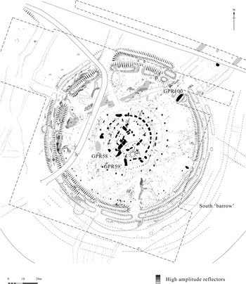
Although not critical to the argument presented by Ashbee and others, additional perspective can be introduced by considering whether stone-holes existed for missing Stones 13, 17, 18, 20, and 24. Certainly, the presence of Stone 13 might be assumed by the existence of its stone-hole (Hawley Reference Hawley1926, 10–11) but, until recently, the existence of other stone-holes remained unknown. Payne (Reference Payne1995, 505) reported that no geophysical signature was evident in the magnetic and earth resistance data from several of the expected stone-holes of the sarsen circle, ie, Stone-holes 15, 17, 18, and 19. Consequently, these areas were targeted with GPR and, except in the case of Stone-hole 18, this technique also failed to locate evidence for stone-holes. Additionally, there was no clear response where Stone-hole 24 might be expected. It is conceivable that, in some cases, signals could have been obscured by the presence of the geophone array inserted in 1968 (Cleal et al. Reference Cleal, Walker and Montague1995, 12, fig. 289) which would bisect the positions of Stones 17 and 18 and, certainly, two of the more prominent Z Holes identified as substantial low-resistance anomalies in this area are not replicated in the GPR data (cf Fig. 6 and Payne Reference Payne1995, fig. 262, anomalies 10 and 11). Rigorous analysis of the geophysical data, however, revealed that while other known excavated pits and holes were represented, neither resistivity nor GPR revealed the position of the excavated Stone-hole 13 (Hawley Reference Hawley1926) which suggested the need for some caution when reviewing the data. Aside from its small size Stone-hole 13 had received different treatment, being backfilled in antiquity with a 0.3 m thick layer of ‘large flints mixed with chalk which had been rammed hard to form a solid mass’ (Hawley Reference Hawley1926) and it is possible that this is a factor that influenced the lack of geophysical signature. If so, it might be argued that similar small stone-holes given such treatment may similarly have escaped being recorded. More certainty was provided, however, when parch-marks were recorded during the summer of 2013 (Banton et al. Reference Banton, Bowden, Daw, Grady and Soutar2014) in the expected position of Stone-holes 15, 17, and 18, which indicates that stone-holes are indeed almost certainly present. Given their size, it is quite conceivable that, if present, any stones that they held were small in stature, diminutive or asymmetrical.
Stonehenge: graphical summary of significant anomalies detected by Ground Penetrating Radar. © English Heritage

The Nature of the Circuit
Whether there was originally a setting of 30 stones, or more, in the outer circuit remains uncertain, but there is demonstrable evidence of one kind or another for the presence of 27 of an expected 30 uprights along with the existence of stone-holes that, if set with stones, would complete a circuit. That an attempt appears to have been made to set the uprights so that they reached a common height, coupled with the presence of tenons on a good number, implies that there was an intention to provide lintels for most of the circuit even if they did not all eventually materialise. Why the lintels should be set at a height of 4 m is not completely clear when they could more easily have been positioned at a lower level which would have allowed the uprights to be set more securely as well as making it easier to position the lintels (cf, Wiltshire Reference Wiltshire2012). However, perhaps greater height was thought not only to be more imposing, but to have increased the visibility of the monument, although its chosen landscape location is not exactly prominent. There is, of course, no documentary or other evidence for the dismantling of lintels (Tilley et al. Reference Tilley, Richards, Bennett and Field2007, 201) and, if ever present, it is difficult to ascertain why so many are missing. Certainly, some lintels do not appear to have been fixed securely and could have fallen, but others will have been more secure. It may be that few were fully assembled and, if left lying on the ground, would be the easiest of all the stones to remove. Whatever stone removal occurred, it was not systematic and indeed appears to have been rather ad hoc as many of the smaller and easier to remove stones were ignored. The upper portion of Stone 15, for example, with its neatly dressed seat, appears to lie where it fell, while its lower portion is missing. The question of stone removal has been discussed elsewhere (Lawson Reference Lawson1995 and refs therein; Long Reference Long1876; Petrie Reference Petrie1880; Abbott & Anderson-Whymark Reference Abbott and Anderson-Whymark2012; Field & Pearson Reference Field and Pearson2010) and it is noteworthy that inspection of buildings within the WHS as part of this survey (Lane Reference Lane2011) did not reveal any sarsen. Unlike Avebury, and aside from indicating that sarsen removal must have taken place before 1621 when Inigo Jones surveyed the site (Jones Reference Jones1655, 63), it could have occurred at any time in the past. Indeed it could have occurred while the monument was in use (Cleal et al. Reference Cleal, Walker and Montague1995, 205). Breakage of sarsen for incorporation in cairns beneath long barrows, for example, at Knook on Salisbury Plain (Eagles & Field Reference Eagles and Field2004, 59), may have been part of a local prehistoric tradition with echoes of practices involving the destruction of standing stones for incorporation in tombs in Brittany (Bradley Reference Bradley2002, 34–41). Given the ritual fracturing of flint axes (Larssen Reference Larssen2011), the suggested breakage of bluestone for curative purposes (Darvill & Wainwright Reference Darvill and Wainwright2009) and, not least, the presence of stone in the matrix of the nearby Bronze Age round barrows (Field et al. Reference Field, Linford, Anderson-Whymark, Barber, Bowden, Linford and Topping2014), the possibility of selective rearranging, reworking, removal, or destruction of sarsen in the later Neolithic or Early Bronze Age as part of the ritual here should not be excluded and is a distinct possibility.
The different levels of survival of the north-east and south-west arcs of the monument require some comment. The fallen and fragmentary nature of stones in the south-west sector has been put down to the effect of the prevailing wind (Atkinson Reference Atkinson1957, 2), yet Stone 16, for example, stands proud with little or no weathering and as Tilley et al. (Reference Tilley, Richards, Bennett and Field2007, 200) observe, is more menhir-like in appearance than the others. In addition, weathering occurs in the east in equal measure, and there is even some disparity between the weathered surfaces of adjacent stones. It seems likely that lack of weathering merely reflects the resilience of the siliceous source material of individual stones. Instead, it is worth questioning whether the pattern of fallen stones results from differences in construction. It is certainly clear that the asymmetrical and smaller stones have been used in the south-west part of the circuit and, in the case of Stone 13 at least, this had been extracted or perhaps replaced while the monument was in use – a scenario which may have been repeated. In some degree it might be taken to be the result of less conscientious construction, or even that the south-west arc was hurriedly completed. The fundamental differences between north-east and south-west sectors therefore not only extend to the choice of stone used, but also the construction technique employed within the settings. The sector defined by Stones 11–21 is certainly less substantial and the irregularity of the stones in this south-western arc has been seen as evidence that large rectangular slabs to complete Ashbee’s ‘planned norm’ were no longer available. Like Petrie (Reference Petrie1880), E. H. Stone (Reference Stone1924, 5, 73) commented that an ‘examination of the stones at Stonehenge would appear to show that the builders were unable to obtain sufficient material of suitable quality and of large enough size to properly fulfil their requirements’, while Atkinson could only conclude that the builders ‘were hard put to find sufficient blocks of the requisite size to complete the circle’ (Atkinson Reference Atkinson1979, 38).
Implicit in this is that the north-east sector was constructed first and the south-west built almost as an afterthought, or at least added subsequently. This would be no surprise given that it faces the Avenue and the midsummer solar alignment. Unfortunately the dating of the stone settings is poor, only a single reliable radiocarbon date is available for the sarsen circuit (Cleal et al. Reference Cleal, Walker and Montague1995, 521–6), thus it is impossible to determine with any real precision whether construction was spread over a few years, decades, or even centuries. The implied desire for a lintel-led circuit does, however, suggest the pre-existence of an overarching construction concept that was then passed down to the teams of builders perhaps over the span of generation or longer. It could explain why some uprights had tenons but not lintels if an adjacent upright remained to be erected. Consideration of these observations might help to unravel the process by which the lintelled sarsen circuit was brought to fruition. While it is generally accepted that the bluestone settings metamorphosed between different arrangements, such possibilities for the sarsen setting have rarely received consideration. Given the potential reuse of Stone-hole 13 and possibly Stone-hole 11, it is quite possible that many of the stones are derived from earlier arrangements and, in this respect, it is worth bearing in mind that a second stone-hole exists beside the Heelstone (Pitts Reference Pitts1982). Another, or perhaps two, lies beside the Slaughter Stone (Cleal et al. Reference Cleal, Walker and Montague1995, 283–7; Wiltshire Museum Cunnington letters), while Atkinson (Reference Atkinson1979, 211–2) referred to a pair behind the Altar Stone, all of which demonstrate the active removal and perhaps repositioning of certain stones. A stone-hole sized parch-mark on the summit of the mound recorded by Tim Daw in 2013 (pers. comm.) could also indicate an earlier setting. Certainly, whether considered as a 5 m tall rod-like stone or a round topped, stumpy version, Stone 11 presents problems and does interrupt the sequence. However, there may be some merit in the idea outlined by Edgar Barclay (Reference Barclay1895, 64) who accounted for its small size by suggesting that the lintels could have been discontinuous at this point and that it marked a previously unnoticed south entrance into the stone circuit; it is after-all aligned on the causeway through the enclosure ditch. Burl noted that pillar-like stones often occur at the entrance to stone circles and provided examples at Long Meg and Castlerigg, both in Cumbria; Ballynoe, Co. Down; Girdle Stanes, Dumfries; and Swinside, Cumbria (Burl Reference Burl1976, fig. 8), the latter two with an entrance in the south-east. Closer to Stonehenge, it is worth noting that an entrance in the south-east of the Rollright Stones is marked by portal stones (Lambrick Reference Lambrick1988, 41–2).
For the moment, the evidence that the sarsen settings formed a completed circuit remains ambiguous. Parch-marks indicate that Stone-holes 15, 17, and 18 were almost certainly present (Banton et al. Reference Banton, Bowden, Daw, Grady and Soutar2014) and a circuit therefore intended. Whether stones were erected is another matter, for Ashbee’s point remains and the situation was probably best expressed by Cleal et al. (Reference Cleal, Walker and Montague1995, 205) who suggested that the circuit may have been considered complete even if there was absence in the architecture. In this respect, the presence of tenons on stones without lintels might argue for an intention to complete a lintelled circuit even if it was not achieved. Whether or not this was the case, it is clear that the perfect lintelled circle as envisaged by Inigo Jones and others was probably not achieved, for the survey indicates that there were significant differences between the north-east arc facing the Avenue and the south-west arc and supports the observations of Tilley et al. (Reference Tilley, Richards, Bennett and Field2007). In this respect the former represents a façade rather than characterising a circuit. It is notable that the largest, most regular, and finest worked stones are positioned in the north-east where they face the mid-summer rising sun and the approach from the Avenue. Techniques are not currently available to detect whether this façade was painted or whitewashed to enhance its visual impact, but freshly removed crust revealing the sparkly sandstone may have ensured that it glistened in the sunlight. Taken together, there is little evidence to support the notion of a circle completed to a ‘planned norm’. Instead, like many chambered tombs, there appears to have been a conspicuous façade which was given a considerable degree of structural prominence (Tilley 2007, 200–1). Elsewhere there is irregularity and variability, but it is this very uncertainty that may provide insight into the processes involved at the site.
Other Stones
Anomalies revealed by GPR surrounding fallen Bluestones 36 and 41 (Fig. 6) may be associated with excavations by Hawley and Atkinson. An arc of more discrete anomalies is found on the circuit of bluestones between Stones 41 and 42, and follows the distribution of features revealed by Atkinson in trench C52 (numbering by Cleal et al. Reference Cleal, Walker and Montague1995), including apparent responses due to the site of bluestone stumps (eg, Stone 41d). A further area of discrete response, immediately south of fallen Bluestone 43, correlates with the location of the buried Bluestone stump 42c. Other responses are more difficult to interpret as they fall within the area of previous visitor access used during the 1960–70s when the path led on to a wider gravelled surface surrounding the stones (English Heritage Archives vertical HSL/UK/65/378). However, the buried bluestone between Stones 45 and 46 does appear to have produced a GPR response.
A linear group of GPR anomalies extends north from sarsen Stone 56 towards bluestones 69, 70, and 70a. Although it does not appear to fall on the presumed circuit of the bluestone oval it may relate to a feature (WA3710) part revealed in excavation (Cleal et al. Reference Cleal, Walker and Montague1995, figs 116 & 122). However, a more subtle response appears to represent the location of a presumed bluestone setting between Stones 61 and 61a, or possibly a fallen or broken fragment of Stone 61a. Whilst other anomalies have been recorded in the central area they mainly fall within areas where excavation trenches were cut by either Hawley or Atkinson, or are closely related to either standing or semi-recumbent stones.
Given the extensive digging and probing within the central area described by Inigo Jones and various other authorities (Jones Reference Jones1655, 75–6, 100, 105; Reference Jones1725, 124; Long Reference Long1876, 237–9; Field & Pearson Reference Field and Pearson2010) it is surprising that earthworks representing these activities are not visible. Petrie (Reference Petrie1880) noted that there was no cavity or undulation in the centre of the area although the photographs taken by J. J. Cole in 1881 indicate that subtle features were present (English Heritage Archives MPBW Collection S617). Parts of the interior were covered with gravel in the 1960s (English Heritage Archives vertical HSL/UK/65/378), nevertheless, the potential of parch-marks recorded during dry summers was illustrated by Cleal et al. (Reference Cleal, Walker and Montague1995, pl. 6, fig. 290) for the position of Atkinson’s trench in the north of the interior is clearly depicted by one, while another to the north of the Altar stone could result from a combination of the Stukeley, Beamish, and Atkinson excavations. There does, however, appear to have been a process of site clearance and surface modification some time before William Cunnington and Sir Richard Hoare worked at the site in the early years of the 19th century (Field et al. Reference Field, Linford, Anderson-Whymark, Barber, Bowden, Linford and Topping2014) as the debris associated with Gaffer Hunt’s occupation of the site that obscured much of the central area during John Smith’s (Reference Smith1771) survey had been cleared away, his ‘cellar’ filled in and the North and South ‘Barrows’ altered.
Elsewhere within the enclosure the GPR identified two potentially significant anomalies to the south-west of Stones 14 and 16 respectively, situated on the course of the shallow bank between the circuit of Y and Z Holes (Fig. 6, gpr 58 & 59). These are quite complex reflectors, apparently consisting of two short parallel linear responses 1.6–2.9 m long that appear in the data at a depth of between 0.18 m and 0.78 m below the surface for the northerly, and between 0.3 m and 0.6 m for the southerly anomaly. As only limited modern intervention is known within this area – 59 is on the fringe of the area investigated by Hawley and 58 outside it completely – it is difficult to ascribe either of these immediately to a more recent origin. If they do indeed represent a response to buried individual, pairs, or fragments of stones, then their location is certainly intriguing; in particular, their position at the ‘back’ of the settings invites thoughts about alignments with other possible paired stone(-hole)s Stones 14 and 16, the Altar stone(s), Slaughter, and Heelstone(s). The similarity between these and their plausibility as the response to potential buried stones and spatial relationship to the monument certainly merits further investigation, at the very least to rule out explanation due to a more recent intervention. Two further anomalies (Fig. 6, gpr 100) occur beneath a small mound to the west of the Slaughterstone. The northernmost may mark the position of Stone-hole E, which is thought to have held a stone pillar as companion to an erect Slaughterstone (Ashbee 1994), but the southern occupies an area unexcavated by Hawley (Cleal et al. Reference Cleal, Walker and Montague1995, fig. 168) and may mark the position of an unrecorded stone-hole.
Rock Art
One of the fundamental aims of the laser scan strategy was to determine whether further carvings lay above eye level and whether carvings exist on the lintels; in particular, it was of interest whether there was any indication of Neolithic art work. In fact, no Neolithic carvings were discovered and Richard Atkinson’s (Reference Atkinson1979, 209) claim of the presence of Neolithic Passage Grave art on Stone 3 cannot be substantiated, while many other reported carvings, such as quadrilaterals, snakes, ‘torsos’ and cup-marks are no more than natural irregularities, areas of stone dressing, or the results of differential weathering.
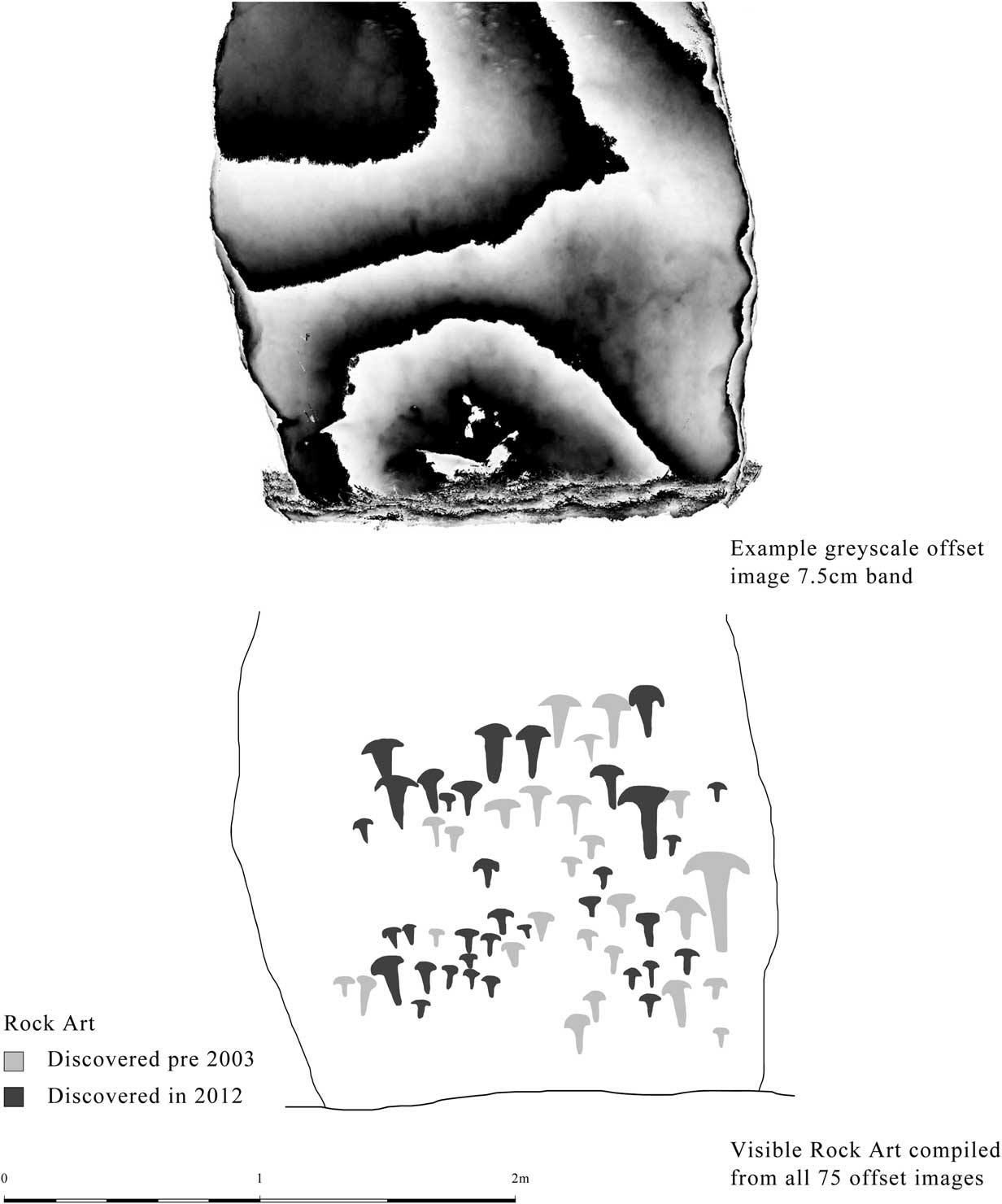
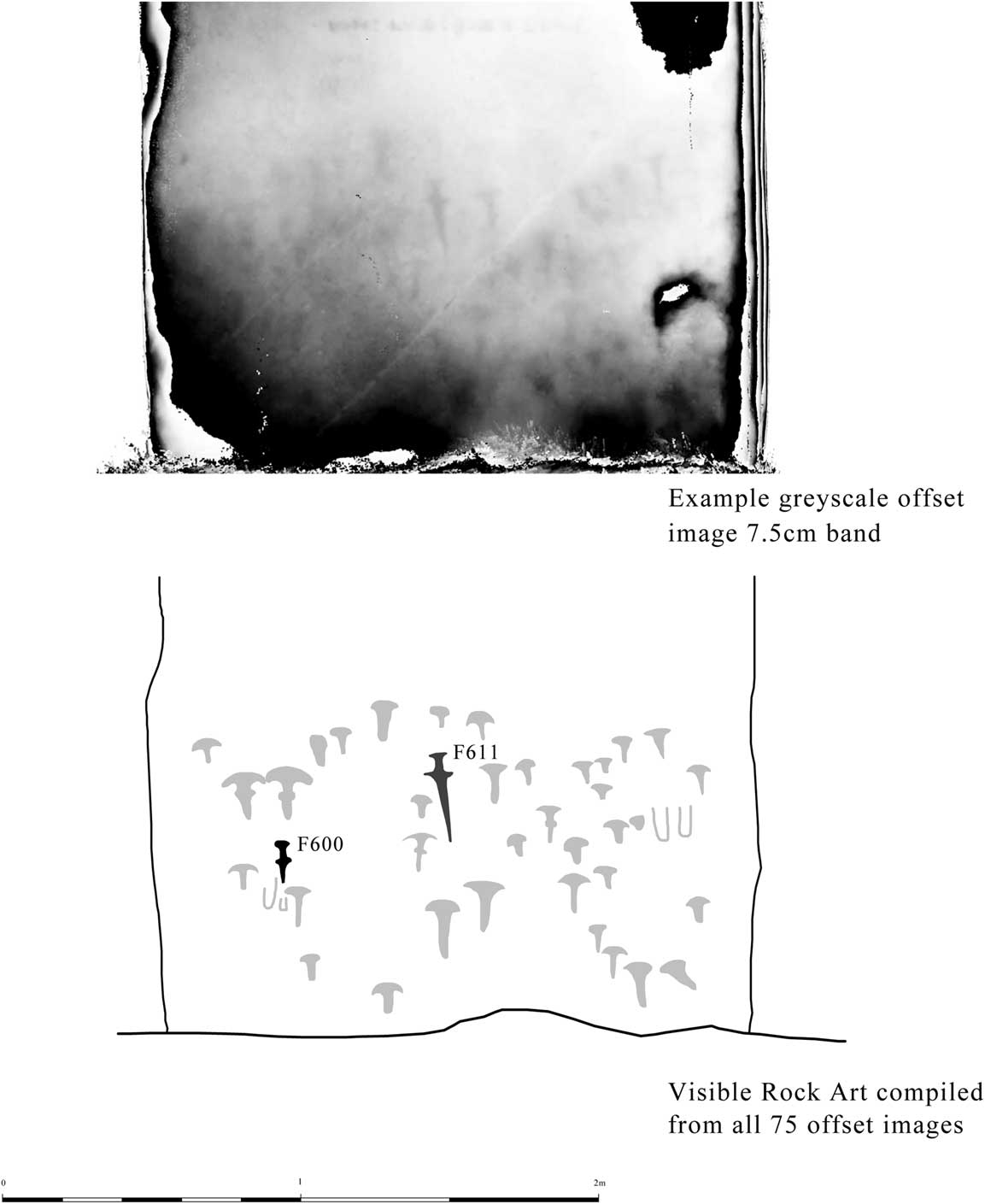
However, 71 new carvings of axe-heads and a possible dagger were revealed. The number of prehistoric axe-head carvings has thus increased from 44 to 115, which doubles the number of Early Bronze Age axe-head carvings known in Britain. Additionally there are three dagger carvings (Figs 7 & 8). These motifs occur in four key panels (the exterior east faces of Stones 3, 4, 5, and the north-west interior face of Stone 53), but four motifs are found elsewhere. The carving of one axe-head was found on the north face on Stone 5, two axe-heads formerly identified as a dagger were found on the south-west face of Stone 53, and a dagger is present on the south-west face of Stone 23. The axe-heads are readily identifiable as a form of flanged bronze axe with distinctively splayed edges that was in circulation around 1750–1500 cal bc; the dagger styles would also fit this date range (Needham Reference Needham1996, Stage 4; Needham et al. Reference Needham, Bronk Ramsey, Coombs, Cartwright and Pettitt1998; Lawson Reference Lawson2007). The stones had been standing for almost a thousand years before the first carvings were made on them.
Stonehenge: greyscale plane-shaded view of axe carvings on the east face of Stone 4 depth-shaded in 75 mm slices. © English Heritage

Stonehenge: Atkinson’s dagger (F611) and the newly discovered possible dagger (F600) on the north-west face of Stone 53. Greyscale plane-shaded view depth-shaded in 75 mm slices. © English Heritage

The axe-head carvings at Stonehenge can be paralleled at four other sites in Britain; three in the Kilmartin Valley, Scotland – Nether Largie North Cairn, Ri Curin Cairn, and a cist at Kilbride (RCHMS 2008) – and the Badbury Barrow, Dorset. Only the latter has axe-head and dagger carvings (Piggott Reference Piggott1939). A possible dagger or halberd carving exists on a stone at Calderstones, Liverpool, which once formed part of a monument (Forde-Johnston Reference Forde-Johnston1957; Nash & Stanford Reference Nash and Stanford2009). These parallels, however, have not been identified on Neolithic stone monuments; they are carved into the sides and capstones of cists within barrows. The intimate association of these carvings with burials is potentially of great significance, and one may interpret them as being part of the mortuary ceremonies associated with the dead, perhaps conveying something of the wealth and social position of the deceased (Lawson Reference Lawson2007, 254). Here they are positioned on stones that face Amesbury 11, or the mounds on King Barrow Ridge rather than the solar alignment respected in earlier centuries.
Conclusions
Non-invasive, analytical survey techniques have produced a considerable amount of fresh data relating to the chronological depth, detail, and spatial relationship of sites and features across the Triangle which provides a greater contextual base for the pivotal monument of Stonehenge. Part 1 of this article (Field et al. Reference Field, Linford, Anderson-Whymark, Barber, Bowden, Linford and Topping2014) emphasised the degree to which Stonehenge can now be seen as part of a suite of immediately adjacent ceremonial and burial monuments, the earliest of which may be a small, formerly unrecognised, Cranborne Chase-style long barrow, while several others with henge-like affinities might be expected to fit within a 3rd millennium bc cultural spectrum and to have been contemporary with one or more of the Stonehenge phases. In particular, the area immediately to the west of Stonehenge can be considered a landscape of immense archaeological richness and interest and in this respect the project has provided fresh baseline data for understanding the visible remains.
At the most detailed level, scanning of the stones at Stonehenge has confirmed the nature of the dressing identified by others and catalogued its presence stone by stone. It has also been able to characterise it and confirm observations by Whittle (Reference Whittle1997, 155) and Tilley et al. (Reference Tilley, Richards, Bennett and Field2007, 194) that the sarsen Trilithons and bluestones were dressed using different techniques to those in the sarsen circuit; this might support the view that the latter formed the final expression of stone construction on site. The dressing and preparation of the bluestones indicates that those with mortises or tenons are unlikely to have formed trilithons straddling the Q and R Holes or a lintelled circle comparable to the later Sarsen circuit. The one known place where the spacing of holes is correct for the two known lintels (36 and 150) is between R Holes 1 and 38 which would provide a lintelled structure spanning a north-eastern entrance.
Parch-marks recently recorded in the expected position of Stone-holes 15, 17, and 18 indicate that a circuit was certainly intended, though whether it was ever complete, or was simply an adjunct to a façade remains to be established. Geophysical responses immediately to the south of Stone 16 may signpost the location of buried stones that may form alignments with others to the north-east, enhancing the emphasis on an axis indicated by Tilley et al. (Reference Tilley, Richards, Bennett and Field2007, 201), while a further anomaly close to Station Stone 93 also appears significant; neither are readily attributed to recent or known historic interventions.
Despite all of this, one thing is very apparent and that is just how much remains to be discovered about the site. Descriptions of the 17th century discoveries of cattle skulls, etc, from the interior are tantalising, but whether they were deposits from the prehistoric or more recent past is quite unknown, while the nature of the enormous hole adjacent to Stone-hole 56 (Parker Pearson et al. Reference Parker Pearson, Cleal, Marshall, Needham, Pollard, Richards, Ruggles, Sheridan, Thomas, Tilley, Welham, Chamberlain, Chenery, Evans, Knüsel, Linford, Martin, Montgomery, Payne and Richards2007, 624–6; 2012, 131–2; Field & Pearson Reference Field and Pearson2010, 67; Darvill et al. Reference Darvill, Marshall, Parker Pearson and Wainwright2012, 1025) remains an intriguing problem.
If, as seems potentially the case, some of the sarsen is local to the site, or derives from a variety of locations and thus not all the subject of a long and difficult journey, it is possible to start investigating and discussing the varied biographies of individual stones. Dressing was carried out in panels and further research might establish differences that can point to individual craftworkers or team events. Given the working space around the perimeter of each stone as many as ten people at one time may have been engaged in the dressing operation and the process is likely to have taken a considerable time. The question of the bluestones is another matter and the current research into their source suggests that new and perhaps more decisive data may soon be forthcoming (Bevins et al. Reference Bevins, Ixer, Webb and Watson 2012 ; Reference Bevins, Ixer and Pearce2014; M. Parker Pearson 2009; pers. comm.).
It may even be that the newly discovered mound within the stone settings (Field et al. Reference Field, Linford, Anderson-Whymark, Barber, Bowden, Linford and Topping2014) provided a focus for the earliest activity here. Whether natural or artificial, situated in the south-east quadrant of the stone settings it provides a new research focus and invites investigation into origins, site development, and the search for earlier arrangements – perhaps even single monoliths such as the menhir-like Stone 16 or alignments incorporating the Altar, Slaughter, and Heelstone, as much as the nature of use of the major stone settings. Our approach to this now depends a great deal on archaeological preconceptions and in this respect it is acknowledged that some perceptions of the monument have become fixed in the public imagination largely as a result of Atkinson’s extensive media work during the 1950s and 1960s and the countless magazine articles that it spawned. Recent excavation of timber circles have encountered complexity: the removal and replacement of posts at the Sanctuary (Pitts Reference Pitts2001) reminiscent of the procedure at Stone 13; incomplete circuits at the Durrington Walls Southern Circle such that there is a ‘front and back’ (Thomas Reference Thomas2007, 147–8) similar to that at Stonehenge.
The stones might indeed represent the dead, or their ancestors (Parker Pearson & Ramilisonina Reference Parker Pearson and Ramilisonina1998a; Reference Parker Pearson and Ramilisonina1998b); but they could also be considered animate (eg, Ingold Reference Ingold2000, 96–8), or arranged as a permeable membrane (Tilley et al. Reference Tilley, Richards, Bennett and Field2007, 203), or dream-catcher-like to filter out malign spirits; they might represent family groups with the lintels marking alliances (J. Last pers. comm.); the Trilithons may represent deities (T. Darvill pers. comm.), or as in Maori mythology are the axes that held up the world; or the stones may be a symbol of peace (Parker Pearson 2012). In any case, the purpose of the monument is likely to have changed as it metamorphosed throughout the 3rd and 2nd millennia bc and its meaning and materiality was reworked by changing cultural drivers. Given the incorporation of fragments of stone in the nearby barrows mentioned in part 1 of this report (Field et al. Reference Field, Linford, Anderson-Whymark, Barber, Bowden, Linford and Topping2014) destruction may have begun early, perhaps linked to the symbolic properties of the stone (cf Darvill & Wainwright Reference Darvill and Wainwright2009), while the 72 additional Bronze Age carvings recorded also pronounce an altered significance.
Despite the lack of radiocarbon dates, recent work has provided a better understanding of chronology (Marshall et al. Reference Marshall, Darvill, Parker Pearson and Wainwright2012; Darvill et al. Reference Darvill, Marshall, Parker Pearson and Wainwright2012), while excavation of Neolithic and Early Bronze Age sites elsewhere in the country has recently demonstrated how repeated change and development is a common feature of monuments of this period. Recent excavations (Darvill & Wainwright Reference Darvill and Wainwright2009, 11; 2012; Parker Pearson et al. Reference Parker Pearson, Cleal, Marshall, Needham, Pollard, Richards, Ruggles, Sheridan, Thomas, Tilley, Welham, Chamberlain, Chenery, Evans, Knüsel, Linford, Martin, Montgomery, Payne and Richards2007) at the site have emphasised a ‘fluidity’ in development as much as chronology, and the idea of a modern western style pre-planned and finished structure is increasingly difficult to entertain: instead each phase of activity on site (including the later ones) is seen as being as important as any other, and subsequent phases may not necessarily have been part of an original, long-term concept, though doubtless those elements that have solar or lunar significance will always tend to be pushed to the fore. One thing that is clear from the clutter of stones that were present in the central area in the later 3rd millennium phases is that the observation of solar events along the main axis could not have involved great numbers of people. The combination of sarsen and bluestone monoliths severely limits visibility, the latter being so closely set that, as Darvill and Wainwright (Reference Darvill and Wainwright2009, 13) recently observed, they almost form a wall. Like similar occurrences at Newgrange, Maes Howe, and Bryn Celli Ddu where the focal point is enclosed, the experience could only be appreciated by restricted numbers of people (Stout Reference Stout2010): at Stonehenge just one or two may have witnessed the event.
Acknowledgements
The Stonehenge WHS Landscape Project was initiated by Peter Topping and managed by Mark Bowden, while David Field led and arranged the fieldwork. English Heritage is grateful to the many individuals who served on the Project Board. A number of English Heritage Research Department staff were engaged on the Project including Sharon Soutar, Trevor Pearson, Deborah Cunliffe, Nicola Smith, Elaine Jamieson, Rebecca Lane, Barry Jones, Paul and Neil Linford, Andy Payne, Louise Martin and Martyn Barber. Lynn Amadio, Kate Barrett and Anna Komar assisted with survey, while Jacopo Sala from 3D-radar assisted with the GPR survey. Peter Carson, Stuart Maughan and staff at Stonehenge eased access and made us welcome. Amanda Chadburn and Rachel Foster provided support, while Jonathan Last, Emma Carver and Susan Greaney took a keen interest and provided helpful advice throughout. Tim Darvill and Mike Parker Pearson kindly commented on an earlier draft. Andrew Dodson, Stuart Chadwick and Gary Radmore from the Greenhatch Group Ltd carried out the laser scan and Caroline Hardie carried out initial interpretation of the data (Archaeo-Environment 2011), before the dataset was fully analysed by Arc-Heritage in 2012 (Abbott & Anderson-Whymark Reference Abbott and Anderson-Whymark2012).