Introduction
The contemporary view of Mauritius as an island idyll with high-end tourism belies a turbulent past. Successive imperial administrations controlled the island from the sixteenth century, with periods of Dutch (1598–1710), French (1721–1810) and British (1810–1968) hegemony. This article focuses specifically on the work of the Mauritian Archaeology and Cultural Heritage (MACH) project (Seetah et al. Reference Seetah, Balbo, Calaon, Čaval, Farr, Pluskowski, Appleby, Durand, Lightfoot, Morales and Moreno Escobar2011), and reports on archaeological explorations concerned with slavery and indenture. By approaching the ‘island as a site’, the MACH project aims to connect disjointed locations to form a cohesive network of nodes that testify to changing cultural and economic drivers, as evidenced in the material record. The main aim is to link local archaeology to international research agendas and identify key areas of the archaeology of the island that may have resonance within the wider discipline. Mauritius offers a unique regional case study, providing nuanced approaches to slavery, diaspora and colonisation that are particularly useful for comparison with Atlantic archaeology.
The development of archaeology, heritage and archaeological heritage
Archaeology is a relatively new subject in Mauritius, and the preservation of the archaeological record is jeopardised by two local factors. In the first place, the economic success of the island has led to rapid development geared towards providing services and manufacturing. Secondly, although cultural heritage is protected by the directives of the National Heritage Fund, and mandatory environmental assessments before construction are aimed at safeguarding the ecosystem, there is no legislation specifically designed to protect archaeological sites. Despite the absence of legislative protection, or any real pedagogic tradition, the value of archaeology to local communities has been increasingly recognised since 2003 and this has led to internal pressure to develop the discipline.
It is remarkable that despite its significance as a highly complex node within the labour-trading network of the Indian Ocean and beyond (Allen Reference Allen2008)—a picture corroborated by genetic studies of the modern population (Fregel et al. Reference Fregel, Seetah, Betancor, Suárez, Calaon, Čaval, Janoo and Pestano2014)—the significance of Mauritius was not immediately recognised by the archaeological community in the way it was by historians (e.g. Teelock Reference Teelock1998, Reference Teelock2009; Allen Reference Allen1999; Vaughan Reference Vaughan2005). Mauritius was also used for the ‘Great Experiment’, a trial by the British to replace slavery with ‘free’ labour (Drescher Reference Drescher2002). As a consequence, our understanding of key issues from the colonial period in this region, specifically trade, exchange and labour provision, has been informed from an historical perspective. Despite nuanced and original research by historians of slavery (Teelock Reference Teelock1998; Allen Reference Allen1999), the perspectives gleaned from records of imperial administration remain biased. Understandably, the historic model was used by early archaeological studies that centred on colonial enclaves, particularly the Dutch presence (Floore Reference Floore2008), and later imperial infrastructure such as the naval outpost at Île de la Passe (Summers & Summers Reference Summers and Summers2008) and the plantation system (Summers & Summers Reference Summers and Summers2009). The growth of interest in heritage, together with initiatives campaigning for UNESCO inscription, led to archaeological investigations focusing on slavery and indenture—topics of greater relevance to the overwhelming majority of the modern population—and specifically excavations at Aaprvasi Ghat (Chowdhury Reference Chowdhury2003) and Le Morne (Chowdhury Reference Chowdhury2006; Teelock Reference Teelock and Teelock2012: 102).
It was not until specific discoveries at Le Morne, Trianon and Bois Marchand, alongside work at Appravasi Ghat, that the potential of the island to contribute tangible new perspectives on slave and indentured life-ways was fully realised. Mauritian archaeology underwent a transformative process and became a means of understanding populations defined in the historical sources as slaves or labourers; it gave a much-needed voice to otherwise muted communities.
From the ground up: the Mauritian Archaeology and Cultural Heritage project
The development of heritage and the increasing engagement of local communities with their archaeological past have encouraged archaeologists to approach research and excavation in more sensitive ways. There is an awareness of the need to explain the significance of multivocality in a region that has a rich historical archive but a poorly understood archaeological record. Archaeology has had to demonstrate that when researching a nation's past, especially that of newly decolonised states, history is one part of the framework of the past, and not the complete record.
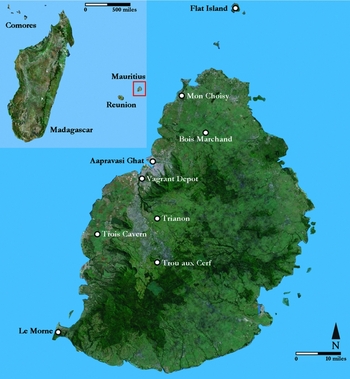
The MACH project developed from an earlier initiative under the author's direction in 2008, entitled ‘Environmental Imperialism: Colonial Archaeology in Mauritius’. The topic and title were heavily influenced by the insightful work of Crosby (Reference Crosby2004). The first season of excavation focused on a site (800m2) in the north of the island at Mon Choisy (Figure 1). A near-pristine location was identified within a region undergoing extensive development. The site was formerly plantation land and offered a valuable opportunity to record the transition to sugar agriculture. Charcoal samples pinpointed the shift to agrarian soils to the first quarter of the nineteenth century (dated by the Poznań Radiocarbon Laboratory using OxCal v3.10 to AD 1680 (27.2%), AD 1740/1800 (68.2%), AD 1940 at 95.4% probability), corroborating historical records for agricultural expansion into this region as sugar production intensified under British rule (Allen Reference Allen1999: 12). Pollen grains were not recovered from the virgin soils, but those found in the upper layer were indicative of imported species.
The island of Mauritius, showing the location of key sites discussed in the text.

This promising initial season catalysed broader surveys in 2009 and 2010, incorporating land-based and coastal reconnaissance to assess the potential for slave, indentured, maritime and environmental archaeologies. For the first time on Mauritius, geophysical surveys (magnetometry, electrical resistivity and ground-penetrating radar) were undertaken, providing a foundation on which to start to build a systematic, global approach to the archaeology of the island, rather than focusing on specific colonial enclaves or time periods. Surveys funded by the Australian National University were undertaken to identify evidence for early non-European settlement. These were conducted as part of reconnaissance work on the sites shown in Figure 1 and also coastal, volcanic (Trou aux Cerf) and lakeshore regions. The broad survey strategy was to identify the presence of ancient technologies (i.e. chipped tools) and evidence for habitation in cave systems such as Trois Cavern. These investigations proved unsuccessful and echoed results from other island enclaves such as the Seychelles, although Diego Garcia does have earlier evidence of charcoal (Atholl Anderson pers. comm.). Future plans for the MACH project include establishing baseline data for the island, including artefact catalogues and a dendrochronology profile, as well as an ambitious plan to perform a LiDAR scan of key regions to investigate possible slave-dispersal routes during episodes of maroonage (flight from the plantation).
Viewing slavery through resistance and the body
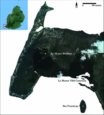
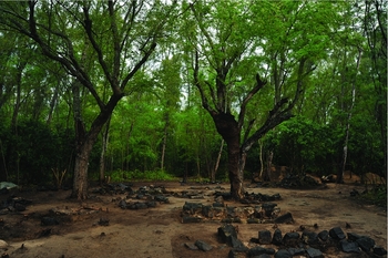
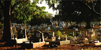
The Le Morne Cultural Landscape was inscribed as a UNESCO World Heritage Site in 2008, based solely on intangible heritage (Bakker & Odendall Reference Bakker and Odendall2008). This consists of oral history recounting how slaves threw themselves to their deaths upon seeing soldiers making their way to their refuge. The slaves died needlessly; the soldiers were coming to tell them that they were emancipated. The inscription refers specifically to the plateau, Le Morne Brabant (Figure 2), as a final sanctuary for marooning slaves. Surveys in 2009 incorporated: the plateau; Îlot Fourneau, a small islet apparently used during the French colonial period for punishing slaves; two abandoned settlements, Trou Chenille and Macaque (Makak); and the Le Morne ‘Old Cemetery’. The cemetery (Figure 3) finds no comparanda in the wider region; it therefore offers a unique Indian Ocean reference point for Atlantic sites (e.g. Hansen & McGowan Reference Hansen and McGowan1998; Pearson et al. Reference Pearson, Jeffs, Witkin and MacQuire2011).
Le Morne Brabant and key sites that have been surveyed or excavated.

Le Morne ‘Old Cemetery’ (photograph: Yves Pitchen).

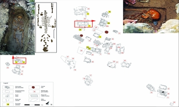
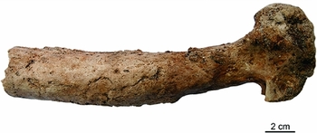
The Le Morne Heritage Trust Fund identified five ‘structures’ of various dimensions, evidently delineating graves. A concerted programme of field survey incorporating geophysics revealed 21 structures (Figure 4) and provided the basis for excavation in 2010, 2012 and 2013; the total number of known structures is now 45. We believe that the area of the cemetery could extend well beyond the initial estimate (3600m2), and perhaps incorporate different zones of burial clustered on the sandbank. At a conservative estimate, at least 70 individuals were buried in the sector currently under investigation, and probably many more in the wider area. The initial season of excavation unearthed 11 entire skeletons, six sub-adults (Appleby et al. Reference Appleby, Seetah, Calaon, Čaval, Janoo and Teelock2014) and five adults. All the skeletons were aligned south-west to north-east, effectively facing the Brabant (a basaltic monolith dominating the peninsula). The one exception was a neonate placed between its mother's legs, aligned in the opposite orientation (burial 1, Figure 4). Later seasons of work revealed the complexity of this site. Numerous burials did not follow the south-west to north-east alignment and were recovered from deeper interments, some without any evident grave marker. In general, while osteological and isotopic analysis of the remains recovered in 2010 revealed an ‘adequate diet’ and relatively few indications of disease (although dental disease was prominent; see Appleby in Seetah Reference Seetah2010a), the remains from later seasons, ostensibly from an earlier phase of burial, indicated a much higher incidence of disease, particularly inflammatory conditions (Figure 5).
Plan of graves at Le Morne ‘Old Cemetery’; burials 1 & 7 highlighted.

Osteomyelitic femur from structure 24 at Le Morne ‘Old Cemetery’; 2012 season (photograph: Jonathan Santana).

Finds from the Le Morne ‘Old Cemetery’ reveal nuanced details about the life-ways of the interred. Although the material culture is European in origin, it has been used in a manner reminiscent of African traditions, or, more accurately, Afro-Malagasy (see below). In this sense the objects are not European, African or Madagascan, they are Mauritian (Seetah Reference Seetah2015a).
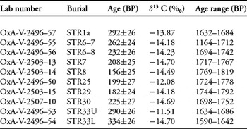
Given the immense local significance of the Brabant, which is a particular focal point for Mauritians of African descent, two issues were identified by the Le Morne Heritage Trust Fund as critical: the ethnic origin of those interred in the cemetery and its period of use. Coins recovered from burial 7 (Figure 4) suggested a period of active use around AD 1835–1850. Subsequent radiocarbon analysis (Table 1) gave dates that were approximately 100 years earlier than anticipated. It is possible that the results were offset due to depleted carbon in the diet of those buried, offering an explanation for the earlier dates (Thomas Higham pers. comm.).
AMS radiocarbon dates (all dated materials derived from human remains, excavated from within grave contexts and analysed by Rosa Fregel).

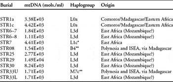
The more significant issue of ethnicity was of national importance. This had the potential of securely linking the cemetery to the period of slavery or emancipation, thereby providing the tangible evidence to support UNESCO inscription. The Minister of Arts and Culture personally announced the results to news crews and journalists (Seetah Reference Seetah2015b). In the first use of the technique on human remains, mitochondrial aDNA—the maternal lineage—was successfully extracted from 11 individuals; of these, nine were identified as being of East African, probably Mozambican, origin, and two were Madagascan (Table 2). These results lead us tentatively to conclude that the cemetery contains the remains of the very first emancipated, freeborn, Mauritians; that is, inherently free, as enshrined in law, and distinctfrom those granted freedom (gens de couleur libre).
Results of aDNA analysis (by Rosa Fregel).

*The L1c haplogroup has not been observed in the published data; the motif without 16147T mutation (haplotypes not shown) has, however, been observed in Eastern Africa.
**B4 and M7c lineages probably reached Mauritius via the Malagasy slave trade.
The excavation is at an early stage with much work remaining, but the site has considerable potential both in terms of local heritage and wider research. The local response to inscription has been positive but also revealing; dedication of the site as a World Heritage Site paved the way for the first extensive osteological, aDNA and dating analysis of a cemetery. It has also provided a focal point from which archaeological heritage and its interpretation can flourish in the wider region (Chowdhury Reference Chowdhury2006; Colwell-Chanthaphonh et al. Reference Colwell-Chanthaphonh, le Chartier and Jacquin-Ng2014). Although the plateau has been designated as a World Heritage Site, the remaining land, i.e. the Brabant itself and a portion of the buffer zone, is under the ownership of one individual. At the time of writing, he remains reluctant to allow continued research, despite pressure from the Le Morne Heritage Trust Fund, and indeed from the Prime Minister and other members of the government. In itself, this speaks volumes about the potential that heritage has within this setting, relevant to the nation as a whole, and played out at the uppermost level of political life.
At a regional level, given the antiquity and complexity of slavery in the Indian Ocean (Campbell & Alpers Reference Campbell and Alpers2006) and the role played by Mauritius, Réunion, the Andaman and other islands, the Le Morne cemetery offers an important comparison for Atlantic African burial sites. The wealth of evidence regarding historic period African burial, with exceptions in South Africa (see for example Cox & Sealy Reference Cox and Sealy1997; Cox et al. Reference Cox, Sealy, Schrire and Morris2001; Finnegan et al. Reference Finnegan, Hart and Halkett2011), has been studied overwhelmingly from North and Latin American contexts. Potential points of comparison lie in understanding: how slave communities procured and developed their own material culture (White Reference White2011); how they used burial as a mechanism to maintain cultural connections to ancestral communities (Jamieson Reference Jamieson1995; Kusimba Reference Kusimba2004); comparison between sites, for example, within the context of osteological assessment (Corruccini et al. Reference Corruccini, Handler, Mutaw and Lange1982); the objects used as part of the burial process (Pearson et al. Reference Pearson, Jeffs, Witkin and MacQuire2011: 99–141); and the positioning of burial grounds within a landscape context (Hansen & McGowan Reference Hansen and McGowan1998; Pearson et al. Reference Pearson, Jeffs, Witkin and MacQuire2011; see also sites listed in Jamieson Reference Jamieson1995). In addition, there is potential for studying the early development of syncretism. In Mauritian tradition this is termed longanis, and copious evidence for this practice was noted at the cemetery (Seetah Reference Seetah2015a). It is ubiquitous around the island. Historical records suggest that the development of longanis stretched back into the colonial period (Allen Reference Allen and Seetah2016) and is linked closely with the continuation and development of African healing or harming rites. Longanis is an important Indian Ocean and—as there was a large influx of East Africans into Mauritius—potentially East African example of syncretism that contrasts with the West African form seen in the Atlantic, for example, in Haiti, at New Orleans (Fandrich Reference Fandrich2007), in Brazil (Engler Reference Engler2012) and in the West Indies (Bilby & Handler Reference Bilby and Handler2004). Thus, Le Morne offers a number of ways to add critical depth to our understanding of the African diaspora, slave life-ways and underlying details of cultural development during slavery and since abolition. In turn, this serves to connect the various phases of labour provision during the period of slavery, as well as global phenomena related to migration in the Indian Ocean.
A first view of the archaeology of indenture
While Le Morne has potential for the study of slavery, another facet of Mauritian archaeology could have an impact on the development of global archaeological practice more generally: the archaeology of indenture. Considered by one historian as ‘a new system of slavery’ (Tinker Reference Tinker1974), others have emphasised the considerable and nuanced differences between slavery and indenture (Allen Reference Allen1999: 57–58). In AD 1834, soon after the abolition of slavery, Britain turned to South Asia and India, in particular, to find workers to fill the labour void. The evident success of this system catalysed the displacement of over two million people from Asia, Africa and Melanesia (Carter et al. Reference Carter, Govinden and Peerthum2003) to the Indian Ocean and islands in the Pacific and Caribbean. Given the wide geographic impact, it is surprising that this episode has remained virtually unexplored by archaeologists. To the author's knowledge, no dedicated programme of excavation currently exists that focuses on this globally significant diaspora (as distinct from convict labour or movements of indentured Europeans). One important site, the Seville plantation in Jamaica, serves as a potential starting point within an Atlantic context (Armstrong & Hauser Reference Armstrong and Hauser2004). In essence, indentured archaeology reflects on social differences between slaves and labourers. Architectural features in the form of sacred structures are evident throughout the landscape, clearly illustrating that the labourers kept their religion. As is the case in the archaeology of slavery, however, there are few material signatures, even from sites that are tied closely to the indentured system (Calaon Reference Calaon2011).
The role played by Mauritius in the indentured diaspora gained international recognition in 2006 with the inscription of Aapravasi Ghat as an UNESCO World Heritage Site. As the site where the system of indenture was initially implemented, few places are more appropriate for commencing an archaeological interrogation of this subject.
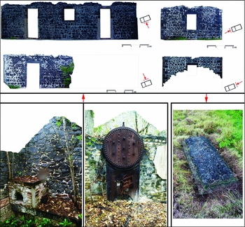
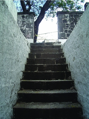
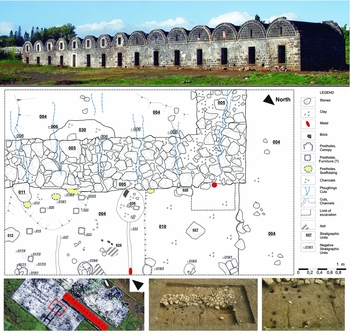
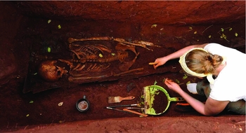
Within the indentured paradigm, viewing the ‘island as a site’ is proving particularly relevant. This specific approach was developed and implemented to study a range of sites concurrently. It describes a survey strategy that is underpinned by historical research, and integrates desk-based spatial data with non-destructive, on-site reconnaissance. These data are woven into an interpretative framework describing patterns of connectivity between points in the landscape: in effect, attempting to understand the nexus between ideologies (Western or imperial) and archaeological outcomes. Work on Flat Island, a quarantine base complete with hospital and cemetery (Figure 7), is therefore viewed as an essential complement to Aapravasi Ghat, the physical landing point of immigrants (Figure 8) on the island proper, again complete with hospital block but with the addition of a dedicated administrative centre. Trianon, a set of barracks situated on a plantation and probably the dwelling of sirdars (established labourers who served as intermediaries between the plantation owners and the contract workers) (Figure 9) (Calaon et al. Reference Calaon, Čaval, Morales-Mateos, Seetah and Teelock2012), provides an insight into the living conditions of (elite?) labourers, although it does not represent the actual habitation of the plantation workers themselves. The physical response to absenteeism/vagrancy (absconding workers) is witnessed in the construction of the Vagrant Depot, a prison for labourers. Finally, there is Bois Marchand (Figures 6 & 10), a formal and functioning cemetery with sections dedicated for indentured workers. Since 2011, excavations at Bois Marchand have unearthed a unique snapshot of the island's population at that time. In addition to an estimated 500 interred individuals, Bois Marchand cemetery has extensive burial records that date back to its inception, detailing demography and cause of death.
Bois Marchand Cemetery (photograph: Yves Pitchen).

Flat Island; top: details of the hospital block; bottom right: kitchen; bottom centre: possible desalination paraphernalia; bottom left: tomb from cemetery.

The Steps of the Aapravasi Ghat, UNESCO World Heritage Site (image used with permission of the Aapravasi Ghat Trust Fund).

Trianon Barracks; above: the row of dwellings; below: ground-penetrating radar results (lower left, undertaken by Branko Mušič) and plan of the foundation of a structure (main), possibly used for housing livestock (credit: Diego Calaon), as seen in subsequent excavations (lower centre and right).

Excavation at Bois Marchand (photograph: Yves Pitchen).

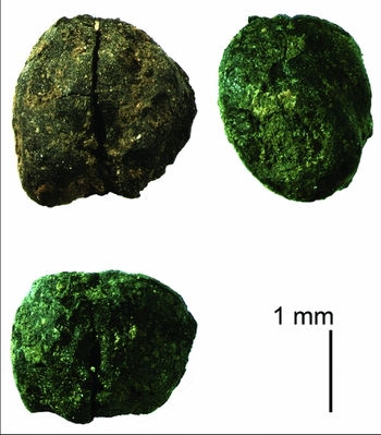
These sites effectively encapsulate the entire trajectory of the indentured diaspora within a geographically contained and highly relevant test case. Importantly, the ‘island as site’ model aligns with the plans of the Aapravasi Ghat Trust Fund to develop specific cultural routes that illustrate aspects of the indentured diaspora community. The labourers were very much tied, contractually and physically, to individual plantations, and we can still recognise aspects of the administrative process: for example, dependence on quarantine and expansion of burial grounds to deal with disease, and the reaction to absenteeism. Archaeology also offers the potential to assess the colonial mind-set as it related to specific issues, such as how the process of accepting labour onto the island changed from one imperial administration to the next (Calaon Reference Calaon2011). To this we can add high-resolution details of life-ways that connect directly to the labourers themselves in terms of health, diet (Figure 11) and social practice.
Chickpea, Cicer arietinum, from Trianon Barracks (photograph: Jacob Morales-Matoes).

Focusing on one particular issue: what other drivers, besides abolition, influenced the transition to indentured labour? Investigating this question could reveal motivations that archaeology is well equipped to address. Alongside the abolition of slavery, the removal of preferential tariffs for West Indian sugar intensified sugar production in Mauritius, thereby requiring more labour. Although these were undoubtedly the main catalysts for the labour migrations of this period, a number of factors complicate the simplicity of this reasoning. The illegal slave trade was rife and continued up to 1827 (Allen Reference Allen2010). Coupled with the apprenticeship system, mandating six years’ service by emancipated slaves, these two factors should have provided a buffer for the plantation owners during the period directly after emancipation. Nevertheless, history records the appeals of the landowners for additional labour (Allen Reference Allen2010). There is at least one factor that may have had implications that are at present poorly understood and to which Le Morne may serve as a signpost. The earlier phases of interment at Le Morne, speculatively assigned to the period directly after emancipation, show extensive incidence of disease and possible malnutrition. Bois Marchand cemetery covered some 400 acres when established in 1867 (Pike Reference Pike1873: 401). Although later in date, it was created to accommodate the massive death toll resulting from epidemics of malaria and cholera. In 1867, 41000 people, 10% of the entire population, died from these conditions (Pike Reference Pike1873: 110). The administrative response was to expand quarantine (highlighting the purpose of Flat Island) and cemetery infrastructure. The British could not have then known that mosquitoes were responsible for the spread of malaria as that was first discovered by Sir Ronald Ross some 30 years later. The role of disease, while featuring strongly in Atlantic research on labour provision (Pearson et al. Reference Pearson, Jeffs, Witkin and MacQuire2011: 155), has remained largely unstudied within an Indian Ocean context, certainly in terms of archaeology (see Arnold Reference Arnold1991, for a detailed historical overview of the Indian Ocean; and Boodhoo Reference Boodhoo2010, for Mauritius specifically), and could prove highly relevant to our understanding of labour diasporas in this basin.
Conclusions: small islands as a microcosm of world archaeology
Mauritius has sites that could provide a completely novel view of archaeology in the region. The archaeology is distinctly colonial and post-colonial, and in many ways ‘modernarchaeology’ (Orser Reference Orser2008). It is supported by an abundant textual record and offers us a deeply relevant view of what has taken place (and is still taking place) more generally in the world. The island is an exemplar of the globally connected post-medieval world, underpinned by relationships far more complex than slave or labourer vs master or European vs non-European. At a regional level, it is well situated to contribute to the recent and rapidly expanding interest in the Indian Ocean. Major research projects span the period from protohistory (Fuller et al. Reference Fuller, Boivin, Hoogervorst and Allaby2011) to the historic period, with work in an East African context (Biginagwa Reference Biginagwa2009) of particular interest. Regional studies offer critical areas for more immediate comparison; for example, slave communities in Kenya, Zanzibar and Pemba (Lodhi Reference Lodhi1973; Marshall Reference Marshall2012), the important influence of Madagascan communities (Crossland Reference Crossland2001) for Mauritius and the region more widely, and indirect relationships that connected administrations across this zone, but were strictly beyond the Indian Ocean, with Suakin (Rhodes Reference Rhodes2011), for instance. Future work will emphasise how ideas of identity construction (Wynne-Jones Reference Wynne-Jones2007) can be useful for the local context (Colwell-Chanthaphonh & de Salle-Esso Reference Colwell-Chanthaphonh and de Salle-Esso2014). Furthermore, mechanisms proposed for continental Africa might have potential for understanding labour and environmental histories (Lane Reference Lane2010, Reference Lane2014), as well as more specific issues relating to administrative policy; for example, the ecological consequences of introducing draft animals (Bernard & Parker Reference Bernard and Parker2006).
On a more theoretical level, Le Morne contributes to a wider discussion on why archaeologists need to pay careful attention to the role of oral history (Schmidt & Walz Reference Schmidt and Walz2007). The differential sex ratios of incoming workers to Mauritius, both slave and labourer, underline the significant context of gender relationships (Allen Reference Allen1999: 43, 58; Croucher Reference Croucher2007). Finally, the UNESCO World Heritage Site inscription of Le Morne and the influence of Madagascan and African peoples on local cultural heritage establishes another example that highlights the role of Africa in the wider world (Police Reference Police, Teelock and Alpers2001: 81–110; MacEachern Reference MacEachern2007; Seetah Reference Seetah2015a). Although comparisons with East Africa are the most immediately relevant, these should ultimately serve as points of departure for wider, global-level comparative studies that take in differences between landscapes, administrative policy and transitions from slavery, as noted in the Atlantic (Armstrong Reference Armstrong2009). Farther afield, demographic and social differences could be compared: such as diasporas involving predominantly South Asians in the Indian Ocean vs East Asian in the Pacific, at Hawaii for example (Lui Reference Lui, Cheng and Bonicich1984).
Mauritius serves as an essential connection between African, Asian, European and Atlantic research agendas in a way no other location does. It is a critical node both in the (predominantly African) slave diaspora, and the later (predominantly Asian) indentured diaspora, opening up intra- and inter-comparative dimensions. Developments on Mauritius enable us to consider how research in such locations can contribute to debates regarding what archaeology is and what it will become. Small colonial enclaves provide a contained set of motifs that mirror transitions taking place on a larger scale elsewhere in the world. Scale and complexity, however, are different entities; small scale does not equate to muted complexity. In much the same way, small islands serve as a lens through which to view dynamic interactions between groups after colonialism, i.e. between former imperial Europe, modern-day dependencies and newly formed republics (Seetah Reference Seetah2010b). In future we may see archaeological theory and practice applied as the ‘direct offspring of European colonial archaeology’ (Willems Reference Willems2009), returning as essentially different entitiesthat have absorbed the ideals and requirements of the local community in new settings: accents of a language that has changed in its native land and that serves to promote novel conversation across pedagogic levels.Mauritian archaeology demonstrates how the discipline may evolve as the ideas of the global archaeological community are expressed, requiring a reflexive assessment of our genuinely universal subject. Why it has taken us so long to foster an ‘archaeology of indenture’ is a question that needs to be considered at a disciplinary level, particularly given the global impact of this diaspora, and the fact that historical, community and heritage archaeologies have become increasingly active fields of engagement for the international archaeological community.
Mauritius offers one view of what historical archaeology looks like on the ground, and could look like in the future more widely in the Indian Ocean. For Mauritius, archaeology has furnished a physical focal point for the island's early development, removed from colonial bastions, as well as a material contextualisation for its historiography based on more than just architectural features in the landscape. For the discipline, the island offers insight into the complexity of slave life-ways more broadly, and a unique point of comparison with the Atlantic; the elements of burial practice as transposed, recreated and re-enacted by groups under similar conditions in vastly different locations. It showcases the first steps towards a wholly new investigative agenda: indenture. Ultimately, Mauritian archaeology offers a view of how the subject can develop and contribute at all levels, from our knowledge of the Indian Ocean to understanding the globalised, pluralistic and deeply connected modern world.
Acknowledgements
My sincere thanks to members of the MACH project, and in particular Saša Čaval and Diego Calaon. This work was funded by: The British Academy (SG-10085/SG-54650); the British Council (‘Darwin Now’ Award); the McDonald Institute for Archaeological Research at the University of Cambridge; The Truth and Justice Commission, Mauritius, and the Society of Antiquaries of London. Sincere thanks to Lynn Meskell, Aleksander Pluskowski and two reviewers for insightful commentary on earlier versions of this text.