INTRODUCTION
The last glacial maximum (LGM; centred on 21 ka) was the most recent time when ice sheets were at their maximum extent and hence sea level was at its lowest (Clark et al., Reference Clark, Dyke, Shakun, Carlson, Clark, Wohlfarth, Mitrovica, Hostetler and McCabe2009; Hopcroft and Valdes, Reference Hopcroft and Valdes2015). Lowered sea level led to dramatic increases in land area in some parts of the world. Equally dramatic changes in the distribution of terrestrial biomes were driven by decreases in temperature, changes in the distribution and amount of precipitation, and lower atmospheric CO2 (Ganopolski et al., Reference Ganopolski, Rahmstorf, Petoukhov and Claussen1998; Shakun and Carlson, Reference Shakun and Carlson2010; Alder and Hostetler, Reference Alder and Hostetler2015; Jiang et al., Reference Jiang, Tian, Lang, Kageyama and Ramstein2015).
Mapping regional changes in palaeogeography and climate at the LGM through the development of palaeoenvironmental proxy records from around the world is key to understanding modern patterns of biodiversity (Weigelt et al., Reference Weigelt, Steinbauer, Cabral and Kreft2016; Blonder et al., Reference Blonder, Enquist, Graae, Kattge, Maitner, Morueta-Holme and Ordonez2018; Ye et al., Reference Ye, Delgado-Baquerizo, Soliveres and Maestre2019) as well as the timing and trajectory of human dispersal (Gavashelishvili and Tarkhnishvili, Reference Gavashelishvili and Tarkhnishvili2016; Vahdati et al., Reference Vahdati, Weissmann, Timmermann, de León and Zollikofer2019) and adaptation (Williams et al., Reference Williams, Ulm, Sapienza, Lewis and Turney2018). The mapping of biome distributions at the LGM also provides empirical insight into climate at the LGM and therefore the opportunity to evaluate the reliability of climate and carbon/water models in reproducing observations from outside the comparatively small range of recent observed climate variability (Harrison et al., Reference Harrison, Bartlein, Izumi, Li, Annan, Hargreaves, Braconnot and Kageyama2015).
Computer simulations, now Dynamic Global Vegetation Models (DGVMs), have long been used to simulate biome distributions in the present (Prentice et al., Reference Prentice, Cramer, Harrison, Leemans, Monserud and Solomon1992) and at the LGM (Harrison and Prentice, Reference Harrison and Prentice2003). The spatial distribution of vegetation types is driven by one or more general circulation models (GCMs), more recently incorporating other factors including plant responses to CO2 (e.g., Cleator et al., Reference Cleator, Harrison, Nichols, Prentice and Roulstone2019), fire regime (e.g., Calvo and Prentice., Reference Calvo and Prentice2015; Scheiter et al., Reference Scheiter, Higgins, Beringer and Hutley2015) and herbivore biomass (Zhu et al., Reference Zhu, Ciais, Chang, Krinner, Peng, Viovy, Peñuelas and Zimov2018). Simulations are tested against observations derived from well-dated proxy records, mostly commonly palynological investigations (Bartlein et al., Reference Bartlein, Harrison, Brewer, Connor, Davis, Gajewski, Guiot, Harrison-Prentice, Henderson, Peyron and Prentice2011; Harrison et al., Reference Harrison, Bartlein, Izumi, Li, Annan, Hargreaves, Braconnot and Kageyama2015).
The spatial distribution of observations of vegetation at the LGM (here defined as 21 ± 2 ka; Hopcroft and Valdes, Reference Hopcroft and Valdes2015) is clearly critical to achieving an observation-informed representation of biome distribution at the LGM. Observations of sufficient quality for this purpose are currently weighted heavily toward studies from the higher latitudes, with much patchier representation of low latitude areas (Bartlein et al., Reference Bartlein, Harrison, Brewer, Connor, Davis, Gajewski, Guiot, Harrison-Prentice, Henderson, Peyron and Prentice2011; Cleator et al., Reference Cleator, Harrison, Nichols, Prentice and Roulstone2019). This in turn means that observations provide no empirical constraints on vegetation for large parts of the terrestrial biosphere, with those in the southern hemisphere biosphere particularly poor (Cleator et al., Reference Cleator, Harrison, Nichols, Prentice and Roulstone2019).
Northern Australia is one region where there is limited information on vegetation distribution at the LGM (Pickett et al., Reference Pickett, Harrison, Hope, Harle, Dodson, Peter Kershaw and Colin Prentice2004), with the only sites in the global database of Bartlein et al. (Reference Bartlein, Harrison, Brewer, Connor, Davis, Gajewski, Guiot, Harrison-Prentice, Henderson, Peyron and Prentice2011) located on the northeast coast—a wet, mountainous, tropical forest covered region that is atypical of the rest of tropical Australia. At the LGM, lowered sea level (Yokoyama et al., Reference Yokoyama, Hirabayashi, Goto, Okuno, Sproson, Haraguchi, Ratnayake and Miyairi2019) meant that much of the modern landmass of northern Australia was ~300 km inland of the LGM coast (Williams et al., Reference Williams, Ulm, Sapienza, Lewis and Turney2018). Currently, the equivalent distance inland reduces mean annual precipitation from 1700 mm to approximately1000 mm. This rainfall gradient inland from the coast, along with potential changes in monsoon strength at the LGM (Jiang et al., Reference Jiang, Tian, Lang, Kageyama and Ramstein2015; Denniston et al., Reference Denniston, Asmerom, Polyak, Wanamaker, Ummenhofer, Humphreys, Cugley, Woods and Lucker2017; Yan et al., Reference Yan, Wang, Liu, Zhu, Ning and Cao2018) means northern Australia is sensitively placed to provide a meaningful test of DGVM skill using LGM boundary conditions. Recent modelling studies of vegetation distribution during the LGM using a number of different DGVMs and GCMs, at a range of resolutions, have not converged on a common result for the northern Australian region, with simulations broadly characterizable as ranging from grassland through savanna woodland to tropical forest (Calvo and Prentice, Reference Calvo and Prentice2015; Gavashelishvili and Tarkhnishvili, Reference Gavashelishvili and Tarkhnishvili2016; Zhu et al., Reference Zhu, Ciais, Chang, Krinner, Peng, Viovy, Peñuelas and Zimov2018; Lu et al., Reference Lu, Miller, Zhang, Wårlind, Nieradzik, Sjolte, Li and Smith2019; Chen et al., Reference Chen, Zhu, Ciais, Huang, Viovy and Kageyama2019; Dallmeyer et al., Reference Dallmeyer, Claussen and Brovkin2019).
Here we present a detailed palynological investigation of the LGM from Girraween Lagoon near Darwin, on the central northern coast of Australia. This site is representative of the lowland tropical savanna-woodlands of northern Australia, at the southern end of the Indonesian-Australian Summer Monsoon (IASM) region. Scheiter et al. (Reference Scheiter, Higgins, Beringer and Hutley2015) have demonstrated that Australian tropical savannas are currently sensitive to both climate change and fire management. It is the primary purpose of this paper to provide a detailed assessment of the response of vegetation to LGM environmental conditions at a location representative of the tropical savannas that currently cover approximately 20% of Australia's landmass.
STUDY AREA AND METHODS
Study area
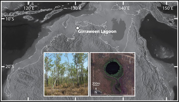
Girraween Lagoon is one of a number of lagoons that occur across the Northern Territory's (NT's) Darwin region (Fig. 1). The site is located within the Howard River sub-catchment of Darwin Harbour (12.517°S, 131.081°E; 28 km inland from the harbour's northern shoreline and tidal estuaries 15 km west; Schult, Reference Schult2004). An extensive overview of the regional context has been provided by Rowe et al. (Reference Rowe, Brand, Hutley, Wurster, Zwart, Levchenko and Bird2019a) and only a brief description is given here.
(color online) Location of Girraween Lagoon with current coastline mapped onto the landmass of Sahul, exposed by sea-level fall at the LGM. The outline of Sahul shown at a sea level equivalent to the 120 m isobath. Inset is a satellite image of the site and an image of the current dryland vegetation around the site.

The Köppen-Geiger classification (as redefined by Peel et al., Reference Peel, Finlayson and McMahon2007) characterises the northern NT climate as Tropical Savanna (code Aw). A distinctive feature of this region's climate is strong rainfall seasonality, driven by the annual north-south migrating Intertropical Convergence Zone (ITCZ) with associated convective activity and extreme weather events such as tropical cyclones. El Niño–Southern Oscillation (ENSO) is currently an important driver in inter-annual variations in rainfall of the region (Charles et al., Reference Charles, Petheram, Berthet, Browning, Hodgson, Wheeler and Yang2016). Mean annual Darwin rainfall is 1731.2 mm, and approximately 95% of this total falls during the wet-season months (November–April). Darwin experiences uniformly high temperatures; mean monthly maximum-minimum temperatures are 32.1°C and 23.2°C, respectively. Evaporation is also high year-round, but exhibits a strong seasonal pattern, ranging from ca. 200 mm per month during the October wet season build-up to ca.125 mm per month during the middle (June) of the dry season (Charles et al., Reference Charles, Petheram, Berthet, Browning, Hodgson, Wheeler and Yang2016; Bureau of Meteorology, 2019, Darwin Airport, station 014015, 1941–2018).
Girraween Lagoon is a perennial fresh waterbody, with a surface area of 45 hectares (ha) and a maximum depth of 5 m. Water drains into the lagoon from a catchment of 917 ha. The lagoon is immediately underlain by lateritized and heavily weathered sandy to clayey Cretaceous sediments (30–50 m depth). These sediments are underlain by a Proterozoic dolomite aquifer. The lagoon originated as sinkhole due to collapse into voids created by dissolution of this underlying dolomite (McFarlane et al., Reference McFarlane, Ringrose, Giusti, Shaw and Brown1995).
Modern catchment vegetation comprises tropical mesic open-forest savanna and/or savanna woodland (Hutley et al., Reference Hutley, Evans, Beringer, Cook, Maier and Razon2013; Moore et al., Reference Moore, Beringer, Evans, Hutley, McHugh and Tapper2016). Eucalyptus tetrodonta, E. miniata, and Corymbia polycarpa (all Eucalypteae: Myrtaceae) dominate the overstorey. Other prominent tree species include Erythrophleum chlorostachys (Caesalpinioideae: Fabaceae), Lophostemon lactifluus (Lophostemoneae: Myrtaceae) and Terminalia ferdinandiana (Combretaceae). In the understorey, Sorghum and Heteropogon (Poaceae) species are abundant. Saplings, shrubs (e.g., Pandanus [Pandanaceae], Grevillea [Proteaceae], Calytrix [Chamelaucieae: Myrtaceae] and broad-leaf herbs (e.g., Spermacoce [Rubiaceae], Murdannia [Commelinaceae)], Flagellaria [Flagellariaceae]) vary in density and height, dependent on seasonal rainfall variation and fire history. Variable transitional plant communities occur on approach to the water, including mixed monsoonal and/or riparian forest associations; see Web and Tracey (Reference Webb, Tracey and Groves1994) for discussion on monsoon-type drier rainforests, and Brock (Reference Brock1995) for survey results on Darwin remnant mixed species woodland. Melaleuca symphyocarpa, M. viridiflora and/or M. cajuputi (Melaleuceae: Myrtaceae) along with Cyperaceae-dominated sedgeland, form a swamp fringe around open water. Aquatic plants include Nymphaea hastifolia and N. violacea (Nymphaeaceae) as well as submergents such as Najas (Hydrocharitaceae). Girraween's catchment has burnt ≤ 6–7 times since the year 2000, equating to a fire return interval of 2–3 years, a typical regime of northern NT savanna (Russell-Smith and Yates, Reference Russell-Smith and Yates2007).
The Larrakia Nation maintains Darwin regional traditional customary associations with Country, including within the Howard River area and Girraween Lagoon catchment (Burns Reference Burns1999; Wells, Reference Wells2001). Wells (Reference Wells2001) provides an account of Darwin history from a Larrakia perspective.
Methods
Girraween Lagoon was cored using a floating platform with hydraulic coring-rig. A 19.4 m core in 1 m sections was collected to the point of bedrock. The focus of this paper is the 478–598 cm section encompassing the LGM as well as the interval immediately before and after the LGM. Details and imagery of field, laboratory and microscope methods are reported in Rowe et al. (Reference Rowe, Brand, Hutley, Wurster, Zwart, Levchenko and Bird2019a, Reference Rowe, Brand, Hutley, Zwart, Wurster, Levchenko and Bird2019b).
Pollen and charcoal analysis
Two cubic centimeter sediment samples were processed for pollen and microcharcoal analysis. Sample preparation followed the techniques as detailed in Rowe et al. (Reference Rowe, Brand, Hutley, Wurster, Zwart, Levchenko and Bird2019a, Reference Rowe, Brand, Hutley, Zwart, Wurster, Levchenko and Bird2019b; see also references used therein). Chemical preparations (including Na4P2O7, KOH, HCl, acetolysis and C2H5OH washes) were selected to initially disperse the organic-mineral matrix then progressively remove humic acids, calcium carbonates, bulk (in)organics, and silicates, as well as to render pollen ornamentations visible. Sieving took place at 7 μm and 125 μm. A Lycopodium spike (Lunds University batch 3862) was added during laboratory preparations, to determine concentrations of pollen and microcharcoal particles. Final residues were mounted in glycerol. Pollen counts are a minimum of 150 grains (including spores) per sample (single sample exception identified and described below). Pollen identification was based upon regionally representative floral reference libraries in development by the lead author (CR), and on online resources including the Australasian Pollen and Spore Atlas (http://apsa.anu.edu.au/). For additional information on Myrtaceae pollen identification, refer to Stevenson et al. (Reference Stevenson, Brockwell, Rowe, Proske and Shiner2015).
Insight into plant ecologies was gained through sources such as FloraNT (eflora.nt.gov.au). All data were plotted using TGView (Grimm, Reference Grimm2004). A dendrogram produced by CONISS (Grimm, Reference Grimm1987; Reference Grimm2004) was used to help in selection of diagram zone boundary location. Pollen was divided into eight groups to capture plant form and/or vegetation type. These groups were then classified further and allocated into plant-function and/or environmental response categories: dryland and wetland associated Myrtaceae, other woody taxa (sclerophyll or monsoonal forest affiliated), Poaceae, herbaceous taxa, pteridophtes and wetland associates (plant terms ‘wetland’ and ‘aquatic’ are used in reference to areas of seasonal verses permanent inundation, respectfully). These groups were then condensed further, and pollen allocated into plant-function and/or environmental response categories. Such categories helped evaluate fire tolerances as well as assess wet–dry continuums. Rowe et al. (Reference Rowe, Brand, Hutley, Wurster, Zwart, Levchenko and Bird2019a) provide an extended discussion on the allocation and use of plant functional types for the Girraween pollen record. All pollen types are identified to the most refined taxonomic level possible. In certain cases (e.g., Fabaceae, Myrtaceae) grain morphological descriptors are included in the categorisations to help highlight differing grain types. Accounting for pollen types in this way ensures diversity within the record is not lost. Microcharcoal particles (black, opaque, angular, >10 μm in length) were counted simultaneously with pollen and as an indicator of landscape fire Charcoal, as a proxy for local to regional fire occurrence, is guided by the advice of Whitlock and Larsen (Reference Whitlock, Larsen, Smol, Birks, Last, Bradley and Alverson2002) and as used in Rowe et al. (Reference Rowe, Brand, Hutley, Wurster, Zwart, Levchenko and Bird2019a).
Hydrogen pyrolysis of stable polycyclic aromatic carbon
Fifteen samples from a subset of depth intervals were analysed for the abundance and carbon isotope composition of total organic carbon (TOC) and pyrogenic carbon (PyC), by hydrogen pyrolysis (HyPy). HyPy quantifies PyC present as stable polycyclic aromatic carbon (SPAC) which has been shown to comprise compounds of more than seven condensed polycyclic aromatic rings (Meredith et al., Reference Meredith, Ascough, Bird, Large, Snape, Sun and Tilston2012; Wurster et al., Reference Wurster, Lloyd, Goodrick, Saiz and Bird2012, Reference Wurster, Saiz, Schneider, Schmidt and Bird2013). The technique has been described in detail in a number of publications (e.g., Ascough et al., Reference Ascough, Bird, Brock, Higham, Meredith, Snape and Vane2009; Meredith et al., Reference Meredith, Ascough, Bird, Large, Snape, Sun and Tilston2012). Briefly, 25–100 mg aliquots of each sample were loaded with a molybdenum (Mo) catalyst using an aqueous/methanol (1:1) solution of ammonium dioxydithiomolybdate [(NH4)2MoO2S2]. Catalyst weight was ~10% sample weight for all samples to give a nominal loading of 1% Mo. After sample loading, the reactor was pressurized with hydrogen to 15 GPa with a sweep gas flow of 5 L min-1, then heated using a pre-programmed temperature profile, where samples are initially heated at a rate of 300°C min-1 to 250°C, then heated at a rate of 8°C min-1 until the final hold temperature of 550°C for 5 min.
Carbon abundance and isotope composition of samples were determined using a Costech Elemental Analyzer fitted with a zero-blank autosampler coupled via a ConFlow 4010 to a ThermoFinnigan DeltaVPLUS using Continuous-Flow Isotope Ratio Mass Spectrometry (CF-IRMS) at the Advanced Analytical Unit at James Cook University, Cairns. Stable isotope results are reported as per mil (‰) deviations from the Vienna Pee Dee Belemnite (VPDB) reference standard scale for δ13C values. Precisions (σ) on internal standards were better than ± 0.1‰.
Radiocarbon dating and age model development
Four samples of bulk sediment from above, within, and below the LGM section of the core were pre-treated by hydrogen pyrolysis to remove labile carbon from pyrogenic carbon (charcoal) component for radiocarbon dating. The protocol used was identical to that described in Rowe et al. (Reference Rowe, Brand, Hutley, Wurster, Zwart, Levchenko and Bird2019a, Reference Rowe, Brand, Hutley, Zwart, Wurster, Levchenko and Bird2019b). Pre-treated samples were then combusted to CO2 and reduced to a graphite target for measurement at ANSTO, as reported in Bird et al. (Reference Bird, Levchenko, Ascough, Meredith, Wurster, Williams, Tilston, Snape and Apperley2014). Age reporting follows Stuiver and Polach (Reference Stuiver and Polach1977), converted into calibrated ages using CALIB REV7.1.0 (Stuiver and Reimer, Reference Stuiver and Reimer1993, Hogg et al., Reference Hogg, Hua, Blackwell, Niu, Buck, Guilderson, Heaton, Palmer, Reimer, Reimer and Turney2013; calibration curve SHCal13). A Bayesian age-depth model was constructed for the LGM interval of core using Bacon 2.2 (Blaauw and Christen, Reference Blaauw and Christen2011).
RESULTS
Chronology and sedimentology
The depth interval of interest here incorporates two radiocarbon results. However, the overall modelled calibrated chronology is based on four radiocarbon measurements, using samples above and below our interval of interest, from the same core. All sample depths, percent modern carbon (pMC), conventional (yr BP) and calibrated (cal yr BP) radiocarbon ages are listed in Table 1, with the two radiocarbon results pertaining to this study highlighted in grey. The lowermost sample in the interval under consideration in this paper (595 cm) was modelled to ~26,500 cal yr BP, while the uppermost sample at 478 cm was modelled to 18,500 cal yr BP (Fig. 2). The interval thus encompasses a period of 8000 years, with the LGM (21,000 ± 2000 calendar years) represented by samples between 485 cm and 518 cm. The age model in this study differs from that presented in Rowe et al. (Reference Rowe, Brand, Hutley, Wurster, Zwart, Levchenko and Bird2019a) due to subsequent sub-sampling and availability of OZV443 and OZU820 (Table 1).
(color online) Age model developed for the interval of core under study. Inset is an optical image of the section from 478 to 595 cm, location of the samples for pollen analysis within the section and interval encompassing the LGM.

14C radiocarbon AMS sample results used to develop the age model presented in Figure 2.

Sediments are consistent throughout this section of the core, described as dark olive-grey (5Y, 3/2 per Munsell color charts) consolidated and fine clay with decomposed (sapric) organic material. While there is no change in the nature of the sediments in the LGM, sedimentation rate decreases substantially into the LGM (Fig. 2).
Palynological analysis
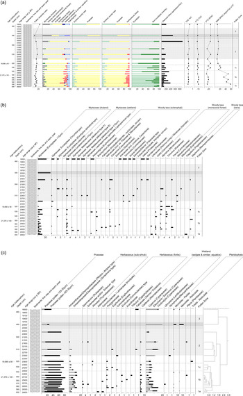
Sixty pollen taxa were identified in the end-phase last glacial pollen and microcharcoal from Girraween (Fig. 3a, b, c). Unidentified pollen accounted for an average 9% of sample pollen counts. One sample demonstrated low pollen preservation (490 cm, 19.96 cal ka BP) and was excluded from the analysis. Three pollen zones are illustrated; a lower zone labelled GIR-1 (598–524 cm below sediment surface [bss]; ca. 26.53–23.75 cal ka BP), a middle zone labelled GIR-2 (524–493 cm bss; ca. 23.75–20.3 cal ka BP), and an upper zone labelled GIR-3 (493–478 cm bss; ca. 20.3–18.5 cal ka BP).
Girraween Lagoon percentage pollen diagram plotted against depth, stratigraphy, radiocarbon results, and calibrated age range. Data presentation divided into: a) pollen group summaries, microcharcoal and geochemical analyses. Note for the δ13C spectrum we consider -12.5‰ as the cut-off for 100% C4 grass biomass; b) woody pollen taxa; c) non-woody pollen taxa. The LGM has been highlighted in light grey, with poor pollen sample preservation outlined in darker grey. All percentages derived from total pollen sum including spores. The taxonomic level at which grain identification was most confident is that provided first. All data were plotted using TGView (Grimm, Reference Grimm2004) and pollen assemblages divided into zones based on the stratigraphically constrained classification undertaken by CONISS (Grimm, Reference Grimm1987; Reference Grimm2004). (For interpretation of the references to color in this figure legend, the reader is referred to the web version of this article.)

Zonation was assisted by the numerical classifications. For example, GIR-3 samples have been separated due to very similar values for the three main taxa (Myrtaceae–Eucalyptus, Poaceae and Cyperaceae). Zone GIR-1 has been further divided into sub-zones, determined largely by variations in herbaceous pollen (GIR-1a, 598–586 cm bss, ca. 26.53–26.2 cal ka BP; GIR-1b, 586–538 cm bss, ca. 26.2–24.5 cal ka BP; GIR-1c, 538–524 cm bss, ca. 24.5–23.75 cal ka BP). Secondary zonation influences include differences in non-Myrtaceae woody plants. The lower two major zones also show an upward overall decline in charcoal accumulation, crossing over into zone GIR-3 with a sharp increase before decreasing toward the top of the core. A spike in charcoal at 496 cm is the one exception to trends in glacial burning.
Zone GIR-1 598–524 cm bss, ca. 26.53–23.75 cal ka BP
Zone GIR-1 is dominated by Poaceae (65–82% of the pollen sum), and further characterised by variable total values (and composition) in the minor dryland plant groups, as also reflected in the pollen richness index. Zone GIR-1 contains a high number of Melaleuceae, woody sclerophyll-monsoonal forest taxa (non-eucalypts) and herbaceous pollen types, notably within subzone GIR-1b (26.2–24.5 cal ka BP), after which a number of plants are lost from the record. The representation of minor plant groups and associated diversity decline into subzone GIR-1c (24.5–23.75 cal ka BP), and with relative similarity continuing into zone GIR-2. Upper subzone GIR-1c into zone GIR-2 represents a transitional phase into the LGM.
Larger sized Myrtaceae pollen (grain morphology observed as the eucalypts within the tribe Eucalypteae, see Thornhill et al., Reference Thornhill, Hope, Craven and Crisp2012; and the author CR's previous Myrtaceae pollen analysis in Stevenson et al., Reference Stevenson, Brockwell, Rowe, Proske and Shiner2015) represent the main tree signal (≤12% of the pollen sum, decreasing to 1.5% at 24.6 cal ka BP) and mixed with sparse sub-canopy tree taxa, including Brachychiton and Casuarina, and likely shrub types, Malvaceae, Fabcaeae and Arecaceae (all <2%). Monsoonal-forest affiliated Moraceae, Celtis, Timonius, Myristica and Trema co-occur in low abundances (also all <2%). Amaranthaceae/Chenopodiaceae (combining Gomphrena and Atriplex-Ptilotus pollen types) are the major herbaceous taxon (up to 14%), but gradually decline toward zone GIR-2. Other herbs (12 total sub-shrubs and forbs) are sporadic when present.
Zone GIR-1 charcoal records fluctuate, with higher accumulations through subzone GIR-1b (26.2–24.5 cal ka BP). Increases in particles occur at 26.1, 25.8 and 24.6 cal ka BP; greater charcoal coincides with higher and ongoing herbaceous occurrence and expansions in non-eucalypt woody taxa. High zone GIR-1 charcoal is recorded alongside woody (e.g., Dodonaea) and herbaceous (e.g., Euphorbia) taxa favoured by disturbance, particularly fire (Moore, Reference Moore2005; Hyland et al., Reference Hyland, Whiffin and Zich2010), as well as known open and drier habitat herbaceous ‘fire weeds’ (e.g., Solanum; Moore, Reference Moore2005).
The Cyperaceae (sedge) family and similarly grouped wetland plants such as Caldesia are consistently low (<5% of the pollen sum). No aquatic taxa are recorded. Ferns are occasional, and absent in subzone GIR-1c.
Zone GIR-2 524–493 cm bss, ca. 23.75–20.3 cal ka BP
The bulk of zone GIR-2 encompasses the LGM. Dominant Poaceae pollen percentages continue through this zone (66–76%), and combine with lower proportion, more fluctuating, and less diverse minor plant groups. Woody taxa in all ecological categories show more irregular appearance and abundance than herbaceous plants. When recorded, the eucalypts (0.5–18%) remain the primary sclerophyll tree canopy component, with sub-canopy composition including Terminalia, Acacia, Pandanus, Hakea and Fabaceae shrubs such as Daviesia. Other members of the Fabaceae family, as well as trees such as Casuarina, disappear beginning 20.7 cal ka BP. Timonius, Myristica and Trema remain, and taxa Melastoma and Euphorbiaceae-Macaranga appear in the record to characterise a monsoonal-forest signal (all <2–4%). No lianas are represented within the forest group. Non-eucalypt pollen outnumbers eucalypt pollen at 23.5 cal ka BP and 22.4 cal ka BP.
As ground cover, Amaranthaceae/Chenopodiaceae types maintain presence (ca. 4%) until 21.6 cal ka BP. Herbs such as Solanum, Euphorbia, and potential Fabaceae types occur in low abundances, also until 21.6 cal ka BP, after which herbaceous taxa are not recorded until the top of the core. Fern spore values remain low. Wetland elements are similar or slightly higher than in zone GIR-1 and primarily composed of Cyperaceae. Cyperaceae combine with Melaleuceae foremost in the upper part of this zone. A single record of aquatic pollen occurs at 22.4 cal ka BP (Nymphoides, <1%).
The scale of zone GIR-2's charcoal accumulation is skewed toward a single peak sample, dated to 20.7 cal ka BP at the top of the zone. Charcoal results are otherwise low and consistent comparative to zone GIR-1.
Zone GIR-3 493–478 cm bss, ca. 20.3–18.5 cal ka BP
The sample at 490 cm depth (age 20 cal ka BP) showed very poor pollen preservation. Vegetation shifts and fire patterns are therefore interpreted with caution. Diversity values are lowest for the record and the majority of plant groups are not recorded. Pollen is dominated by near-even percentages of grass and eucalypts; Cyperaceae (comprising Cyperus only) otherwise rise.
The top-most sample (478 cm, 18.5 cal ka BP) is contemporaneous with early-stage deglaciation. Eucalypt values increase from zone GIR-2 (to 22%), and combine with greatest presence (9.5%) sclerophyll sub-canopy woody taxa. Sub-canopy composition is a continuation of that established in zone GIR-2 (Terminalia, Acacia, Pandanus, Hakea and Fabaceae shrubs, each at higher individual values), with the reappearance of Petalostigma and Arecaceae from before the LGM. Forest associated taxa are absent. Herbaceous, sedge and fern diversity is low. A decline in Poaceae suggests vegetation structure is less open.
Charcoal accumulations progressively decline from the peak observed at 20.7 cal ka BP achieving values similar to the remainder of the record.
Pyrogenic carbon
TOC abundances are uniformly low and relatively constant through the examined interval (from 0.37 to 0.64%, Fig. 3a). PyC mass accumulation rate decreases from 33–58 μg/cm2/yr before and into the interval identified as the LGM and is relatively stable through and beyond the interval identified as the LGM, with fluxes of 9–22 μg/cm2/yr. The δ13C values of TOC exhibit a relatively narrow range from -14.7‰ to -16.1‰, indicating a substantial C4 component, with no overall trend through the interval. The δ13C values of PyC are generally lower than TOC, with a substantially greater range from -14.6‰ to -23.3‰. Overall, there is an irregular trend from lower δ13C values (generally <-20‰) prior to and at the start of the LGM, with higher values (>-20‰) toward the end of the LGM and continuing into the post-glacial period.
DISCUSSION
Vegetation dynamics
Pollen indicates that vegetation characterised by grasses with sparse trees and shrubs occupied Girraween's catchment through the period 26.5–18.5 cal ka BP. While grass communities were the most extensive and continuous pollen-plant group across the area, at no time was the vegetation grass only. This conclusion is supported by high δ13C values in TOC in the sediments throughout the interval under investigation which remain always higher than -16.1‰. This indicates a dominant but not exclusive C4 (grass) contribution to organic carbon in the sediments. A significant C4 component also contributed to the PyC preserved in the lake sediment, but δ13C values are lower than for TOC, again indicating that the region was exclusively C4 (discussed below). Grasses did not extensively co-exist with other ground layer taxa. Although monsoonal-forest taxa (semi-deciduous trees and shrubs, and other tropical elements including Areaceae and lianas) occurred, Eucalyptus species (notably E. tetrodonta) dominated the tree layer throughout the record, and the woody vegetation was therefore predominantly sclerophyllous. Wetland-associated plants were not widespread landscape components and their presence was determined by localised sinkhole site characteristics.
Preceding the LGM, from 26.6 cal ka BP, grasses were abundant and accompanied by few eucalypts. Vegetation structure showed little sub-canopy layering, with non-eucalypt tree-shrubs sparingly represented and largely consisting of Petalostigma. Eucalypts are the only recorded woody taxon at 26.2 cal ka BP. A small range of herbs consisted of Amaranthaceae-Chenopodiaceae types and Asteraceae. After 26.2 cal ka BP the variety of non-eucalypt trees and shrubs (e.g., Brachychiton, Casuarina, Dodonaea; and monsoonal-forest associated Celtis, Trema and Myristica) increased, but given ongoing high representation of grass pollen, vegetation structure remained very open. Along with Poaceae, understories incorporated a more mixed suite of herbs; foremost after 26.2 cal ka BP Amaranthaceae-Chenopodiaceae (Ptilotus-Atriplex, Gomphrena) increased, with other herbs (e.g., Spermacoce, Polygonaceae, Evolvulus) common in various combinations. The herbaceous group may have formed its own small plant associations, as for example within modern inland-arid Australia many forbs are observed to accompany Chenopodiaceae (Moore, Reference Moore2005).
Transition toward the LGM is evident from 25.3 cal ka BP with the loss of many sub-canopy trees and shrubs, thinning again at 24.9 cal ka BP by the disappearance of numerous minor herbs, and at 24.5 cal ka BP when Amaranthaceae-Chenopodiaceae began to decline. At this same latter time eucalypt presence decreased. Within the formally defined LGM period (21 ± 2 ka BP) the exclusion of herbs is dramatically evident and grasses achieved maximum abundance (22.4 cal ka BP; 77%). Woody components, including eucalypts, fluctuated to an extent not previously seen, and a shift occurred in the composition of sub-canopy non-eucalypts, combining sparse (but more dry adapted, Moore, Reference Moore2005) Acacia, Terminalia, Hakea and Fabaceae, with declining monsoonal-forest types. This dryland composition, and also fluctuations in these taxa—of eucalypts in particular—was maintained through the deglaciation until the Holocene, at which time mixed woody cover increased to the point of establishing as open forest (Rowe et al., Reference Rowe, Brand, Hutley, Wurster, Zwart, Levchenko and Bird2019a).
Fire occurred consistently through the entire period, but charcoal particle flux was significantly less than observed during the Holocene (Rowe et al., Reference Rowe, Brand, Hutley, Wurster, Zwart, Levchenko and Bird2019a), implying comparatively reduced fire activity consistent with significantly lower biomass available to burn. Small increases in fire are evident between 26.2–24.5 cal ka BP, and more dramatically at 20.7 cal ka BP. The PyC fluxes and PyC δ13C values shed additional light on fire regime through the interval. Unlike the charcoal particle fluxes, PyC flux decreases through GIR zone 1 and remains low in the LGM (GIR zone 2) and immediate post-glacial (GIR zone 3).
Whereas particle counting records all charred particles, not all charred particles will be identified as PyC. Wurster et al. (Reference Wurster, Saiz, Schneider, Schmidt and Bird2013) found almost no PyC was produced by hydrogen pyrolysis at temperatures below ~350°C, with ~50% of charred carbon being identified as PyC by 500°C, and the majority of carbon present as PyC by ~700°C, which was confirmed by McBeath et al. (Reference McBeath, Wurster and Bird2015). This implies that the relative difference in trends between particle and PyC fluxes can be interpreted as a relative difference in fire intensity. Thus, fire intensity in GIR Zone 1 (pre-LGM) was initially the highest across the interval examined herein, but declined and stabilized into the LGM. The comparatively high charcoal particle fluxes in upper GIR Zone 2 and lower GIR Zone 3 are not accompanied by increased PyC fluxes, implying relatively low fire intensity. These trends may have been driven simply by declining biomass and fuel connectivity into the LGM. The PyC δ13C values are lower than TOC δ13C values, indicating that a substantial fraction of C4 biomass was completely combusted (or exported as fine aerosol particles) with the char remaining after fires biased toward woody/herbaceous (C3) particles as has been observed in modern savanna environments (Saiz et al., Reference Saiz, Wynn, Wurster, Goodrick, Nelson and Bird2015). PyC δ13C values do increase irregularly through the entire interval under investigation, implying a slight increase in the proportion of C4 biomass contributing to the PyC preserved in the record. This is consistent with the slight increase in the proportion of Poaceae pollen (largely at the expense of herbaceous pollen) into the LGM (Figs. 3a, b, c).
Taxon observations
When compared to modern site observations (Schult, Reference Schult2004), reference pollen data for the NT (Bird et al., Reference Bird, Brand, Diefendorf, Haig, Hutley, Levchenko and Ridd2019), and Holocene ecology (Rowe et al., Reference Rowe, Brand, Hutley, Wurster, Zwart, Levchenko and Bird2019a, b), Girraween's woody vegetation was less diverse and reduced markedly, but not removed entirely, under glacial conditions. With broad-based estimates of LGM tropical temperatures 3–6°C cooler (Prentice et al., Reference Prentice, Cleator, Huang, Harrison and Roulstone2017) and weakened hydrological cycles unfavourable for precipitation (Liu, Reference Liu, Jiang and Lang2018; p. 363) a biogeographic boundary shift occurred across the Darwin region, whereby open xerophytic grassy-savanna similar to that from the NT's continental interior (see Moore, Reference Moore2005) encroached on a region that is currently mesic-woody-savanna. Key responses at Girraween were high grass representation compared to woody plants, compositional shifts to woody and non-woody dry-adapted taxa, and less plant diversity with restricted wetland affiliates.
Woody biomass and diversity in modern Australian savannas are influenced by water stress (plant available moisture, driven by annual rainfall total and delivery pattern, including dry season length and regularity of storms, Cook et al., Reference Cook, Williams, Hutley, O'Grady and Liedloff2002; Cook and Heerdegen, Reference Cook and Heerdegen2001). Mapped against declining moisture with distances inland (North Australian Tropical Transect, see also Beringer et al., Reference Beringer, Hutley, Hacker and Neininger2011), Murphy et al. (Reference Murphy, Liedloff and Cook2015) observe tree loss as well as reduced tree diversity. Hutley et al. (Reference Hutley, Beringer, Isaac, Hacker and Cernusak2011) further describe declines in individual tree performance, as measured by stem density, overstorey leaf-area and canopy height. Reduction in these woody structural attributes is interpreted to have occurred alongside site losses of woody taxa through a drier and cooler last glacial at Girraween.
LGM atmospheric CO2 concentrations were 185 parts-per-million (ppm), compared with 280 ppm pre-industrial values (Schmitt et al., Reference Schmitt, Schneider, Elsig, Leuenberger, Lourantou, Chappellaz and Kohler2012; Calvo and Prentice, Reference Calvo and Prentice2015). Claussen et al. (Reference Claussen, Selent, Brovkin, Raddatz and Gayler2013) emphasise the synergy between last glacial climate and ecophysiological CO2 impact. In this respect, where glacial climate change influenced NT ecosystem boundaries (plant dispersion), lower CO2 concentrations invoked C3-C4 plant competition, further modifying growth patterns of different plant functional types at Girraween. Prentice and Harrison (Reference Prentice and Harrison2009) highlight low CO2 individual plant physiological consequences scale up to major ecosystem effects.
At low CO2 levels, woody C3 photosynthetic pathways are reduced. In consequence, transpiration and water-use efficiency decrease (Claussen et al., Reference Claussen, Selent, Brovkin, Raddatz and Gayler2013). C3 plants grown experimentally at low Pleistocene CO2 levels show strong evidence of stress, including biomass production diminished up to 90% relative to that of plants grown at current atmospheric CO2. Low CO2 has also been shown to reduce or prevent reproduction in C3 species, whereas growth and reproduction of C4 species (e.g. tropical grasses) are generally unaffected (Ward et al., Reference Ward, Tissue, Thomas and Strain2001 and references therein). As a result, there are two explanations for the dominance of C4 grasses during the last glacial: low CO2 and drier climate. Grasses would have benefited even further without extensive shading and leaf-litter to negatively affect life-cycle stages such as germination (Scott et al., Reference Scott, Setterfield, Andersen and Douglas2009). Impacts on tree stands include reduced net primary productivity as a result of lower CO2, enhanced tree-tree competition, and favoured deciduous over evergreen leaf-trait behaviour (Harrison and Prentice, Reference Harrison and Prentice2003; House et al., Reference House, Archer, Breshears and Scholes2003).
Between 26.5–18.5 cal ka BP, eucalypts were the main woody taxon through their competitive advantage for water (eucalypts are drought tolerant, Boland et al., 2002, and see Prior, Reference Prior1997, for E. tetrodonta). Eucalypts are also known for high capacities to grow through savanna fire cycles (Murphy et al., Reference Murphy, Liedloff and Cook2015). An evergreen monsoonal-forest community at Girraween was unlikely at the last glacial, including at the LGM. Environmental tolerances shown by individual forest-aligned taxa are wider than the forested-type vegetation communities formed by combinations of such taxa (Speck et al., Reference Speck, Wright, Stewart, Fitzpatrick, Mabbutt and van de Graaf2010). Abilities to regulate water usage as drought-evading plants (including semi-deciduous, larger seed-size, seed dormancy and/or deep-rooting behaviours; Grubb and Metcalf, Reference Grubb and Metcalfe1996; Brock, Reference Brock2001; Moore, Reference Moore2005; Jeremy Russell-Smith and Setterfield, Reference Russell-Smith and Setterfield2006), helps explains the presence of Timonius, Celtis, Trema, Moraceae (e.g., Ficus), Areaceae (e.g., Livisonta), and Macaranga, as well as Terminalia and Brachychiton. It positions them as intermediate taxa within the eucalypts at Girraween (cf. Speck et al., Reference Speck, Wright, Stewart, Fitzpatrick, Mabbutt and van de Graaf2010). While water scarcity by itself appears unlikely to have been critical for forest taxa tolerant of drought, it (in combination with low CO2) likely rendered them inferior eucalypt competitors (Murphy et al., Reference Murphy, Liedloff and Cook2015; House et al., Reference House, Archer, Breshears and Scholes2003). Vulnerability to fire may also have been enhanced (see below; Brock, Reference Brock2001).
Woody taxa are rarely continuously maintained for more than one sample (Fig. 3b). This data pattern continues into the early stages of the Holocene (Rowe et al., Reference Rowe, Brand, Hutley, Wurster, Zwart, Levchenko and Bird2019a, and Figs. 2b and c), and variations in pollen counts are acknowledged as much as actual variation in plant abundance. The speculation here is that plants are capable of episodic growth responses following potential periodic monsoon-moisture availability, but do not demonstrate long-term recovery and expansion suggestive of an overall long-term unfavourable climate. Rapid responses, as well as short-lived taxa such as Macaranga and Fabaceae types are indicative of an overall increase in ecosystem turnover rates under the influence of glacial to post-glacial to early Holocene conditions (cf. Haberle, Reference Haberle2005). The extent of glacial climatic and low CO2 driven woody suppression is also evident, where low fire frequency is otherwise associated with tree-shrub recruitment (canopy and/or sub-canopy development, Scholes and Archer, Reference Scholes and Archer1997; Scott et al., Reference Scott, Setterfield, Andersen and Douglas2009). Taking further cues from the modern NT interior (see above; Moore Reference Moore2005; Hutley et al., Reference Hutley, Beringer, Isaac, Hacker and Cernusak2011), at Girraween woody plants may have occurred as scattered individuals above the grasses. Mixed composition discrete woody vegetation structures potentially existed as fragments of woodland which persisted from earlier periods of more favourable climate within habitat pockets. Grouping of woody plants may also have developed in relation to fire events.
The combined effect of relatively lower glacial precipitation, cool temperatures, low CO2, and lower biomass of sclerophyll woodland would have been sufficient to dramatically reduce charcoal deposition. Comparison with Rowe et al. (Reference Rowe, Brand, Hutley, Wurster, Zwart, Levchenko and Bird2019a) and Bird et al. (Reference Bird, Brand, Diefendorf, Haig, Hutley, Levchenko and Ridd2019) suggests Girraween had a lower capacity to carry fire, and was subject to a relatively uniform fire regime during the LGM. Savanna studies refer to fire as a top-down factor influencing grass-woody layer compositions as opposed to bottom-up environmental factors such as plant-available moisture and edaphic properties (Scholes and Archer, Reference Scholes and Archer1997; Scott et al., Reference Scott, Setterfield, Andersen and Douglas2009). The results of this study suggest top-down fire processes played less of a role in the LGM in determining vegetation than in the Holocene and modern day. Grasses in the LGM were little affected by burning; eucalypts were also unresponsive. Fire appears to have exerted only selective influence on minor woody plant groups such as the non-eucalypts and herbs. As one theory, low-level fire potentially assisted to release nutrients into an overall nutrient deficient savanna ecosystem (Richards et al., Reference Richards, Cook and Lynch2011; Cook, Reference Cook1994), to benefit restricted and/or lesser-drought-tolerant taxa. The germination of herbs can also be favoured by heat and smoke after burning, and fire can promote flowering (Fensham et al., Reference Fensham, Fairfax and Holman2002; Nano and Clarke, Reference Nano and Clarke2011; and under less intense fire as defined by Richards et al., Reference Richards, Cook and Lynch2011, p. 504).
We conclude that glacial climate change and CO2 effects were primary factors dictating Girraween's vegetation structure and composition, and were also the primary factors influencing fire in the region. Site characteristics were a secondary determinant. The sinkhole depression would vary in microclimate, soil types, water drainage, and potentially be less exposed to fire than the wider landscape, thereby providing a major source of pocket habitats for plants. This would have been the primary influence on the presence and distribution of wetland plant assemblages during the end-stage glacial and LGM, and the location from which wetland plants expand during deglaciation. Taxa such as Melaleuca, Cyperaceae (Cyperus, Eleocharis/Schoenus, Fimbristylis), Caldesia and the Pteridophyta were more likely to be located within the depression adjacent to the sinkhole than to occupy the open grassy catchment. The surrounding catchment was a drier, more exposed, and more uniform habitat. This limited wetland-related flora, which was unable to effectively compete with dry-resisting or dry-evading taxa, woody and non-woody alike. Any plant within the sinkhole would in turn provide a surface-stabilising effect, generally capable of protecting depression slopes from erosion. The sinkhole waterbody did not support an aquatic plant community. Glacial stage drawdowns likely affected aquatic plants directly through exposure to aerial conditions and indirectly through substrate modification. Droughts and/or limited water exchange can produce anoxic (reducing) conditions that are toxic to many water plants (Santamaria, Reference Santamaría2002; Bornette and Puijalon, Reference Bornette and Puijalon2011). As per slow decomposition of dryland soil organic matter, cooler water temperatures also slow down the mineralisation of organic matter, impeding nutrient release into the water column for taxa such as Nymphaea (Bornette and Puijalon, Reference Bornette and Puijalon2011).
Climate inferences
The palynological results presented here along with an understanding of the coastline position at the LGM enable a semi-quantitative estimate of annual rainfall at Girraween Lagoon during the LGM. The coastline was approximately 300 km north and northwest of the site during the LGM (Ishiwa et al., Reference Ishiwa, Yokoyama, Okuno, Obrochta, Uehara, Ikehara and Miyairi2019). Assuming no diminution of monsoon intensity and applying the modern continental rainfall gradient would imply that rainfall was diminished from 1700 mm to approximately 1000 mm (Cook and Heerdegen, Reference Cook and Heerdegen2001). Also by analogy with modern climate in the region, seasonality would be increased with duration of the rainy season decreased from 200 days to 150 days (Cook and Heerdegen, Reference Cook and Heerdegen2001).
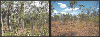
E. tetrodonta pollen is not common but remains represented in LGM samples (Fig. 3b). This species is relatively common in regions with ~700 mm annual rainfall (Boland et al., Reference Boland, Brooker, Chippendale, Hall, Hyland, Johnston, Kleinig, McDonald and Turner2006) with exceptional occurrences down to 500 mm. This does not take into account the effect of either decreased CO2 or temperature during the LGM on species distribution, however these changes act in opposite directions on vegetation. Decreased CO2 is likely to have decreased the competitiveness of woody C3 biomass compared to grass-dominated C4 biomass (Prentice et al., Reference Prentice, Cleator, Huang, Harrison and Roulstone2017). Decreased LGM temperature, the magnitude of which is poorly constrained in the study region (e.g., Cleator et al., Reference Cleator, Harrison, Nichols, Prentice and Roulstone2019) would decrease evaporation and therefore increase effective plant available moisture for a given mean annual rainfall (Liu et al., Reference Liu, Jiang and Lang2018). By combining coastline position and E. tetrodonta rainfall requirements we thus conclude that mean annual rainfall at Girraween Lagoon was most likely in the range 700–1000 mm (Fig. 4).
(color online) Representation of LGM vegetation based on the conclusion of decreased mean annual rainfall at Girraween Lagoon to within 700–1000 mm (annual precipitation derived from the general lower range for Eucalyptus tetrodonta, and the precipitation implied by moving 300 km inland from Darwin today). Reduction in tree cover and stature, loss of woody-plant richness and expansion of grassland relative to current vegetation at the site: left, Girraween Lagoon, August 2018, and right, Jindare Station, September 2015, located within the Northern Territory's 1000 mm isohyet and illustrative of the upper range and conditions at Girraween during the last glacial phase.

Our results are generally consistent with recent modelling results for the LGM globally (Jiang et al., Reference Jiang, Tian, Lang, Kageyama and Ramstein2015) and for the northern Australian region (Yan et al., Reference Yan, Wang, Liu, Zhu, Ning and Cao2018). These studies indicate that there was still an effective monsoon rainfall regime across the northern Australian region, in accordance with earlier studies (e.g. Marshall and Lynch, Reference Marshall and Lynch2008). Yan et al. (Reference Yan, Wang, Liu, Zhu, Ning and Cao2018) conclude that changes in land-sea distribution and east-west gradients in sea surface temperature resulted in a modest lowering of total rainfall but an increase in rainfall seasonality across northern Australia, again in accord with previous studies (Marshall and Lynch, Reference Marshall and Lynch2008). These results suggest that a value towards the lower rainfall boundary suggested above is more likely than the upper rainfall boundary and that the monsoon season duration of 150 days inferred above is more likely an upper boundary.
Jiang et al. (Reference Jiang, Tian, Lang, Kageyama and Ramstein2015) specifically note a lack of correspondence between their modelling results and conclusions based on (very sparse) northern Australian climate proxy records for the LGM. This appears to largely be an artefact of terminology. The LGM coastline was between 200 and 500 km seaward of the modern coastline along the entire length of western northern Australia (Fig. 1), and this means that the change in coastline position will have dramatically decreased precipitation at any terrestrial site simply due to the strong rainfall gradient into the interior. A corollary of this is that monsoon rainfall may not have penetrated far into south-draining catchments, and hence low lake levels are recorded in the arid northern Australian interior at the LGM (e.g., Fitzsimmons et al., Reference Fitzsimmons, Miller, Spooner and Magee2012). So while the modern Australian terrestrial region was more arid at the LGM, this does not imply monsoon failure, but more likely a shift of the majority of monsoon rainfall onto the now-flooded continental shelf. Palynological investigation of deep sea cores between Australia and New Guinea, which therefore were exposed to pollen rain from the exposed continental shelf of Australia, do show an expansion of grassland at the LGM (e.g., van der Kaars, Reference Van der Kaars1991). This suggests that some combination of rainfall amount, seasonality, reduced CO2 and reduced temperature did lead to a general reduction in tree cover over that expected simply from the operation of a continental rainfall gradient similar to that currently observed.
CONCLUSIONS
Girraween Lagoon remained a perennial water body throughout the LGM and as a result retains a proxy record of the LGM environment. The palynological results for the LGM interval indicate a dramatic reduction in tree cover and expansion of grassland relative to current tall woodland vegetation at the site. Dryland vegetation during the LGM interval is best described as an open xerophytic grassy-savanna. In terms of the megabiome classification of Dallmeyer et al. (Reference Dallmeyer, Claussen and Brovkin2019), the site is likely on the boundary between grassland/dry shrubland and savanna/dry woodland. In other DGVM classification schemes the Girraween site is best characterized as close to the boundary of plant functional types variously described as grassland, xerophytic shrubland, grassland/shrubland, and tropical savanna (e.g., Calvo and Prentice, Reference Calvo and Prentice2015).
No inference can be drawn with respect to LGM temperature at the site, but rainfall may be constrained to 700–1000 mm, more likely toward the lower than the upper bound, and wet season length was likely <150 days. The monsoon remained active but most monsoon rainfall fell on the now-flooded continental shelf as a result of a steep rainfall gradient into the continental interior, similar to that which pertains today.
Girraween Lagoon and other permanent water bodies in the Darwin region would have enabled continued human occupation of the area through the LGM, although there is currently no dated evidence of human activity in the region at that time.
ACKNOWLEDGMENTS
This research was funded by the Australian Research Council Centre of Excellence for Australian Biodiversity and Heritage (CE170100015) and an Australian Research Council Laureate Fellowship to M.I.B. (FL140100044). L.H. is recipient of Discovery Project DP130100334. V.L. acknowledges the financial support from the Australian Government for the Centre for Accelerator Science at ANSTO, where the measurements were done, through the National Collaborative Research Infrastructure Strategy (NCRIS), and expresses gratitude to the radiocarbon laboratory staff who processed our samples. Rainy Comley's assistance within the JCU laboratories was greatly appreciated. Warm thanks to the Larrakia Nation, Larrakia Ranger group, and the wider Larrakia community for their support and local insights into the Girraween environment. Access assistance from Graham Churcher is also gratefully acknowledged. Thanks also to Ron Innes for engineering work on the raft and coring equipment. The authors also appreciate the feedback provided by two reviews on earlier drafts.