

Războieni-Cetate offers almost ideal conditions for a new investigation of the site of an ala milliaria, a much-discussed Roman unit of which there were only nine in the whole empire.Footnote 1 A series of factors makes the site particularly interesting for provincial Roman archaeology, especially from the perspective of Roman military history. First, there is no doubt that this was the site of the ala I Batavorum milliaria. It was the only unit at this site, and it was stationed there from the time of Hadrian until the abandonment of the province.Footnote 2 Another defining feature is that more than two-thirds of the fort's area (and the entire northern and western part of the surrounding vicus) has not been built over in modern times and, in principle, remains accessible for research. This makes the cavalry-fort of Războieni-Cetate unique, as most of the buildings and barracks are visible using aerial photography and/or geomagnetic survey: the few hidden buildings, for example, those in the back gardens of the modern settlement, can be easily reconstructed. Finally, the site offers excellent potential for future research, since no excavations have been conducted there apart from two rudimentary sondage excavations in the 1990s.Footnote 3 The only problem at Războieni-Cetate lies in extensive erosion, caused by ongoing agricultural use of the area.
The other identified sites of alae milliariae are almost entirely covered with modern buildings (for example, Heidenheim and Aalen in southern Germany or Stanwix in northwest England). Given these circumstances, Războieni-Cetate is one of the very few forts whose interior layout can be completely recorded. Since the unit that was permanently garrisoned there is also known, the site offers ideal conditions for reconsidering the subject of troop strength and the question of “type” sites; that is, the relationship between fort design and the type of troops assigned, which has been frequently discussed since the work of I. A. Richmond on the subject.Footnote 4 Another important feature is that, contrary to the few other places where alae milliariae are attested, one single unit was garrisoned exclusively at Războieni-Cetate, continuously for about 150 years.
These promising conditions inspired a geomagnetic survey of the fort and the surrounding area. In a joint project between the Friedrich-Alexander University Erlangen (FAU) and the archaeological institute in Iaşi, three campaigns were carried out from 2016 to 2018. With the help of students and early career researchers from Germany and Romania, the entire fort and large parts of the surrounding vicus were surveyed by fluxgate gradiometer.Footnote 5 The campaigns resulted in new insights into the city-like vicus, which contains many stone buildings, and the fort's barracks buildings. The latter work could have far-reaching consequences for our general assessments of barracks construction throughout the Empire, as the stable-barracks discovered at Războieni-Cetate are very different in size and layout from those already explored at other comparable sites.
Subsequently, the geomagnetic features were verified during a two-week excavation in the summer of 2018. In this campaign, conducted by a team from the archaeological institute in Iaşi, the FAU, and the district museum of Alba Iulia, a contubernium consisting of a barrack room (papilio) and an associated stable (stabulum) was investigated.Footnote 6 The results confirmed our assumptions from the geomagnetic survey: at Războieni-Cetate we are dealing with an exceptional type of large barracks, which seems to represent a new kind of “supersized stable-barracks.” This indicates that the prevailing opinion on standardized and typical barracks should be reconsidered,Footnote 7 which will lead to the conclusion that the degree of standardization in military construction should not be overestimated. Despite the high degree of organization displayed by the Roman army, it is always important to take into account the extent and importance of spontaneous improvisation, local characteristics, and individual decision-making.
In the following section, we present some general remarks on the topic of barracks and stables in cavalry forts. We report the results of new research, mainly based on recent excavations at Hadrian's Wall,Footnote 8 and especially on the publication of the excavations at Heidenheim.Footnote 9 We then briefly present the results of the geophysical surveys, which have already been published in German, and of the 2018 excavations.Footnote 10 Finally, we offer some fundamental reconsiderations about stable-barracks in the Roman provinces and the troop strength of alae milliariae.
Stable-barracks of cavalry units in the Roman Empire
Over the last three decades, our knowledge of Roman cavalry forts has increased enormously. After Gustav Müller was able for the first time to clearly identify stables within barracks buildings during this excavations in Dormagen in 1979,Footnote 11 C. Sebastian Sommer in 1995 succeeded in compiling the findings into a new picture that finally solved the longstanding question of where the Roman army kept its horses.Footnote 12 Only since Sommer's breakthrough has it become clear that shared accommodation for horses and men in the same building was the rule. For this now clearly identified type of building Sommer aptly chose the term “Stallbaracke,” translated into English by British archaeologists as “stable-barracks.”Footnote 13
Up until that point generations of archaeologists had searched mostly in vain for stables inside the castra themselves or in the vicinity of the forts.Footnote 14 Simpson and Richmond were on the right track in 1941, but assumed that a discovery at Benwell that suggested joint housing for horses and men, which they linked to the early 20th-c. excavations of a cavalry-fort assigned to the legionary fortress Neuss, was a short-term phenomenon of the Flavian period.Footnote 15 A very useful overview and attempt at a typology of barracks was presented by David Davison in 1989 in three volumes. Although this essential work was published shortly before the now commonly made distinction between cavalry and infantry barracks had been acknowledged, his comprehensive collection of and commentary on all the known auxiliary fort types with their barracks buildings remains an indispensable foundation.Footnote 16 Modern excavation methods and the application of phosphate analyses, which can detect horse urine and therefore the associated cesspits, have added a new perspective. Accordingly, in recent years a large number of Roman auxiliary forts were found to have at least temporarily housed mounted units (alae) or mixed troops (cohortes equitatae). The identification of soakaways for urine has proved to be a decisive criterion. These elongated pits, found in the longitudinal part of the barracks, were used to collect the urine of the horses below the floor level of the stables. Even without phosphate analyses, experience has shown that such soakaways can be identified by the rust-red discoloration of the soil and the objects found in the pits, as well as by lime, used for slaking and binding the urine. Such pits were covered with either planks or stone slabs on which the horses could stand and whose narrow gaps allowed urine to flow downwards.Footnote 17
The question of stable-barracks has been further explored in Great Britain in particular. Virtually perfect examples of this type of construction have been documented in South Shields and in Wallsend.Footnote 18 Along with his exemplary publication of the Wallsend barracks, Nick Hodgson is also to be thanked for the comprehensive collection and documentation of analogies throughout the Roman Empire.Footnote 19 Hodgson and Bidwell subsequently published a foundational article summarizing the now prevailing opinion in this field and attempting to formulate certain basic features of all the stable-barracks documented up to that date.Footnote 20 The state-of-the-art publication of the new excavations in Heidenheim by Markus Scholz confirmed these considerations fully and provided even clearer evidence than the already very significant findings at Wallsend. Furthermore, the fort of Heidenheim offers a special feature: it is the only fortress of an ala milliaria where the barracks area has been extensively excavated.Footnote 21 Excellently preserved features have been discovered recently by the Vindolanda team. The stable-barracks uncovered there in 2017 are quite similar in structure to those from Wallsend but provided an abundance of small finds and organic material, which allowed A. Birley and his team to conclude that having women and children inside the fort was usual practice at Vindolanda.Footnote 22
Accordingly, the following picture presents itself when it comes to the structure of stable-barracks. The barracks contained between 9 and 13 double rooms, comprising one papilio for the soldiers and one stable area each. The average seems to have been ten of these room-units per squadron (turma) (or 13 in the exceptional case of Heidenheim).Footnote 23 Entry into the contubernium was usually via a door in the stable area, and another door led to the living and sleeping area.Footnote 24 The rooms are comparatively small, allowing for three horses in the stables and their riders in the papilo.Footnote 25 This maximum occupancy is primarily calculated on the space required for the horses, which will be discussed in more detail below. This view of standardized stable-barracks with a uniform room design and size has become widely accepted and is considered the mandatory construction method for cavalry forts. That three soldiers and their horses were accommodated in the contubernia of mounted units has thus been established as the dominant opinion in research.
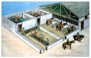
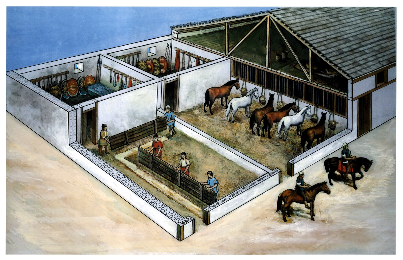
The location of accommodation for the stable boys (calones, with slave status) who belonged to mounted units remains unclear. It is very likely that they were at least partially accommodated in the barracks’ attic, which could also have been used for storing straw (see our suggested reconstruction of a barracks building in Fig. 12).Footnote 26 The practical living conditions in Roman forts (at different periods in history as well as during seasonal use) have also been much debated recently, because research at Vindolanda showed that many more “stakeholders” besides the predictable gregarii took part in the daily life of such a place. Non-male-adult shoes (including very small ones for children), preserved nearly perfectly, and material culture from the contubernia at Vindolanda suggest a very diverse population in the barracks. This makes a case for the poor calones, too, having some place to stay in the fort. It is also not out of the question that Heidenheim (and Aalen) made use of an upper floor with extra rooms, a converted attic, since they were larger double barracks with more extensive foundations.Footnote 27 However, in the absence of evidential features, this is mere speculation.
The living quarters of the soldiers, which are always found in the part of the building behind the stables, can be identified mainly by fireplaces, usually located in the wall facing the stables. Fireplaces often lead to geomagnetic anomalies, can be documented in excavations, and can be used alongside typical ceramics and military objects to draw conclusions about the inhabitants of such a building.
Typically, the barracks are structurally closed off by clearly distinguishable officers’ quarters. These so-called end-buildings (Kopfbauten) are larger apartments in which the decurio and possibly (depending on the barracks design) also the “NCOs” of the ala, were accommodated.Footnote 28 This structure of demarcated officers’ quarters corresponds to that of the well-known infantry barracks found in legionary fortresses and other auxiliary forts that have long been a focus of research. Sometimes there are two end-buildings at each end of the barracks; for example, in Heidenheim, where we can observe double structures.Footnote 29 The end-buildings offered their inhabitants a more comfortable space than the soldiers’ quarters. In addition, the officers apparently had the luxury of their own latrines attached to their apartments.Footnote 30 The end-buildings also most likely accommodated the horses of the officers.Footnote 31
The ala I Batavorum milliaria and the results of the geomagnetic surveys in Războieni-Cetate
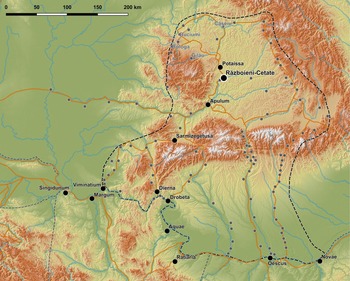
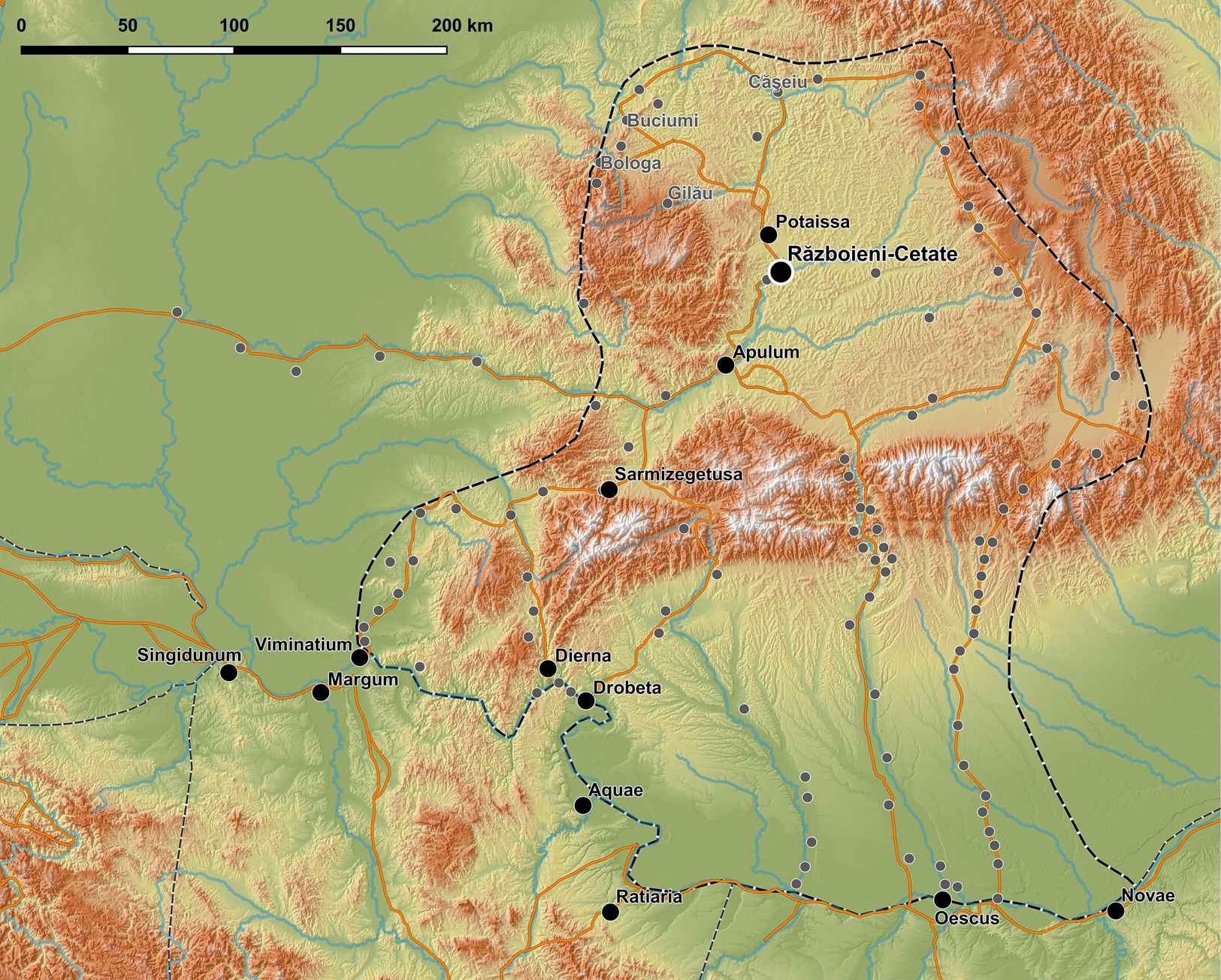
According to the results of the latest investigations, the fort of the ala I Batavorum milliaria in Războieni-Cetate covered an area of 5.2 ha, making it the largest auxiliary fort for one unit in Romania.Footnote 32 The fort is situated between the two legion garrisons in Potaissa/Turda (Legio V Macedonica) and Apulum/Alba Iulia (Legio XIII Gemina), deep in the Limes hinterland (Fig. 1). The basic function of the unit at Războieni-Cetate was presumably to form a strategic reserve and to protect the important salt mines in nearby Salinae/Ocna Mureş.Footnote 33 Thanks to the many bricks bearing the unit's name, as well as an inscription to Hercules Magusanus found on the site in the 19th c., honoring a typical deity of the Batavians, the site can be safely identified as the location of ala I Batavorum milliaria. According to military diplomas, the unit was already present in Dacia Superior by 136 CE at the latest, with Războieni-Cetate as the only reasonable location for it according to the current state of research. Since recently published inscriptions from nearby Potaissa, dated to 253 or 260 CE, still mention the unit, it is likely that it stayed there up to the end of the Roman occupation of Dacia in ca. 275.Footnote 34
Location of Războieni-Cetate and the other forts in Roman Dacia that are mentioned in the article. (Data source: Jarvis et al. Reference Jarvis, Reuter, Nelson and Guevera2008; border of Roman Dacia following Nemeth Reference Nemeth and Rubel2016, 104; illustration by C. Mischka.)
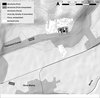
The geomagnetic investigations in 2016–18 not only brought the spatial order and building complexes inside the fort to light, but also revealed the city-like structures of the vicus area to its north and west. Especially along the via decumana and the connected streets to the north, strong anomalies hint at cellars filled with burned debris, while pits or postholes and ditch structures form an array of features which are normally interpreted as “strip houses.”Footnote 35 In addition, the magnetogram shows the foundations of stone buildings, forming complex structures of up to 3,000m2. Similar structures also appear to the northwest and north of the fort. The spatial structure of the vicus resembles a form of linear settlement, its main buildings following the axial road, but combined in this case with the double-row “ring-type,” in which settlements are located along roads that skirt one end of the fort.Footnote 36 The large number of stone buildings and the almost urban agglomeration of structures to the north of the fort, which can be interpreted as public buildings, were striking (Fig. 2). Nevertheless, further measurements would be needed to augment this interpretation, as large parts of the vicus's north remain unsurveyed.Footnote 37
Războieni-Cetate: topographical setting, surveyed areas, and comprehensive archaeological structures. (Data source: Jarvis et al. Reference Jarvis, Reuter, Nelson and Guevera2008; map data © OpenStreetMap contributors: https://www.openstreetmap.org; illustration by C. Mischka).

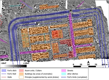
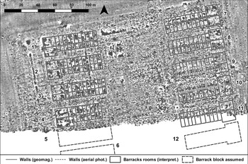
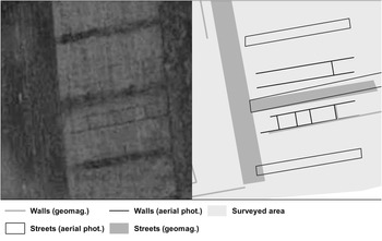
The geomagnetic survey of the fort area showed the typical building structures of Roman forts. The principia and praetorium are clearly visible, as is another building on the central axis of the via principalis (possibly a fabrica or horreum). The intensive agricultural use of the site means that the state of preservation is rather poor. For the most part, only the ditches of the foundation walls are still visible as geomagnetic anomalies. A somewhat clearer picture emerges of the nine barracks which have been documented, to which three more in the southern part of the fort, which could not be surveyed due to modern obstructions, can safely be added. Two buildings in the eastern part of the fort are comparatively well preserved and can also be seen, complete with the interior room layout shown in aerial photography (Fig. 6).
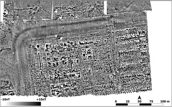
The geomagnetic survey (Fig. 3) shows numerous strong dipoles, which can be traced back to furnaces or fireplaces and, in the stables, to the iron precipitation formed in pits by horse urine and soil moisture. In addition, there are extensive anomalies and isolated traces of walls. However, the features are too ambiguous for a clear division of the spatial units or even of the building outlines. In most cases, the end-buildings are best delimited as planar areas of geomagnetic anomalies. They consist of two room-units each, whose dividing structure, be it the remainder of a wall or a foundation ditch, separated the whole northern part of the building from its southern part longitudinally in almost all of the barracks (see, for example, Fig. 4).
Războieni-Cetate: magnetogram of the fort's area. (Illustration by C. Mischka.)

Războieni-Cetate: magnetogram with archaeological interpretation. (Illustration by C. Mischka.)
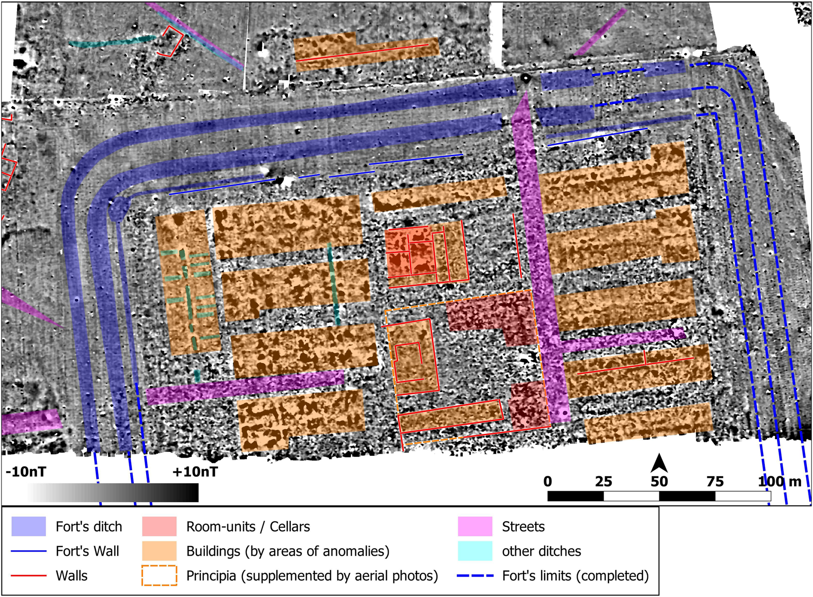
More problematic is the subdivision of the barracks into individual compartments of contubernia based on the results of the geomagnetic survey alone. There are hardly any clear wall structures visible in the survey, and the only other indicators for the boundaries of the room-units – areal, rectangular anomalies – do not give a clearcut picture; their distribution is neither equidistant nor sufficiently homogenous. This is not necessarily the result of lack of accuracy of the gradiometry nor of an intensive displacement of underground structures by agricultural activity.Footnote 38 The outcome is that it is not possible to draw a plan of the internal division of the barracks based solely on the geomagnetic results. For this reason, aerial photography was additionally used for reconstruction. Fortunately, the middle part of the barracks, revealing the best picture in the gradiometry (Fig. 5, no. 10), is also captured optimally in an aerial photo. Its outline and inner divisions are defined by cropmarks, exactly matching the walls derived from the gradiometry. The photo shows the complete internal structure, where the geomagnetic result only shows one clear interior wall, the only wall that seems to have been built as massively as the exterior walls.Footnote 39 This combination of methods provides the basis for further interpretation of the structure of the fort.
Războieni-Cetate: magnetogram with reconstruction of the barracks’ interior layout. (Illustration by C. Mischka.)
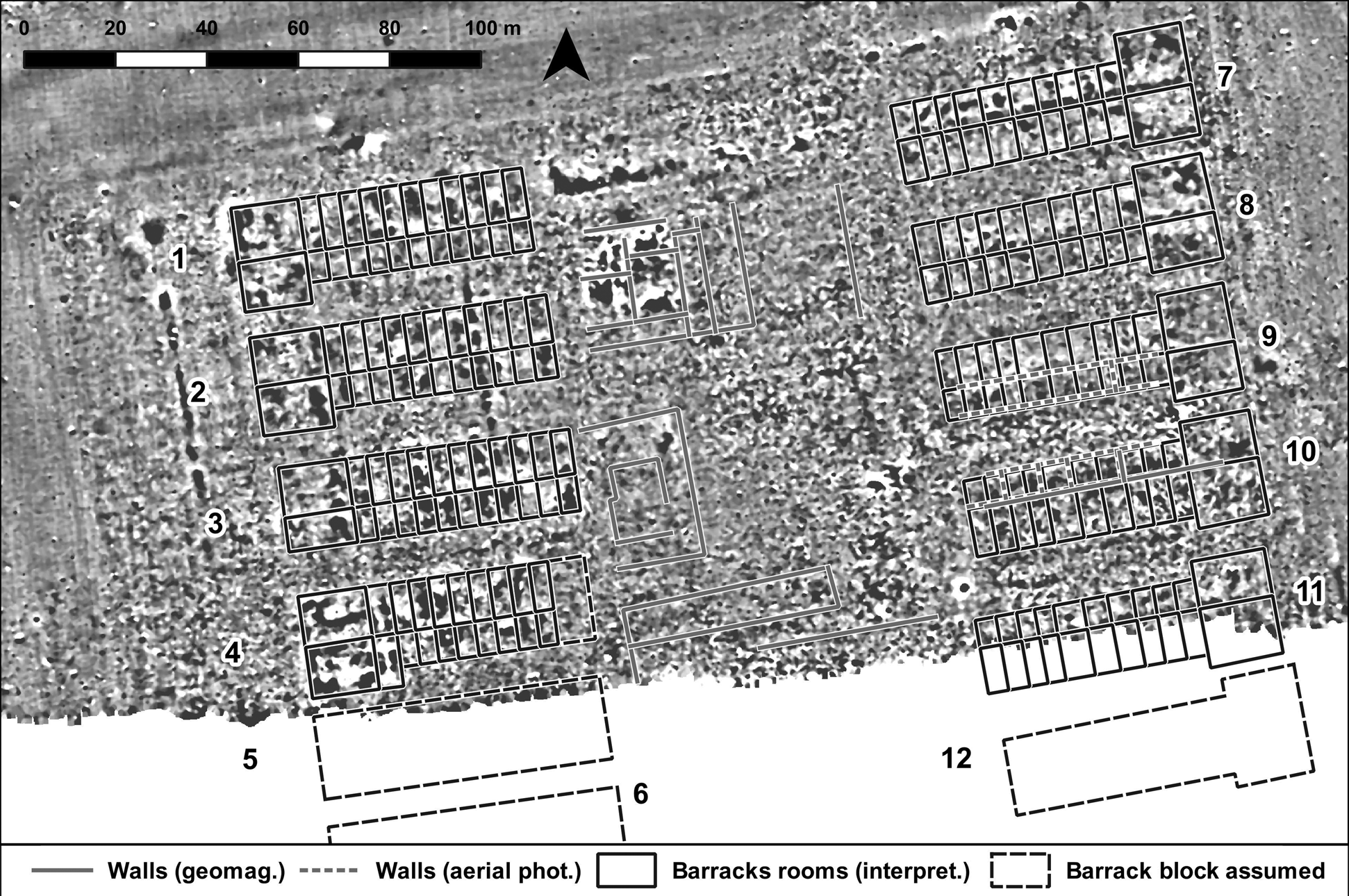
This process produced the following results. In the men's section of the buildings,Footnote 40 which are best preserved in both the gradiometry and the aerial photography, we find ten rooms (papilio), plus two further room-units in the end-buildings. The width of the compartments, which can be derived from the aerial photography, is between 4.0 and 6.5 m, resulting in an average width of 4.6 m where the several consecutive partition walls have been interpolated. This reconstruction of the layout of the rooms, initially based purely on geometrical principles, conforms very well to the shape of the geomagnetic anomalies. The implication is that the model corresponds sufficiently closely to actual historical conditions. In the next stage of analysis, the model room plan was transferred to the remaining barracks in the western part. Here, too, the proposed room layout conformed well to the geomagnetic anomalies. Where there were clear overlaps with strong geomagnetic anomalies, the partition walls appear slightly shifted in our drawing.Footnote 41 The end-buildings, however, seem to have been constructed on more individual plans. Since only the outer boundaries and the longitudinal axes of the buildings could be incorporated into the drawing, the geomagnetic survey is reliable enough for an interpretation of the features and the building structures. The barracks in the western part of the site were then reconstructed by analogy, since the walls and especially the interior divisions here were much less well preserved or visible in geomagnetic anomalies than in the eastern part.
As a result, it was possible to fit ten compartments into each of the three best-preserved barrack blocks in the eastern part, each about 5 m wide, and this hypothesis is backed up by both the geomagnetic anomalies and the aerial photographs (Fig. 6). The length of the three eastern barrack blocks (counting only the cavalrymen's stable-barracks, and not the end-buildings), which are entirely visible and were captured in the geomagnetic survey, is about 49.5–50 m. The overall length of the barracks (roughly 65m) falls within the norm for both legionary and auxiliary barracks of the 2nd and 3rd c. CE. The shortest legionary barracks are about 50 m long, and the longest auxiliary barracks are also around the 50 m mark. These are therefore exceptionally long buildings for an auxiliary fort compared to Davison's results.Footnote 42
Războieni-Cetate: aerial photographs (left) and combined structures from geomagnetic survey and aerial photography (right). (Aerial photographs: Google Earth Pro V 7.3.2.5491 (26 May 2011). Razboieni-Cetate, Romania. 34TGS197784908. Altitude: 1.3 km CNES/Airbus 2018. http://www.earth.google.com [11.09.2018]; illustration by C. Mischka.)

In addition to the nine barracks captured in the geomagnetic survey, three more can be safely added due to the assumed symmetry of the fort. Thus, 240 compartments overall were available for the inhabitants of the fort – men and horses – not including the command personnel, who used the end-buildings. The average size of a compartment was 43.1 m2, and that of a room-unit in the end-buildings was about 173.7 m2. Thus, it is evident that the dimensions of the compartments differ significantly from those of the much smaller accommodation units and stables known from auxiliary forts in the rest of the Empire. This is naturally only a very schematic proposal since we need to take into account the challenges of practical “daily life” at the fort. Many soldiers had probably been detached to other missions, as we know from papyri and the tablets from Hadrian's Wall, while perhaps soldiers’ families and other dependents lived for some of the time, temporarily at least, inside forts, as at Vindolanda.Footnote 43
In comparison to Heidenheim,Footnote 44 the barracks at Războieni-Cetate lack any axial symmetry. At least, this is true of the barracks in the eastern part of the fort, which are sufficiently well defined in the features that were surveyed. Even in the western barracks, as far as we can tell from the remains of the partition walls between the northern and southern parts, the rows of compartments have different lengths. For example, in building no. 10 (Fig. 5), the rooms in the south are 10 m in length, but in the north, they are only 6.6 m long. This cannot be explained by the imprecision of geomagnetic detection since the barrack block itself is very clearly visible. In addition, an aerial photograph is available and shows the same strikingly narrow north wing of the building (Fig. 6).
The different halves of the barrack blocks reveal a clearly bimodal distribution in the sizes of the men's quarters (Fig. 7) that is highly unusual and requires explanation. At this point, it seems easiest to assume that the larger building wings corresponded to the stable areas and the smaller ones to the quarters of the soldiers. This prediction was confirmed by the 2018 excavations (see below). An allocation of one turma per section of the building seems improbable since even if the individual room-units had been additionally divided into a horse and a crew area by further, less stable partition walls that might be invisible in the gradiometry, there would still have been a disproportion (25 m2 compared to 69 m2 at the extremes) between the sizes of the individual rooms.
Războieni-Cetate: frequency (n) of room sizes (m2) in the barracks (without head building). (Illustration by C. Mischka.)

It is much more likely that two turmae shared one barrack block, with the men of both units on one side of the barracks and their horses on the other (five stables per unit, with associated end-building for the commander). Only the division of the end-buildings would then have corresponded to the otherwise usual layout. The bimodal distribution of the room sizes would thus be explained by the difference between crew and stable areas. Thus, for two turmae garrisoned in one barracks, the room sizes would be much more homogeneous, as the average size of soldiers’ rooms would then have been 34.3 m2 and of stables, 48 m2.Footnote 45 According to this solution, one would only have to accept a higher occupancy rate in the individual rooms of six to eight men (for troop strength of the ala milliaria, see below). The rooms are, however, still considerably larger than those in the barracks in forts on Hadrian's Wall and at Heidenheim.Footnote 46 The generous length of the men's part of the barracks therefore means that the size of each papilio, at 34.3 m2 (average), was bigger than was usual for fortresses and forts. In fact, it is at the top end of the full range: sizes vary greatly, but 25m2 is generally said to be the typical area.Footnote 47
As a consequence, it soon becomes clear that the barracks structures we were able to reconstruct by combining aerial photography and gradiometry were very different to those of other cavalry forts. Both the horsemen's barracks in Great Britain and elsewhere, described in detail by Hodgson and Bidwell,Footnote 48 and the features from Heidenheim excavated by Scholz,Footnote 49 clearly housed smaller units (Fig. 7). The exceptional element of the buildings at Războieni-Cetate is the size of the men's section of the accommodation, with its ten large contubernia. Since the results of our survey practically exclude a double structure of smaller contubernia, such as in Heidenheim, we can assume that Războieni-Cetate deviates considerably from the known pattern of barracks buildings. In view of the average stable size of approximately 50 m2 and at most almost 69 m2, and the very generous crew compartments of about 35 m2 on average, the Romanian stable-barracks might be called “mega stable-barracks.”Footnote 50 They certainly appear to be supersized compared to the interior design of all other known stable-barracks.
Contrary to the usual assumption of an occupancy of three people per room,Footnote 51 at Războieni-Cetate it would have been easy to fit six to eight men in the papilio with their horses in the larger stable section. This feature, if it is confirmed by excavations, can be seen as a further indication that the Roman military had a less uniform structure than is often assumed (often for the sake of systematizing simplicity). At the very least, the findings suggest that there was a variety of different concepts of organization. To make this observation, it is not necessary to compare very distant regions such as Britannia and Dacia: even the structure of the barracks in Heidenheim could, according to M. Scholz, represent “a very Raetian solution,” different from neighboring Germania Superior.Footnote 52 The barracks of the cavalry fort of Welzheim (Rems-Murr-Kreis / D), for example, only 50 km from Aalen (Ostalbkreis / D) on the southern Upper Germanic Limes, reveal completely different structures from those in Heidenheim.Footnote 53 We conclude that the dominant view of stable-barracks as typically constructed according to the same pattern (by the book, with a blueprint) must now be reconsidered.
The unusual size of the compartments, as well as those already described with quite clearly visible irregular spatial division and no axial symmetry, led Nick Hodgson to express doubts about the correct interpretation of the survey, suggesting that one could instead see double structures and additional separating walls in the findings (as at Heidenheim).Footnote 54 In fact, the technical accuracy of the survey was always guaranteed (and thus the quality of the geomagnetic survey) and our reading and interpretation of the results of the gradiometer prospection was fully supported by the aerial photography. Nevertheless, due to the fundamental importance of the features and to clarify the question of whether Războieni-Cetate really did contain a new, previously unknown type of “supersized” or “mega-stable-barracks,” an excavation was required.
Results of the excavation 2018
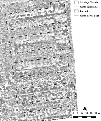
Against this background, excavation work was carried out in the summer of 2018 to record the personnel and stable parts of one of the barrack blocks with trial trenches. Barrack block No. 10 in the eastern part of the fort seemed particularly suitable for confirming or refuting the geomagnetic features because the structures and room layout were most clearly visible in the geomagnetic survey as well as in the aerial photographs.
Unfortunately, the area where the aerial photography is clearest was not accessible due to the state of field cultivation. However, it was possible to open a series of trenches in a neighboring plot, just 18 m to the west (see Fig. 8). Under the direction of Alexander Rubel, excavation work was started on 17 July 2018 and scheduled for two weeks. The National Museum of Alba Iulia, represented by George Bounegru, has responsibility for this site.Footnote 55
Războieni-Cetate: detail of the magnetogram with archaeological interpretation including marked location of the 2018 sondage trenches. (Illustration by C. Mischka.)

The work pursued two main objectives. The first was to see to what extent the survey results were representative of the actual structures in the soil. For example, it was necessary to clarify if there were other, smaller subdivisions of the compartments that had been invisible in the surveys. These would render the hypothesis of “supersized stable-barracks” untenable. The second goal of the campaign was to review the interpretation of the building phases that was based on the results of the 1990s trial excavations and to deliver the most precise chronological data possible. Here, it was of special interest to identify and separate possible stone and timber construction phases. In fact, by carefully locating the trenches based on the prospection results, it was possible to obtain maximum information with limited personnel and financial resources.
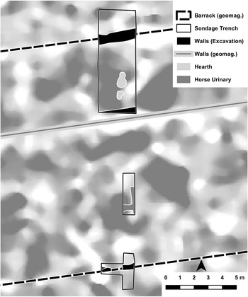
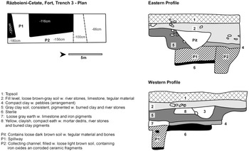
In Area 1, 30 cm below the surface, the foundations of the northern wall and of the dividing wall between the northern and southern parts of the barracks were uncovered, both around 40 cm deep and made up of limestone blocks (Fig. 9). Traces of a wooden construction phase were also visible in some places at the bottom of the stone foundations.
Războieni-Cetate: archaeological structures from the 2018 sondage trenches, indicating fireplaces of the two timber phases in the papilio. (Illustration by C. Mischka.)
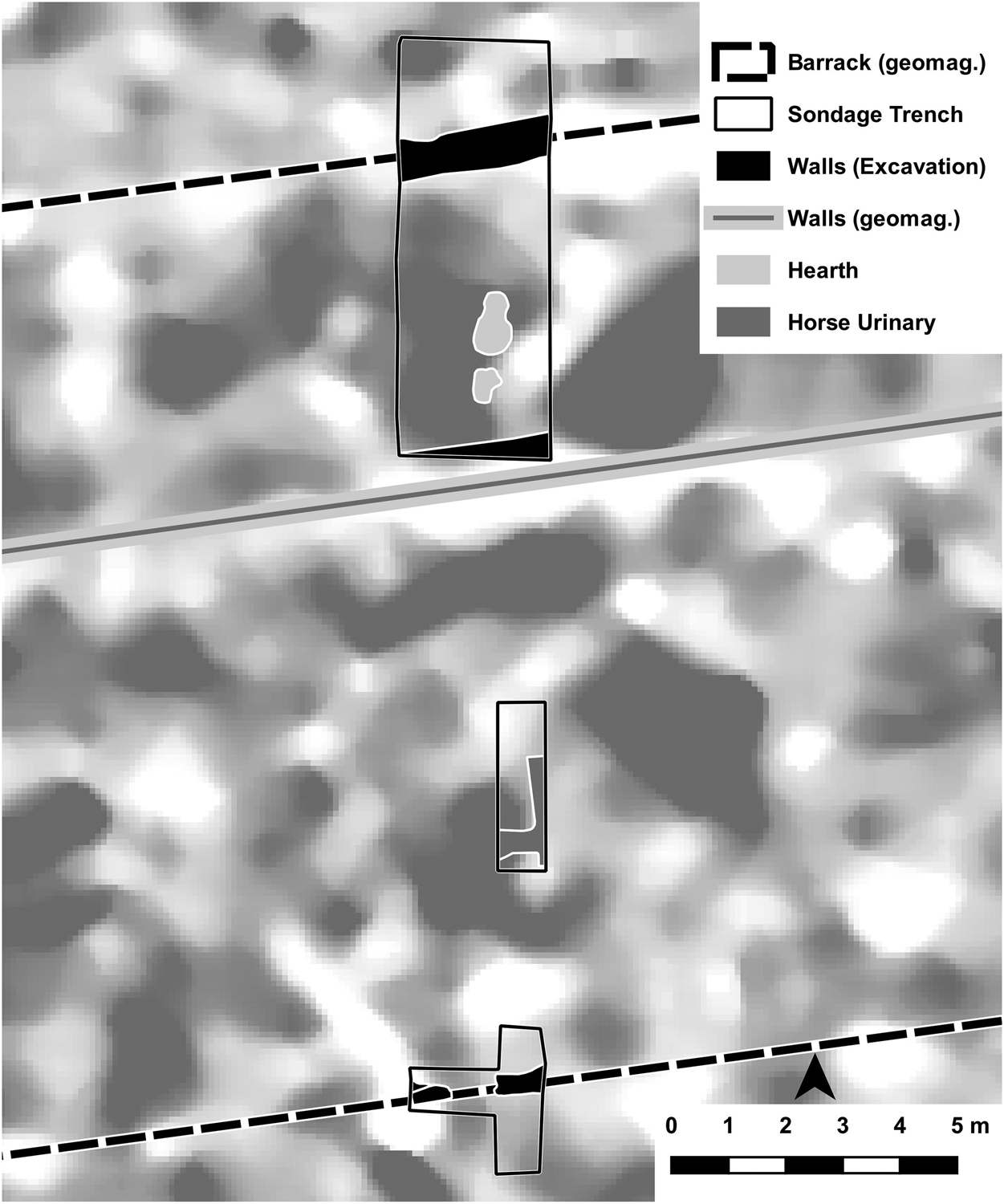
Within this walled area, the interior of the building revealed at least three occupancy phases. At the bottom, a hearth was found, together with the remains of a wattle and daub wall at the edge of the trenches. This wall presumably divided the area from the next compartment to the east, which was not included in the preliminary excavations. A further hearth above this discovery could be connected to the remains of a clay floor (Fig. 9). These remains, in turn, are separated by a levelling layer, containing numerous fragments of charcoal and red clay, from a second floor, which marks the third and final phase of the barracks’ construction.
There was no evidence of a change in the compartment's size or layout in the different phases, and this stratigraphy can easily be compared to the earlier results.Footnote 56 The small finds in Area 1 – iron projectile points, remains of a hand mill (similar to a feature in South ShieldsFootnote 57), a large number of caligae nails, as well as waste pits and the hearths – show that this part of the building was, as already assumed based on the survey, a compartment for the accommodation of soldiers.
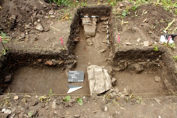
Two further trenches were dug in the southern part of the building. Like the first trenches, these did not show any indication of a further subdivision of the compartments. The southernmost trench covered the southern wall of the barracks. A special feature of the wall was the entrance, where a flat block of limestone measuring about 50 x 40 cm was used as a threshold (Fig. 10). This opening is too narrow for horses but certainly suitable as a secondary entrance for humans. That this part of the building functioned as a stable is shown clearly – even more so than the northern part's use as functional living quarters – by the third trench, located between the first two excavated areas. Two distinct, 50 cm-deep gullies meet at right angles beneath the floor level of the barracks. Analogous to finds from other cavalry forts, these gullies can be interpreted as collection and drainage channels for horse urine. A special feature, which has not been found in other stable-barracks thus far, is the use of a multi-stage drainage system with collection channels of different depths. In the small trench, a deeper main channel and an inflow channel dug at a 90° angle to it were found (Fig. 11). This interpretation is also supported by the exceptionally poor state of preservation of the ceramic material, which is presumably due to uric acid.
Războieni-Cetate: entrance to the stable compartment in Sondage 4. (Photo by J. Lopez.)

Războieni-Cetate: The urine pit of the stable marked by a multi-stage drainage system with collection channels. (Illustration by L. Grumeza.)

Războieni-Cetate: reconstruction of a barrack block. (Illustration by Romeo Ionescu, inspired by a drawing by Peter Connolly [Connolly Reference Connolly2010, 17].)
Overall, the 2018 excavation thus confirms the multi-phase nature of the fort observed in the first estimates of 1995–2000. The material discovered in the excavation – in particular, pottery, coins, and stamped bricks – allows more precise dating, although that is not the subject of this paper. In addition, the campaign's results support hypotheses that were formerly based only on the different survey methods’ results. It turns out that well-founded and detailed interpretations of the interior arrangement can be derived from gradiometry and aerial photography features, even if ground-truthing by excavation, at least of a sample, remains necessary.
The stable-barracks in Războieni-Cetate may therefore be referred to as “supersized stable-barracks.” As such, they are so far unique for the Roman Empire in their layout and design. Certain consequences result from this. Once again, the variety of Roman military infrastructure is demonstrated, as Davison was able to show in 1989 with his survey of auxiliary barracks all over the Empire. In general, the results also show that there could not have been strict building regulations that determined the planning of forts down to the last detail throughout the Roman Empire.Footnote 58 Despite all the comparability and standardization of Roman military architecture, there was obviously plenty of scope for detailed solutions or special features in the construction of Roman forts, which, at the same time, did not compromise the overall design. In view of these new results from Transylvania, we will have to move away from the idea that stable-barracks were generally built on the principle of accommodating three riders and their horses at a time.
Some considerations regarding the troop strength of alae milliariae and types of stable-barracks
With this new, comprehensive data from a clearly identified and accessible site of an ala milliaria, we should reopen the question of the troop strength of these units, as well as the issue of so-called “type sites,” that is, drawing conclusions from the outline of Roman forts about the types of units which probably inhabited them.Footnote 59
The problem of the actual troop strength of an ala milliaria is well known and unresolved. We cannot propose here a completely new solution based on these results and on data recovered since A. von Domaszewski and G. L. Cheesman dealt with the problem. We can, however, reassess the general issue in the light of the size of the barracks discovered at the forts of attested alae milliariae at Heidenheim and at Războieni-Cetate.Footnote 60 The truth is that our written sources are quite contradictory. One must combine statements by Pseudo-Hyginus with accounts by Arrian and Vegetius to get a more or less coherent picture, which unfortunately still leaves some gaps to fill using intellectual acrobatics. The classification of this type of auxiliary unit as milliaria seems to lead in the right direction: the unit's strength should be 1,000. Indeed, Pseudo-Hyginus speaks of a thousand members in this kind of unit, but he speaks of horses not of men.Footnote 61 Assuming that these horses also have riders, even though we know that Roman military units were rarely at full strength, one would conclude that an ala milliaria would have roughly 1,000 troopers. But the same Pseudo-Hyginus (De Mun. Castr. 27) tells us indirectly that the operative subunits, the turmae, had 30 troopers, and from Vegetius (2.14) we know that in each ala quingenaria (the ‟500-man” ala, which is usually believed to contain 512 soldiers; Arr. Tact. 18) we would find 16 turmae, while the alae milliariae would have just 24 turmae (and not 32 as one would suppose arithmetically). Arrian (Tact.18) and Vegetius (2.14) also hold that 32 troopers made up a turma. But as these ancient authors do not specify whether or not the two non-commissioned officers of a turma, the duplicarius and the sesquiplicarius, would also be ranked among the aforementioned 32 men in a squadron, the notional strength of a turma could also be 30 men, as per Pseudo-Hyginus. This would make 768 (720) troopers, to which we must add 24 decuriones (and eventually 48 NCOs), thus, there would be, overall, nearly 800 men by this count. Some hold that this calculation based on the written sources is at best imprecise and vague, if not wrong. They propose that 40 or 42 troopers would serve in each turma of an ala milliaria. After all, such a prestigious unit would need more soldiers in each squadron to match the notional troop strength of 1,000 men.Footnote 62 An argument in favor of this view, one supported by a consistent minority of scholars, could be that, otherwise, the difference between a cohors quingenaria equitata containing about 620 men and the far more prestigious ala milliaria would be rather insignificant.
Since the ala milliaria was the most prestigious of all the auxiliary units of the Empire, one could imagine that the turmae of these units would have more soldiers than ordinary ones. Nevertheless, most scholars stick to the explicitly mentioned 30/32 men for each squadron. This figure is also confirmed by papyrology: the effective strength of a turma was recorded in Britain, with the Vindolanda writing tablets listing provisions for about 27–30 troops, and also in Egypt, with a papyrus confirming a shipment of hay for 31 cavalrymen.Footnote 63 Taking the ancient accounts seriously, we would have alae milliariae that are milliariae only in name and feature fewer than 800 soldiers, or we propose larger squadrons of 40/42 men for the milliariae by conjecture to get the full 1,000. As we have seen, the exceptional aspect of the barracks buildings is the size of the men's section of the accommodation, with its ten large contubernia, which probably indicates that it was designed to meet a special need. It is tempting to suggest that this could relate to a larger turma size of 40/42 for the milliaria garrison. Each contubernium would provide space for eight troopers, with plenty of room in the stables for eight to ten mounts. The matter does not get any clearer if we remember that Pseudo-Hyginus speaks explicitly of 1,000 horses. From his account (De Mun. Castr. 16) we know that every decurio had two remounts and each NCO one, and these 96 remounts are explicitly excluded from the overall count (which would be 1,096 horses altogether). As Junkelmann reasonably argues, we must also think of several remounts for each unit, as illness, injuries, and deaths in battle of horses could otherwise affect the performance of the ala. On the other hand, papyrus accounts from Dura Europos describe the case of a mounted unit with exactly one horse per trooper. This source also lists some troopers who lost their mounts and were still without replacements, as well as describing an earlier acquisition of comparatively old horses as substitutes for casualties, which suggests that the supply of remounts was less than optimal.Footnote 64
Thus, about 800 troopers would have had 1,000 horses or more at hand – and many more, if we also take packhorses into account.Footnote 65 This must be kept in mind as we analyze the necessary space for horses and men in forts (and outside them, insofar as horses are concerned). If we now take a closer look at Războieni-Cetate, we might shed some more light on this rather shadowy issue.
Space requirements of men and horses
It is possible that by considering the space requirements of horses and humans, some additional arguments for determining the troop strength of a unit may be provided.
First let us consider the animals. Today it is forbidden in most European countries to keep horses tethered because it is not compatible with modern ideas of animal protection (in Germany this is regulated at state level via §2 of the Animal Protection Act and tethering has been forbidden in all federal states since 2014).Footnote 66 This is not true of Britain, but there are discussions in Parliament, most recently about amending the Animal Welfare Act of 2006 in order to forbid tethering (debate in the House of Commons, 20 February 2019).Footnote 67 Permanently tethering animals next to each other at night, however, usually separated by wooden partitions in a confined space, was the rule in earlier times. As late as the middle of the 20th c., a stance width of 1.6 m per horse was recommended in the relevant technical literature.Footnote 68 Tethering was not regarded as problematic until well into the 20th c., when horses were used intensively for work. Even from today's point of view it should not necessarily be interpreted as a past lack of sensitivity about animal protection or the result of insufficient space. The animals had adequate exercise under the quite strenuous conditions of their use, so this form of accommodation did not lead to (further) negative effects on the wellbeing of the animals. Interestingly, we also find relevant exceptions in animal protection regulations in the present. For example, the temporary tethering of horses during military operations in Switzerland is expressly permitted as an exception to the Animal Protection Ordinance (Art. 59 § 1 TSchV).Footnote 69
Modern guidelines for the accommodation of horses, which prescribe or recommend a space of about twice the shoulder height of the horse in square meters,Footnote 70 are a poor guide to ancient conditions. Animal welfare considerations, in the modern sense, played no role in the Roman army. Moreover, Roman military horses enjoyed far more exercise than their modern counterparts, which are mainly used for occasional leisure sports and are relatively less worked. Roman horses were also considerably smaller than today's mounts, and with a height of about 1.40 m, they were at least 30 cm shorter.Footnote 71 Compartments used for stabling were also historically much smaller. In the 1700s, horses in the princely stables in Bayreuth (Bavaria), the noblest and best cared-for animals, were stabled, tied up in pitches of about 4.5 m2 separated by half-height partition walls of 1.80–2.50 m.Footnote 72 In the agricultural sector, even less space was provided for tethering than for the princely horses, which were maintained at great expense.Footnote 73 Even if generous stabling of the horses was assumed for Războieni-Cetate, by analogy with the model of an early modern princely court, six horses could easily have been kept in the stables of these stable-barracks, which measure about 11 m in length and extend on average to about 48 m2. If eight horses were permanently accommodated in these stables, each would still have a space about 1.35 m wide at its disposal. Under these conditions, and without animal protection laws, it would have been easily possible to fit ten horses into the very large stables at Războieni-Cetate. This corresponds approximately to the width of the interior of a modern horse trailer for cars, suitable for the transport of one animal and undoubtedly sufficient for the much smaller horses of the Roman period.
Now let us consider the requirements of the cavalrymen. Depending on the assumed troop strength of an ala milliaria (720 or 768, NCOs included, with 30/32 men for each turma, or 960 or 1,008 respectively if there were 40/42 riders per turma), the men's quarters would have had to accommodate six or eight men each. Either possibility is easily imaginable. The infantrymen of the legionary fortresses and the auxiliary cohorts had to share much more cramped quarters. According to the space and area norms of the German Army, the Bundeswehr, a soldier is entitled to 4.5 m2 of living space in shared accommodation, and from NCO rank upwards, there is a claim to single rooms of 13.5 m2.Footnote 74 The allocated space for a Bundeswehr private seems to be similar or even smaller than for riders of the auxiliary troops in Războieni-Cetate, who had about 4.5 m2 per man available for a room occupancy of eight men, and as much as 6 m2 for the more likely occupancy of six. However, the cavalry soldiers probably also had to accommodate equipment in their quarters, while at infantry fortresses, it was stored in antechambers (arma) or separate armories (armamentaria managed by a custos armorum). Therefore, it is not possible to conclude from the size of the rooms in the crew quarters whether eight or only six men had to share a room, and thus the required troop strength could have been about 1,000 or only about 800 men. The old question of whether we should rely more on the account of the ancient sources or if we should accept von Domaszewski's conjecture cannot be decided by reflections on type sites and barracks structures, even if Războieni-Cetate would evidently be the perfect site for such a task.
The need to accommodate significantly more horses than men, however, makes it in our view more likely that the usual strength of an ala milliaria was fewer than 800 men, especially taking into account the higher number of remounts and packhorses that recent research suggests.Footnote 75 In Războieni-Cetate it would be quite possible to accommodate more than six or seven horses in the stable compartments. There is a strong case for assuming a target of around 800 men for an ala milliaria divided into 24 turmae, rather than assuming 1,000 riders. Accordingly, a turma would always be a unit of 30 or 32 men, regardless of whether the squadron was part of an ordinary cavalry unit or an ala milliaria. After adding remounts and packhorses, many more animals had to be stabled than just the soldiers’ mounts. Since this cannot have been possible in the stable area inside the barracks, we must assume that further animals (possibly in rotation) were housed on the fort's prata or in additional stable buildings in or near the fort. We might consider this function for one or more of the castrum's non-barracks buildings. A large structure in the northwestern corner is a possible candidate, as well as a long, narrow building in the north, near to the porta principalis sinistra. Even a more rudimentary building visible in front of the castrum's northern ditches could be interpreted in this way. But as our picture is nearly exclusively derived from non-invasive survey, this must remain pure speculation.
On the other hand, if Hodgson is right and separate stables are “now known to be a myth” in the wake of the new assessment of billeting troops and horses,Footnote 76 we must put more horses into the stable-barracks than men. In that case, a ratio of seven or eight horses and a contubernium of six troopers, quartered in the barracks’ rear parts, appears to be a reasonable guess.Footnote 77 If one now wants to allocate the men of the Batavian ala sensibly across the 12 barracks – the nine documented double barracks and the three it is necessary to add – it seems much more logical to assign a company of two turmae, totaling about 60 men, each with at least 60–80 horses, plus officers with their mounts (the two decuriones of such a double barracks had three horses each, the four NCOs had two each, and at least the animals of the high officers were probably accommodated in stable compartments of the end-buildings).
In any case, the layout of the fort at Războieni-Cetate fits the requirements of the milliaria unit exactly. With 12 supersized stable-barracks buildings and the usual facilities of a typical “by the book” fort, it would be a perfect type site for an ala milliaria (to the extent that only very few sites are known that could be associated with the garrisoned troops from written sources). But our case also shows the limits of associating the sizes and layouts of Roman forts with certain types of units. In fact, the results of our research can provide new insights into the matter of the so-called type sites to only a very limited extent. The identification of stable-barracks in Roman forts is itself, of course, a step forward, because at least for certain phases, the stationing of mounted or partly mounted units can be safely assumed when identifying stable-barracks.
Given the variability of Roman military architecture, it remains largely speculative and not very helpful to assign units to specific locations without written sources or epigraphic data. In the case of Războieni-Cetate, the facts are fortunately very easy to determine due to the availability of a range of different sources. In addition, the fort's layout fits perfectly (as at Heidenheim and Aalen) with the unit that was known to be stationed there throughout the existence of the province of Dacia. At other locations, where several different units could be accommodated at different times, only the determination of infantry barracks alone, without stable compartments, can allow a clear assignment to cohortes or numeri (depending on the size of the fort), although this approach rarely yields much. Against this background, the identification of “type sites” seems to be a futile endeavor.
Stable-barracks in Roman forts and the problem of identifying the garrisoned troops
Based on the facts presented here, it should have become clear that a standardized construction for stable-barracks in cavalry forts cannot be assumed. The sheer number of variants of barracks buildings with different dimensions that Davison meticulously compiled already pointed to the conclusion at which we have also arrived.Footnote 78 Although there were certain basic principles of fort construction in terms of construction techniques and fundamental structure, individual, detailed solutions were apparently possible, and in fact customary, within this framework. Thus, as is well known, more or fewer than the ideal ten compartments per barracks could be built, and various forms of end-buildings for officers’ quarters could be included.
The once widely accepted assumption that there was a standardized room layout for stable-barracks, designed for three men and their horses, was based on observations from excavations of the last two decades at about ten sites where stable-barracks and a small-scale room layout are documented or very likely.Footnote 79 According to this view, the results from Războieni-Cetate would be an exceptional case. However, a review of the results of older excavations may find further grounds for comparison. This cannot be done at this point, but a few examples, especially from Hadrian's Wall, do catch the eye. The similarity of the stable-barracks at Războieni-Cetate to a barrack block at the fort at Benwell near Newcastle, excavated at the beginning of the 20th c., is particularly intriguing: in its ground plan, apart from the fact that only nine spatial units were counted, it looks almost like a blueprint of the Romanian features (Fig. 4), except that the size of the Benwell barracks is smaller. The overall length of the buildings in Transylvania is greater, at 64.5 m compared to 45 m. Since a cohors milliaria equitata has been documented for Benwell (RIB 1328) and the excavators already argued convincingly that part of the cavalry troops of the unit must have been accommodated in the retentura,Footnote 80 it is obvious this site had a stable-barracks structure, an observation that was overlooked at that time. Interestingly, the excavators had already discussed this question on the basis of comparable finds from Neuss but had excluded the joint accommodation of riders and horses as a feature of army forts for troops on campaign or, at best, dismissed them as part of a very early construction phase of 1st c. castra, excluded for the 2nd c. and later.
Taylor already remarked that the barracks in the forts at Hadrian's Wall, which were likely occupied by mounted units, have contubernia with a greater room-width than those used by the infantry.Footnote 81 This observation might indicate that a more generous design was required for equestrian barracks because of the incorporated stables. In view of the results presented here, a new look at older excavations could perhaps lead to a re-evaluation, so that further analogies to the features in Războieni-Cetate can be identified. This project is, however, beyond the scope of this paper.
Other forts in Dacia
Finally, let us look at the surroundings of the fort of Războieni-Cetate. Although only a few regional peculiarities and similarities in the construction of forts can be found throughout the Empire, the question of whether or not other Dacian sites present similar features to those observed at Războieni-Cetate should briefly be explored (Fig. 1). Like the possible “Raetian peculiarities” assumed by Scholz, “Dacian peculiarities” could theoretically also be responsible for the findings in Războieni-Cetate. Here, we will refer to the unpublished doctoral thesis of I. Socol, devoted to the barracks in Dacian forts.Footnote 82 Among the ten Dacian forts Socol investigated, there are more differences than similarities. The examples in Dacia can easily be placed in the typology developed by Davison, but barracks structures comparable with Războieni-Cetate have not been documented. In two castra (Bologa and Buciumi), Socol has identified double barracks that are not comparable with the features of Războieni-Cetate.Footnote 83
Socol also, however, points to the probable existence of stable-barracks in Dacia that are yet to be identified.Footnote 84 As far as we can see, the late D. Isac, to whose work Socol often refers, was the only Romanian researcher to point out the existence of stable-barracks, in the forts he had examined in Căşeiu and Gilău more than ten years ago, and who suspected this type of construction was true of other forts.Footnote 85 However, the type of double barracks with a double end-building on one side, as demonstrated for Războieni-Cetate (with the possible parallel at Benwell), is not documented anywhere else in Dacia. This makes it clear that the layout of the barracks in Războieni-Cetate cannot have been a local peculiarity in Roman Dacia. We know far too little about the forts of alae milliariae and their possible peculiarities to postulate a design specific to this type of unit. Apart from Aalen and Heidenheim (built for the same unit), Arrabona (Györ, where several units of different sizes were garrisoned at different times), Stanwix (covered by modern buildings and only temporarily the location of an ala milliaria), and now Războieni-Cetate, no other site is known where such an elite formation (of which there were only nine in the whole Empire) was garrisoned. And only at Heidenheim, and to a lesser extent at Aalen, have modern excavations been conducted in the barracks zone. Moreover, the barracks in Aalen and Heidenheim were designed as a parallel double structure with small units, while in Războieni-Cetate, very spacious living and stable units were built. The site in Transylvania is even more important for the fact that it is the only one of its kind that will allow large-scale investigation in the future, including also the huge civil settlement, since the majority of the fort and its vicus have not been built over by modern civil construction.
Conclusions
As a result of survey and excavation, it can be stated that Războieni-Cetate offers unique potential for comprehensive research on the site history of an ala milliaria and the historical development of the fort and its civil settlement. The fort is characterized by the use of exceptionally spacious stable-barracks, unique in the Roman Empire, since each contubernium was occupied by six soldiers and six to eight horses. This special case, which deviates from the hitherto established habits of spatial order and fort design, shows once again that the military building regulations that were applied in the construction of Roman forts were probably much less concrete or complex than is often assumed in scholarship,Footnote 86 and that the experience and general engineering knowledge of the participating pioneer units and gromatici was in fact more important. A single model for horse accommodation is unlikely to have catered to all situations, not least because the units being accommodated were often so different and their mounts would have had very different standards and purposes (the case of Războieni-Cetate, where one single unit was garrisoned exclusively all the time, is unusual). A simple quingenary cohors equitata would perhaps have had only a few mounted soldiers to give the main garrison a little more mobility and to back up the infantry contingent with combined arms. Their training and “esprit” would have been different to that of an ala, let alone an ala milliaria. We know that the Batavians, as a kind of specialized forces, very similar even to modern special forces, trained with their horses from early youth.Footnote 87 One can imagine that an ala milliaria might well have had clear norms and specific standards for its buildings, particularly for the stables. The need for effectiveness likely dictated these standards; for example, the more troops that resided in one room, the longer they would need to mount and scramble in a case of an alert – three is better than six.
Despite this, Războieni-Cetate shows that there are certain limits for building standards, if compared, for example, to Heidenheim. So, perhaps the prominent status of an ala millaria, paired with the self-perception of being part of a very rare elite, allowed – or even stimulated – deviations from common Roman military practices. The individual traditions of such a unit could even surpass the credo of effectiveness and uniformity and could in some way have been reflected in the buildings. The “Batavians” at Războieni-Cetate found perfect conditions for such an individual style, being until now the only known unit and, in any case, the primary unit there for more than two centuries.
But even more, if we consider occasions when a unit (or part of a unit) was not building a fort/fortress from scratch but took over from a unit of a different type, we can imagine that flexibility was the most important principle of action. It is hard to imagine that existing buildings were razed to the ground and rebuilt according to the newcomers’ own strict template. There would not always have been the time or resources to do this. Instead, there would have been a certain amount of make-do and mend, and this renders the identification of type sites nearly impossible. Schematized conceptions of the quasi-“modern” military organization of the Roman legions and auxiliary units often correspond to today's ideas and academic, pigeonholed thinking, and this often needs correcting based on actual finds and sources. Despite the high degree of organization of the Roman army, the extent and importance of improvisation, local characteristics, and individual decision-making by commanding officers (the praefectus alae in our case) should not be underestimated.
Acknowledgments
We would like to thank Emily Godwin and Robin P. Symonds for improving our English, Markus Scholz and Andrew Birley for useful hints and especially David P. Davison for his valuable and detailed comments on our barracks. Alexander Rubel is more than grateful to Jesus College (Oxford) where he had the best conditions as a Visiting Senior Research Fellow (2019–2020) to finish this paper and furthermore enjoyed the experience of the fellowship of bright and extremely nice people at this wonderful place.
Supplementary Materials
The Supplementary Materials contain enhanced color versions of figures 2, 5, 6, 8, 9, and 11. To view the Supplementary Materials for this article, please visit [https://doi.org/10.1017/S1047759423000223].