

Introduction
If the rate at which a people has contrived to develop to its fullest capacity the productive power of the soil on which it lives is taken as a measure by which to estimate its position in the scale of industrial accomplishment, the palm [i.e., the “laurels” or prize], among all provinces of China is probably due to Sz'chwan; nothing speaks more forcibly in favour of the practical intellect of its inhabitants, than the fact that they have succeeded in adapting the products to soil and climate with admirable ingenuity. There are some districts of limited extent in other provinces where this is the case in at least the same measure, but it cannot be said of any other region approaching at all in size the Red Basin. (Baron Ferdinand von Richthofen [1871] Reference Richthofen and Tiessen1907)
Richthofen may or may not have known the history of the Chengdu Plain in detail, but in fact he was witnessing what we might well call the result of two thousand years of sustainable development. In this article, we examine the principles upon which this economy was built, the ways in which it has shown resilience in the face of multiple natural and anthropogenic disturbances, and the threats to resilience caused by current plans for urban-rural integration. Chengdu's reforms and experiments with urban-rural integration are among the most innovative and influential in China today; at the same time, the conservation and reorganization of agricultural land and the concentration of rural communities into more compact and standardized settlement forms continue to be sources of social and political conflict at all levels of Chinese society (Cabannes and Ming Reference Cabannes and Ming2013; Ong Reference Ong2014; Wilczak Reference Wilczak2017; Ye and LeGates Reference Yumin and LeGates2013; Q. Zhang and Wu Reference Zhang and Wu2017). It is therefore especially important to account for the development and distinctive regional characteristics of the city's rural hinterland over the longue durée. The concept of agroecosystem resilience provides an analytical frame for such an accounting.
We hypothesize that the resilience of the Chengdu Plain agroecosystem is due to a combination of ecological, governance, and market factors. Specifically, ecology, governance, and markets that promote biological, political, and economic diversity at multiple scales support resilience—a finding that has wide currency in systems ecology (Carpenter and Cottingham Reference Carpenter, Cottingham, Gunderson and Pritchard2002, 62–63; Gunderson et al. Reference Gunderson, Holling, Pritchard, Peterson, Gunderson and Pritchard2002, 8–12; Walker and Salt Reference Walker and Salt2006, 139–41). In the context of the Chengdu Plain, ecological factors include the functioning of the Dujiangyan hydraulic system and the diversified linpan (wooded lot) landscape. Governance factors include the structure and capacity of state and nonstate organizations at the local level, as well as the nature of property rights enforced by the local state. Market factors include voluntary exchanges reflecting specialization and division of labor that preserve flexibility in the face of disturbances.
On a long time scale, the system has been resilient to ecological disturbances and to smaller political and military disturbances. But at shorter time scales, the system has occasionally been overwhelmed by outside forces undermining resilience. Examples include the civil war in the 1640s, the Great Leap Forward in the 1950s, and the urban-rural integration of the 2010s. We first define resilience and then show how ecological, governance, and market factors have preserved or diminished the resilience of the Chengdu Plain agroecosystem over the course of three periods: the late Qing and Republican eras, high socialism, and twenty-first-century Chengdu.Footnote 1 A number of contemporary trends, programs, and policies appear to endanger the diversity, and thus the resilience, of the social-ecological system of the Chengdu Plain. We conclude by speculating on the possible negative effects of current modernization policies.
Explaining Resilience
Resilience
Resilience is defined as the ability of a social-ecological system to withstand natural or anthropogenic disturbances and retain its basic function (Holling and Gunderson Reference Holling, Gunderson, Gunderson and Holling2002, 28). We can also think of resilience as the size of a disturbance that a system can absorb and still maintain its functioning. One way to visualize resilience is with the ball-in-basin metaphor, in which the variables of the system (ecological, political, economic) are represented by a ball occupying a particular position in what is conceptually an n-dimensional space (see figure 1). In the absence of disturbance, the ball rests in a temporary stable state at the bottom of the basin. When a disturbance comes, such as a drought, hurricane, revolution, or armed attack, the ball is knocked away from the stable state and toward the top of the basin. If the basin is deeper than the magnitude of the disturbance, the ball will fall back to the bottom of the basin; the system will have withstood the disturbance and continued functioning—that is, it is highly resilient. If the disturbance is greater than the depth of the basin, the system will enter an alternative basin with a different set of possible stable states. However, the disturbance may have altered the shape of the basin, so that the new stable state is not exactly the same as the previous one. Rapid or slow changes, such as construction of infrastructure, altered governance systems, or new markets, can make the basin shallower, so that a disturbance of a magnitude that the system with the earlier, deeper basin could absorb now knocks the ball out of the basin, reflecting the loss of resilience.
Ball-in-basin metaphor for resilience (Walker and Salt Reference Walker and Salt2006, 54).

Empirical measurement of resilience is a challenge for research. The Chengdu Plain has shown long-term resilience in the face of past disturbances; it has weathered those disturbances and continued to function, as indicated by its continued ability to supply food and other necessities to a growing population, even when neighboring areas have failed to do so in the face of the same disturbances. We assess resilience (qualitatively in the distant past and quantitatively in the more recent past) by two proxies: population and grain output. For the present and near future, we cannot determine with absolute confidence whether the system is or will be resilient to specific disturbances. However, an emerging literature suggests new measures for the resilience of ecosystems at multiple scales, including species and genetic diversity. We return to the challenge of capturing resilience empirically in the penultimate section.
Ecology and Resilience on the Chengdu Plain
The Self-Regulating Dujiangyan Hydraulic System
Together with the Yangtze and Pearl River deltas, the Chengdu Plain achieved the highest food productivity and density of settlement with the most efficient near-closed circles of inputs, surplus outputs, and extremely fine-scaled land management of all similarly sized regions in China (Ellis and Wang Reference Ellis and Wang1997). Of these, the Chengdu Plain has supported intensive agriculture for the longest time, by at least one thousand years (Elvin Reference Elvin2004).Footnote 2 Elsewhere in Asia, only the Kinki and Kanto plains of Japan and the Red River Delta of Vietnam achieved similar long-term productivity (Ellis and Wang Reference Ellis and Wang1997; Indian National Academy of Science et al. 2001, 207ff). Other leading food-producing monsoon regions—the Mekong, Chao Phraya, Salween, and Sunderbans deltas and the Javanese lowlands—have much shorter histories of dense settlement and have achieved high agricultural productivity only more recently (Tuân and Molle Reference Tuân and Molle2000).
Any assessment of the Chengdu Plain's resilience must begin by looking at the infrastructural development represented by the Dujiangyan, or Capital River Weir, and its associated irrigation systems. Ever since the third century BCE, when the deified engineer Li Bing and his son Li Erlang built the Dujiangyan at the point where the Min River emerges from the Min Mountains onto the Chengdu or West Sichuan Plain, the area has developed the potential for a regional agricultural economy that would sustainably support a larger population. This economy supported a complex urban society and exported grain to other regions of the expanding empire, indicating that the system was resilient according to our two proxy measures.
The Dujiangyan was designed for both irrigation and flood control. Because the climate of Western Sichuan features very rainy summers and relatively dry winters, water flow in the Min River shows great seasonal variation. The Dujiangyan solves the problem of uneven seasonal water flow with an ingenious complex of weirs, channels, and sluices. As the Min River disgorges from the mountains, it is first divided by the Yu Zui, or Fish Mouth (so called because of its shape), into the Outer River and the Inner River. The Outer River is wide but shallow, while the Inner River is narrow but deep. At the time of low flow in the winter and spring, most or all of the water from the main stream flows into the Inner River, and from there to a ramified, delta-like system of rivers and channels that flow around and through the metropolis of Chengdu, irrigating all the fields of the central Chengdu Plain, before converging again with the Outer River downstream from the city. When the water volume is great, however, much of the water flows into the Outer River, where it circles the edge of the delta and does not flow into the fields. Because it has no moving parts and optimizes the force of the water current itself to prevent sediment from blocking the main irrigation channel, the Dujiangyan requires little maintenance other than shoring up the bulkheads on the upstream faces of the waterworks and annual dredging of the Inner River and irrigation channels (S. Zhang et al. Reference Zhang, Li, Liu and Wang2013).
The very earliest sources that mention the Dujiangyan point out its advantages for flood control, navigation, and irrigated agriculture:
In Shu [Western Sichuan] Prefect [Li] Bing built the Li Dui [Dujiangyan], to avoid disasters of flooding. It passes through two river channels to reach Chengdu. Boats can navigate all these channels; the excess [water] is used for irrigation, and ordinary people benefit from it. Everywhere it passes, its water is employed for beneficial use. The channels that irrigate the rice fields need to be counted in the myriads and millions; there is no way to enumerate them all. (Sima, second century BCE, as cited in Guo Reference Shengbo1993; authors’ translation)
The Dujiangyan system's absence of dikes, levees, and polders is distinct from other similarly productive and populous rice-growing agroecosystems in Asia, which, unlike the Chengdu Plain, all include coastal estuaries. Raising levees to control rivers is, after all, the more common approach. The long-sustained dike-and-polder-based systems of the Yangtze, Pearl, and Red River (Hanoi) deltas depended on a stronger sense of communal unity and a large scale of mutual oversight, lest the negligence of one family bring disaster to tens more (Elvin Reference Elvin2004, 118). The levee systems of the Yellow River basin even more famously caught vast territories in a rigidity trap (Pietz Reference Pietz2015). In the Chengdu Plain, by contrast, failures in the channelized system would not have widespread impacts as long as the headworks themselves were maintained; the system overall was highly adaptable down to the household and field scale (Yuan Reference Lin2014). Travelers throughout the ages have noted the prosperity that accompanied this close association of water and lush vegetation with individual households. In the Southern Song period, Fan Chengda wrote:
There are grand houses in the City of Pi; every house has running water and tall bamboo.… [T]here are tens of thousands of big bamboos, dripping thick and green.… [The next day] early in the morning I made a brief stop at Ande Town.… In one direction the river divides and flows into all the irrigation ditches with a thunderous sound, curling up like snow, as the beautiful fields fill the eyes. (Fan [late 1100s] Reference Chengda1966, 20)
After the system had functioned for almost two thousand years and undergone at least one major repair at the beginning of the Ming dynasty (Guo Reference Shengbo1993, 89–90), all of Western Sichuan was devastated and severely depopulated by Zhang Xianzhong's rebellion and the ensuing civil war at the end of the Ming dynasty in the 1640s, leaving the Dujiangyan system to fall into disrepair for the next few decades. After suppressing the Rebellion of the Three Feudatories in 1681, the Qing state embarked on a program of repopulation and reconstruction of the social and agroecological systems of the area, incentivizing refugee families who had fled in mid-century to return and recruiting new immigrants from Huguang, Guangdong, and other areas (Lan and Huang Reference Yong and Quansheng2009). Not until 1708 was the system restored to full functioning throughout the irrigated area (Fang and Zhou Reference Zhirong and Jianhua2011, 84), but the fact that it was, after a serious disturbance, restored to something closely resembling its former state indicates the long-term resilience of the system.
In spite of several changes of regime, then, the system achieved its creators’ goals of irrigation and flood control, accommodating rapid population growth, and maintaining a grain surplus (our proxies for resilience) until the second half of the twentieth century. Richthofen, who visited the area in 1872, was one among many foreign observers who noted not only the ability of the system to support one of the world's highest population densities but also the lushness of the vegetation and forest cover even in the heavily farmed areas (Richthofen Reference Richthofen and Tiessen1907, 255–56; see also Bishop Reference Bishop and Bird1899, 343–47; Shaw Reference Shaw1914, 140–41).
The Linpan Dispersed Settlement Pattern
Another unusual feature of the human ecology of the Chengdu Plain is the pattern of settlement known in Chinese scholarship as linpan or “wooded lot” (Duan Reference Peng2004). The linpan emerged or reemerged when Sichuan was repopulated in the late seventeenth and early eighteenth centuries (Hu Reference Zhaoxi2002, 174–75).Footnote 3 Especially with the state's post-1681 repopulation efforts, immigrants either occupied agricultural land themselves and later registered with officials, or were given land and placed on it by local governments. This process, called “moving in and occupying,” developed (or restored) the linpan dispersed settlement pattern of living among the fields.
Travelers from other regions of China remarked on the distinctiveness of this landscape. Liu Shaoban, writing in the mid-1700s, remarked, “The people of the Chengdu area live in dense shade, with the corners of their houses just peeking out. Thatched roofs sit beside irrigation ditches and field boundaries, lined with creeping figs and lychee trees, concealed by hibiscus and plantains” (Liu [mid-1700s] Reference Shaoban1877). Tao Shu, in his Sichuan Travel Diary, rhapsodized over the landscape he traveled through in 1810: “Day after day when I was traveling, everywhere were flat fields and rich earth, with fragrant rice among the paths, running water and bamboo hedges alternately revealed and concealed” (Tao [1825] Reference Shu1877).
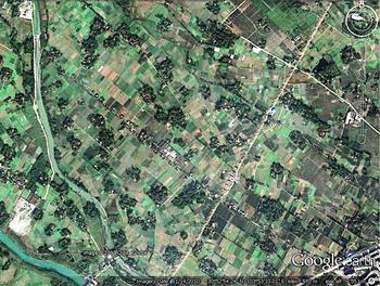
The linpan landscape lacks the nucleated villages that characterize most other flat, intensively cultivated agricultural regions of China, and instead features farmhouses scattered among the fields singly or in small clusters, usually fewer than ten (Fang Reference Zhirong2013, 66). The linpan proper, the area immediately around a farmstead, contains a great diversity of very small patches of vegetation and other land cover (see figure 2). Typically, there is the house itself with its central courtyard, flat enough to dry grain but sloped slightly so as to drain in heavy storms. There are shade trees protecting the inhabitants from the damp, debilitating heat of summer; bamboo, which also provides shade and can be made into a variety of furniture, tools, and implements; vegetable gardens; a few fruit trees; and often a part of an irrigation ditch that, historically, made it easier to get water than drawing from a well. The linpan also functions as flood control; as fallen leaves from trees and bamboo accumulate around their roots, they build up a miniature dike around the house and yard.
Aerial view of a densely settled linpan landscape on the Chengdu Plain (Google Earth 2010).

Linpan are thus a household-level spatial expression of many of the Chengdu Plain's resilient functions. Aggregated over the vast plain and beyond into the entire Sichuan Basin, this fine spatial grain of variation in field types and in forest-covered and built land makes the entire region remarkably “patchy” and biodiverse. These features produce a greater mix of cropland with natural vegetation—and single-, double-, and triple-cropped fields—than in any of China's other large, agriculturally productive regions, including the Pearl and Yangzi River deltas, the North China Plain, and the Manchurian Plain (Le Li et al. Reference Li, Friedl, Xin, Gray, Pan and Frolking2014).
Governance and Resilience
Over the course of many centuries and multiple regimes, the Chengdu Plain has been governed by a shifting combination of state and nonstate organizations. Central states, ruling from Beijing or elsewhere, have displayed varying abilities to penetrate local society, regulate behavior, and extract resources (Migdal Reference Migdal1988). Local state agencies have exercised different degrees of autonomy from these central powers, along with concomitant abilities to set policy for local communities. The governance institutions of the Dujiangyan-irrigated area form a nested hierarchy, including agencies that oversee water rights allocation and channel maintenance, facilitate information flow between decision-making levels, and ensure that decisions at each level are appropriate in context (Willmott Reference Willmott1989; Yuan Reference Lin2016). At the local level, state agencies have competed for, cooperated with, and overlapped with the authority and power of nonstate organizations, including lineages, temple associations, benevolent societies, irrigation associations, migrant homeland associations, and fraternal societies. Such overlapping structures render a social-ecological system more resilient and adaptable (Dietz, Ostrom, and Stern Reference Dietz, Ostrom and Stern2003; Ostrom Reference Ostrom1999; Walker and Salt Reference Walker and Salt2006).
The state specifies a bundle of property rights that is divisible among multiple actors, including—in rural China—the household, village (brigade), and state.Footnote 4 During the Ming and Qing, “[p]rivate property rights [over land and other tangible assets] were genuine and substantive” (Brandt, Ma, and Rawski Reference Brandt, Ma and Rawski2014, 75). In the high socialist period, by contrast, households exercised few elements in the bundle of rights; in the contemporary period, households exercise a few more of these rights. The distribution of property rights among different organizations may, like the distribution of power and authority generally, have direct effects on the resilience of the social-ecological system (Dietz et al. Reference Dietz, Ostrom and Stern2003). According to Barnes (Reference Barnes2013, 3), in assessing the capacity of property rights to promote social-ecological resilience, “we can analyze the extent to which the rules governing property are flexible, responsive, maintain future options, and allow for regulation at appropriate scales.”
Markets and Resilience
Market systems support resilience in the face of natural events such as droughts and floods. In normal times, local markets provide opportunities for farm households to exchange what they do not need for what they do not produce and to sell surpluses to build up cash reserves against emergencies or important life-cycle events. In times of stress, price increases can provide both information that food shortages are happening and incentives for merchants to move food into affected areas (Drèze and Sen Reference Drèze and Sen1991). For the market to work in these ways, it is often necessary for state actors to intervene by regulation or by entering the market themselves to prevent adverse effects of speculation.
Resilience in the Late Qing and Republican Periods
During the late Qing and Republican periods, the Chengdu Plain agroecosystem exhibited remarkable resilience, as indicated by our measures of its ability to absorb population growth and produce enough grain to feed the growing population. After the headworks were restored in the Kangxi period (Ye and Luo [1933] Reference Daqiang and Junsheng1992), the system absorbed repopulation in the early eighteenth century and the unprecedented, higher population growth that occurred through the remainder of the Qing. At a time when similar rates of population growth rendered ecosystems in many parts of China vulnerable to disasters, to the point that China became known in English as “The Land of Famine” (Ho Reference Pingti1959; Lillian Li Reference Li2007; Pietz Reference Pietz2015; White and Jacoby Reference White and Jacoby1946), Richthofen and other contemporary observers highlighted the prosperity and abundance of the Dujiangyan Irrigation District. For example, in 1896–97 (Bishop Reference Bishop and Bird1899, 506), 1900–01 (Davies Reference Davies1901, 170), and 1936–37 (Zheng Reference Guanglu2001), famines occasioned by drought devastated much of Sichuan but spared the Dujiangyan irrigation area.
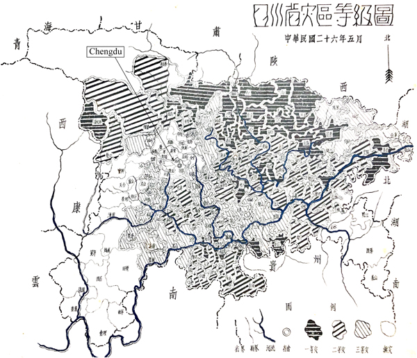
In 1937, the Sichuan Provincial Relief Commission produced a map of specific areas of Sichuan suffering from disasters, at a time when Sichuan was widely reported to have experienced province-wide famine. The absence of disaster in the Chengdu Plain (compared to other densely settled areas of Sichuan) is striking; it is the only part of the province that is labeled on the map as “no disaster,” while the remainder of the province is labeled as “mild, moderate, or severe” disaster areas (see figure 3). Ecological, governance, and market factors all contributed to this remarkable resilience in the face of drought.
Map of Sichuan disaster areas (Sichuan Sheng Reference Sheng1937). Unshaded areas experienced no disaster.

Ecological Factors
In addition to reliable irrigation and flood control from the Dujiangyan, the linpan landscape contributed to the Chengdu Plain's resilience to large-scale disturbances across history. Skinner, observing in 1949, reports that within a few-kilometer radius of Gaodianzi, a market town to the east of the city of Chengdu, the land was divided into tian, or wet rice fields (which also grew wheat or rapeseed in the winter, another kind of diversity), and di, or unirrigated, usually slightly hilly land, on which a range of crops were grown. Even a single farmer—the Mr. Lin Baoqing with whom Skinner stayed for two and a half months in the fall of 1949—though he had no tian, cultivated diverse crops on his 14.6 mu of di: sweet potatoes, taro, millet, and corn; vegetables including peas, hot peppers, and others; fruits including tangerines, oranges, and pomelos; and cotton (Skinner Reference Skinner, Harrell and Lavely2017, 66). If diversity contributes to resilience, the small farmers of the Chengdu Plain in 1949 managed a resilient landscape.
Governance Factors
The governance structures responsible for the resilience of the system are well illustrated in Skinner's account of cross-cutting institutions. In the same area of the Chengdu Plain in the 1940s, there were both official and unofficial governance organizations, whose membership and functions overlapped. Officially, there was the top-down governance of the Republican regime, extending from county (xian) to township (xiang) to bao, a unit of over one hundred households, to jia, of which ten or eleven comprised a bao (Skinner Reference Skinner, Harrell and Lavely2017, 36). However, other organizations were just as important and powerful, if not more so, than the official hierarchy. The pao ge, or “Brothers of the Robe,” otherwise known as the ge lao hui, was a fraternal society presided over by landlords or well-off peasants, but open to all “of good character,” and it effectively controlled who was selected to the official government positions (Skinner Reference Skinner, Harrell and Lavely2017, 56; Wang Di Reference Di2010). Lineages, temple committees, and the Confucian shan tang or Hall of Virtue all controlled resources, including land, and had influence in local decisions, from tax collection and charity dispensation to the timing of festivals and resolution of disputes between families. It was impossible in this situation to get anything done without agreement from both the official and the unofficial organizations (Skinner Reference Skinner, Harrell and Lavely2017).
At the same time, the property rights system was flexible and responsive, allowing private landowners to assign the bundle of rights in multiple ways. Some large farmers both rented in and rented out land (Li Deying Reference Deying2007; Skinner Reference Skinner, Harrell and Lavely2017, 66). The result was a governance structure that did not place too much power in the hands of any one organization or channel power into any one hierarchy. Coupled with the linpan landscape, these diverse, cross-cutting, and flexible structures of governance promoted resilience during the late Qing and Republican periods.
Governance and ecology came together in the yearly repair (suixiu) system, in which crews dredged out accumulated sediment in the Inner River and its branches and did any necessary repair on the banks of the irrigation canals. Although this system had existed at least since the Song, it reached maturity during the Qing. During this period, the principles behind the engineering of the system downstream from the headworks became encapsulated in the slogan “shen tao tan, di zuo yan,” or “dredge the banks deep and build the dikes low,” a principle retroactively attributed to Li Bing, the original designer of the Dujiangyan. The yearly repair required large numbers of laborers, grain to feed them, and money to pay for the grain; the labor force was coordinated by the General Office of Waterworks in Chengdu. Originally, each county contributed a number of laborers according to its amount of irrigated rice land; very early on, the contribution was converted to a money payment that would go to hire and feed workers (Wang Gang Reference Gang1991, 525). As the Reverend Torrance (Reference Torrance1924, 77) described it:
Forty thousand bamboos are said to be used annually in the repairs, and the sum spent over $10,000. The money is trifling compared to the wide area supplied with water. Eleven [Xian] or districts profit by the system. It makes possible in them a population of 1,200 to the square mile.… [C]ould the same long-continued benefits be said of any other irrigation works the world over? Probably not.
Evidently, the burden on the population from the requirements of yearly repair was not enough to threaten the sustainability of the system.
Market Factors
The Qing state, at least in its early years, combined market regulation with direct distribution and loan of food and seed grain; these actions prevented major droughts from becoming famines (Lillian Li Reference Li2007, 221–49). After the early Qing reoccupation, the population of the Chengdu Plain continued to grow throughout the period, accompanied by rapid growth in the periodic market system. Skinner (Reference Skinner1965, 209) describes a three-stage process of market intensification: first simple expansion of volume, then adding new market days, and finally adding new markets. Local markets operated every three days, and an enormous variety of foodstuffs and other goods were available both at open market stalls and at shops and stores. On market days, areas of the market were devoted, for example, to eggs, large and small quantities of rice, livestock, chickens and ducks, vegetables and fruits, bamboo poles, wood and other fuels, grass sandals, and fish (Skinner Reference Skinner, Harrell and Lavely2017). Thus, no one needed to try to be self-sufficient. Analyses by Gao (Reference Wangling, Sizhi and Wenhai1984), Xie (Reference Fang2010), and Skinner (Reference Skinner1965) indicate that the peasant economy of the Chengdu Plain became more commercialized throughout the Qing, that households came to depend more on exchange for their livelihood, and that markets enhanced the resilience of the agricultural system.
The Limits of Resilience During High Socialism
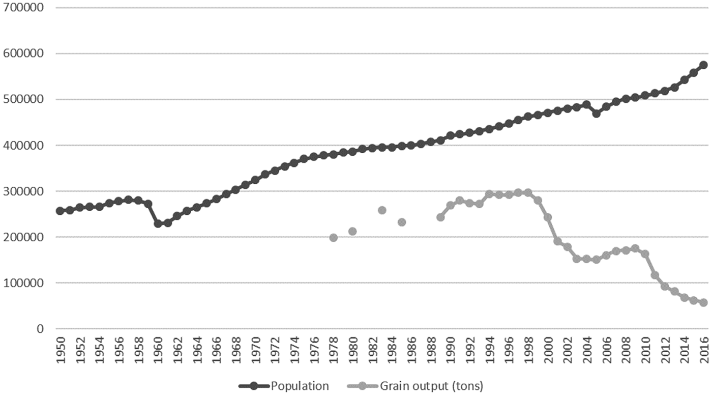
In the context of the longue durée of development, the mid-twentieth-century disturbances of civil war, revolution, and particularly radical collectivism severely tested the Chengdu Plain's resilience. On a shorter time scale, we know that, measured by our two proxies, the system's resilience failed during the Great Leap Forward of 1958–61: the plain could no longer feed its large population, despite an increase in grain production and the uninterrupted functioning of the irrigation system. This is the only famine we know to have struck the counties of the Dujiangyan Irrigation District since the establishment of the system over two millennia before. Figure 4 shows the official population of Pi County from 1950 to 2016, including a notable decrease of more than 43,000 from 1959 to 1960. The causes of famine in the Great Leap Forward are a subject of continuing debate, but Bramall's Reference Bramall2011 study reveals an important spatial pattern: despite climatic and policy factors that operated across the entire Sichuan basin, there was great variability in mortality from county to county, even within the Dujiangyan Irrigation District.Footnote 5 The crude death rate in Pi County “soared from 12 per thousand in 1956 to 175 per thousand in 1960 (one of the highest rates in all China), whereas in nearby Shuangliu, which started with the same mortality rate in 1956, it never exceeded 37 per thousand” (Bramall Reference Bramall2011, 999).
Population and grain output in Pi County, 1950–2016 (Pi Xian Tongji Gongbao, Pi Xian Zhi, and Sichuan Sheng Tongji Nianjian, various years).

In terms of resilience, revolutionary changes to the structure of governance and loss of market-based feedback mechanisms during the collectivization of the 1950s made the system particularly vulnerable to the disturbances of the Great Leap Forward period, from both the large scale of geopolitics and the small scale of individual leaders. As Bramall (Reference Bramall1993, 98) puts it, “the underlying truth of Maoist economic development in Sichuan is not that economic policy failed to increase living standards but rather that it was subordinated to other ends.” In the face of such disturbances, the inherited ecological buffers of the Dujiangyan irrigation system and linpan landscape were inadequate to prevent disaster in 1958–61. Indeed, during the 1950s some aspects of the ecological environment itself changed too, but for the most part the landscape remained intact and the irrigation system was even extended.
Governance Factors
Beginning in 1950, the Chinese Communist Party destroyed the pao ge, temple associations, and other unofficial fraternal, religious, and educational organizations; took land and power away from lineages; and thus eliminated most of the cross-cutting governance structures from before the 1950s. Land reform in the early 1950s targeted large and absentee landholders, abolished the flexible system of leasing and subleasing, and redistributed arable land acreage—adjusted for quality—to households on an equal per-laborer basis. Formerly landless tenants gained control of temple and lineage holdings, replacing “feudal” power structures that had traditionally held land in reserve as a buffer against population growth, flooding, or drought (Endicott Reference Endicott1988; Wang Ruifang Reference Ruifang2010, 129–63).
At the local level, property rights in land, including decision-making rights, were vested at scales too great for flexible and responsive regulation of land use. The old structure was replaced with a single, top-down hierarchy from the center down to the commune (township), brigade (administrative village), and production team (small group). This structure might have worked reasonably well when policies were not too radical (or when disturbances were not too large), and it facilitated construction of large-scale infrastructure projects. However, during the Great Leap Forward it enabled local officials, acting under pressure from higher levels, to extract too much grain from teams and households. Bramall (Reference Bramall2011) notes that Sichuan Province Party Secretary Li Jingquan adopted a radical interpretation of central policies emphasizing the procurement of grain. Moreover, the Pi County administration was more zealous than most. Bramall concludes that neither macroeconomics, macropolicies, nor the macroecology of the plain are to blame; rather, local-level cadre behavior played the crucial role, exacerbating or mitigating the broader patterns of over-reporting of grain yields, overzealous state grain procurements, and allocations of labor to unproductive work. Under high socialism, political decisions faced no resistance from any competing or overlapping governance organizations; there was no diversity of governance structures that could provide resilience against such large-scale disturbances. As a result, it managed to starve the population of one of the most fertile and productive agricultural areas in the world (Bramall Reference Bramall2011).
Market Factors
The revolutionary changes of the 1950s also severely altered both periodic marketing in agricultural and consumer goods, through which people serviced their daily needs, and the land markets through which they had previously been able to buy, sell, and lease land to adjust to population changes and changes in fortunes. Beginning in 1953, the policy of unified purchase and marketing (tong gou tong xiao) replaced free markets in grain with nationalized markets, though some rural markets came under more local cooperative management (Zhang Xu Reference Xu2016). From 1958 through the following two decades, the establishment of people's communes and the organization of labor into production brigades and teams moved the scale of economic decision making from the household to the production team or higher. National policies from this time also increasingly favored industry over agriculture, and grain over other agricultural products, reducing both biodiversity and commodity diversity. In Sichuan, communes and communal dining halls were created with particular speed and kept operating longer than elsewhere, as did the practice of brigade-level accounting, “despite the prevalence of team-level accounting in other provinces and Mao's own opposition” (Bramall Reference Bramall2011, 1003). The market-oriented agroecosystem was thus already severely curtailed by the time of the Great Leap Forward, eliminating exchange as a buffer against scarcities or gluts, thus decreasing the resilience of the system in the face of policy disturbances.
Ecosystem Changes
Mao-era construction of the People's Canal, the East Wind Canal, and other hydraulic projects increased the area irrigated by Dujiangyan about three-fold, from 2.82 million mu (188,000 hectares) of cultivated land in 1949 to 8.83 million mu (588,667 hectares) in 1980.Footnote 6 In the 1970s, the system was extended beyond the Chengdu Plain itself, through the Longquan Hills on its southeast edge to Meishan along the main channel of the Min River in the south. Following this expansion, grain production more than doubled, from about 500 jin (250 kilograms) per mu in 1949 to about 1,200 jin per mu (Wu Minliang [1983] Reference Minliang2010, 63), presumably by replacing lower-yield dry field crops with higher-yielding irrigated rice. Concurrent with this expansion, the annual average volume of water passing through the system decreased by 17.9 percent from the 1930s to the 1970s—a loss attributed to climate change, deforestation, and other environmental degradation in the upper reaches of the Min River (Wu Minliang [1983] Reference Minliang2010, 64). In order to maintain adequate and consistent water volume to serve the increased demand, three new mechanical water gates were added to the system starting in the mid-1970s. By the early 1980s, agriculture received about 73 percent of the total water used in the system, industry about 10 percent, and other uses 17 percent (Wu Minliang [1983] Reference Minliang2010, 65). The overall agroecological changes throughout the Dujiangyan Irrigation District during the Mao era were a prelude to greater productivity in the 1980s and later, including rapid industrialization and urbanization. The expansion of the irrigated area continued after 1980, albeit at a slower rate.
We have only fragmentary evidence of the extent to which the linpan settlement pattern was altered during the Great Leap Forward. At its height, individual families in many communes were obliged to abandon their scattered house plots to cook and eat in communal dining halls, and sometimes to sleep in communal barracks. In Red Glow Commune in Pi County, for example, cadres demolished 180 houses that had originally been scattered among the fields in the traditional linpan pattern, forcing farmers to move to communal housing. As many as 12,000 houses in linpan throughout the county might have been similarly demolished (Yang Reference Jisheng2008, 88).Footnote 7 On the whole, however, the magnitude of change in the landscape itself, the linpan ecology, seems to have been more moderate than the changes in governance and markets, again not seriously affecting the long-term resilience of the system, despite increased maintenance costs.
This account of the Great Leap Forward in Pi County demonstrates how resilience of social-ecological systems depends jointly on ecological, market, and governance structures. In terms of the ball-in-basin metaphor, the loss of diversity and flexibility in each of these areas made the basin shallower, knocking the ball out of the basin in the short term. It further illustrates the principle that when people manage an ecosystem to maximize a single variable (grain production, for example, or grain deliveries to the state), the resilience of the system suffers, particularly when the system is at a high level of productivity. In the face of such disruptions, the inherited ecological buffers of the Dujiangyan irrigation system and linpan landscape were inadequate to prevent disaster in 1958–61. At the same time, the deeper continuity in this ecological landscape contributed to the “bouncing back” of local economies and the overall improvement in living standards in the Chengdu Plain by the end of the Mao era.
Threats to Resilience in the Contemporary Era
The contemporary era marks a return to a more regionally adapted governance approach (Rithmire Reference Rithmire2015) and to policies that rely to a greater extent on market mechanisms; however, new developments may degrade the region's ecological buffers. “China's cities, with abundant labor, cheap land, good infrastructure, and competition among local governments to attract industry and investment, have created an environment that has been highly conducive to growth” (World Bank 2014, xiii). At the same time, urbanization has over-relied on both sales of rural land into the urban market and land-backed debt (Hsing Reference Hsing2010; Tsui Reference Tsui2011). These practices have displaced farmers, undermined food security, driven urban sprawl, and threatened the environment, and they raise questions about the resilience of the Chengdu Plain in the contemporary period. In terms of the ball-in-basin metaphor, this new land-backed growth model may make the basin shallower, leaving the region less resilient.
Three characteristics make contemporary Chengdu and its surrounding plain an important case in exploring the resilience of China's agroecosystems in the current era of rapid change. First, in June 2007, Chengdu Municipality was named a national experimental zone in urban-rural integration. Second, the 2008 Wenchuan earthquake, centered just up the Min River from Dujiangyan, affected the Dujiangyan Irrigation District albeit without damaging the weir system itself.Footnote 8 In responding to the earthquake, Chengdu gained additional policy flexibility as well as an influx of reconstruction investment that was coupled with urban-rural integration (Abramson and Qi Reference Abramson and Qi2011). Third, the Chengdu Plain has an exceptionally fine-grained administrative territorialization. Proponents of metropolitan agglomeration economies see such territorial “fragmentation” as a governance challenge;Footnote 9 on the other hand, the multiplicity of territorial jurisdictions contributes to diversity in decision making over land use, potentially supporting a region's resilience. To demonstrate the changes of the reform period, we continue the focus on Pi County, which was the closest rural jurisdiction to the city center of Chengdu until it became an urban district (Pidu District) in 2016. Pidu sits at the heart of the oldest part of the Dujiangyan irrigated area and contains an especially high proportion of land designated as high-grade arable, thus providing a useful illustration of the tensions involved in the urban-rural integration process.
Governance
Twenty-first-century Chengdu Municipality serves as a national pilot for a new approach to urban-rural integration, with the goal of optimizing land use across the urban-rural divide. In 2003, Chengdu implemented the “three concentrations” policy. This policy involved consolidating rural land, resettling farmers in rural towns, and locating factories in industrial zones (World Bank 2014, 229). In 2005, the Chengdu Land Bureau issued an opinion allowing local officials to “generate” new construction land, without reducing total arable land area, by concentrating rural housing and making former residential land available for other uses (Wang Ximing Reference Ximing2011). This presaged the national initiative, beginning during the Eleventh Five-Year Plan (2006–11), to maintain 1.8 billion mu (120 million hectares) of arable land as a “red- line” minimum. In order to control the loss of arable land, higher-level governments set restrictive quotas for the conversion of arable land to nonagricultural uses that are binding on lower-level authorities.
In 2008, the symbolically important Document #1 of the Chengdu Municipal Party Committee ushered in the practice of land quota trading, delinking the location of new construction from the location where the land quota was generated. In this case, “quota” refers to the area of land approved for construction. Local governments could generate land quotas by concentrating rural housing into denser settlements and reclaiming the vacated land for agricultural use. Many land quotas were generated by converting residential to agricultural land in a more remote rural location that could be traded for the same area of land taken out of agriculture in a higher-value peri-urban location elsewhere in Chengdu (Xiao Yuan Reference Yuan2014). The entity that invested in the arable land reclamation project—for example, a village asset management company—received, upon inspection and approval, a construction land quota certificate that could be traded for monetary payment at the Chengdu Rural Equity Exchange Center (Chengdu Nongcun Chanquan Jiaoyisuo 成都农村产权交易所) (Chengdu Shi 2010).
Following the 2008 Wenchuan earthquake, Chengdu gained even greater policy flexibility, particularly in the use of land-backed debt to finance housing and infrastructure for new concentrated settlements (Wang Ximing Reference Ximing2011). Debt financing received further impetus from the economic stimulus package that followed the onset of the global financial crisis later that year. Echoing the report of the Chengdu Committee for Balanced Urban-Rural Development, Pi County proposed using rural collective construction land use rights (including new land quotas) as collateral for loans from banks, insurance companies, and other financial entities (Qin, Reference Daihongn.d.). In turn, the Chengdu Rural Equity Exchange Center provided a platform for selling new land quotas, which, in theory, would allow borrowers to repay the debt.
Municipal planners regarded land titling as a necessary precondition for housing concentration, farmland consolidation, and land quota trading (Ye and LeGates Reference Yumin and LeGates2013, 257), and Chengdu implemented a land titling pilot before it was rolled out nationwide. Between 2008 and 2010, each household received a rural land contract management certificate, collective land use certificate (which includes specification of residential plots), forest land certificate, arable land protection contract, and housing ownership certificate.Footnote 10 Ironically, titling provided a basis for dispossessing some rural residents of their land.
The next step in the local policy of generating land quotas entailed freeing up rural construction land by concentrating housing in new, denser village developments; demolishing old linpan homesteads; and returning old homestead land to exclusively agricultural use. In this way, a new quota of construction land could be created while observing the “red line” for maintaining a minimum amount of arable land set by the Ministry of Land Resources. The new quota for construction land could then be traded for use anywhere in Chengdu Municipality.
The scattered, linpan landscape was a particularly attractive target for concentration, since homesteads covered a large area, and a significant amount of land could be freed for quota trading. In the dispersed settlement pattern, residential land typically occupied about 200 square meters per person on average, as compared to a smaller area after consolidation. Exchanges of property rights in the process of concentrating residential land were not entirely voluntary. The State Council raised concerns over the use of coercion in a 2010 notification, echoed by outside observers, including the World Bank (2014, 190). Village small groups were mobilized to concentrate en masse, reducing the flexibility and responsiveness of the existing property rights regime. In Anlong Village (Ande Town, Pi County, the same spot that Fan Chengda described in the twelfth century, quoted above), village leaders mobilized villagers to vacate their linpan homesteads and to commit to concentrated housing by promising zero net cost and even subsidies from the municipal government for finish work in the new housing settlement. Villagers described having to turn over their land documents immediately upon signing their commitment to relocate. The development of new concentrated housing was costly for households and local authorities alike. The promised subsidies were not always funded by higher levels, putting a financial squeeze on village leaders. Even when subsidies did not materialize, villagers were held to their commitments to vacate their residential land, causing some households to go into debt and others to be locked out of new housing because of their inability to pay.Footnote 11
In Pi County, even village committees became active players in generating land quotas. This process entails high initial costs, including up-front expenditures for old housing demolition, new housing construction, infrastructure development, and—in principle—compensation to farm households for vacated residential land. According to a village leader interviewed in Anlong Village:
The village asset management company is supposed to handle the expenditures for new housing, oversee returning the old residential land (zhaijidi) to cultivation, and manage the reallocation/readjustment of land rights. The village company contracts with a land reclamation unit, which must return land to cultivation according to the standard of the provincial land bureau. Then, the village company applies to the provincial land bureau for certification, documenting return of the land to cultivation.
At the time of the interview, the village leader was awaiting the arrival of the inspection team to certify the return to cultivation of one section of former residential land in the village. As of mid-year in 2015, the village had received only about 60 percent of the payment anticipated from the Chengdu Rural Equity Exchange Center for certified, reclaimed, arable land.
The policy of generating land quotas and using them as collateral for loans has contributed to local indebtedness. Local authorities, especially villages, have a limited ability to generate fiscal revenue to invest in infrastructure or housing and therefore rely on land-backed debt financing in the context of urban-rural integration. The village leader described the pressure from unpaid village debts as the greatest difficulty he faced. He worried that the village would not be able to sell the new land quotas on the exchange or not generate enough revenue from the quota sale to compensate villagers for their reclaimed residential land and to pay other debts incurred to demolish old housing and build the new village settlements. This case is one grassroots manifestation of reliance on debt financing across all levels of local government, estimated by the National Audit Office to have reached 24 trillion RMB (US$3.8 trillion) by 2014. Local governments “promise their creditors” to use land sales to repay nearly half of all debt (Wu Xun Reference Xun2016, 7). High levels of debt on the part of local governments and even villages constrain their ability to respond to unanticipated shocks.
As noted above, the coexistence of state and nonstate organizations may contribute to resilience by introducing diverse values and agendas into local policy making. In contrast to the high socialist period, today nongovernmental organizations play an emerging role in governance in Chengdu. The Chengdu Urban Rivers Association (CURA), for example, introduced a pilot project on ecological farming practices in one corner of Anlong Village. CURA founder Tian Jun indicated that “CURA's efforts led local residents to protect linpa n” (Tippins Reference Tippins2013, 61). In the context of the three concentrations policy, CURA provided part of the impetus for several families to successfully resist vacating their linpan homesteads, where they had invested in income-generating activities including organic farming and local agritourism. This exception to the concentration policy in Anlong Village highlights the role of flexible, responsive property rights regimes in promoting resilience.
Ecology
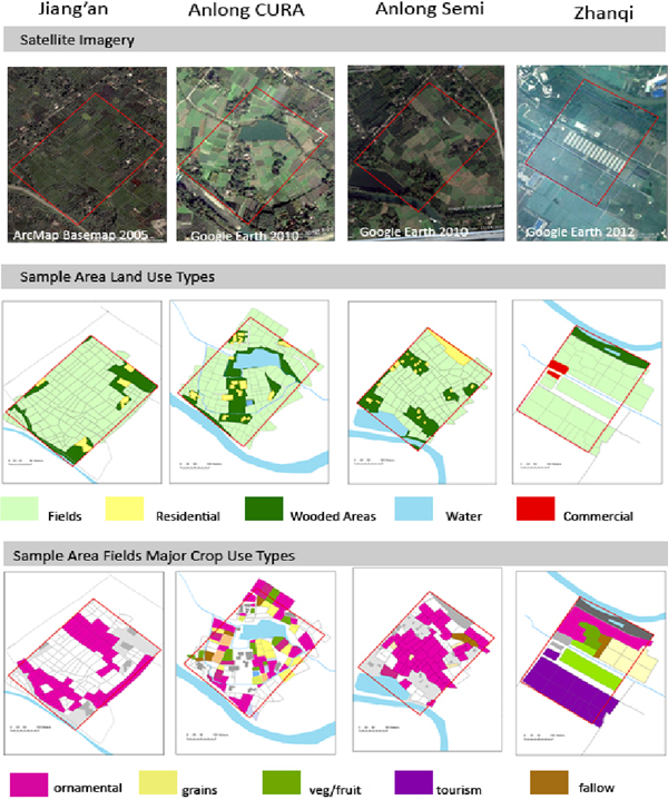
Within Pi County, four distinct approaches to concentrating rural housing settlements demonstrate the relationship between governance and ecological factors, on the one hand, and resilience on the other (see figure 5). In Jiang'an Village, no concentration of housing, new infrastructural investment, or government reorganization of land rights had taken place by 2016. In Zhanqi Village, by contrast, all households were moved to concentrated housing in one large estate that began construction in 2008, and villagers became shareholders in a village enterprise that consolidated land for agritourism, industrial food processing, and large-scale monocropping. Most of Anlong Village took an intermediate approach. Leaders concentrated housing into multiple new clusters that are less dense than those built in Zhanqi but more concentrated than the largest preexisting linpan clusters; at the same time, they reclaimed former residential land for agriculture and land quota trading. However, the neighborhood of Anlong that hosted the CURA pilot retained the preexisting linpan landscape.
Distinct approaches to concentration in Pi County (Tippins Reference Tippins2013).

Even the intermediate approach to concentration pursued in most of Anlong resulted in the loss of linpan and associated biodiversity. Employing landscape ecology methods, Tippins (Reference Tippins2013, 137–38) provides comparisons of land use across these four models with sampling frames on multiple scales. She shows that Zhanqi's extreme model resulted in loss of species and patch diversity, two factors that contribute to resilience, while these factors were partially retained in both Jiang'an and the CURA neighborhood in Anlong. Tippins's findings raise questions about official claims of protecting linpan. Official media coverage by the New China News Agency (2015) portrays the Anlong model of concentrated housing as putting “linpan at the center of the design” and “fully protecting linpan.” The village has been named as a model of “sustainable, ecological development” by Chengdu Municipality. However, Tippins's field studies show that, even in Anlong's semi-concentrated approach, the landscape reflects loss of linpan, concentration of housing, loss of forested patches, and increased monocropping as a result of the “three concentrations.”
Other threats to ecological resilience in the Chengdu Plain are emerging from changing cropping and labor practices. The trend towards fruit orchards and nurseries at the expense of other crops obviates some of the historic features of the water channel system. Trees do not need water delivered in channels; pipes and drip and spray systems work as well or better. Migration of labor to nonfarm jobs elsewhere has encouraged the hardening of channel banks with concrete in order to simplify maintenance, thereby threatening habitats, reducing plant diversity, and exacerbating variability in water flows.
An increasing share of water use going to industry and urban living may also be a factor that promotes these practices. Based on a projected increase of Chengdu Municipality's population from 12.58 million in 2007 to 16.55 million in 2030, as well as other development projections, the share of industrial and urban residential water demand is expected to rise to 64 percent of the system's total supply from its share of 36 percent in 2007, when agriculture used 64 percent (X. Huang et al. Reference Huang, You, Yang and Chai2015, 359–60). According to these projections, the total water supply through the Dujiangyan system must increase from 3.42 billion cubic meters in 2014 to 5.72 billion cubic meters in 2030 to meet total demand, even as agriculture's absolute demand for water from the system is expected to decrease.
Markets
Integration of markets on a larger scale facilitates more intensive specialization and division of labor. Pi County has become a center of ornamental horticulture along with agritourism. Fields have been converted from food crops to ornamental trees and shrubs, and food production has moved to peripheral counties—including Pujiang, Dayi, and Jintang—where the land is either peripheral to the most established sections of the irrigation district or outside it entirely. Ornamental prices were driven up by the nationwide boom in real estate development, which demanded street trees and shrubs of all kinds for new landscaping. However, as the housing market softened around 2015 in all but the largest cities, so did the market for ornamental plants. As the price of ornamentals dropped during the 2010s, farmers who depended entirely on them for income came under increasing pressure to earn wages from labor outside their communities, often at great distances. The sacrifice of food crops for both ornamentals and new concentrated housing therefore leaves residents of villages such as Anlong more vulnerable to these market dynamics, illustrating decreased resilience with diminished diversity of crops and therefore of income sources. The report that Chengdu likely became a net importer of grain in 2011, for the first time since 1872, is also consistent with a high degree of specialization and points to a possible loss of resilience, as reflected in grain output relative to population (Liang Reference Hao2015, 21; Shi Ju Zhi Ku and Li Reference Zhi Ku and Chuyue2014).
The Limits of Resilience in the Contemporary Period
Figure 4 shows that the population of Pi County increased steadily in the post-Mao era, while grain output declined, particularly after 1998.Footnote 12 Figure 6 shows that the area sown to grain declined, corresponding to the decline in grain output. Central elites have made food security a policy priority, and these declines were key considerations informing the declaration of the “red-line” minimum area for arable land to curb the massive conversion of arable land to other uses.
Historical measures of resilience like these are, however, ill-suited to the contemporary period, when the region experienced technological revolutions in industry, transportation, and information nearly simultaneously. A recent scholarly study of urbanization and food security in China confirms that grain output declines with urbanization due to diversion of water, land, and labor away from agriculture. Nonetheless, the study estimates that the decline is modest. Increases in state investment in technology, mechanization, and irrigation as well as changes in trade and consumption patterns compensate for declines in grain output (J. Huang et al. Reference Huang, Yang, Deng, Wang and Rozelle2015).
Area sown to grain in Pi County, 2000–2015 (Pi Xian Tongji Gongbao, various years). (2003 data not reported.)

What do these findings mean for resilience? A valid measure of the resilience of twenty-first-century agroecosystems is an important part of the agenda for future research. Such a measure should reflect the ability of a system to withstand natural and anthropogenic disturbances and retain its basic function. Preservation of diversity is a crucial aspect of resilience, and any measure should capture resilience independent of its co-variants and at multiple scales. One new measure is biodiversity at the genetic level. Where a species’ genetic diversity is greater, that species is more likely to survive in uncertain future conditions. For example, climate change could lead to future conditions in which it is impossible, at present, to predict which strains of tea will be best able to thrive (Ahmed et al. Reference Ahmed, Peters, Chunlin, Meyer, Unachukwu, Litt, Kennelly and Stepp2013). If genetic diversity shrinks in the present, as Ahmed et al. (Reference Ahmed, Peters, Chunlin, Meyer, Unachukwu, Litt, Kennelly and Stepp2013) demonstrate, then strains with the ability to thrive under future conditions may not be available. In future work, resilience can thus be measured by the extent of species biodiversity at the genetic level.
Conclusion
A set of ecological, governance, and market factors has contributed to the resilience of the Chengdu Plain agroecosystem over the longue durée. Changes in each set of factors can threaten the resilience of the system. Returning to the ball-in-basin metaphor, these changes may come at the cost of making the basin “shallower” for the whole regional system, that is, making the system more vulnerable to disturbances, despite current policies designed to protect arable land and maintain food production. The preceding sections have demonstrated how the interplay of governance, market, and ecological factors either support or undermine diversity, flexibility, and self-organization at multiple scales—factors that are associated with resilient systems.
The Dujiangyan Irrigation System has historically ensured a stable food supply through regulating irrigation water. Yearly maintenance has been crucial and has traditionally entailed low costs, but as the concentrated housing policy forces people to move to denser settlements and food security policy drives the creation of larger-scale farms, the costs of monitoring and maintaining the agroecosystem are likely to increase (Ostrom Reference Ostrom1990). Local residents are not as present or engaged in the linpan landscape as they used to be, and households that have relocated to more concentrated settlements are now less likely to combine farm and off-farm employment (Xiao Lei Reference Lei2015). These changes decrease the diversity of income sources and make households more vulnerable to unpredictable macroeconomic changes such as the softening of demand for ornamentals mentioned above. Ecosystem services that have historically been facilitated by the dispersed settlement pattern of the linpan landscape are now being pursued through centralized, top-down environmental management, which often leads to bureaucratic rigidity (Holling and Meffe Reference Holling and Meffe1996). For example, paved roads, sewer and solid waste–disposal systems, and animal agriculture and its associated nutrient management all encourage spatially concentrated development. A symptom of changing management is the prohibition on residents in new settlements raising pigs or water buffaloes, although they were still allowed to have chickens as of 2016.
Chengdu's program of urban-rural integration, including the “three concentrations,” has contributed to the loss of diversity, and thus of resilience, in multiple ways, including settlement pattern, land use, cropping, patch, and species diversity. In future research, diversity should be measured at the scale of species genetic diversity as well. The ecology has long been characterized by a patchy landscape, including many small, divided plots with diverse cropping patterns and sections of forest cover. As reclaimed residential land is consolidated and put to uniform use, patchiness decreases. It is not clear as of this writing what will happen to the trees in the former linpan landscape as former residential land is reclaimed for larger-scale agriculture. There is likely to be less integration of housing and forest cover, creating a more uniform, open, and potentially less biodiverse landscape. Under the present structure of fiscal institutions, land sales and land quota sales have become major sources of local revenue. Local governments have incurred unprecedented levels of indebtedness using land as collateral, a situation Wong (Reference Wong, Bahl, Linn and Wetzel2013, 304) characterizes as unsustainable. The concentration and intensification of land use, viewed from a longer historical perspective on resilience, may degrade the region's ecological buffers.
Planners in Chengdu point out that the trends we associate with the three concentrations were already in process before the program was underway. As economic development proceeds, farms get bigger and more mechanized, and populations urbanize. Indeed, planners see the program of concentrating households in new villages in the Chengdu Plain as a rectification of “chaotic” and environmentally destructive changes resulting from poorly planned urban expansion; in other words, they display faith that top-down management is the solution to problems that arise naturally in the process of social-ecological system change. By contrast, we see the three concentrations as a particular form of developmentalism that poses threats to one of the most efficiently sustainable, densely populated, and intensively productive city-regional landscapes in human history.
Acknowledgments
Jointly and individually, the authors gratefully acknowledge all of the following sources of partial support: The China Studies Program, East Asia Center, Jackson School of International Studies, Office of Global Affairs, and Center for Asian Urbanism at the University of Washington; University Transportation Center sponsored by the US Department of Transportation through Grant No. 69A3551747116 (Abramson); Chiang Ching-kuo Foundation Research Grant RG030-A-12 (Whiting); and Sichuan University Grants skqy201603 and 2018xjhz (Yuan). In addition, Daniel Abramson thanks Sichuan University, where he was Visiting Professor, 2012–17, and support for UW-SCU faculty and student participants through the Sichuan University Immersion Program.