Although most scholars agree that Athapaskan-speaking peoples arrived in the U.S. Southwest from the far north, the exact timing and routes of their travels remain elusive. One recent model proposes that Athapaskan speakers lived in the subarctic until A.D. 1000–1200, when they migrated to the British Columbia plateau; then, in multiple stages, they pushed south along the eastern flank of the Rocky Mountains until they reached the American Southwest by A.D. 1450, where they filled in settlement gaps left by contracting Pueblo communities (Matson and Magne Reference Matson and Magne2007). The Athapaskan arrivals quickly adopted aspects of Pueblo lifeways but maintained distinct survival strategies and soon split into three groups: the Kiowa Apaches on the Plains (further changed with the introduction of horses in the 1500s), the more sedentary (and later pastoral) Navajos in the northern Southwest, and the more mobile Apaches to the south. In contrast to this model, some scholars hypothesize that Athapaskan peoples traveled southward through the Great Basin or, alternatively, across the High Plains (Brugge 1983:489), and some Apache and Navajo traditions hold that they are not immigrants at all but rather have been in the Southwest since time immemorial (Gill Reference Gill and Ortiz1983; McPherson Reference McPherson2014).
Many scholars concur that whichever southern route was taken, the Navajos' Athapaskan ancestors first reached the Dinétah area of New Mexico around the mid-1500s and remained there for several centuries before starting to gradually migrate westward in the mid-1700s (Ababneh et al. Reference Ababneh, Towner, Prasciunas and Porter2000; Ellis 1974a:497; Gunnerson Reference Gunnerson and Ortiz1979:162; Hester Reference Hester1963:83; Hogan Reference Hogan1989; Kluckhohn and Leighton Reference Kluckhohn and Leighton1962:33–35; Matson and Magne Reference Matson and Magne2007:146; Rocek Reference Rocek1995:18; Sesler et al. Reference Sesler, Hovezzk, Wilshusen, Wilshusen, Hovezzk and Sesler2000; Towner Reference Towner1996, Reference Towner and Nash2000:177, Reference Towner2003, Reference Towner2008; Towner and Dean Reference Towner, Dean and Towner1996:15; Wilcox Reference Wilcox, Wilcox and Masse1981). However, some archaeologists argue that the westward push was earlier and thus Navajos settled northern Arizona well before the 1800s (Brugge Reference Brugge1967, Reference Brugge and Ortiz1983:490; Correll Reference Correll1960; Gilpin Reference Gilpin and Towner1996; Hurt Reference Hurt1942; Sundberg Reference Sundberg1995:16). Navajo settlement patterns are coming into focus but much remains to be learned (Wilshusen Reference Wilshusen, Scheiber and Mitchell2010).
Dendrochronology has been a key source of evidence in reconstructing Navajo history in the Southwest because of the prevalence of wood in Navajo archaeological sites. In this paper, we argue that some previous work has relied on individual tree-ring dates taken out of context, and this has led to confused inferences about Navajo settlement patterns in northern Arizona. While there are numerous Navajo sites associated with tree-ring dates earlier than A.D. 1800 in northern Arizona, the following analysis demonstrates that the entire assemblage of tree-ring dates from a site must be taken into account and rigorously analyzed in order to reliably date the occupation of Navajo sites. Using single tree-ring dates taken out of context, or tree-ring dates that do not cluster closely in time, leads to misleading interpretations of archaeological data. Our analysis aligns with early research on formation processes, which identified the “old wood” problem (Schiffer Reference Schiffer, McGuire and Schiffer1982), and emphasized the need for a sophisticated approach to associating chronometrically useful materials with cultural events and processes (Smiley Reference Smiley1985; Smiley and Ahlstrom Reference Smiley and Ahlstrom1998a).
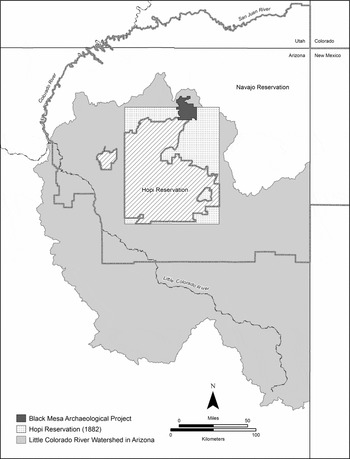
The following analysis of Navajo tree-ring data uses hundreds of dated tree-ring specimens from 774 sites within the Little Colorado River watershed, Black Mesa, and surrounding areas (Figure 1). These tree-ring data were collected during the Navajo Land Claim (NLC), Black Mesa Archaeological Project (BMAP), and miscellaneous cultural resource management (CRM) projects. The NLC field research was conducted in the 1950s and 1960s to support Navajo land claims in the Healing v. Jones litigation to determine ownership of the 1882 Hopi Reservation and the Indian Claims Commission litigation to determine the lands taken without payment by the United States (Van Valkenburgh Reference Van Valkenburgh1956). BMAP research, conducted between 1967 and 1983, involved a systematic archaeological survey to identify historic properties within the 233 km2 Peabody Coal Company lease area and excavation of a sample of sites to mitigate the adverse effects of mining (Powell et al. Reference Powell, Andrews, Nichols and Smiley1983). The miscellaneous CRM projects were predominately conducted in the eastern portion of the study area and include fieldwork conducted from the mid-1960s to mid-1980s. We compiled and analyzed tree-ring data from these projects during research sponsored by the Hopi Tribe as part of water rights adjudication in the Little Colorado River watershed in Arizona (Ferguson Reference Ferguson2009). Because of the contentious issues involved in this water rights litigation—including the issue of when the Navajo people settled on the 1882 Hopi Reservation—we sought to rigorously and objectively apply long-standing scientific principles to analyze tree-ring dates to make strong historical inferences. This is important because a key element of water rights in Arizona involves who put water to beneficial use first.
Map of the study area.

We determined that, although previous researchers have done much to illuminate Navajo history, they have too often used tree-ring data without rigor. For example, in his oral testimony during Healing v. Jones (the legal case underpinning their work), NLC archaeologist J. Lee Correll (Reference Correll1960) affirmed that a range of natural forces and human behaviors affect tree-ring dates (see also Van Valkenburgh Reference Van Valkenburgh1956:46–48), but his team treated every tree-ring date as equally valid because they did not discriminate between cutting and noncutting dates, isolated and clustered dates, or the varying archaeological contexts of the tree-ring samples. They simply used the oldest known date for every site. This approach was repeated in a subsequent major publication (Correll 1979).
Previous studies using tree-ring data from Navajo sites often interpret tree-ring dates in the aggregate rather than analyzing specific assemblages and site contexts (e.g., Begay and Roberts Reference Begay, Roberts and Towner1996:199–200; Brugge 1972; Fetterman Reference Fetterman and Towner1996; Kemrer Reference Kemrer1974; Smiley and Ahlstrom Reference Smiley and Ahlstrom1998b). These collations are methodologically untenable because they assume that all tree-ring dates are equally valid, that every kind of tree-ring date is comparable, and that all the collected specimens are associated with Navajos (see Nash 1999:16). To systematically unpack these assumptions, we established a method that begins with individual dates and then proceeds outward, connecting those dates with the structures and sites that are produced by human behavior.
Our analysis indicates that there are only 18 Navajo sites in the study area that can be reliably dated prior to A.D. 1882 (the date the Hopi Reservation was established) using tree-ring dates with a moderate-to-high level of confidence, and only one of these sites, a fortified Navajo pueblito in far eastern Arizona, dates earlier than A.D. 1800. Other lines of evidence, such as historical documents or oral tradition, may yet support alternative scenarios (Correll 1979:37; Warburton and Begay Reference Warburton and Begay2005). But we conclude that the extant tree-ring data from northern Arizona are congruent with the model of Navajo settlement patterns that entailed a gradual westward migration out of the Dinétah area of New Mexico in the mid-eighteenth century, reaching Black Mesa in Arizona about 1840, other areas north and east of the Hopi Mesas in the 1850s, and land west of Hopi in the 1870s.
Methodology
Given the right conditions, analyses of tree-ring specimens produce absolute dates that specify the year (and sometimes the season) in which a tree died. Archaeological interpretation is required to correlate tree-ring dates with human behavior, such as the construction of architectural features (Ahlstrom Reference Ahlstrom1985; Dean Reference Dean and Schiffer1978, Reference Dean, Taylor and Aiken1997; Kemrer Reference Kemrer1974:24; Nash Reference Nash1997, Reference Nash1999:10–18; Nash and Rogers Reference Nash, Rogers, Parezo and Janetski2014). A two-tiered analytical approach is needed (1) to determine the validity of a given tree-ring date as a biological fact and (2) to determine whether valid dates can be correlated with specific human behaviors and cultural materials (Nash 1999:16). Archaeological interpretation entails applying a tree-ring date to a series of other events progressively removed from the date of the specimen, e.g., the construction or repair of a building or the temporal settlement of a region (Ahlstrom et al. Reference Ahlstrom, Dean and Robinson1991:632). Archaeologists must also be acutely aware of the natural and human processes that shape the tree-ring record—for example, the use of deadwood and how weathering may unevenly destroy timbers once used for a home.
To provide a reliable analytical framework that produces strong inferences about site dating, we rely on methods established by dendrochronologists that begin with assessing individual tree-ring dates and then proceed by interpreting those dates in relation to their association with material culture. Our analysis addresses a series of six key questions.
Question 1. What Is the “Quality” of the Tree-Ring Date?
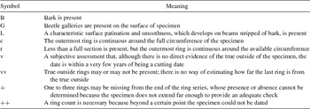
The term “quality” refers to the status of a given sample as cutting, near-cutting, or noncutting date (Bannister Reference Bannister1962:508; Nash 1999:17–18). “Cutting dates” do not specifically refer to the act of cutting wood but, also known as tree death dates, are used to indicate whether a terminal growth ring is present on a specimen (Towner Reference Towner2002:73). A near-cutting date infers that zero to three outer rings are missing, and the date thus is accurate within several years. A noncutting date means that an unknown number of outer rings are missing from the specimen. Cutting dates are the key starting point because they specify the tree event (death) most closely associated with the target behavioral event of interest (human use).
The categories and symbols used to designate the quality of tree-ring dates from the study area have changed over time (Dean Reference Dean, Dean, Meko and Swetnam1996a:464; Ellis 1974a:292–295). During the original NLC analysis, researchers used only two categories, cutting and noncutting, demarcated by a series of symbols (Towner Reference Towner2003:31). The Laboratory of Tree-Ring Research at the University of Arizona (LTRR) currently indicates cutting dates in order of decreasing confidence (Table 1). For consistency, we extrapolated the NLC system to the current LTRR system. It is not clear what NLC analysts intended when they attached no symbol at all to a tree-ring date, but we follow Ellis (1974a:287), who concluded that a lack of a symbol in NLC data indicates a noncutting date. Similarly, any NLC specimen with “inc” assigned as a symbol to signify that the last ring is incomplete is deemed a noncutting date (Towner Reference Towner2003:31). However, subsequent analyses that use “inc” for a specimen are considered a cutting or near-cutting date, if a supporting quality symbol is used, e.g., 1869LB inc (Towner Reference Towner2003:32).
Symbols Used by the Laboratory of Tree-Ring Research to Qualify Dates.

Note: Today, cutting dates are denoted using the symbols (B, G, L, c, r, v); near-cutting dates using the symbols +B, +G, +L, +c, +r, +v; and noncutting dates using the symbols vv or ++.
Cutting dates have more utility for archaeological interpretation than noncutting dates because they can specify the exact year, sometimes even the season, in which the tree died. As Nash (1999:18) notes, “In the absence of additional data, noncutting dates can provide only a terminus post quem, a date after which a given event must have occurred.” Thus, although all tree-ring dates provide a basis for establishing a minimum date for an associated archaeological feature, cutting dates are more informative because they provide a definite date for the year in which a tree died (Ellis 1974a:283; Towner Reference Towner and Nash2000:173).
Question 2. Does the Tree-Ring Date Cluster?
A single cutting or near-cutting date tells us little about the age of a structure. Because every human structure in the study area requires multiple pieces of wood, a single date may or may not be representative of the entire structure. People typically gather wood from a variety of sources—cutting down living trees, gathering deadwood, and reusing timbers from old structures—and so there is no way of knowing whether a single date is anomalous or representative (Dean Reference Dean, Dean, Meko and Swetnam1996b:497; Fetterman Reference Fetterman and Towner1996:78). When we look at one of the “most extensively sampled” and “best dated” Navajo sites—a Black Mesa site with 221 tree-ring samples—we see that every site component, including corrals, hogans, windbreaks, ramadas, and sweatlodges, includes some deadwood and reused timbers (Dean and Russell Reference Dean, Russell, Phillips and Ware2002:157–160). The Navajo used deadwood extensively (Smiley and Ahlstrom Reference Smiley and Ahlstrom1998b:68), although some types of structures are more likely to use deadwood than others. Additionally, weathering and other natural processes also impact tree-ring dates, particularly with the piñon wood often used by Navajos in the study area (Ellis 1974a:279, 283, 285). Fire, sun, and rain may destroy some timbers, while in other cases some trees may continue to remain standing even centuries after they have died (Ellis Reference Ellis1962:2–3). If only one sample is taken from a large corral, for example, it is highly unlikely that this one timber is representative of the entire corral (Russell and Dean Reference Russell and Dean1985:7).
To mitigate this problem, dendrochronologists apply the principle of clustering (Dean Reference Dean and Schiffer1978); namely, that if a collection of tree-ring dates from different specimens from the same archaeological feature cluster around a certain date, then it is likely that this cluster indicates a behavioral event. Dendrochronologists argue that “the clustering of dates from structural contexts is the most powerful tool available for the evaluation of archaeological tree-ring dates” (Russell and Dean Reference Russell and Dean1985:8). Clustering is most convincing when used with cutting and near-cutting dates; however, if a large number of noncutting dates cluster, then it is presumed that “the probability that weathering, burning, or shaping of a number of beams could remove exactly the right number of rings to cause the beams to date within a few years of one another is low” (Ahlstrom Reference Ahlstrom1985:58). Additionally, even clustered dates require interpretation—for example, when a structure has multiple clusters from widely differing periods (Towner Reference Towner2002:77). The definition of how many years constitute a date cluster, and how many dates must cluster, is not settled (cf. Ellis 1974a:284; Nash 1999:18; Rocek Reference Rocek1995:170), but, following Towner (Reference Towner2003:32), we consider a strong cluster to be constituted by “three or more cutting dates in the same year from the same architectural space” and a weak cluster, still within a three-year range, to “contain fewer dates, including noncutting dates, or be only weakly associated with architectural space.”
One reviewer of this paper argued that to demonstrate that a site has been “settled” (a stable or permanent residence) may indeed require clustering, but that even a single cutting date or near-cutting date can demonstrate land-use (for Pueblo contexts see Ahlstrom 1997). For example, suppose a hogan in Arizona had a cluster of dates to A.D. 1900, but then also had a single cutting date of A.D. 1800. The hogan would indeed date to A.D. 1900, but the single timber could also show an earlier presence of people and use of the land in that area a century earlier (after all, someone cut that timber and did not drag it from New Mexico). But without clustering it is very difficult to determine what human activity can be correlated with that single earlier date. The wood might have been cut in 1800 and then reused in 1900; it might be from a tree that died in 1800 and was cut down in 1900; it might have been cut down by a Hopi in 1800 for a ramada and then reused by a Navajo in 1900 for a hogan. There are a range of possible scenarios. Current methods simply are not able to persuasively identify which scenario actually took place from a single piece of wood. This is precisely why the principle of clustering matters in using tree-rings to date specific human actions.
Question 3. From Which Architectural Element Was the Sample Taken?
Navajo ethnoarchaeology indicates that some architectural elements are more likely to incorporate freshly cut wood than other elements. This has important implications because the more likely a sample is to be freshly cut, the more directly and confidently it can be linked with events and behaviors associated with a construction event. That is, freshly cut wood diminishes the issues raised by the use of deadwood and reused timbers in construction. In our analysis, three tiers are used to distinguish the degree of increased confidence that follows from identifying a wood element as freshly cut.
In the first tier is chinking, which refers to the wood elements in hogans and houses that are shaped to fill in gaps in the superstructure of the building. These include “tree limbs, poles, splints, brush (especially rabbitbrush, Chrysothamnus), twigs, chips, or other pieces of wood” (Jett and Spencer Reference Jett and Spencer1981:16). Significantly, chinking most often involves freshly procured wood elements, because green wood is sought after when a piece of wood is fashioned into a specific shape (such as a plug or chinking). Additionally, in the field, researchers occasionally can identify a wood element as freshly cut, presumably from the distinctive markings left by axes on green wood. A wood element identified as freshly cut increases our confidence that a cutting date directly correlates with the human behavior of interest, which is the acquisition of building materials. However, fieldworkers do not always consistently record cutting information; it also remains a subjective judgment dependent on individual experience and expertise, which can vary widely (Van Valkenburgh Reference Van Valkenburgh1956:51).
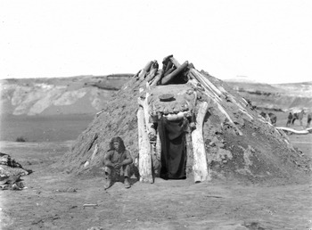
In the second tier are entries and forks (Figure 2). Hogan entries generally require freshly cut wood because the entry needs to fit exactly within the hogan's overall superstructure (Dean Reference Dean, Dean, Meko and Swetnam1996b:500–501). The vertical supporting forks in the forked-pole (also known in the literature as forked-stick) hogan are likewise often freshly cut wood; however, when a forked-pole hogan is dismantled and moved, the forks may also be moved (Dean Reference Dean, Dean, Meko and Swetnam1996b:500).
A conical forked-pole hogan, about 1900. Courtesy of the California Historical Society Collection at the University of Southern California (cat. no. 4729).

The third tier consists of any other kind of architectural element, including the side pole, main pole, base log, roof beam, pole, post, side beam, or stringer. Any of these elements may or may not be freshly cut, and may or may not be replaced, transported, or reused. Therefore, these elements do not increase our confidence in establishing construction dates.
Question 4. From What Type of Structure Was the Sample Taken?
In the same way that some individual wood elements in Navajo architecture are more or less likely to be freshly cut, entire structures are more or less likely to use freshly cut elements. Again, in the analysis, three tiers are used to distinguish the degree of increased confidence that follows from structures that are more likely to use freshly cut wood elements.
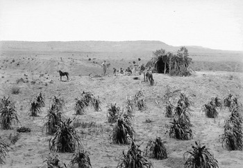
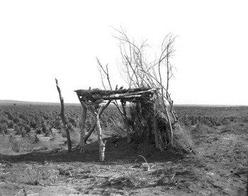
In the first tier is the summer shade, considered to be constructed from live-cut trees (Dean Reference Dean, Dean, Meko and Swetnam1996b:501; Smiley and Ahlstrom Reference Smiley and Ahlstrom1998b:68). Navajo shades are temporary shelters from the elements that typically consist of “poles and/or boughs; juniper, pinyon, cottonwood, oak, willow, and other boughs or brush, or even weeds or grasses, are used, according to local availability” (Jett and Spencer Reference Jett and Spencer1981:13). Because it is not moved and uses freshly cut timbers and branches, it is likely that dates derived from the summer shade strongly correlate with a construction event (Figure 3).
A Navajo cornfield and shade, near Holbrook, Arizona, in 1889. Courtesy of the National Archives and Records Administration (cat. no. 523554).

The second tier includes only the forked-pole hogan. Because the forked-pole hogan requires that the primary elements fit together tightly, a process made more difficult with reused timbers, this type of hogan mostly consists of freshly cut wood (Dean Reference Dean, Dean, Meko and Swetnam1996b:500). But forked-pole hogans are occasionally dismantled and moved, and an older type of tripod-plus-entry framework may be reused in place (Jett and Spencer Reference Jett and Spencer1981:62).
The third tier includes the remaining kinds of Navajo structures, including the cribbed-log hogan, corbelled hogan, many-legged hogan, livestock corral, lamb pen, sweatlodge, windbreak, and game corral. These are grouped together because none of these types of structures consistently use freshly cut timbers; some may be dismantled and moved, and, indeed, some structures depend on deadwood, stockpiled, and/or salvaged timbers (Dean Reference Dean, Dean, Meko and Swetnam1996b:500–501; Haile Reference Haile1942:55; Jett and Spencer Reference Jett and Spencer1981:15, 40, 88, 163, 192; Kemrer Reference Kemrer1974:49; Russell and Dean Reference Russell and Dean1985:6). Additionally, in general, all of these structures likely incorporate newer wood after their initial construction for repair (Rocek Reference Rocek1995:93).
Question 5. Does the Sample Come from a Culturally Diagnostic Structure?
The first four questions test the degree of confidence we have in a particular date related to construction events, while the last two questions also test whether or not dates can be securely correlated with Navajo use. The context of data is key because “although the tree-ring dates are precise and accurate, it is the archeological context and interrelationships between samples and date clusters that facilitate chronological interpretations” (Towner Reference Towner2002:77). Just as problematic as dating, for archaeologists, “an even more basic problem” is the identification of early Navajo sites “based on surface attributes alone” (Sesler et al. Reference Sesler, Hovezzk, Wilshusen, Wilshusen, Hovezzk and Sesler2000:172). Three tiers are used to distinguish the level of confidence with which we can ascribe Navajo cultural association to dated structures.
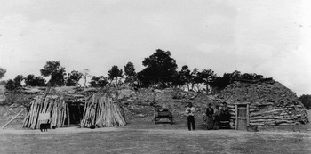
In the first tier is the hooghan, or hogan, widely considered to be the apotheosis of Navajo culture (Jett and Spencer Reference Jett and Spencer1981; Mindeleff Reference Mindeleff1898; Thompson Reference Thompson2009; Warburton Reference Warburton1985). Navajos and researchers alike recognize several different types of hogans (Jett and Spencer Reference Jett and Spencer1981:51–105). In the NLC and BMAP data sets, there are four kinds of hogans: forked pole, cribbed log, many legged, and corbelled. The conical forked-pole hogan is the type that Navajos commonly refer to in traditional songs and legends, and some consider it to be the oldest type of Navajo house (Ellis 1974a:266, 288; Haile Reference Haile1942:41; Hester Reference Hester1963:67; Jett and Spencer Reference Jett and Spencer1981:51, 53–54; Van Valkenburgh Reference Van Valkenburgh1956:5). Hence, any especially early hogan dated in the study area may likely be a forked-pole hogan. The corbelled-log hogan and cribbed-log hogan are types of stacked-log hogans (Jett and Spencer Reference Jett and Spencer1981:74). Jett and Spencer (Reference Jett and Spencer1981:78, 218) documented that the cribbed-log hogan was rarely constructed prior to 1900 (Figure 4).
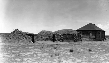
A model of the changing hogan through time, with the oldest style to the left and most recent to the right, in 1933. Courtesy of the National Archives and Records Administration (cat. no. 298586).

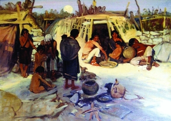
Hogans, undeniably, are deeply entwined with Navajo cultural practices, but it is erroneous to presume that all hogans or hogan-like structures identified in the archaeological record are exclusively associated with Navajo history and culture. The archaeological remains of hogans can be confused with other types of wooden structures that have morphological similarities. For instance, decayed Navajo structures can easily be confused with Havasupai habitation structures because of their physical correspondences (Colton Reference Colton1920:299; Spier Reference Spier1928:180–182). Navajo hogans may also be confused with other types of structures constructed by Hopis and other Puebloan peoples—not as they stand, per se, but when buildings deteriorate and enter the archaeological record. Historic photographs and paintings illustrate hogan-like brush structures that the Hopis constructed as temporary shelters, such as at the camp that would develop into the village of Hotvela after the Orayvi split in 1906 (Dockstader Reference Dockstader and Ortiz1979:531; Whiteley Reference Whiteley1988:123) (Figure 5), which has similarities to the leaning-log hogan (Jett and Spencer Reference Jett and Spencer1981:64–66) (Figure 6). These include one type of structure that the Hopis refer to as homoki, defined as “a large circular structure with a pointed center, esp. a circular field hut constructed from roof beams tied together at the apex or Navajo hogan” (Hill et al. Reference Hill, Sekaquaptewa, Black, Malotki and Lomatuway'ma1998:92). It is reasonable to surmise that the ancestors of the Hopis also used homoki or other wooden structures and ramadas in earlier centuries when they first migrated to the Hopi Mesas and needed temporary shelter while they awaited acceptance into a village (Bernardini Reference Bernardini2008).
Painting by Harold Betts at Hubble Trading Post illustrating a Hopi homoki constructed in 1906 at Hotvela. Photograph by Peter Whiteley. (Color online)

A Navajo leaning-log hogan is pictured to the left, in 1933. Courtesy of the National Archives and Records Administration (cat. no. 298584).

Homoki were also used in the postcontact period when sheepherding and other activities took Hopis far from their villages on the Hopi Mesas. In 1930, J. W. Hoover (Reference Hoover1930:434) described the Hopi use of “hogans,” writing:
Before the government came in, it is said that some of the [Hopi] Indians used to go as far as 45 miles to the fields every day . . . . Some one goes out to the fields every day, or some go and stay for a number of weeks but return to the villages for dances and for the winter. Temporary shelters are built for those who tend the crop. Sheep herders also go out with their flocks, remaining for some time in one locality and returning each night to a corral and hogan.
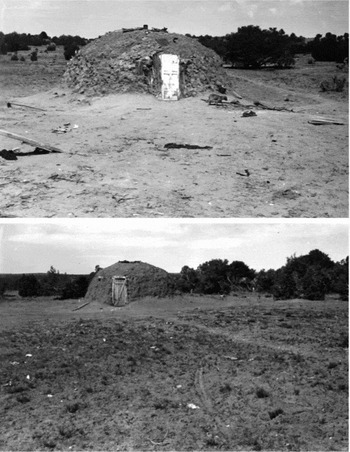
Beaglehole (1937:70) also recorded Hopi use of hogans. In this case, a Hopi man named Yusi'ima, from the Second Mesa village of Supawlavi, described a great famine in his childhood, relating how the people from his village left the mesas in search for food: “They went to Walpi, were joined there by the Walpi, then went on to Keam's [Canyon], and eastward. Near Zuñi they made camp, chopped down trees, and built hogans, one for each family.” While it is unclear whether these references mean a literal hogan or a structure that was just similar to a hogan, in the 1940s, Centerwall (Reference Centerwall1942) documented that a Hopi man named Preston Nakala owned and used two Navajo-style hogans in District 6 and District 7 on the Hopi Reservation, where he grazed cattle, sheep, and horses (Figure 7). Anthropologist Fred Eggan described “Hopi hogans” at sheep camps west of Orayvi. During the Indian Claims Commission, he testified that “I have stayed in hogan structures that Hopi have built at their sheep camps” and described these as being “generally Navajo style hogans replete with mud plastering,” adding that “they may be something they borrowed from the Navajo” (Eggan 1961:7326–7328).
Preston Nakala's “Hopi hogans” located in District 6 (bottom) and District 7 (top). Courtesy of Tom L. Perry Special Collections, Harold B. Lee Library, Brigham Young University (mss. 343, box 48, folder 9).

While the hogan is considered in this analysis to be a tier-one Navajo architectural type, it is included with the caveat that not all hogans are necessarily associated with Navajo culture and history. The “Hopi hogans” or homoki documented north of First Mesa, west of Third Mesa, and near Zuni demonstrate that some “hogans” were built and occupied by Hopis.
The second tier of culturally diagnostic structures consists of livestock corrals and sweatlodges, both of which are intimately connected with Navajo settlements when they are documented in association with hogans (Jett and Spencer Reference Jett and Spencer1981:161, 193). Many Native communities built and used livestock corrals, however, including the Hopis, who have grazed livestock for more than 400 years, so corrals by themselves are of limited diagnostic value in assigning cultural association of sites (Hoover Reference Hoover1930:434; James Reference James1997:441; Kennard Reference Kennard and Ortiz1979:557). Although some researchers have anecdotally argued that corrals can be culturally diagnostic, there is little evidence that corrals and other herding structures can be stylistically attributed to a specific tribal group (Hopkins et al. Reference Hopkins, Colwell and Ferguson2016). Sweatlodges are also of limited diagnostic value because they “are or were used by most aboriginal North American groups” (Jett and Spencer Reference Jett and Spencer1981:193).
Furthermore, the cultural association of sweatlodges, which are constructed similarly to hogans, may be misidentified because of their architectural similarity to eagle hunt houses, or kwaaamakki (Fewkes 1900a:700). Hopis constructed small stone enclosures in the vicinity of First Mesa that were used to capture live eagles, “much in the form of a Navaho hogan” (Curtis Reference Curtis1922:34), and eagle hunt houses were also made from brush and grass, as an informant told him “like a Navajo hogan, three feet high” (Beaglehole Reference Beaglehole1936:19). In the archaeological record, the physical remains of eagle hunt houses may be misidentified as Navajo sweathouses, or, if large in size, as hogans.
Hopi makki, or hunting shelters constructed using brush (Hill et al. Reference Hill, Sekaquaptewa, Black, Malotki and Lomatuway'ma1998:223), after years of weathering, could be mistaken for small hogans or sweatlodges. As described by Beaglehole (Reference Beaglehole1936:10), these brush structures were constructed during expeditions to hunt mountain sheep in areas distant from the Hopi Mesas.
The hogan, sweathouse, and corral are most convincingly associated with Navajos when all these structures appear together as part of a homestead (Landgraf Reference Landgraf1954:47–51), because “hogan, corral, family, and flocks customarily made a unit” (Ellis Reference Ellis1974a:175), and a “typical” Navajo homestead consists of a “hogan, a house or two, and a shade, placed so as to leave plenty of space between structures. In addition, one or more corrals are likely to be present, as well as, in many cases, animal shelters, root cellars, privies, beehive ovens, and sudatories” (Jett and Spencer Reference Jett and Spencer1981:9).
Consequently, like the use of hogans to determine cultural association in this analysis, isolated livestock corrals and sweatlodges are interpreted with circumspection. Only when sweatlodges and livestock corrals are recorded in association with hogans are they considered to have second-tier interpretative value.
The third tier of interpretive value comprises architectural features used by Navajos but also widely used by other Native groups in the study area. As J. Lee Correll (Reference Correll1960:178) observed, “There are a number of structures which are not diagnostic to any tribe, such as the windbreak, the stock corral, stone houses, and certain types of fortification.” Windbreaks (Jett and Spencer Reference Jett and Spencer1981:33; Mindeleff Reference Mindeleff1891:218), brush lean-tos (Ferguson and Colwell-Chanthaphonh Reference Ferguson and Colwell-Chanthaphonh2006:126; Hill et al. Reference Hill, Sekaquaptewa, Black, Malotki and Lomatuway'ma1998:579; Jett and Spencer Reference Jett and Spencer1981:38), ramadas (Jett and Spencer Reference Jett and Spencer1981:41), and still other structure types (Ellis Reference Ellis and Ortiz1979:443) were all built by Navajos, Puebloans, and others, and would be especially hard to associate with a particular tribe once they fell out of use and entered the archaeological record (Figure 8).
A shelter constructed adjacent to a Hopi cornfield in 1903. © The Field Museum, Image No. CSA11406.

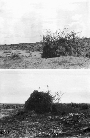
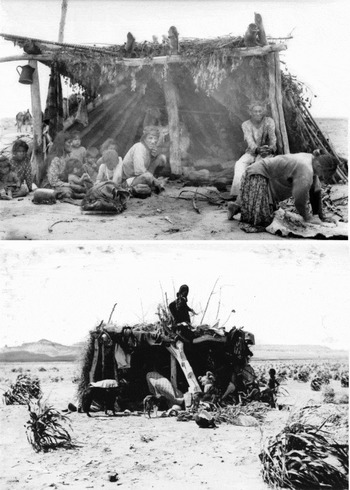
Some Navajo structures could be confused with a traditional Hopi structure used in fields and sheepherding practices, generally known as a kìisi (field hut) (Hill et al. Reference Hill, Sekaquaptewa, Black, Malotki and Lomatuway'ma1998:139) (Figure 9). Fewkes (1900b:1005) thought that this brush lodge, also built and used by Hopis during the snake and flute ceremonies at First Mesa, was a survival from ancient times, related to the cultural history of the ceremony with which it is connected (see also Curtis Reference Curtis1922:149, 153, 160; Hough Reference Hough1915:154). Some huts have distinct similarities to Navajo-made structures (Forde Reference Forde1931: Plate XLIII, Figure 4). Mindeleff (Reference Mindeleff1891:217–219) recorded several variations of this structure type, including a tuwahlki created to shelter children watching over melon fields and a kishoni, which is an uncovered shade made of cottonwood, willow, greasewood, sage, and rabbit brush. Hopis construct more substantial, covered field structures, which have distinct morphological similarities to Navajo shades and summer hogans (Figure 10).
Hopi field houses on the Hopi Reservation. Note the earthen dugout structure in the bottom image. Top: Courtesy of the Milwaukee Public Museum (cat. no. 6651); Bottom: © The Field Museum, Image No. CSA262, Photographer Charles Carpenter.

Top: A Navajo family in front of a shade at the Painted Desert, about 1901. Courtesy California Historical Society Collection at the University of Southern California (cat. no. 1009); Bottom: A Hopi family processes corn around a kìisi at Tsivokpi, along Polacca Wash near Musangnuvi, about 1900. Courtesy Milwaukee Public Museum (cat. no. 44739).

Game corrals, referred to in NLC site forms as antelope corral catch pens, are also of third-tier interpretive value. These game drives “consisted of a large, high-walled, circular corral of piled pinyon and juniper boughs or, rarely, a pitchpole- or palisade-fenced corral” (Jett and Spencer Reference Jett and Spencer1981:172). Wild game was funneled into the enclosure, where they could be killed. Some researchers seem to assume that game corrals, even those located near the Hopi Mesas, could have been constructed and used only by Navajos (e.g., Gilpin Reference Gilpin and Towner1996:193; Kemrer Reference Kemrer1974:117). Yet there is ample evidence for game drives among Hopis (Beaglehole Reference Beaglehole1936:8; Bourke Reference Bourke1962:84; Hough 1918:285; McCreery and Malotki Reference McCreery and Malotki1994:70; Parsons Reference Parsons1936:149), Zunis (Ferguson and Hart 1985:43), Yavapais (Gifford Reference Gifford1936:264–265), and myriad precolumbian and post-Columbian Pueblo communities (Beaglehole Reference Beaglehole1936:24; Fewkes 1906; Jett and Spencer Reference Jett and Spencer1981:173; Peckham Reference Peckham1965).
Given the widespread use of windbreaks, stock corrals, stone houses, and game drives by many cultural groups, none of these third-tier structures can be assumed to have Navajo association unless there is additional supporting evidence.
Question 6. What Artifacts Were Recorded at the Site?
This question seeks to establish correspondences between dated Navajo structures and associated material culture. The first tier is comprised of artifacts on the site that are considered to be exclusively Navajo in manufacture and use; the second tier is comprised of mixed Navajo and non-Navajo artifact assemblages, and the third tier is comprised of artifact assemblages with exclusively non-Navajo material culture or the complete absence of artifacts in site recordation. If only Navajo artifacts are found in context with a Navajo structure, then this increases the confidence in which we can say that a site is associated with Navajo use. Furthermore, if the recorded artifacts are temporally diagnostic, and the dates of these artifacts coincide with the tree-ring dates, this increases our confidence in both the cultural association of the structure and the tree-ring dates (see Sesler et al. Reference Sesler, Hovezzk, Wilshusen, Wilshusen, Hovezzk and Sesler2000). However, when non-Navajo artifacts are present in an assemblage, the degree of confidence in association is diminished (although it is certainly likely that Navajos may obtain and use objects that are not diagnostically Navajo). When artifacts are absent, or when the entire artifact assemblage is identified as non-Navajo, then there is only a weak archaeological association of the dated structure with Navajo culture.
Ceramics are typically one of the best artifact types for cultural and temporal identification, yet NLC researchers often recorded only indefinite ceramic types in their site reports (e.g., “Anasazi”). NLC researchers inconsistently reported ceramics in part because the first NLC research director believed that “the establishment at this time of a [Navajo] chronology based on pottery sherds is impossible” (Van Valkenburgh Reference Van Valkenburgh1956:67). This is a peculiar statement, given that many of the director's contemporaries enthusiastically used Athapaskan pottery as cultural and temporal diagnostics (e.g., Farmer Reference Farmer1942; Hall Reference Hall1944; Hurt Reference Hurt1942; Mera Reference Mera1938). Nevertheless, because ceramics on the surface of NLC sites were not systematically recorded and do not provide a representative sample, pottery has limited analytical value in the archaeological interpretation of NLC tree-ring dates.
Summary of Analytical Method
Each of the six questions discussed above can be answered independently, but they are analytically linked in a series to determine the confidence we can have in interpreting tree-ring dates associated with Navajo settlement. This analysis establishes the confidence we have that sites are both securely dated and culturally associated with Navajos, expressed in terms of high, moderate, low, and no confidence. The degree of confidence we have in the dating and cultural association of a given site depends on the answers to the six questions (Table 2). The numbers in parentheses in Table 2 represent the tiers of interpretive value as outlined in the discussion of each question.
Example of Approximate Degrees of Confidence.

Note: Values are an example from one site in the dating and cultural association with Navajos.
In this analytical framework, we consider there to be a high degree of confidence that Navajo sites date prior to 1882 when there are specimens with cutting dates (Q1), the cutting dates are strongly clustered (Q2), they are from an architectural element that is likely freshly cut (Q3), they are from a structure likely to use freshly cut timbers (Q4), they are from a structure closely associated with Navajo culture (Q5), and there is a corroborating artifact assemblage (Q6). In this framework, the first two questions are necessary conditions, so if a tree-ring date is a cutting date but does not cluster with other dates, or where there are no cutting dates, then the tree-ring data have limited interpretive value. The exception would be if a noncutting date clusters with cutting dates, or if a large number of noncutting dates cluster.
This analytical framework is not conducive to a quantitative measure of confidence. Given the data sets and the nature of archaeological interpretation of tree-ring evidence, it would be inappropriate to devise a purely quantitative scheme. Instead, the method presented here provides a reasonable and systematically grounded analytical structure for interpreting tree-ring data.
Analysis of Tree-ring Data
The tree-ring data used in our analysis are primarily derived from archival materials and published documents produced for the Navajo Land Claim (NLC) and the Black Mesa Archaeological Project (BMAP), both of which greatly advanced Navajo archaeology (Towner and Dean Reference Towner, Dean and Towner1996:8). Fieldwork for the NLC entailed a targeted survey to locate Navajo sites and to collect numerous tree-ring samples from archaeological features (Correll Reference Correll1960). NLC researchers compiled tree-ring data pertinent to the Little Colorado River watershed using sites located in the upper, middle, and lower Little Colorado River drainage, including the area incorporated into the Hopi 1882 Executive Order Reservation. During BMAP research, tree-ring samples were collected from recorded site features. Additionally, several tree-ring samples were collected and analyzed during other projects. These projects employed different approaches and methods, held different assumptions about how to collect good samples, and employed fieldworkers with varying levels of experience and expertise. As a result, we evaluate the projects separately and do not combine the data.
Navajo Land Claim Data
The NLC tree-ring data used in our analysis were gathered from two sources: the John S. Boyden Papers in the Tom Perry Special Collections, Harold B. Lee Library, Brigham Young University (BYU), and the Navajo Land Claim Dendrochronology Files, Laboratory of Tree Ring Research, University of Arizona (LTRR). Boyden was the attorney representing the Hopi Tribe in judicial proceedings, and his collection at BYU includes a full set of testimony and court exhibits from the Healing v. Jones and Indian Land Claims litigation. The first step involved using archaeological site forms and other archival documents at BYU to compile a list of all tree-ring dates in the Little Colorado River watershed dating before 1882. The second step entailed research at the LTRR to determine whether any of the NLC tree-ring specimens had been re-dated since the original analysis. From the data sets reported in the LTRR and BYU archives, a total of 467 tree-ring specimens from 208 sites in the Little Colorado River watershed dated before 1882 (Stokes and Smiley Reference Stokes and Smiley1964, Reference Stokes and Smiley1966).
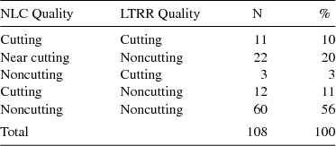
Although most of the tree-ring specimens were dated during the original NLC project, a re-dating project undertaken by LTRR researchers resulted in some original NLC dates being corrected using contemporary standards (see Dean Reference Dean, Dean, Meko and Swetnam1996a:465). Given the general improvement of tree-ring dating over time, where there was a conflict between the original NLC dating and LTRR re-dating, we used the revised LTRR data in our analysis. The LTRR has re-dated 108 out of the 467 tree-ring specimens we analyzed (23 percent). In most cases, the tree-ring dates are the same, but they differ significantly in terms of determinations of cutting-status (Table 3). In a typical example, where NLC research recorded a specimen as dating to 1798G (cutting), the subsequent reanalysis by the LTRR recorded the same specimen as dating to 1798++vv (noncutting). The cutting-status of 66 percent of the NLC dates (n = 71) in this sample of 108 specimens was confirmed with reanalysis. Only three percent of the NLC dates (n = 3) were interpretively strengthened through reanalysis, moving from the category of noncutting to cutting dates. In contrast, 31 percent of the NLC dates (n = 34) were interpretively weakened through reanalysis, moving from the category of cutting or near-cutting to noncutting dates. This indicates that NLC analysts may have (however unwittingly) overemphasized the interpretive strengths of nearly one out of every three of the original tree-ring dates. The reanalysis of tree-ring specimens demonstrates why the original NLC data need to be used with caution.
Differences in NLC and LTRR Cutting-Status Assigned to Tree-Ring Specimens.

After the list of NLC dates was compiled, the first step in our analysis was to determine which specimens are cutting and near-cutting dates. Of the 467 specimens from the 208 sites in the upper, middle, and lower Little Colorado River, 14 percent (n = 69) are cutting dates and 12 percent (n = 56) are near-cutting dates, while 74 percent (n = 351) are noncutting dates. The second step in the analysis was to determine which of the 125 cutting and near-cutting dates cluster, either weakly or strongly. The analysis yielded a total of 59 tree-ring dates from 16 archaeological sites that exhibit clustering.
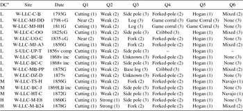
Each cluster of tree-ring dates was closely examined to determine whether any of the date clusters provide evidence for Navajo settlement prior to 1882. The 16 sites were separated into categories based on the degree of confidence associated with evidence of Navajo settlement (Table 4). We have low confidence in 11 of these sites because associated dates are inconclusive or the sites are not associated with architecture or material culture that is unambiguously associated with the Navajo. We do not consider sites demonstrating low confidence to validly date Navajo sites settled prior to 1882. We have moderate confidence in three sites, with dates ranging from the mid-1850s to the early 1870s. We have a high degree of confidence for only two of the sites, which have strong material evidence that indicates that they were associated with Navajo people. We accept sites with moderate-to-high confidence as identifying Navajo sites settled prior to 1882.
NLC Sites with Pre-1882 Tree-Ring Dates.

*DC = Degree of Confidence: Low (L), Moderate (M), High (H)
Thus, out of several hundred Navajo archaeological sites with hundreds of datable tree-ring samples in the Little Colorado River watershed in Arizona, it is striking that only five sites have a moderate-to-high degree of confidence of being Navajo sites settled prior to 1882. These NLC data, which produce ages from A.D. 1856 to 1878, indicate that a small number of Navajos first began to settle pockets of the Little Colorado River watershed in Arizona just after the mid-nineteenth century, when Navajos fled from military campaigns conducted by the U.S. Army and then continued to settle in the region following their release from internment at Fort Sumner in 1868.
Black Mesa Archaeological Project Data
Tree-ring data to investigate Navajo sites on Black Mesa before 1882 were derived from the files of the Black Mesa Archaeological Project Dendrochronology Files, Laboratory of Tree Ring Research, University of Arizona. The first analytical step was to compile pre-A.D. 1882 dates, as reported in Robinson and Towner (Reference Robinson and Towner1993). The dendrochronology files for sites with reported pre-A.D. 1882 dates were then examined to collect additional information. Although these files are in many ways comparable with the NLC files, two categories were not as consistently completed: information concerning which internal feature a given specimen was taken from, and what artifacts, if any, were present in the structure from which the specimens were removed.
The lack of these records makes it somewhat difficult to apply BMAP data to our model and to compare BMAP data to the NLC data in our model. For example, using the NLC data, we had only low confidence that the site W-LLC-MJ-A3 was a Navajo settlement because, although the date appears probable at 1856, it was recorded as having non-Navajo artifacts present. In comparison, the BMAP site AZ:D:11:422 has the same answers to questions one through five, but no data for question six (what artifacts were recorded at the site); yet we determined that one can have moderate confidence in AZ:D:11:422 as being a Navajo settlement dating to 1846 (see below). We drew these conclusions because we did not want to dismiss the BMAP data simply because they are incomplete. Hence, the degree of confidence we determine is more consistent within each data set than between them. This was an unfortunate but necessary approach because the datasets are not directly comparable and consistent.
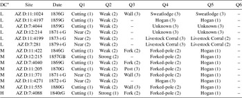
Robinson and Towner (Reference Robinson and Towner1993) report 504 Black Mesa sites yielding from one to 142 tree-ring specimens. Of these, 127 sites had at least one or more tree-ring specimens dated prior to 1882. Only 14 of these sites, associated with a total of 48 cutting and near-cutting dates, had tree-ring specimens exhibiting weak or strong date clusters. We suggest that there is a low degree of confidence for six sites, a moderate degree of confidence for seven sites, and a high degree of confidence for one site (Table 5).
BMAP Sites with Pre-1882 Dates.

*DC = Degree of Confidence: Low (L), Moderate (M), High (H)
Out of the hundreds of Navajo archaeological sites recorded on Black Mesa, only eight sites have a moderate-to-high degree of confidence of being settled by Navajos prior to 1882. The earliest date of 1840 extends Navajo settlement of the study area 16 years earlier than the date securely established by NLC tree-ring data. The next securely dated site is from 1857–1862, confirming that a Navajo family lived in the area during the so-called flight period when Navajos sought to evade capture by the U.S. Army (Indian Claims Commission 1970; Kemrer Reference Kemrer1974; Roessel Reference Roessel and Ortiz1983). The remaining sites all date to after 1869, substantiating Navajo settlements on Black Mesa after Navajos were released from Fort Sumner.
Our analysis of BMAP tree-ring data agrees with that of Rocek (Reference Rocek1995:18), who observed that “the absence of definite pre-1830 dates in the large BMAP sample supports the view of a gradual northward (or northwestward) spread of Navajo settlement into the area, with slightly earlier dates coming from the central part of the mesa” (see also Stokes and Smiley Reference Stokes and Smiley1964; Towner and Dean Reference Towner, Dean and Towner1996:10). The Navajo settlement of Black Mesa seemingly increased after 1868 (see Warburton Reference Warburton1985:125–145), although, for the remainder of the nineteenth century, most sites were seasonally occupied during the fall and winter (Rocek Reference Rocek1995:20).
Data from Other Sites in the Little Colorado River Basin of Arizona
Several other research projects have produced datable tree-ring specimens from Navajo sites in the Little Colorado River watershed of Arizona. These projects include fieldwork by the Bureau of Indian Affairs (BIA) Branch of Forestry from the late-1970s to the mid-1980s on the Navajo National Forest, cultural resource management projects for the Navajo Nation along the Piñon Road, an informal collection of a specimen by a road construction crew near Tsegi Canyon, archaeological research done for the Navajo Nation in the Dinnebito Wash valley, an excavation project in the early 1970s by the Museum of Northern Arizona for the Arizona Public Service 500 KV Transmission Line Project, and research by the Arizona State Museum in 1965.
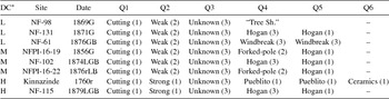
The LTRR files were used to compile data from 62 additional sites in the study area that produced tree-ring samples that dated prior to 1882. These data were analyzed using the same methods applied to the NLC and BMAP datasets. It was determined that 29 sites had cutting or near-cutting dates, while 33 of the sites produced noncutting dates. Of the 29 sites with cutting or near-cutting dates, eight strongly or weakly cluster with other dates from the same structure or site. An analysis of these sites and their associated dendrochronological data indicates that we can have a low degree of confidence for three sites, a moderate degree of confidence for three sites, and a high degree of confidence for two sites (Table 6).
Additional Navajo Sites in the Little Colorado River Watershed with Pre-1882 Dates.

*DC = Degree of Confidence: Low (L), Moderate (M), High (H)
The most notable sample in this grouping comes from the site known as Kinnazinde; it produced a cutting date of 1760r, which forms a strong cluster with other tree-ring dates from this Navajo pueblito, including 1703v, 1751v, 1755v, 1756vv, 1758v, 1759v, 1759rB, 1759c, 1759r, 1759c, 1759v, 1759r, and 1760r. The site is located in the vicinity of Leroux Wash and Pueblo Colorado Wash about 40 km west of the Arizona-New Mexico boundary. Tree-ring dates from Kinnazinde were reported by Douglas (Reference Douglas1935:52), Smiley (Reference Smiley1951), and Bannister et al. (Reference Bannister, Hannah and Robinson1966:24). During the NLC, the site was designated as S-MLC-LP-L, and the tree-ring samples NLC researchers collected from a forked-pole hogan at the Kin Náázíní or Lone Towering House site provided noncutting dates of 1721vv and 1724vv. This pueblito comprised a two-story-high masonry building defensively situated on top of a boulder or stone outcrop, with an associated stone hogan ring, three forked-pole hogans (one with elements cut using a metal axe), three rock piles, one rock alignment, and a corral (Gilpin Reference Gilpin and Towner1996:179-183). Associated artifacts include Dinétah Gray and Gobernador Polychrome ceramics, along with flaked petrified wood and chert, two choppers and a piki stone fragment. Mindeleff (Reference Mindeleff1891:91-93, Plate LXVI), Fewkes (Reference Fewkes1898:534; 1904:34), and Reagan (Reference Reagan1928:23) thought that Kinnazinde was a Puebloan site occupied during the precolumbian period, and the NLC site record notes that Eric Reed identified Kinnazinde as a “Zuni Refugee” site, but contemporary archaeologists attribute it to the Navajo.
With the exception of Kinnazinde, tree-ring dates of other sites in the Little Colorado River watershed in Arizona demonstrate Navajo settlement in the latter half of the nineteenth century, with one site dated with moderate confidence to 1856, and three sites dated with moderate or high confidence to the 1870s. Kinnazinde, a Navajo pueblito, dates to 1760. Eighteenth-century Navajo pueblitos are most common in the Dinétah area of northwestern New Mexico, where they are interpreted as defensive sites built in response to Ute raiding (Towner Reference Towner2003). Kinnazinde probably represents the initial entry of Navajos into the Little Colorado River watershed of Arizona in the mid-eighteenth century. The location of Kinnazinde in a defensive position midway between the Hopi Mesas and Zuni Pueblo suggests that the first Navajos in the Little Colorado River Basin moved into a new territory, where they were possibly concerned about attacks from the Hopis and Zunis who had long resided in the region.
Conclusion
When presented with a simple, uninterpreted list of the hundreds of tree-ring dates collected from Navajo sites in the Little Colorado River Basin, it seems as if there are many sites dating from the 1600s onward, extending over all of northern Arizona. However, as Dean (Reference Dean, Dean, Meko and Swetnam1996b:503) reminds us, “Tree-ring dating the archaeological manifestations of past human activities is far more complex than is commonly supposed.” This paper demonstrates that when tree-ring dates are critically examined using a rigorous methodology to determine which dates have a moderate-to-high degree of confidence, there are few Navajo sites in the study area securely dated before the mid-1800s.
Our historical interpretations may be contrasted with that of Gilpin (Reference Gilpin and Towner1996:171), who argued:
What few archaeological data exist indicate that by the 1760s, the Navajo west of the Chuskas were constructing pueblitos, living in large villages, practicing herding and agriculture, and creating rock art identical to that of the Dinétah. Thus, the western Navajo have a longer history in the region than is often recognized.
To support this argument, Gilpin used archaeological data from previous surveys, and asserts that some 47 Navajo sites have been recorded west of the Chuska Mountains that date to the 1700s. A map of the study area summarizes these putative sites (Gilpin Reference Gilpin and Towner1996:172, Figure 8.1). More than half of these sites are clustered around Canyon de Chelly, a few sites are located on Chinle Wash north of the canyon, and, to the south, about six sites are located in the headwaters of the Pueblo Colorado and Black Creek. Eight remaining sites are more than 32 km to the west, located around Black Mesa—all sites from the NLC database.
Gilpin argues primarily from the documentary and material evidence. That is, he is not depending on Navajo oral histories and traditions; he relies on the Navajo material culture recorded by archaeologists. As such, if Gilpin is correct, the material evidence in the NLC records should support his claim that these eight NLC-sites demonstrate Navajos were living on Black Mesa in the 1700s. However, all eight NLC sites supposedly dating to the 1700s are of indeterminate age—and some may not even be associated with Navajos. Additionally, as Gilpin (Reference Gilpin and Towner1996:188) recognizes, even though NLC researchers reported 67 eighteenth-century tree-ring dates, “not all of these dates represent construction episodes; many are probably old beams used in later hogans. The many eighteenth-century dates . . . generally do not cluster by feature or site.” Indeed, Gilpin's critical comments about interpreting NLC tree-ring dates inspired the analysis we present here.
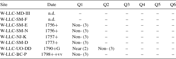
Although, for brevity, we focus on the westernmost sites, it should be noted that the presence of eighteenth-century Navajo sites east of Chinle Wash supports the western migration hypothesis, which would predict late eighteenth-century Navajo sites in this region as Navajos gradually moved west from the Dinétah. However, using the methods delineated in this paper, our analysis demonstrates that we should have little confidence in the simple assertion of absolute dates of sites on Black Mesa as characterized by NLC archaeologists. Researchers dated all but one of the sites with noncutting specimens, and none of the sites exhibit a clustering of dates (Table 7). Gilpin's (Reference Gilpin and Towner1996:171) claim that the Navajo occupied areas as far west as Black Mesa in the 1700s remains unproven using dendrochronological data and, indeed, current tree-ring data indicates a Navajo history of settlement that begins up to a century later than Gilpin asserts.
Sites with Associated Tree-Ring Data, Claimed by Gilpin to be Eighteenth-Century Navajo Sites on Black Mesa.

We suggest that our approach provides a clear mechanism for evaluating the validity of claims of early Navajo settlement based on tree-ring evidence. As shown in this study, to be convincing, any such claim should follow these criteria: tree-ring dates should be cutting or near cutting, they should cluster, they should come from freshly cut wood elements and structures that tend to use freshly cut wood, they should come from diagnostically Navajo structures or sites, and there should be additional material evidence that corroborates the presence of Navajo social agents. This approach builds on other studies, which have not taken tree-ring dates at face value but critically used tree-ring data in junction with other dating techniques (Dykeman et al. Reference Dykeman, Towner and Feathers2002) and consider tree-ring data one strand in a tapestry of evidence (Sesler et al. Reference Sesler, Hovezzk, Wilshusen, Wilshusen, Hovezzk and Sesler2000).
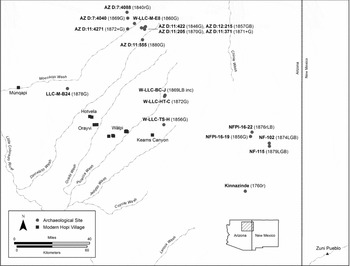
The tree-ring dates produced by the NLC, BMAP, and other archaeological projects are congruent with the research that indicates a Navajo westward migration from the Dinétah (Figure 11). The Navajos seemingly first moved into the upstream, eastern sector of the Little Colorado River watershed in Arizona around the mid-1700s. At this time, the Navajos occupied a defensively located and fortified pueblito, securely dated to A.D. 1760, suggesting that their entry into the region was contested. Based on the tree-ring evidence, in A.D. 1840, Navajo settlements began on Black Mesa and continued through the 1880s, while in the 1850s Navajo settlements moved into the area northeast of Keams Canyon and north of Kinnazinde. The earliest known Navajo settlement west of Hopi securely dated with tree-rings was established in A.D. 1878.
Sites with tree-ring dates produced by the NLC, BMAP, and other projects in northern Arizona, which suggest pre-1882 Navajo settlements.

Given that we have only moderate-to-high confidence in a mere 18 Navajo sites, it seems unlikely that they are a representative sample of the total Navajo sites in the study area. As such, it is unclear whether the dated sites are a vanguard of a gradual expansion or the crest of a wave of westward migrants. New research should seek out sites and further work to combine tree-ring data with other lines of evidence and to consider not just Navajo settlement patterns but also broader land-use patterns (such as hunting and gathering). In short, the magnitude and precise timing of the Navajo expansion and land use across northern Arizona remain uncertain, but the method proposed here should be able to help future researchers establish this history—and, indeed, any regional history—with more certainty than before.
Acknowledgments
We acknowledge the assistance of Leigh J. Kuwanwisiwma at the Hopi Cultural Preservation Office during the research that led to this paper. Review comments by Francis E. Smiley, Stephen E. Nash, and two anonymous reviewers improved the expression of our ideas. Maren P. Hopkins generously provided the Spanish language abstract, which was checked by Maria Fernanda Boza Cuadros, and Saul Hedquist produced the maps. We thank the Laboratory of Tree-Ring Research at the University of Arizona for dating the dendrochronological samples and for curating the tree-ring collections from the Navajo Land Claims, Black Mesa Archaeological Project, and the other projects used in the paper.
Data Availability Statement
The data used in this study were collected at the Laboratory of Tree-Ring Research at the University of Arizona in Tucson, Arizona, and Brigham Young University, in Provo, Utah.