


INTRODUCTION
Meltwater from the glaciers in Great Himalaya constitutes the important water resource in Nepal. Development and effective use of it requires an understanding of the hydrological characteristics of glacier-fed rivers. Similarly, if we can estimate the amount of glacier accumulation and ablation from hydrological observations, the total regimen of the mass balance in the glacier system of a watershed will be estimated.
Hydrological observations were conducted in Langtang Valley (28°13’N, 85°I3’E) 27 August to 26 October 1982, i.e. from late monsoon season to post-monsoon season.
HYDROLOGICAL OBSERVATIONS
Langtang Valley is located in the southern front of the Great Himalayas, called Langtang Himal on the border region of Nepal and China, some 100 km north of Kathmandu: it is the headwater area of the River Trisuli in the Narayani River System. To compare the characteristics of discharges from a large and a small glacialized watershed, runoff was measured in the Langtang Khola (Khola means a river in Nepalese), the main river of Langtang Valley consisting of many glacialized subwatersheds, and the smaller Lirung Khola, one of the tributaries of the Langtang Khola, which is fed only by Lirung Glacier (Yamada and others 1984) (Figure 1). Sites of hydrological observations are located at 3840 m a.s.1. in the Langtang Khola watershed (LAW) and at 4000 m a.s.1. near the end of Lirung Glacier in the Lirung Khola watershed (LIW), Meteorological elements were measured at Base House (BH) in Kyangchen Gompa (3920 m a.s.1.) near the two sites. These sites are respectively marked SI, S2 and BH in Figure I. The total area of LAW was 333 km2, of which 127 km2 (38%) was glacierized. LIW had an area of 13.8 km2, of which 6.2 km2 (45%) was glacierized.

HYDROLOGICAL ANALYSIS
The total amount of runoff r from a glacialized watershed per unit time is given by

Where α is the runoff coefficient; M and P1 are the total amounts of ablation and rainwater respectively. For convenience the quantities will hereafter be considered areal means in a unit of length per unit time.
To estimate the amount of α in Equation 1, a comparison is made between r observed and M estimated in the rainless post-monsoon season when P1 = 0 in both watersheds.
We first estimated M by the degree-day method, given by

The method has been widely used for evaluating snowmelt in mountain basins from air temperature data only ( Yamada 1982, Rango 1983). In this paper we assume simply the value of degree-day factor k being constant. From the map, readings are taken of the glacier area, Ag(z)dz, between altitude z and z+dz, the area A of the watershed, and altitude ze of the glacier terminus. Air temperature Ta(z) is calculated from Ta observed at Base House (BH) and lapse rate r. The temperature Ta(zm) at the altitude zm of the upper limit of the ablation area is 0°C. The value of r is measured in Langtang Valley as 1.0 x 10⁻² on the glaciers and 0.6 x 10²°C/m in the glacier-free area. Constant k was obtained empirically in Nepal Himalaya, by linear extrapolation in Figure 6 of Ageta and others 1980, with a value of 10 mm/degree-day.
It was found that r = M in LIW, and r = M + l.7mm/day in LAW, especially after 20 September, when the post-monsoon season started, as shown by thick solid line (r) and dashed line (M) in the upper (LIW) and the lower figure (LAW) of Figure 2. In the lower figure, the residual (r - 1.7 in LAW) is shown by the thin solid line.

Paying attention to the result obtained in LIW, it is clear that évapotranspiration E and the change in groundwater storage G are negligibly small; that is, runoff coefficient α in Equation 1 is approximately equal to 1; of rainwater runoff is also believed to be 1. The hydrological characteristics, E = 0 and G = 0 seem to be reasonable in LIW, because of comparatively low air temperature and absence of a vegetative cover in Langtang Valley catchment, where the groundwater basin resulting from active movement of Lirung Glacier, and steep neighbouring unglaciated slopes, have little or no sedimentary covering. As for LAW, the value of 1.7 mm/day may imply daily runoff due to the change in groundwater storage, this value being comparatively large in comparison with the value of r in the postmonsoon season. The groundwater basin in LAW may consist of the abundant sediment accumulated in the bottom of the large U-shaped Langtang Valley, in which a large amount of water has been contained as groundwater during the monsoon season.
The watershed LAW consists of many glacialized subwatersheds, each with hydrological features similar to those in LIW, because of topography and sediments. From LAW almost all the ablation products and rainwater are believed to discharge into the Langtang Khola, the main river of Langtang valley, and α = 1 as in LIW.
The relation of P1in LIW and LAW to the amount of precipitation R measured at BH is presumed to be

Rainfall area A1defined as the area where Ta>2°C because of the probability of rainfall being 50% at 2°C (Higuchi 1977), is derived from the map and Ta observed at BH. As the difference r-M obtained in the monsoon season agrees with P1 calculated from Equation 3, the best-fit value of correction factor β is determined as β =1 by trial and error in both the watersheds. Values of P1 are added to those of M in figure 2, giving the dotted areas.
MASS BALANCE OF THE GLACIER SYSTEM IN LANGTANG VALLEY
Investigation was made of the mass balance of the glacier system in LAW, the first attempt in this region, from data of monthly precipitation RM and monthly mean air temperature TM at Kyangchen Gompa (BH), estimated by Ageta and others (1984).
Accumulation Ps is estimated in the same way as P1
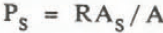
where As is the solid precipitation area, TM<2°C in LAW on the assumption that almost all solid precipitation that falls on the glacier-free area avalanches into the glaciers. Since Ageta (1976) has shown that 30% of precipitation occurs in the daytime (06-18h) and 70% at night (18-06h) in the deep valleys of Great Himalaya, day and night accumulation are calculated separately using monthly mean daytime (TMD) and nighttime (TMN) air temperatures estimated from TM. Estimation is made by adapting TMD and TMN to TM, evaluated from air temperature data measured at Lhajung (4420 m a.s.l.) in the Khumbu region (Appendix in Seppyo 40, 1978), assuming harmonic diurnal variations,
Daily ablation M in LAW is empirically related to daily mean air temperature Ta at BH, using Equation 2. From this relation, values of M are estimated from TM for each month of the year assuming that the above relation obtained from daily values of ablation and air temperature can be adapted for monthly values.

Figure 3 shows seasonal variations in accumulation, ablation and balance (hatched histograms) in the glacier system of LAW, 70% of accumulation occurred in the monsoon season from June to September. Monthly mass balances are negative and large from April to June. In conclusion, annual accumulation and annual ablation are roughly estimated at 1800 and 2200 mm respectively for the LAW glacier area. Since annual balance of a glacier should in general be close to zero, annual accumulation and annual ablation may fall in the range of 2000 ± 200 mm in this region. The discrepancy between estimated values of accumulation and ablation may be caused by the large number of assumptions. Though we have no data for judging whether our values are reasonable or not, the sum of ablation (820 mm) and annual amount of rainfall (340 mm) over the whole LAW, ie 1160 mm of annual runoff, agrees fairly well with annual measured precipitation of 1009 mm, assuming a negligibly small annual change in groundwater storage. This suggests that our method is reasonably accurate.



