

In my visits to China and Japan, and to Siam, Java and Bali, I felt profoundly moved to find how the communion of our cultures had persisted even up to our own days (. . .). [O]ur peoples have maintained an Asiatic tradition of cultural exchange; we have not fought with each other in the name of hungry nationalism as the Western countries have been doing in Europe. Japanese aggression [in China], therefore, seems to me essentially a case of borrowed pugnacity . . .
– Tagore to Nehru, August 1939.Footnote 1
I
It is now widely rumoured that the ‘Asian century’ is upon us. But what does this really mean? As late as 1988, Deng Xiaoping—in remarks made before the Indian prime minister, Rajiv Gandhi—expressed some scepticism about the facility of the formulation. As Deng stated then:
In recent years people have been saying that the next century will be the century of Asia and the Pacific, as if that were sure to be the case. I disagree with this view. If we exclude the United States, the only countries in the Asia-Pacific region that are relatively developed are Japan, the ‘four little dragons’, Australia and New Zealand, with a total population of at most 200 million. (. . .) But the population of China and India adds up to 1.8 billion. Unless those two countries are developed, there will be no Asian century. No genuine Asia-Pacific century or Asian century can come until China, India and other neighbouring countries are developed. By the same token, there could be no Latin-American century without a developed Brazil. We should therefore regard the problem of development as one that concerns all mankind and study and solve it on that level. Only thus will we recognize that it is the responsibility not just of the developing countries but also of the developed countries.Footnote 2
Whatever the doubts about his standing as a Marxist, then, we may say that Deng remained resolutely universalist in his perspective, at least outwardly.
In the 1990s, however, with the fall of the Berlin Wall and the progressive collapse of the Soviet bloc, rhetoric for the ‘Asian century’ began to take a more strident turn, emanating especially from Southeast Asia. This was initially linked to the development of the paradigm of ‘Asian values’ promoted from Malaysia and Singapore; it consisted largely of a form of neo-Confucianism, allied with a velvet-glove political authoritarianism, and the view that in Asia individual freedoms were normally to be subordinated to the collective good of family, community, and state. One of its most outspoken proponents was the prime minister of Singapore, Lee Kuan Yew, while a variant version was espoused in Malaysia by Mahathir Mohamad.Footnote 3 The success of this thesis was limited; it soon came under sustained attack, with Amartya Sen stating, rather bluntly, for example, that he did not see ‘the usefulness of a grand contrast between Asian and European values’, and that such ‘a grand dichotomy between Asian values and European values adds little to our comprehension, and much to the confusion about the normative basis of freedom and democracy’.Footnote 4 But the proponents of the ‘Asian century’ have since returned to the charge, with new tactics, devices, and arguments, including some drawn from currents such as ‘post-colonial studies’. The Taiwanese intellectual Kuan-Hsing Chen, for example, recently published a work with the provocative title Asia as Method (derived in turn from Takeuchi Yoshimi), in which he argues that the need of the hour is ‘deimperialization, decolonization, and de-cold war’, which is to say liberation from an excessive American influence over Asia that came about in the course of the Cold War.Footnote 5 But the principal means of this liberation is seen as resorting to a pan-Asian rhetoric, that draws both from the troubled legacy of inter-war Japanese intellectuals (and in particular Sinologists), and more recent demi-gods of the post-colonial pantheon, whose version of ‘Asian values’ or ‘left-leaning populist civilizationalism’ (in Chen's happy phrase) seems often to include a crude rejection of history itself.Footnote 6 This of course leaves open several questions. For whom is ‘Asia’ meant to be method: for all Asians, for some Asians, or for some non-Asians as well? And what does this method consist of, besides the broad denunciation of imperialism and neo-imperialism, and the adoption of a post-colonial literary theory (much of which happens to come out of the American academy)?
These are questions that I will return to, in a modified form, while concluding this article. But let me begin instead with a different one, which will run like a thread through these pages: one Asia, or many? My own intermittent reflections on the question of historical boundaries, geographical categories, and their fixity or porosity began early in my career—when I was doing my doctoral thesis in Delhi over three decades ago, and being pushed, like the mythical Trishanku (from the bāla kānda of the Rāmāyana), in opposite directions by two very different advisers, one an archivally focused historian of early modern Dutch trade in Asia, the other an agrarian historian and voracious reader of everything from Fernand Braudel to Arthur Waley.Footnote 7 A crucial meeting for me occurred when I was visiting the archives in England in early 1985, and was invited for a visit to St Catharine's College by the late C.A. Bayly. Bayly had recently published his magnum opus, Rulers, Townsmen and Bazaars, a book that contained crucial insights and arguments that deeply marked my generation of scholars of South Asia, especially those concerned with the twin issues of trade and state-building that were at the core of my thesis. When I returned to Cambridge three years later for a postdoctoral fellowship in Clare Hall—in which I rather suspect Bayly had more than a marginal role to play—he was putting the finishing touches on a rather different book, Imperial Meridian.Footnote 8 Though ostensibly a history of the second British empire, the book in fact had far larger ambitions, and taught historians of South Asia—at least some of them—how to think outside the geographical box, as it were.Footnote 9 Bayly had read widely for this book on the histories of West Asia and Southeast Asia, drawing on the work of Roger Owen, Peter Gran, Peter Carey, and so many more. Equally, he reached, though in a more limited way, into the histories of Central Asia and East Asia. As an intellectual project, it certainly profoundly influenced both the form and content of my own Portuguese Empire in Asia; and it is no coincidence that the two books even appeared from the same publisher, Longman, within four years of each other.Footnote 10 I should begin this reflection on Asia then by acknowledging this debt, while knowing that I am only one of many who are indebted in this way.
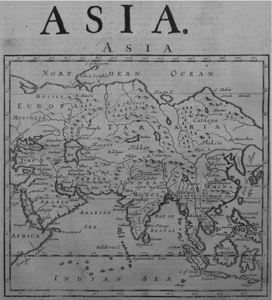
I must obviously also acknowledge a debt to the editors of Modern Asian Studies for their very kind invitation. It is all the more kind because I do represent in some measure a rival journal—the Indian Economic and Social History Review from New Delhi which was founded in 1963, four years before Modern Asian Studies first appeared. But the rivalry has always been a friendly one, and softened moreover by the differing coverage of the two journals, the one focused on India (or more correctly South Asia) and limited to history, the other with a far larger geographical and disciplinary scope.Footnote 11Modern Asian Studies thus more closely parallels its transatlantic cousin, the Journal of Asian Studies, which first appeared in 1956 and replaced the older Far Eastern Quarterly, itself founded in the year of the attack on Pearl Harbour. What is the ‘Asia’ of these two journals? Apparently not that of the Journal of the Royal Asiatic Society or the Paris-based Journal asiatique. A look at the very first number of Modern Asian Studies should help us understand the difference. Here, we find essays by J.H. Beaglehole and Percival Spear on India, an article each on rural Malays and the Japanese Samurai, and a review essay by Owen Lattimore on Mongolia. Cyril Philips contributes a short essay on how ‘modern Asian studies’ developed in the United Kingdom in the aftermath of the Hayter Committee Report of 1961, but does not choose himself to define Asia. Reviewing the first number in the SOAS Bulletin, Hugh Tinker remarked that it symbolized ‘the ‘coming of age’ of the social sciences in Britain in their application to Asia, but he too did not enter into the limits of Asia. We can nevertheless see from the first number that the geographical scope of Modern Asian Studies certainly ran from Japan to India and Pakistan—but what of regions to the west of Afghanistan, whose current president, the anthropologist Ashraf Ghani, incidentally published an essay in the journal in 1978 on ‘Islam and State-Building in a Tribal Society’?Footnote 12 If my own experience with the Journal of Asian Studies is any indication, they draw a longitudinal line somewhere near Gwadar (let us say at 62° E), excluding all subjects to the west thereof. In 1992, I was somehow able to smuggle an essay entitled ‘Iranians Abroad’ under their radar, but when I tried again a year later with an essay on imārat and tijārat (or state-building and trade) in the western Indian Ocean, the doors were firmly shut in my face. I was advised to try a generalist journal, with no geographical boundaries, which is what I eventually did.Footnote 13 For the purposes of The Journal of Asian Studies then, the western Indian Ocean was not a part of ‘Asian studies’, a position that the editors of the Journal asiatique would find strange. (See Figure 1.)
Herman Moll, ‘Map of Asia’, from The Compleat Geographer (1709).

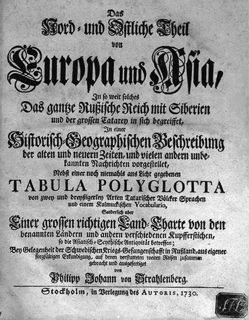
How then does one begin thinking about the ‘idea of Asia and its ambiguities’, to borrow a phrase from the well-known Chinese scholar Wang Hui?Footnote 14 In my view, it may be a good idea to begin with the visual. We may recall, at the outset, that in the play between the -emic and the -etic, the insider's and the outsider's perspective, a concept like ‘Asia’ falls decidedly on the side of the -etic.Footnote 15 Though it is of contested etymology, we know that the term was regularly employed by the Greeks to describe their eastern neighbours in an early scheme of alterity; thus Herodotus writing the Histories in the fifth century BCE already had a fairly good knowledge of what he defined as the western part of Asia, that is Anatolia and perhaps the area around the Sea of Azov, based in part on his own travels, though he stated interestingly enough: ‘As far as India, Asia is an inhabited land; but thereafter, all to the east is desolation, nor can anyone say what kind of land is there.’ The late eighteenth-century colonial hydrographer and cartographer James Rennell traced the Greek understanding of Asia through from Herodotus to Alexander and beyond.Footnote 16 As he was well aware, the Romans inherited this conception of a three-continent scheme—Europe, Asia, and Africa—from the Greeks, but modified it somewhat. The Roman province of Asia, for example, was under proconsular government from the time of the late Republic, and was essentially made up of what would today be parts of Turkey and Greece. Thus, for them there were two Asias: a smaller part under their rule, and another far larger part outside of it. The westernmost boundary too appears to have remained unstable: if at times it was seen as lying within Anatolia, or at the Dardanelles, at other moments it moved further west into the Aegean; eventually, in later Roman times, it often came to rest on the river Don. It was only in the eighteenth century, and Von Strahlenberg's Das Nord- und Östliche Theil von Europa und Asia of 1730, that the current division at the Urals came to be proposed and then widely accepted, with this German-Swedish geographical project flattering the Russian desire to be largely included within Europe.Footnote 17 (See Figure 2.)
Von Strahlenberg, Das Nord- und Östliche Theil von Europa und Asia, title page (1730).
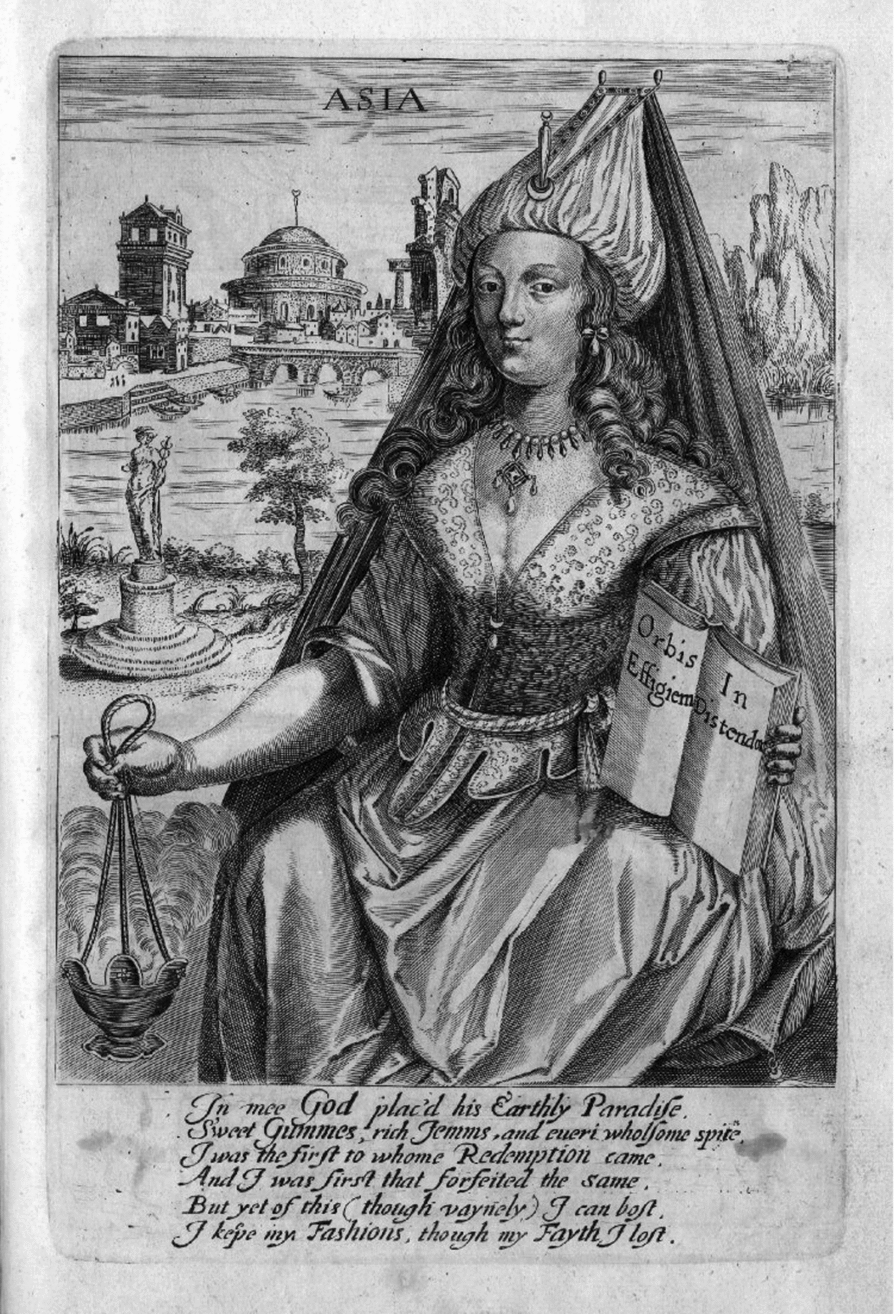
The most common personifications of ‘Asia’ come to us from the period after 1500, when the three-continent scheme had had to be modified, on account of the inclusion of America, to become what the French would term les quatre parties du monde.Footnote 18 The sixteenth and seventeenth centuries saw a number of prints and even paintings, either with the four parts portrayed separately, or in a unified hierarchical scheme, with Europe—naturally—often depicted receiving homage from the other three. ‘Asia’ for artists and printers from the Low Countries like Adrian Collaert or Maerten de Vos is thus usually a woman, riding on a camel or an elephant, or at any rate accompanied by these and other exotic animals. She often carries a large, smoking incense burner, and may be surrounded by costly products such as spices and aromatics. In 1634, the London printer John Stafford added an explicit gloss, in the form of a poem by George Wither to accompany the image (see Figure 3), in which Asia herself speaks as follows:
John Stafford, Asia, from an allegory of the continents (1625–35). Source: The British Museum, London.
Such a view of a largely faithless Asia would be confirmed in influential works such as Cesare Ripa's emblem book; in its eighteenth-century German reworking from Augsburg, that faithlessness is explicitly understood to be a complicity with Islam.Footnote 20 Though superficially attractive, and taking the form of a bejewelled woman, the reader (who is naturally meant to be European, and presumably male) is warned to beware of her temptations. Even when the gender of the representation changes, as with Tiepolo in his ‘Apollo and the Continents’, elements of the exotic iconography—such as the elephant—as well as the references to vanity and luxury persist, combined with some gestures in the direction of acknowledging a vast—if inefficient—military might that lurks just off-stage.Footnote 21 Elements of Stafford's and Wither's conception survived, incidentally, even until as late as the mid nineteenth century, as we see from the English Evangelical writer Favell Lee Mortimer's Far Off, Or, Asia Described (1849–52). Mortimer, a best-selling author in her lifetime, whose books were particularly imposed upon children (despite, or perhaps because of, the allegedly sadistic character of much of her writings), made it clear to impressionable young minds that while both Adam and Jesus were from Asia, all that was in the past and ‘there are [now] very few Christians in Asia, compared with the number of heathens’.Footnote 22
Thus far we have seen Asia as a term of alterity, as a device with which outsiders played, especially in order to differentiate Europe and Europeans from their others to their east. Can we actually identify a moment from which groups or polities began to speak of themselves as Asian, or as belonging to an entity termed ‘Asia’? I cannot say with certainty, but my current guess is that this may have begun in the late seventeenth or early eighteenth century. A good place to begin is with a celebrated instance of print, namely Ibrahim Müteferrika's version of Katib Çelebi's Cihānnümā (or ‘Mirror of the World’).Footnote 23 Himself born in around 1674 in present-day Romania, though he was an ethnic Hungarian, Müteferrika converted to Islam and had a successful career as an Ottoman diplomat, before turning to print. Throughout the 1730s, his press produced over a dozen works, including texts by Seyyidi ‘Ali Re’is, the Ottoman traveller and admiral from the sixteenth century, as well as a piece of early Ottoman Americana, the Tārīh-i Hind-i Garbī.Footnote 24 The experiment eventually ended shortly before his death, perhaps on account of opposition from the class of scribes, who feared—no doubt rationally—that print might put them out of business. But in the process, Müteferrika did manage to provide posterity with some rather interesting maps, which in fact not only drew on Katib Çelebi's mid seventeenth-century work, but also modified and updated it in certain respects. We may note that the original work already bore traces of extensive borrowing from European knowledge (for example, from the Jesuit Giovanni Pietro Maffei's Historiarum Indicarum), itself not unusual in the Ottoman intellectual milieu.Footnote 25 After all, of all the early modern polities, the Ottomans were perhaps the best placed to play the role of a bridge between Islamdom and Christendom (and their respective knowledge spheres)—a great irony given how the Ottomans are regarded in contemporary European political discourse.
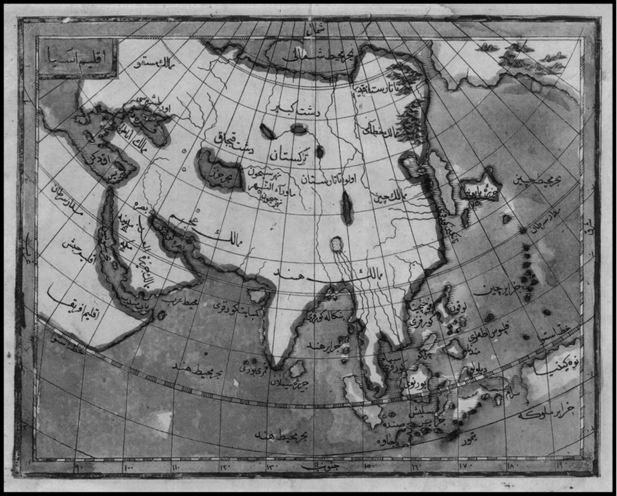
Rather than his world map, however, it is to another of Müteferrika's maps to which I wish briefly to turn now, namely that entitled on its top left ‘Iqlīm Āsyā’. (See Figure 4.) It is a hybrid effort in many respects, already beginning with its title, which takes the older concept of the seven climes (haft aqālīm), and then equates climes with the European concept of continents such as Europe, Asia, and Africa.Footnote 26 However, the place names often draw upon an older Perso-Arabic set of geographical traditions, even if there are some exceptions. Müteferrika's map in fact belongs to a family of similar efforts from the period, which includes a map from 1727–28, discussed at some length by Ariel Salzmann.Footnote 27 The anonymous cartographer describes his own intentions as follows:
Map of ‘Iqlīm Āsyā’ based on Katib Çelebi's Cihānnümā, printed by Ibrahim Müteferrika (1732).
The principal aim and object of this map (harīta) is to render a pictorial and written account in accordance with the principles of the science of geography (fenn-i coğrafya), the clime, or rather the continent (kıta) of, Asia: its countries, towns, territories, seas, mountains and rivers, from the felicitous seat of the abode of the kingdom, the most excellent Konstantiniye, eastward to the lands of Hindustan. And within this expanse [its objective] is [also] to capture to the best of our ability, the breadth and length of the settlements, seas, countries and lands over which the exalted Ottoman state (Devlet-i Âliye-i Osmaniye) rules (. . .) to record in picture and text those of the land of Iran (Iran-zemin) otherwise known as ‘Acem, and those of Turan in the vicinity of the Ceyhun river, as well as Transoxiana (. . .) where today reside the Uzbek, Chaghatay, Turks, Turkmen, and Tatar, and other tribes and clans (kaba’il ve aşa’ir).Footnote 28
As for Müteferrika, he ranges further east, indeed as far as what he terms ‘Yāpūniyā’, clearly identified to the extreme east of the map. I am inclined to identify ‘Lūqūn’ further south from Japan as meaning Luzon rather than the Ryukyu Islands. Of a whole host of identifiable place names, I will only list a handful: ‘Būrnūy’ for Borneo (or Brunei); ‘Sīlān’ preferred over the more traditional Sarandib; the Mamālik-i Chīn (given the dignity of a plural, as opposed to India and Iran); Tātāristān and Turkistān; the Dasht-i Qibjāq; the Bahr-i Khizr (or Caspian Sea); and the Mulk-i Hind and the Mulk-i ‘Ajam. Interestingly, in view of the history of contacts in the sixteenth century, the Sultanate of Aceh finds no place in this map, perhaps a function of its diminished importance by about 1730 for the Ottomans. We may also note that China has been somewhat radically truncated to the east, when we compare it to European maps from about 1700.
In any event, despite his partial indebtedness to both western European cartography in particular, and the Germanophone geographical tradition more generally, it is evident that the approach of Müteferrika—and a fortiori of the anonymous cartographer studied by Salzmann—differs significantly from the long tradition of depicting Asia that was begun by the Portuguese and Italians in the sixteenth century. The core of the textual tradition here lies with authors such as the great Renaissance intellectual and chronicler João de Barros, author of a text in four volumes—the last of which remained unfinished at his death—significantly entitled Da Ásia (‘Of Asia’).Footnote 29 Barros's text came accompanied with no significant maps in its initial version, which is not surprising given how miserly the Portuguese were about sharing cartographic materials in the period. But it did carry in it an astonishing wealth of geographical detail, almost all of it coastal in nature. As the Portuguese fought naval engagement after engagement, and skirmish after skirmish, from Kilwa and Malindi, to Aden, Shihr and Hurmuz, then to Diu, Chaul, Goa and Calicut, eventually reaching the Pearl River delta by way of Melaka and Pasai, Barros—as well as others such as Castanheda, or, more fancifully, Fernão Mendes Pinto—followed their trajectory. When we eventually see the production of some manuscript maps, such as Fernão Vaz Dourado's Atlas of the 1570s, its wealth of coastal information—where every coastal inlet of any strategic importance seems to be listed and named—corresponds to an equal poverty with regard to the interior.Footnote 30 This is a maritime space—os mares da Índia as the Portuguese liked to put it—and it was a vision that the European trading companies of the seventeenth century also inherited in quite large measure.
Further, so far as the Portuguese were concerned, there seems to have been no great desire to distinguish maritime Asia from East Africa, which for them formed a part of the same navigational continuum, and was also comprehended under the same administrative title of the Estado da Índia, the ‘State of the Indies’. To be sure, Barros did inaugurate a certain tradition of approaching Asia—and in particular the Persian-speaking part thereof—through its textual and historical corpus, in which he was eventually followed by Dutch, French, and English savants in the seventeenth century. But was he, or for that matter, Nicolaas Witsen or Olfert Dapper, convinced of the unity of Asia? Witsen, a traveller, collector, and sometime mayor of Amsterdam, wrote a rather prolix and confused text on ‘North and East Tartaria’, which is often understood as separating northern Asian steppe societies and their cultures from others.Footnote 31 But the unity of Asia here seems to me far from certain. Most Portuguese and Dutch intellectuals of the sixteenth and seventeenth centuries in fact had an acute sense of differences within Asia, as well as in the world of the Indian Ocean and China seas. I have shown elsewhere, for example, how the Florentine intellectual Filippo Sassetti, who was employed by the Portuguese in the 1580s, made it clear that one could hardly confound what he termed the ‘black Gentiles’, who he thought lacked intelligence and were only good for manual labour, and the Japanese who were ‘olive coloured people (. . .) who exercise every art with good understanding’; though in the matter of cuisine, he remarked, they were surpassed by the Chinese who ‘likewise exercise all arts’.Footnote 32 Observers like the Jesuit Alessandro Valignano made a great matter of differences in complexion, distinguishing the ‘whiter’ races of East Asia, and in particular the Japanese, from the Indians, Sinhalas, and, above all, the cafres of East Africa. His contemporary and companion in the Order, Luís Fróis was even tempted to propose a systematic reflection on the ‘contradictions and differences in customs (contradições e diferenças de costumes)’ between Europeans and Japanese, an exercise that presupposed a certain level of commonality that was never conceded to most other peoples in South or Southeast Asia.Footnote 33 Cutting across this colour consciousness was a reflection based on religion (or lei, meaning ‘law’, frequently the preferred usage in the period). The simple scheme separating Christians from Muslims (or Moors), Jews, and Gentiles grew immeasurably more complicated in Asia, as the category of the Gentile (or ‘heathen’) grew more and more unwieldy with time. One can divine this by looking at curious texts such as De la Créquinière's Conformité des coutumes des Indiens orientaux avec celles des Juifs et des autres peuples de l’antiquité (1704), on which Carlo Ginzburg and I have written in recent years.Footnote 34
II
There is undoubtedly some distance to be traversed between this situation, and that which emerged in the nineteenth century, when Asia came to be seen as a mosaic of ‘civilizations’. As we know, while the term ‘civilization’ existed and was used as early as the sixteenth century in order to distinguish the civilized from the barbarian (a subject on which Tzvetan Todorov has written extensively of late), it properly emerged into usage in the plural (or as ‘countable’) only after 1800, and gained ground towards the end of the century.Footnote 35 In the twentieth century, two distinct strands can be found in its use as such: one that I find slightly more loose and sympathetic, associated with Arnold Toynbee, and suggesting a large and open-ended number of civilizations in history; and the other, which has come to gain ground and which closely identifies civilizations with a limited number of religious complexes. For the latter, much of the responsibility must be placed at the door of Max Weber and the Weberians, whose blunt-edged formulations on such subjects as ‘pariah capitalism’ were durable red herrings for several generations of scholars of South Asia, for example.Footnote 36
A neo-Weberian reading from the late twentieth century is that of the economic historian K. N. Chaudhuri in his Asia Before Europe.Footnote 37 Chaudhuri admits from the outset that ‘the term “civilisation” is of recent origin’, but argues thereafter that ‘the physical contours traced by the historical development of certain regions, their people and societies leave little doubt that the dialectics of cognitive logic appeared certainly before our period of study’. This peculiar formulation—which teeters uncertainly between the physical and the cognitive—then permits him to argue for the existence across the Indian Ocean region of four civilizations: namely ‘Islam’, ‘Sanskritic India’, ‘South East Asia’, and ‘Chinese’. We are then given a series of further formulations, which can only be termed incoherent at best, concerning why these four categories, as opposed to others, should be treated as ‘civilizations’. As regards Southeast Asia, for example, Chaudhuri claims that there was a ‘strong contemporaneous awareness of a series of separate identities to be perceived and seen in a world of islands and sea, rivers and mountains, in the physiognomy of the people, in their dress, food and houses, in the way of building shrines, in lands that grew sandalwood and aromatic spices’. But he confesses at the same time that he has doubts whether this classification based on an ‘awareness’ constitutes ‘a separate logical space for the purpose of comparative history on the same level as Islam, India and China’. Islam, on the other hand, is for him ‘an abstract identity’, whose ‘geographical zone . . . expanded or contracted according to historical circumstances while retaining its fundamental structural features’. But these structural features themselves seem to elude definition beyond the assertion that they are ‘topological’ in nature. Could the conquest of the Iranian plateau or the expansion into Southeast Asia or the Iberian peninsula actually have left an originary Islam intact? India as a civilization, in turn, corresponds to a historical essence already defined in ancient times around an ‘immense corpus of Sanskritic sacerdotal texts’, as well as ‘invariant principles’ such as varnāshrama dharma.Footnote 38 As for China, its civilizational characteristics were apparently ‘absolute state power’, Confucian ritual, and particular ‘relationships between central government, the civil administration, and the structure of society’.Footnote 39
In sum, Chaudhuri's civilizations seem largely to exist because they escape history, either through textual or conceptual invariance (as with Islam or India), invariance in perception, or invariance in state forms. In short, using the concept of ‘civilization’ tends to lead here down to the path to reification and essentialism. Those in search of some greater comic relief in an essentialist vein can, of course, turn, for a development in this style, to Samuel Huntington's celebrated formulation of the ‘clash of civilizations’, which interestingly has gained great traction among ideologues the world over who wish to see such a clash.Footnote 40 One can see the Urdu translation Tahzībon kā tassādum being eagerly read in the more radical of the Peshawar madrasas, for example, as a road-map for the future. Here Asia is made up of civilizational elements such as the Japanese, the Sinic, the Hindu, the Islamic, the Buddhist, and to a limited extent, the Orthodox Christian. These are civilizations, again in the sense of being essentialist identities expressed through fixed value-systems. One can see why not only critical historians of the concept of religion, such as Wilfred Cantwell Smith, but most historians might have issues with such an ahistorical world vision.Footnote 41 The historian of contemporary Asia will also be surprised to learn that China and Japan, for example, have a very low potential for conflict when viewed through this prism.Footnote 42 On such pearls of wisdom do the Pentagon and State Department function.
Of course, Weber and Chaudhuri did not invent the taxonomy that they used, nor was it of purely European origin. If one turns to a medieval Arabic text such as the twelfth-century Akhbār al-Sīn wa’l Hind, or others in a similar genre, they often speak of four or five great regions: the mulk al-‘Arab, the mulk al-‘Ajam, the mulk al-Hind, and the mulk al-Sīn, to which can be added the Byzantine domains of Rum.Footnote 43 To these can be added two other interstitial regions, namely Mawara-an-nahr (or Transoxiana) and Zirbadat, the ‘Land below the Winds’ (or Southeast Asia). But while these are sometimes political entities, and sometimes cultural zones characterized by certain traits (Hind, for example, being the place ‘of those who pierce their ears’), they do not assume the inflexibility that is supposed in a concept such as ‘civilization’. Nor do Chinese xenological texts on India from the centuries before Ming rule suggest an inflexible notion of an area usually termed ‘Yindu’, after the usage of the seventh-century monk and pilgrim Xuanzang, which had replaced the earlier term ‘Tianzhu’. The decline in importance of Buddhism in India, and the rise to power of Muslims in the region, was a process that certainly percolated into the consciousness of the Chinese literati.
A well-known Weberian sociologist once expressed dismay when I spoke in Heidelberg about the Persianized Hindu elites of Delhi in the seventeenth and eighteenth centuries. Was this Hindu civilization or Islamic civilization, he demanded peremptorily? This same procrustean bed has equally bedevilled other disciplines. A justly celebrated work entitled The Myth of Continents (1997) by Martin Lewis and Kären Wigen produces an excellent critique of ‘metageography’, and insists that ‘world regions’ must be defined not on an essentialist basis, or with some deterministic idea of ‘political and ecological boundaries’, but by taking due account of historical processes, which produce an ‘assemblage of ideas, practices, and social institutions’ that are essential in making sense of regions.Footnote 44 Yet an inspection of their concluding map, with a ‘refined world regional scheme’ can only be a disappointment from this viewpoint for it barely disturbs the map of what they term ‘standard world regions’, or even the standard Weberian scheme of civilizations. Interestingly, the most important single departure is in their introduction of a new role for Central Asia, and it is this that I will take as a point of departure for my next set of reflections.
Central Asia was an important element in the approach to history of a particularly innovative historical thinker of the mid twentieth century, Joseph Fletcher. Fletcher, whose career was unfortunately cut short before he produced the various monographs he promised, nevertheless wrote a series of brilliant essays, as well as chapters (notably in the Cambridge History of China).Footnote 45 In these, he set out a vision (which his students, like R. Bin Wong, inform me he sometimes self-deprecatingly called ‘Joe Fletcher's plane ride’) of what he termed ‘integrative history’, one of the points of departure for my own conception of ‘connected history’. Rather than treating Central or Inner Asia as an intellectual barrier, he suggested vigorously opening out the study of Qing China into Tibet, Xinjiang, and beyond, bringing the world of the Naqshbandi Khwajas of Yarkand and Khoqand into relation with the world of Tibetan lamas and Manchu religious specialists, not on some kind of whim or as an act of intellectual virtuosity, but because this was crucially important in order to understand the political and ideological networks that had existed in the world of the Qing.Footnote 46 Fletcher's lead with regard to some of these matters, notably in respect to integrating the study of Manchu into Chinese historiography, has been followed by the work of many younger historians such as Mark Elliott, Pamela Crossley, and Nicola Di Cosmo.Footnote 47 Still other scholars have actively pursued another of Fletcher's interests, namely the significance of the thirteenth and fourteenth-century Mongols for an integrative history of Eurasia, which goes beyond the conventional regional demarcations decried by Lewis and Wigen. It will now be generally admitted not only by political historians but by those of culture that thirteenth-century Iran must often usefully be studied together with Central Asia and China; writing of the material culture of the Mongol Ilkhanids in Iran, the French scholar Francis Richard has noted, for example, that ‘even if China had been a pole of [cultural] attraction for the Persians even before the Mongol period’, it was the case that ‘in the Ilkhanid period, the phenomenon took on a new dimension’, on account of ‘the regular import, whether by land or by sea, of Chinese objects (textiles and porcelain), and the exchange of embassies’, along with their gifts.Footnote 48 These objects had a significant, in some instances decisive, impact on the directions taken by artistic and artisanal production in Iran in the centuries that followed. The significance of the same period, and of the links with Central Asia and the Mongols, for political institutions and their vocabulary, as well as for the history of land tenure in Iran, has been recognized as far back as the work of Ann Lambton and Vladimir Minorsky.Footnote 49 Not for nothing did Rashid al-Din Hamadani's great chronicle begun under Ghazan Khan, the Jāmi‘ al-Tawārīkh, devote the attention it did to the affairs of Ulus Chaghatay as well as the Yuan Dynasty.
To be sure, we cannot fall into the saccharine myth of what Iranians have re-invented in quite recent times as the jāda-yi abrīsham—the ‘Silk Road’—a term that did not exist in their vocabulary before 1900.Footnote 50 Rashid al-Din, for his part, assured his readers that Chinggis Khan had ‘given the same visage to the whole world, and the same sentiments to all hearts (jahān rā yak rū’ī wa dil-hā rā yak rā’i); he purified the territory of empires by delivering them from the domination of perverse usurpers, and the oppression of audacious enemies’.Footnote 51 In this vision, it would seem that Mongol conquest had less to do with skulls than with hearts and minds. But, as we also know, given the levels of violence that usually attended such conquest, there were also good reasons to attempt to resist if one could. The areas that successfully did resist the Mongols included Japan, Southeast Asia, and India. Khubilai Khan's twin attacks on the Kamakura Bakufu in 1274 and 1281 were of course naval expeditions, and their defeat—not unlike that of the Armada of 1588—was as much the result of weather conditions as of the excellent Japanese system of coastal fortification.Footnote 52 The case of northern India under the Delhi Sultanate is more curious, for here the Mongols were engaged in a more familiar type of expedition and warfare. Nevertheless, despite a series of efforts and temporary successes begun under Ögedei, they were unable to make any decisive gains, with the exception of Kashmir, which they ruled off and on for several decades through various dārūghachīs after their initial conquest in 1235. Though they captured Lahore in 1241, the victory proved to be a pyrrhic one; the Mongol losses were so considerable, including among the highest ranks, that they were eventually obliged to retreat. While Mongol attacks from the northwestern frontier of the Sultanate continued to be a regular (and even annual) feature throughout most of the thirteenth century, and well into the early fourteenth century, there was thus no decisive victory and certainly no lasting conquest.
Why was this so, and what long-term consequences did this have? The analysis by Peter Jackson, which remains the most convincing to date, suggests that we must reject the view that ‘the climate made India an unattractive goal’ for the Mongols and, above all, that they could simply not countenance the heat. Rather, he suggests that a lack of clear geographical divisions between different hordes in regard to the frontier left the Mongols indecisive and fragmented.Footnote 53 Further, even if we reject the most boastful claims of the Delhi sultans’ chroniclers, it appears that the population density of northern India, and the warfare techniques of the sultanate's commanders (strategically deploying foot-soldiers, war horses, and elephants, as Simon Digby has reminded us) were more significant obstacles than the Mongols experienced elsewhere.Footnote 54 As a result, the sultans of Delhi could benefit from a significant inflow of Muslim warriors, divines, and intellectuals from areas freshly conquered by the Mongols, and they maintained some form of relationship to the near-fictive caliphate even after the fall of Baghdad in 1258. At the same time, it is clear that in these circumstances, the forms of intense cultural and material exchange that emerged at this time between Iran and China proved impossible in the Indian case. The Yuan Dynasty's satraps may have looked wistfully towards Bengal from Yunnan, if we can take Marco Polo's uncertain testimony at face value, but there were unable at any rate to act on their ambitions. In some crucial sense, the thirteenth century was thus a moment when India and China turned their backs on each other.
But the matter was revisited in the first half of the sixteenth century. In the interim much dynastic water had flowed under the bridge. The last of the Yuan Dynasty rulers, Toghön Temür had been unable to put down a number of increasingly troublesome rebellions, notably those of the secret society known as the Red Turbans. By 1368, he had had to abandon Khanbaliq (Beijing), and in his place a new dynasty was founded by a former peasant named Zhu Yuanzhang (later termed the Hongwu emperor), namely the Ming Dynasty which was to rule much of China for just under three centuries. At much the same time, Temür, the Turkish warlord of the Barlas clan, emerged into prominence to the west, eventually cutting a swathe that ran from Samarqand to northern India (which he entered briefly in the late 1390s), as well as to the Iranian plateau and even the eastern Mediterranean. After Temür's sudden death in Otrar in February 1405—as he was on his way to attack the Ming—his descendants were unable to sustain the momentum. By the end of the fifteenth century, they were either engaged in bitter internecine battles, or were looking for greener pastures elsewhere. The most successful of them, Zahir al-Din Muhammad Babur eventually relocated to Kabul, and was then able to seize Hindustan from the Afghan Lodi sultans in 1526. Many of Babur's cousins, generically referred to as the ‘Timurid Mirzas’, had far more intricate careers.
A particularly intriguing case among these cousins is that of Mirza Haidar Dughlat, a highly successful general and military entrepreneur who was also the author of a somewhat neglected first-person text in Persian entitled the Tārīkh-i Rashīdī. Mirza Haidar was born in Tashkent around 1499 in a clan closely related to that of Babur's lineage, but which saw itself as quite distinct in its ambitions in many ways.Footnote 55 He spent the first years of his life in close personal proximity to Babur, for whom he expresses great admiration, but then chose from his mid-teens to place himself in the service of another important Timurid clan, that of Sultan Sa‘id Khan to the east. Over the next two decades, he then fought more-or-less ceaselessly for this patron in the area between Kashgar and Khorasan, but often extended his operations southwards into the Tibetan plateau as well. This altogether exhausting form of high-altitude campaigning with small forces and high casualty rates took the Mirza across the Pamirs on more than one occasion. In 1531, he invaded Ladakh, Tibet, and western Kashmir on behalf of his patron, in what he termed in his text a form of jihād against prosperous and powerful infidels. Again, in 1533, he mounted an attack on Lhasa, which he had understood possessed considerable riches on account of its density of Buddhist monasteries, but was eventually forced back by the poor logistics of his force.Footnote 56 However, when his chief patron Sultan Sa‘id died in 1533, in the course of these strenuous mountain campaigns, Mirza Haidar began to anticipate with some trepidation that a powerful warlord like himself would not be treated well by his successors. Rather than test the muddy waters of loyalty, he therefore chose exit as a better option. After a complex set of dealings and negotiations, he managed in 1536–37 to attain Badakhshan, and then Kabul, from where he sought to revive his far older dealings with the lineage of the now-deceased Babur. His initial contacts were in Lahore, where in 1538 he entered briefly into the service of Mirza Kamran, Babur's younger son and the rival of Humayun. Then in 1539, he entered the service of Humayun himself and fought briefly at the latter's side in his disastrous campaign in the Gangetic valley against the Afghan-led armies of Sher Shah Sur. After Humayun's defeat at Kannauj, Mirza Haidar proposed a retreat to the north in the direction of Kashmir with which he had some earlier familiarity. When the Mughal ruler chose otherwise, Haidar Dughlat himself marched north, and in November 1540 he re-entered Kashmir with a force, and took it over with very little initial resistance. It may have been as if he was revisiting the terrain of his distant Mongol ancestors.
Over the next decade, and until his death in battle in 1551, his activities in Kashmir remain quite enigmatic. Initially, he seems to have chosen to present himself as a mere ‘regent’ to one of the claimants to the throne in Kashmir, Nadir Shah. Thereafter, from the mid-1540s, he issued coins in the name of Humayun and seems largely to have acted in his name, even though the Mughal ruler was absent in these years, first in distant Iran and then in the Kabul region. In this same period, as discontent with his rule grew, Mirza Haidar was obliged to defeat various rebellions mounted either by members of the displaced Kashmir dynasty or by other powerful local warlords. One narrative presents him as a ruler whose intolerance grew apace with time and power, and who increasingly revealed himself as an orthodox Sunni Muslim of a Hanafite persuasion, and therefore quite unable to stomach the heterodox Sufi-inflected Islam of the region, as incarnated in particular by the Nurbakhshiya order of mystics.
It is thus convenient, no doubt, to contrast Babur and Mirza Haidar and their texts from a number of viewpoints, starting with the linguistic: Babur's text is written in eastern Turkish and that of his cousin in Persian. Further, if the former author appears flexible, pragmatic, and human (and even ‘humanistic’, as some of his recent apologists have it), to which one can add his metrosexual self-presentation as a further virtue, the latter can easily be presented as the bigoted Sunni from eastern Mughūlistan, the failed country-cousin of the cosmopolitan dynast.Footnote 57 In this process, however, we may sell Mirza Haidar considerably short. In fact, even if the Tārīkh-i Rashīdī borrows extensively from other texts—as its author himself freely admits—the attitudes and perspectives it captures cannot be quite so easily dismissed, nor indeed can his wide geographical horizons and connections. These attitudes are, moreover, not simply those of a nostalgia for a Central Asia from which the author found himself in exile. The text of the Tārīkh-i Rashīdī, we may recall, was written while Mirza Haidar was in Kashmir in the 1540s, even though he says less about that region than his modern readers might have wanted.
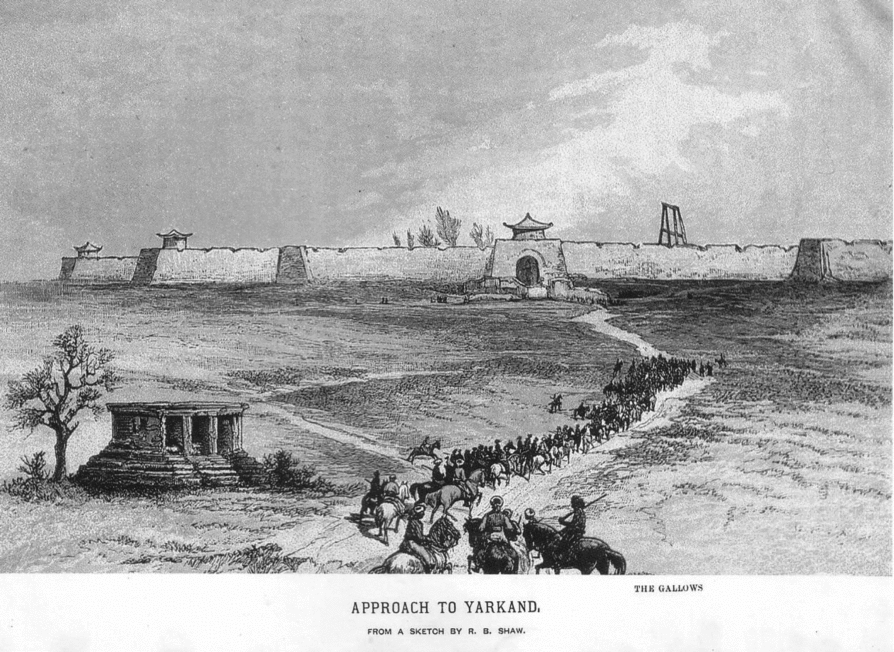
Babur of course saw himself as a Timurid, and also as a Chinggisid; on the other hand, Mirza Haidar saw himself as a Mughūl, and a native of a region he termed Mughūlistan, though he also sometimes identified with the Qara-Khitai—an older usage.Footnote 58 He noted that when he was born in around 905 H. (or 1499), the towns in his native region were in poor shape, and that most of his fellow-Mughals ‘had never lived in villages; indeed, they had never so much as seen a settlement, “A group like beasts of the mountains”’.Footnote 59 This referred then to the easterly groups, in contrast to the more fortunate, prosperous, urbanized, and settled westerly Timurid lineages to which Babur belonged. But Mirza Haidar's native world was really that of Kashgar and Yarkand, as we see from the Tārīkh-i Rashīdi, where he expresses his regret that he has to abandon that land through the force of circumstance. (See Figure 5.)
Robert Shaw, Sketch of Yarkand, from Visits to High Tartary, Yarkand and Kashgar (1871).
Just as it [Kashgar] had advantages, it has disadvantages too. At the beginning of spring constant dark, black, adverse winds full of dust and grit blow. Although Hindustan is famous for this, it happens even more in Kashgar and Yarkand. Agriculture is laborious and bears little produce. In Kashgar it is impossible to maintain an army on one harvest. In comparison with the Qipchaq steppe and Qalmaq, Kashgar resembles a city; but relative to real cities, it is as hell compared to purgatory.Footnote 60
Here, Mirza Haidar rather charmingly quotes a verse from Shaikh Sa‘di's Gulistān to telling effect.
Still, in Mirza Haidar's imagination, the area around Kashgar and Yarkand was once prosperous; he writes that ‘in ancient times there were great cities [in these wastes, but] (. . .) all have sunk beneath the sands’. He even adds the claim that ‘some hunters who go to hunt wild camels relate that occasionally buildings of a city are uncovered, but when they return after a time there is no trace, and they have sunk back beneath the sands. There were such cities, but of them neither name nor trace remains (nām-o-nishān-i ū bāqī nīst)’. Indeed, only Yarkand seems to retain some vestiges of its former glory in his eyes, and he tells us briefly of its impregnable high citadel, with ‘lofty and charming buildings’ and ‘gardens in which lofty structures have been built, each of which contains a hundred rooms, more or less’. Yet despite its excellent water—‘the best in the world’—and superb fruit and roses that were ‘better than those of Herat’, it would seem that even Yarkand is a place that by the early sixteenth century was a pale shadow of what it once was.Footnote 61 In sum, Mirza Haidar seems in the final analysis to congratulate himself for his relocation to Kashmir, which he notes ‘is among well-known countries of the world [and] (. . .) famous throughout the world for its various delights’. Writing in the mid-1540s, a few years before he was killed, he expresses his contentment at ‘the delightfulness and verdure of its gardens, meadows, mountains, for the pleasantness of its weather throughout the four seasons, and for perfect temperateness, no place like Kashmir has ever been seen or heard of’.Footnote 62
Yet eventually men like Mirza Haidar were unable to bring their considerable knowledge of Yarkand and Kashgar, as well as Tibet, to the court of the Indian Mughals, who remained woefully in the dark about those parts of the world. We may say that his mental map ceased to have any validity for them. Five years after his death, Babur's grandson Akbar came to the throne in Delhi, and we find little evidence that he was able to tap into the networks of what we would today term southern Xinjiang (or what some scholars call Altishahr) for his own benefit. A good number of years later, while he was visiting Kashmir, Akbar eventually opened correspondence and diplomatic relations with Muhammad Khan, the ruler of Kashgar, and sent him an envoy who was himself of Central Asian origin, by the name of Mirza Ibrahim Andijani. In the letter carried by this envoy, the Mughal ruler declared his eventual intention to send an embassy to the Ming court, and asked the Kashgar ruler to mediate in the matter by providing him with information on a variety of subjects: the sort of religion followed in China, the nature of Ming administration and justice, the principal arts and crafts there, and the strength of Chinese armies.Footnote 63 The answers to these requests—if there were any—have not come down to us, nor do we have details of a great merchant called ‘Fataha’ who was apparently sent out by the Mughals around this time on an exploratory mission to China via Kashgar. Perhaps it was with merchants such as these that the Portuguese Jesuit Bento de Góis set out in 1603 from Lahore, to make his way via Kashgar into western China, where he eventually died in in Gansu province in 1607.Footnote 64 At any rate, we find no further mention of any exchange of embassies between the Mughals and the Ming or Qing courts until 1700. I was therefore puzzled to read in a recent essay by a prominent Indian political scientist that the celebrated French doctor and traveller of the 1660s, François Bernier ‘records in his Travels his surprise at meeting ambassadors from the imperial Chinese court who were utterly vague about the precise limits of their empire and that of the Mughals’.Footnote 65 On verifying the text, it turned out that these envoys, who, according to Bernier, ‘ne connaissaient pas (. . .) les confins de leur État’, came from what he clearly terms ‘les Tartares d’Ouzbek’, in other words, the rulers of Bukhara.Footnote 66
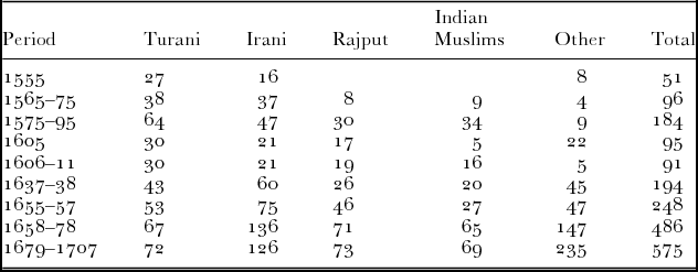
What this effectively meant was that the world to which the Mughals came to relate did not really go northeast beyond Mawara-an-nahr. Even there, after their failed expedition against Balkh in the late 1640s, their interest faded in good measure. To the southeast, they had a fair knowledge of the Malay world and, to an extent, that of Thailand and Burma, in particular the northern region of Arakan. But even in terms of their own elite, the initially high representation of Central Asians (or ‘Turanis’) was progressively diluted as their rule wore on. For their part, over time these men came to complain of how their Mughal masters had become deracinated, and had lost a proper sense of the Chinggisid values (the near-mythical tūrā-yi Chingezī) with which they were meant to rule.Footnote 67 On the other hand, Mughal ties to Iran and to the western Indian Ocean remained strong from the seventeenth and into the eighteenth centuries. An inspection of the changing composition of the Mughal elite gives a sense of this balance (see Table 1).Footnote 69
Composition of upper Mughal mansabdārs, 1555–1707.
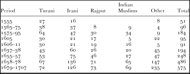
In terms of the cosmopolitanism and diversity of this elite, the Mughals must rank very high in Asian terms, perhaps alongside the Ottomans.Footnote 68 If they were surpassed in this matter, it was possibly by the Prasat Thong dynasty in Ayutthaya in the seventeenth century: here the court was made up not only of native Thais, but also of groups from southeastern China, Bugis from Makassar, a Japanese faction (led for a time by the celebrated Yamada Nagamasa), Shi‘ite Iranians such as Aqa Muhammad Astarabadi, Deccani Muslims, and even the odd Greek from Cephalonia.Footnote 70 On the other hand, we may note that the Mughal court looked largely westward in terms of its elite recruitment.
In other words, if there were some extraordinarily powerful networks and circuits that crossed early modern political boundaries in Asia, whether for political, military or commercial reasons, we must also be aware of the limits of these networks and circuits. Not everything was connected, and not all of the time. Consider the case of the Ottomans, to which we have already referred at some length. Even at the height of their imperial ambitions, in the sixteenth century, Ottoman commercial networks only seem to have stretched as far as India and Central Asia, on the one hand, and southwards to western Indonesia (namely Aceh), on the other. Their dealings with Ming China were largely limited to the intermittent despatch of embassies, beginning in 1524, in which matter they did of course do better than the Mughals. Moreover, in the first half of the sixteenth century, information brought by such embassies as well as the translation into Ottoman of the Khatāy Nāma, the Bukharan savant Sayyid ‘Ali Akbar's text, meant that Ottoman intellectuals had a far clearer sense of post-Mongol developments in China than their Indian counterparts.Footnote 71 At the same time, this information was ‘updated’ only in a rather aleatory and erratic manner, as we can see from the late sixteenth century geographical account of Seyfi Çelebi. The maritime circuits out of India in about 1600, on the other hand, extended as far as the Thai and Malay world to the east, and to the Persian Gulf, the Red Sea, and East Africa to the west. After the cessation of the celebrated Ming voyages of the period from 1405 to 1433, direct maritime contacts between India and China were not maintained for an extended period. As Matthew Mosca has recently noted, ‘by the end of the fifteenth century (. . .) contact between India and China had dwindled. After the return of the last official seaborne mission, private Chinese traders rarely went west of Malacca.’Footnote 72
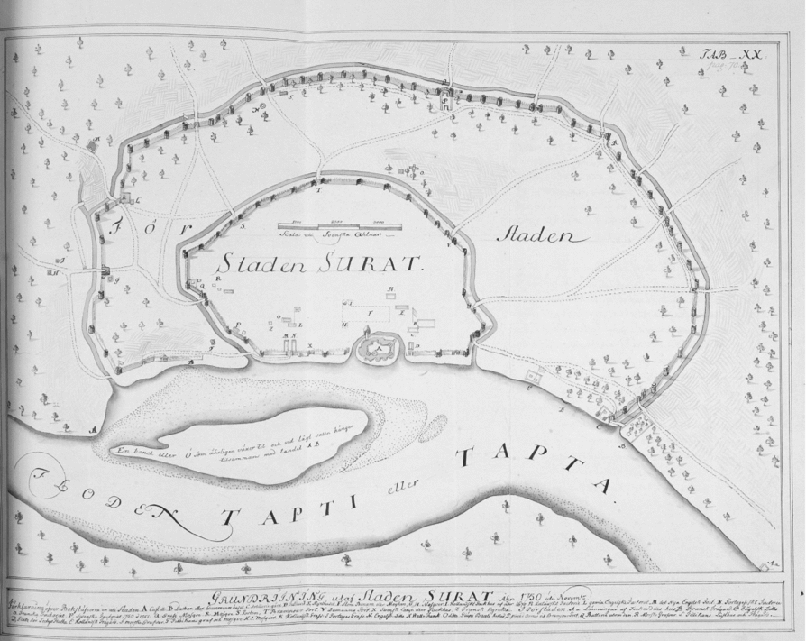
This shrinking appears all the more dramatic when compared to the ever-stronger maritime links between South and West Asia. These were in part driven by the commerce in textiles, horses, and precious metals, and later by new products such as Yemeni coffee. But the Mughal empire also maintained a great interest in the hajj traffic to the Red Sea, which was largely centralized from the Gujarati port of Surat, the Bandar-i Mubārak, or ‘Auspicious Port’, of the Mughals. Many hundreds of pilgrims made this maritime voyage from the Mughal domains each year, besides others who took the more circuitous overland routes. A substantial Indian community existed in the cities of the Hijaz, such as Mecca and Medina; some of them were great savants such as Qutb al-Din Nahrawali, a Hanafite chronicler and part-time diplomat who has left us a number of important texts from the second half of the sixteenth century.Footnote 73 But a closer look at Surat itself again reveals both the extant circuits and the blockages or blind spots. The city, consolidated in the middle decades of the sixteenth century by a former Ottoman subject, Khwaja Safar al-Salmani, was one of the few South Asian ports that was not occupied by Europeans and yet had substantial fortifications in the period. In the seventeenth century, all the major European Companies—English, Dutch, and French—came to have important trading factories there, accepting the terms dictated to them by the Mughals. For the lifeblood of Surat came above all from its other communities, which threw up great trading magnates such as Mulla ‘Abdul Ghafur, whose career was studied in considerable detail—and with unsurpassed panache—by Ashin Das Gupta.Footnote 74 The recent work of Japanese scholars such as Hiromu Nagashima has now enabled us to have a far better sense of how the port's different quarters and inhabitants appeared in about 1700. This is based on the careful dissection of a local map, with legends in Persian and western Hindi, from this period.Footnote 75 The map shows us the presence of quarters, or mahallas, dominated by merchants from the broad region itself, whether Vaishnava, Jain, or Zoroastrian, the presence of Bohras and other Isma‘ilis, of East Africans (or Sidis), of Ottoman subjects from Mosul and Baghdad, of Iranians both from the Gulf and the interior cities, and even men from Central Asian towns like Bukhara. A huge establishment is that of the ‘Aydarusi silsila from the Hadramaut, whose spread across the Indian Ocean is the subject of a recent and well-known study by the ethnohistorian Engseng Ho.Footnote 76 Yet, when one surveys the city one notices that the communities from the east, that is, beyond Melaka, are scarcely present at all. In the mid-sixteenth century, the Surat garrison put in place by Khwaja Safar had included a good number of Malay mercenaries, but these seem to have vanished with time. On the other hand, Surat did periodically reach far into the east; it would appear that in the later seventeenth century, during the reign of the Kangxi emperor, ships of the ‘Muslims of Surat (Sula huizi)’ did appear sometimes in Fujian and Guangzhou. But we are also told that their merchants ‘seem to have kept a low profile and had little contact with Qing officials’.Footnote 77 (See Figure 6.)
C.H. Braad's Plan of Surat (circa 1752). Source: Gothenburg University Library.
A somewhat distinct picture emerged from examining the maritime circuits that connected island and mainland Southeast Asia to India, and especially southern India. The presence of Tamil, or Keling, traders was already noticeable in the Malay world in the eleventh and twelfth centuries, and continued to be the case after the Portuguese seizure of Melaka in 1511—as we see from hybrid Portuguese-Tamil documents of the period.Footnote 78 They came to be linked to, or at times run parallel to, the circuits of cultural exchange that have been analysed of late by scholars such as Ronit Ricci, who examine the passage of materials between the spheres of Tamil, Arabic, and Malay, and between South India, Sri Lanka, and the Malay-Indonesian world.Footnote 79 Taking a longer perspective, one could argue that these are circuits that pick up on the eastern fringes of the ‘Sanskrit cosmopolis’ which Sheldon Pollock has described for the late first millennium CE, and which has left us not only with circulating texts and embedded inscriptions, but whole architectural complexes that seem to traverse the ocean.Footnote 80
To my knowledge, the most powerful attempt to conceptualize these processes for Southeast Asia comes from the pen of the late French scholar Denys Lombard, in his Le carrefour javanais, a work that has neither been translated into English nor really attracted the broader attention it deserves.Footnote 81 In some respects, Lombard's use of the key term carrefour, or ‘crossroads’, enables him to engage in an exercise similar to that carried out by Joseph Fletcher in the case of Central and Inner Asia. Taking Java as his centre, he shows the crucial links to India and West Asia, on the one hand, and China and mainland Southeast Asia (including Champa), on the other. Yet, while these circuits ebb and flow in importance, it is also clear that the function of areas like Java is also to act in some measure as ‘circuit-breakers’. A similar conceptual position may be found in a recent work on China under the Yuan and Ming dynasties by Timothy Brook. While stressing the importance of maritime trade under the Ming, Brook also cautions against exaggerating its seamless transition into any larger circuits. For him, it is thus appropriate to think of a ‘South China Sea world-economy’, which was organized along two axial routes, emanating from Yuegang (or Moon Harbour) and Quanzhou. Using sources such as Zhang Xie's survey Dongxi yang kao (Study of the Eastern and Western Seas) from the 1610s, Brook demonstrates that these circuits effectively ran from Japan and the Philippines to the east, to the Gulf of Thailand and Melaka to the west.Footnote 82 Such a maritime world is also that depicted in part in Japanese cartography of the late eighteenth century, showing the space of circulation between China, the Ryukyu archipelago, and Japan itself.Footnote 83
III
One Asia, or many? The question has been asked many times over the past century, with a variety of answers.Footnote 84 In one of its most recent iterations, it has been debated by two scholars of my own broad generation, Prasenjit Duara and Wang Hui. Duara looks back to the early twentieth century, and the efforts of three intellectuals, namely Okakura Kakuzō (Tenshin), Rabindranath Tagore, and Zhang Taiyan, to build what came to be called ‘Asianism’, that is ‘discourses and ideologies claiming that Asia can be defined and understood as a homogenous space with shared and clearly defined characteristics’.Footnote 85 He suggests that this project was derailed by ‘the Japanese military for imperialist purposes’, but appears to believe that it can be revived in the early twenty-first century. Not only that, he argues that pre-colonial, that is pre-1800, systems of maritime commercial exchange ‘present us with a historical resource to explore new possibilities’. In his view, ‘since at least the thirteenth century, the maritime region from the Red Sea to the South China Sea represented an interlinked system of trade routes’, whose depiction he draws from a secondary literature of rather uneven quality.Footnote 86 But was it in fact a single, ‘interlinked system’, rather than many, shifting systems? We may note, besides, that Duara's Asia—like that of most of the earlier scholars he cites—appears already to run eastwards from India, and also largely ignores Central Asia. It is an Asia that is centred, as it were, for the most part on the Straits of Singapore.
The response by Wang Hui, a Chinese intellectual who is sometimes defined as a part of the ‘New Left’ (a label with which he expresses some discomfort), is salutary. He states quite bluntly that ‘any attempt to characterize Asia as a unitary culture in not plausible’.Footnote 87 Further, he points out, Asia is ‘neither a self-contained entity nor a set of self-contained relations’, so that overstated claims for its conceptual autonomy in either the past or the present must be viewed with considerable suspicion. In his diverse writings Wang Hui is clear that projects of ‘imagining Asia’ in the last century or so have always been political projects, and that it would be naive to think otherwise. A recent examination of such Indian projects in the period before the Second World War concludes—echoing the sceptical view of the literary scholar John Steadman in his 1969 work The Myth of Asia—that ‘“Asia” in this period was a free-floating signifier, a container to be filled with meaning when a particular agenda so required’.Footnote 88 But this may be something of an exaggeration, since a series of constraints did exist on both meaning and signification. Further, it is noticeable that the South and East Asian thinkers of the early twentieth century discussed by Duara inevitably returned to the very distant past, usually depending on the received model of the diffusion of Buddhism to render their Asian space coherent. As Cemil Aydin and others have pointed out, these forms of pan-Asianism therefore logically came into potential conflict with another ambitious movement of the early twentieth century, namely pan-Islamism. It took a great deal of intellectual acrobatics on the part of men like the early twentieth-century Tatar traveller and imam ‘Abdur Rashid Ibrahim (or Ibrahimov) to suggest that the two could in fact be reconciled—for example, if only the Japanese would choose to convert en masse to Islam, and become its vigorous promoters.Footnote 89
While confirming the existence of many complex networks both within Asia and involving Asia, which were created by the imperatives of trade, conquest, or pilgrimage, it has been my contention here that none of these was historically capable over the medieval and early modern centuries of creating anything that resembled a coherent Asian whole. Thus, by 1750, India and China—to take the two most striking examples—remained very poorly integrated, whether one is speaking of culture or material life. It is interesting to note that Prasenjit Duara himself admits as much, by stating that in ‘the nineteenth century, colonial empires, most notably the British Empire, created significant regional interdependencies in Asia’.Footnote 90 The movements of goods, capital, and eventually even military labour that took place between the First Opium War and the Boxer Rebellion brought the two zones together in an awkward embrace that has in the long term not fostered a great deal of either understanding or goodwill. The excellent recent study of Matthew Mosca on Qing relations with India, which I have cited at various points earlier, demonstrates just how tenuous the relations between the two regions remained, and how great the potential for misunderstandings was. Elsewhere, the dominance of the British empire brought other consequences, sometimes placing barriers between regions that had long enjoyed connections and actually participated in the same regime of circulation.
I began by evoking the spectre of the ‘Asian century’. Journalists and diplomats often speak to us nowadays of the inevitable and emergent dominance of India and China, and wonder how these two would-be superpowers of the twenty-first century will come to terms with each other. The historian has a difficult enough time comprehending the past without being asked to pronounce on the future. Still, when I was asked a few years ago to comment on what light history could shed on the persistent lack of understanding that seems to characterize trans-Himalayan relations, I could only point to the fact that for long centuries, the two regions and their dominant state-structures had more or less turned their backs on each other, with only halting and intermittent relations.Footnote 91 So, looking back to the early twentieth century, what is one to make of a powerful and oft-cited passage such as this celebrated one, from the pen of Okakura Tenshin (1862–1913)?
Asia is one. The Himalayas divide, only to accentuate, two mighty civilisations, the Chinese with its communism of Confucius, and the Indian with its individualism of the Vedas. But not even the snowy barriers can interrupt for one moment that broad expanse of love for the Ultimate and Universal, which is the common thought-inheritance of every Asiatic race, enabling them to produce all the great religions of the world, and distinguishing them from those maritime peoples of the Mediterranean and the Baltic, who love to dwell on the Particular, and to search out the means, not the end, of life.Footnote 92
This is the opening of his The Ideals of the East (1904), written in part as a response to those Japanese intellectuals who—after the Meiji Restoration—wanted somehow to extricate Japan from Asia, and take it wholly into the European embrace. Its idealism is clear enough, as is its geographical orientation.Footnote 93 Yet how does Okakura proceed then in his text?
Down to the days of the Mohammedan conquest went, by the ancient highways of the sea, the intrepid mariners of the Bengal coast, founding their colonies in Ceylon, Java, and Sumatra, leaving Aryan blood to mingle with that of the sea-board races of Burmah and Siam, and binding Cathay and India fast in mutual intercourse. The long systolic centuries—in which India, crippled in her power to give, shrank back upon herself, and China, self-absorbed in recovery from the shock of Mongol tyranny, lost her intellectual hospitality—succeeded the epoch of Mahmoud of Ghazni, in the eleventh century. But the old energy of communication lived yet in the great moving sea of the Tartar hordes, whose waves recoiled from the long walls of the North, to break upon and overrun the Punjab. The Hunas, the Sakas, and the Gettaes, grim ancestors of the Rajputs, had been the forerunners of that great Mongol outburst which, under Genghis Khan and Tamerlane, spread over the Celestial soil, to deluge it with Bengali Tantrikism, and flooded the Indian peninsula, to tinge its Mussulmân Imperialism with Mongolian polity and art.Footnote 94
How rapid and astonishing a move then, from a generous and near-universal construction of what we may call a ‘hyperreal Asia’—one based, of course, on an imaginary Indo-Chinese axis—to the swamps of Islamophobia and barely mitigated racist and patronizing stereotypes regarding the Central Asian peoples! So, even if ‘Asia is one’, it is clear that many Asians cannot and do not really belong to it.
One Asia, or many? I believe that by now the reader will have guessed my answer.