



1. Introduction
Determining a vehicle's position is essential for every object tracking and navigation systems. A tracking system can be more successful, which provides a more accurate location at any moment. First, complete control of the system must be prepared to achieve this purpose. Then, one of the navigation systems for tracking and obtaining the final error of the system can be employed. To specify a position in autonomous underwater vehicle (AUV) systems, various methods, such as using the Global Positioning System (GPS), Inertial Navigation System (INS) and dead reckoning (DR) navigation system, are generally applied, each with its limitations (Kayton and Fried, Reference Kayton and Fried1997; Grewal et al., Reference Grewal, Weill and Andrews2007; Chan and Baciu, Reference Chan and Baciu2012; Noureldin et al., Reference Noureldin, Karamat and Georgy2012; Leonard and Bahr, Reference Leonard, Bahr and Xiros2016). With the passage of time, navigation systems have evolved. The newer ones enable engineers to navigate faster and more accurately. These navigation systems have advantages and disadvantages that make none the best for all situations. GPS is a satellite-based radio navigation system. GPS is one of the global navigation satellite systems (GNSSs) that provides geolocation and time information to a GPS receiver anywhere on or near the Earth where there is an unobstructed line of sight to four or more GPS satellites. It operates independently of any telephonic or internet reception. GPS provides users with real-time data based on location, and its signal is available worldwide. The GPS calibration on its own makes it easy for everyone to use. It provides critical positioning capabilities to military, civil and commercial users worldwide. Despite these advantages, the accuracy of GPS depends on a sufficient signal quality received. The GPS signal is affected by the atmosphere, electromagnetic interference, ionosphere, etc., which results in an error in the GPS signal of approximately 10 m (Bakhoum, Reference Bakhoum2010; Gharib and Moavenian, Reference Gharib and Moavenian2014; Gharib et al., Reference Gharib, Heydari and Salehi Kolahi2024). Additionally, GPS does not penetrate solid structures and is affected by large constructions, which means it is useless indoors and underwater or underground. Moreover, the position can occasionally be significantly in error when the number of satellites is limited (Bakhoum, Reference Bakhoum2010; Gharib and Moavenian, Reference Gharib and Moavenian2014; Gharib et al., Reference Gharib, Heydari and Salehi Kolahi2024). Since the inertial navigation method is independent of any external input, it is an autonomous system that does not radiate outside energy. Therefore, it has adequate concealment, and external electromagnetic interference does not affect it (Titterton and Weston, Reference Titterton and Weston2004). One of the major benefits of inertial navigation systems is that they do not need any contact outside the vehicle with the environment (Titterton and Weston, Reference Titterton and Weston2004). However, the positional error increases in this method and the long-term precision is low. Furthermore, a long initial alignment period is required before each use and details regarding time cannot be given (Titterton and Weston, Reference Titterton and Weston2004). The exact values of many parameters can be unknown or have uncertainties since they cannot be measured accurately (Amaral et al., Reference Amaral, Borges and Gomes2022; Campos et al., Reference Campos, Löser and Piovan2023). Therefore, some researchers include uncertainties in their investigations. Junratanasiri et al. (Reference Junratanasiri, Auephanwiriyakul and Theera-Umpon2011) proposed a navigation system for a mobile robot to navigate through an uncertain environment while focusing on dynamic obstacles. To increase the awareness of users about uncertainties, Pankratz et al. (Reference Pankratz, Dippon, Coskun and Klinker2013) used a controlled mixed reality environment to conduct a pilot study. Hacohen et al. (Reference Hacohen, Shoval and Shvalb2017) developed a motion planning method for uncertain dynamic environments. Zhai et al. (Reference Zhai, Wang, Yang and Shen2020) developed a robust modification strategy for an inertial navigation system to overcome the impacts of unpredictable stochastic disturbances in unmanned ground vehicles.
A DR navigation system determines a position by developing a given situation, displacement and distance. This specified position is called dead reckoning. It is generally agreed that the DR position can be determined by displacement and velocity (Cotter, Reference Cotter1978; Fifield, Reference Fifield1979). A DR navigation system operates while the Earth's surface and/or sky is out of reach (Tsakiri et al., Reference Tsakiri, Kealy and Stewart1999; Bevly et al., Reference Bevly, Gebre-Egziabher and Parkinson2006). The inclusion of inertial sensors and advanced DR measurements offers a means to keep the navigation and positioning system on track in some instances where satellites do not reliably measure location (Tsakiri et al., Reference Tsakiri, Kealy and Stewart1999; Bevly et al., Reference Bevly, Gebre-Egziabher and Parkinson2006). A DR navigation system does not need internet or infrastructure, so it works both outdoors and indoors, and is easy to incorporate into any design (Tsakiri et al., Reference Tsakiri, Kealy and Stewart1999; Bevly et al., Reference Bevly, Gebre-Egziabher and Parkinson2006). Despite these advantages, a major drawback of DR is that the errors of the method are cumulative as new positions are determined entirely from previous positions, so the error in the fixed position increases over time (Gebre-Egziabher et al., Reference Gebre-Egziabher, Boyce, Powell and Enge2003; Kumar and Das, Reference Kumar and Das2004; Bevly et al., Reference Bevly, Gebre-Egziabher and Parkinson2006). Additionally, due to its cumulative existence, the error may theoretically be high after a long time (Gebre-Egziabher et al., Reference Gebre-Egziabher, Boyce, Powell and Enge2003; Kumar and Das, Reference Kumar and Das2004; Bevly et al., Reference Bevly, Gebre-Egziabher and Parkinson2006).
Different methods have been developed for position estimation in DR navigation methodology. Aghili and Salerno (Reference Aghili and Salerno2013) calculated a mobile robot's geographical location and orientation using a low-cost inertial sensor and a GPS. Doostdar and Keighobadi (Reference Doostdar and Keighobadi2012) designed a sliding mode observer for a nonlinear MIMO attitude and heading reference system in land vehicle applications. Sabet et al. (Reference Sabet, Daniali, Fathi and Alizadeh2017) designed a low-cost aided DR navigation system for accurate estimation of attitude and heading in the presence of external disturbances, including external body accelerations and magnetic disturbances. An indoor pedestrian DR system based on a pocket-worn smartphone is presented by Zhao et al. (Reference Zhao, Zhang, Qiu, Wang, Yang and Xu2019). The proposed system tracks a person's location through DR calculation by using the sensors embedded in smartphones. Kuang et al. (Reference Kuang, Li and Niu2022) designed a magnetic field matching algorithm based on the relative trajectory and attitude of the smartphone generated by pedestrian DR. This algorithm used the pedestrian DR algorithm to estimate the attitude of the mobile phone in real time. In recent years, machine learning-based techniques have also been integrated with DR method to enhance the accuracy (Brossard et al., Reference Brossard, Barrau and Bonnabel2020; Saksvik et al., Reference Saksvik, Alcocer and Hassani2021; Yan et al., Reference Yan, Su, Luo, Sun, Ji and Ghazali2023). A deep-learning approach to aid DR navigation using a limited sensor suite was developed by Saksvik et al. (Reference Saksvik, Alcocer and Hassani2021). Yan et al. (Reference Yan, Su, Luo, Sun, Ji and Ghazali2023) proposed a coarse-to-fine geomagnetic indoor localisation method based on deep learning.
This paper introduces the DR method to navigate a vehicle position once no external data such as GPS are received. The proposed system is used to determine the position of an autonomous underwater vehicle. The basis of this technique is Newton's equations in classical mechanics. This simulator determines the final location of a vehicle based on the adjustment of its primary position, motion angle and speed data inputs. Furthermore, the proposed algorithm can be used to analyse DR navigation errors based on the definition of error of the gyro sensor, speedometer and different movement scenarios.
2. Navigation and localisation
2.1 Coordinate systems
The final navigation output that most users need to receive includes the coordinates of a point called latitude and longitude as well as their altitude and accuracy (Noureldin et al., Reference Noureldin, Karamat and Georgy2012). Susceptible measurements are performed by an inertial navigation system. For instance, there are three components perpendicular to body rotation axes and three accelerometers, each of which is not directly related to any coordinate system (linear or curvature). These measurements must be integrated analytically and eventually. Therefore, they are converted to the elliptical coordinate system (Wrigley, Reference Wrigley1977; Noureldin et al., Reference Noureldin, Karamat and Georgy2012). As a result, all coordinate systems must be well defined in the measurement transformations and integral outputs. The definition of different coordinate systems associated with an inertial navigation system is given in the next section.
2.2 Inertial coordinate system
A graphic sample for an inertial coordinate system is displayed in Figure 1. This is a summarised definition of an inertial coordinate system for computational purposes. The directions of the inertial coordinate system axes are demonstrated in Figure 1.
Inertial and Earth coordinate systems

An inertial coordinate system is defined as follows:
Centre: in the centre of the Earth
XI axis: towards the average vernal equinox at time T 0
YI axis: a complete right-turn inertial coordinate system
ZI axis: towards the north celestial pole at time T 0
2.3 Earth-Centred-Earth-Fixed (ECEF)
Earth-Centred-Earth-Fixed (ECEF) is a coordinate system that contains the mapping system coordinates. It is not an inertial navigation system and orbits around the Sun at the rate of 7.292115 × 10⁻⁵ rad/s (Kayton and Fried, Reference Kayton and Fried1997; Noureldin et al., Reference Noureldin, Karamat and Georgy2012; Ramesh et al., Reference Ramesh, Jyothi, Vedachalam, Ramadass and Atmanand2016).
The directions of the ECEF axes are demonstrated in Figure 1.
ECEF is defined as follows:
Centre: in the center of Earth's mass
Xe axis: towards the Greenwich meridian on the equator plate
Ye axis: 90° east of the Greenwich meridian on the equator plate
Ze axis: the rotation axis of the basis elliptic
The coordinates in ECEF can be converted with an inertial navigation system by a negative rotation around the Z axis. Essential parameters in the Earth ellipsoid model are shown in Figure 2. The equations related to these parameters will be as follows:


Essential parameters in the Earth ellipsoid model (Noureldin et al. Reference Noureldin, Karamat and Georgy2012)

In the above equations, ‘f’ is the flattening coefficient of the Earth and ‘R’ is the Earth's equatorial radius. Also, Radios East-West ‘R EW’ and Radios North-South ‘R NS’ can be defined as (Kayton and Fried, Reference Kayton and Fried1997; Noureldin et al., Reference Noureldin, Karamat and Georgy2012; Ramesh et al., Reference Ramesh, Jyothi, Vedachalam, Ramadass and Atmanand2016)


where ‘Λ’ is latitude and ‘λ’ is longitude, ‘e’ is the eccentricity of the Earth, ‘R EW’ is Radios East-West, and ‘R NS’ is Radios North-South.
2.4 Local horizon system
The local horizon system is a type of coordinate system known to surveyors as Earth's coordinate system (Kayton and Fried, Reference Kayton and Fried1997; Noureldin et al., Reference Noureldin, Karamat and Georgy2012). If a change is made in ‘X’ and ‘Y’ directions, the velocity of the inertial mapping system is usually defined as components along the axes of the local horizontal coordinate system (Noureldin et al., Reference Noureldin, Karamat and Georgy2012). The directions of the local horizontal coordinate system axes are demonstrated in Figures 3 and 4.
Local horizon system (NEU)

Local horizon system (NED)

The definition of a local horizon system is as follows:
Centre: upper centre
X axis: east of the elliptical curve (also displayed as E axis)
Y axis: north of the elliptical curve (also shown as N axis)
Z axis: upwards along the upright ellipsoid (also expressed as U axis, or Z axis downward displayed as D axis in some Russian books and references)
The conversion matrix between the local horizon and ECEF coordinate systems is as follows:

The angular velocity of the local horizontal coordinate system relative to the Earth can be displayed as follows:


U: Earth's rotation rate
R: Earth's radius
V N and V E: relative velocities of the local horizontal coordinate system with respect to the Earth
h: Earth's ellipsoid height
3. Dead reckoning navigation
Determining the position is the most essential need to be obtained in a moving vehicle permanently and carefully. This is more critical for marine vehicles, which are more restricted than vehicles on the surface (cars, trains, etc.). Thus, several navigation systems must work simultaneously so that the position of a marine vehicle will still be available in case of a system failure (Cestone, Reference Cestone1971; Tsakiri et al., Reference Tsakiri, Kealy and Stewart1999; Leonard and Bahr, Reference Leonard, Bahr and Xiros2016).
DR navigation is a method that can estimate the location of a moving vehicle without needing external data and only based on internal sensors (Filaretov et al., Reference Filaretov, Zhirabok, Zyev, Protsenko, Tuphanov and Scherbatyuk2015; McIntire et al., Reference McIntire, Webber, Nguyen, Li, Foong, Schafer, Chue, Ang, Vinande and Miller2018). The location of a taken course in this method is estimated by starting from a specific point and using classical mechanics rules (Claus and Bachmayer, Reference Claus and Bachmayer2015; Filaretov et al., Reference Filaretov, Zhirabok, Zyev, Protsenko, Tuphanov and Scherbatyuk2015; McIntire et al., Reference McIntire, Webber, Nguyen, Li, Foong, Schafer, Chue, Ang, Vinande and Miller2018).
DR navigation has been in use since the early days of submarine development. Even if there were no other navigation systems today, an AUV would be able to navigate underwater using this method. DR depends on the primary precise fixed position, velocity and passing time parameters (Cotter, Reference Cotter1978). This method determines an AUV's approximate position by continuing the course from the last precise fixed point using the taken courses and calculating the distance by the vehicle speed (Bevly et al., Reference Bevly, Gebre-Egziabher and Parkinson2006). Gyro is needed to achieve the course and speedometer in DR for the submarine's location (Carlson et al., Reference Carlson, Gerdes and Powell2004). One of the factors affecting this method is navy currents. In some systems, the speed of these currents is very effective in the desired movement. Suppose the directions of these currents are completely opposite of a vehicle's movement. In that case, the vehicle's speed will be decreased. In contrast, the vehicle's speed increases when the directions of these currents are in the vehicle's movement direction (Filaretov et al., Reference Filaretov, Zhirabok, Zyev, Protsenko, Tuphanov and Scherbatyuk2015).
Figure 5 demonstrates the status of an underwater vehicle in the presence of steady currents. It moves from its first position at a 75° angle to the north. The point P2 will be the position of the vehicle which is measured by the DR navigation method without the effect of sea currents. The position of P2 is determined by velocity and time. In Figure 5, the line connecting P1 and P2, the direction of the initial vector, and the current speed are called the primary vector and SE current secondary vector, respectively. In the presence of a sea current, P2 moves towards the secondary vector and is transferred to the DR position (P3), which is affected by the vehicle's angle, speed, passing time and sea current. The vector P1P3 is the result of adding vectors P1P2 and P2P3.
Underwater vehicle dead reckoning navigation

It is worth noting that the reliability of DR depends on determining the error at constant body speed and error at heading (Carlson et al., Reference Carlson, Gerdes and Powell2004; Bevly et al., Reference Bevly, Gebre-Egziabher and Parkinson2006; Filaretov et al., Reference Filaretov, Zhirabok, Zyev, Protsenko, Tuphanov and Scherbatyuk2015). These errors are dependent on the accuracy of measuring instruments such as echo sounders, speedometers and gyro (compass).
3.1 Dead reckoning navigation equations
Dead reckoning navigation method equations of an AUV are the equations whose solution leads to an estimate of the current position of the vehicle (Kayton and Fried, Reference Kayton and Fried1997). Another method is inertial navigation, which estimates the current position by taking the initial position of the moving object as well as the accelerations of the object over time (Grewal et al., Reference Grewal, Weill and Andrews2007; Noureldin et al., Reference Noureldin, Karamat and Georgy2012; Gharib et al., Reference Gharib, Heydari and Salehi Kolahi2024). These methods are based on the famous kinematic relations between acceleration, speed and position. Based on these relations, the acceleration integral produces speed, and the speed integral generates position (Leonard and Bahr, Reference Leonard, Bahr and Xiros2016). One of the advantages of DR and inertial navigation methods is that they do not need external data for mobile vehicles from the outside. However, the accuracy of the estimation will increase by correcting navigation errors (Carlson et al., Reference Carlson, Gerdes and Powell2004). Most of the navigation methods can be considered as the processes in which an integral operator leads to provide the outputs (Leonard and Bahr, Reference Leonard, Bahr and Xiros2016). Table 1 displays this issue. In GPS-based position stabilisation navigation systems, integration is unnecessary to convert the sensor output to the position. However, GPS sensitivity can be affected by a number of factors, including the following.
1. Signal blockage: GPS signals can be blocked or weakened by tall buildings, mountains, trees and other obstacles.
2. Atmospheric conditions: GPS signals can be affected by atmospheric conditions such as solar flares, ionospheric disturbances and weather conditions like heavy rain or snow.
3. Satellite position: The accuracy of GPS signals can be influenced by the position of the satellites in the sky.
4. Multi-path errors: GPS signals can be reflected off surfaces like buildings, water and mountains, causing the receiver to receive multiple signals that can lead to errors.
5. Receiver errors: GPS receivers can introduce errors due to factors like clock drift, signal processing and antenna placement.
Integral process in navigation systems

Integrating once in DR and twice in inertial navigation converts the sensor output to the position. These methods to find the position of an object have an essential problem. In these methods, the precision of identifying the vehicle's ultimate position decreases as time passes during navigation.
The practical procedure for solving DR equations involves several steps, which will be described later.
To better understand the concepts in DR, it is necessary to briefly review the relations between the coordinate systems used in this navigation first.
The main equation of DR navigation is the velocity vector equation, which can be displayed as $\overrightarrow p (t )= \int_0^t {\overrightarrow v (\tau )d\tau }$ . Its input is the velocity vector ‘$\overrightarrow v (t )$
 ’ whose components are the velocity components north, south and down. The output of the navigation equation is the position vector ‘$\overrightarrow p$
 ’, which in NED coordinates is the equation $\overrightarrow v = \left[ {\begin{array}{*{20}{c}} {{V_N}}& {{V_E}}& {{V_D}} \end{array}} \right]$
 and the result after integration will be $\overrightarrow p = \left[ {\begin{array}{*{20}{c}} {{p_n}}& {{p_e}}& h \end{array}} \right]$
 , where the components of this vector are the coordinates of north, east and height, respectively. The velocity vector in the body coordinate system has to be converted to the velocity vector in the geographical coordinate system. This is done with the use of direction cosine matrices. Suppose that the velocity vector in the body coordinate systems $({{{\vec{V}}_{\textrm{Body}}}} )$
 and in the geographical coordinate systems $({{{\vec{V}}_{\textrm{NED}}}} )$
 are as follows:


In these relations, velocity ‘VN’ is towards the geographical north and velocity ‘VE’ is towards the east.
For converting the velocity vector in the body coordinate system to the velocity vector in the geographical coordinate system, we use the following relation:


The following relations will be achieved by using the navigation formulae:

where ‘h’ represents the height, which is negative for altitude above sea level and positive for below sea level.
Using these components, latitude ‘Λ’ and longitude ‘λ’ at any time can be calculated:


3.2 Sensor deviations in dead reckoning navigation
DR points show approximate underwater vehicle positions. During the movement of the vehicle from the origin point to the destination point, some factors affect movement and cause the DR navigation points to not exactly match the designated points along the way, so the final point is not obtained precisely (Donovan, Reference Donovan2012; Filaretov et al., Reference Filaretov, Zhirabok, Zyev, Protsenko, Tuphanov and Scherbatyuk2015). Generally, dead reckoning navigation errors can be divided into the two following categories: errors of the measurement instruments and errors due to sea current (Filaretov et al., Reference Filaretov, Zhirabok, Zyev, Protsenko, Tuphanov and Scherbatyuk2015).
The general state of an underwater vehicle's possible situations is shown in Figure 6, considering the errors of the speedometer and gyro navigation sensors. If its sensors are not faulty, the vehicle starts moving from point A and arrives at point B over time. Suppose errors in the range of ‘±ΔΨ’ and ‘±ΔV’ in gyro and speedometer sensors have occurred. In that case, the vehicle will be at a point in the domain of CDEF instead of point B. Navigation values (velocity and north angle) are needed to achieve accurate and momentary navigation, as displayed in Figure 6. We need the actual values of the speedometer and heading angle sensors, as well as their error rates, as illustrated in Figure 6.
Determining the probable domain

3.3 Error analysis for conventional dead reckoning navigation
The accuracy of dead reckoning navigation depends on the sensors’ precision in measuring the vehicle's heading and speed. We can use the error propagation theory to analyse the navigation error caused by the sensor errors. This theory states that the error in the estimated position is proportional to the errors in the measured parameters and their derivatives. Generally, the navigation error caused by sensor errors can be reduced using sensor fusion techniques, such as Kalman filtering or particle filtering, which combine the measurements from multiple sensors to estimate the vehicle's position more accurately. These techniques can also take into account the correlation between the sensor errors and the vehicle's motion dynamics, which can improve the accuracy of the estimated position.
While sensor fusion techniques can improve the accuracy of dead reckoning navigation, there are some potential problems and negative points that should be considered.
1. Sensor limitations: The accuracy of sensor measurements can be limited by factors such as environmental conditions, sensor drift and hardware limitations. If the sensors used in the sensor fusion system are not accurate, or if they are not properly calibrated, then the accuracy of the estimated position will be reduced.
2. High computational complexity: Sensor fusion techniques are computationally intensive and require significant processing power. This can be an issue in systems with limited computing resources, such as embedded systems or mobile devices.
3. Modeling errors: The accuracy of the estimated position depends on the accuracy of the models used to represent the system dynamics and the sensor errors. If these models are not accurate, then the estimated position will be less accurate and the navigation error may increase.
4. System complexity: Sensor fusion systems can be complex and may require significant expertise to design, implement and maintain. This can increase the cost and complexity of the navigation system.
5. Integration with other navigation systems: Sensor fusion techniques are often used in conjunction with other navigation systems, such as GPS or inertial navigation systems. The integration of these systems can be challenging and may require careful calibration and coordination to ensure that the estimated position is accurate.
6. Limited applicability: Sensor fusion techniques may not be applicable in all navigation scenarios. For example, dead reckoning navigation may be the only option in environments with limited or no access to external sensors, such as underground tunnels or underwater environments. In such scenarios, the accuracy of dead reckoning navigation can be limited by the sensor's accuracy and sensor fusion techniques may not be effective.
7. Cost: Implementing a sensor fusion system can be expensive, particularly if high-quality sensors are needed or if custom hardware and software are required.
8. Maintenance: Sensor fusion systems require regular maintenance and calibration to continue operating accurately. This can be time-consuming and costly.
9. Security: Sensor fusion systems can be vulnerable to cyber attacks, compromising the estimated position's accuracy and reliability.
Overall, while sensor fusion techniques can improve the accuracy of dead reckoning navigation, they are not without their challenges and limitations. These considerations should be carefully weighed when deciding whether to use sensor fusion techniques for a given navigation application.
Considering the problems mentioned in the preceding section in obtaining accurate navigation for a vehicle (marine), we will address this problem by employing a novel and practical method that considers the uncertainties in the data collection from sensors.
4. New analysis of dead reckoning navigational error
Due to the different selection of gyro and speedometer, and their different errors in the designed simulator, the gyro sensor error coefficient ‘A’ and speedometer sensor error coefficient ‘B’ are considered as one of the input parameters. Thus, latitude and longitude errors are achieved as follows:


According to accurate calculations, the possibility of error (system uncertainties) in determining the final position of latitude and longitude after integrating from the sides is as follows:


To use the above relations practically, they are required to be in the discrete format as follows:


4.1 Induced frequency difference
In this section, we investigate solving induced frequency differences between input data of velocity and angle sensors. Gyro and speedometer sensors have different frequencies between input and output data; however, they do not have much of an impact due to the underwater vehicle system, which is inertial (Noureldin et al., Reference Noureldin, Karamat and Georgy2012). Furthermore, the minimum rate of sensor data retrieval can be chosen for more accuracy and optimal use of navigation sensors, and the remaining data obtained from other sensors can be assumed to be fixed. Additionally, the interpolation methods (linear or nonlinear) were applied to obtain more accuracy. Considering the short time interval of sensor data retrieval in the navigation, using the Bisection numerical method is suggested to achieve the sensor's data when needed.
4.2 Flowing water error
This section explores the errors caused by flowing water and how to correct them. Deviation of the movement of water is the volume of deviation that happens in the direction of the float while traveling. The water flow on the sea maps is calculated by the angle of the real water flow direction. The intensity of the current in miles per hour is the magnitude of the current in inches per hour. If the difference between the two deviation points is greater than one hour (or less than one hour), the flow intensity should be measured on a scale of one hour; for example, the flow intensity should be multiplied by 1.5 if it is one and a half hours. Based on Figure 7, assume that the float moves with the course of ‘C 0’ and the velocity of ‘V’. The water movement often moves with the course of ‘W 0’ and the velocity of ‘V’. The purpose is to measure the vector ‘R’ (the velocity vector of the vessel influenced by the water flow) and the angle ‘R 0’ (angle between ‘V’ and ‘R’). Calculations of the vector and the laws of the triangle are used to measure ‘R 0’. So, the vector ‘R’ can be determined first, and then the angle ‘R 0’ can be calculated using the sine rules and the values ‘R’ and ‘α’.


Correcting water flow errors in the DR method

If W 0 > C 0, the R 0 value should be subtracted from C 0 to fix the volume of water flow variance R 0. This implies that the vessel can travel down the course: C 01 = C 0 − R 0 to be influenced by the flowing water at point B. If C 0 > W 0, the amount of R 0 is to be applied to C 0, i.e. C 01 = C 0 + R 0; if W 0 = C 0, it is C 01 = C 0.
Table 2 shows the various scenarios to address the issue of water flow in the dead reckoning method.
Various scenarios to address the issue of water flow in the dead reckoning method

4.3 Software simulation of underwater vehicle's dead reckoning navigation
As an illustration, we are going to simulate software with experimental data to determine the dead reckoning navigation of a submarine under the following conditions.
In our simulation, the following assumptions are considered.
• The underwater vehicle maintains a constant speed and heading throughout the journey.
• The underwater vehicle does not encounter any winds that affect its movement.
• The underwater vehicle does not change its course or speed to avoid obstacles or perform manoeuvres.
• The Earth is assumed to be an ellipsoid model, and the underwater vehicle's movement is calculated using ellipsoid trigonometry by using Equations (1)–(5).
(29)\begin{gather}\begin{array}{l} {v_x} = 3,{v_y} = 4,{v_z} = 0.1,\;{V_N} = 4.33\,\textrm{m/s,}\;{V_E} = 2.5\;\textrm{m/s},\\ \mathrm{\Lambda } = 27^\circ ,\lambda = 54^\circ ,h = 20\;\textrm{m},\theta = 5^\circ ,\varphi = 5^\circ ,\;\mathrm{\Psi } = 30^\circ ,\mathrm{\delta \Psi } = 0.7\;\textrm{seclat}\\ \delta \Psi = 0.7\;\textrm{seclat} = 0.786^\circ{=} {0.01372^{\textrm{rad}}} \end{array}\end{gather} (30)\begin{gather}\begin{array}{l} \delta {V_N} = \cos (\psi )\delta V - V\sin (\psi )\delta \psi ={-} 0.0145\,\textrm{m/s}\\ \delta {V_E}\sin (\psi )\delta V + V\cos (\psi )\delta \psi = 0.0708\,\;\textrm{m/s}\end{array}\end{gather}
(31)\begin{gather}\left\{ {\begin{array}{@{}l} {\dot{\Lambda } = \dfrac{{{V_N}}}{{{R_{\textrm{NS}}} - h}} = 3.92\; \times {{10}^{ - 7}}}\\ {\dot{\lambda } = \dfrac{{{V_E}}}{{({R_{\textrm{EW}}} - h)\cos \Lambda }} = 4.4\; \times {{10}^{ - 7}}}\\ {\dot{h} ={-} {v_D}} \end{array}} \right.\end{gather}


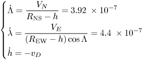
Now if 10 h is considered for the navigation time, we are going to specify the longitude and latitude of the desired endpoint by using real data from sensors.


Knowing these components, we can calculate latitude ‘Λ’ and longitude ‘λ’ at any time. The essential issue in numbering is to consider this: h = −20 m.

To solve the above integral by using experimental data, discretisation should be used:


According to calculation, the following is the tolerance of error for identifying a location's latitude and longitude of the underwater vehicle during 10 h of traveling:


5. Result and discussion
In the subsequent figures, the simulation results and error analysis for DR navigation are displayed. The values for the taken course and heading angle, as well as the amount of possible error in the taken course and the heading angle at the endpoint (during time t), can be determined based on the use of DR navigation equations (achieving the desired endpoint) and the consideration of DR navigation error equations.
Figure 8 depicts the evolution of the underwater vehicle's longitude and latitude over time. Based on DR navigation equations, which account for the distance traveled and the direction traveled, this figure presumably depicts the actual path taken by the underwater vehicle.
Changes in the longitude and latitude of an underwater vehicle over time

Figure 9 depicts the possible navigational errors in latitude and longitude over time. The X axis presumably represents time in seconds, whereas the Y axis indicates the possible error in the latitude and longitude coordinates. This graph likely illustrates the uncertainty associated with DR navigation, as errors can accumulate over time due to various factors, including flowing water error, induced frequency difference and sensor measurement error.
Latitude and longitude navigation possible errors (X: time in seconds and Y: latitude error and longitude error)

Figures 10 and 11 represent the underwater vehicle's latitude and longitude over time in the presence of system uncertainties. These numbers indicate how the underwater vehicle's actual course deviated from the calculated path due to factors such as measurement errors and environmental factors. The deviation probably corresponds to the difference between the actual and calculated paths.
Tracking the change in submarine latitude in the presence of system uncertainties

Tracking the change in underwater vehicle longitude in the presence of system uncertainties

Figure 12 displays the position navigation of an underwater vehicle while system uncertainties are available. The X axis shows longitude, while the Y axis shows latitude. The graph presumably reflects the actual position of the underwater vehicle over time, as determined by DR navigation equations, compared with the desired position.
Underwater vehicle's position navigation in the presence of system uncertainties (X: longitude amd Y: latitude)

The actual position of the underwater vehicle may deviate from the intended position in the presence of system uncertainties, such as measurement errors and environmental factors. The figure most likely illustrates the deviation between the actual and desired positions, the deviation represented by the difference between the two positions.
The accuracy and limitations of DR navigation in the presence of system uncertainties can be determined by examining these figures. The quantity of deviation between the actual position and the desired position can be used to assess the navigation system's performance and identify areas for enhancement. In addition, the deviation trend over time can reveal the effect of environmental factors and measurement errors on the navigation system's accuracy. For instance, if the deviation is growing over time, it may indicate that environmental factors have a greater impact on the navigation system as time passes. These figures provide a visual representation of the effectiveness of the underwater vehicle's navigation system in the presence of system uncertainties, and can be used to evaluate and enhance the system's accuracy.
To examine the simulation, we practically test the software with experimental data from sensor data. The position of the underwater vehicle at any time can be determined by having experimental data such as the velocity in different directions, and yaw, pitch and roll angles; and to make sure of the results of DR navigation software, they can be compared with the results of the GPS. It is pointed out that when using GPS, it is important to keep in consideration that regular GPS receivers cannot be relied upon when it is possible to send interference signals to them. Next, we model the system to achieve more precise results by incorporating the different kinds of uncertainty and possible errors mentioned in the paper. Finally, the DR navigation method results are compared with the online GPS results, taking into consideration the uncertainties, demonstrating the high level of accuracy of the method proposed in this paper.
Figure 13 displays the tracking underwater vehicle's position test performance which is done by the DR navigation system. Figures 14 and 15 display the comparisons of the underwater vehicle's position tracking by DR and GPS; they are achieved without system uncertainties and in the presence of system uncertainties, respectively. The practical results demonstrate very high tracking accuracy using the DR navigation method.
Performance test, underwater vehicle's position tracking by DR method (X: longitude and Y: latitude)

Performance test, comparison of underwater vehicle's position tracking by DR and GPS

Performance test, underwater vehicle position tracking by DR software in the presence of system uncertainties and its comparison with the tracked course by GPS

6. Conclusion
The information that was provided in the research suggests the dead reckoning (DR) navigation technique is a low-cost solution that is dependent on the dynamic equations of the system. In this study, a detailed examination of the use of DR navigation in underwater vehicles is presented, taking into consideration the possibility of sensor inaccuracy. Through the use of the DR navigation technology, the eventual location of the underwater vehicle may be estimated with a high degree of accuracy. Additionally, the findings of the system error analysis performed on the DR navigation technique using data from the actual world are presented in this study. These findings were compared with GPS data, and the comparison showed that there were only minor variations between both of them. This demonstrates that the DR navigation system properly records the precise position of the underwater vehicle. When taken as a whole, the research illustrates that the DR navigation approach is capable of achieving a high degree of accuracy, despite the fact that errors and uncertainties are present. According to the findings, the DR navigation approach seems to be an effective tool for accurately establishing the precise position of the underwater vehicle. Furthermore, it has the potential to be used in other applications that need accurate positioning.
Funding statement
The authors disclosed receipt of the following financial support for the research, authorship and/or publication of this paper: This work has been financially supported by the University of Torbat Heydarieh. The grant number is 1402/04/17-174.
Competing interests
The authors declare that they have no conflict of interest.



