INTRODUCTION
Tropical wetlands are key for biodiversity, carbon cycling, and hydrological ecosystem services (Kamukala and Crafter, Reference Kamukala and Crafter1993; Kolka et al., Reference Kolka, Murdiyarso, Kauffman and Birdsey2016), yet wetlands are rapidly changing across Africa owing to land-use management regimes, hydroclimatic variability, defaunation, and introduced taxa (Ministry of Environment and Mineral Resources, 2012; Davidson, Reference Davidson2014). Given the current rapidity and magnitude of environmental transformations driven by global climate change and intensifying anthropogenic pressures on landscapes that threaten biodiversity (Stévart et al., Reference Stévart, Dauby, Lowry, Blach-Overgaard, Droissart, Harris and Mackinder2019), the utility of long-term socioecological insights are increasingly used for contextualizing land-management dialogues and supporting public policy decisions (Marchant and Lane, Reference Marchant and Lane2014; Courtney Mustaphi et al., Reference Courtney Mustaphi, Capitani, Boles, Kariuki, Newman, Munishi, Marchant and et al2019; Said et al., Reference Said, Komakech, Munishi and Muzuka2019). High-elevation wetlands accumulate sediments over geologic timescales and are important geoarchives of past environmental conditions, especially in environments with few lake sediment deposits (Marchant et al., Reference Marchant, Richer, Capitani, Courtney Mustaphi, Prendergast, Stump and Boles2018). Wetland sediment stratigraphies from subalpine and montane wetlands provide paleoenvironmental histories across highland areas of equatorial eastern Africa (Hamilton, Reference Hamilton1982a, Reference Hamilton and Hamilton1982b; Perrott, Reference Perrott1982; Umer et al., Reference Umer, Lamb, Bonnefille, Lézine, Tiercelin, Gibert and Cazet2007; Gil-Romera et al., Reference Gil-Romera, Adolf, Benito, Bittner, Johansson, Grady and Lamb2019). For example, palustrine sediment records of vegetation change have been developed from wetlands in the Cherangani Hills (van Zinderen Bakker, Reference van Zinderen Bakker1962, Reference van Zinderen Bakker1964; Opiyo et al., Reference Opiyo, Gebregiorgis, Cheruiyot, Deocampo and Kiage2019), the Pare Mountains (Heckmann et al., Reference Heckmann, Muiruri, Boom and Marchant2014; Finch et al., Reference Finch, Marchant and Courtney Mustaphi2017), eastern Mau (Courtney Mustaphi et al., Reference Courtney Mustaphi, Githumbi, Shotter, Runcina and Marchant2016; Githumbi, Reference Githumbi2017), Mount Kenya (Olago et al., Reference Olago, Street-Perrott, Perrott, Ivanovich and Harkness1999; Rucina et al., Reference Rucina, Muiruri, Kinyanjui, McGuiness and Marchant2009), and the Eastern Arc Mountains (Finch et al., Reference Finch, Leng and Marchant2009, Reference Finch, Wooller and Marchant2014, Reference Finch, Marchant and Courtney Mustaphi2017; Finch and Marchant, Reference Finch and Marchant2011; Mumbi et al., Reference Mumbi, Marchant and Lane2014).
On Kilimanjaro, high-elevation paleoenvironmental studies have characterized late Pleistocene and Holocene vegetation and climate change derived from soils (Zech, Reference Zech2006; Zech et al., Reference Zech, Leiber, Zech, Poetsch and Hemp2011; Montade et al., Reference Montade, Schüler, Hemp, Bremond, Salamanca Duarte and Behling2018), sediments (Coetzee, Reference Coetzee1967; Schüler et al., Reference Schüler, Hemp, Zech and Behling2012; Schüler, Reference Schüler2012), and glacial ice (Thompson et al., Reference Thompson, Mosley-Thompson, Davis, Henderson, Brecher, Zagorodnov and Mashiotta2002; Gabrielli et al., Reference Gabrielli, Hardy, Kehrwald, Davis, Cozzi, Turetta and Barbante2014), and are also informed by records from nearby Lake Challa (Table 1) (Verschuren et al., Reference Verschuren, Damsté, Moernaut, Kristen, Blaauw, Fagot and Haug2009; Barker et al., Reference Barker, Hurrell, Leng, Wolff, Cocquyt, Sloane and Verschuren2011; Nelson et al., Reference Nelson, Verschuren, Urban and Hu2012; Martin-Jones et al., Reference Martin-Jones, Lane, Van Daele, Meeren, Wolff, Moorhouse and Tomlinson2020). Archaeological evidence and oral tradition summaries show a long and varied history of land use on and around Kilimanjaro (Fosbrooke and Sassoon, Reference Fosbrooke and Sassoon1965; Odner, Reference Odner1971; Mturi, Reference Mturi1986; Clack, Reference Clack2007, Reference Clack2009), though as yet, there are no published archaeological sites above 2000 m asl.
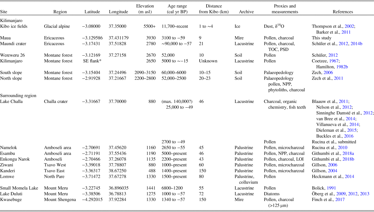
Late Quaternary paleoenvironmental studies discussed in this study on and near (<200 km) Kilimanjaro.

Notes: TOC = total organic carbon; PSD = particle size distributions; LOI = loss-on-ignition analysis; NPP = non-pollen palynomorphs; microcharcoal = pollen slide charcoal counting (Clark, Reference Clark1988); charcoal = charcoal analysis by wet sieving; ~ = approximately; * = precise location is not known to the authors (see Coetzee, Reference Coetzee1967; Hamilton, Reference Hamilton and Hamilton1982b).
Highland-lowland connectivity is an important climatic, ecological, and socioeconomic dynamic of the mountain. Rapid changes to thermal and hydroclimatic regimes have modified the cloudiness, precipitation, and glacial dynamics at high elevations on Kilimanjaro (Thompson et al., Reference Thompson, Mosley-Thompson, Davis, Henderson, Brecher, Zagorodnov and Mashiotta2002, Reference Thompson, Brecher, Mosley-Thompson, Hardy and Mark2009; Mölg and Hardy, Reference Mölg and Hardy2004; Chan et al., Reference Chan, Vuille, Hardy and Bradley2008; Park et al., Reference Park, Lee and Jung2012), and the areal extent of glacial ice has reduced over the past century (Geilinger, Reference Geilinger1936; Downie, Reference Downie1964; Hastenrath and Greischar, Reference Hastenrath and Greischar1997; Cullen et al., Reference Cullen, Mölg, Kaser, Hussein, Steffen and Hardy2006; Mote and Kaser, Reference Mote and Kaser2007). Hydroclimatic variability modifies the upper montane soils and vegetation of eastern African mountains (Coe, Reference Coe and van Oywe1967; Spence, Reference Spence and Mahaney1989; Young and Peacock, Reference Young and Peacock1992; Mizuno, Reference Mizuno1998, Reference Mizuno2005; Mizuno and Fujita, Reference Mizuno and Fujita2014), which influences downslope environments (Munger, Reference Munger1952; Mathooko and Mavuti, Reference Mathooko and Mavuti1992) and links highland-lowland ecosystems (Maro, Reference Maro1988; Chuhila, Reference Chuhila2016; de Bont, Reference de Bont2018; Kilungu et al., Reference Kilungu, Leemans, Munishi, Nicholls and Amelung2019). Montane forest hydroclimate is also influenced by anthropogenic land-use and land-cover changes at lower elevations owing to vegetation-atmosphere interactions (Fairman et al., Reference Fairman, Nair, Christopher and Mölg2011). This highland-lowland connectivity creates cascading effects on ecosystem functions and services and amplifies human-environment feedback with socioeconomic and political ramifications (Tagseth, Reference Tagseth2008; Mahonge, Reference Mahonge2010; Sébastien, Reference Sébastien2010; Komakech and de Bont, Reference Komakech and de Bont2018; Kilungu et al., Reference Kilungu, Leemans, Munishi, Nicholls and Amelung2019).
Here we present a 3000-year sediment record of vegetation change established from a wetland located at the ericaceous-alpine vegetation ecotone on the south-facing slope of Kilimanjaro. Centennial-scale sampling resolution for proxy vegetation and fire change throughout the late Holocene has not been explored in detail in previous paleoenvironmental studies on the mountain. Pollen, phytolith, and charcoal analyses from the Maua sediment record contributes to this knowledge gap, and we present a discussion of the results contextualized with available data on the climatic and ecological drivers of vegetation change on Kilimanjaro, including the known history of land-use and land-cover change summarized from published archaeological reports, historical texts, and oral traditions. The results focus on a temporal knowledge gap of vegetation change in a fire-prone ecosystem that is susceptible to future rapid ecological change due to climatic variability and anthropogenic land-use pressures.
Study region
Kilimanjaro (5895 m asl) is a composite of several dormant stratovolcanoes and satellite craters with an eruptive history beginning during the Early Quaternary (Schlüter, Reference Schlüter1997; Nonnotte et al., Reference Nonnotte, Guillou, Le Gall, Benoit, Cotten and Scaillet2008). It consists of volcanic and pyroclastic rocks flanked by an apron of mixed epiclastic sedimentary rock with airfall tuffs and reworked pyroclasts (Pickford, Reference Pickford, Frostick, Renaut, Reid and Tiercelin1986; Schlüter, Reference Schlüter1997). At alpine elevations, interbedding of glacial and volcanic extrusive deposits present a long history of variable glacial conditions (Downie, Reference Downie1964; Osmaston, Reference Osmaston and Mahaney1989), and the ice records around Kibo suggest that ice cover has remained since at least the early Holocene (Thompson et al., Reference Thompson, Mosley-Thompson, Davis, Henderson, Brecher, Zagorodnov and Mashiotta2002). The mountain is an important source of orographic precipitation that supplies surficial and groundwater flows to several surrounding watersheds, including the Pangani and Galana Rivers that drain into the Indian Ocean as well as the endorheic drainage systems of Lakes Challa, Jipe, and Amboseli (Meijerink and van Wijngaarden, Reference Meijerink, van Wijngaarden, Gilbert, Mathieu and Fournier1997). Moisture is primarily derived from the Indian Ocean by an easterly circulation that varies with seasonal monsoon fronts and interactions with teleconnected climatic modes such as the Indian Ocean Dipole (Rodhe and Virji, Reference Rodhe and Virji1976; Saji et al., Reference Saji, Goswami, Vinayachandran and Yamagata1999; Nicholson, Reference Nicholson2000; Marchant et al., Reference Marchant, Mumbi, Behera and Yamagata2007). Precipitation is modally concentrated during the rainy seasons of March–June and November–January (Coutts, Reference Coutts1969; Hemp, Reference Hemp2001; Oettli and Camberlin, Reference Oettli and Camberlin2005). The mountain experiences strong diurnal patterns: warm daytime temperatures transition to cold nights, with minimum temperatures below freezing and the possibility of night-time snowfall. Similar to other mountains of eastern Africa, Kilimanjaro experiences complex ecohydrological feedback between vegetation and the atmosphere that vary by plant communities, elevation, aspect, and topography (Hemp, Reference Hemp2001, Reference Hemp2009; Fairman et al., Reference Fairman, Nair, Christopher and Mölg2011; Cuní-Sanchez et al., Reference Cuní-Sanchez, Omeny, Pfeifer, Olaka, Mamo, Marchant and Burgess2019; Los et al., Reference Los, Street-Perrott, Loader, Froyd, Cuní-Sanchez and Marchant2019).
Biodiversity is high and vegetation distribution patterns are complex owing to intermittent habitat connectivity between Kilimanjaro, Mount Meru, and the older and highly endemic Eastern Arc Mountains (Burgess et al., Reference Burgess, Fjeldså and Botterweg1998, Reference Burgess, Butynski, Cordeiro, Doggart, Fjeldså, Howell and Kilahama2007; Platts et al., Reference Platts, Burgess, Gereau, Lovett, Marshall, McClean and Pellikka2011; Jump et al., Reference Jump, Carr, Ahrends and Marchant2014; Hemp and Hemp, Reference Hemp and Hemp2018; Burger et al., Reference Burger, Anderson, Balk and Fristoe2019). The alpine zone (>3900 m asl) of the southern flank has a mean annual temperature ranging from 0.7 to 4.2°C and a mean precipitation ranging from 500 to 700 mm year-1 (Schüler et al., Reference Schüler, Hemp and Behling2014a; Schüler and Hemp, Reference Schüler and Hemp2016), where short alpine plants have patchy coverage (Hedberg, Reference Hedberg1951; Hemp and Beck, Reference Hemp and Beck2001). The subalpine zone (2800–3900 m asl) experiences frost and at its upper limits is dominated by ericaceous vegetation that is continuous-to-patchy Ericaceae and Poaceae heathland with short, woody shrubs and microphyllous species with distributins influenced by fires (Hemp and Beck, Reference Hemp and Beck2001; Hemp, Reference Hemp2005a, Reference Hemp, Spehn, Liberman and Körner2005b, Reference Hemp2009; Detsch et al., Reference Detsch, Otte, Appelhans, Hemp and Nauss2016). Precipitation reaches a maximum of 1800 mm year−1 at ~2200 m asl (Wood, Reference Wood1965a; Røhr and Killingtveit, Reference Røhr and Killingtveit2003; Schüler and Hemp, Reference Schüler and Hemp2016), supporting montane forests from 1600 to 2800 m asl with a complex continuum of trees and epiphytic species distributions (Hemp, Reference Hemp2006a, Reference Hemp2006b, Reference Hemp, Bruijnzeel, Scatena and Hamilton2011) that are crosscut with distinct riverine gallery forests (Hemp, Reference Hemp2006b). Submontane forests persist at <1600 m asl, where the vegetation is often modified by cultivation (between ~1000 and 1800 m asl), with settlements and coffee-banana plantations, agroforestry, and forest gardens (Maro, Reference Maro1988; Hemp, Reference Hemp2008; Mathew et al., Reference Mathew, Majule, Sinclair and Marchant2016a, Reference Mathew, Majule, Sinclair and Marchant2016b).
Fire is key among the ecological disturbances, interacting with and modifying high-elevation plant communities (Hemp, Reference Hemp2005a, Reference Hemp2009; Finch and Marchant, Reference Finch and Marchant2011; Detsch et al., Reference Detsch, Otte, Appelhans, Hemp and Nauss2016). Fires are both naturally occurring and anthropogenically ignited, with a long history as a land-management tool (Archibald et al., Reference Archibald, Staver and Levin2012; Kamau and Medley, Reference Kamau and Medley2014). Fire return intervals, an important variable for maintaining fire-adapted ecosystems, are shorter in grassy and ericaceous ecosystems (<decadal to decadal frequencies) (Hempson et al., Reference Hempson, Parr, Archibald, Anderson, Courtney Mustaphi, Dobson and Donaldson2018) and much longer in moist montane forests that are dominated by woody fuels (subcentennial to centennial frequencies) and have different ecohydrological interactions. Yet, there are no studies quantifying fire return intervals in montane forests of eastern Africa. Fire regimes modify vegetation ecotones on mountains at both lower and upper elevations (Wood, Reference Wood1965b; Hemp and Beck, Reference Hemp and Beck2001; Hemp, Reference Hemp2005a; Heckmann et al., Reference Heckmann, Muiruri, Boom and Marchant2014), and fire regime variability is associated with climate change (Wood, Reference Wood1965b; Hemp, Reference Hemp2005a, Reference Hemp2009) and anthropogenic activities in forests on the adjacent Pare Mountains (Heckmann, Reference Heckmann2014; Finch et al., Reference Finch, Marchant and Courtney Mustaphi2017).
Study site
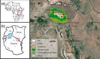
The Maua wetland (3°7′46.51″S, 37°25′52.24″E; 3930 m asl; Fig. 1) is a sloping depression, ~75 m wide × 250 m long (0.35 ha), in the basaltic rock of the saddle of Kilimanjaro (Fig. 2). Maua, a Kiswahili word translating as “flower,” is a toponym also associated with a stream catchment on the southeastern flank of the mountain. The wetland is nestled between lateral moraine deposits (Downie, Reference Downie1964; Osmaston, Reference Osmaston and Mahaney1989; Rosqvist, Reference Rosqvist1990; Shanahan and Zreda, Reference Shanahan and Zreda2000) and has an outflow that drains southward. Hydric edaphic conditions are maintained by rain, snow, and occult precipitation into the depression.
(color online) Study site location in (A) Africa and (B) equatorial eastern Africa. (C) Map of Kilimanjaro area showing the Maua study site (black square), glacial ice fields, soil profile, palustrine and lacustrine sediment paleoenvironmental study sites (black circles; see Table 1). Basemap: Google Earth, 2019. http://earth.google.com/web/

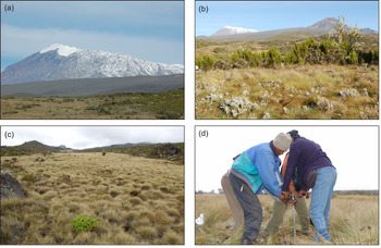
(color online) (a) The high-elevation alpine zone. (b) The surrounding landscape of the Maua wetland showing the alpine-ericaceous ecotone. (c) A view of the study site showing tussock vegetation. (d) Coring with a Russian corer to collect the palustrine sediments of the wetland. Photographs by Rob Marchant.

The alpine vegetation zone (3900–4600 m asl) around the wetland is characterized by shrubby Erica heathlands and Helichrysum cushion vegetation (Fig. 2a and b; Schüler and Hemp, Reference Schüler and Hemp2016) with thin soils and patchy barren areas of glacial deposits. Vegetation in the Maua wetland is dominated by Poaceae, with Cyperaceae, Asteraceae, pteridophytes, and localized clusters of Dendrosenecio that reach 1–2 m in height (Fig. 2c). The continuous, low-lying vegetation grows on the hummocks and hollows that define the wetland microtopography (Fig. 2c and d). Current land uses near the wetland include ecotourism, as there are nearby mountaineering trails and camps, and occasional honey collecting at high elevation by subsistence foragers in the Mount Kilimanjaro National Park.
METHODS
Fieldwork
On January 29, 2009, the Maua wetland sediment catena was probed using 1-m-long connectable rods to locate the central basin with the deepest sediment deposit. A 165 cm deep sediment stratigraphy was collected from the deepest accumulation using a hand-pushed Russian peat corer with a 50-cm-long × 5-cm-diameter hemicylindrical chamber (Belokopytkov and Beresnevich, Reference Belokopytkov and Beresnevich1955; Jowsey, Reference Jowsey1966) from parallel core holes with ≥10 cm overlap for each drive. The sediment cores were wrapped in plastic and aluminium foil for transportation from the site and were later stored in refrigerators at 4°C. Pollen and phytolith analyses on the cores were performed at the National Museums of Kenya, Nairobi; and charcoal analysis was performed at the University of York, United Kingdom.
Geochronology and age-depth model
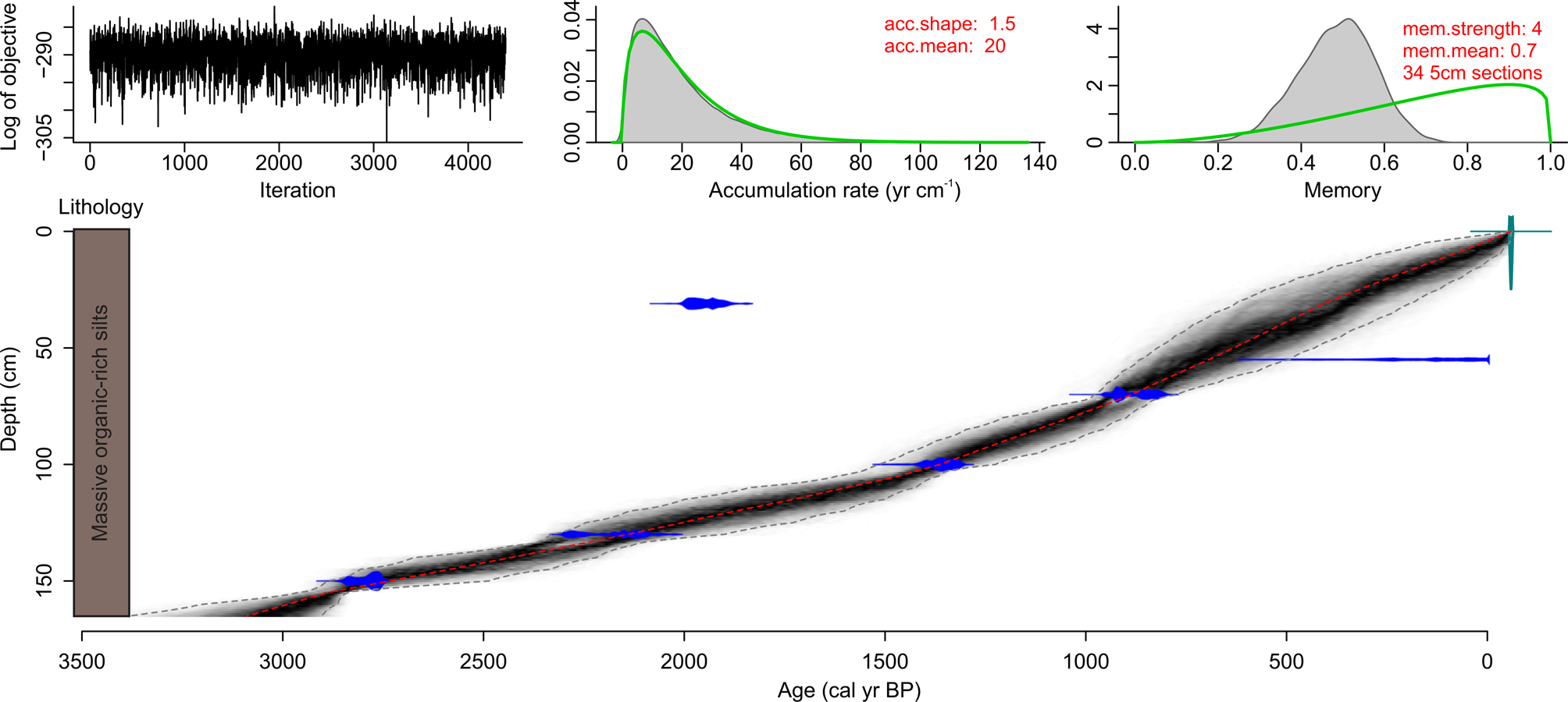
Accelerator mass spectrometry (AMS) radiocarbon dating of six bulk sediment subsamples provided a geochronology for the Maua sediment core. Samples were submitted to Waikato Radiocarbon Laboratory, Waikato, New Zealand, and DirectAMS, Bothell, WA, USA, and were alkali-acid-alkali pretreated, combusted to CO2, and reduced to graphite on a catalyst prior to AMS. Measured 14C ages were corrected for isotopic fractionation with δ13C values. These reported dates were not rounded (Stuiver and Polach, Reference Stuiver and Polach1977) and used to develop a Bacon version 2.2 age-depth model in the R statistical programming language version 3.4.0 (Blaauw and Christen, Reference Blaauw and Christen2011a, Reference Blaauw and Christen2011b; R Development Core Team, 2017). Radiocarbon ages (14C yr BP) were calibrated using a Southern Hemisphere calibration curve (SHCal13; Hogg et al., Reference Hogg, Hua, Blackwell, Buck, Guilderson, Heaton and Niu2013) and expressed as calibrated years before present (cal yr BP). To provide age estimates for all subsampling depths in the core, ages were interpolated using the weighted mean within a 95% confidence envelope of the densities of ~8 million t-walk iterations using the Markov chain Monte Carlo algorithm through the probability densities of the calibrated radiocarbon dates (Blaauw and Christen, Reference Blaauw and Christen2011a).
Pollen analysis
Thirty-three wet sediment samples of 1 cm3 were taken for pollen analysis from 1-cm-thick levels spaced at 5 cm intervals down the core, from 5 to 165 cm. To remove carbonate, organic matter, and siliceous materials from the subsamples, pollen preparations followed a sequential chemical digestion using NaOH, HCl, HF, and acetolysis (Erdtman, Reference Erdtman1960; Fægri and Iversen, Reference Fægri and Iversen1989). Between the acid and base digestion steps the samples were rinsed with deionized water and decanted, or rinsed with glacial acetic acid for acetolysis, and then rinsed with ethanol (95%) to prepare the pollen residues for microscopy. The samples were not sieved during processing and were not stained with a staining medium. The pollen residue was suspended in glycerol gel for storage, and a small volume was mounted on microscope slides with coverslips for microscopy. Pollen grains were enumerated under an Olympus CX21FS1 microscope at 400× magnification to a minimum count of 430 grains. Two exceptions occurred: (1) a single sample at 5 cm depth was counted to 342 grains and was retained in the numerical analyses, and (2) a sample at 45 cm depth was excluded from the pollen diagram and other analyses as it anomalously contained 125 grains. Pollen identifications were aided by using the pollen microscope slide reference collection at the Palynology and Palaeobotany Section at the National Museums of Kenya in Nairobi, the African Pollen Database (Lézine, Reference Lézine2001; Hély et al., Reference Hély, Bremond, Alleaume, Smith, Sykes and Guiot2006; Vincens et al., Reference Vincens, Lézine, Buchet, Lewden and Le Thomas2007), and published reference keys (Assemien et al., Reference Assemien, Bonnefille, Cambon-Bou, Caratini, Cerceau, Dang and Fredoux1974; Bonnefille and Riolet, Reference Bonnefille and Riollet1980; Retief and van Wyk, Reference Retief and van Wyk2001; van Geel et al., Reference van Geel, Gelorini, Lyaruu, Aptroot, Rucina, Marchant, Damsté and Verschuren2011). For challenging identifications, particularly cf. Ehretia (Boraginaceae), fresh pollen reference material was collected from herbarium samples at the National Museums of Kenya and compared directly with the pollen residues extracted from the Maua wetland sediments. Relative abundances were calculated from the total pollen sum. Spirogyra algal remains and spores of the coprophilous fungus Sporormiella were also enumerated during pollen counts and used as presence data (van Geel et al., Reference van Geel, Gelorini, Lyaruu, Aptroot, Rucina, Marchant, Damsté and Verschuren2011).
Pollen groupings
Pollen taxa assignments to ecological groups were done by harmonizing several published classifications of montane pollen records in the region (Rucina et al., Reference Rucina, Muiruri, Downton and Marchant2010; Rucina, Reference Rucina2011; Schüler et al., Reference Schüler, Hemp, Zech and Behling2012, Reference Schüler, Hemp and Behling2014b; Schüler, Reference Schüler2012; Schüler and Hemp, Reference Schüler and Hemp2016; Finch et al., Reference Finch, Marchant and Courtney Mustaphi2017).
Macroscopic charcoal analysis
A total of 153 samples of 1 cm3 were extracted at nearly complete, contiguous 1 cm intervals from 0 to 165 cm stratigraphic depth for macroscopic charcoal analysis. Each sample was soaked for >24 hours in a labeled glass beaker of sodium hexametaphosphate solution of varying concentrations to disaggregate the sediments and deflocculate ionic clays from organic detritus (Bamber, Reference Bamber1982). Samples were then wet sieved through a 125 μm mesh, and the retained content was examined under a Zeiss Stemi 2000-C stereomicroscope between 10 and 50× magnifications. Individual charcoal pieces were manipulated with a metal probe, identified with visual and haptic diagnostics (Hawthorne et al., Reference Hawthorne, Courtney Mustaphi, Aleman, Blarquez, Colombaroli, Daniau and Marlon2017), and tallied (Whitlock and Larsen, Reference Whitlock, Larsen, Smol, Birks and Last2001; Scott, Reference Scott2010; Marlon et al., Reference Marlon, Kelly, Daniau, Vannière, Power, Bartlein and Higuera2016). Subsequently, charcoal concentrations (pieces cm−3 wet sediment) were converted to charcoal accumulation rates (CHARs, pieces cm−2 yr−1) using the age-depth model estimates (Whitlock and Larsen, Reference Whitlock, Larsen, Smol, Birks and Last2001; Conedera et al., Reference Conedera, Tinner, Neff, Meurer, Dickens and Krebs2009).
Phytolith analysis
A total of 46 samples of 1 cm3 of wet sediment were taken from 1-cm-thick levels at sampling intervals varying between 1 and 5 cm down the core, from 1 to 165 cm. Phytolith extraction followed a heavy liquid floatation procedure (Albert, Reference Albert1999) with a few modifications (Mercader et al., Reference Mercader, Bennett, Esselmont, Simpson and Walde2009). The procedure involved digesting ~3 g of sediment with a 10 mL solution of equal volume hydrochloric and nitric acid (3 molar HCl and 3 molar HNO3) to remove carbonates and organic components, respectively. The acidified samples were placed in a hot water bath until bubbling ceased, then washed with distilled water, vortexed, and centrifuged for five minutes at 3000 rpm. A 5 mL solution of sodium polytungstate (Na6[H2W12O40]) with a relative density of 2.4 was added to the decanted residues, and samples were vortexed, sonicated, and centrifuged for five minutes at 3000 rpm (Munsterman and Kerstholt, Reference Munsterman and Kerstholt1996). The supernatants holding the phytoliths were transferred to 10 mL vials. An aliquot of ~1 mg was placed on a 25.4 × 76.2 mm microscope slide and mixed with two to three drops of Entellen New® Rapid Mounting Medium before overlaying a 22 × 40 mm rectangular coverslip. Phytolith counts and identifications were done at 400× magnification using an Olympus BX52 optical light microscope. A target of at least 200 phytoliths was used for morphological classification. In samples with very low phytolith counts, at least 50 phytoliths were counted to obtain as much information as possible, following Albert and Weiner (Reference Albert, Weiner, Meunier and Colin2001), except for two samples that yielded less than 50 phytoliths.
Phytolith morphological classifications and identifications were based on various sources, including the International Code of Phytolith Nomenclature 2.0 (International Committee for Phytolith Taxonomy, 2019), published studies (Twiss et al., Reference Twiss, Suess and Smith1969; Tieszen et al., Reference Tieszen, Senyimba, Imbamba and Troughton1979; Piperno, Reference Piperno1988, Reference Piperno, Smol, Birks and Last2002, Reference Piperno2006; Rapp and Mulholland, Reference Rapp and Mulholland1992; Twiss, Reference Twiss, Rapp and Mulholland1992; Albert, Reference Albert1999; Fredlund and Tieszen, Reference Fredlund and Tieszen1997; Madella et al., Reference Madella, Alexandre and Ball2005; Barboni and Bremond, Reference Barboni and Bremond2009; Mercader et al., Reference Mercader, Bennett, Esselmont, Simpson and Walde2009, Reference Mercader, Astudillo, Barkworth, Bennett, Esselmont, Kinyanjui and Grossman2010; Neumann et al., Reference Neumann, Fahmy, Lespez, Balloche and Huysecom2009; Rossouw, Reference Rossouw2009), and a reference collection created and housed at the Palynology and Paleobotany Section, National Museums of Kenya, Nairobi (Kinyanjui, Reference Kinyanjui2013, Reference Kinyanjui2018).
Phytolith assemblage groupings
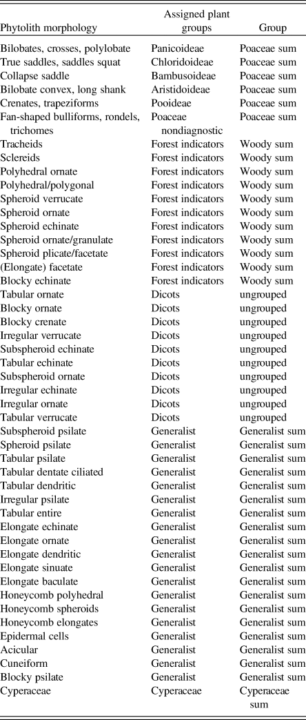
Based on taxonomic associations, phytoliths were grouped into four categories:
1. Poaceae: both diagnostic and nondiagnostic grass short cell phytoliths (GSCPs) such as saddles, bilobates, crosses, rondels, trapezoids, polylobates, fan-shaped bulliforms, and infilled trichomes.
2. Woody plants: spheroid variants (ornate, echinate, verrucate), tracheids, and sclereids.
3. Cyperaceae: achenes, papillae, and cylindroid crenate morphotypes.
4. Generalists: all other discernible morphotypes that have yet to be diagnostically assigned to known taxonomic affiliations in the literature.
To understand grassy-vegetation-cover dynamics, we further categorized morphotypes into their respective taxonomic affiliations as follows: bilobates, crosses and polylobates (Panicoideae), true and squat saddles (Chloridoideae), bilobates with long shanks (Aristidoideae), and collapsed saddles (Bambusoideae).
Data analyses
A stratigraphically constrained cluster analysis (CONISS; Grimm, Reference Grimm1987) was applied to the pollen assemblages, and a broken stick model (Bennett, Reference Bennett1996) was used to test zones for significance using the rioja package version 0.9-15 (Juggins, Reference Juggins2017) with scripts in R version 3.4.0 (R Development Core Team, 2017) and plotted with C2 software (Juggins, Reference Juggins2007). To estimate turnover, a rate of change analysis of the dissimilarities between each pollen assemblage was done through functions from the PaleoMAS package version 2.0-1 (Urrego et al., Reference Urrego, Bush, Silman, Correa-Metrio, Ledru, Mayle, Valencia, Vimieux, Sylvestre and Khodri2009; Correa-Metrio et al., Reference Correa-Metrio, Urrego, Cabrera and Bush2011).
We analyzed phytolith data with two commonly used approaches: general and indices (Neumann et al., Reference Neumann, Fahmy, Lespez, Balloche and Huysecom2009). In the general approach, all the identified morphotypes were plotted as abundance diagrams using C2 (Juggins, Reference Juggins2007) to view the data and CONISS zonation. The indices approach used well-defined taxa-diagnostic morphotypes to calculate indices that reflect grassland composition and vegetation structures known to correlate with climate variables such as temperature and moisture gradients (Bremond et al., Reference Bremond, Alexandre, Peyron and Guiot2005, Reference Bremond, Alexandre, Wooller, Hély, Williamson, Schäfer and Majule2008). Morphotypes used for this study included true and squat saddles (Chloridoideae); bilobates, crosses, polylobates (Panicoideae); and spheroid ornates (woody dicots) (Bremond et al., Reference Bremond, Alexandre, Peyron and Guiot2005, Reference Bremond, Alexandre, Wooller, Hély, Williamson, Schäfer and Majule2008). The indices approaches first required the use of principal component analyses (PCA) on the square-root transformed relative abundances to determine the significance of various morphotypes with regards to identifying vegetation structure types. The following three indices were explored to trace changes in canopy openness/closedness and climatic associations: (1) the aridity (Iph) index, which uses the ratio of Chloridoideae to Panicoideae diagnostic morphotypes (both C4 grasses) to infer the preponderance of short or long C4 grasses along an aridity-humidity gradient (Bremond et al., Reference Bremond, Alexandre, Peyron and Guiot2005); (2) the tree density (D:P) index, which uses the ratio of the sum of spheroid ornate (cf. spheroid granulate) morphotypes diagnostic of woody dicotyledons versus the diagnostic GSCP (Panicoideae and Chloridoideae) morphotypes to estimate canopy openness (Alexandre et al., Reference Alexandre, Meunier, Lezine, Vincens and Schwartz1997; Bremond et al., Reference Bremond, Alexandre, Wooller, Hély, Williamson, Schäfer and Majule2008); and (3) the climate index (Ic), which estimates the proportion of C3 grasses using the ratio of diagnostic morphotypes produced by Pooideae and Bambusoideae subfamilies versus C4 Panicoideae and Chloridoideae (Bremond et al., Reference Bremond, Alexandre, Wooller, Hély, Williamson, Schäfer and Majule2008). The selection of the GSCPs was guided by Neumann et al. (Reference Neumann, Fahmy, Müller-Scheeßel and Schmidt2017): bilobates, polylobates, and crosses were selected to represent Panicoideae; squat and true saddles were selected to represent Chloridoideae; bilobates with a very long shank were representative of Aristidoideae; while trapeziform and rectangular or oblong rondels were grouped as Pooideae C3 grasses.
RESULTS
Stratigraphy and age-depth model
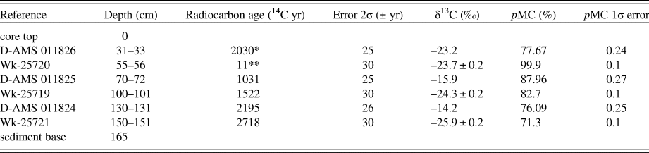
The sediments of the Maua wetland were dense, organic-rich deposits from 165 cm to the surface, with a few rootlets visible in the top 50 cm. Radiocarbon date determinations are presented in Table 2, and the age-depth model is presented in Figure 3. The uppermost radiocarbon date at 31–33 cm depth (D-AMS011826) was objectively discarded from the age-depth model, and the near modern radiocarbon date at 55–56 cm (Wk-25720) was assigned a skewed student's t distribution to account for the long distribution tails of young calibrated radiocarbon ages (Christen and Pérez, Reference Christen and Pérez2010), creating a more linear and parsimonious age-depth model. Alternative exploratory models with a more normal distribution for this specific date at 55–56 cm forced a resulting age-depth model with a rapid recent accumulation of sediment, though the core stratigraphy had no visible evidence of such rapid accumulation, as would be seen with a transition to peat, for example. Arguably, the uppermost radiocarbon date at 31–33 cm depth does suggest movement of older carbon into the wetland, though there is no conspicuous visual evidence that this was the result of a rapid mass movement of sediments along the relatively gentle slopes proximal to the wetland.
Uncalibrated date determinations from six bulk sediment AMS radiocarbon dates from the Maua wetland sediment core collected on January 29, 2009 (−59 cal yr BP).

Notes: The radiocarbon analytical errors are shown as reported from the laboratory and are not rounded (Stuiver and Polach, Reference Stuiver and Polach1977). The measured modern carbon fraction is presented as pMC. * = date objectively excluded from the Bacon age-depth model; ** = nearly modern radiocarbon age was treated with long tapering tails on the calibrated age distributions (Blaauw and Christen, Reference Blaauw and Christen2011b).
Bacon R script age-depth model (red dotted line), random walks (grayscale), and 95% CI (dotted gray lines) of six SHCAL13 radiocarbon dates (distributions in blue) and parameter settings (red text at top right) for the Maua wetland sediment stratigraphy (Table 1; Blaauw and Christen, Reference Blaauw and Christen2011a; R Development Core Team, 2017). Ages reported as cal yr BP. (For interpretation of the references to color in this figure legend, the reader is referred to the web version of this article.)

Pollen and charcoal record
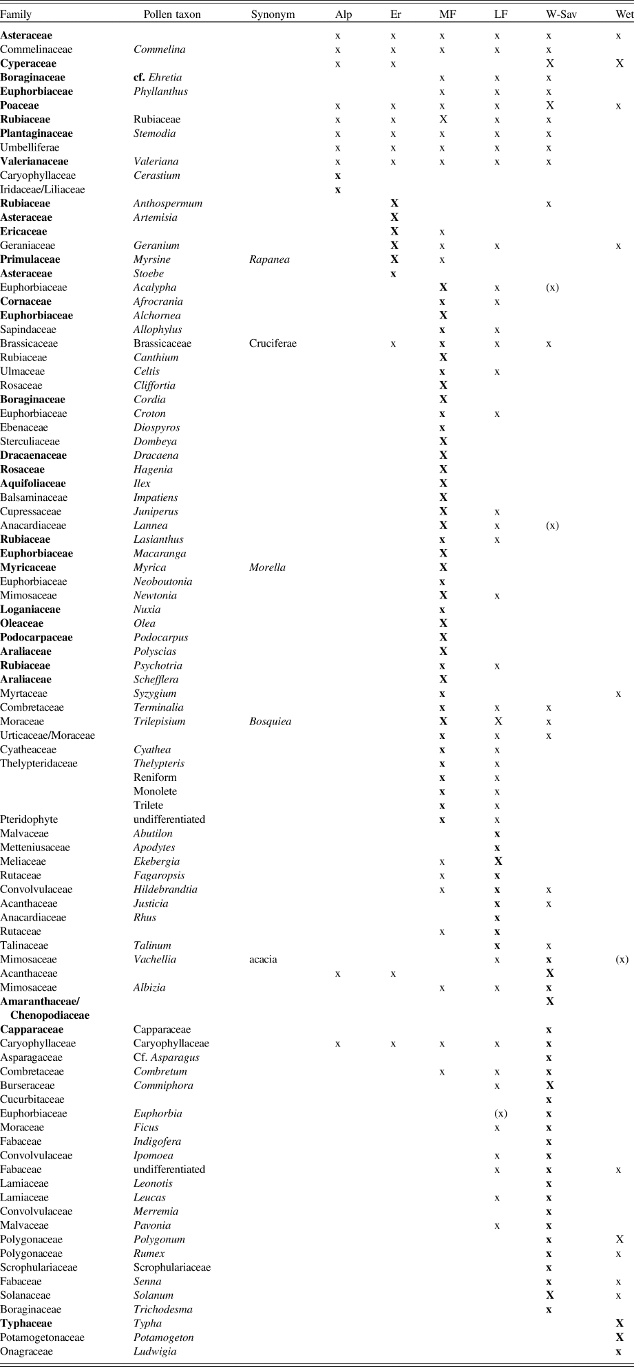
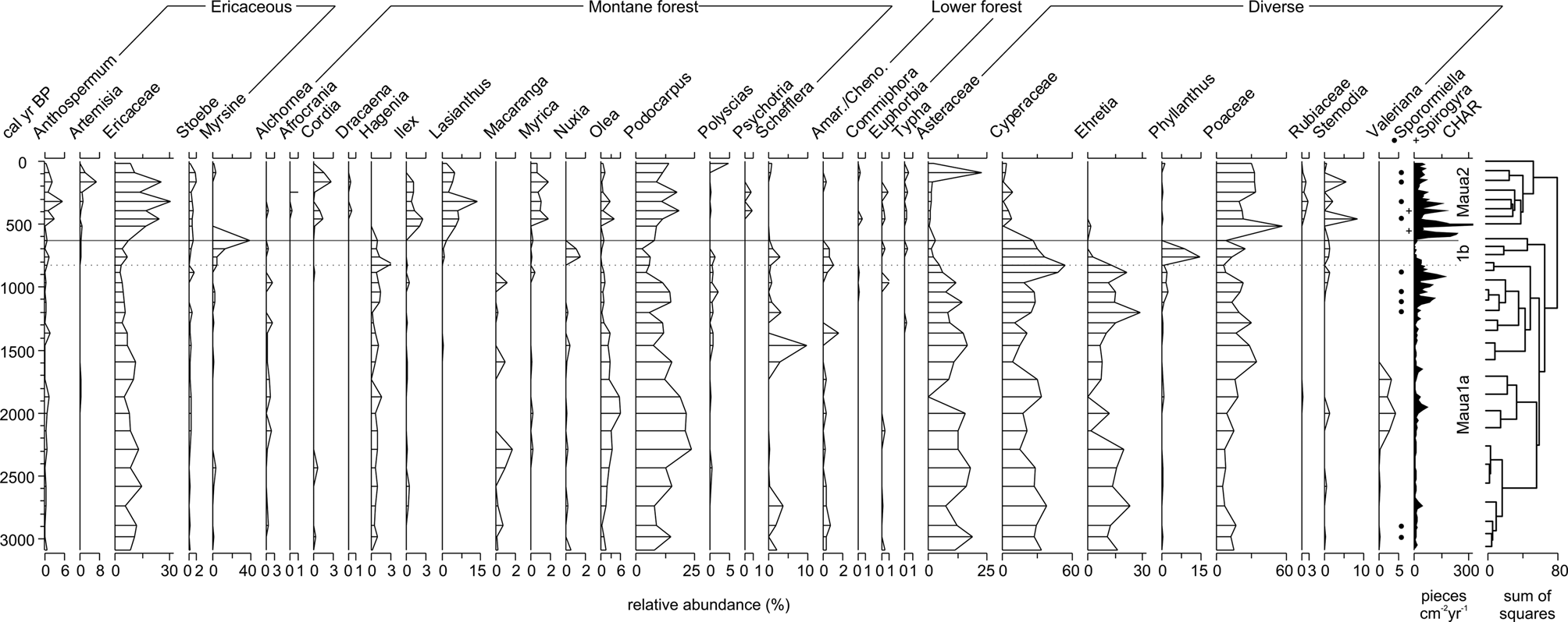
A total of 32 samples were retained for plotting the pollen diagram and for numerical analysis. A total of 94 pollen types were identified (Table 3), including two aquatic plant taxa (Typha and Potamogeton). Aquatic taxa were infrequent (<1.5% total pollen relative abundance) and were not used to create a separate aquatic pollen sum. The pollen taxa groups are presented in Figure 4 and Table 3. Spirogyra, a filamentous and often epiphytic green algae common to lentic freshwaters (Ross, Reference Ross1953; Denny et al., Reference Denny, Bowker and Bailey1978), was observed only at 30–31 cm (393 cal yr BP). Spores of Sporormiella, a coprophilous fungus, were observed in 10 subsamples, reaching their highest counts at 85–86 and 80–81 cm (1122–1040 cal yr BP). Pollen analysis at 5 cm intervals averaged 100 years between samples with a range of 75 to 155 years, permitting interpretations of variability in vegetation cover on centennial and millennial scales. Charcoal analysis at 1 cm sampling intervals averaged 19 years between samples with a range of 12–31 years, allowing for analyses at a multidecadal resolution. Twelve charcoal samples (7.3%) were missing values because of limited sediment material and were linearly interpolated using the nearest neighbors for graphing (at 0–1, 4–5, 10–11, 15–16, 18–19, 27–28, 33–34, 34–35, 52–53, 57–58, 60–61, and 164–165 cm).
Pollen taxa assignments to biomes for vegetation interpretation through harmonizing published pollen records in the area (Rucina et al., Reference Rucina, Muiruri, Downton and Marchant2010; Rucina, Reference Rucina2011; Schüler Reference Schüler2012; Schüler et al., Reference Schüler, Hemp, Zech and Behling2012, Reference Schüler, Hemp and Behling2014a, Reference Schüler, Hemp and Behling2014b; Schüler and Hemp, Reference Schüler and Hemp2016; Finch et al., Reference Finch, Marchant and Courtney Mustaphi2017).

Notes: Plant taxonomic groupings are listed as used in this study. Alp = alpine; Er = ericaceous; MF = montane forest; LF = lower forest; W-Sav = woody savannah; Wet = wetlands; X = predominantly occurs; x = present; (x) = occasionally present. Taxa in bold font are presented in the pollen diagram (Fig. 3).
Selected pollen taxa relative abundances and CONISS-based zonation showing significant changes in the assemblage composition (solid horizontal line) and insignificant changes (dashed horizontal line). CHARs shown at far right.

The pollen assemblage consisted of three zones: Maua1a, Maua1b, and Maua2. CONISS identified two statistically distinct pollen assemblage zones in the core: Maua1, from 3000 to 600 cal yr BP, and Maua2, from 600 cal yr BP to the present. A statistically insignificant subzone was identified from 800 to 600 cal yr BP (Maua1b; Fig. 4), with relatively high variability that is evident on visual examination of the data (Fig. 4).
Zone Maua1a (3000–800 cal yr BP) was predominated by Cyperaceae (20–60%), Asteraceae (<25%), cf. Ehretia (Boraginaceae, <30%), and Poaceae (10–35%). Montane forest taxa are also present, including high and consistent abundances of Podocarpus (8–25%), Olea (2–6%), and Hagenia (2%). Charcoal influx is relatively low and appears correlated with Cyperaceae and cf. Ehretia, though values increase at 1200–800 cal yr BP.
The statistically insignificant subzone Maua1b (800–600 cal yr BP) was characterized by conspicuously low charcoal influx. Podocarpus, Ericaceae, Asteraceae, and cf. Ehretia decreased to the lowest values of the record, though both Cyperaceae and Poaceae decreased only slightly. In contrast, abundances of Myrsine, Hagenia, Nuxia, Amaranthaceae/Chenopodiaceae, Phyllanthus, and Stemodia increased during Maua1b (Fig. 4).
Zone Maua2 (600 to −59 cal yr BP) was dominated by ericaceous taxa (Ericaceae, Anthospermum, Artemisia, and Stoebe) that increased in abundance from Maua1. Compared to Maua1, Maua2 features higher peaks and higher mean accumulation rates of charcoal. Montane forest taxa (Cordia, Ilex, Lasianthus, and Myrica) are also more consistently present, and there are relatively high abundances of Podocarpus. Hagenia, Macaranga, Nuxia, and cf. Ehretia are absent from Maua2. Poaceae, Rubiaceae, and Stemodia increase to their highest abundances, while Asteraceae and Cyperaceae are lower than during Maua1a.
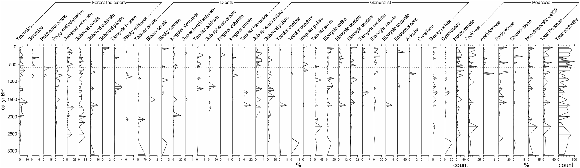
Phytolith record
A total count range of 29–621 phytoliths were counted per sample, with an average of 272 ± 160 (1σ standard deviation). Indeterminable phytolith counts per sample ranged from 0 to 55, with a mean of 17. The phytolith morphology groups are presented in Figure 5 and Table 4. Samples with total counts below 100 (n = 9 of 45 samples) were removed from statistical analyses. CONISS zonation of the phytolith assemblage did not identify statistically significant zonal boundaries but did delimit a single statistically insignificant boundary at 550 cal yr BP. The calculation of phytolith-based indices (Bremond et al., Reference Bremond, Alexandre, Wooller, Hély, Williamson, Schäfer and Majule2008) was hampered by several 0-count values, and thus division by zero created high overall noise in the phytolith assemblage record. This suggests that either the phytolith assemblage at Maua has a high amount of noise or the assemblage was very different from those derived from previous investigations in montane environments in eastern Africa. Both options are conceivable given the source plant types present, the paucity of existing phytolith studies examining high-elevation vegetation, and also the possibility of syn- and postdepositional taphonomic processes.

Phytolith assemblage with CONISS zonation. No significant zone boundaries were identified, and a single insignificant boundary is shown (dotted horizontal line), which occurs slightly after the Maua2 pollen zone (see Fig. 4).

The phytolith record was dominated by woody and generalist morphotypes. Woody morphotypes included spheroid ornate (cf. spheroid granulate) (up to 80%), spheroid plicate (cf. spheroid rugose) (<25%), and spheroid verrucate (<25%). Generalist morphotypes, which are present across various taxonomic groups including grasses, included spheroid psilate (<50%), parallelepiped psilate (<50%), and cylindroid psilate (<30%). The phytolith assemblage is characterized by high levels of variation in both the Poacaeae and the woody taxa present throughout the record. In terms of relative abundance, morphotypes classified as Poaceae (GSCPs) contributed an average 20% to the total phytoliths in each sample. Woody types have a consistently high occurrence until ~800 cal yr BP and subsequent decrease to the present. Poaceae types were consistently higher only over the past 300 years (Fig. 5).
Review of late Holocene land-use histories on Kilimanjaro
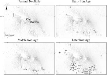
The literature review collated and categorized published archaeological research from Kilimanjaro and is informed by regional patterns of livelihood change throughout the late Holocene. Current prominent land uses on Kilimanjaro include commercial crop cultivation, forestry, urban settlements, conservation, and ecotourism. Archaeological and historical evidence indicate that land use on and around Kilimanjaro since the mid Holocene featured hunting and gathering (continuously throughout this time), pastoralism (~4000 cal yr BP), and agriculture (~2000 cal yr BP). It is important to note that the mountain has not yet been archaeologically surveyed using systematic methods. Despite Kilimanjaro being an UNESCO World Heritage Site, remarkably little archaeological work has been done to explore the full history of late Holocene human occupation. Despite the lack of published material evidence across the landscape, highland-lowland connections are remembered by current inhabitants as being of both great antiquity and cultural significance. For example, oral traditions refer to the earliest people on the mountain as Wakonigo, whose presence in montane forests is marked by old shrines, broken pots, and sacred Chagga plants such as masala (Dracaena) (Stahl, Reference Stahl1964, p. 53; Clack, Reference Clack2009). Some of the oldest known clan histories from Kilimanjaro speak of how the ancestors first settled high-elevation areas such as the Shira plateau (3600–3800 m asl) before descending the mountain (Stahl, Reference Stahl1964, pp. 58–59). The known published archaeological sites are notably absent at high elevations (none above 2000 m asl) and the northeastern slopes of the mountain (Fig. 6), but this spatial pattern must be interpreted with caution given the uneven degree of archaeological sampling effort across the landscape (Marchant et al., Reference Marchant, Richer, Capitani, Courtney Mustaphi, Prendergast, Stump and Boles2018).
Topographic maps of Kilimanjaro showing published archaeological finds across the mountain. The sites are organized into four material culture groupings. A list of sites, radiocarbon dates, and references are presented in Supplementary Table 1.

It is not certain that people avoided occupying high-elevation areas of Kilimanjaro in the past, and thus the prospect remains that anthropogenic modifications to vegetation and fire regimes may have occurred around the Maua wetland. There are physiological challenges posed by traveling to altitudes as high as Maua. For example, humans accustomed to living at sea level experience hypoxia when they ascend to elevations in excess of 2500 m asl (Beall, Reference Beall2014). Furthermore, temperature and rainfall conditions at Maua would make the cultivation of African staple crops around the site unrealistic. Livestock also suffer when residing at moderate to high elevations, and cattle in particular are susceptible to altitude-induced pulmonary hypertension (Pauling et al., Reference Pauling, Speidel, Thomas, Holt and Enns2018). Livestock that have developed adaptations are, however, able to thrive at impressive elevations and have been known to live at 4000 m asl (Claxton and Ortiz, Reference Claxton and Ortiz1996). Questions remain as to how common the physiological capacity for life at extremely high elevations is across eastern African human and livestock populations. Pastoral Neolithic sites on the Mau escarpment located above 2500 m asl, such as the Remnant site (2800 m asl; Bower et al., Reference Bower, Nelson, Waibel and Wandibba1977), indicate that early herders were capable of occupying areas of considerable elevation, a skill no doubt encouraged by their habitation adjacent to the Rift Valley, a region with intense topographic relief. Still, Maua is much higher than these known comparable sites on neighboring highlands, and the availability of resources, including altitudinal oxygen, is appreciably different. Livestock herding is thus likely to have been a highly marginal practice above 4000 m asl on Kilimanjaro. The available evidence does not, however, allow us to discount the possibility of humans engaging in other activities at Maua, including ceremonial or hunting and gathering practices. The recent discovery of obsidian outcrops in the Bale Mountains of Ethiopia at 4200 m asl, which were being used as early as the Middle Stone Age by people living at 3469 m asl, is especially intriguing (Ossendorf et al., Reference Ossendorf, Groos, Bromm, Tekelemariam, Glaser, Lesur and Schmidt2019) and highlights the need for further archaeological exploration of past utilizations of African highlands, including Kilimanjaro. Ethnoarchaeological investigations of current and recent historical high-elevation land uses on Kilimanjaro, and the ecological legacies of such activities, are also needed.
Regarding interpreting the paleoenvironmental records at Maua, it is necessary to state that the degree to which pollen and charcoal in the Maua sediment records are derived from lower-elevation gradients, where there is more concrete evidence of human land-use and land-cover change, is also relatively uncertain. The upslope transport of pollen can overrepresent arboreal taxa at high-elevation sites (Markgraf, Reference Markgraf1980; Solomon and Silkworth, Reference Solomon and Silkworth1986; Urrego et al., Reference Urrego, Silman, Correa-Metrio and Bush2011). Modern pollen rain studies on the southern slope of Kilimanjaro, along an elevational gradient between 1900 and 3200 m asl (from the submontane forest to upper montane forests), indicate that pollen and spore deposition are representative of the surrounding vegetation, though their dispersal is strongly influenced by regional wind patterns; even in closed canopy sites, high- and low-pollen-producing, nonlocal (>100 m distance) taxa are represented (Schüler et al., Reference Schüler, Hemp and Behling2014b). As Table 3 indicates, the Maua sediments do contain pollen that has been transported from lower elevations and are thus assumed to be capturing, to an extent, signatures of anthropogenically driven vegetation transformation occurring downslope.
Age determinations for archaeological site occupations are more often inferred from associated ceramic ware assemblages because few of the known sites have been radiocarbon dated (Supplementary Table 1). Early Iron Age sites are designated as any recorded presence of Kwale ware ceramics, a pottery tradition roughly dating from the first century to the mid first millennium (Soper, Reference Soper1967; Helm, Reference Helm2000). Middle Iron Age sites mark the occurrence of Maore ware, dating to around the later first millennium and early second millennium (Odner, Reference Odner1971; Soper, Reference Soper1976; Walz, Reference Walz2010). Later Iron Age sites indicate the presence of either Odner's (Reference Odner1971) Kilimanjaro Group C, D, or E; Lanet ware; or Soper's (Reference Soper1967) Group D ware from Usambara. All are thought to have been in use in the second millennium (Posnansky, Reference Posnansky1967; Helm, Reference Helm2000, p. 68). Considering the paucity of archaeological investigation, there is certainly scope to reevaluate and further refine ceramic typologies for Kilimanjaro. To support our interpretation of human-environmental interactions, we plot the archaeological finds that exist in four broad time intervals; these extend from the early food-producing Pastoral Neolithic through the Late Iron Age (Fig. 6).
DISCUSSION
Vegetation assemblage changes at Maua
Maua1a (3000–800 cal yr BP)
During the early Maua record, ericaceous and montane forest pollen types decreased slightly, while Poaceae and Cyperaceae increased (Figs. 4 and 7). Charcoal also increased slightly throughout Maua1a and positively correlated with variations in Cyperaceae pollen. This correlation suggests Cyperaceae made much of the fuel source for the locally created charcoal and that there were increased abundances in Cyperaceae in the wetland during Maua1a. Peak pollen abundances of Podocarpus in the Maua record occur from 2300 to 2000 cal yr BP, concomitant with peak abundances at Lake Rutundu, Mount Kenya (3140 m asl; Coetzee, Reference Coetzee1967; Hamilton, Reference Hamilton1982a), and with increasing relative abundances from 2600 to 1600 cal yr BP at Oblong Tarn, Mount Kenya (Courtney Mustaphi et al., Reference Courtney Mustaphi, Gajewski, Marchant and Rosqvist2017). A previously studied wetland sediment pollen record from Kilimanjaro (2650 m asl; Coetzee, Reference Coetzee1967) shows an increase in Podocarpus from ~4000 to 1800 cal yr BP, although the sampling resolution is rather low, and the relative change is due to large variations in Ilex in that record. It is challenging to examine variability in anemophilous pollen taxa in mountainous areas (Birks and Birks, Reference Birks, Birks, Birks and Birks1980; Markgraf, Reference Markgraf1980; Solomon and Silkworth, Reference Solomon and Silkworth1986), but these coincidental variations in Podocarpus could be related to the expansion of montane Podocarpus-dominated forests driven by hydroclimatic changes or changing fire disturbance regimes.
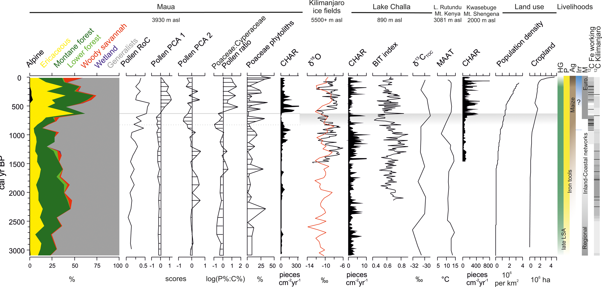
Cumulative relative abundances for pollen groups, rate of change (turnover, RoC; Urrego et al., Reference Urrego, Bush, Silman, Correa-Metrio, Ledru, Mayle, Valencia, Vimieux, Sylvestre and Khodri2009; Correa-Metrio et al., Reference Correa-Metrio, Urrego, Cabrera and Bush2011), and principal components analysis axes 1 and 2 are shown with the pollen-based CONISS zonation (horizontal solid and dashed lines, see Fig. 4). The ratio of the relative pollen abundances Poaceae:Cyperaceae (log transformed for visualization) and the total relative abundance Poaceae phytolith morphotypes from Maua are shown (Fig. 5). Additional palaeoenvironmental datasets are plotted for compairson: including an oxygen isotope record from the Kilimanjaro south ice field (black curve); and three proxy records from Lake Challa: a smoothed mixed composite record (red line) (Thompson et al., Reference Thompson, Mosley-Thompson, Davis, Henderson, Brecher, Zagorodnov and Mashiotta2002); macroscopic charcoal (>180 μm; Nelson et al., Reference Nelson, Verschuren, Urban and Hu2012); a branched versus isoprenoid tetraether (BIT) index of monsoon-promoted sediment transport into the lake (low BIT = drier conditions; Buckles et al., Reference Buckles, Verschuren, Weijers, Cocquyt, Blaauw and Sinninghe Damsté2016); and a stable carbon isotope record derived from sediment total organic carbon (Moernaut et al., Reference Moernaut, Verschuren, Charlet, Kristen, Fagot and De Batist2010; Blaauw et al., Reference Blaauw, van Geel, Kristen, Plessen, Lyaruu, Engstrom and van der Plicht2011; Sinninghe Damsté et al., Reference Sinninghe Damsté, Verschuren, Ossebaar, Blokker, van Houten, van der Meer and Plessen2011). A mid-elevation temperature reconstruction derived from the sediments of Lake Rutundu, Mount Kenya (Loomis et al., Reference Loomis, Russell, Verschuren, Morrill, De Cort, Damsté and Olago2017) and a charcoal record from Kwasebuge, North Pare Mountains (Finch et al., Reference Finch, Marchant and Courtney Mustaphi2017). Land-use modeled outputs for what is now the United Republic of Tanzania: human population density estimates (Kaplan and Krumhardt, Reference Kaplan and Krumhardt2011; Kaplan et al., Reference Kaplan, Krumhardt, Ellis, Ruddiman, Lemmen and Klein Goldewijk2011) and total cropland area (Klein Goldwijck et al., Reference Klein Goldewijk, Beusen and Janssen2010) are also shown to compare general patterns in land-use changes. Livelihood strategies on and around Kilimanjaro have also been qualitatively summarized alongside the published radiocarbon dates from archaeological sites (Odner, Reference Odner1971; Mturi, Reference Mturi1986; Tagseth, Reference Tagseth2008; Stump and Tagseth, Reference Stump, Tagseth and Clack2009; Chuhila, Reference Chuhila2016; de Bont, Reference de Bont2018; see Supplementary Table 1). HG = hunter-gatherer; P = pastoralism (and agropastoral); Ag = agricultural; Irr = furrow irrigation for agriculture on the lower slopes of Kilimanjaro; the blue dotted line shows potential regional onset of terraced agriculture (Sutton, Reference Sutton, Widgren and Sutton2004; Stump, Reference Stump2006); M = mercantile (Euro. = increased European connections and colonialism). Calibrated radiocarbon age ranges using OxCal 4.2 (n = 14 dates, 95.4% confidence intervals shown, SHCal13; Bronk Ramsey, Reference Bronk Ramsey2009; Hogg et al., Reference Hogg, Hua, Blackwell, Buck, Guilderson, Heaton and Niu2013) and converted to cal yr BP are associated with iron production and iron working in the Mwanga region (<1400 m asl), North Pare (Iles et al., Reference Iles, Stump, Heckmann, Lang and Lane2018; Iles, Reference Iles2020). (For interpretation of the references to color in this figure legend, the reader is referred to the web version of this article.)

The wetland was probably ice free by the Holocene transition (Shanahan and Zreda, Reference Shanahan and Zreda2000; Mark and Osmaston, Reference Mark and Osmaston2008), and glacial ice on Kilimanjaro was greatly reduced and varied slightly during the late Holocene before experiencing significant reductions over the past century (Hastenrath and Greischar, Reference Hastenrath and Greischar1997; Thompson et al., Reference Thompson, Mosley-Thompson, Davis, Henderson, Brecher, Zagorodnov and Mashiotta2002). The wetland was dominated by Cyperaceae-Poaceae vegetation throughout the Maua1a zone. Increased abundances of charcoal and Cyperaceae appear to be correlated with wetter intervals (less negative δ18O values) associated with the composite of isotope records of the Kilimanjaro ice fields (Fig. 7; Thompson et al., Reference Thompson, Mosley-Thompson, Davis, Henderson, Brecher, Zagorodnov and Mashiotta2002); this potentially supports the argument that local wetland biomass and burning was influenced by high-elevation hydroclimate during this interval. The charcoal was most likely locally created in the wetland and its watershed, although it was not assessed if charcoal is transported uphill by convection from lower elevation fires (Pisaric, Reference Pisaric2002; Tinner et al., Reference Tinner, Hofstetter, Zeugin, Conedera, Wohlgemuth, Zimmermann and Zweifel2006; Adolf et al., Reference Adolf, Wunderle, Colombaroli, Weber, Gobet, Heiri and van Leeuwen2018), highlighting a topic for further research on tropical mountains (Vachula and Richter, Reference Vachula and Richter2018).
The pollen record from Small Momela Lake at 1440 m asl on Mount Meru shows centennial-scale variability in the relative abundances of Poaceae and Cyperaceae from 3000 to 1200 cal yr BP (Bolick, Reference Bolick1991). The increased charcoal accumulation at Maua from 110 to 800 cal yr BP coincided with increased charcoal accumulation from 1300 to 900 cal yr BP at Lake Challa (Nelson et al., Reference Nelson, Verschuren, Urban and Hu2012), large increases in Poaceae from 1400 to 800 cal yr BP at the Namelok wetland (Rucina et al., Reference Rucina, Muiruri, Downton and Marchant2010), and increased charcoal at the Enkongu wetland, Amboseli (Githumbi et al., Reference Githumbi, Kariuki, Shoemaker, Courtney Mustaphi, Chuhila, Richer and Lane2018b). All these sites are located in the lowlands surrounding Kilimanjaro (Fig. 7), and it is difficult to disentangle regional climate and anthropogenic drivers of environmental change to explain these variations. The varying relative importance of fire regime drivers at each site may explain some of the spatiotemporal variability (Gillson, Reference Gillson2004). Ericaceous pollen is relatively low during this initial burning interval (1200–800 cal yr BP), while Hagenia, Podocarpus, Cyperaceae, and cf. Ehretia abundances are relatively high (Fig. 4).
Phytolith data between 3000 and 2500 cal yr BP represent local input consisting largely of Cyperaceae morphotypes, indicating the wetland was relatively moist during this interval. Between 2500 and 800 cal yr BP, the phytolith assemblage reflects both local and watershed-area inputs derived from woody dicots, particularly the spheroid morphotypes (Fig. 5). There is a notable presence of the Pooideae morphotypes, mainly derived from the tussock grass types common on hummocky alpine periglacial ecosystems. This suggests that the water level in the wetland was generally very low, and the absence of aquatic vegetation pollen types supports the interpretation that the wetland was covered by terrestrial vegetation.
People practicing hunting and gathering were almost certainly living on Kilimanjaro throughout the Holocene and may have even preferred higher-elevation areas as the savanna-montane forest ecotonal zone retreated at the termination of the African Humid Period (Ambrose and Sikes, Reference Ambrose and Sikes1991). The oldest archaeological remains suggestive of livestock on Kilimanjaro were deposited ~4000 cal yr BP on the western side of the mountain, just below 2000 m asl, in the lower montane forest zone (Mturi, Reference Mturi1986). Material remains affiliated with the Savanna Pastoral Neolithic archaeological group, and thus specialized pastoralism, are also present here and date to between 3000 and 1500 cal yr BP. Faunal remains from these sites are predominantly of cattle and sheep or goat, though wild animals are also present, suggesting a mixed livelihood of pastoral activity and subsistence hunting. Indeed, regional archaeological records indicate that hunting and gathering modes of production would have overlapped and persisted with pastoralism and agriculture over the last three millennia, rather than having been displaced through time (Lane, Reference Lane2004). The possibility of intensive “wild” resource management by hunter-gatherer and livestock-herding populations on Kilimanjaro during and prior to the last three millennia also merits further consideration, as there is clear evidence for the careful management of morphologically undomesticated plant species in other regions of sub-Saharan Africa (Lane and Shoemaker, Reference Lane, Shoemaker and Spear2017). Yet despite Kilimanjaro being one of eastern Africa's “islands of intensive agriculture” (Widgren, Reference Widgren, Widgren and Sutton2004, p.1), the early history of human-vegetation relationships remains almost entirely unknown. Farming in the wider region is typically thought to have become established after 2000 cal yr BP, however, accompanied by Bantu language speakers, agropastoralism, and iron working (see Crowther et al., Reference Crowther, Prendergast, Fuller and Boivin2018 for a review). This date is probably best considered a terminus ante quem for the origins of farming in the area because finger millet (Eleusine coracana) was very likely cultivated in eastern Africa before the so-called Bantu expansion (Fuller, Reference Fuller, Neumann and Butler2003; Fuller and Boivin, Reference Fuller and Boivin2009). Some have suggested that Asian domesticates, such as taro (Colocasia esculenta), chicken (Gallus gallus domesticus), and banana (Musa spp.), were also being farmed in eastern Africa prior to 2000 cal yr BP (Chami, Reference Chami, Chami, Pwiti and Radimilahy2001; Mbida et al., Reference Mbida, Van Neer, Doutrelepont and Vrydaghs2000, Reference Mbida, Doutrelepont, Vrydaghs, Swennen, Swennen, Beeckman and De Langhe2001, Reference Mbida, Doutrelepont, Vrydaghs and Beeckman2004, Reference Mbida, De Langhe, Vrydaghs, Doutrelepont, Swennen, Van Neer, de Maret, Zeder and Bradley2006; Lejju et al., Reference Lejju, Taylor and Robertshaw2005, Reference Lejju, Robertshaw and Taylor2006; De Langhe, Reference De Langhe, Denham, Iriate and Vrydaghs2007), and Kilimanjaro may have been an early locus for banana cultivation, though the evidence is inconclusive (Sinclair, Reference Sinclair, Starkey, Starkey and Wilkinson2007; Neumann and Hildebrand, Reference Neumann and Hildebrand2009; Shipton et al., Reference Shipton, Crowther, Prendergast, Kourampas, Horton, Douka and Schwenninger2016). Coastal archaeological records could suggest that the widespread adoption of Asian domesticates by eastern African farmers did not occur until the last millennium (Walshaw, Reference Walshaw2015; Crowther et al., Reference Crowther, Prendergast, Fuller and Boivin2018). Iron smelting may have also occurred on Kilimanjaro over the last two thousand years, though archaeologists have yet to document iron-working remains, suggesting it was extremely limited in scope compared to operations underway in the Pare Mountains from the second half of the first millennium (Iles et al., Reference Iles, Stump, Heckmann, Lang and Lane2018; Iles, Reference Iles2020). It is possible that people used high-elevation areas of Kilimanjaro during the Maua1a zone for herding, hunting and gathering, transportation routes, or ceremonial activities, though direct evidence is lacking. Certainly, the surrounding lower-elevation areas were being modified by human activities, including pastoralism, hunting and gathering, and agriculture by 2000 cal yr BP (probably increasingly so).
Maua1b subzone (800–600 cal yr BP)
The pollen assemblage subzone is dynamic and represents an assemblage transition between Maua1a and Maua2, with distinctively low charcoal, high Cyperaceae abundances, increasing turnover rates in the pollen assemblage (Fig. 7), highly variable phytolith assemblages, and negative values in the pollen PCA axis 2 scores (Fig. 7); the samples from this zone also cluster together on the PCA biplot (Supplementary Fig. 1). Low CHARs could be due to several factors: The local hydroclimatic regime could have become too wet and reduced flammability; decreased ignitions (anthropogenic, lightning, spontaneous) may have limited fires; fuel connectivity could have also been interrupted as vegetation became more sparse or increasingly dissected by, for example, animal trails; and lastly, productivity changes could have affected total aboveground biomass (fuel availability). Aboveground biomass varies owing to vegetation productivity and herbivory regimes; the latter has been linked to consumption of the potential fuels for carrying fires and fragmenting the grass canopy (Archibald et al., Reference Archibald, Bond, Stock and Fairbanks2005; Bond and Keeley, Reference Bond and Keeley2005; Hempson et al., Reference Hempson, Archibald, Bond, Ellis, Grant, Kruger and Kruger2015; Donaldson et al., Reference Donaldson, Archibald, Govender, Pollard, Luhdo and Parr2018). There are very few studies of high-elevation herbivory on Afroalpine vegetation by domestic or wild animals (Mulkey et al., Reference Mulkey, Smith and Young1984; for subalpine effects, see Wood, Reference Wood1965b; Kikoti et al., Reference Kikoti, Mligo and Kilemo2015) or information that explains reduced fire ignitions; thus, it remains difficult to explore the equifinality of the observed low CHARs. During this subzone, the wetland transitioned from a Cyperaceae-Poaceae–dominated habitat to a more Cyperaceae-dominated one (see high abundances in Fig. 4) with lower fuel flammability and connectivity and lower grazing desirability. The Maua1b subzone also has concomitant changes in both the montane forest and the ericaceous taxa assemblages (Fig. 4; Supplementary Fig. 1). Several montane forest taxa, such as Nuxia, Hagenia, and Schefflera, increase and then decrease during the subzone, and a conspicuous decrease in Podocarpus abundances is evident (Fig. 4). During Maua1b, Kilimanjaro ice field δ18O values are markedly more negative, as is the Lake Challa branched versus isoprenoid tetraether (BIT) index and reconstructed mean annual air temperatures at Lake Rutundu (Fig. 7; Sinninghe Damsté et al., Reference Sinninghe Damsté, Verschuren, Ossebaar, Blokker, van Houten, van der Meer and Plessen2011; Loomis et al., Reference Loomis, Russell, Verschuren, Morrill, De Cort, Damsté and Olago2017), suggesting that—at least at middle and lower elevations—the region was cooler and drier.
Maua2 (600 to –59 cal yr BP)
This zone is significantly different from Maua1 and has more positive scores on the PCA axis 1, suggesting further rapid changes in the mountain flora in and around the wetland following the Maua1b transition (Fig. 7). Pollen assemblage turnover remains highest during this most recent interval, and the uppermost samples are characterized by very different pollen assemblages (Fig. 7). The phytolith assemblage shows a trend of decreasing forest indicators and woody dicots. Cyperaceae morphotypes also decrease, though Poaceae morphotypes increase; Chloridoideae C4 short grasses in particular become more prominent. Overall, the phytolith evidence suggests either drier conditions or clearing of woody plants, possibly both (Fig. 5). From 500 cal yr BP to the present, a general decrease in or total absence of forest indicators, dicots, and Cyperaceae morphotypes is evident, while Chloridoideae C4 grasses are notably present during Maua2. The charcoal record suggests a very different fire regime of increased burning since the onset of Maua2, indicating more fire-adapted taxa (Poaceae and Ericaceae) with consistently higher Poaceae phytolith morphotypes (GSCPs) and higher local biomass (Figs. 4 and 5). Increased charcoal during Maua2 could be related to increased vegetation biomass available to burn (Courtney Mustaphi and Pisaric, Reference Courtney Mustaphi and Pisaric2014) in response to increased moisture availability in the wetland. The site may have thus transitioned from a Cyperaceae to a Poaceae tussock-dominated wetland, as it remains at present. The data do not make it possible to examine if the wetland itself was ever covered by ericaceous vegetation, as is the case for some high-elevation mires (Salt, Reference Salt1954) or if it remained consistently dominated by Poaceae throughout Maua2. While CHARs decreased during Maua2 to the present, counts are nonetheless predominantly much higher in comparison to previous intervals. On Kilimanjaro at present, herbaceous biomass increases from the mid-montane forest to alpine elevations; this is linked to changing moisture availability (Ensslin et al., Reference Ensslin, Rutten, Pommer, Zimmermann, Hemp and Fischer2015), potentially suggesting a connected between surface moisture, productivity, and fire.
The epiphytic filamentous green algae Spirogyra was observed in very low abundance (three individual remains with a count of 650 pollen) at 393 cal yr BP, which suggests the potential for puddling in the wetland among the vegetation (Ross, Reference Ross1953; Denny et al., Reference Denny, Bowker and Bailey1978). Spirogyra dominated the phytoplankton community in the Lower Kitandara Lake (4020 m asl) and in the Ruwenzori Mountains (Richardson, Reference Richardson1964); it was also found in late Pleistocene peaty sediments at a swamp in the Udzungwa Mountains (Mumbi et al., Reference Mumbi, Marchant, Hooghiemstra and Wooller2008). Spirogyra is frequently present in aquatic ecosystems with high thermal and radiation variability (Gelorini et al., Reference Gelorini, Verbeken, van Geel, Cocquyt and Verschuren2011), diurnal conditions that prevail in the Maua wetland. If occasional puddling in the wetland occurred during the past few hundred years, it suggests that multiannual alternation between wet and dry conditions would be an important characteristic of the climate-vegetation-fire relationship during Maua2, a situation markedly different than during Maua1.
The pollen and charcoal records indicate that local vegetation during this zone becomes predominantly ericaceous with high abundances of Erica, Artemisia, Anthospermum, and Stoebe. Taxa in both the Ericaceae and Poaceae families likely benefited from increased fire, as has been described in other Holocene records from high-elevation Erica heathland sites in eastern Africa (Gil-Romera et al., Reference Gil-Romera, Adolf, Benito, Bittner, Johansson, Grady and Lamb2019). The associations between charcoal, ericaceous taxa, and Poaceae at Maua suggest a more fire-adapted vegetation community at the wetland during a time of regionally drier high-elevation climate (Thompson et al., Reference Thompson, Mosley-Thompson, Davis, Henderson, Brecher, Zagorodnov and Mashiotta2002), decreasing reconstructed daytime relative humidity (Hepp et al., Reference Hepp, Zech, Rozanski, Tuthorn, Glaser, Greule and Keppler2017), and higher ericaceous pollen abundances at the Maundi crater (Schüler et al., Reference Schüler, Hemp, Zech and Behling2012). This suggests a more nuanced study of the complex local ecohydrology is needed to explain these patterns to further understand hydroclimate, vegetation and fire, and grazing interactions.
The lacustrine sediment record from Small Momela Lake does not cover this time interval in detail, but the low elevation sites of Lake Challa (Fig. 7; Sinninghe Damsté et al., Reference Sinninghe Damsté, Verschuren, Ossebaar, Blokker, van Houten, van der Meer and Plessen2011) and Lake Duluti show evidence of change during Maua2. At Lake Duluti, significant changes to diatom assemblages occur in the past 700 years, both in the relative abundances of planktonic and periphytic taxa and with respect to an overall decrease in periphytic diatoms toward the present, suggesting more open water (Öberg et al., Reference Öberg, Norström, Ryner, Holmgren, Westerberg, Risberg and Eddudóttir2013). The stable carbon-isotopic composition of fossil plant leaf waxes from sediments in Lake Challa increase and remain at their highest values (averaging −30‰) from the past 3000 years (average −31‰; Fig. 7; Sinninghe Damsté et al., Reference Sinninghe Damsté, Verschuren, Ossebaar, Blokker, van Houten, van der Meer and Plessen2011), suggesting relatively wet conditions at least at low elevations. Lake Challa is groundwater fed, and it has been noted that there is a negative relationship during the late Holocene between δ18O values in Lake Challa diatoms (Barker et al., Reference Barker, Hurrell, Leng, Wolff, Cocquyt, Sloane and Verschuren2011). Similar to Maua, an onset of increased fire activity in the recent centuries occurred at Kwasebuge in the North Pare Mountains, though it has been more directly attributed to changing human activities in the forests using pollen from tree taxa that benefit from forest-edge disturbances (Finch et al. (Reference Finch, Marchant and Courtney Mustaphi2017). Evidence of vegetation and erosion changes from colluvium and palustrine deposits in the Pare Mountains suggests increasing land-use intensities, increased erosion, and changing vegetation cover (Heckman, Reference Heckmann2014). It has been hypothesized that this intensification of soil erosion over the last five centuries occurred owing to wood use for increased iron smelting and smithing (Schmidt, Reference Schmidt, Hamilton and Bensted-Smith1989; Håkansson, Reference Håkansson, Cliggett and Pool2007) or to intensification in agricultural production to meet the demands of an increasingly international landscape connectivity as trade caravans became larger and more frequent, particularly in response to global market demand for ivory (Biginagwa, Reference Biginagwa2012; Iles et al., Reference Iles, Stump, Heckmann, Lang and Lane2018). Furthermore, large changes to CHARs are evident in several palustrine records from areas surrounding Kilimanjaro and show high spatial variation in fire histories (Gillson, Reference Gillson2004; Githumbi et al., Reference Githumbi, Courtney Mustaphi, Yun, Muiruri, Rucina and Marchant2018a, Reference Githumbi, Kariuki, Shoemaker, Courtney Mustaphi, Chuhila, Richer and Lane2018b). CHARs increase after 500 yr BP at the Kimana and Enkongu wetlands in Amboseli, although the geochronological uncertainty is high at Kimana (Githumbi et al., Reference Githumbi, Courtney Mustaphi, Yun, Muiruri, Rucina and Marchant2018a), and the Namelok wetland record shows increased charcoal content after 300 yr BP-present (Rucina et al., Reference Rucina, Muiruri, Downton and Marchant2010). Charcoal accumulations are lower from 400 to 500 yr BP to the present at both Kanderi and Tsavo (Gillson, Reference Gillson2004) and at Esambu, Amboseli (Githumbi et al., Reference Githumbi, Kariuki, Shoemaker, Courtney Mustaphi, Chuhila, Richer and Lane2018b). The differing signals in charcoal accumulation highlight local-scale fuel and fire responses, the spatial heterogeneity of savannah fire regimes, the understudied complexities of fire regimes at savannah-wetland edges (Kirby et al., Reference Kirby, Lewis and Sexson1988; Kirkman, Reference Kirkman1995; Casanova and Brock, Reference Casanova and Brock2000; Cassidy, Reference Cassidy2007; Nielsen et al., Reference Nielsen, Podnar, Watts and Wilson2013; Saintilan and Rogers, Reference Saintilan and Rogers2015), and more broadly the role of human activities in and around wetlands (Seki et al., Reference Seki, Shirima, Courtney Mustaphi, Marchant and Munishi2018).
National-scale models estimate that populations and agricultural land use were expanding during this time (Fig. 7), tentatively supporting the hypothesis that anthropogenic drivers of land-cover change intensified (Klein Goldwijck et al., Reference Klein Goldewijk, Beusen and Janssen2010; Kaplan and Krumhardt, Reference Kaplan and Krumhardt2011; Kaplan et al., Reference Kaplan, Krumhardt, Ellis, Ruddiman, Lemmen and Klein Goldewijk2011). Suggestions that intensifications in land use were escalating during the last five centuries should be interpreted with caution, however, as evidence for anthropogenically induced environmental change—in the form of written records, detailed oral histories, and more conspicuous archaeological remains—becomes increasingly accessible toward the present, potentially leading to underestimations of the magnitude and intensity of earlier land use. Nonetheless, several lines of evidence suggest a diversity of human-environment modifications during this time (Fig. 6): remains of terraced irrigation infrastructure at highlands in the region (up to 1200 m asl; Sutton, Reference Sutton, Widgren and Sutton2004; Stump, Reference Stump2006; Lang and Stump, Reference Lang and Stump2017); remains of caves, dugouts, and bolt-holes used to shelter people, cattle, and valuables during conflicts (Clack, Reference Clack2009; Silayo, Reference Silayo2016); oral histories for mfongo (stream-fed) irrigation systems on the slopes of Kilimanjaro (Tagseth, Reference Tagseth2010); cultivation of crops introduced from the Americas (including maize and tobacco; Miracle, Reference Miracle1965; Cherniwchan and Moreno-Cruz, Reference Cherniwchan and Moreno-Cruz2019); Chagga forest gardens (Fernandes et al., Reference Fernandes, Oktingati and Maghembe1985); historical records of elephant hunting, especially using game-pits dug in the upper cultivation zone, at ~2000 m asl (Meyer Reference Meyer1891, p. 126); records of ivory-trade involvement (Coutu et al., Reference Coutu, Lee-Thorp, Collins and Lane2016); historical records of apiary operations in the heathland vegetation zone at, ~2900–3550 m asl (Meyer, Reference Meyer1891, p. 133); limited-scale iron smelting at Uru, Mamba, and Marangu (Wimmelbücker, Reference Wimmelbücker2002, p.62); and oral histories of other mountain forest uses (Stump and Tagseth, Reference Stump, Tagseth and Clack2009). On the lower southeastern slopes of Kilimanjaro, mfongo irrigation systems, together with water-storage ponds (Kimaro et al., Reference Kimaro, Scharsich, Kolb, Huwe and Bogner2019) have likely contributed significantly to modifying local ecologies. Mfongo networks are recognized to be central to the cultural heritage of the Chagga people (Tagseth, Reference Tagseth2010, p. 16). Oral traditions, historical references, and linguistic evidence allow for us to conclude that irrigation features on Kilimanjaro were being built by at least the seventeenth century (Stump and Tagseth, Reference Stump, Tagseth and Clack2009), though irrigation systems had emerged in the wider region from as early as the fourteenth century (Fig. 7; Sutton, Reference Sutton, Widgren and Sutton2004; Lang and Stump, Reference Lang and Stump2017; Kabora, Reference Kabora2018; Thornton-Barnett, Reference Thornton-Barnett2018; Kabora et al., Reference Kabora, Stump and Wainwright2020). The emergence and intensification of irrigation agriculture is linked to societal, ecological, and climatic factors (Boserup, Reference Boserup1965; Börjeson, Reference Börjeson2007; Håkansson, Reference Håkansson, Cliggett and Pool2007; Davies, Reference Davies2015). Furrow expansion and defensive constructions during the nineteenth century (Kusimba et al., Reference Kusimba, Kusimba and Wright2005; Clack, Reference Clack2007, Reference Clack2009) do, however, seem to coincide with a time of political centralization, conflict, slave raiding (Wimmelbücker, Reference Wimmelbücker2002), and intensified long-distance caravan trade (Stump and Tagseth, Reference Stump, Tagseth and Clack2009, p. 111). Kilimanjaro was a major node along multiple caravan trade routes, and high-elevation trails above the forest zone crossed the upper slopes of Kilimanjaro during this time, allowing people to avoid potentially hostile confrontations (Stahl, Reference Stahl1964, p. 344) and perhaps increase the intensity of anthropogenically induced change at elevations closer to Maua.
The uppermost sediments at Maua show moderately high ericaceous pollen, high Poaceae pollen and phytolith relative abundances, and moderately high charcoal (Fig. 7). European descriptions of the mountain emerged during the mid to late nineteenth century (Krapf, Reference Krapf1858; Meyer, Reference Meyer1890, Reference Meyer1891, Reference Meyer1900). Further explorations in the early twentieth century, including ascents of the mountain (e.g., Uhlig, Reference Uhlig1904; Jaeger, Reference Jaeger1909; Klute, Reference Klute1920; Gillman, Reference Gillman1923), contributed to the written documentation of the diversity of human land-use modifications and observations of vegetation, wildlife, and glaciers of Kilimanjaro (Alluaud, Reference Alluaud1908; Sjoestedt, Reference Sjoestedt1910; Engler, Reference Engler1925; Cotton, Reference Cotton1930; Humphries, Reference Humphries1959). Increasingly after 1900, colonialists also annexed large areas of Kilimanjaro for farmland and a forest reserves (Swynnerton, Reference Swynnerton1949; Sunseri, Reference Sunseri2003; Mwakikagile, Reference Mwakikagile2006) and added to land distribution issues. More detailed descriptions of flora and fauna at the upper elevations were not published until the mid-1900s (Salt, Reference Salt1954); systematic air photography also began in the mid-1900s (McGrath, Reference McGrath1976). In the interim years, there had been a steady decline in millet production in favor of newer commercial cultivars, such as maize, wheat, and coffee, and a decrease in investment in irrigation in the uplands concomitant with a major expansion in agricultural activity on the lower slopes of Kilimanjaro (Tagseth, Reference Tagseth, Tvedt, Coopey, Jakobsson and Østigaard2006; Bender, Reference Bender, Tvedt and Oestigaard2016; Chuhila, Reference Chuhila2016). Satellite-observed remote-sensing products available since the 1970s support observations that decadal-scale variability at the ecotonal gradients between montane forest and ericaceous vegetation cover are highly dynamic and are driven by fire (Wood, Reference Wood1965b; Hemp, Reference Hemp2005a, Reference Hemp, Spehn, Liberman and Körner2005b; Chuhila, Reference Chuhila2016; Detsch et al., Reference Detsch, Otte, Appelhans, Hemp and Nauss2016; Kilungu et al., Reference Kilungu, Leemans, Munishi, Nicholls and Amelung2019). Several lines of evidence support rapid (decadal scale) changes to vegetation cover on Kilimanjaro's slopes. Future work should integrate several lines of evidence from paleoecology, archaeology, history, and the social sciences (Courtney Mustaphi et al., Reference Courtney Mustaphi, Capitani, Boles, Kariuki, Newman, Munishi, Marchant and et al2019) to further examine the relative importance of hydroclimate, fire, plant competition strategies, local topography, herbivory, and anthropogenic interactions that influence spatial heterogeneity in the vegetation biogeography on Kilimanjaro.
Summarizing long-term human-environment interactions
Several factors have long been observed as annual-to-decadal scale drivers of spatial complexity in vegetation on the mountain, including interannual rainfall variability, fuel accumulation, and fire frequency, seasonality, and type (Wood, Reference Wood1965b). Abiotic and biotic factors explain the spatiotemporal complexity of vegetation on the mountain, including geology and the development of soils (Little and Lee, Reference Little and Lee2006; Zech et al., Reference Zech, Leiber, Zech, Poetsch and Hemp2011; Montade et al., Reference Montade, Schüler, Hemp, Bremond, Salamanca Duarte and Behling2018), topographic interactions with cold katabatic air masses and humidity regimes, the large and deep radial ravines (Hemp, Reference Hemp2006a), plant competition, and large mammal wallowing and trampling (Wood, Reference Wood1965b). Among the factors that must be considered when examining ecosystem functioning are long-term and legacy effects of anthropogenic activities. For example, plant biogeographers on the mountain have long found it difficult to explain some distribution patterns, such as that of the limited bamboo cover (Moreau, Reference Moreau1944; Hemp, Reference Hemp2006a), and there is some speculation that such distributions were potentially modified by anthropogenic activity (Grimshaw, Reference Grimshaw1999), including selective logging (Bjørndalen, Reference Bjørndalen1992) or sparing of sacred taxa/space, cultivation (Hemp, Reference Hemp2006a), and influences on homogenizing and diversifying fire regimes (Archibald et al., Reference Archibald, Staver and Levin2012; Beale et al., Reference Beale, Courtney Mustaphi, Morrison, Archibald, Anderson, Dobson and Donaldson2018; Coughlan et al., Reference Coughlan, Magi and Derr2018).
Anthropogenic activities, notably grazing, hunting, metallurgy, settlement, agriculture, and burning (e.g., for honey hunting, agricultural field preparation, grazing resource management, animal viewing spaces in parks), significantly modify vegetation patterns (Wood, Reference Wood1965b; Archibald et al., Reference Archibald, Staver and Levin2012; Vehrs and Heller, Reference Vehrs and Heller2017; Boles et al., Reference Boles, Shoemaker, Courtney Mustaphi, Petek, Ekblom and Lane2019). The potential of increased natural or anthropogenic-driven burning (or both) influencing the increased apparent biodiversity in the pollen taxa assemblage during Maua2 is particularly interesting among investigations of relationships between fire and biodiversity (Parr and Andersen, Reference Parr and Andersen2006). Wood (Reference Wood1965b) reports that honey collecting and fire use above the forest line contributed to fire occurrences in ericaceous vegetation cover, although this reference was missed in global syntheses of fire use by hunter-gatherer societies (Binford, Reference Binford2001; Coughlan et al., Reference Coughlan, Magi and Derr2018) and has yet to be corroborated with oral histories. Moreover, fire activity (or specific components of fire regimes), including the development of fire plans in conservation management, have yet to be studied for their role in promoting homogeneity or heterogeneity in high-elevation Afromontane ecosystems (e.g., Kelly et al., Reference Kelly, Bennett, Clarke and McCarthy2015; Trauernicht et al., Reference Trauernicht, Brook, Murphy, Williamson and Bowman2015; Beale et al., Reference Beale, Courtney Mustaphi, Morrison, Archibald, Anderson, Dobson and Donaldson2018). Further research combining paleoecology, archaeology, historical ecology, and ethnobiology would advance knowledge of historical human-environment interactions on the mountain. Human-induced defaunation on the mountain, both of biodiversity and of biomass, cascades and alters plant-animal-soil dynamics (Child, Reference Child1965; Wood, Reference Wood1965b; Lundgren and Lundgren, Reference Lundgren and Lundgren1972; Newmark, Reference Newmark1991, Reference Newmark1996; Grimshaw et al., Reference Grimshaw, Cordeiro and Foley1995). The disruption of persistent land-use practices that have unknown historical provenance and duration remains unassessed in terms of potential negative consequences and beneficial legacy effects on the environment and socioecological systems.
An estimate of the number of people living on Kilimanjaro (Meyer, Reference Meyer1891, p. 114) prior to the disastrous outbreaks of famine, smallpox, and rinderpest beginning in the 1890s suggests that over the last century the population has increased to roughly 30 times its former size. Historically, and still today, there are concerns that human practices such as water extraction (Stump and Tagseth, Reference Stump, Tagseth and Clack2009, p. 117; Bender, Reference Bender, Tvedt and Oestigaard2016), burning (Hemp, Reference Hemp2005a) and logging (Hemp, Reference Hemp2006a) on the mountain are unsustainable and will lead to environmental degradation. Of further concern is the decline in rainfall, indicated in precipitation records and observed by people living on Kilimanjaro's slopes (Ngana, Reference Ngana and Ngana2002; Hemp, Reference Hemp2005a; Tagseth, Reference Tagseth2010, p. 17). The need for appropriate resource management regimes in the face of these challenges warrants research on long-term trends in regional climatic variability and land-use histories.
Holocene chronologies of land-use changes have relatively high temporal uncertainties, high spatial complexity, and patchworked knowledge gaps. The history of Kilimanjaro is no less complex, and there is abundant evidence of diverse livelihood practices and dynamic cultural exchanges occurring throughout the past millennia. The archaeological record (e.g., Lane et al., Reference Lane, Ashley, Seitsonen, Harvey, Mire and Odede2007; Prendergast, Reference Prendergast2008; de Maret, Reference de Maret, Mitchell and Lane2013; Crowther et al., Reference Crowther, Prendergast, Fuller and Boivin2018; Shoemaker, Reference Shoemaker2018) suggests that livestock herding, metallurgy, agriculture, and hunter-gatherer-fisher modes of production were introduced, maintained, abandoned, and reproduced at highly variable temporal and spatial scales (Lane, Reference Lane2004, Reference Lane2009; Kusimba and Kusimba, Reference Kusimba, Kusimba and Stahl2005). In addition, we must recognize that the so-called traditional practices have not been immune to innovation and change (de Bont et al., Reference de Bont, Komakech and Veldwisch2019). The legacies of land-use activities such as honey gathering, hunting, and grazing as well as delineating sacred spaces to preserve them from resource extraction have, however, had influences on the mountain's vegetation cover patterns (Kikoti et al., Reference Kikoti, Mligo and Kilemo2015). More recently, ecotourism has become a major industry in northern Tanzania (United Nations Conference on Trade and Development, 2002; Kilungu et al., Reference Kilungu, Leemans, Munishi, Nicholls and Amelung2019) and is currently the main high-elevation land-use activity on Kilimanjaro, increasing the risk of introducing new exotic and invasive plant species (Hemp, Reference Hemp2008). Evidence from nearby savannah ecosystems suggests that introduced plant species often radiate from roadsides and refuse areas that service the ecotourism industries (Bukombe et al., Reference Bukombe, Kija, Loishooki, Sumay, Mwita, Mwakalebe, Kihwele and Keyyu2015a, Reference Bukombe, Kija, Loishooki, Sumay, Kihwele and Keyyu2015b).
Knowledge summaries of sustainable and unsustainable uses and human-environment impacts need to be investigated holistically to combat misunderstandings and miscommunications about desirable and less desirable resource management practices and to also assess chronocentric biases (Adams and Anderson, Reference Adams and Anderson1988, p. 522; Magliocca et al., Reference Magliocca, Ellis, Allington, De Bremond, Dell'Angelo, Mertz and Messerli2018). The high biodiversity and relatively lower degree of mountain endemism that characterizes the flora of Kilimanjaro is hypothesized to have been driven in part by millennia of anthropogenic activity (Hemp, Reference Hemp2006a), but further archaeological and historical ecology research is required if we wish to elucidate how people have used mountain resources over time and how anthropogenic activities have been modifying Kilimanjaro ecosystems during its long history of human-ecosystem interaction. As for much of eastern Africa, the potential consequences of land use on mountain areas remain unexplored and will require linked and colocated archaeological, historical, ethnographic, and paleoenvironmental inquiry (Marchant et al., Reference Marchant, Richer, Capitani, Courtney Mustaphi, Prendergast, Stump and Boles2018; Capitani et al., Reference Capitani, Garedew, Mitiku, Berecha, Hailu, Heiskanen and Hurskainen2019; Courtney Mustaphi et al., Reference Courtney Mustaphi, Capitani, Boles, Kariuki, Newman, Munishi, Marchant and et al2019; Cuní-Sanchez et al., Reference Cuní-Sanchez, Omeny, Pfeifer, Olaka, Mamo, Marchant and Burgess2019).
CONCLUSIONS
Previous paleoenvironmental studies on Kilimanjaro have not analyzed high-elevation vegetation change during the late Holocene. The Maua palustrine sediments provided a 3000-year record with a relatively high temporal sampling resolution in the alpine-ericaceous ecotone. The Maua record shows a relatively recent and rapidly occurring change in vegetation to more abundant ericaceous land cover and increased fire activity that may be linked to a drier local climate or anthropogenic influences on fire regimes at high elevation. Anthropogenic ignition sources at moderate to high elevations for honey collecting, pasture management, and ecotourism may have promoted fire activity at the ericaceous vegetation zones in recent centuries and decades. Further analyses focusing on the archaeological record of high elevations and new high-resolution paleoenvironmental records should be integrated with analyses of oral histories and historical records to better understand human-environment interactions in the wetlands and montane vegetation of Kilimanjaro. In general, there has been more research and policy-relevant dialogue focused on large tropical wetlands and those of international importance (Gardner et al., Reference Gardner, Connolly and Bamba2008). Yet given the rapidity of change, additional focus on small wetlands and those on highland water towers would contribute to our understanding of the environmental processes and ecosystem services linked to protected areas and the surrounding communities. The late Holocene is an important temporal context for understanding the range of historical variability relevant to land management (Willis et al., Reference Willis, Bailey, Bhagwat and Birks2010). The Maua record shows the rapidity of vegetation change at ecotonal edges on Kilimanjaro and provides a long-term context for biodiversity and resource management dialogues across the mountain.
ACKNOWLEDGMENTS
We thank five workers for logistical help during fieldwork. Site access was facilitated by the Tanzania National Parks Authority and Tanzania Wildlife Research Institute, and fieldwork was supported by a National Geographic award to Marchant. We thank Gonzalo Jiménez-Moreno for discussing paleoenvironmental data, and Daryl Stump and Paul Lane for useful discussions on historical human-environment interactions research at Kilimanjaro. We acknowledge Kees Klein Goldewijk, Jed Kaplan, and Kristen Krumhardt for sharing model output products extracted for Tanzania, and researchers who shared paleoenvironmental datasets. We are very thankful for the constructive criticisms by two anonymous reviewers and the editors. Courtney Mustaphi and Shoemaker were supported by a grant from the European Commission Marie Skłodowska-Curie Initial Training Network, titled “Resilience in East African Landscapes (REAL),” under FP7-PEOPLE-2013-ITN project number 606879 to Marchant; the Adaptation and Resilience to Climate Change (ARCC) project through the Sustainability and Resilience: Tackling Climate and Environmental Changes program funded by the Swedish Research Council (Vetenskapsrådet), Sida, and Formas (2016-06355) and administered through Uppsala University awarded to Rob Marchant and Paul Lane; and exchange visits through the World Bank Africa Centers of Excellence (ACEII) program. This study benefited from discussions with colleagues, who participated in the Leverhulme Trust–funded Uncovering the Variable Roles of Fire in Savannah Ecosystems project (IN-2014-022) and contributes to PAGES LandCover6k Group and Global Paleofire Working Group (GPWG2). PAGES, Past Global Changes, is funded by the Swiss Academy of Sciences and the Chinese Academy of Sciences and supported in kind by the University of Bern, Switzerland. We thank the British Institute in Eastern Africa for continued support. This study is in memory of our friends and colleagues, Richard Payne and Alfred Muzuka.
SUPPLEMENTARY MATERIAL
The supplementary material for this article can be found at https://doi.org/10.1017/qua.2020.76