ESSEX
(1) Colchester, (a) Essex County Hospital, Lexden Road (TL 98923 24878): the hospital is on the site of a high-status Roman cemetery where excavations in 1820–21 uncovered the Colchester Sphinx. A second-phase evaluation (seven trenches) aimed to establish the depths of significant deposits. Four trenches in the northern car park revealed ten Roman pits, a kiln-related feature, a linear feature and layers of demolished kilns or funerary monuments. Three trenches in the southern car park revealed significant disturbance from modern footings and drainage runs. However, two Roman pits, a hearth and a ditch were revealed.Footnote 100
ParaInd(b) 5–6 St Nicholas Street and 60 Culver Street East (TL 9982 2517): the former ‘Jacks Famous Supplies Store’ is in insula 30 of the Roman town. This insula, directly south of insula 22 containing the temple of Claudius, is the logical location of at least one major public building, such as the (as yet unlocated) basilica or public bath-house. Buried under complex strata, at a depth of 2.1 m below modern ground level, is a substantial wall foundation typical of a public building. The foundation is 1.4 m deep (width unknown) and its construction cut is sealed by Boudiccan debris. The identity of this first-century public building is difficult to establish from the small sample, but the presence of much burnt debris (from stoke pits to heat a hypocaust) allows for the possibility that it is the public bath-house.Footnote 101
(2) Kelvedon, Monks Farm (TL 8605 1932): evaluation revealed the presence of extensive Roman remains dating predominantly to the second and third centuries a.d. The focus of this activity was towards the eastern side of the development area, in the general direction of the Roman town of Canonium, which modern-day Kelvedon overlies. A series of ditches, possibly representing enclosures, as well as pits, cremations and a beam-slot structure associated with evidence for metal-working were uncovered during the trenching, and appear to represent an area of occupation and industrial activity in the hinterland of the Roman town. The later Roman period is evidenced by small amounts of fourth-century pottery only.Footnote 102
(3) Rayleigh, land west of Rayleigh, Area D (TQ 79338 92383): excavation of a 2 ha open area in advance of housing development uncovered activity spanning from the Bronze Age to the late Roman period. The principal activity was the excavation of a long-lived Romano-British farmstead, set within a large rectangular ditched enclosure, which was identified by magnetometer survey. This main enclosure was laid out in the mid-first century a.d. and continued in use up to at least the mid-fourth century. The enclosure was defined on its northern, western and southern sides by sets of parallel ditches, with the eastern boundary being formed by a tributary stream of the river Crouch. The enclosure contained the remains of two large post-built timber and wattle-and-daub buildings, located in sub-enclosures in the south-eastern portion of the main enclosure. These appear to have burnt down at some point during the fourth or potentially early fifth century. The main enclosure contained other subdivisions, one of which enclosed a large cluster of clay-quarry pits in its south-western corner. Rubbish pits and ovens, including one of unusual design which may have been for malting or crop drying, were also scattered across the enclosure's interior. The central northern part of the enclosure, which was low-lying and prone to becoming waterlogged, contained a large pond or watering hole into which a number of the enclosure ditches drained. Column samples taken from the pond fills contained preserved pollen that indicates a predominantly open grassland and pasture landscape, with few trees and a little arable cultivation, of wheat, barley and possibly buckwheat. The area around the pond was used for various noxious processes, as evidenced by the presence of pits containing butchery and tanning waste. A richly furnished urned cremation burial in the south-west of the farmstead was accompanied by six accessory vessels, a glass flask and an iron lamp. The artefact assemblages recovered from the farmstead are large and reflect moderately prosperous inhabitants who were able to produce sufficient agricultural surpluses to purchase goods that they could not produce for themselves, including a few ‘luxury’ items, such as an unusual imported alabaster bottle. The Roman farmstead was laid out over an earlier landscape of Iron Age enclosures following the stream terrace. Although there was no remaining trace of roundhouses or other buildings, the pottery and other finds reflect occupation nearby and it seems likely that the site was part of the agricultural infield of a settlement to either the south-east or west of the excavated area. The westernmost of the identified Iron Age enclosures, the ‘mortuary enclosure’, contained a small late Iron Age burial ground comprising five inhumations, five accompanied ‘Aylesford-Swarling’-type cremation burials and two dog burials. Two of the inhumations were wearing copper-alloy jewellery, including a bangle, a bracelet and a chain-link necklace.Footnote 103
NORFOLK
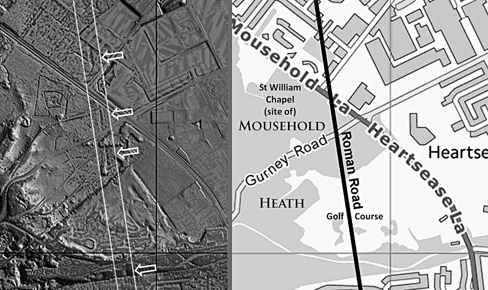
(1) Brampton to Caistor St Edmund, Roman Road (TG 22287 24016 – TG 23659 03832): a road south from the small Roman town of Brampton had long been known.Footnote 104 The accepted and widely published destination for this road was Thorpe St Andrew, a small settlement 3 km to the east of Norwich. With the advent of LiDAR this has been shown to be incorrect, with the actual route and destination being to Caistor St Edmund, the walled civitas capital of the Iceni. For its first 1.5 km, the modern road from Brampton to Buxton follows the Roman course, but south of there little of the modern road coincides with the Roman line. LiDAR shows it clearly in the fields first east of the modern road (TG 23120 20800) then west (TG 23412 19445), taking a much straighter course. At Frettenham, the previously accepted wisdom was that the road dog-legged to the east for a course towards Thorpe St Andrew. A visit to the suggested marsh crossing on this route at Beck Farm (HER 22951) revealed this was far too narrow to be a Roman road, plus no LiDAR traces align with it. There is, however, considerable LiDAR evidence to show that the road continued straight on via Spixworth Bridge (TG 23894 16459) and thence to Redmayne Rugby Grounds (TG24280 13750). Extrapolating the course onwards across suburban Sprowston showed that the road must have crossed Mousehold Heath. Mousehold Heath is a large open woodland/parkland area north-east of Norwich city centre, but it has been subject to intensive disturbance in the past. Amazingly, there were at least three excellent surviving lengths of agger visible in the LiDAR data continuing the alignment (TG 24792 10630, TG 24821 10430, TG 24838 10319) (fig. 20). South of Mousehold, an old straight boundary on the OS First Edition Map and Lion Wood Road confirm the line was targeting a natural valley in Lion Wood for the road's descent to the river Yare. Here, in 1961, on the north bank of the Yare, was found what was referred to as a possible bridge approach.Footnote 105 From the river Yare crossing the road is almost certainly overlain by the straight modern road, appropriately part of Boudicca Way. At the Caistor site, and predating the city walls, there is a diagonal road heading north-east. This points towards Boudicca Way and our river Yare crossing, so can only have been our road.
Brampton to Caistor St Edmund Roman road: the course of the Roman road across Mousehold Heath. Four distinct traces are visible in the LiDAR image (left).

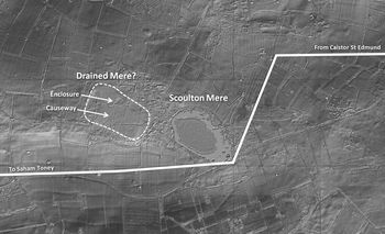
(2) Caistor St Edmund to Saham Toney, Roman Road (TG 23659 03832 – TF 88994 00682): the Norfolk Historic Environment Records (HER) currently record this road as two separate ones: the first east from Saham Toney (HER8786) and the second west from Caistor (HER19725). Not only was a connection missing but, in addition, the two roads did not align. LiDAR has now enabled the connection to be made, creating a through route from Caistor St Edmund to Saham Toney.Footnote 106 However, a new question arose as to why this route makes a huge 70-degree dog-leg around Scoulton Mere. The road is clear in the LiDAR data heading west from Caistor and passing Wymondham on its northern side. North-west of the latter it passes the temple site at Crownthorpe, where the HER line drifted offline. LiDAR revealed the Roman road continuing very directly via Hackford and as far as 3 km west of Hingham, where the road, at first inspection, appeared to come to a dead end (TF 99470 02273), just north of Scoulton Mere. A 3D virtual reality LiDAR model revealed the road took a 70-degree turn to the south, followed by another of around 68 degrees on the southern edge of the Mere (TF 99000 01046) (fig. 21). Originally, the Mere appears to have been about twice as large as it is now, and the west drained mere has indications of a settlement within it reached by causeways. Was this the location of a religious or ritual site that was important enough to force a dog-leg turn in the road? Beyond Scoulton Mere, the straight main road through Watton (B1108), which has always been assumed to be Roman, has now been connected to the road from Caistor, and can be confidently dated to the Roman period.
Caistor St Edmund to Saham Toney Roman road: LiDAR image showing the unusual change of direction in the Roman road. The probable drained west Mere is also indicated.

SUFFOLK
(1) Great Whelnetham, Fentons Farm, Stanningfield Road (TL 8760; WLG 038): an archaeological excavation revealed three distinct phases of Roman activity.Footnote 107 The earliest dates to the first to second century a.d. and consists of a large number of possible quarry pits which contained only minimal artefactual assemblages. The second phase comprises a substantial north-west–south-east boundary ditch which ran across the site. The third phase consists of a late Roman inhumation cemetery in which the remains of at least 69 individuals were interred, some deposited directly into the Phase 2 ditch. It is noteworthy that a number of these individuals had been decapitated at time of death (rather than post-mortem), suggesting they may have been executed. Sparse grave goods include bone combs and a number of small purple beads. The site is positioned over an interesting geological feature, consisting of a band of sandy material flanked by clayey deposits rich in gravel; it seems likely that the archaeology either targeted or was influenced by this feature.
(2) Haughley, land west of Fishponds Way (TM 0300 6170): excavation of a 0.4 ha area adjacent to a tributary of the river Gipping investigated a rectangular mortuary enclosure, measuring 12 m east–west by 8 m north–south and surrounded by a single, continuous ditch. The interior of the enclosure contained three cremation burials, dated to the mid- to late first century a.d. based on the associated pottery. Two of the burials were discovered during the earlier trial-trench evaluation: one was largely intact and contained in a coarse, sandy, reduced-ware jar, datable to c. a.d. 40–100; the other was heavily truncated, comprising just a few grams of cremated bone and the base of a fine, sandy, buff-ware vessel (mid- to late first century a.d). The third cremation found during the excavation consisted of a small pit containing a deposit of cremated bone, over which large sherds from an apparently deliberately broken ring-necked flagon (a.d. 70–100) had been laid. These were overlain by ash and other pyre debris, which included fragments of a burnt Langton Down-type brooch and 100 hobnails. The latter do not display any evidence of having been burnt, so the shoes from which they came were probably placed in the burial complete rather than in the pyre. False oat grass culm nodes found in soil samples from this cremation could represent part of the pyre fuel, a ritual inclusion or an accidental inclusion (along with associated grassland weed seeds) of a plant growing in the vicinity of the cremation pyre. False oat grass has been found in a number of other Roman cremation burials from Britain and north-western Europe; the significance of this is as yet unclear. The mortuary enclosure is an unusual feature in a rural context and suggests the presence of a previously unknown moderate- to high-status settlement in this locality. There are antiquarian records of richly furnished mid-first-century burials being found in this part of the Gipping valley, and a late Iron Age to Roman farmstead with a ‘villa’-type main building and two bath-houses has been excavated at Cedars Park, Stowmarket, 4 km to the south-east.Footnote 108
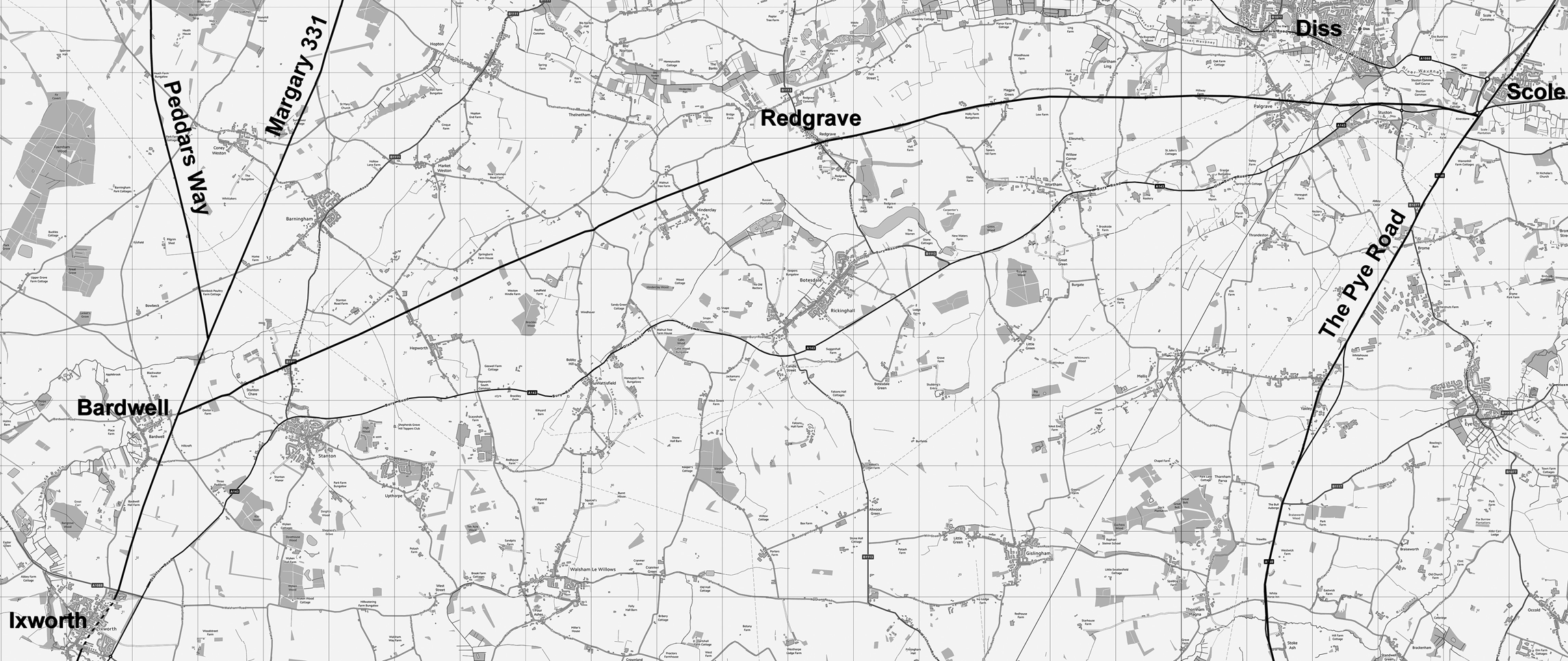
(3) Ixworth (Bardwell) to Scole, Roman Road (TL 94690 73783 – TM 14508 78325): a previously unknown Roman road has been located, using LiDAR imagery, that links the Roman settlements of Ixworth and Scole (fig. 22).Footnote 109 Heading north from Ixworth, the route initially follows the combined Peddars Way/Margary 331 road before branching off at Bardwell (TL 94690 73783). The alignment is ostensibly straight, passing north of Hinderclay (TM 01748 76950) and on to Redgrave (TM 04499 77933). The alignment becomes predominantly easterly when south of Diss, where Millway Lane partly overlies the road (TM 09485 78623). Finally, the route passes just to the north of Stuston (TM 13215 78524) and would have joined the Pye Road (TM 14508 78325), although the precise position is difficult to judge due to modern road improvements. The settlement of Scole would then have been reached a short distance north over the river Waveney via the Pye Road. It was to be expected that these two extensive settlements would have had a connecting road. The significance of this road is that it provides the most practical route from Caistor St Edmund to Ixworth, at a distance of 33 miles.
Ixworth (Bardwell) to Scole Roman road: route plan of the newly discovered Roman road connecting the Roman settlements of Ixworth and Scole. (OS Opendata base mapping)

SUPPLEMENTARY MATERIAL
For supplementary material for this article please visit https://doi.org/10.1017/S0068113X20000434