

INTRODUCTION
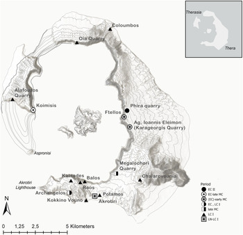
The study of prehistoric Therasia has its roots in the nineteenth century, with the extraction of Theran earth from the Alafouzos Quarry in the south of the island, and is associated with contemporary scientific interest in the volcanic eruptions of Santorini (Fouqué Reference Fouqué and McBirney1998). The study of the history of these first excavations (Tzachili Reference Tzachili2005; Reference Tzachili2006) and the identification of a Late Cycladic building originally brought to light by the 1866–7 excavations of Alafouzos and Nomikos, and subsequently by Fouqué (Fouqué Reference Fouqué and McBirney1998), formed the starting point for the broader interdisciplinary project ‘Island Cultures in a Diachronic Perspective: The Case of Therasia’ (Palyvou and Tzachili Reference Palyvou and Tzachili2015; Sbonias and Tzachili, Reference Sbonias and Tzachiliforthcoming), from 2007 onwards. The intensive archaeological surface survey (Sbonias, Farinetti and Kordatzaki Reference Sbonias, Farinetti, Kordatzaki, Palyvou and Tzachili2015; Efstathiou Reference Efstathiou, Palyvou and Tzachili2015; Vogkli Reference Vogkli, Palyvou and Tzachili2015; Farinetti et al. Reference Farinetti, Athanasiou, Sarris and Sbonias2013; Farinetti, Reference Farinetti, Sbonias and Tzachiliforthcoming), the geological survey to establish the geological structure and palaeotopography of Therasia (Vougioukalakis Reference Vougioukalakis, Palyvou and Tzachili2015; Vougioukalakis, Farinetti and Christopoulou, Reference Vougioukalakis, Farinetti, Christopoulou, Sbonias and Tzachiliforthcoming), and the geophysical survey for the correlation of surface densities of pottery with subsurface linear structures related with the built environment and anthropogenic activity (Sarris, Kalayci and Papadopoulos, Reference Sarris, Kalayci, Papadopoulos, Sbonias and Tzachiliforthcoming), in conjunction with the ongoing excavation of the prehistoric settlement at the site of Panaghia Koimisis at the south-east end of present-day Therasia (Sbonias, Tzachili and Moullou Reference Sbonias, Tzachili and Moullou2015; Sbonias et al. Reference Sbonias, Tzachili, Efstathiou and Palyvouforthcoming), have created the conditions for a more comprehensive approach to the archaeological landscape of the island (Fig. 1).Footnote 1
Pre-eruption Thera with prehistoric sites on the island (reconstruction of pre-eruption Therasia by G. Vougioukalakis and E. Farinetti).

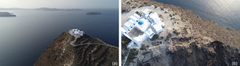
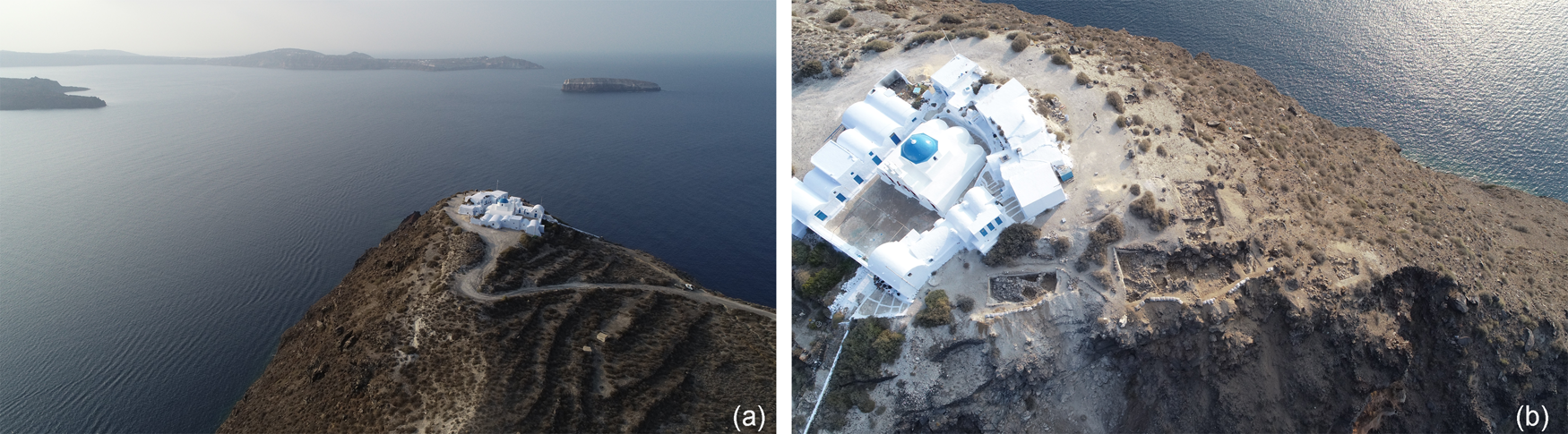
The prehistoric settlement of Panaghia Koimisis is one of the centres of habitation identified along the east caldera of the island by the intensive surface survey (Sbonias, Farinetti and Kordatzaki Reference Sbonias, Farinetti, Kordatzaki, Palyvou and Tzachili2015, 50–1; Sbonias, Tzachili and Moullou Reference Sbonias, Tzachili and Moullou2015, 61–9). The upper slopes of the caldera are dotted with the impressive volcanic rocks of Thirasia lavas (cf. Vougioukalakis Reference Vougioukalakis, Palyvou and Tzachili2015 for the geological formations at the caldera cliff of Therasia), an attractive site for habitation in various periods when security and the natural defences provided by the heights were a priority. The settlement occupies the top and the upper terraces of the hill at the south-east end of the present-day island (Fig. 2a) and forms part of the wider prehistoric occupation, which extended across the southern end of Bronze Age Therasia and has been gradually coming to light in recent years. The area of occupation includes the previously excavated Late Cycladic building at the Alafouzos Quarry, lower down and to the west (Fig. 1) (Tzachili Reference Tzachili2006, 111–45; Sbonias, Tzachili and Moullou Reference Sbonias, Tzachili and Moullou2015, 67–9, fig. 10), as well as other isolated scatterings of surface material, which are difficult to interpret due to the thick layers of tephra from the Minoan eruption covering the prehistoric terrain (Sbonias, Farinetti and Kordatzaki Reference Sbonias, Farinetti, Kordatzaki, Palyvou and Tzachili2015, 50–1, fig. 16; Sbonias, Tzachili and Moullou Reference Sbonias, Tzachili and Moullou2015, 59, fig. 3). They do, however, reveal the importance of the island's prehistoric habitation. The aim of the systematic excavation launched in 2014 at the Panaghia Koimisis site was to investigate the part of the installation preserved on the upper terraces of the hill (Fig. 2b),Footnote 2 and to study the relationships between the settlement and the rest of Thera and Akrotiri, where the earlier Bronze Age phases are preserved in a piecemeal fashion under the Late Cycladic town (Sotirakopoulou Reference Sotirakopoulou1999; Reference Sotirakopoulou, Brodie, Doole, Gavalas and Renfrew2008b; Nikolakopoulou et al. Reference Nikolakopoulou, Georma, Moschou, Sofianou, Brodie, Doole, Gavalas and Renfrew2008; Nikolakopoulou Reference Nikolakopoulou2019a), placing Therasia in the Cycladic settlement network (Kordatzaki et al. Reference Kordatzaki, Sbonias, Farinetti and Tzachili2018). Due to the location of the site at the southern end of Therasia, opposite Aspronisi and the Akrotiri Lighthouse, the study was also intended to shed light on the post-eruptive sinking of the caldera, and on the changing forms of the pre-eruptive caldera (Vougioukalakis Reference Vougioukalakis, Palyvou and Tzachili2015; Vougioukalakis, Farinetti and Christopoulou, Reference Vougioukalakis, Farinetti, Christopoulou, Sbonias and Tzachiliforthcoming).
(a) Aerial image of the Koimisis hill at the south end of Therasia seen from the north, with Aspronisi and the Akrotiri Peninsula in the background and (b) aerial image of the hill with excavation trenches in the south-east hillside (seen from the south).
GEOMORPHOLOGY, ENVIRONMENT AND LOCATION OF THE SETTLEMENT
The Bronze Age volcanic caldera formed by the destructive Cape Riva eruption 21,000 years ago shaped the topography of the inhabited area in prehistoric times (Vougioukalakis Reference Vougioukalakis and Danezis2001; Reference Vougioukalakis2006; Reference Vougioukalakis, Palyvou and Tzachili2015). The prehistoric site at Panaghia Koimisis stands on an imposing hilltop rising over the south-east tip of the island (Fig. 2a). The terrain is steep, with sheer cliffs falling away sharply to the south (Fig. 2b); these were created when the island of Therasia was split off from Aspronisi by the great Minoan eruption. Οn the south slope, immediately below the monastery, where the layer of tephra from the Minoan eruption covers the surface, there are modern terraces supported by low walls up to the brow and the upper cliffside of the caldera. On the gentler slopes of the south-east hillside are small natural stepped terraces, which form part of the pre-eruption terrain preserved on the upper hillside.
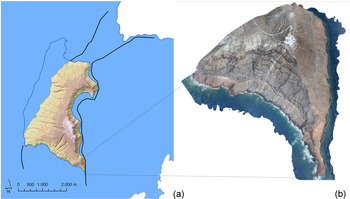
The geological study, the surface survey and the geophysical survey helped clarify the topography and limits of the settlement (Vougioukalakis Reference Vougioukalakis, Palyvou and Tzachili2015; Sbonias, Farinetti and Kordatzaki Reference Sbonias, Farinetti, Kordatzaki, Palyvou and Tzachili2015; Sbonias, Tzachili and Moullou Reference Sbonias, Tzachili and Moullou2015; Sarris, Kalayci and Papadopoulos, Reference Sarris, Kalayci, Papadopoulos, Sbonias and Tzachiliforthcoming). In contrast to the thick layers of tephra covering other parts of the island, on the Koimisis hill the deposits of the Minoan eruption gradually lessen moving upwards. They cover the level hilltop to a maximum visible depth of around 2 m, gradually thinning on the south slope and completely absent on the terraces on the south-east and east slopes, part of the earlier Cape Riva caldera, where the pre-eruption surface terrain is preserved (Fig. 3b; the pre-eruption surface is visible on the slope at the right part of the image) (Vougioukalakis Reference Vougioukalakis, Palyvou and Tzachili2015, 24–5; Vougioukalakis, Farinetti and Christopoulou, Reference Vougioukalakis, Farinetti, Christopoulou, Sbonias and Tzachiliforthcoming). The collapse here did not start from the brow of the caldera but lower down, near sea level. Thus the picture of the prehistoric terrain is preserved on the south-east and east slopes, which presumably provided access to the hilltop, judging from the inhabited terraces, the surface finds and the landscaping that extend quite low down the hillside, and also the path that winds its way among the volcanic rocks. Here the limits of the pre-eruption caldera must have been essentially the same as they are now, with part of it forming the walls of the extant caldera (Fig. 3a; the blue line shows the present coastline of the island and the thicker black line the suggested limits of the pre-eruption caldera) (Vougioukalakis Reference Vougioukalakis, Palyvou and Tzachili2015; Vougioukalakis, Farinetti and Christopoulou, Reference Vougioukalakis, Farinetti, Christopoulou, Sbonias and Tzachiliforthcoming). Just as today, the domes and flows of the Thirasia lavas were visible on the hilltop, on the upper slopes of the caldera, as these volcanic rocks were incorporated into the structures of the Koimisis prehistoric settlement with the addition of high retaining walls.
(a) Pre-eruption Therasia compared to the island as it is today (G. Vougioukalakis and E. Farinetti) and (b) 3D model of the morphology of the Koimisis hill based on drone flights (N. Michailidis).
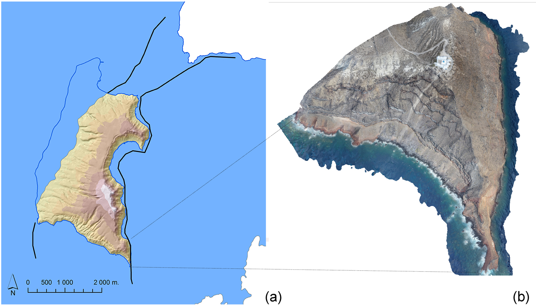
The sheer cliffs at the southern end of modern Therasia, on the contrary, form part of the Minoan caldera (Fig. 3b) (Vougioukalakis, Farinetti and Christopoulou, Reference Vougioukalakis, Farinetti, Christopoulou, Sbonias and Tzachiliforthcoming). The settlement walls leading to the edge of the cliff vividly demonstrate how the south side of the hill collapsed from the height of the brow of the caldera, taking part of the settlement with it (Fig. 2b). However, small details, such as the modification to the rectangular plan of the rooms near the south edge of the present caldera, suggesting that they were close to a slope, and the pre-eruption terrain preserved on tiny islets near the south slope, testify to the steepness of the original hill near what is now its south cliffside.
According to the proposed reconstructions of the morphology of pre-eruption Thera, the south part of Therasia was a plain extending across what is now the bay between Therasia and Aspronisi (Aston and Hardy Reference Aston, Hardy, Hardy, Keller, Galanopoulos, Flemming and Druitt1990; Friedrich, Seidenkrantz and Nielsen Reference Friedrich, Seidenkrantz, Nielsen, McGuire, Griffiths, Hancock and Stewart2000, 74, fig. 3; Druitt and Francaviglia Reference Druitt and Francaviglia1992; Vougioukalakis Reference Vougioukalakis2006; Reference Vougioukalakis, Palyvou and Tzachili2015, 24–6; Nomikou et al. Reference Nomikou, Druitt, Hübscher, Mather, Paulatto, Kalnins, Kelfoun, Papanikolaou, Bejelou, Lampridou, Pyle, Carey, Watts, Weiß and Parks2016, 5, fig. 6a; Karátson et al. Reference Karátson, Gertisser, Telbisz, Vereb, Quidelleur, Druitt, Nomikou and Kόsik2018, fig. 1). The shallow seabed south of modern Therasia, called ‘trapeza’ (table) by the locals and visible on bathymetric charts (Nomikou et al. Reference Nomikou, Druitt, Hübscher, Mather, Paulatto, Kalnins, Kelfoun, Papanikolaou, Bejelou, Lampridou, Pyle, Carey, Watts, Weiß and Parks2016, fig. 1a; Athanasas et al. Reference Athanasas, Bourlès, Braucher, Druitt, Nomikou and Léanni2016, fig. 1), supports the view that the south part of Therasia was joined to Aspronisi (Fig. 1). This means that the Koimisis settlement was sited in an area particularly favourable for habitation, protected from the northerlies and rising high above the edge of the plain, overlooking both the plain and the coast (Vougioukalakis Reference Vougioukalakis, Palyvou and Tzachili2015, 24–5).
As regards the shape of the pre-eruption caldera, geologists, starting from the original theory of a classic single volcanic cone, concluded for around three decades that Santorini was a single island extending from the Akrotiri Lighthouse to Aspronisi, with a small strait to the south-west allowing the sea to enter a central caldera.Footnote 3 The north part of the caldera bay was quite shallow, as evidenced by the development of brown algae colonies that created characteristic stromatolites, 17,000-year-old fragments of which are found on Therasia and northern Thera (Eriksen et al. Reference Eriksen, Friedrich, Buchardt, Tauber, Thomsen, Hardy, Keller, Galanopoulos, Flemming and Druitt1990; Vougioukalakis Reference Vougioukalakis, Palyvou and Tzachili2015, 24). It has recently been argued, based on new efforts to map the Santorini seabed, that there was a strait on the north side of the caldera but no outlet to the south-west (Nomikou et al. Reference Nomikou, Druitt, Hübscher, Mather, Paulatto, Kalnins, Kelfoun, Papanikolaou, Bejelou, Lampridou, Pyle, Carey, Watts, Weiß and Parks2016; Karátson et al. Reference Karátson, Gertisser, Telbisz, Vereb, Quidelleur, Druitt, Nomikou and Kόsik2018). Although the existence of a northern strait is probable, the hypothesis that there was a unified shoreline on the south side of the caldera, between Therasia and the Akrotiri Lighthouse, is not supported either by the evidence from the research into the seabed of the Santorini caldera or by the archaeological finds associated with the site and the characteristics of the Koimisis settlement. The dating of the settlement to the Early Cycladic period, and its categorisation among Early Bronze Age fortified settlements like that of Kastri, Syros, which were located on high hills near the sea and controlled the bays below, suggest its proximity to the south strait connecting the caldera to the sea, which was probably deeper than the north part of the basin, providing a safe lee harbour (Fig. 1). The low height of the pre-eruption layers on Aspronisi, which are very close to sea level, also argues for the fact that the coastline as far as the Akrotiri peninsula was not continuous (Vougioukalakis, pers. comm.).
METHODOLOGICAL APPROACHES ΤΟ THE STUDY OF THE PREHISTORIC SETTLEMENT
The Koimisis hill was studied using non-invasive methods, such as intensive surface survey and the application of geophysical methods, combined with excavation trenches. Comparative utilisation of the results of these investigations both adds to our understanding of the site and helps us evaluate the reliability of the methods and techniques used.
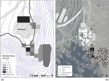
The surface material was collected using a grid of 20 x 20 m squares (Fig. 4a). The bulk of the pottery collected spans the period from the Early Cycladic to the Late Roman/Early Byzantine period and is related to the prehistoric site on the south-east slopes of the hill and an ancient site, probably a sanctuary, at the location of the present Monastery of Panaghia Koimisis (Sbonias, Farinetti and Kordatzaki Reference Sbonias, Farinetti, Kordatzaki, Palyvou and Tzachili2015, 45–8). Most of the ancient material, which is dated in the Early Archaic, Archaic-Classical, Classical-Hellenistic and Roman periods, comes from the survey transects to the north-west of the hill and includes plain and fine black and red gloss pottery, sherds from black- and red-figure vases, as well as Late Roman/Early Byzantine material from domestic pottery of the fifth to seventh centuries ad.Footnote 4 The high pottery densities in the north squares of the site grid in Fig. 4a are related to material from the Archaic to Roman periods, while the pottery densities in the squares on the south-east slopes of the hill are associated with prehistoric material (Fig. 4b).
(a) Overall surface pottery density on Koimisis hill (total counts of sherds per square) and (b) distribution of prehistoric pottery on the survey grid (counts of diagnostic prehistoric sherds per square where 1 dot = 1 sherd). The location of the geophysical plots is also marked on the map.

The surface distribution of prehistoric pottery from the pre-eruption layers, which has been brought to the surface by erosion (Fig. 4b), includes diagnostic pottery and ceramics dated to the prehistoric period on the basis of the surface treatment and fabric (Kordatzaki et al. Reference Kordatzaki, Sbonias, Farinetti and Tzachili2018). The largest concentrations are found on the hillsides and the natural steps on the south and south-east terraces, where the pre-eruption soils are visible on the surface. The hilltop itself, measuring approximately 1900 sq m, is mostly occupied by the modern Monastery of Panaghia Koimisis (Dormition of the Virgin) and is covered by the layer of the Minoan eruption. Thus, the prehistoric pottery distribution should be assessed taking into account the limits of the visibility of the pre-eruption surface (Fig. 4a). Small concentrations of prehistoric pottery at the north-east and east ends of the flat hilltop (Fig. 4b), where the east slope begins to erode and the pre-eruption layers are exposed, suggest the presence of prehistoric remains around the hill.
The prehistoric sherds from the survey assemblage come from various types of vessel (bowls, open vessels, storage vessels), and the vast majority are mostly plain and monochrome-slipped sherds, which are often polished or burnished. They are associated with various Early Cycladic low-calcareous fabrics, local or imported. A small percentage of the surface pottery is correlated with pale, higher calcareous fabrics of the late Middle Cycladic period and is associated with the Cycladic White Ware, which comprises plain, monochrome-slipped, dark-on-light pattern-painted and bichrome-painted sherds (Kordatzaki et al. Reference Kordatzaki, Sbonias, Farinetti and Tzachili2018, 4–6, figs 5 and 6). The study of the technological characteristics of the surface pottery and the petrographic analysis by G. Kordatzaki, who classified and studied the fabrics of the survey assemblage, taken together with issues of pottery provenance and technology, and the study of pottery networks between Therasia/Thera and other Cycladic islands, helped us date the bulk of the prehistoric surface material, which was mostly associated with coarse and undiagnostic body sherds, and thus estimate the period-by-period distribution of the prehistoric material on the surface (Kordatzaki Reference Kordatzaki, Palyvou and Tzachili2015; Kordatzaki et al. Reference Kordatzaki, Sbonias, Farinetti and Tzachili2018, 6–15). This suggests differentiations in the size of the settlement during different Bronze Age periods, which were confirmed by the excavation. The material of the Early Bronze Age, when the settlement was at its largest, is more widely scattered on the steeper slopes than that of the Middle Cycladic period, the remains of which are concentrated on the upper terraces and probably the top of the hill, now lying under the layers of the Minoan eruption (Sbonias, Tzachili and Moullou Reference Sbonias, Tzachili and Moullou2015, 66, fig. 8).
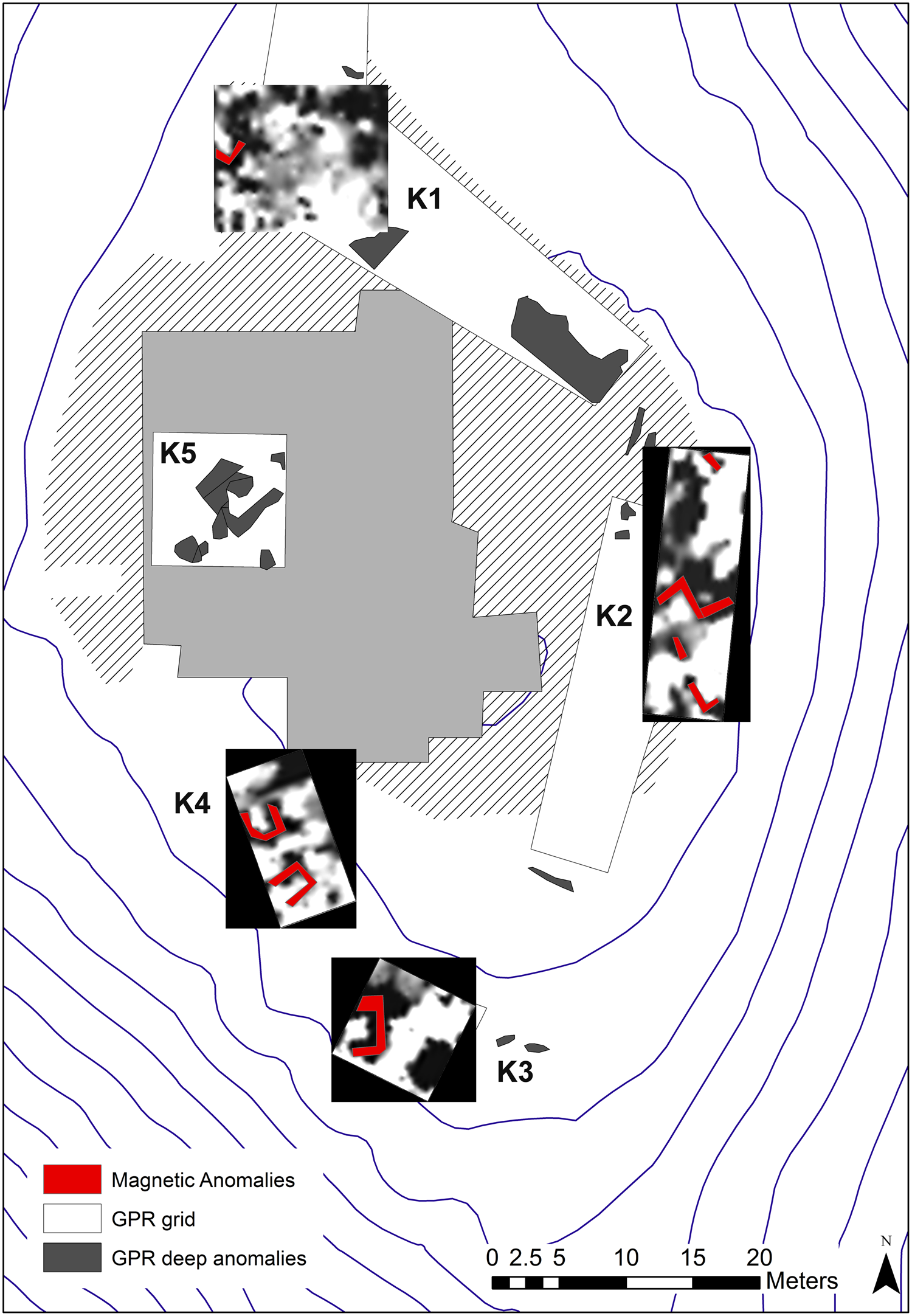
Further information on the area of the settlement is provided by the geophysical survey (Sarris, Kalayci and Papadopoulos, Reference Sarris, Kalayci, Papadopoulos, Sbonias and Tzachiliforthcoming). The methods employed were magnetometry techniques and ground penetrating radar (GPR), which through horizontal depth slices can provide evidence on the stratigraphy of the site. Grids were placed around the hilltop, along the road leading to the church and on the terraces to the north-west of the monastery, on the flat hilltop north and east of the monastery complex, towards the south and south-east abrupt slopes of the hill and in the internal courtyard of the monastery (Fig. 4b for the location of the geophysical plots in relation to the survey grid). The initial layouts of survey grids for magnetic measurements (K1: 27 x 6 m, K2: 27 x 9 m, K3: 25 x 7 m, K4: 10 x 5 m) were extended for complete GPR coverage (K1: 42 x 6 m; K2: 37 x 9 m; K4: 15 x 5 m; K5: 14 x 5 m) (Fig. 5). Despite the difficulties imposed by the volcanic environment, the geophysical survey identified localised anomalies on the south and south-east terraces of the hillside and around the flat hilltop to the north and east of the monastery, which may be attributed to subsurface linear structures (Sarris, Kalayci and Papadopoulos, Reference Sarris, Kalayci, Papadopoulos, Sbonias and Tzachiliforthcoming, figs 6 and 7). The GPR survey indicated relics of an older subsurface structure within the internal courtyard of the Koimisis Monastery (Fig. 5). The ongoing excavation has confirmed these general trends recorded by the geophysical investigation and allows us to compare the data. The registered geophysical anomalies do not offer a clear understanding of the individual structures; their definition was also a difficult task during the excavation, due to the large amount of fallen building material. On the other hand, walls or areas with fallen stones have been detected by the geophysical prospection and correspond to high magnetic readings. Other features were detected by the GPR, while the interior of certain buildings, for example the fill with debris in the apse of the ellipsoidal building (see below), corresponds to low magnetic anomalies. The large rectangular structure detected by the GPR survey within the churchyard, and initially associated with a possible earlier structure below the modern church, may also be linked to the prehistoric remains of the site, since strong, straight walls, with a length of about 7 m and a preserved height of up to 2 m, were revealed in trench BB during the 2018 excavation season and are currently under investigation (structures visible in Fig. 2b, in the excavation trench on the left, south of the monastery courtyard).
Results of the geophysical investigation (magnetic measurements and their interpretation, and interpretation of the GPR anomalies, based on the results of the geophysical survey by Sarris, Kalayci and Papadopoulos Reference Sarris, Kalayci, Papadopoulos, Sbonias and Tzachiliforthcoming).

The surface pottery distribution and the geophysical survey results, together with those of the ensuing excavation, which more precisely determined the relationship of the surface material to the building remains and the post-depositional processes, allow us to calculate the area of habitation on the hilltop and the upper terraces of the south and south-east slopes: it covered approximately 3500 sq m or 0.35 ha. To this area must be added the part of the settlement that has collapsed south of the present brow of the caldera due to the Minoan eruption. Possible habitation on the north and north-west slopes of the hill cannot be ascertained due to the fact that these parts are covered by the layers of the Minoan eruption. Current calculations show that the area of the original settlement associated with the built space on the top and upper terraces of the hill would not have exceeded 0.4 ha, making it comparable in size to other small fortified hilltop sites such as Kastri, Syros (0.5 ha) (Broodbank Reference Broodbank2000, 214–15) and Markiani, Amorgos (0.3 ha) (Marangou et al. Reference Marangou, Renfrew, Doumas and Gavalas2006, 249). The Koimisis settlement was probably larger than several other tiny Early Cycladic II settlements such as Panormos, Naxos (0.0285 ha) (Angelopoulou Reference Angelopoulou2014, 20), Mount Kynthos on Delos (0.04 ha) (MacGillivray Reference MacGillivray1980; Broodbank Reference Broodbank2000, 177) and Korfi t'Aroniou, Naxos (0.08 ha maximum on the basis of the hilltop area) (Doumas Reference Doumas1965; Broodbank Reference Broodbank2000, 177), but smaller than other Early Bronze Age settlements in the Cyclades, such as Skarkos, Ios (1.1 ha) (Marthari Reference Marthari, Brodie, Doole, Gavalas and Renfrew2008, 71) and Dhaskalio (1.3 ha),Footnote 5 and the Aegean, such as Palamari, Skyros (1.7 ha) (Parlama et al. Reference Parlama, Theochari, Romanou and Bonatsos2015, 49). Of course, we do not know the dimensions of the part of the settlement which collapsed; the site may have been much larger.
OVERVIEW OF EXCAVATION TRENCHES AND PERIODS OF HABITATION
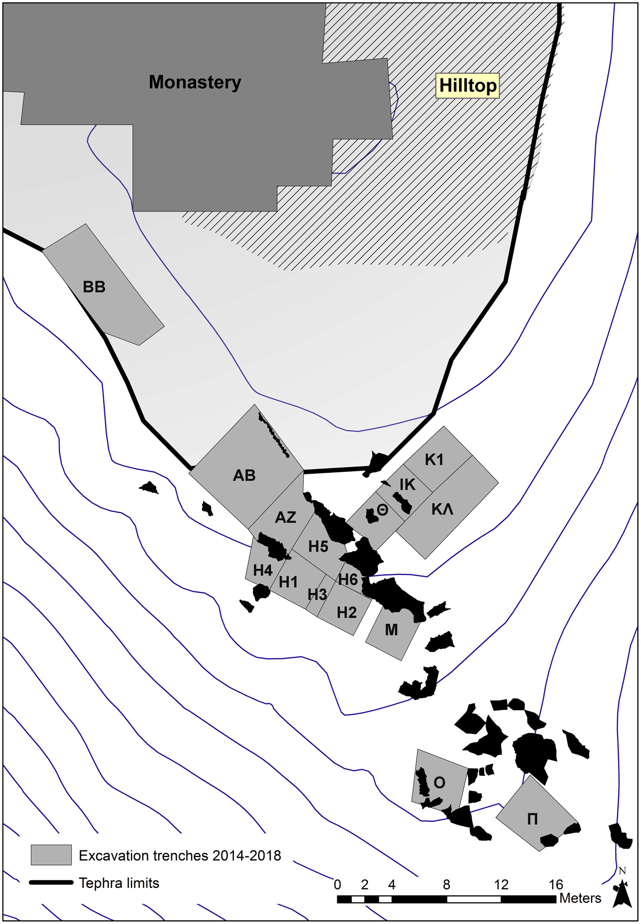
The trenches opened as part of the systematic excavation are located in the pre-eruption soils of the south and south-east hillsides (Fig. 6). Here we present the trenches dug between 2014 and 2017, which have been excavated down to the bedrock. The paper focuses on the architecture and periods of habitation of the settlement and not on other aspects of the economy of the site, the environmental finds and the material culture, which are still under study.Footnote 6 The narrowness of the terraces or natural plateaux on the present surface (4–7 m wide), in some cases supported by modern terrace walls, determined the size and orientation of the trenches and the excavation process. Remains of ancient terrace walls were not visible on the surface, while volcanic rocks, some of which formed part of the prehistoric built space, could be seen on the surface (marked in black in Fig. 6).
Koimisis hill with the location of the excavation trenches and the limits of the layer of the Minoan eruption.

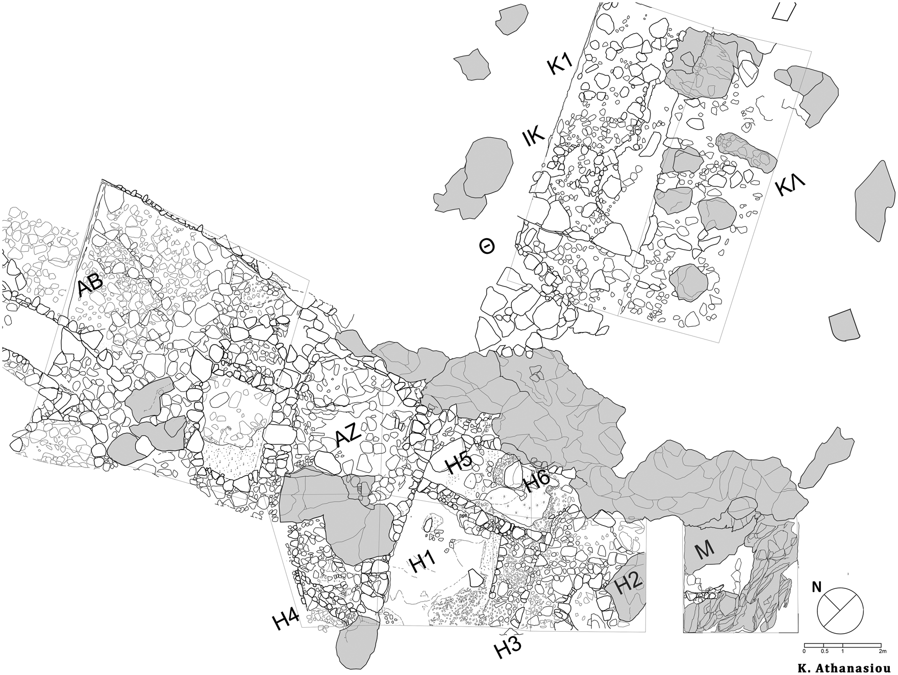
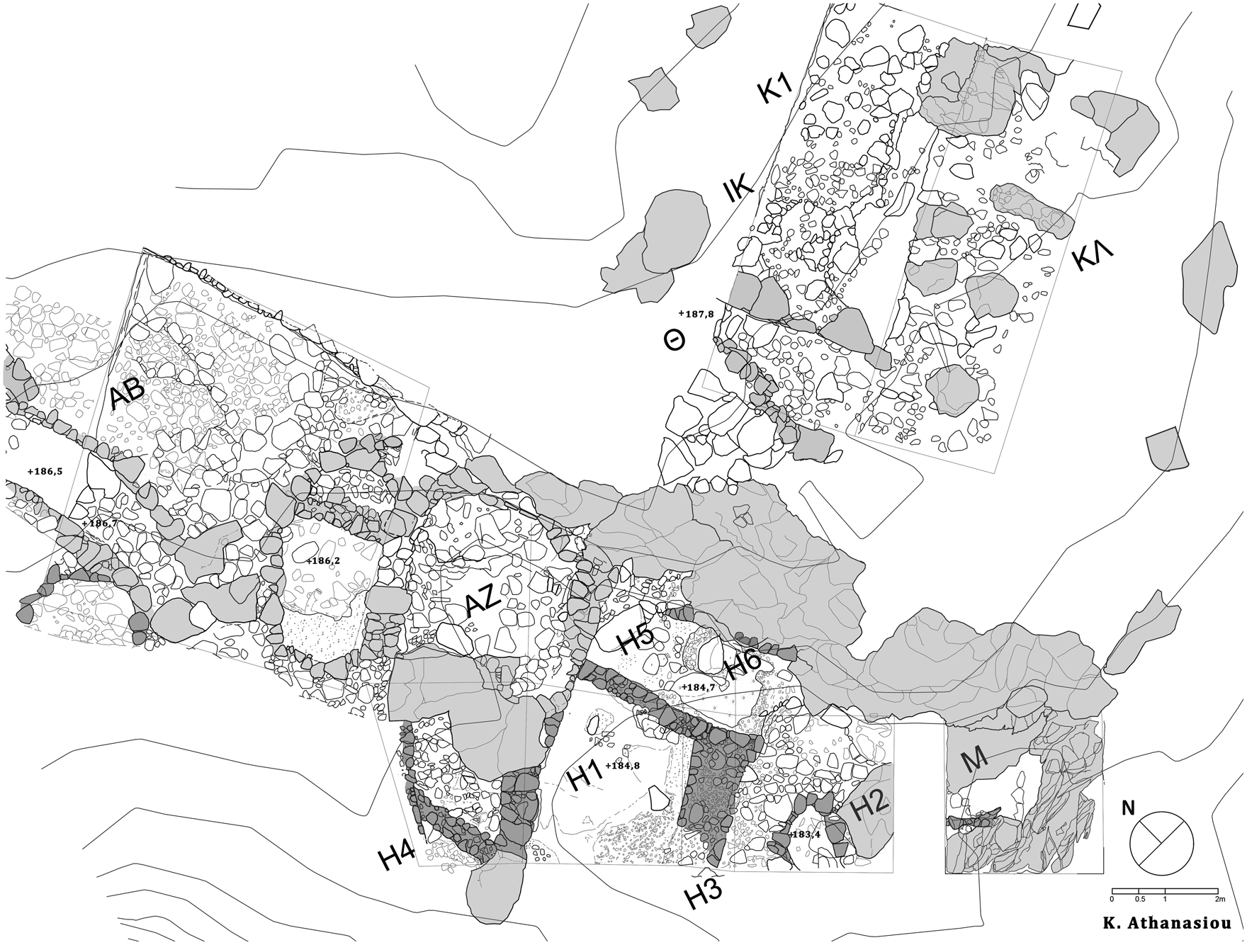
The main aim of the 2014 and 2015 seasons was to investigate the apparently deliberate arrangement of large volcanic rocks in rows at ‘regular’ intervals, which seemed to have been used to delimit manmade structures. During the 2014 season, five trenches were dug on two levels (Fig. 7): three (Μ, Η1, Η2) on the lowest terrace at the edge of the cliff, at + 185 m above sea level (a.s.l.), and two on the highest terrace on the east slope, directly under the monastery plateau, at + 188 m a.s.l. (trench ΙΚ and its southwards extension Θ). Work continued during the 2015 season, with the removal of balk Η3 between trenches Η1 and Η2, and the excavation of new trenches to the north (Η5 and Η6) and west (Η4). With the removal of the balks, the level area was unified, providing a full picture of the development of manmade structures on the elongated terrace on the south slope (Fig. 8a). The trenches of square H (trenches H1, H2, H3, H4, H5, H6) as well as trench M run along the present brow of the caldera, on an intermediate step of the upper south hillside. The terrace is delimited to the north by a row of large volcanic rocks forming a face on which the buildings stood, and to the south by the edge of the present caldera, where the south hillside collapsed during the Minoan eruption. No Minoan eruption deposits were preserved on the terrace, while pre-eruption terrain was visible on the surface of the soil during the excavation.
Architectural plan of the excavation area (K. Athanasiou).

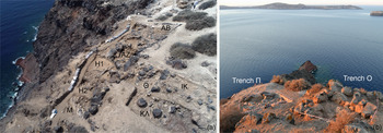
(a) Excavation trenches on the southern terrace along the brow of the caldera (AB, AZ, H1, M) and on the east slope (Θ, ΙΚ, ΚΛ) seen from the east and (b) trenches Ο and Π on the lower terraces of the south-east hillside seen from the north-west, with Aspronisi and the Akrotiri Peninsula in the background.

In 2014 trenches ΙΚ and Θ were excavated on the east slope, on the level just above and to the north of square H, and below the level of the monastery (Fig. 7). In 2015 these trenches were extended to the north (K1) and east (ΚΛ). They were intended to investigate the configuration of the steep east hillside and the access from the lower terraces to the hilltop (Fig. 8a). This eastern part of the slope is also heavily eroded and the Minoan eruption deposits are not preserved on the surface. The sheer rocks of Thirasia lavas, dropping steeply to the east, form a natural cliff on the lower east slope.
On the gentler south-east part of the slope, on the contrary, stepped terraces are formed (Fig. 8b), with the natural path down the hillside winding among them, almost down to the sea. This area preserves its pre-eruption configuration. The excavation trenches here were opened in 2016 and 2017 in two successive terraces (trenches Ο and Π), at + 180 m and + 176 m a.s.l. respectively, in order to identify the limits of the settlement on the south-east hillside and investigate the communication between the terraces there (Fig. 6). It emerged that the settlement did indeed extend south-east as far as trench O, while trench Π lay outside the settlement.
In 2016 and 2017 the excavation was extended westwards, to the terrace extending directly south of the hilltop to the rim of the caldera (trench ΑΒ, Fig. 6). This terrace is the westwards continuation of the terrace of square H, although it lies higher up the hillside, at + 187 m a.s.l. The deposits of the Minoan eruption were visible in places in the north part of the terrace. The surface survey also identified the upper surface of a large mortar of volcanic rock encased in the tephra from the Minoan eruption. In 2017, the removal of the intervening square AZ unified the areas of trenches AB and square H, revealing a continuous surface approximately 20 m long from east to west and roughly 6 m wide, extending between the face of volcanic rocks to the north and the caldera rim to the south, and allowing the investigation of the settlement in a single unified space (Fig. 7).
Settlement layout
An important element in understanding the topography and layout of the settlement is the shape and arrangement of the large volcanic rocks that jut from practically the whole surface of the hill, delimiting the ancient terraces and forming the areas suitable for building (Fig. 6). The long row of rocks running south-east to north-west along the slope south-east of the hilltop, around 13 m long and 3 m high, creates two different levels on the south-east slope (Fig. 7).
The upper level of the east slope, at + 187.8 m a.s.l., extends across the now quite steep east hillside. The excavation here provided information on the levelling of the slope to configure the built area and control access to the hilltop (Fig. 8a). Artificial terracing of the steep slope was revealed in trenches Θ, ΙΚ and Κ1, with a layer of tamped gravel (5–7 cm) laid on a bed of larger stones. Two solid walls running transversely between the rows of volcanic rock to the south and the artificial terraces to the north form a passageway between the two, delimiting access to the hilltop (trench Θ, Fig. 7). These walls are built of large volcanic rocks which at first glance look natural; their placement, however, is not. The coarse, dark pottery found here is Early Cycladic in date, suggesting that the area was landscaped during that period.
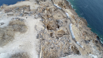
On the lower level of the south slope, at + 185 m a.s.l., part of the built space of the settlement was revealed between the row of volcanic rocks forming the north face of the terrace and the present south rim of the caldera (Fig. 9). The excavation on the level area (trenches AB, AZ, H and M) allowed us to understand the stepped layout along the east–west axis, which used a system of closed and open-air spaces, creating artificial terraces and using the rock formations, which were ingeniously incorporated in the structures.
Aerial photograph of the excavated area on the terraces south of the hilltop, on the edge of the caldera (trenches ΑΒ, AZ and trenches of square H seen from the south).

Trench AB
The west excavated end of the terrace (trench AB) lies at the highest level at + 187 m a.s.l. (Fig. 7). Its north end was partially covered by Minoan eruption deposits. The removal of these layers of ash and pumice, up to 90 cm thick, revealed an outdoor space paved with tamped gravel and medium-sized stones, on which was set a large mortar 0.67 m in height and 0.43 cm in diameter. A retaining wall delimits the terrace to the south-west, forming an alley to the west (Fig. 9). The pottery from the surface of the terrace is late Middle Cycladic in date, representing the final phase of use of the settlement. The landscaping of the area, however, dates from the Early Cycladic period, as evidenced by the ellipsoidal building of the same date set against the terrace lower down (see below) and by the pottery from the fill of the terrace.
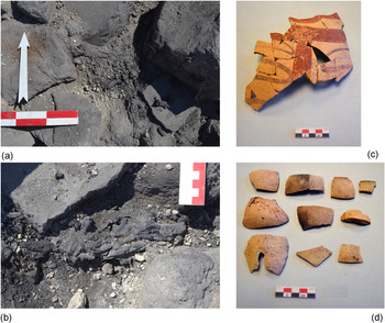
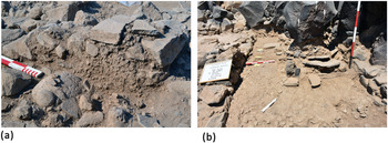
At the north-east end of the paved space in trench AB, directly under the layer of pumice from the Minoan eruption, were found pieces of a charred olive shrub, occupying the gaps among the partially burnt stones in a linear pattern (Fig. 10a, b). The trunk consisted of three larger pieces of wood in the gaps among the stones, interspersed with smaller twigs and pieces of charcoal from the main trunk. Everything lay under the layer of pumice of the Minoan eruption and in direct contact with it. The stones had traces of soot in places but the destruction layer as a whole did not, meaning that the possibility of a more extensive fire in the area is unlikely. The fact that the trunk was quite small and its location may suggest that the olive shrub sprouted on the surface of the abandonment layer of the site. The pottery from the findspot of the wood is late Middle Cycladic in date, which is the period of the final abandonment of the settlement (Fig. 10c, d). Figure 10c shows a sherd from a jug with bichrome matt-painted linear decoration of brown vertical wavy bands alternating with red vertical bands, an exact parallel of that found at Akrotiri (phase C) (Doumas Reference Doumas2016, 222; Nikolakopoulou Reference Nikolakopoulou2019a, 280, fig. 3.6; Reference Nikolakopoulou2019b, 224–5, pl. 104:1048, 531, pl. XLV). There were also cup sherds bearing limited traces of soot where they were exposed on the surface (Fig. 10d). The olive shrub was burned in conditions most probably related to the Minoan eruption, as suggested by the fact that it was immediately covered by the pumice layer. There is no thin layer of fill between the burned trunk and the pumice layer of the Minoan eruption, as is the case, for example, with the pottery lying on the surface of the abandonment layer of the settlement at the moment of the eruption. The picture of local concentrations of burned wood on the upper surfaces of the rock piles of the settlement destruction layer, contacting and under the pumice layer, was also observed in other areas of the excavation during the removal of the Minoan eruption layers.
Charred olive wood among the stones and pottery of the layer.

Radiocarbon dating of samples of the smaller twigs preserving parts of the bark was carried out using mass spectrometry at the Accelerator Mass Spectrometry Laboratory and the Laboratory of Tree-Ring Research at the University of Arizona (Hodgins et al. Reference Hodgins, Pearson, Wazny, Sbonias, Tzachili and Heaton2018). Four nearly cylindrical, small-diameter twigs from the main trunk were selected. Sampling was carried out directly under the bark, the last growing part of the tree when the Thera volcano erupted. The samples were also selected based on the visible semi-concentric rings, which, however, cannot be definitely interpreted as annual rings (Hodgins et al. Reference Hodgins, Pearson, Wazny, Sbonias, Tzachili and Heaton2018). Radiocarbon measurements on the outermost wood from these twigs gave an average date of 3318 +/-12 Radiocarbon (14C) years BP (uncalibrated dates Before Present), which is in agreement with radiocarbon determinations of the Santorini olive branch segments and other contexts just prior to the eruption (Friedrich et al. Reference Friedrich, Kromer, Friedrich, Heinemeier, Pfeiffer and Talamo2006; Manning et al. Reference Manning, Ramsey, Kutschera, Higham, Kromer, Steier and Wild2006). Thus, Therasia sample 88–1 Outer with a radiocarbon measurement of 3320 +/-22 14C years BP is statistically identical to the Santorini olive End segment reported by Friedrich with a measurement of 3331 +/-10 14C years BP (Friedrich et al. Reference Friedrich, Kromer, Friedrich, Heinemeier, Pfeiffer and Talamo2014) and has a comparable absolute date in the late seventeenth century bc, if the internationally agreed radiocarbon calibration curve IntCal13 (International Radiocarbon Calibration curve published in 2013) is applied to the Therasia sample. However, in light of new studies by Pearson et al. (Reference Pearson, Brewer, Brown, Heaton, Hodgins, Jull, Lange and Salzer2018), applying a new calibration dataset, which is based on annual measurements from bristlecone pine and Irish oak (ICCP17 calibration curve, developed as part of the ICCP-Interdisciplinary Chronology of Civilizations Project), might affect the absolute dating of the Therasia olive wood, pushing the dates into the first half of the sixteenth century bc (Pearson et al. Reference Pearson, Brewer, Brown, Heaton, Hodgins, Jull, Lange and Salzer2018, table 1; Hodgins et al. Reference Hodgins, Pearson, Wazny, Sbonias, Tzachili and Heaton2018).
The ellipsoidal building in trench AB
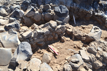
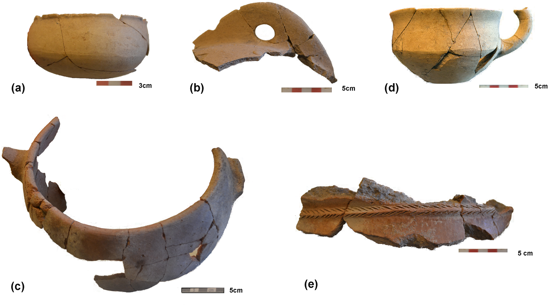
The excavation of trench AB revealed an ellipsoidal building of the Early Cycladic period, in contact with and partly encased in the stone-paved surface (Fig. 7). The building, 3.70 m long and 1.90 m wide, was constructed of large volcanic boulders (Figs 9 and 11). The west and north sides of the building, of which only the inner surface of the walls is visible, were encased in the terrace. The east wall, on the contrary, 1 m thick, is built of two courses of large stones forming its inner and outer surfaces. Two large jambs, monolithic up to the preserved height of the walls, one measuring 0.63 x 0.84 m, frame the doorway on the east side of the building. As has been confirmed in other areas of the excavation, the building of structures incorporating large volcanic rocks at the Koimisis settlement goes back to the Early Cycladic period, continuing with modifications into the Middle Cycladic. The stratigraphy in the area of the apse of the building reveals its different phases (Fig. 12a, b upper destruction layer, 12c substrate of the apse, 12d, e mixed context from the uppermost layer of the building). Local Cycladic White Ware of the Middle Cycladic period, including plain, monochrome-slipped, dark-on-light pattern-painted and bichrome-painted sherds, predominates in the fill layer, which contained building debris (Fig. 12a, b). In this layer the few pots of low-calcareous fabrics in red colour from medium-sized pots and larger vessels are not local but associated with imports from Naxos (the rich-in-granite fabric group Γ in Kordatzaki et al. Reference Kordatzaki, Sbonias, Farinetti and Tzachili2018, 8, figs 7e, f, 10, 11, 12 and 13) and the West Cyclades. This lack of local low-calcareous fabrics in the upper Middle Cycladic fill layer of the building matches the change in the Theran potting tradition in the late Middle Cycladic period from Theran low-calcareous Early Cycladic fabrics towards the higher calcareous Cycladic White Ware.Footnote 7 In the floor layer of tamped clay of the ellipsoidal building and in its substrate, however, the dominant group is the local low-calcareous coarse fabric with volcanic inclusions of the Early Cycladic period (Fig. 12c) (Fabric Group A in Kordatzaki et al. Reference Kordatzaki, Sbonias, Farinetti and Tzachili2018, 6–8, fig. 7a), associated with large, coarse vessels, with the exception of a few possible Naxian examples and only a few sherds of scored ware (of the high calcareous local fabric B in Kordatzaki et al. Reference Kordatzaki, Sbonias, Farinetti and Tzachili2018, 8–9). The interior cross-wall of the building, made of rubble (Fig. 11), which is only faced on the inside, is probably associated with a second building phase during which part of the ellipsoidal building was dismantled and the interior acquired a rectangular shape. The continuation of the excavation in 2017 and 2018 confirmed the ellipsoidal shape of the building on its southern end and completely revealed the doorway in the east long side, 1 m wide, between the two jambs, and a second floor at the level of the base of the jambs, approximately 25 cm lower than the previous one (Fig. 9), also associated exclusively with low-calcareous pottery of the Early Cycladic Period.
Ellipsoidal building with internal cross-wall. The photo shows the apse of the building (upper left), the two jambs on the right and the floor in front of the internal wall. The stones at lower right are part of the unexcavated fill of the building. At top right is trench AZ with natural rock faced with rubble wall.

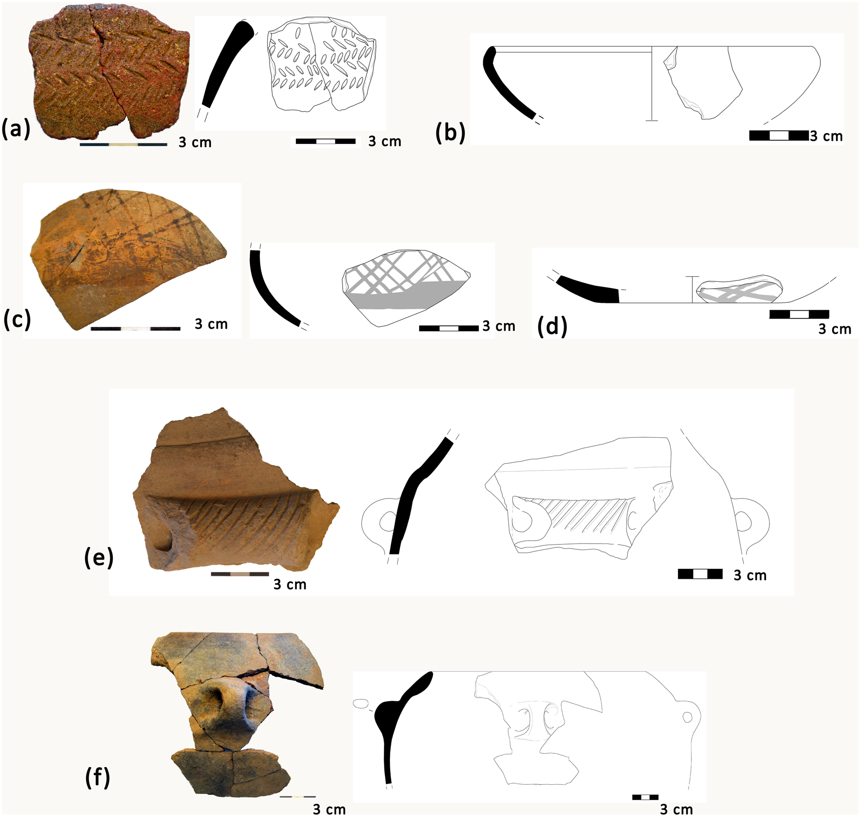
Trench AB. Pottery from the different layers of the ellipsoidal building: (a) and (b) from the upper layer with building debris; (c) from the substrate in the area of the apse; (d) and (e) from a mixed context of the uppermost level.

An example of an ellipsoidal, semi-subterranean building with walls faced on the inside with rubble walls is that of Ftellos in the Fira Quarries, dated to Early Cycladic III–early Middle Cycladic (Marthari Reference Marthari1982; Reference Marthari and Danezis2001, 106–9, figs 1, 2, 3; Friedrich Reference Friedrich2009, 176, fig. 10:24), while above-ground houses, probably with an apse, are found at the Early Cycladic settlement of Mount Kynthos on Delos (MacGillivray Reference MacGillivray1980, 4–8, figs 1, 2), Korfi t'Aroniou on Naxos (Doumas Reference Doumas1965, 44, pl. 2) and other Early Bronze Age settlements such as Early Bronze Age II Palamari (Bonatsos and Romanou Reference Bonatsos, Romanou and Parlama2015, 51–60, figs 2–8). A stone pit-shaped structure of late Early Bronze Age II has also been found at Christiana (Sotirakopoulou Reference Sotirakopoulou1999, 239–40, 257–8), although its size and underground location make it more similar to the stone structure of trench H2 at the Koimisis settlement, further to the east on the same terrace (see below). The ellipsoidal building of trench AB is set partly underground due to the inclination of the hillside and its adaptation to the higher terrace of trench AB.
Access to the ellipsoidal building was via an open-air or semi-outdoor courtyard (trench AZ), the surface of which had probably been raised to the level of the floor of the building through the successive phases of use (Fig. 7). The removal of the fill in trench AZ revealed successive Early Bronze Age floors of tamped earth on a bed of small stones (Fig. 9). An impressive feature is the incorporation of the large volcanic rocks forming a high front to the north, which were faced with a rubble wall following the natural course of the rock (Fig. 11 top right). Similar facing of the natural rock is also found in the area of trenches H5 and H6 (see below), meaning that the whole row of rocks was faced on the inside with a wall and incorporated into the structures. During the course of the pottery study, the deep layers of trench AZ, with a maximum depth of 3 m, will clarify the stratigraphy and the precise phases of the settlement, which has exact parallels in the Early Cycladic II–III and Middle Cycladic phases of Akrotiri (Sotirakopoulou Reference Sotirakopoulou1999; Reference Sotirakopoulou, Brodie, Doole, Gavalas and Renfrew2008b; Kariotis Reference Kariotis, Vlachopoulos and Birtacha2003; Nikolakopoulou et al. Reference Nikolakopoulou, Georma, Moschou, Sofianou, Brodie, Doole, Gavalas and Renfrew2008; Nikolakopoulou Reference Nikolakopoulou2019a; Reference Nikolakopoulou2019b).
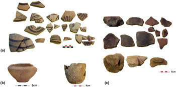
The pottery of the upper layer of fill in trench AZ belongs to the late Middle Cycladic period and includes painted Cycladic White Ware consisting of cups, skyphoi and closed vessels with decoration of wavy lines, spirals, and linear and floral patterns (Fig. 13a); the latter include burnished red bicolour motifs dating to the end of the Middle Cycladic period (Fig. 13a bottom row on the right).Footnote 8 Minoan imports of Middle Minoan white-on-dark ware are also included in the assemblage (sherds from cups decorated in the white-dotted style).Footnote 9 The destruction layer contains a horizon of large- and medium-sized stones mixed with pottery, mainly of the early Middle Cycladic period (Fig. 13b), as well as late Early Cycladic pottery at floor level. In the deeper layers the pottery is coarse, associated exclusively with low-calcareous coarse fabrics (Fig. 13c), both local and imported from Naxos (the rich-in-granite fabric group, Fig. 13c bottom row), belonging to large- and medium-sized red and grey vessels, some burnished, with a large number of vertical strap handles (Fig. 13c upper and bottom rows). In the layers of trench AZ, Early Cycladic II is clearly represented, while the Kastri phase of late Early Cycladic II and Early Cycladic III appears particularly significant.
Representative Early Cycladic and Middle Cycladic pottery from successive layers of trench AZ: (a) upper layer, (b) destruction layer, (c) lower level below the floor.

Trenches Η, Ο and Π on the SE hillside
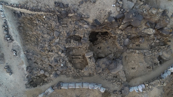
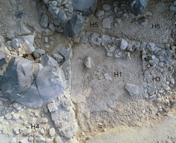
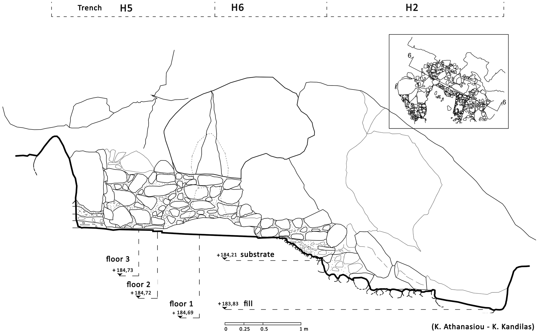
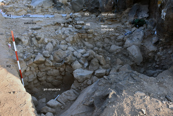
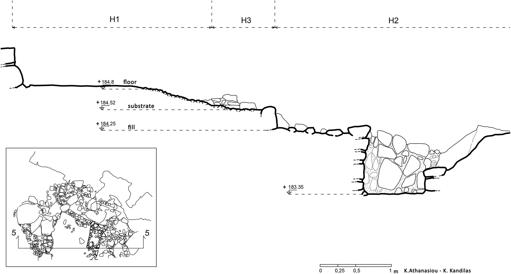
The eastwards continuation of the terrace, on a slightly lower level, is occupied by a building, various spaces of which have come to light (Figs 7 and 9: Η1, H2, H4 and H5/H6). Both the large volcanic rocks to the north and the smaller ones jutting from the surface of the terrace have been incorporated into the structure. A large, fully excavated central space (H1) is clearly delimited by walls on the east, west and north (Fig. 14); the caldera cliff edge prevents the excavation continuing to the south. To the north is a passage between room H1 and the edge of the volcanic rocks (Figs 9 and 14: Η5 and H6), here too faced with a rubble wall (Fig. 15). The floor is of tamped clay. During the removal of the destruction layer in trench H, andesite slabs, probably from the roof, were found among the fallen stones. Inside room H1, two floor phases of tamped clay were found, together with the underlying gravel substrate (Fig. 14). Clay plaster coating is preserved on parts of the north wall of room H1. This wall is in contact with a strong retaining wall to the east of the room (Fig. 14: H3), forming the boundary of the lower terrace (trench H2) to the east. Trench H2 contained an elliptical pit-shaped underground structure, 0.90 m deep, 0.90 m wide and with a preserved length of 1.20 m, faced on the inside with rubble (Fig. 16).
Aerial photograph of the spaces in square H (visible are trenches H1, H3, H4, H5, H6) seen from the south.

Architectural section in the area of trenches H5, H6, H2 (K. Athanasiou and K. Kandilas).

Underground stone pit-shaped structure in trench H2 (bottom left), with room H1 on the upper terrace to the west (upper left). The floor, substrate and underlying fill of the spaces H1, H5 and H6 are visible, together with the andesite roof slabs from the destruction layer (H5/H6, upper right part of photo) (seen from the south-east).

The pottery from the layers of trench H is mostly dated to Early Cycladic II–III. The topmost layer contains characteristic Middle Cycladic pottery of exceptional quality, with Cycladic White Ware, much of it with bichrome decoration. The motifs are mainly spirals and S-shaped ornaments. This layer, 0.10–0.60 cm thick, has probably been significantly eroded, and its association with the building remains on this terrace is unclear. The underlying layers, with a total thickness of 0.50 cm, consist firstly of an upper horizon of stones from the building's destruction layer mixed with Early Cycladic and Middle Cycladic material. There follows the roof collapse layer, with a large number of broken andesite slabs (Fig. 16), placed together with fine gravel and pumice from the Cape Riva eruption which took place before the Minoan eruption (Vougioukalakis Reference Vougioukalakis, Palyvou and Tzachili2015, 25, pl. 1). Pieces of pumice, locally termed ‘adralia’, from the Riva eruption are found in many areas of the excavation as a coating or filling material. Finally, there is the homogeneous Early Cycladic floor layer of tamped clay identified both in room H1 and in space H5 and parts of H6, in at least two successive layers (Fig. 15). The tamped gravel substrate of the floor is also visible. In trench H6 we see the underlying fill of small- and medium-sized stones used to level the terrace (Fig. 16). There is wide scattering of obsidian blades (Syrigou, Reference Syrigouforthcoming). In the same trenches (Η1, H2, Η5) there was a concentration of spinning implements, such as standardised flat discoid spindle-whorls 4–8 cm in diameter and perhaps loomweights. These spindle-whorls, which at Koimisis are relatively grouped together and only of this type, are Early Cycladic II in date. This is one of the earliest types of spinning implement on many Aegean islands (Vakirtzi Reference Vakirtzi2015).
No building remains were found on the lower hillside terraces in trenches Ο and Π (Fig. 6). However, the relatively small area of terrace in trench O on the edge of the cliff contains manmade structures such as a hollow in the rock, in which grain could be crushed (Fig. 8b). The large number of intact limpets (Patella species) and the mass of pottery, its volume exceeding that of the earth in the trench, might mean that this was a dump for pottery and other objects which may have formed a ‘workfloor’, as suggested by the large number of obsidian blades, flakes and a few cores, and also grinders of varying types and sizes. This is very probably the limit of the settlement.
The pottery from this area is mainly Early Cycladic II in date (Fig. 17), as opposed to the Middle Cycladic pottery deposits on the upper terraces of the hill. It includes a large number of sherds from large- and medium-sized pots, many of them burnished, and mostly red and black. The bulk of the pottery comes from local, coarse, dark-coloured vessels with inclusions (Fig. 17f). Bowls, typical of Early Cycladic II, are very numerous. Characteristic Early Cycladic II imported groups are also represented, such as the type with a soapy texture (talc ware) with incised decoration (Fig. 17a) and fine painted ware with dark-on-light decoration with net and other linear patterns (Fig. 17c, d).Footnote 10 There are also sherds from bowl rims with applied rope decoration, imported Urfirnis Ware (Fig. 17b),Footnote 11 fragments of sauceboats, sherds with impressed decoration, and characteristic handles of the period, such as horizontal jar handles with transverse incisions on the back and horizontal tubular handles with vertical incisions from pithoi with conical necks (Fig. 17e).Footnote 12
Characteristic Early Cycladic pottery from the deposit of trench O (pottery drawings by Michaela Zavadil and Barbara Care).

BRIEF COMMENTS ON THE ARCHITECTURE OF THE SETTLEMENT
The settlement is laid out on horizontal levels. In the excavated part of the site there are three main levels of use, following the terrain, with a height difference of around 1–1.5 m (Fig. 18). These levels formed the prehistoric terraces and horizontal levelled areas on which the settlement was built. The buildings of trench Η (floors + 184.7–184.8 m a.s.l.) and trench AZ (highest floor + 185.4 m, lowest floor + 184.7 m) are on the lowest terrace. On the middle terrace stands the ellipsoidal building of trench ΑΒ (floor level + 186.2 m). On the upper level in trench Θ, near the hilltop, is the prehistoric passageway at + 187.8 m.
Architectural plan of the trenches (K. Athanasiou).

As regards the system of circulation, two streets or alleys were identified following the contours of the prehistoric hillside: they run parallel to each other and are oriented north-west to south-east (Fig. 19). The first passageway, in trench Θ (187.8 m a.s.l.), runs north-west to south-east and cuts the steep south-east slope at right angles, the contour lines running north-east to south-west. The terraces on this part of the south-east slope (trench Θ) are at right angles to the passageway, which would either have turned north-east to curve around the terrace or continued along the path between the volcanic rocks, which is still visible today, descending the south-east hillside. The second alley is on the terrace on the south slope, in trench ΑΒ (+186.7 m a.s.l.), and runs west and east along the brow of the prehistoric slope, parallel to the contours of the hillside. It probably continued eastwards, south of trenches Η4 and Η1. No routes of movement at right angles to the two described above have been definitively identified along the south-west slope, joining the two terraces. However, on the west side of the ellipsoidal building AB is a row of stones which may have been placed there to serve as a stepped path leading from the terrace of trench AB up to the highest terrace of the south-east slope (trench Θ). The upper surface of these stones is worn smooth, probably due to constant use, while they have also been placed in a relatively ergonomic pattern, facilitating access from one terrace to the other. On the east hillside, the passageway in the area of trench Θ, following the slope at right angles to the contour lines, ensured communication between the terraces of the south-east slope and up to the top of the hill.
Aerial photograph of the excavation area south and east of the hilltop (seen from the west).

The settlement buildings are oriented according to the terrain and natural features of the landscape, such as rocks (Fig. 18). They are constructed with their walls parallel and at right angles to the contours of the slope. The buildings in trenches AB and H have their corners at north and south, while other buildings, which are currently being excavated (Fig. 6, trench BB) lie more or less at a 45-degree angle, following the brow of the slope, with the sides facing north and south.
The following spaces are observed in the excavation trenches. The building in trench H contains three spaces, two of them roofed and probably indoors, and one outdoors. The spaces are not precisely delimited because some walls are missing (either not excavated or destroyed). The largest room is H1 (Fig. 14), delimited by three walls with the fourth remaining unexcavated at the south end of the trench. The room is trapezoid in shape and measures 2.73 m (north-west to south-east), 3.54 m and 2.45 m (north-east to south-west), covering an area of 8 sq m. The second roofed space (Η5 and Η6) is rectangular and bounded to the north by the rock of the hillside, which had its south surface faced with a rubble wall (Fig. 18) (identified in the spaces of trenches Η5, Η6 and AZ). The east wall has either been destroyed or was absent, making this a semi-outdoor space. The walls measure 3.65 m (north-west to south-east) by 1.65 m (north-east to south-west) with an area of 5.4 sq m. The third, outdoor space (Η2) is bounded by rocks to the north and east and a wall to the west, while the south end is missing (either unexcavated or lost when the south face of the slope collapsed). It measures 3.5 x 1.8 m with an area of 5.8 sq m. A striking feature of this space is the pit-shaped structure to the south, 0.90 m deep and measuring 0.90 x 1.20 m (Figs 16 and 20).
Architectural section in the area of trenches H1, H3 and H2 (K. Athanasiou and K. Kandilas).

In trench AB the ellipsoid apsidal building (Figs 11 and 18), with an open-air space in trench AZ, stands out. The building measures 3.7 x 1.9 m with a total area of 5.85 sq m. A cross-wall divides it into two rooms, one to the north measuring 0.60 x 1.55 m, and one to the south measuring 2.55 x 1.90 m. The building features a doorway 1 m wide with two large jambs, leading to outdoor space AZ. This space is delimited by large rocks on the north and south sides, and by walls to east and west (Figs 18 and 19). The north side is faced with a rubble wall (Fig. 11). The space is almost square, measuring 3.0 x 2.95 m, with an area of 8.7 sq m.
As regards the building techniques, the excavation provided information on the floors, walls, roofs and doorways of the buildings. Floors have been found in almost every room excavated (Fig. 14), while in several cases we have successive floors (Fig. 15), suggesting different phases of continuous habitation. The floors were all constructed in the same way, with three main layers (Fig. 20). The inhabitants first created a level surface on the slope by filling in the hollows and cavities in the rocks and ground with small- and medium-sized rough stones measuring 10–20 cm. A layer of earth with encased small pebbles measuring 4–7 cm followed. The third and final layer consisted of tamped clay, in some cases with fine gravel measuring 1 cm. The final layer is no more than 1–2 cm thick. Where there is more than one floor, as in trenches Η5, Η6 and AZ, we have successive layers of clay and small pebbles.
All the walls of the buildings were made of rubble and clay plaster, now largely lost. Clay plaster was used both as mortar and as wall plaster, the best example being that found on the wall between space H1 and spaces Η5 and Η6 (Fig. 21a). The clay plaster appears to have been processed and contains inclusions of natural inert matter ranging from 0 to 12 mm. The processing would probably have been similar to the traditional method used in the recent past: the clay was prepared and trodden down, wetted to give it consistency and smoothness, and then wetted and beaten again to make it waterproof. Whatever the case, the clay plaster is definitely the product of processing by humans using natural means. The micromorphological study by Myrsini Gouma (Wiener Lab), which included the extraction of undisturbed and oriented samples from the stratigraphic sequences of the excavated trenches, the construction of thin sections and the microscopic analysis of undisturbed soil samples, will shed more light on this matter.
(a) Detail of clay plaster on the wall between H1 and Η5–Η6 and (b) detail of fallen andesite slabs on the floor of H5/H6 (at centre-right, below the large volcanic rock).

The walls served three basic purposes: delimiting and dividing rooms (Fig. 14: wall between space H1 and spaces H5 and H6); forming terraces and retaining walls (Fig. 14: H3); and facing the rough rock surfaces (Figs 11 at upper right and 15). In most cases, the walls had more than one function. Their dimensions and the size of the stones used depended on the function of the wall and its position in the structure. The only walls serving a common purpose were those delimiting the alleys. In the case of the passageway leading to the top of the hill found in trench Θ–ΙΚ, the walls consisted of large volcanic rocks deliberately moved in order to border the alley (Fig. 18). The largest of these rocks measured 0.7 x 1.10 x 0.7 m (height x length x width). The stones of the second alley, in trench AB, were distinctly smaller, averaging 0.3 x 0.45 x 0.4 m. (Fig. 18). These walls could be single or double faced, serving to retain the earth above.
The walls delimited the buildings spatially. The outer walls of the buildings were 0.70 m wide and built of medium to large stones (Fig. 14: wall H1/H4). The interior walls were up to 0.45 m thick and built of smaller stones (Fig. 14: wall H1/H5). Most of the walls were double faced; however, on steeper parts of the slope, sections of the wall were set into the ground to also serve as a retaining wall, as on the north-west side of the ellipsoid apsidal building in trench AB (Fig. 11).
The steepness of the hill on which the settlement was built led to the construction of many terraces and retaining walls, using medium- to large-sized stones. However, where the retaining wall supported another structure, the gap between the outer face of the terrace and the structure was filled with small- to medium-sized stones. A typical example is the south-east outer wall in trench H3 (Figs 7 and 14). The rough surfaces of tall rocks were also incorporated in the retaining walls and faced with stones to create vertical walls (Fig. 11 at upper right). The stones were small- to medium-sized and joined with clay plaster. The walls in trenches Η5–Η6 and AZ are typical examples (Figs 11 at upper right and 15).
Information on the building roofs is provided by the destruction layer inside the buildings, as no roofs have been found in situ. However, large numbers of andesite slabs have been found in destruction layers on the floors, mostly broken due to the frangibility of the material (Fig. 21b). They must originally have been quite large, perhaps measuring over 0.50 x 0.50 m. These slabs were probably laid on top of the roof beams to cover the gaps between them.
The doorways can be divided into two types: those connecting two inner rooms and those leading between an indoor and an outdoor space, the main difference being that the latter had large door jambs (Fig. 18). Jambs have been found in the doorway (1 m wide) connecting the ellipsoid apsidal building AB to the open-air space of trench AZ. Jamb bases were also found at the end of the alley south-west of AB.
CONCLUSIONS
The settlement at Koimisis on Therasia extends across the south and south-east terraces of the Koimisis hill. Before the Minoan eruption it overlooked the wide plain that reached as far as Aspronisi. That plain is now underwater, sunken by the tectonic changes wrought by the volcanic eruptions. The small natural and artificial terraces were the setting for the architectural structures and open-air human activities of the settlement.
The settlement enjoyed a long period of habitation from Early Cycladic II to the end of the Middle Cycladic period. There is some evidence of earlier human presence in Early Cycladic I, but it is not enough to define a distinct phase. The first clear human presence comes in the first phase of Early Cycladic II, with deep bowls and large, coarse storage vessels, associated with the local low-calcareous coarse fabric with volcanic inclusions (Fabric Group A in Kordatzaki et al. Reference Kordatzaki, Sbonias, Farinetti and Tzachili2018, 6–8). This horizon was found in all the trenches and was the exclusive phase in IK, K1 and Θ, and in Μ, Ο and Π. It is also found in the deeper layers of trenches AB and AZ. The next period attested is advanced Early Cycladic IIB–III (Kastri Group), distinguished as a separate phase by the characteristic Kastri type vessels and sauceboat shapes. This is currently identified as the longest-lasting and best-represented period, with which the most important buildings are associated. Imported Talc Ware pottery, widely circulating in the Cyclades during the Early Cycladic I and Early Cycladic II periods, with an origin in the West Cyclades, probably on Siphnos, is documented in a modest frequency in the survey assemblage of the site (Kordatzaki et al. Reference Kordatzaki, Sbonias, Farinetti and Tzachili2018, 10, 13–14) and also in the excavation. This corresponds well with its frequency in Early Cycladic Akrotiri, suggesting direct imports at the site and the participation of the Koimisis settlement in a wide Cycladic pottery network. Pottery from neighbouring islands, particularly Naxos and also Ios, was also intensively consumed at the site (Kordatzaki et al. Reference Kordatzaki, Sbonias, Farinetti and Tzachili2018, 10–15). Other aspects of the material culture, which are still under study, include the obsidian tools (Syrigou, Reference Syrigouforthcoming), the millstones and grinders of various shapes and sizes, and the loomweights. Marble schematic figurines and vases occur rarely. Metal implements, with the exception of a bronze plate, have not been found to date. The evidence of the environmental data from the site is under study. It seems that the inhabitants’ survival, their ‘zoarkeia’ (means of subsistence) as the nineteenth-century Theran physician-philosopher Joseph De Cigalla terms it (Dekigallas Reference Dekigallas1850), was due to their crops and flocks. The large number of intact limpets (Patella species) found in trench O also suggests exploitation of marine resources.
The date and form of the settlement, therefore, place it among similar Aegean settlements, particularly Akrotiri but also Skarkos on Ios (Phase II) and Dhaskalio on Keros, while it adequately proves the presence of these cultural horizons on Therasia, which was connected to Thera during the period under study. The following Middle Cycladic period is attested in the trenches in the south terraces of the hill, AB, AZ and to a lesser extent H, with a concentration of early Middle Cycladic and late Middle Cycladic pottery. This pottery comes from the upper layers of fill in these areas. The transition to the Early Cycladic III–early Middle Cycladic period seems smooth. The destruction levels in trenches AZ and H contained pottery of this phase, suggesting a continuous use of the buildings from the late Early Cycladic II period, with floor deposits in situ, to the Early Cycladic III–early Middle Cycladic period.Footnote 13
The late Middle Cycladic horizon is considerably narrower than the Early Cycladic period, is located in the highest part of the settlement and is found stratigraphically above the Early Cycladic and early Middle Cycladic phases in an apparently smooth sequence. The association of the upper layers containing late Middle Cycladic pottery with the buildings underneath is not always clear in the excavated trenches presented here. Pottery of the late Middle Cycladic period is found on the surface of the paved outdoor space in trench AB, on which was set a large mortar which appears to have been in use in the final phase of the settlement. Buildings of the late Middle Cycladic period with floor deposits in situ, which are currently being investigated at the western end of the south terrace of the hill (Fig. 6: trench BB), show a continuous use of the settlement space throughout the Middle Cycladic period, with a preference for the more even upper terraces of the hill. We should note that no late Middle Cycladic material was found in the steep areas of the east slope (trenches Θ, ΙΚ, Κ1) or on the lower terraces of the hill (O and Π), suggesting a possible contraction of the settlement area in the late Middle Cycladic Period. No occupation of the site after the Middle Cycladic period has been identified to date. There are no traces of Late Cycladic material contemporary with the destruction phase of the settlement, which probably occurred as a consequence of the same destructive event that destroyed the Middle Cycladic town of Akrotiri (Akrotiri IV; cf. Nikolakopoulou Reference Nikolakopoulou2019a, 60).
In conclusion, the first observation to be made concerns the extraordinary organisation and exploitation of the space, and the arrangement of alleys and passageways among the rocks both within the settlement and connecting it to the surrounding region. By means of artificial terraces, sloping paths (perhaps stepped), and passages running among the natural rocks and manmade structures, the inhabitants ascended and descended within the settlement and to and from the plain below, where they accessed their farmland and the sea, and perhaps also open-air workshops. Water would have been available close to the site, as is suggested by the existence of a water source on the upper south-west slopes of the hill, recorded until recently according to the locals but now dried up.
The long lifetime of the settlement, suggested above on the basis of indications of an uninterrupted use of settlement spaces throughout the Early Cycladic II, Early Cycladic III/early Middle Cycladic and late Middle Cycladic periods, shows a balanced way of life, with a long tradition of equitable communal organisation. In modern historical terms, the settlement is characterised by the longue durée. The courte durée, its political and social organisation, is perhaps apparent even in only a glimpse in its overseas relations (Naxos, West Cyclades, Ios, Crete) and, above all, in the changes observed in the archaeological record. Some of these changes led to the contraction of the settlement in the late Middle Cycladic phases (demographics, means of production, lifestyle, intensification of maritime activities centred on the Middle Cycladic town of Akrotiri), and to its complete abandonment. We suppose that habitation shifted to the west, at the settlement site at the Alafouzos Quarry (Fig. 1), to a place resembling that of south Thera around Akrotiri, and perhaps bearing the marks of Minoan influence, as may be deduced from the architectural features of the house excavated by Alafouzos and Fouqué at the Alafouzos Quarry (Tzachili Reference Tzachili2006, 111–45). Although the Koimisis settlement, which shares many characteristics of other proto-urban centres, has not proved up to now to be as large or as important as the towns of the islands of the Eastern Aegean, let alone the Anatolian ones, it can certainly provide us with a great deal of useful information on the conditions and parameters that led to this major change during the Bronze Age.
ACKNOWLEDGEMENTS
We would like to express our thanks to the Institute for Aegean Prehistory (INSTAP), the Municipality of Thera and the General Secretariat for the Aegean and Island Policy (Ministry of Shipping and Island Policy) for their financial support of the ‘Prehistoric Therasia Project’ and the ongoing excavation at Panaghia Koimisis. The ‘Island Cultures in a Diachronic Perspective: The Case of Therasia’ project was cofunded by the European Union (European Social Fund [ESF]) and Greek national funds in the context of the operational program ‘Education and Lifelong Learning’ of the National Strategic Reference Framework (NSRF) 2007–13.