Introduction
The Brazilian state of Mato Grosso is located in the centre of South America, covering c. 900 000 km2 in an ecological tension zone at the transition of three major biomes: Amazon, Cerrado and Pantanal. The Amazon is the largest and most biodiverse tropical forest in the world, playing a critical role in regional and global climate regulation (Oliveira et al. Reference Oliveira, Bottino and Nobre2021, Butt et al. Reference Butt, Baker, Bezerra and Spracklen2023). The Cerrado is the most biodiverse savannah on the planet, being recognized as a biodiversity hotspot that is essential for regional water recharge and for sustaining the Paraguay River, which serves as an international boundary in South America (MMA 2007). The Pantanal is the largest wetland in the world, classified by United Nations Educational, Scientific and Cultural Organization (UNESCO) as a World Natural Heritage site (Libonati et al. Reference Libonati, Dacamara, Peres, Carvalho and Garcia2020).
Yet the main economic activities in the state are agriculture, livestock, logging and hydroelectric power generation, all of which involve intensive use of natural resources and contribute to environmental degradation, threatening regional biodiversity and vital ecosystem functions (Marimon et al. Reference Marimon, Lima, Duarte, Chieregatto and Ratter2006, Libonati et al. Reference Libonati, Dacamara, Peres, Carvalho and Garcia2020, Leite-Filho et al. Reference Leite-Filho, Soares-Filho, Davis, Abrahão and Börner2021, Oliveira et al. Reference Oliveira, Bottino and Nobre2021, Butt et al. Reference Butt, Baker, Bezerra and Spracklen2023). The region’s economic potential is reflected in high annual deforestation rates, which have historically placed the state among the three most deforested in Brazil (INPE 2025).
The Brazilian Federal Law on the Protection of Native Vegetation (Law No. 12,651, 25 May 2012), known as the New Forest Code, establishes general guidelines for the protection of native vegetation and regulates forest exploitation, the supply and traceability of forest products and the prevention and control of forest fires. Its overarching goal is to promote sustainable development by balancing environmental preservation with responsible land use and economic activity (Brazil 2012).
The New Forest Code mandates that rural properties must maintain a legal reserve area (LRA): a certain percentage of the property area for the sustainable economic use of natural resources. The previous Brazilian Forest Code of 1965 (Law No. 4,771, 15 September 1965), with the issuance of Provisional Measure No. 2,166-67 (Brazil 2001), introduced the term ‘legal reserve’, and its concept closely resembles current legal definitions as an area located within a rural property, except for permanent preservation areas, necessary for the sustainable use of natural resources, conservation and rehabilitation of ecological processes, biodiversity conservation and the shelter and protection of native fauna and flora (Brazil 2012).
In the Brazilian Legal Amazon (BLA), a political boundary covering c. 5 million km2 across several states in the Amazon biome, including Mato Grosso State, the LRA percentage varies greatly based on vegetation formation: 80% for forest, 35% for cerrado (i.e., savannah) and 20% for grassland (Brazil 2012). This significant variation in the LRA percentage in Mato Grosso draws interest from rural property owners due to its implications for land-use decisions, as it imposes limitations on alternative land uses that conflict with private property owners’ economic interests
According to the Technical Manual of Brazilian Vegetation (IBGE 2012), forest, cerrado and grassland are distinct vegetation formations with different structural and ecological characteristics. Forests are dense formations dominated by tall trees forming a canopy and exhibiting a complex vertical structure. The cerrado is a savannah-like vegetation structure with scattered small to medium-sized trees and a prominent herbaceous shrub layer. Grasslands, by contrast, are open areas dominated by herbaceous plants and few shrubs, with no trees.
The Environmental Code of Mato Grosso (State Complementary Law No. 38, 21 November 1995) governs the LRA in the state, defining it in Article 62 as ‘forests and other forms of native vegetation representing a minimum percentage of the rural property area, aimed at maintaining its vegetation cover and all existing forms of life’ (Mato Grosso Reference Grosso1995). It is evident that the term ‘forms of vegetation’ emphasizes that the calculation of the LRA percentage is related to vegetation formation (i.e., the physiognomy of vegetation) in state legislation as well.
However, in 2010, changes were made to the Environmental Code of Mato Grosso by Complementary Law No. 382 of 12 January 2010 (Mato Grosso Reference Grosso2010), mandating that LRA determination in Mato Grosso must consider one or more of physiognomy, structure or floristic composition and classify vegetation type as follows: ‘Article 62-B. The classification of vegetal type, at the level of rural property, for the purpose of defining the Legal Reserve, shall be guided by the physiognomy, vegetation structure, and/or floristic composition, according to procedures defined by the regulation and following the following definitions:
I – the following phytophysiognomies shall be considered as forest type: Dense Ombrophilous Forest; Open Ombrophilous Forest; Semideciduous Seasonal Forest and Deciduous Seasonal Forest;
II – the following phytophysiognomies shall be considered as cerrado type: Arborised Campinarana; Graminoid-Woody Campinarana; Arborised Savanna; Savanna Park; Graminoid-Woody Savanna; Arborised Steppe Savanna; Steppe Savanna Park; Graminoid-Woody Steppe Savanna; Forested Campinarana; Forested Savanna and Forested Steppe Savanna.’
In addition, according to the Environmental Code of Mato Grosso, vegetation classification must refer to the vegetation map created by the Brazilian Ministry of Mines and Energy in the 1970s through the RADAMBRASIL Project (Radar in the Amazon; IBGE 2018). The project’s objective was to develop thematic maps of natural resources over an area of 1.5 million km2 in the northern, north-western and central-western regions of the country (IBGE 2018), including vegetation-type maps using radar sensors at regional scales (1:1 000 000 and 1:250 000; Veloso & Góes-Filho Reference Veloso and Góes-Filho1982).
Furthermore, the amendment made to §2 of Article 62 by Complementary Law No. 382 of 12 January 2010 (Mato Grosso Reference Grosso2010) created the possibility of conducting technical studies on rural properties when there is a disagreement regarding the existing vegetation type compared to the RADAMBRASIL vegetation map at a scale of 1:1 000 000. These studies have resulted in a ‘Technical Report for the Identification of Vegetation Type’, which requires approval by the Secretaria de Meio Ambiente do Estado de Mato Grosso (SEMA; State Environmental Agency). It is noteworthy that a classification of ‘vegetation type’ emerged that involves identifying the floristic composition and not just the vegetation formation (Tart et al. Reference Tart, Williams, Brewer, Dibenedetto and Schwind2005, Box & Fujiwara Reference Box, Fujiwara, van der Maarel and Franklin2013, IAVS 2023) as defined by the federal legislation.
In this sense, vegetation classification is crucial in the state of Mato Grosso because of the presence of three major biomes (Amazon, Cerrado and Pantanal) that form a mosaic of diverse vegetation formations and their contacts, each carrying different percentages for LRA determination. The changes in state legislation modified the application of federal law, requiring not only vegetation formation to be considered but also species composition when defining the percentage of LRA on rural properties, thereby rendering this task more complex.
In accordance with the distribution of legislative powers in Brazil among federative entities, both the Union and the states share concurrent jurisdiction to legislate on forests, nature conservation, soil preservation, natural resources and environmental protection (Trennepohl Reference Trennepohl2020). While the Union is responsible for establishing general norms, the states have supplementary competence, and their norms must not contradict general norms, ensuring the harmonious exercise of this legislative competence (Brazil 2021).
However, we hypothesize that the state legislation on the classification of vegetation is increasing the potential for clear-cut deforestation in areas that should be designated as LRA by federal law. The aim of this paper is to demonstrate that the Brazilian Federal Law on the Protection of Native Vegetation considers vegetation formations in the definition of the LRA and not vegetation types. It also seeks to highlight how changes in the Environmental Code of Mato Grosso have led to a reduction in LRA, in contradiction to federal law. Additionally, by relying on official maps of vegetation types, we estimated the extent to which forest-formation areas in the state of Mato Grosso (Fig. 1) could be inaccurately classified as cerrado formations and the potential for further deforestation based on Mato Grosso’s legislation.
Location of the state of Mato Grosso (Brazil), Brazilian Legal Amazon (BLA) and Brazilian biomes in South America.

Methods
Classification of vegetation for the definition of the percentage of legal reserve area based on federal law
The BLA includes parts of the Amazon, Cerrado and Pantanal biomes, indicating that the terms ‘forest’, ‘cerrado’ and ‘grassland’ formations do not align with the standard biome nomenclatures. The difference in the terms ‘biome’ and ‘formation’ (Table S1) lie in the former considering the entire biota of an area (fauna and flora; IBGE Reference de Geociências2004, Coutinho Reference Coutinho2006, Batalha Reference Batalha2011, Box & Fujiwara Reference Box, Fujiwara, van der Maarel and Franklin2013, Mucina Reference Mucina2019), not just the appearance (physiognomy) of vegetation (Coutinho Reference Coutinho2006, IBGE 2012, Box & Fujiwara Reference Box, Fujiwara, van der Maarel and Franklin2013, Mucina Reference Mucina2019, IAVS 2023).
In contrast, the term ‘vegetation type’ encompasses not only the flora (including species composition) but also other aspects of the environment (Eiten Reference Eiten1979). Its classification depends on the predominance or proportion of different life forms in the vegetation, considering factors such as density, leaf fall seasonality, species and other characteristics influenced by determinants such as climate, soil, geomorphology and fire (Tart et al. Reference Tart, Williams, Brewer, Dibenedetto and Schwind2005, Coutinho Reference Coutinho2006, Ribeiro & Walter Reference Ribeiro and Walter2008, Box & Fujiwara Reference Box, Fujiwara, van der Maarel and Franklin2013). Thus, it is understood that various vegetation types exhibiting similar formations may coexist within the same biome but are differentiated through the assessment of a broader set of characteristics primarily dictated by the species within the vegetation community – for example, both Seasonal Semideciduous Forests and Forested Savanna vegetation types in the Cerrado biome exhibit forest formations but differ in their floristic composition due environmental conditions and biological interactions (Martins Reference Martins2012).
In addition, the etymology of the term ‘phytophysiognomies’ used in Mato Grosso’s legislation suggests a focus on the appearance of plants and is more aligned with the concept of ‘vegetation formation’ than with ‘vegetation type’. Moreover, federal law always refers to ‘forests and other forms of vegetation’, emphasizing that the criterion for defining LRA on rural properties is the vegetation formation characterized as forest, cerrado or grassland.
‘Forest’ represents the largest vegetation formation, possessing the highest conservation guarantee owing to the requirement of 80% of the rural property area as an LRA in the BLA. A forest is defined as an area predominantly featuring arboreal species where a continuous or discontinuous canopy is formed (MMA 2007, Martins Reference Martins2012). However, according to the Technical Manual of Brazilian Vegetation (IBGE 2012), the scientific concept establishes that a forest is a set of synusiae dominated by large phanerophytes (trees), with well-defined strata (herbaceous, shrubby, treelet/low arboreal and arboreal), where height is also included as a parameter to differentiate it from other woody formations.
The ‘cerrado’ is the formation that raises most confusion for classification due to the existence of various meanings of the term, causing errors in the delimitation of the LRA due to the lack of uniformity in its use throughout history (MMA 2007). The relevance of these concepts for LRA lies in the common, broad classification in the scientific literature of ‘cerrado sensu lato’ into three formations: forest, savannah and grassland (Goodland Reference Goodland1971, Joly et al. Reference Joly, Aidar, Klink, McGrath, Moreira and Moutinho1999, Coutinho Reference Coutinho2006, MMA 2007, Ribeiro & Walter Reference Ribeiro and Walter2008, IBGE 2012). Therefore, it is important to understand what ‘cerrado’ concept the federal legislation adopts.
The term ‘cerrado’ is used in three senses: (1) when referring to the Cerrado biome (written with an upper-case initial letter), encompassing all existing vegetation types and faunistic composition in the region; (2) when referring to the ‘cerrado sensu lato’, which relates to vegetation types defined by floristic composition and the Cerrado biome’s physiognomies, including everything from forest to grassland formations, except gallery forests, dry forests and riparian forests (this meaning is similar to Cerrado but specifically refers only to the vegetation); and (3) when referring to the predominant vegetation type in the Cerrado biome, the ‘cerrado sensu stricto’, including typical cerrado, rocky cerrado and open cerrado, among others (Oliveira-Filho & Ratter Reference Oliveira-Filho, Ratter, Oliveira and Marquis2002, MMA 2007, Batalha Reference Batalha2011).
The ‘cerrado sensu stricto’ is a vegetation type characterized by medium- or small-sized trees distributed randomly in the terrain without forming continuous canopy and coexisting with a herbaceous shrub stratum (Ribeiro & Walter Reference Ribeiro and Walter2008). These characteristics are the same as those described for the vegetation class known as ‘savannah’ (IBGE 2012, Martins Reference Martins2012), therefore rendering them synonymous. Thus, considering that the other concepts applied to ‘cerrado’ also include forest and grassland formations in their definitions, the ‘cerrado sensu stricto’ must be the concept used to classify the cerrado formation based on federal law and the scientific literature.
The grassland is undoubtedly a vegetation formation that causes less controversy because the term is universally used to designate areas predominantly occupied by herbaceous species and some shrubs, with the absence of trees in the landscape (MMA 2007, Ribeiro & Walter Reference Ribeiro and Walter2008, IBGE 2012).
Table 1 presents the terms included in both federal and state legislation for defining the LRA, as well as the concepts applied according to the former.
Summary of the concepts adopted based on the scientific literature for the definition of the legal reserve area (LRA) under federal legislation.

Calculation of the impact of deforestation in the state of Mato Grosso through amending the classification of vegetation in state law
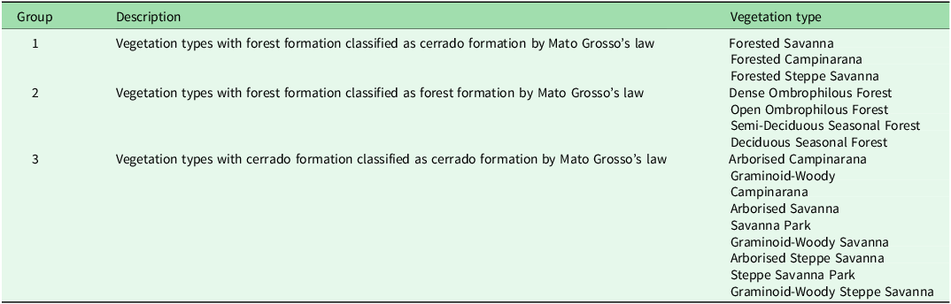
The map of Brazil’s vegetation types created by the Brazilian Institute of Geography and Statistics (IBGE 2021) was adopted as a reference to assess potential areas that may be deforested in non-compliance with Brazil’s federal legislation but with authorization from the Government of Mato Grosso. This map (IBGE 2021) is based on the Technical Manual of Brazilian Vegetation (IBGE 2012) and the RADAMBRASIL vegetation-type map (Veloso & Góes-Filho Reference Veloso and Góes-Filho1982) at a scale of 1:250 000, which is available on the institution’s official website and includes metadata in Portuguese. We defined the predominant vegetation types in an area according to the map’s ‘nm_uveg’ attribute. Then, group areas related to the vegetation types outlined in the Environmental Code of Mato Grosso (Article 62-B; Mato Grosso Reference Grosso1995) were extracted (Table 2).
Grouping areas related to the vegetation types outlined in the Environmental Code of Mato Grosso (Article 62-B; Mato Grosso Reference Grosso1995) according to vegetation formation.

Subsequently, we exclude public ownership areas in Conservation Units (CUs), and Indigenous Territories (ITs) in the state of Mato Grosso because deforestation could not be authorized in these areas according to Articles 13-A and 17 of State Decree No. 1,031 (Mato Grosso Reference Grosso2017). The maps of the CUs and ITs were obtained from the official website (SEMA 2023).
Finally, we intersected the information extracted from the IBGE (2021) vegetation-type map with the vegetation-formation map used as a reference by SEMA to define vegetation classes based on the ‘FITOECOLOG’ attribute, which determines whether a specific area is forest or cerrado vegetation formation. This map, titled RADAMBRASIL, was obtained from the official SEMA website (SEMA 2023). The metadata for the vegetation-formation map are not publicly available, making it impossible to detail its elaboration; however, the attribute table indicated a scale of 1:1 000 000.
Then, we measured: (1) the area of Group 1 extracted from the IBGE (2021) vegetation-type map overlaid on the SEMA (2023) map to calculate the area of forest vegetation types that are defined as cerrado formations in the legislation of Mato Grosso; (2) the area of Group 2 overlaid on cerrado areas in the SEMA (2023) reference map; and (3) the areas of Group 3 located in forest areas on the SEMA (2023) map, which can be classified as cerrado if requested to SEMA by the rural property owner. Considering that there is no classification of grassland in Mato Grosso state law or in the SEMA (2023) map, this vegetation formation was not considered in the analysis.
The SEMA (2023) and IBGE (2021) vegetation maps were compared because they were constructed based on the RADAMBRASIL Project (Veloso & Góes-Filho Reference Veloso and Góes-Filho1982), aligning with the provisions of the Environmental Code of Mato Grosso for use as a reference. We considered the IBGE (2021) vegetation map to be more representative of reality due to its greater level of detail compared to the SEMA (2023) vegetation map (map scales of 1:250 000 rather than 1:1 000 000, respectively).
We performed the processing and analysis of vector maps using ArcMap 10.1 software (Esri), employing tools such as Select By Attributes, Create Layer From Selected Features, Erase and Intersect. The maps were processed using the SIRGAS 2000 data and projected using the Albers Equal-Area Conic projection system for area calculations. All original and newly created maps used in this study are available in Appendix S1.
Results
A comparison between the SEMA (2023) vegetation-formation map and the IBGE (2021) vegetation-type map (Fig. 2) revealed that 2 074 400 ha of Forested Savanna, Forested Campinarana and Forested Steppe Savanna are already defined as cerrado formations according to the SEMA (2023) map (Fig. 2a), although they exhibit a forest formation. In addition, 1 246 924 ha of these vegetation types classified as forest on the SEMA (2023) map can be redefined to cerrado through a request submitted to SEMA by the rural property owner, along with a Technical Report for the Identification of Vegetation Type (Fig. 2a). Furthermore, 2 498 870 ha of vegetation types defined as forest formations by Mato Grosso legislation are defined as cerrado formations on the SEMA (2023) vegetation-formation map (Fig. 2b), and 3 224 871 ha of cerrado vegetation types in the IBGE (2021) map are classified as forest formations in the SEMA (2023) map (Fig. 2c) but can also be redefined through a formal request to SEMA. Thus, we estimated that 9 045 065 ha may have LRA percentages altered from 80% to 35% (Fig. 2d), resulting in a total of 4 070 279 ha (1 118 966 ha in the Amazon, 2 370 335 ha in the Cerrado and 580 978 ha in the Pantanal) potentially having undergone deforestation authorized by the state of Mato Grosso in non-compliance with federal legislation under the pretext that these are not forests but rather cerrado formations.
Potential pseudo-legal deforestation maps due to changes in the classification of native vegetation in Mato Grosso, Brazil (mapped at a scale of 1:250 000). (a) IBGE (2021) map of forest formations (FC = Forested Campinarana; FS = Forested Savanna; FSS = Forested Steppe Savanna) defined as cerrado formations by the Environmental Code of Mato Grosso (ECMT) and on the SEMA (2023) vegetation-formation map. (b) IBGE (2021) vegetation-type map defined as forest formations by the ECMT but mapped as cerrado formations on the SEMA vegetation-formation map. (c) IBGE (2021) vegetation-type map defined as cerrado formations by the ECMT but mapped as forest formations on the SEMA (2023) vegetation-formations map. (d) Areas where the legal reserve area (LRA) may be reduced from 80% to 35% through the application of the legislation of the state of Mato Grosso. Sources: SEMA (https://geoportal.sema.mt.gov.br/) and IBGE (https://www.ibge.gov.br/geociencias/informacoes-ambientais/vegetacao.html). CU = Conservation Unit; IT = Indigenous Territory.

Discussion
We show that differences in vegetation categorization between the Federal and Mato Grosso state laws allowed deforestation for alternative land uses at a greater percentage than that defined by federal legislation.
In addition, the use of reference vegetation maps at less detailed scales by SEMA (1:1 000 000; SEMA 2023), despite the existence of official maps with greater detail from the RADAMBRASIL Project (Veloso & Góes-Filho Reference Veloso and Góes-Filho1982), such as the vegetation map at a 1:250 000 scale (IBGE 2021), increased the uncertainty in LRA percentage determination. It is important to note that because both maps were constructed based on the RADAMBRASIL vegetation map, there is no need to alter the state legislation of Mato Grosso to replace one with the other, as the use of the RADAMBRASIL vegetation map is already provided for in the Environmental Code of Mato Grosso.
Furthermore, with modifications in state legislation, SEMA requires studies and surveys that are not required by federal law for determining the vegetation class for the LRA definition in federal legislation. Additionally, field procedures, which involve vegetation sampling and tree species identification (Mato Grosso Reference Grosso2010b, Reference Grosso2021), add complexity to these studies. The intricacy of these studies stems from the presence of over 2000 tree species in the state of Mato Grosso (Borges et al. Reference Borges, Silveira and Vendramin2014), necessitating identification based on reproductive structures that emerge at different times depending on the species. Moreover, certain vegetation types, such as riparian forests, dry forests (Seasonal Forests) and even Forested Savannas, demonstrate nearly imperceptible transitions via a continuum of gradual vegetation changes rather than discrete boundaries (Marimon et al. Reference Marimon, Lima, Duarte, Chieregatto and Ratter2006, MMA 2007, Martins Reference Martins2012). This increases the risk of misclassification and validation errors by SEMA, potentially leading to forested areas, such as Seasonal Forests, being classified as cerrado areas if they are confused with Forested Savannas. However, at present, we are unable to determine precisely how many hectares of forest have been reclassified as cerrado since the amendment of the law in 2010, as these areas are not disclosed by SEMA.
Concerns regarding calculating the LRA in the state of Mato Grosso are not new. A study conducted in 2009 by the Legislative Consultancy of the National Congress (Ganem Reference Ganem2009) addressed the conflicts that arose between SEMA and the Brazilian Institute of Environment and Renewable Natural Resources (IBAMA) in environmental licensing processes for rural properties located in transition areas. During this period, the LRA defined by state legislation was 50% in these areas. Ganem (Reference Ganem2009) investigated vegetation classification and concluded that vegetation formation is the criterion adopted in federal legislation for computing LRA.
The Federal Constitution of Brazil (Brazil 1988) established a model of shared legislative authority in environmental matters, whereby the Union is responsible for enacting general rules (Article 24, §1), while the states are tasked with supplementing these rules (Article 24, §2) or exercising full legislative power in the absence of federal regulation (Article 24, §3). However, this interpretative openness led to federal conflicts when states exceed constitutional boundaries by enacting provisions that not only supplemented but directly conflicted with the guidelines established by the Union (Brazil 2018a, 2018b, 2018c, 2021).
In 2015, Brazil signed the Paris Agreement along with more than 195 other nations at the UN Climate Change Conference (COP21) and committed to taking action to conserve and enhance carbon sinks, reduce emissions from deforestation and forest degradation and promote the conservation and sustainable management of forests and enhancement of forest carbon stocks (UN 2015). Thus, while the Federal Government of Brazil and the international community have adopted strategies to curb deforestation in the last decade (Silva-Júnior et al. Reference Silva-Júnior, Pessôa, Carvalho, Reis, Anderson and Aragão2021), the state of Mato Grosso has made changes to its legislation to allow deforestation authorizations that deviate from federal law.
It is worth emphasizing that studies have demonstrated how deforestation in the Amazon and Cerrado can impact rainfall patterns, leading to predictions of more intense droughts in the region, causing disruptions to globally significant agricultural production (Leite-Filho et al. Reference Leite-Filho, Soares-Filho, Davis, Abrahão and Börner2021). Furthermore, deforestation may contribute to increased temperatures, jeopardizing biodiversity, the economy and human health (Oliveira et al. Reference Oliveira, Bottino and Nobre2021, Bennett et al. Reference Bennett, de Sousa, Monteagudo-Mendoza, Esquivel-Muelbert, Morandi and de Souza2023, Butt et al. Reference Butt, Baker, Bezerra and Spracklen2023, Aguirre-Gutiérrez et al. Reference Aguirre-Gutiérrez, Díaz, Rifai, Corral-Rivas, Nava-Miranda and González-M2025). Moreover, these impacts are not confined to the Amazon and Cerrado regions; they may extend to other areas, such as the Pantanal, where the significant fires recorded in 2020 were associated with regional climate changes (Libonati et al. Reference Libonati, Dacamara, Peres, Carvalho and Garcia2020). Thus, these changes pose significant risks to biodiversity conservation and sustainable development in regions where vegetation exhibits low resilience and poor recovery (Hirota et al. Reference Hirota, Holmgren, Van Nes and Scheffer2011, Boulton et al. Reference Boulton, Lenton and Boers2022).
Our study demonstrates that issues related to the concepts, classifications, methods and mapping scale for delimiting native vegetation have significant implications for biodiversity conservation and climate regulation through legal protection. In the case of state of Mato Grosso, we emphasize that harmonizing vegetation terminology and using high-resolution maps are both scientifically and legally urgent. Simple actions, such as aligning concepts in state legislation with federal laws and using reference maps with a more detailed scale, can prevent new deforestation of c. 5 million ha in biomes with high biodiversity that are of extreme importance for regional climate regulation.
Supplementary material
For supplementary material accompanying this paper, visit https://doi.org/10.1017/S037689292510012X.
Acknowledgements
We thank the editor, associate editor and reviewers for their careful evaluation and constructive contributions to the improvement of this manuscript.
Financial support
This research received no specific grant from any funding agency in the public, commercial or not-for-profit sectors.
Competing interests
The authors declare none.
Ethical standards
Not applicable.