

Introduction
Land resources are limited, and therefore, there is an urgent need to optimize land use in the most practicable and logical way to continue sustainable production while conserving fragile ecosystems1, Reference Moody, Cong, Legrand and Chon2. Jordan is generally dominated by an arid to semi-arid climate and characterized by dry, hot summers and mild, wet winters with extreme variability in rainfallReference Hatten, Taimeh, Taimeh and Hattar3. Limited natural resources in combination with a growing populationReference Dengiz, Bayramin and Yuksel4 necessitate the improvement of agricultural productivity. To achieve this, appropriate and sustainable land-use schemes are required. The first step in their development is the evaluation of the biophysical land resources. Crop-land suitability analysis is a pre-requisite to achieving sustainable utilization of available land resources and mitigating land degradationReference D'Angelo, Enne, Madrau, Percich, Previtali, Pulina and Zucca5, Reference Nisar Ahamed, Gopal Rao and Murthy6.
The FAO framework7 is an approach for land suitability evaluation, which classifies land in terms of suitability ratings from highly suitable to not suitable based on soil, climate and terrain propertiesReference Nisar Ahamed, Gopal Rao and Murthy6, Reference Melitz8. The approach starts by identifying relevant land-use types, which includes levels of know-how, available technology and available inputs and also the land tenure situation, to indicate the degree to which the land user can manage or overcome constraining land qualities. However, in most cases, land evaluation includes little information about adopted farmers' practices that are specific to the area under consideration, which results in a mismatch between land suitability and current land use.
Many factors determine the accuracy of the results from such land suitability evaluation. Among these are the selection of land characteristics that are most limiting for the specified land uses, as well as the ratings given to each of the land characteristics. In most cases, the limiting land characteristics are chosen and their ratings are defined based on results from other similar areas or using expert knowledge. Hence, there is the uncertainty of the limiting land characteristics chosen and the uncertainty of their ratings. Adaptation of land-use requirements to local varieties, management techniques and environmental conditions is often neglected, resulting in land suitability classifications of low reliability. This raises questions about the reliability of the final suitability map and its use in land-use planningReference Messing and Hoang Fagerström9.
Land suitability evaluation is widely used by many projects and researchesReference Hatten, Taimeh, Taimeh and Hattar3, 10–Reference Ziadat14. However, the results of land evaluation are used as inputs for land-use planning exercises without comparing these results with the current land-use pattern, and without taking the farmer's knowledge into consideration. Comparison of the current land-use map, which also reflects the farmer's indigenous knowledge, with the suitability maps is useful to identify differences or similarities between the present land use and the potential suitability of an area for proposed land utilization types (LUTs)Reference Ceballos-Silva and López-Blanco15, Reference Ziadat and Al-Bakri16. This is simply because farmers have farmed their region long enough to know which sites are suited for particular uses and how to adapt to limitations imposed by the prevailing ecosystemReference Ryder17, Reference Ziadat, Hattar and Baqain18.
Farmers and land resource professionals assess the options that optimize the productivity and sustainability through different knowledge systems. Both systems have advantages and drawbacksReference Cools, De Pauw and Deckers19, Reference Beckford and Barker20. The use of conventional soil survey information in traditional rural societies frequently fails because it does not take into account soil knowledge and experience of local peopleReference Barrera-Bassols, Zinck and Van Ranst21. Merging technical and local thinking is indispensable to formulate sustainable land management schemesReference Ziadat, Hattar and Baqain18, Reference Barrera-Bassols, Zinck and Van Ranst22, Reference Gruver and Weil23. Agricultural land suitability classification based on indigenous knowledge is vital to select and put into practice sustainable land uses1, Reference Pulido and Bocco24–Reference Mairura, Mugendi, Mwanje, Ramisch, Mbugua and Chianu27.
Adaptation of land use to the potentials and constraints of the agro-ecosystem is a key principle of sustainable land managementReference Moody, Cong, Legrand and Chon2, Reference Cools, De Pauw and Deckers19. Therefore, it is not only the biophysical factors (e.g., soil, climate or parcels of land) that are important, information representing the people involved in the planning process is also of critical importanceReference Bojórquez-Tapia, Díaz-Mondragón and Ezcurra28–Reference Ahnström, Höckert, Bergeå, Francis, Skelton and Hallgren30. Therefore, it is important to verify the land suitability evaluation results, for which the consideration of current land use and farmers' knowledge are of great valueReference Ryder17.
The objectives of this study were to compare the current land use with land suitability, and to modify the land suitability evaluation process according to field verifications and farmers' adopted technologies and knowledge.
Methodology
Study area
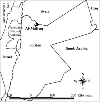
The study area is located in the north of Jordan between the latitudes 32°22′ and 32°45′ north and longitudes 36°22′ and 36°45′ east, and covers an area of 148 km2 (Fig. 1). Most of the area is formed from old colluvial material dominated by Calcids with inclusions of Cambids soils31. Generally, it is a very gently undulating lava plain with dominant slopes between 1 and 4% at an altitude of 650–750 m above sea level. Most of the soils have a transitional xeric–aridic moisture regime and thermic temperature regime31. The mean annual precipitation is 175 mm. The average annual temperature is 16.5°C, the mean daily minimum temperature is 9.2°C and the maximum temperature is 23.9°C. The mean relative humidity is 56%32.
Location of Al-Mafraq study area within Jordan.

Land suitability evaluation
The land suitability was evaluated based on the FAO framework for land evaluation7. LUTs were selected taking into account previous research in the study area in particular and in Jordan in generalReference Hatten, Taimeh, Taimeh and Hattar3, 10, Reference Mazahreh11, Reference Ziadat14, Reference Ziadat and Al-Bakri16. An important assumption was that the low rainfall in the study area could not sustain rain-fed agricultureReference Hatten, Taimeh, Taimeh and Hattar3, 10. However, rain-fed agriculture is still practiced in the study area, because farmers expect 1 out of 3 years to have some rainfall for marginal production. The general prevailing land-use pattern in the study area was also considered in the selection process. The following LUTs were selected: open range, improved range by using small pits for water harvesting; rain-fed barley for livestock grazing; drip-irrigated vegetables; and drip-irrigated trees.
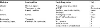
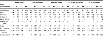
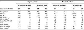
Land qualities were selected and the rating of criteria for land suitability classification were derived and modified based on previous researchReference Hatten, Taimeh, Taimeh and Hattar3, 10, Reference Mazahreh11, Reference Rashdan13, Reference Ziadat and Al-Bakri16. A major consideration in the selection of land qualities is their expected effect on the use and management of land for the selected LUTs. The National Soil Map and Land Use Project (NSMLUP)10 and Jordan Arid Zone Productivity Project (JAZPP)Reference Hatten, Taimeh, Taimeh and Hattar3 aggregated the required land qualities and their characteristics into five main groupings: Climate, Soil, Erosion, Topography and Rock outcrop/stones. Table 1 summarizes the selected land-use limitations, the land qualities and land characteristics used to account for the effect of each limitation. Table 2 shows the land-use requirements in terms of land qualities and land characteristics for each of the selected land-use types. These are the requirements that are usually considered by conventional land suitability analyses, i.e., without thorough considerations of farmers' adopted practices that are specific to a particular area. In this research, land suitability was done using these ‘original’ land-use requirements and were then adjusted according to farmers’ adopted practices.
Land-use limitations, land qualities and land characteristics.

1 WGPT: summation of degrees greater than 8°C during the coldest months (December, January and February).
Land-use requirements for different LUTs.

Source: MoA10, MazahrehReference Mazahreh11 and Hatten and TaimehReference Hatten, Taimeh, Taimeh and Hattar3.
1 Suitability classes: S1, highly suitable; S2, moderately suitable; S3, marginally suitable; NS, not suitable.
2 NL, not limiting.
3 WGPT, winter growth potential (summation of degrees >8°C during the coldest months).
4 AWHC, available water-holding capacity.
5 Erosion class: 1=nil, 2=slight, 3=moderate, 4=severe.
6 Stone content in the surface horizon.
The main source of information for this land suitability analysis was derived from NSMLUP10. The data exist as original paper maps (scale 1:10,000), tables and digitized information entered into the Jordan Soil and Climate Information System (JOSCIS) database. The relevant data in this database are the 2193 soil observations (pits and auger holes) collected during the soil survey. The land-use requirements (Table 2) determine the required factors for land suitability analysis. These factors are: rainfall, temperature, soil depth, available water-holding capacity, slope, surface stoniness, erosion type and class, surface cover type (stones, boulders, rock outcrop) and percentage of surface cover.
The evaluation procedure was based on the simple limitation system. This implies that suitability classes, namely highly suitable (S1), moderately suitable (S2), marginally suitable (S3) and not suitable (NS), were defined based on the most severe limitation(s)Reference Dent and Young33. To undertake this classification, land characteristics derived from soil observations were matched with the crop requirements listed in Table 2 to assign a land suitability class for each soil observation; the so-called matching process. Spatial interpolation between observations was then used to generate suitability maps for different LUTs (to create a continuous surface that covers the whole study area). Since the interpolated variable is ordinal, Thiessen polygons, exact interpolators of nearest neighborhood, were used for this interpolation. This procedure is known as proximity analysis, which assigns the suitability rating of an observation point to the closest area to that pointReference Burrough and McDonnell34.
Mapping of current land use
A Landsat Enhanced Thematic Mapper (ETM+) image was used to map the current land use. The spatial (15 m) and spectral resolutions (eight bands) of the ETM+ images are important characteristics for land-use mapping. Both ERDAS imagine 8.4 and ArcView GIS software were used to derive the land-use map. The ETM+ image was geometrically corrected using geo-coded image of SPOT PAN digitally merged with Landsat TM and originally used by the NSMLUP10. Visual interpretation of false color composites of ETM+ Bands 2, 3 and 4 was performed through the digitizing process. The identity of each class was determined through field visits during which the location of 45 randomly selected fields was recorded by Global Positioning System (GPS). The visited fields represent the different land-use classes in the study area, being rangeland, field crops, vegetables, trees and urban areas.
Comparison between potential and current land use
The agreement between potential and current land uses was assessed by overlaying the suitability maps with current land-use map. The purpose of this comparison was to determine areas where the current land use is different from potential land use, i.e., areas where land suitability evaluation results indicated that the land is marginally suitable or not suitable for the type of land use for which it is currently used. In other words, good agreement was given for lands that are classified as highly or moderately suitable for trees and currently cultivated with trees. Marginally suitable land was considered under disagreement category because it might be highly or moderately suitable for another use and the farmer is losing opportunity to improve productivity (yield gap between current and potential use). The farms that show strong limitation to their current use (marginally suitable or not suitable) were identified. Sixteen farms were selected to represent different combinations of suitability classes and current land use and were visited to explore the farmers' improved management practices adopted to overcome these limitations.
Field visits
Of the 50 farms that were located within the study area, 16 farms were visited during four field visits. These farms were selected to represent cases where the land evaluation indicated that the farm is not suitable for certain land use and at the same time the farmer is using the land for that use. The semi-structured interview technique was used to interview 25 farmers who own and/or cultivate the land of the selected farms, having no set of questions or questionnaires. Instead, the interviewer used a checklist of topics for the discussions which were decided in advance. The topics of the checklist include information about land-use type, the dominant limiting factors for the actual land use, the management practices that are adopted by farmers to overcome the limiting factor(s) in the land and to improve productivity, the farmers’ assessment of productivity (quantity and trend) of the actual land use and the economic benefits from cultivating the land for that land use.
The discussions could evolve freely, and more questions could arise and be asked as others were being answered, without risking the interview losing its structureReference Townsley35, 36. This also gives farmers more opportunities to add new points that were not accounted for by researchers. The interviews with farmers concentrated on specific management practices to overcome land-use limitations.
Revised land suitability evaluation
Land evaluation results were revised based on modified rating of land-use limitations and land qualities. This modification takes into consideration the existing land-use pattern and incorporates the farmers' improved management, according to the following steps:
1. The values for each land characteristic were derived from soil observations located within the selected farms (derived from the 2193 soil observations), and each farm contained many soil observations. The weighted average, based on the area of the farm, of these land characteristics for the selected farms was calculated. These average values were considered as the modified value for which the specified land-use type can be implemented successfully (modified criteria). The farmers indicated comparable management practices among these farms and indicated satisfactory yield.
2. Based on these averages, the ratings of land characteristics were modified. The higher value of weighted average was considered as criterion ranking of highly suitable class and the lower value was considered as criterion ranking for marginally suitable class. For example, the lower limit of soil depth for irrigated trees was 150 cm based on criteria suggested by researchers (Table 2), while the average maximum soil depth under successful cultivation of irrigated trees was calculated to be 103 cm. Therefore, 103 cm was considered as the lower limit for successful cultivation (highly suitable) of irrigated trees using the farmers' management practices.
3. The whole land suitability evaluation process was repeated to take into consideration the modified ratings of land qualities based on field visits and farmers' knowledge.
Results and Discussion
Land suitability
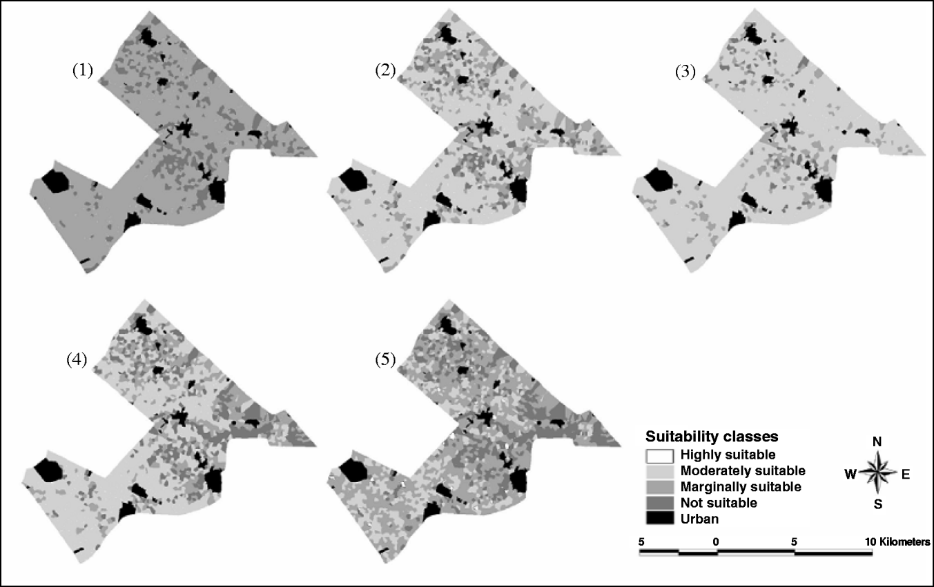
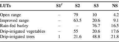
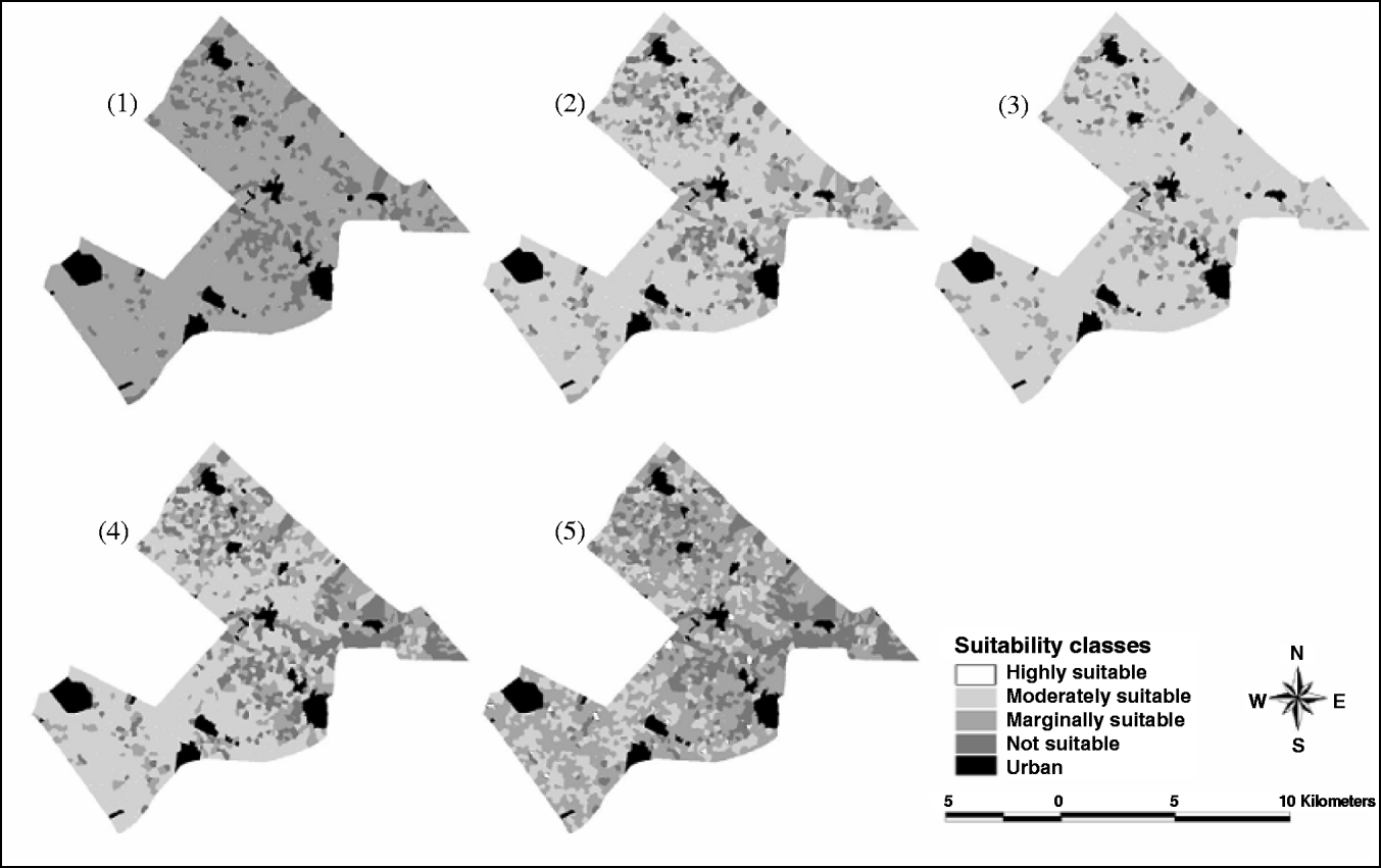
The results based on applying the original land-use requirements show that no land was classified as highly suitable (S1) for open-range, improved-range or irrigated vegetables (Table 3 and Fig. 2). This is because the winter growth potential temperature (WGPT) criterion for S1 is 400 degree-days, and the maximum WGPT in the study area was 387 degree-days (Table 4). No land was classified as highly suitable or moderately suitable for rain-fed barley. This is because the precipitation requirement to classify land to S1 is 250 mm and to S2 is 200 mm, which is higher than the average annual precipitation in the study area (175 mm). A large part of the study area is potentially not suitable for drip-irrigated trees, mainly due to shallow soil depth dominating the study area and high coverage of stones at the soil surface.
Potential land suitability for (1) rain-fed barley; (2) improved range; (3) open range; (4) drip-irrigated vegetables; and (5) drip-irrigated trees.
Area of each suitability class for each LUT as a percentage of the study area (urban area occupies 6.8% of the total area).
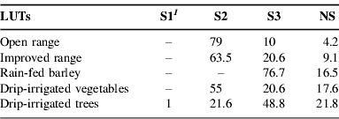
1 Suitability classes: S1, highly suitable; S2, moderately suitable; S3, marginally suitable; NS, not suitable.
Summary statistics of relevant land characteristics over the study area.

Comparing land suitability maps with the current land-use map
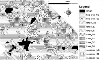
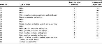
The highest agreement between suitability maps and the current land-use map was recorded for open-range (82%), followed by drip-irrigated vegetables (71%), while the agreement was very low in the case of trees (22%) and no agreement was found for field crops (Fig. 3). Variable agreement figures among different land utilizations are due to two factors. The first is the rating of different criteria for each land use and how close this rating is to the actual land-use requirements, and the second is that the farmer's decisions in selecting particular land-use type is not only governed by biophysical factors but incorporate socio-economic dimensions such as marketing, prices, input costs, availability of capital, technical know-how and farming traditions. The information gathered during the field visits were used to identify the farmers’ adopted practices for drip irrigation vegetables and drip irrigation trees (Table 5). Regarding the other LUTs, no specific management practices were identified by farmers and therefore their requirements were not modified.
Comparison between current land use and potential land suitability.

Management practices for drip-irrigated vegetables and drip-irrigated trees defined through farmers' interviews and average soil depth for each farm.

Revising land suitability evaluation
Based on field visits and farmers' interviews, successful cultivations of vegetables and trees under drip irrigation were recorded in the study area. Current land use and farmers’ improved managements that were explored formed a starting point to modify the level of limitation for drip-irrigated vegetables and drip-irrigated trees. Usually, researchers and land-use practitioners will assume the criteria that were suggested in Table 2. This highlights the important role of farmers' knowledge and current land-use data to suggest criteria and land-use types that are more relevant to the target area. These are usually overlooked in conventional land suitability analyses.
Regarding the limitation imposed by the WGPT, drip-irrigated vegetables are cultivated during summer or under plastic tunnels during the winter. Therefore, the WGPT was not considered as a limiting factor according to this assumption. The area of the modified suitability classes was compared with those of the original classification through area cross-tabulation. After the modification of the WGPT criterion, 18% of the area becomes highly suitable and 37% is moderately suitable for vegetables, while before modifying this criterion, the whole 55% of the area was moderately suitable. Based on this modification, more area could be recommended for vegetables, which is in more agreement with the current land use.
Land that was farmed with trees was classified as marginally suitable, mainly due to shallow soil depth and high stone content at the soil surface. However, farmers implement improved management practices to overcome these limiting factors. These include: the use of varieties that have a smaller root system (dwarf species), the implementation of a new tree-training technique (V system), the addition of a high amount of organic matter each year, irrigating the trees three times each week during summer and twice during winter, and the cleaning of rocks and stones from the soil surface. The new technique for the training of trees (V-shape system) was noticed in some farms, where the space between the trees within a row is 2 m only. V-shaped systems often provide higher yield but also need more water than other systems because trees are planted at closer spacing (more intensive farming practice).
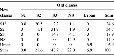
According to these assumptions the soil-depth criterion and rock outcrop/stones criterion were modified. Soil depth was modified according to the weighted average of soil depth, which was calculated for all farms that were visited. The average of soil depth for each farm was calculated using the observation points that exist in that farm. The weighted average for soil depth in these farms ranges from 55 to 103 cm (Table 5). The higher value of weighted average (103 cm) indicates the criteria ranking for highly suitable class (instead of 150 cm before modification), and lower value of weighted average (55 cm) indicates criteria ranking for moderately suitable class. The stones were not considered a limiting factor because farmers remove stones from their farms if necessary. Table 6 shows the criteria before and after modification, whereas Table 7 shows area cross-tabulation between original suitability classes and suitability classes after modifying the soil depth and rock outcrop/stones factors. In this table, the rows represent suitability classes after modifying the soil depth and rock outcrop/stones factors and the columns represent original suitability classes (without modifications).
Land-use requirements for irrigated vegetables and irrigated trees before and after modification based on farmers’ adopted practices.

1 Suitability classes: S1, highly suitable; S2, moderately suitable.
2 NL, not limiting.
3 WGPT, winter growth potential (summation of degrees >8°C during the coldest months).
4 AWHC, available water-holding capacity.
5 Erosion class: 1=nil, 2=slight, 3=moderate, 4=severe.
6 Stone content in the surface horizon.
Area cross tabulation between suitability classes before and after modifying soil depth and rock outcrop/stones factors for drip-irrigated trees.
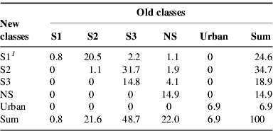
1 Suitability classes: S1, highly suitable; S2, moderately suitable; S3, marginally suitable; NS, not suitable.
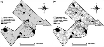
The results indicated that 25, 35, 19 and 15% of the total study area becomes highly, moderately, marginally and not suitable, respectively, for irrigated trees as a result of modifying the soil-depth and rock outcrop/stones criteria (Table 7), compared to 1, 22, 49, and 22%, respectively, before modifying these criteria. Generally, there is a shift toward better suitability classes as a result of this modification (Fig. 4). This is logical since the modification follows the farmer's management practices to overcome land-use limitations, which convert more land for better utilization. Based on this modification, more area could be recommended for trees, which is in more agreement with current land use.
Comparison of land suitability maps for irrigated trees for (a) original criteria and (b) modified criteria.

The results indicated that based on the modified criteria, which consider the farmers' adopted land-use practices specific to this area, a larger percentage (59%) of the study area is proposed for drip-irrigated trees compared to the area proposed for this utilization using the original criteria suggested by researchers (22%). Furthermore, 18% of the area is considered highly suitable for drip-irrigated vegetables using the modified criteria, while no land was considered highly suitable using the original criteria. Therefore, using the modified criteria, more land could be proposed for drip-irrigated trees and vegetables. This provides a good basis for the decision-making process that takes into consideration the available land resources and their sustainable use and management.
Conclusions
The agreement between current land use and potential land suitability depends on the type of land use under consideration, and in this study it ranged between 82% agreement for open range and no agreement for field crops. This is partially due to the method of suitability calculation and partially due to farmers’ adopted technologies to overcome land-use limitations. Potential suitability of land indicated a limited chance for cultivating trees and vegetables under irrigation. However, the current land-use pattern showed that large areas are utilized in this way. Field visits and farmers’ interviews indicated some management practices that are adopted by farmers, such as the cultivation of vegetables in summer or in winter under plastic tunnels to overcome the limitation imposed by low winter temperature. Other practices were implemented to overcome limitations imposed by soil and stone content to improve land suitability for irrigated trees. These include the use of dwarf varieties, a special training technique for trees, the addition of organic matter, a more frequent irrigation schedule and the removal of stones from the land surface. These farmers’ adopted techniques were used as a starting point to change the suitability criteria for the two utilization types. As a result of modifying these criteria, 18% and 24% of the area was re-classified as highly suitable for vegetables and trees, respectively. The revised land suitability results indicated that more land could be allocated for irrigated trees and vegetables, which is in agreement with the current land-use pattern in the study area. The approach followed in this study incorporates farmers' knowledge and provides the basis for undertaking wise decisions about the integrated use and management of land resources.