INTRODUCTION
All over the world marine waters are under increasing pressure from human activities affecting marine ecosystems. A wide range of human activities may operate at different and patchy spatial scales, both in coastal and in marine areas. In this context the quantification and the mapping of pressures in a standardized and comparable way represents a powerful tool for assessing the spatial pattern, the temporal change and the total impact of human pressures on natural systems (Halpern et al., Reference Halpern, Walbridge, Selkoe, Kappel, Micheli, D'Agrosa, Bruno, Casey, Ebert, Fox, Fujita, Heinemann, Lenihan, Madin, Perry, Selig, Spalding, Steneck and Watson2008, Reference Halpern, Frazier, Potapenko, Casey, Koenig, Longo, Lowndes, Rockwood, Elizabeth, Selig, Selkoe and Walbridge2015; Korpinen et al., Reference Korpinen, Meski, Andersen and Laamanen2012, Reference Korpinen, Meidinger and Laamanen2013). The need for sustainable management of human activities affecting marine environments and a prediction of the environmental outcomes has recently increased with environmental legislation such as the Marine Strategy Framework Directive – MSFD (2008/56/EC) and the emerging Maritime Spatial Planning – MSP (2014/89/EC) (Halpern et al., Reference Halpern, Diamond, Gaines, Gelcich, Gleason, Jennings, Lester, Macei, McCook, McLeod, Napoli, Rawson, Rice, Rosenberg, Ruckelshaus, Saier, Sandifer, Scholz and Ziviant2012; Korpinen et al., Reference Korpinen, Meski, Andersen and Laamanen2012; Halpern & Fujita, Reference Halpern and Fujita2013; Crise et al., Reference Crise, Kaberi, Ruiz, Zatsepin, Arashkevich, Giani, Karageorgis, Prieto, Pantazi, Gonzalez-Fernandez, Ribera d’Alcalà, Tornero, Vassilopoulou, Durrieu de Madron, Guieu, Puig, Zenetos, Andral, Angel, Altukhov, Ayata, Aktan, Balcioglu, Benedetti, Bouchoucha, Buia, Cadiou, Canals, Chakroun, Christou, Christidis, Civitarese, Coatu, Corsini-Foka, Cozzi, Deidun, Dell’Aquila, Dogrammatzi, Dumitrache, Edelist, Ettahiri, Fonda-Umani, Gana, Galgani, Gasparini, Giannakourou, Gomoiu, Gubanova, Gücü, Gürses, Hanke, Hatzianestis, Herut, Hone, Huertas, Irisson, Isinibilir, Jimenez, Kalogirou, Kapiris, Karamfilov, Kavadas, Keskin, Kideys, Kocak, Kondylatos, Kontogiannis, Kosyan, Koubbi, Kušpilic, La Ferla, Langone, Laroche, Lazar, Lefkaditou, Lemeshko, Machias, Malej, Mazzocchi, Medinets, Mihalopoulos, Miserocchi, Moncheva, Mukhanov, Oaie, Oros, Öztürk, Öztürk, Panayotova, Prospathopoulos, Radu, Raykov, Reglero, Reygondeau, Rougeron, Salihoglu, Sanchez-Vidal, Sannino, Santinelli, Secrieru, Shapiro, Simboura, Shiganova, Sprovieri, Stefanova, Streftaris, Tirelli, Tom, Topaloglu, Topçu, Tsagarakis, Tsangaris, Tserpes, Tugrul, Uysal, Vasile, Violaki, Xu, Yüksek and Papathanassiou2015). In particular, pressure and impact assessment is one of the key features of the EU MSFD (Anon., 2008) which applies the ecosystem-based approach to the management of human activities, ensuring that the collective pressure of such activities is kept within levels compatible with the achievement of a Good Environmental Status (GES) and that the capacity of marine ecosystems to respond to human-induced changes is not compromised, while enabling the sustainable use of marine goods and services by present and future generations (Art. 3 MSFD). According to the MSFD (Art. 8), each member state was required to carry out an initial assessment of its marine waters by 2012, taking into account existing data when available and comprising, among other aspects, an analysis of the predominant pressures and impacts, including human activity. In addition, because the Directive follows an adaptive management approach, the MSFD must be kept up-to-date and reviewed every 6 years (reporting cycles).
Within the MSFD one of the stressors directly affecting the Seafloor Integrity (Descriptor 6) is the Physical Loss pressure (PL) which represents the permanent or long-term alteration of the marine habitat (e.g. a change from a natural substrate to a man-made substrate, the loss of biogenic substrate etc.) and includes smothering and sealing (European Commission, 2012). Some authors (e.g. Eastwood et al., Reference Eastwood, Mills, Aldridge, Houghton and Rogers2007; Foden et al., Reference Foden, Rogers and Jones2011) attribute to smothering dredge material disposal, cuttings from well-heads and platforms, and to sealing the realization of oil and gas platforms and pipelines, well-heads, submarine cables, wind turbines, wrecks etc. The aim of this study was to propose a method to estimate the spatial extent of PL pressure and to determine the baseline condition in the Italian seafloor in the framework of the Initial Assessment phase of the MSFD. Furthermore, considering that human activities inducing PL pressure cause the loss of benthic habitats, and that the Mediterranean sea is characterized by sensitive and protected habitat types such as the biogenic substrates sensu MSFD, the distribution of PL pressure was overlaid with the distribution of the seabed habitats to estimate the loss of biogenic substrates.
MATERIALS AND METHODS
Study area
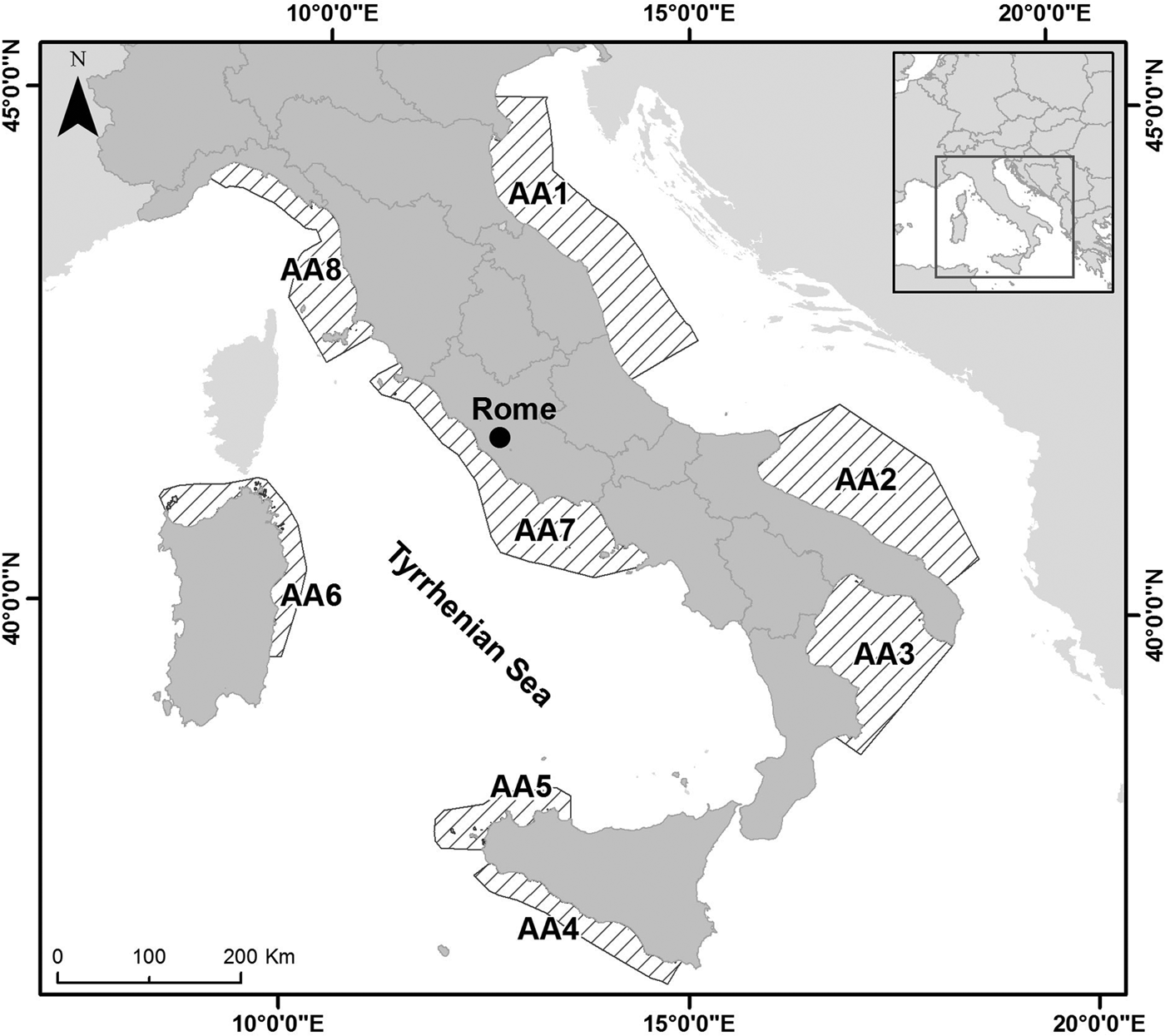
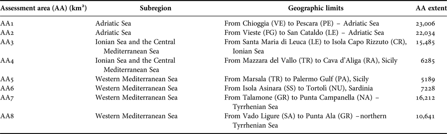
The study area, including all the Italian marine waters, is represented by the eight specific Assessment Areas (AAs) identified for the PL pressure in the framework of the Initial Assessment phase of the MSFD (Art. 8, Directive 2008/56/EC). According to the MSFD criteria, Assessment Areas were selected taking into account the spatial distribution of the pressure (pressure gradient), the different types of human activities, the presence of protected/sensitive habitat types and the physical, chemical and hydrological characteristics. The Assessment Areas were named moving anticlockwise from AA1 to AA8; they generally extend offshore up to the limit of territorial waters or up to the middle line (Figure 1). In Table 1 for each AA subregion, the geographic extension and the total AA extension (km2) were reported.
Study area: Assessment Areas (AAs) identified in the Italian seas.

Description of the Assessment Areas (AAs): subregion, geographic limits and extent.

Data source and processing method
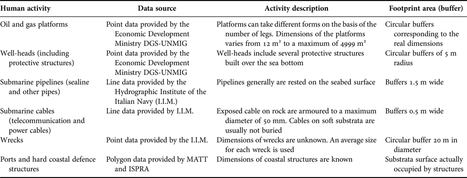
The first step in achieving the objectives of this study was to determine which human activities taking place in coastal and offshore waters could induce PL pressure. Considering that historical data on PL-related human activities (such as ports, coastal defence works etc.) are often not available, it was decided to establish a baseline condition, gathering all available information, although referring to structures dating back to the period before the first reporting cycle of the MSFD (2006–2012). Spatial data on the distribution of human activities in Italian marine waters were obtained by consulting different official sources: the Economic Development Ministry DGS-UNMIG (Directorate-General for Safety of Mining and Energy Activities – National Mining Office for Hydrocarbons and Georesources), the Hydrographic Institute of the Italian Navy (I.I.M.) and the Italian Ministry for the Environment, Land and Sea (M.A.T.T.M.) (Table 2). The identified human-activities inducing PL pressure include: oil and gas platforms, well-head protective structures, submarine pipelines and cables, wrecks, coastal defence structures and ports, disposal of military obsolete ordnance. Each activity was generally represented using points, lines or polygons. When available, real dimensions were used to produce representative footprint areas; otherwise when activities were depicted by lines or points it was necessary to establish specific and standard buffers. To compute standard buffers (footprint areas), information was obtained from literature (Eastwood et al., Reference Eastwood, Mills, Aldridge, Houghton and Rogers2007; Foden et al., Reference Foden, Rogers and Jones2008, Reference Foden, Rogers and Jones2009, Reference Foden, Rogers and Jones2011) and through the use of expert judgement by applying the precautionary principle. In particular the following section describes the processing methods used to transform data into a standardized estimation of the spatial extent for PL related human activities (Table 2).
Human activities inducing Physical Loss (PL) pressure in the Italian sea bottoms.

OIL AND GAS PLATFORMS
Geospatial data were obtained from the Economic Development Ministry DGS-UNMIG as punctual data. Considering that on the basis of the number of legs, platforms can take different forms, we used the real dimensions when available. Dimensions, varying from 12 m2 to a maximum of 4990 m2, were represented in GIS as a circular buffer of an equivalent area.
WELL-HEADS (INCLUDING PROTECTIVE STRUCTURES)
Spatial data were provided by the Ministry of Economic Development DGS-UNMIG as punctual data. Considering that the real dimensions of a single well-head including protective structures, were not always available, the spatial extent of the area affected by the structures was calculated as 70 m2 by using accessible information. Each well-head was represented using a circular buffer of 5 m radius.
SUBMARINE CABLES
Geospatial data related to cable layouts, such as one dimensional-line vectors, were provided by the I.I.M. Considering the great variability of the methods used to install submarine cables on the Italian sea bottoms which depend not only on the morphological characteristics of substrata (presence of sensitive or protected habitats, rocks, etc.) but also on the methods used to armour and fully or partially cover them with concrete or other mechanical protection, we decided to use a precautionary principle by applying a standard buffer 0.5 m wide.
SUBMARINE PIPELINES (SEALINE AND OTHER PIPES)
Geospatial data for all pipelines were provided by the I.I.M. Submarine pipelines (sealines, pipes and sewage pipes) were represented as one dimensional-line vectors using a standard buffer 1.5 m wide.
WRECKS
Spatial data for all wrecks were obtained from the I.I.M. Wrecks are represented as point locations. Considering that wrecks vary in size and shape, as specific information was not always available, we used standard dimensions to generate representative footprints (spatial extent estimates) for these activities. Therefore, on the basis of all available length and width measurements we attributed to each wreck an average size represented by a circular buffer 20 m in diameter.
PORTS AND HARD COASTAL DEFENCE STRUCTURES
Geospatial data such as polygon vectors were provided by the Italian Ministry for the Environment and Land Protection (http://www.pcn.minambiente.it/mattm/en/view-service-wms/) and by ISPRA (Barbano et al., Reference Barbano, Corsini, Mandrone, Paone and Rotunno2006). To estimate their spatial extent, we represented the substrata surface actually occupied by structures which was obtained by photo interpretation.
DISPOSAL OF MILITARY OBSOLETE ORDNANCE
Spatial data related to the disposal of military obsolete ordnance were obtained from I.I.M. In order to assess the surface affected by these materials, we multiplied the military permitted areas by a percentage of 0.000015. This percentage was calculated by using available information on recovered unexploded military materials in the southern Adriatic sea, and by assuming that the physical loss caused by fire for shooting activities (military areas) was not greater than the loss resulting from the sinking of ordnance (draft from European Project REDCOD – Research on Environmental Damage caused by Chemical Ordnance Dumped at Sea).
Method to estimate PL pressure
Spatial extent of human activities PL-related were mapped and estimated in each Assessment Area (AA) and in two sub-areas extending up to 500 m and up to 3 nm from the coastline, as they represented, respectively, a significant area for the presence of sensitive and protected coastal habitats and a protected zone from trawling (sensu EC Regulation 1967/2006). Moreover, in accordance with the MSFD requirements to compare the different pressures affecting the seafloor integrity (such as sealing, abrasion, extraction etc.) and to spatialize data, a gridding process was realized taking into consideration the above mentioned subdivision: the whole AA (cell%_AA) and the subareas extending respectively up to 3 nm (cell%_3 nm) and up to 500 m (cell%_500 m) from the coast. In particular a regular grid of 250 m × 250 m cells was used.
Considering that PL pressure is defined as a permanent change in the seafloor and can produce significant impacts in relation to the different habitat types potentially involved, it was decided to estimate PL pressure affecting the predominant habitat types sensu MSFD. In order to identify these predominant habitat types, the grid related to the average % of the cell affected by pressure was overlaid with the distribution habitat type grid derived from the European Project EUSeaMap (https://www.emodnet-seabedhabitats.eu.). Both grids have the same origin, extent and spatial resolution (250 m × 250 m).
Moreover, it was decided to focus attention on the biogenic substrates sensu MSFD, since they include very sensitive and/or protected habitat types: Posidonia oceanica meadows, cold water corals, reefs, coralligenous biocoenosis and maërl beds (Rice et al., Reference Rice, Arvanitidis, Borja, Frid, Hiddink, Krause, Lorance, Ragnarsson, Sköld, Trabucco, Enserink and Norkko2010). Pressure spatial data (such as polygonal feature-class) were overlaid with the distribution of biogenic substrates derived from the following web portals: GIS Natura (www.pcn.minambiente.it/GN/), Atlante degli Habitat Marini della Regione Liguria (http://www.regione.liguria.it/sep-servizi-online/catalogo-servizi-online/opendata/item/7070-atlante-degli-habitat-marini-sc-1-10000-2009.html).
Although data on coastal biogenic substrates are generally updated and detailed, it is likely that PL pressure may have been underestimated because of the lack of information on coastal habitats present before the construction of structures (e.g. defence structures, ports etc.). The estimation of the PL pressure on biogenic substrates in offshore waters (such as coral reefs, coralligenous biocoenosis, tegnùe etc.) has been probably underestimated as their mappings were scarce and their scale of investigation not adequate.
All data manipulation and analysis were estimated and mapped using GIS tools (ArcGIS 10.3).
RESULTS AND DISCUSSION
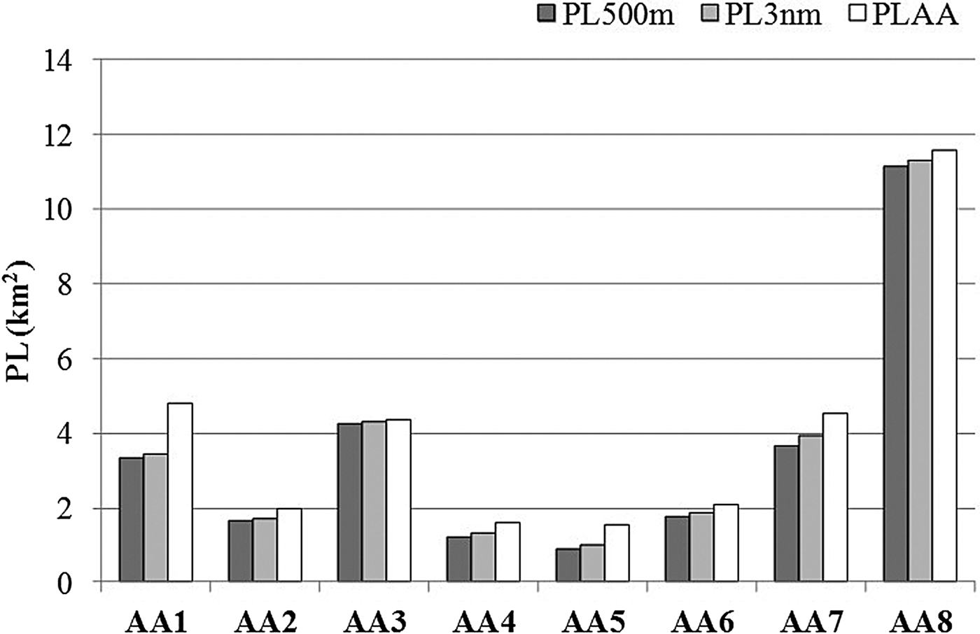
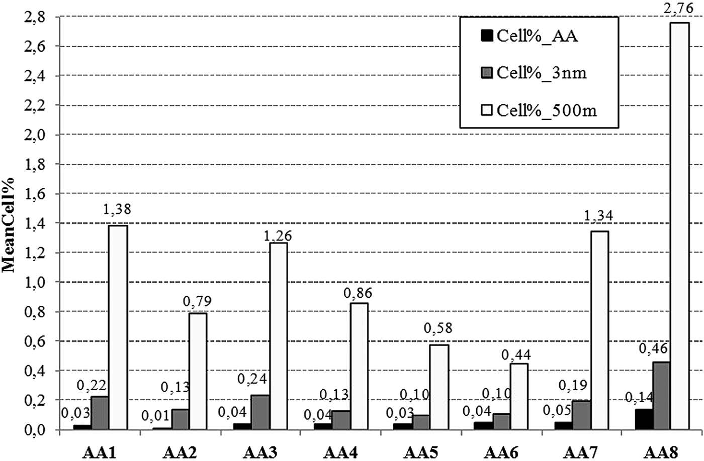
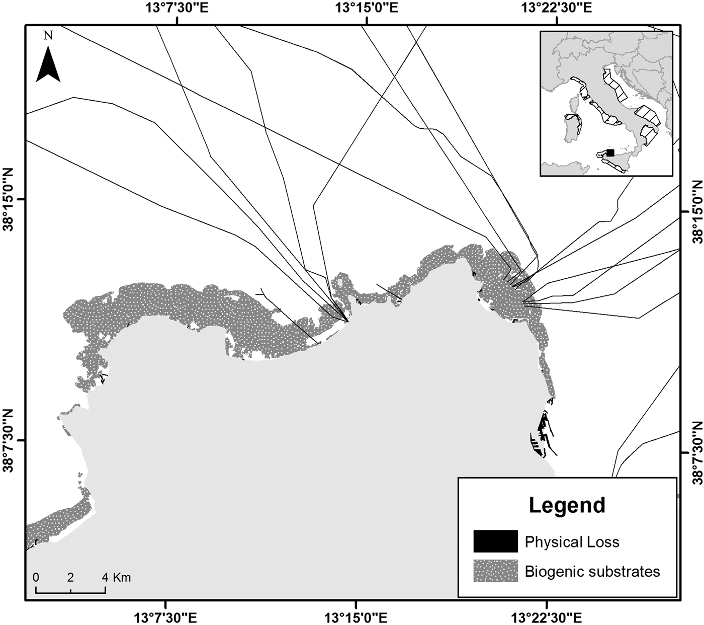
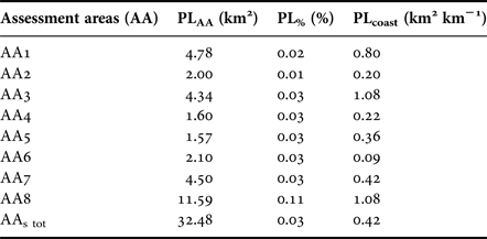
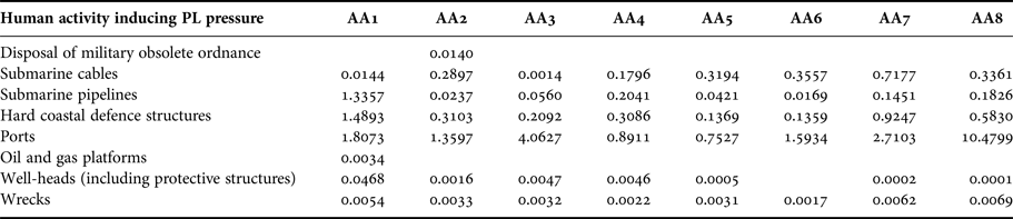
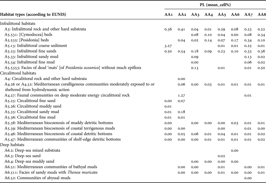
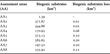
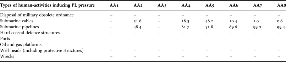
The results showed that the PL pressure in Italian waters, including both the smothering and the sealing components as per MSFD, was exclusively represented by sealing. Smothering, which is generally associated with the disposal of dredged materials and the drill cuttings from oil and gas exploration (Foden et al., Reference Foden, Rogers and Jones2011), was shown to be absent. Regarding the disposal of port materials, smothering was not expected because the Italian legislation permits this activity only in marine areas with grain size characteristics similar to those of dumped sediments (D.M.173 15/07/2016). Moreover, in the study period no authorization for the dumping of drilling mud was granted and therefore smothering was not present. PL pressure in the Italian seas showed low values, corresponding to about 32 km2, which represents 0.03% of the total AAs (Table 3). The highest values were observed in AA8 (from Vado Ligure to Punta Ala in the Tyrrhenian Sea) corresponding to about 11.59 km2; in the other AAs values are lower and comprised between 1.57 km2 (AA5, from Marsala to Palermo Gulf, Sicily) and 4.78 km2 (AA1, from Chioggia to Pescara in the northern Adriatic Sea). PL pressure was analysed taking into consideration two stretches of AA extending up to 500 m and up to 3 nm from the coastline, as they represent, respectively, a significant area for the presence of sensitive and protected coastal habitats and a protected zone from trawling (sensu EC Regulation 1967/2006). Figure 2 reported the estimation of PL (in km2) in the whole AA (PLAA) and in the two stretches of AA extending respectively up to 500 m (PL500 m) and up to 3 nm (PL3nm) from the coastline. Most of PL pressure was concentrated in the sub-area extending up to 500 m from the coastline (PL500 m), a significant permanent seafloor degradation was not observed between PL500 m and PL3 nm. The remaining low contribution to the pressure was found in the waters beyond 3 nm. In the three different areas considered (PLAA, PL3nm and PL500 m) in AA3 (Gulf of Taranto, Ionian Sea) a substantial stability of values was observed (Figure 2). This result was probably due to the greater extension of the evaluated coastline in relation to the total area of the AA itself. According to what has already been detected in extra-Mediterranean contexts, the results obtained confirmed the irregular distribution of the PL pressure which tended to concentrate in the inner continental shelf (Foden et al., Reference Foden, Rogers and Jones2011; Moreno et al., Reference Moreno, del Barrio, Lloret and Perez-Puyol2012). In order to compare data related to areas with different size and shape, PL pressure values were correlated to the coastal extension of each AA (PLcoast) (Table 3). The AAs more exposed to the pressure were AA3 (Gulf of Taranto, Ionian Sea) and AA8 (from Vado Ligure to Punta Ala in the Tyrrhenian Sea) with a loss of about 1 km2 km−1. The minimum loss value per linear km of 0.2 km2 km−1 was detected in AA2 (southern Adriatic sea), meaning that this was less exposed to PL pressure. PL pressure was primarily generated by ports and hard defence structures, secondly by submarine cables and pipelines (Table 4). In particular, all the AAs ports always provided the highest values, ranging from 10.48 km in AA8 (from Vado Ligure to Punta Ala in the Tyrrhenian Sea) to 0.76 km in AA5 (from Marsala to Palermo Gulf, Sicily), followed by coastal defences in almost all the AAs (Table 4) with the exception of AA5 and AA7 (from Talamone to Punta Campanella in the Tyrrhenian Sea). In these areas the second contribution was provided by cables; this was probably due to the geographic characteristics (greater presence of rocky coasts) and the socioeconomic characteristics of the two AAs (the different degree of urbanization caused a different incidence of coastal defence works). The different types of human activities were present in all the AAs, even if with different degree of coverage. Hydrocarbon extraction platforms and disposal of military obsolete ordnance were observed only in specific geographic areas, respectively in AA1 and AA2 (both assessment areas are in the Adriatic sea). In compliance with the requirements of the MSFD to assess the different pressures affecting the seafloor integrity (such as sealing, abrasion, extraction, etc.) and to spatialize data, a gridding process was realized. With regard to PL pressure we took into consideration the whole AA (cell%_AA) and the sub-areas extending respectively up to 500 m (cell%_500 m) and up to 3 nm (cell%_3 mn) from the coast. The average percentage of the cell occupied by PL pressure in all the AAs varied between 0.01 and 0.14% in AA8 (from Vado Ligure to Punta Ala in the Tyrrhenian Sea) and in AA2 (southern Adriatic Sea). With regard to the 3 nm sub-area (cell%_3 nm) the average values ranged from 0.10% (in AA5 and AA6) to 0.46% (AA8); finally in the 500 m sub-area (cell%_500 m) values increased significantly, ranging between 0.44 and 2.76% respectively in AA6 and in AA8 (both in the Tyrrhenian sea) (Figure 3). The increase of the average percentage of the cell occupied by PL pressure in all the AAs moving toward the coast (the stretch of AA extending up to 500 m), confirmed what has been previously observed, that is, the peculiar distribution of the PL tending to concentrate in the inner continental shelf, and more precisely, in coastal waters. As already mentioned, considering that Physical Loss causes a permanent change of the seafloor and that it can produce significant impacts in relation to the habitats potentially involved, it was decided to estimate PL pressure affecting the predominant habitat types sensu MSFD (Rice et al., Reference Rice, Arvanitidis, Borja, Frid, Hiddink, Krause, Lorance, Ragnarsson, Sköld, Trabucco, Enserink and Norkko2010). In order to identify these predominant habitat types, the grid related to the average percentage of the cell affected by pressure was overlaid with the distribution habitat type grid derived by the Project EUSeaMap (Eunis habitat map). Table 5 shows, for each AA, the average percentage of grid cell interested by PL pressure for each habitat type classified according to EUNIS. PL pressure showed the highest average percentage of occupancy with regard to infralittoral habitats (characterized by Posidonia oceanica meadows and Cymodocea nodosa beds) and with regard to other habitats typical of the infralittoral sand, gravel and mud; these habitat are generally localized up to 40 m of water depth (Pérès & Picard, Reference Pérès and Picard1964). In particular, Posidonia oceanica meadows (Eunis Habitat Code: A5.535) which represents a priority habitat under the EU Habitats Directive, and which is also considered a biogenic substrate sensu MSFD, in some AAs (AA4, AA6, AA7) it reached the highest values of average percentage of occupancy. The average percentage of the cell occupied by PL pressure for each habitat type tended to decrease moving offshore. The relatively high value registered for the habitat ‘A5.13 – Infralittoral coarse sediment’ in AA1 (in the northern Adriatic sea) was presumably due to its limited extension, of a few km2. Moreover, it was decided to focus the attention on biogenic substrates sensu MSFD, since they include sensitive and/or protected habitat types (Rice et al., Reference Rice, Arvanitidis, Borja, Frid, Hiddink, Krause, Lorance, Ragnarsson, Sköld, Trabucco, Enserink and Norkko2010). Table 6 shows, for each AA, the estimation of the area (km2) characterized by the presence of biogenic substrates and of the area (km2) affected by PL pressure. In all the AAs data on biogenic substrates affected by PL pressure generally showed low values, ranging from 0.2 km2 in AA6 and AA7 to 0.01 km2 in AA2. These values could have been underestimated because data on biogenic substrate distribution in offshore waters are rather scarce and/or not adequate. A map overlaying the Physical Loss pressure on the biogenic substrate distribution in AA5 (in the Tyrrhenian Sea) is shown in Figure 4. Table 7 shows, for each AA, the estimation (per cent) of biogenic substrates affected by each type of human activity PL-related. The loss of biogenic substrates was exclusively due to the presence of cables and pipelines. Particularly in AA2 and AA5 this loss was equally divided, while in the other AAs the loss of biogenic substrates was attributable almost entirely to pipelines; this result was closely related to the distribution of coastal biogenic substrates. Finally, we must consider that PL pressure affecting biogenic coastal substrates could have been underestimated. In fact, as data on the distribution of coastal habitats present before the construction of ports and defence works were not available, it was not possible to quantify such loss in relation to each habitat.
Distribution of Physical Loss (PL) pressure, expressed in km2, in the whole AA (PLAA), and in the two sub-areas extending up to 500 m (PL500 m) and up to 3 mn (PL3nm) from the coastline.

Average percentage of the cell occupied by Physical Loss (PL) pressure in all the AAs (cell%_AA), in the 3 nm sub-area (cell%_3 nm) and in the 500 m sub-area (cell%_500 m) from the coastline.

Map overlaying the Physical Loss (PL) pressure on the biogenic substrate distribution in AA5 (Tyrrhenian Sea).

Estimation of Physical Loss (PL) pressure in each AA expressed in km2 (PLAA) and in per cent (PL%), and PL correlated to the coastal extension (PLcoast), expressed in km2 km−1.

Contribution for each AA, in km2, of different types of human-activities inducing Physical Loss (PL) pressure.

Average percentage of the cell occupied by Physical Loss (PL) pressure for each habitat type according to EUNIS.

Estimation (km2) of biogenic substrates sensu MSFD and their loss because of Physical Loss (PL) pressure in each AA.

Estimation (%) of biogenic substrates affected by each type of human activity inducing Physical Loss (PL) pressure.

CONCLUSIONS
The results of this study represent the first attempt to estimate the spatial extent of Physical Loss pressure in the Italian seas in the framework of the Initial Assessment Phase of the MSFD. In the reference period (2006–2012) Physical Loss was exclusively represented by sealing; smothering was absent. Physical Loss pressure showed low values of coverage, about 32 km2, corresponding to 0.03% of the study area (including all the AAs); its distribution was quite regular in the coastal zone tending to become irregular and sporadic moving offshore, as observed in extra-Mediterranean countries (Foden et al., Reference Foden, Rogers and Jones2011; Moreno et al., Reference Moreno, del Barrio, Lloret and Perez-Puyol2012). Generally human activities which mainly contributed to this pressure were represented by coastal defences and ports, cables and pipelines (Moreno et al., Reference Moreno, del Barrio, Lloret and Perez-Puyol2012; Andersen et al., Reference Andersen, Stock, Mannerla, Heinänen and Vinther2013). Furthermore, the results registered low values of biogenic substrate loss in all the AAs, ranging from 0.2 to 0.01 km2. Even if the biogenic substrate loss resulted to be spatially very limited in each AA, the Physical Loss pressure affected particular habitats such as Cymodocea nodosa beds and Posidonia oceanica meadows. This study has allowed the detection of some critical issues; first, the choice of the buffers to map human activities inducing PL pressure, mainly based on the expert judgement by applying the precautionary principle. Sometimes the lack of specific information related to each structure/activity could have influenced the accuracy of the footprint area. Another critical issue was the lack of suitable data and knowledge regarding the nature and distribution of biogenic substrates in the Italian sea bottoms, which could have led to an underestimation of their loss because of PL pressure. It follows that an accurate and high resolution habitat mapping is necessary for a more precise pressure and impact assessment with the aim of an effective and sustainable management and monitoring of human activities impacting marine environments (Crise et al., Reference Crise, Kaberi, Ruiz, Zatsepin, Arashkevich, Giani, Karageorgis, Prieto, Pantazi, Gonzalez-Fernandez, Ribera d’Alcalà, Tornero, Vassilopoulou, Durrieu de Madron, Guieu, Puig, Zenetos, Andral, Angel, Altukhov, Ayata, Aktan, Balcioglu, Benedetti, Bouchoucha, Buia, Cadiou, Canals, Chakroun, Christou, Christidis, Civitarese, Coatu, Corsini-Foka, Cozzi, Deidun, Dell’Aquila, Dogrammatzi, Dumitrache, Edelist, Ettahiri, Fonda-Umani, Gana, Galgani, Gasparini, Giannakourou, Gomoiu, Gubanova, Gücü, Gürses, Hanke, Hatzianestis, Herut, Hone, Huertas, Irisson, Isinibilir, Jimenez, Kalogirou, Kapiris, Karamfilov, Kavadas, Keskin, Kideys, Kocak, Kondylatos, Kontogiannis, Kosyan, Koubbi, Kušpilic, La Ferla, Langone, Laroche, Lazar, Lefkaditou, Lemeshko, Machias, Malej, Mazzocchi, Medinets, Mihalopoulos, Miserocchi, Moncheva, Mukhanov, Oaie, Oros, Öztürk, Öztürk, Panayotova, Prospathopoulos, Radu, Raykov, Reglero, Reygondeau, Rougeron, Salihoglu, Sanchez-Vidal, Sannino, Santinelli, Secrieru, Shapiro, Simboura, Shiganova, Sprovieri, Stefanova, Streftaris, Tirelli, Tom, Topaloglu, Topçu, Tsagarakis, Tsangaris, Tserpes, Tugrul, Uysal, Vasile, Violaki, Xu, Yüksek and Papathanassiou2015). Despite the critical issues that have emerged, this method represents a useful tool for establishing the baseline condition for Physical Loss pressure, to compare future conditions and to evaluate different management scenarios. Furthermore it allows the identification of the areas where pressure tends to accumulate as ‘hot spots’ on which future impact analyses could focus, and the areas where few stressors are present. We emphasize that this study has exclusively evaluated Physical Loss pressure, whereas in order to assess the Seafloor Integrity under the MSFD, pressures and impacts associated with Physical Damage (i.e. change in siltation, abrasion and selective extraction) must also be analysed. For this reason, future developments could be the application of the proposed method to the other pressures acting on the seafloor with the aim of assessing the real extension of these human pressures as well as the consequent combined or cumulative impacts (Stelzenmüller et al., Reference Stelzenmüller, Lee, South and Rogers2010).