

During the long nineteenth century, emerging bureaucratic states sought to align boundaries of space, political authority, and social identity. According to the normative ideal, ramified systems of delegated control should be consolidated into a single government, state power evenly applied throughout the entire area, and patchworks of local identities replaced with uniform citizenship. However, as Bayly has observed, states remained composite, negotiating with subordinates who retained their own spheres of influence.Footnote 1 Integration was contested, uneven, and by no means linear. These tensions were evident in cities, with their traditions of trade and migration, and in colonial societies, characterized by the symbiosis between communal leaders and imported officials. However, even here informal controls were supplemented by state-sponsored social discipline as military power, managerial capacity, and populations expanded. Social categorizations were more rigidly enforced. Settlements and regulations became more closely packed, shrinking unclaimed space, both physical and social.
The claiming of space, like processes of social identification, is highly political and deeply cultural. Raw power is most evident in the case of the former because space is a desirable resource, albeit one of variable value. Shifts in population, the means of production, and transport technology affect demand, as do changing habits and expectations. These combine to shape urban morphology, neighborhoods, and housing. The spatial market is not merely money-based; political ideology and ability, factional loyalties, and personal ties can be more relevant, particularly when land is government controlled. A strong legal framework may channel the allocation and use of land, but even entrenched laws are unevenly applied and accepted.Footnote 2 Diverging moral economies create differing ideas of entitlement, entangled with race, religion, class, and citizenship.
The suggestion that “pre-modern societies” possessed “a limited range of common rhetorics” that formed “all-encompassing identity schemes” such as religion and kinshipFootnote 3 may be valid for rural hinterlands, but not for trading states, empires, and emporia, including those of Europeans in Asia.Footnote 4 All had to manage the interplay among social variation, political process, and economic exploitation. Categories of practice used by both group members and observers typically emphasized apparently fixed social attributes: religion, ethnicity, kinship, and rank. However, judicious partnerships (including of marriage) and cultural adaptation permitted self-reinvention under shifting constraints and opportunities. Identification seemed both essential and contingent: labels were imposed, invented, and deployed, but also inherited and reinterpreted. In the course of time they accrued great emotional power, becoming forceful explanatory tools with their own capacity to shape events.
Pre-colonial Asian ports, like traditional Islamic urban centers, were once seen as mosaics of separate quarters, self-regulating corporate neighborhoods under leaders of their own, though subject to a paramount ruler. Current scholarship emphasizes citywide political practice. Though patrimonial elites may have mobilized cultural affiliations within their own districts, successful participation in the broader struggle for influence required trans-communal cooperation, which also provided access to community-specific forms of capital, economic, social, and political.Footnote 5 Nevertheless, the designation of communal wards did recognize each group's place in urban society, granting legitimacy and the right to representation. As was the case in other spaces elsewhere, such quarters were “escaped and transgressed,” but even so they were “both ‘real’ in some sense and creative of social reality that escaped spatial boundaries.”Footnote 6 Wealth-based class in such cities has received less attention than ethnicity,Footnote 7 when in fact the two hierarchies were mutually reinforcing.
Under high imperialism, Western ideas of modernity increasingly dominated nineteenth-century public institutions and private lives, strengthening similarities despite an intensifying discourse of division.Footnote 8 Two of the most influential pre-war theorists of colonial political economy, J. H. Boeke and J. S. Furnivall, attempted to clarify the complex interaction between capitalism, policy, development, culture, and ethnicity. Boeke's “dual economy”Footnote 9 and Furnivall's “plural society”Footnote 10 are still frequently cited, although they are tainted by fixed typologies and hints of essentialism. They were inspired by Dutch attempts to manage the East Indies, a sprawling archipelago of states and “tribes” where regional ethnicities (over 250 languages) and the suspect economic proclivities of the Chinese minority resisted integration. After 1945, similar recalcitrance challenged the Indonesian state.Footnote 11
In this article I take particular places as objective correlatives for largely hidden processes, and explore the ways in which political priorities and social segmentation shaped two sites in the East Indonesian port-town of Makassar over several centuries.Footnote 12 I hope to convey some sense of how the reach of the state, social categorization, and ideas of entitlement have changed. Like every place, Makassar is atypical, and the material presented here is of necessity anecdotal and usually state-centered. Most sources reflect bureaucratic priorities and assume that political elites had overriding rights to resources (including land), and that society was naturally divided into religious and ethnic communities. Neither assumption is so openly espoused today, but both remain stubbornly relevant.
The two sites I will discuss in detail are Karebosi square, or common, and Makassar's waterfront, particularly the stretch known as Losari. Like most of Makassar's land, both iconic spacesFootnote 13 were, and are, state-owned, but they have remained open to all. They are not merely public but are special and shared. Everyone in the city, regardless of class or ethnicity, seems to have memories of Karebosi and Losari. Children, families, friends, groups of adolescents, and romantic couples all gravitate to these ramai (bustling, lively) locations with their famous food stalls. Both are “structures of feeling,” “simultaneously practical, valued, and taken for granted,” “inherently fragile social achievement(s).”Footnote 14
Makassar may once have seemed an almost archipelagic mosaic of theoretically ethnic settlements, but as it grew, the “spaces in between” contracted. Karebosi and Losari survived for different reasons. The former, a central site of considerable value, has been protected by tradition, and its public status pre-dates the assertion of Dutch power (1669). Losari was initially an environmentally precarious kampung quarterFootnote 15 on the edge of town and it only came to attract Europeans in the 1930s. During the later nineteenth and twentieth centuries both spaces became smaller and their public identities more defined, as surrounding areas were absorbed into an ever-more regimented town, but they remained accessible, places where people could “construct their own worlds through various routines.”Footnote 16 Today they seem increasingly fragile, as property developers and the middle-class, buoyed by economic growth, set their stamp on the city.
In what follows, I will first introduce Makassar itself, and then present the two localities' histories from the early seventeenth century to about 1965. The next section traces later twentieth-century littoral development under, first, Indonesia's authoritarian New Order (1965–1998), and then the more democratic regimes of the subsequent Reformasi.Footnote 17 I complete the descriptive narrative with a discussion of controversial recent plans for Karebosi. My conclusion returns to broader questions of politics, space, race, and class.
Makassar
For most of its history, Makassar was a long, thin, polycentric town squeezed between the eponymous straits to the west and swampy terrain to the east. By the early seventeenth century, its strategic location between China, Java, Kalimantan (Borneo), and Maluku (the Moluccas) had enabled the Makassarese-speaking Gowa-Talloq kingdom to create a successful capital and entrepôt. Makassar became a conglomeration of courts, forts, villages, and island-sheltered anchorages, stretching from the Talloq River in the north down to the Jeneberang, where the fortified center of Somba Opu protected Indian, Chinese, Portuguese, English, and other foreign merchants.Footnote 18 Neighboring seashores and marshlands were inhospitable, the beaches lashed by storms during the west monsoon; inland villages huddled on relatively dry patches of elevated land. Political control, centered on kinship rather than notions of territorial integrity, was most densely concentrated in particular sites.Footnote 19
In 1669 the VOC (Dutch East India Company), in alliance with the Bugis kingdom of Bone, reduced Gowa-Talloq's attenuated capital to a proto-colonial enclave centered on the massive Fort Rotterdam. Immigration and trade were severely curtailed, old commercial networks dismantled, and many foreigners departed. Conquest conferred command over the land and its inhabitants. Like both Gowa-Talloq before it and the subsequent East Indies, the Company consigned authority and exploitation rights over people and resources to those who could deliver security, manpower, and indirect taxation, or, in the case of farmed monopolies, money and management. Most settlements were ruled by political proxies with control over territory, who could allocate fields to cultivate or places to live. Unused land outside such fiefdoms, while theoretically of the state, was regarded as public. Such spaces were largely unregulated, and they could become illicit neighborhoods, squatters' gardens, or centers of lawlessness. Typically, this occurred at the margins of settlement or on less attractive ground, but population pressure or a questioning of authority could encourage what were seen as legitimate expropriations, as happened with European- and Chinese-owned property beginning in the 1940s.
Makassar's post-conquest history was determined by three essentially external forces: the Java-based polities in which it was embedded, international trade, and relations with neighboring peninsular states. An outpost of the VOC (1669–1800), Makassar then became a regional center in the colonial Dutch East Indies (1800–1942), the headquarters of the Japanese Navy's Southwest District (1942–1945), the contested capital of Dutch East Indonesia (1945–1949) and finally an Indonesian provincial capital (from 1945, or 1949).Footnote 20 Makassar was also a trans-regional trading hub, so it was pulled towards both the political capital of Batavia/Jakarta and the burgeoning commerce of the South China Sea, and was torn between politically imposed centripetal and commerce-driven centrifugal forces. Ties with China escalated, following shifting trade patterns. After 1746, a direct junk link with Xiamen (Amoy) deepened Makassar's China-dependence,Footnote 21 which was, contrary to Dutch hopes, confirmed after 1847 when the port, freed of most taxes, became an important subsidiary in the South China Sea traffic. All governments distrusted external links that threatened their hegemony: the Dutch feared Buginese and Makassarese loyalties to nearby kingdoms, while after independence Chinese and Europeans were suspect.
Fort Rotterdam housed the Company's main officials and garrison. The neighboring small settlement of Vlaardingen was initially populated by Moors (Indian Muslims), Malays, indigenous Makassarese, and Buginese, as well as Christians and Chinese. But the VOC expelled distrusted Asians, imposed buffer zones, razed buildings to clear fields of fire, and rebuilt town walls to accommodate eastward expansion. Eighteenth-century Makassar typically included a free population of two thousand (later growing to three), consisting of about nine hundred Company employees (mostly military), some four hundred Europeans (predominantly mestizo), and roughly similar numbers of Sulawesians, Chinese, and Malays. Mestizos were creoles of mixed descent, but legally European. Like the peranakan (locally-born) Chinese, many of whom were Muslim, they were heavily acculturated, blending elements from various communities. This was encouraged by slavery, since households included more Asian slaves than free members. By the end of the eighteenth century, the kampung of the wider urban agglomeration were crammed with immigrants from the hinterland, their population probably exceeding six thousand.Footnote 22
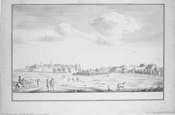
Makassar c. 1750. View from the landward side, looking west; the path on the left would be the Hogepad to Bontualaq. J. M. Aubert (Rijksmuseum Amsterdam Amsterdam, RP-T-00-3234).

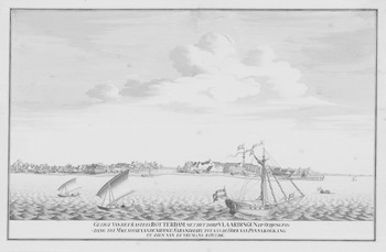
View from the Sea of Makassar, showing Ford Rotterdam and the Village of Vlaardingen c. 1750 (detail) (Rijksmuseum Amsterdam).

Politically, Makassar was a puzzle. Two competing states, the VOC and Bugis Bone, held territory there. Bone's kings ruled both their east-coast kingdom and, less than half an hour from the Company's fort, an enclave at Bontualaq. There they spent several months each year, nurturing their uneasy alliance with the Dutch and asserting their authority within the town's Bugis quarters.Footnote 23 The pre-colonial centers of Makassarese Gowa and Talloq were also nearby. Although these had no formal role whatsoever in the new settlement, they retained great prestige in the southern kampung, even though the hereditary chiefs there were theoretically VOC appointees. Sulawesian inhabitants of Makassar's “free villages” were Dutch subjects under a specialized European official, but many immigrants were still de facto followers of their original leaders. Such ties remained strong even after the kingdoms were incorporated into the colonial state in the early 1900s. The VOC umbrella sheltered Christians of all sorts, who were administered by church and state, as well as immigrant “nations” such as the Chinese and Malays governed through their own communal officers. Fringe areas under Dutch hegemony were embedded within local states. Consequently, authority within Makassar was divided among a European trading company, self-governing immigrant quarters, miscellaneous native kampung, a Buginese state, and a disenfranchised former kingdom.
In all of the communities, patronage shaped politics, which were personal and often arbitrary. Connections determined one's ability to appeal to urban institutions, which were hedged by procedures and guarded by gatekeepers. Without the protection that patronage could confer, commoners were relegated to social or geographical margins and interstices. However, the pattern of daily life was woven by close and often intimate social and economic interactions among people living under separate administrations. Cooperation between elites stabilized the system, which was predicated upon accepted hierarchy and communal division; the former was seldom challenged before the later twentieth century, but the latter was always problematic, and increasingly so from the mid-1800s onward.
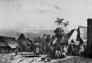
The Malay Kampung, Makassar, c. 1840, depicting Indonesians, Chinese, Europeans, and Arabs. From P. Van der Velde, Gezigte uit Neerlands Indie (Amsterdam: Buffa 1845).

The British interregnum (1812–1816) and the later nineteenth century were particularly transformative times for Makassar. Both conviction and necessity led the British to abandon VOC habits. They needed and favored mestizo officials, a trend the Dutch later reversed.Footnote 24 The British also curtailed Bugis influence—they expelled the Bone ruler from Bontualaq and divided his lands among the government and private estates.Footnote 25 This ended the tense coexistence of locally competing regimes. Among Asian immigrants wealth remained the prerequisite for office, while for the neighboring Buginese and Makassarese birth was the passport to power and riches. But new ideas of management and expertise did reach the governing Dutch in the early 1800s, and administration became increasingly bureaucratic over the century that followed. Fundamental changes were the slashing of port tariffs in 1847, the new colonial constitution of 1854, and the defeat of Bone in 1860. Chinese Makassar expanded, while colonial hegemony enabled Europeans to move out of the old town into leafy new suburbs.
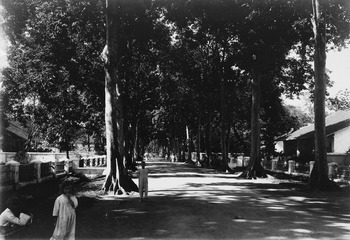
European children on the Heerenweg, Makassar, early twentieth century (Koninklijk Instituut voor de Tropen, Amsterdam, TMnr 60039498).

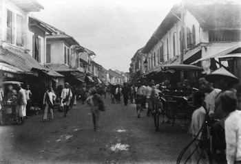
Chinese shopping street, Makassar, early twentieth century (Koninklijk Instituut voor de Tropen, Amsterdam, TMnr60039504).

The post-1847 customs regime furthered Makassar's integration into the China Sea trade based in Singapore (est. 1819) and Hong Kong (est. 1844), the very opposite of what the Dutch had intended.Footnote 26 Chinese immigration and investment surged. In 1828 Makassar counted about 19,000 inhabitants, including 1,500 Chinese, 714 Europeans, and 15,217 free natives, but by 1860 the Chinese and indigenous populations had doubled while the European community remained static; the 1870 figures confirm this trend (with 747 Europeans, 3,944 Chinese and 37,165 free natives). But European numbers started to grow, reaching 836 in 1896, and in 1905 it was estimated that Makassar's total population of 26,000 included 1,000 Europeans and 4,600 Chinese. By 1916 the former were thought to number 1,500 and the latter 6,900; both had again increased twofold by 1930.Footnote 27 Bureaucratic government required more Dutchmen, and now they imported their families. Social divergence increased as improved communications and political involvement intensified links with Europe and China while Sulawesi's Muslims became more oriented to the Islamic heartlands. The explicitly racist 1854 Colonial Constitution formalized differences between “Europeans,” “Foreign Asiatics,”Footnote 28 and “Natives,” and twentieth-century institutionalization, most notably of education, further hardened divisions.Footnote 29 Nevertheless, countervailing processes of creolization had forged cultural bonds, while later modernization in education and employment practice created common ground.Footnote 30 Kinship, religion, and class continued to crosscut categorizations and integrated groups that were theoretically separate, just as later they divided the officially united citizens of Indonesia.
By 1872, the identities of Makassar's old urban wards had been blurred by growing populations, immigration, and ethnic amalgamation. North of the fort, where communal officers controlled relatively stable quarters, the VOC structure still worked, but the southern, predominantly Indonesian settlements acquired a more bureaucratic, unified administration. Salaries were to replace labor services, fees, and gifts.Footnote 31
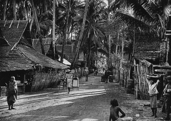
A Makassar Kampung, c. 1910 (Koninklijk Instituut voor de Tropen, Amsterdam, Mnr 60018562).

By 1921, “modern developments and the increase in all races and nationalities” had largely dissolved “customary ties,”Footnote 32 and the Company's old inner-city Asian quarters became two districts under paid officials. Chinese and Arabs, more alien and autonomous, retained their own non-territorial leaders.Footnote 33 Institutionalized public access to policy-making had only begun early in the century, and even then participation was communally organized and extremely limited. Nonetheless, as the population, commerce, government, and services expanded and diversified, social differentiation and even settlement was increasingly, if unofficially, organized along lines of status and income rather than ethnicity.Footnote 34 Within the small, educated middle class some recognized the possibility of a shared and equal membership in the urban community, at least in the work sphere.
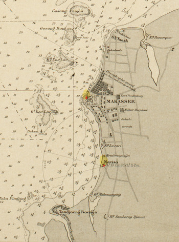
Detail from 1898 Map. Karebosi lies under the “Mak” of Makassar, while Losari is indicated north of Mariso.Footnote a

Since the early 1900s, several variations of belonging had infused nationalist discourse: ethnicity, reflecting language and region; the ideal of a citizenship based on birthplace and allegiance; and the notion of an “Indonesian race,” primarily defined in opposition to Europeans and Chinese. This last prevailed, and “racial” distinctions deepened while intra-Indonesian “ethnic” boundaries weakened.Footnote 35 Although, in theory, decolonization ended communal distinctions, when nationalism was conflated with religion it encouraged antipathy towards non-Muslims, including, frequently, Chinese. By the time of the New Order of the later twentieth century, race and religion were such sensitive issues that their discussion was prohibited.Footnote 36
The Japanese had (re)incorporated the city into peninsular and national politics in 1942. This was confirmed with independence, and constituted a dramatic rupture in Makassar's public life. An essentially Sino-Dutch urban economy became subject to Bugis-Makassarese politics. Before 1860, the relationship between Makassar and the peninsula's main polities was, at best, one of armed neutrality, and even after all South Sulawesi was finally subjugated in 1906, the apolitical colonial regime insulated the city from the “native states”; the Sulawesian urban elite was weak.Footnote 37 This relative separation collapsed with the 1949 transfer of sovereignty to Indonesia. A decade later, the nationalization of European enterprises ended direct Dutch influence and triggered large-scale emigration. Chinese numbers continued to grow, but their community was stigmatized.
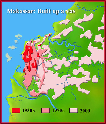
Makassar's population had grown dramatically during the 1940s; if in 1930 the total was around 84,000, it had more than doubled by 1949.Footnote 38 Then, after 1950, South Sulawesi's instability generated waves of refugees that further overwhelmed Makassar's relatively unskilled and desperately under-financed administration. The non-military population in 1950 was an estimated 161,546, including 6,795 Europeans (virtually all of whom left over the next decade), and 31,026 Chinese. The total had more than doubled by 1960 to 384,159. Resulting problems led the energetic mayor Patompo in 1971 to increase the urban area from 2,140 hectares to 17,577, which raised the number of inhabitants from 421,131 to 570,706. By 1988 they totaled 821,957, and in 2010 exceeded 1,300,000.Footnote 39 The land acquired in 1971 was largely rural, but over the next decades extensive new suburbs developed to the east, some planned, others spontaneous. Ramshackle buildings filled the space behind the brick bungalows that lined the better streets. The old city lost population. Development could not keep pace, and despite dramatic growth since the 1980s, poverty remains a harsh reality.Footnote 40
Postwar political rhetoric emphasized the common people's rights, but although Java's leftists mounted a strong, if disastrously unsuccessful campaign against entrenched classes, South Sulawesi's “anti-feudalism” was more limited, and many aristocrats translated established prestige into powerful new positions. Makassar became more provincial and Europeans and Chinese left or were pushed aside, weakening international connections.Footnote 41 Sulawesian army officers, well-born politicians, and Muslim entrepreneurs (roles sometimes combined in one person) competed and cooperated, showing remarkable, if covert continuity in basic patterns of rent seeking.Footnote 42 Whereas profitable monopolies were once auctioned by the state, now cliques and cronies divided the spoils informally. Elite convictions of entitlement encouraged personal appropriations and ignoring of the law. Public demands for accountability only began to have an effect after 1998.
The Growth of Makassar, 1920–2000.Footnote b

In 1965, Sukarno's populist Old Order was removed by Suharto's military-backed New Order, which was itself replaced in 1998 by the more open era of Reformasi. National governments continued to be Java-based, requiring mutually advantageous ties between Jakarta and Makassar elites. Popular sentiment, however, has always favored regional autonomy, which encourages local politicians to emphasize the natural dominance of Muslim Bugis and Makassarese, with Javanese “imperialists,” Chinese immigrants, and Christians considered outsiders.Footnote 43
By the early 2000s, rapid development had become contentious, with opposition galvanized by decisions to develop Karebosi and Losari. Both had remained attractive central spaces with open access, and they were also the main inner-city sites where the poor could earn a living in the informal sector by running food stalls or peddling cigarettes, magazines, and patent medicines.Footnote 44 Consequently, there were confrontations between municipal governments bent on imposing order and people seeking escape from it.Footnote 45 Both spaces had long histories, but while Losari was primarily a site of relaxation, Karebosi had deeper and more significant roots.
Karebosi and Losari before 1950
Karebosi
According to local tradition, Karebosi field, like many of the most potent places in South Sulawesi, is charged with divine energy; it was one of the sites where sacred beings or tomanurung revealed themselves.Footnote 46 According to the story, around 1300, when Gowa was riven by conflict, Karebosi was still a dry field. But then it stormed for seven days and seven nights, the ground split, seven grave-like earthen mounds appeared, and from each emerged a figure dressed in shining gold. These beings then vanished in the rain, leaving behind piles of earth, a spellbound population, and fertile terrain. These mounds became known as the Tujua (Seven) and the visitors as Karaeng Angngerang Bosi (the lords who bring rain); hence the name Kanro Bosi or Karebosi, indicating a place provided with water through divine intervention.Footnote 47
Another Karebosi tale describes the defeat of evil jin (spirits) by the three learned Malay ulama who brought Islam to the courts of South Sulawesi in the sixteenth century. Three jin rulers, masters of the black arts, established a reign of terror throughout the island. They were intrigued to hear of the benign spiritual power attributed to the ulama and challenged them to a trial of strength at Karebosi. The jin were defeated and banished to the mountains, freeing Karebosi of malign influence.Footnote 48 More historical accounts also emphasize Karebosi's beneficence. It was once a sacred rice field, where the Gowa ruler initiated each planting season by setting a plough in the earth. Then, in order to ensure a good harvest, a ritual dish of newborn mice was consumed, before the court retired to nearby Bontualaq for cock fighting and feasting.Footnote 49
During the VOC period, Karebosi remained under the Bugis, extending south of the Hogepad (“High Path”) linking Fort Rotterdam and Bontualaq.Footnote 50 In 1695, rulers from all over South Sulawesi were summoned by the Bone king to pledge their loyalty to the Company:
The entire field of Bontoala was covered with armed folk, … some twenty-five thousand men, arranged in such good order and rows … under a multitude of banners, pendants and standards.… The Golden Umbrella … representing the standard of Bone, … hung with gold chains, was brought to the army by the cavalry, … provided with yellow saddles and new chain mail.… The various kings and princes … in turn … threw their shields down and stuck their lances into the ground … they quickly unsheathed (their swords) … and sprang up into the air with passion and fury … declaring that they would remain faithful to the Company and live or die with it.… Extraordinarily splendid was the whole spectacle, and those of Bone shone above all others.… The most important kings swore their oath of loyalty while the cymbals, the clarinets and the gongs played, and the bystanders clapped their hands to the beat and the sound of the music.Footnote 51
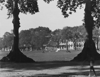
After 1814, much of Bone's Makassar domain was incorporated into a long military buffer zone that separated settled coastal areas from inland Sulawesian territories. The Koningsplein (the King's Plain), or Karebosi, lay in the northeastern corner.Footnote 52 Most Dutchmen still clustered close to the fort, and in 1860 a visitor commented that there were only about twenty isolated houses by the “great plain.”Footnote 53 After Bone's defeat that year, it became safer to live further inland. New priorities soon emerged. During the 1870s, a massive prison was constructed on Karebosi's north side,Footnote 54 and by the 1890s rows of spacious villas displayed an increasingly confident Makassar. The area between Fort Rotterdam and Koningsplein became the center of colonial government,Footnote 55 and the late twentieth century saw surrounding streets lined with banks and offices. Karebosi itself remained largely unchanged: eleven hectares of simple sports fields in the city's heart.Footnote 56
The Koningsplein: Colonial Karebosi (Koninklijk Instituut voor de Tropen, Amsterdam, Panorama Plein TMnr 60008253).

Losari
Until the 1930s, the Makassar government showed little interest in the coastline. Before the mid-nineteenth-century arrival of steam shipping Makassar's maritime trade was governed by the monsoons, which also influenced residential patterns. Strong winds and high waves battered the shore at the height of the west monsoon in January and February, and caused erosion and flooding that discouraged investment in seafront settlement.Footnote 57 Consequently, trees and kampung dominated the littoral, with better housing clustered further back. Yet privileged Dutchmen were not impervious to the charm of the sea breeze, and in the late seventeenth century the governor established an “outside” residence named “Thuyn het Loo” about half an hour south of the fort. There, he and his family could escape the heat, noise, and stench of his official home in the castle. Later governors’ had a seaside “place of pleasure” still further south at Mariso.Footnote 58 In the early nineteenth century both of these estates passed into private hands, the former acquired by various elite mestizo families, the latter alternating between Chinese and mestizo owners. The wealthy slave trader Alexander de Siso owned “het Loo” in 1819, and in 1825 the estate, now known as Losari, was described as a “pleasant rural residence.”Footnote 59
De Siso was buried at Losari in 1832, and the obelisk marking his grave became such an important landmark for incoming sailors that in 1857 the government undertook its maintenance, on the condition that the property's then-owner, the prominent mestizo shipper J. G. Weijergang, agreed to protect it. By the 1870s, Losari was a well-established coconut plantation with a complex of buildings and its own jetty, bordered by rice fields to the south and east. To the north lay the smaller Arendsburg estateFootnote 60 and Kampung Bessi, where former inhabitants of Kampung Dompo had been resettled in the early nineteenth century after their seaside village was destroyed by storms.Footnote 61 By 1916, Losari's neighboring rice fields had been replaced by kampung and coconut groves, which came under pressure as the city expanded further south; in 1919 a housing complex for over a hundred families of lower-level municipal employees was constructed inland from the Losari coast.Footnote 62 But real change began in February 1929 when waves swept away Losari's coastal kampung, which led the government to build a protective sea wall and short stretch of beach boulevard. Further inland, a new road parallel to the coast, Bessiweg (now Jln. Lamadukalleng), bisected Losari, and this stimulated suburban development on the seaward side.Footnote 63 The dualistic development typical of Makassar (and most colonial towns) was clearly visible by 1938. Neat streets lined with modest European villas branched west of Bessiweg, while the inland kampung remained so poor and dilapidated (and so strategically located) that the city government was considering their removal.
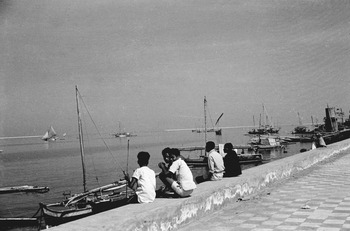
View from the Makassar Seawall, late 1940s (Koninklijk Instituut voor de Tropen, Amsterdam, TMnr 10029316).

The safety and prestige of a waterfront location was confirmed when two modern (1938) houses proved able to weather the west monsoon. One was the new official residence of the mayor of Makassar. By then, Europeans associated the seashore with pleasure rather than danger, and sailing and swimming feature prominently in colonial recollections.Footnote 64 Although the threat of war encouraged municipal authorities to extend coastal control in the late 1930s, Mayor H. F. Brune (1936–1940, 1945) seemed more interested in urban renewal. New regulations were drafted that enabled the city to acquire seaside land and so implement the “decades old” idea of lengthening the seawall. A new beach boulevard was planned to run some 1,250 meters from just south of the fort to Losari. The Japanese occupation from 1942 to1945 interrupted Brune's plans, but after the war he extended the short 1929 seawall up to the fort, creating a new coastal road. This later became Jln Penghibur (Entertainment Street), renowned as Losari.
Brune also had an opportunity to reorganize the oldest part of the city, since Allied bombing had destroyed over a thousand buildings around the port and in the Chinese quarter. Ambitious renewal plans were announced in 1946.Footnote 65 Losari was one of the areas considered suitable for middle-class settlement. Government rights had already been established, and the idea of replacing existing kampung with better—that is, Western—housing predated the war. Brune had observed then that this would require “patience and considerable tact.”Footnote 66 The transfer of sovereignty in 1949 terminated the Dutch plans, but their Makassar legacy confirms that modern suburbia remained their priority. Most of the reconstruction in Asian quarters was spontaneous, and often proceeded on land officially owned by others, mainly Europeans.Footnote 67
Development had been relatively easy for the Dutch because they claimed ownership of most land by right of conquest.Footnote 68 Although new administrative institutions, organizations, and media began to expand civic expression in the early twentieth century, these were heavily biased in favor of the privileged. After a 1903 “Decentralization Law” opened the way for local government, a Municipal Council was introduced in Makassar (1906). Initially all members were government appointees, prominent figures represented their ethnic communities in a manner reminiscent of the VOC's officer system. The chairman was an administrative official. After 1917 council members were elected by ethnic groups, and the next year the first mayor was appointed. Urban management became more ambitious. Although Makassar's first building ordinance of 1918 applied only to European quarters, the Indies 1924 town planning regulations established official responsibility for whole cities. Despite their limitations—in 1938 less than 4 percent of Makassar's population could participate in urban elections—the councils provided crucial experience in multi-ethnic urban politics.Footnote 69 After independence new notions of entitlement raised expectations, but the straitened circumstances of the 1950s and 1960s prevented significant development.
Makassar's Waterfront
Of all Makassar's mayors, Muhammed Daeng Patompo (1964–1978) and Ilham Arief Sirajuddin (2004–2008, 2009–present) most clearly left their mark, and only they have achieved a second term. The procedures through which they were selected reflect the changing times: Patompo was chosen by the municipal council, while Ilham was the first mayor elected by direct popular vote, in May 2009.
Patompo was born in 1926 in Polmas, South Sulawesi. The son of a pious trader of aristocratic background, he became an army officer, was seconded to Makassar's administration in 1961, and became mayor in July 1965. With the help of foreign aid and lottery money he created satellite suburbs, streamlined traffic, embarked on kampung-improvement programs, and re-christened Makassar “Ujung Pandang.”Footnote 70 He also planted palm trees along the Dutch sidewalks at Losari. Patompo had backing from the army and was well liked, but despite his efforts poverty grew and modernity remained a distant hope.Footnote 71 Twenty years later different priorities governed urban investment, and Indonesia's government was widely regarded as corrupt. Collusion of Chinese capitalists and indigenous officials was popularly seen to be the New Order's rotten heart, and in fact whole sectors of the economy were bought and sold to the detriment of the inhabitants. Property deals were particularly poisonous and came to be associated with dispossession, inadequate or embezzled compensation, and contempt for both human rights and the environment. Any government-sponsored initiative that seemed to favor Chinese developers inflamed racist emotions. Makassar was no exception,Footnote 72 and after 1990 Chinese involvement in ambitious plans for waterfront redevelopment heightened ethnic tensions, which culminated in particularly violent riots in 1997.
On 5 December 1990, the Gowa-Makassar Tourism Development Centre (GMTDC) was created to build a new coastal township, Tanjung Bunga, on a thousand hectares round the mouth of the Jeneberang. The GMTDC, “The Pride of Makassar,” combined government and private investment, and epitomized the murky links between politics and capital.Footnote 73 Forty percent of the terrain was to be open to the public, with the rest allocated to tourism (35 percent), commerce (10 percent), housing (10 percent, including low-cost units), and education (5 percent). Hotels, a golf course, an artificial lake, a convention center, three office towers of between sixteen and twenty-two stories; it all looked wonderful in the promotional material.
At some point the Lippo Group, a well-known, even notorious conglomerate controlled by the ethnic Chinese Riyadi family, was invited to participate.Footnote 74 At first their role was limited, but by 1995 they were highly visible and attracting unfavorable comment. The usual problems occurred: people settled in the area refused to be relocated, and Makassar's environmental officer struggled to protect the precarious coastal ecology. All objections to the project were quashed. The threat to the shoreline became even more obvious with plans to build a road 1.5 kilometers long and 60 meters wide from Tanjung Bunga to the southern end of Losari. Although this entailed extensive landfill that would create an enclosed lagoon, complaints were dismissed on the grounds that this was not land reclamation but only routine road works, and Jl. Metro Tanjung Bunga was duly completed. In January 1996, more controversy erupted when it was revealed that the so-called “social housing,” which had replaced the planned tourist complex (of about 250 hectares), had not been sold on the open market. Most of the inside buyers were said to be Chinese, including many from the Lippo Group itself, and people complained, “Later Tanjung Bunga will become a new China Town, an exclusive settlement for those of Chinese descent.”Footnote 75
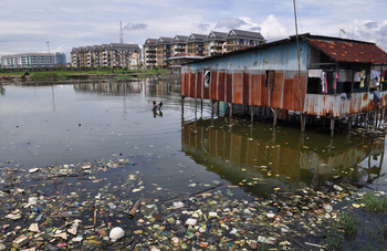
Mariso, Makassar, February 2011. Fishermen squatters occupy shacks, awaiting legalization, while new developments at Tanjung Bunga (background) offer limited cheap housing (TEMPO/Kink Kusuma Rein).

For the Lippo Group, Tanjung Bunga was an opportunity to repeat a successful formula, and their website pitched the plans accordingly: “Over the years, Lippo Karawici has set the pace and standard in the design, construction, marketing and sale of quality-built homes within integrated lifestyle communities in Indonesia. Targeted specifically to the middle- and upper-income group segments, our residential developments have nevertheless set the benchmark for high quality homes….”Footnote 76 This profile of Tanjung Bunga was very different from the initial descriptions, which had emphasized public access and tourism. Under the New Order, such profitable opportunism was protected, but when that regime ended public opposition became overt. Reformasi had created a climate in which the public expected to be heard, and media, students, NGOs, religious leaders, and academics all now felt free to criticize the city administration, often focusing on persistent poverty.Footnote 77 Nonetheless, urban planning seemed geared toward prosperous consumers, leaving the common people to struggle for survival. This fuelled bitterness, particularly when decisions were tainted by the hated KKN—”korupsi, kolusi dan nepotisme (corruption, collusion, and nepotism)”—associated with Suharto.
By early in this century, Makassar's public sphere was decidedly lively. There were many different voices, but they tended to articulate one of two dominant, legitimizing ideas: one stressed the virtues of large-scale development, while the other emphasized equity in defense of the “warga Makassar,” a morally loaded term referring to citizens, members of the Makassar “family.” Advocates of the former used the techniques and imagery of modern marketing to sell the idea of an international, consumption-based good life; proponents of the latter pointed to the dangers of untrammeled capitalism, particularly the inevitable marginalization of the weak, and the threat to local identities and religious values. This confrontation echoes the worldwide debate on “globalization,” but here it also expresses deeply rooted local suspicions of elite assumptions of entitlement.
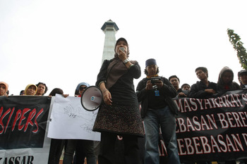
Demonstration against government attacks on freedom of the Press, 21 November 2009, at the Monument commemorating the Liberation of West New Guinea, Makassar (Kompas Antara).

The effects of Reformasi are clear in a 2007 publication in which officials from Makassar's city government reflect on the town's past, present, and future.Footnote 78 Remarkably, they address not only the benefits of rapid development, but also its problems. They reiterate the slogans of local boosterism: the “branding” of the city as “Makassar Great Expectation,” and its “repositioning” so it will not be just the “gateway” to east Indonesia but also its “living room.” The officials describe the campaigns to encourage reading and to create wireless corridors (“Makassar Cyber City”), and tout Makassar's planned transition from “Metropolitan” to “Megapolitan” status. But they are also ambivalent, and cite an anonymous senior official who says that he has seldom seen fine plans realized in practice (p. 214). They plead: “Don't let development increase the suffering of peripheral people, or marginalize small entrepreneurs, or make it increasingly difficult for people to enjoy their rights as members of the urban community” (211). Elsewhere (209) they note: “Alongside this rapid development, various problems are asserting themselves in Makassar. Increases in unemployment and poverty, a lack of control over the informal sector, environmental and social degradation, all demand solutions. Makassar's expansion raises the question, what will Makassar be like in the future? What sort of Makassar do we wish to leave to our descendents?”Footnote 79
Before 1998, such skepticism would never have been expressed in a government-sponsored publication. New Order officials expected to be obeyed, and fear and a sense of hierarchy ensured that they were, but Reformasi politicians required new skills. Ilham Arief Sirajuddin, Makassar's mayor since 2004, has these in abundance. He seems destined to rank alongside Patompo in his impact on the city, but after almost half a century, Indonesia is a changed country, and Patompo and Ilham came from very different backgrounds. Ilham is an urban professional groomed for success, a child of New Order privilege. He was born in Makassar in September 1965, son of a two-term bupati (regional head) of Gowa, and is Makassar-educated.Footnote 80 His business activities and support for the government party Golkar have helped his career, as has his interest in the popular local PSM football club (founded in 1915 as the Makassar Voetbal Bond). In 2011 he had his own Facebook page and an on-line fan club. Ilham is in every respect the modern politician, presiding over the city during a time of rapid economic growth and impressive investment. His ambition has been to remake Makassar into a business-friendly, service-oriented, and strikingly modern city.Footnote 81 When appointed in 2004 he was Indonesia's youngest mayor.
Mayor Ilham planned to make Losari into Makassar's trademark, and as soon as he came into office he persuaded President Megawati to inaugurate a “Save Our Losari” campaign.Footnote 82 Unlike the tycoons of the GMTDC, Ilham seemed more interested in improving public amenities than making big money. The waterfront was run-down and polluted, with the seawalls in poor condition and city drains carrying rubbish and untreated sewage directly into coastal waters. Concentrations of heavy metals made local seafood unfit for human consumption. Ilham decided to reclaim roughly eleven hectares at Losari, which required moving six hundred thousand cubic meters of fill. Public parks and promenades had priority, with 30 percent of the space marked for road widening and parking. Three new “platforms,” or piers, were to be built out into the sea and would provide welcome breathing space. These plans had by 2006 been partly realized with the first semi-circular “platform” (pelataran Bahari) finished. The hawkers who had once lined the beach had been forcibly relocated as part of a plan to extend the waterfront to a total length of five kilometers by using land along the Tanjung Bunga causeway.Footnote 83
By 2008, plans for Losari incorporated “Centre Point Indonesia” (CPI), a complex of some 157 hectares that included a plaza, a diplomatic village, a beach boulevard, a people's hall, a monument to one thousand nationalist martyrs, and a floating mosque. But there were severe financial constraints owing to limited government funds and private investors' lack of interest. In July 2009 an Internet correspondent raised a question that must have been on many peoples' minds: “Extending Losari Beach and the CPI: Just an Official's Obsession?” Indeed, the plans for the site seemed to be in inverse proportion to the funds available to carry them out.Footnote 84 Tanjung Bunga remained a better financial bet. While the Losari project struggled for lack of funds, Makassar's other iconic site, Karebosi, was generating tension due to Chinese investment there.
Contesting Karebosi
By the mid-twentieth century, Karebosi was inner city Makassar's only large open space. Dutch engineer D. N. Meyer wrote in 1948, “Construction around the Koningsplein [Karebosi] deserves further attention. In my opinion this space should be seen as the center of city life, where the people come together on special occasions to be addressed by their leaders, or to celebrate the Pasar Malam fair or other festivities. This role makes specific demands on the built surroundings, which should be lively. For that reason any concentration of government buildings around the Koningsplein should be discouraged.”Footnote 85 Meyer had identified Karebosi's essentially ambivalent role: it was a space for popular pleasure seeking, but also a site intended to express political power. It was the natural location for election rallies, religious meetings, political demonstrations, and inaugurations, but also where people went to play football, visit food stalls, and pass the time of day or night. But Meyer's ideas were overtaken by events.
Postwar Indonesian administrations had more pressing concerns, and so Karebosi remained an undeveloped open field. During the second half of the century, however, surrounding streets came to be dominated by banks, particularly on the northern side. This was a sign of things to come, just as the building of the prison there in the 1870s had marked a shift from military to civilian priorities. By early in this century, this prime real estate was drawing the attentions of both the city administration and private investors. The former was ambitious and under-funded, but owned large tracts of urban land, while the latter were well aware that property development offered a high chance of profit at, given government involvement, low risk. Karebosi became a target for urban renewal. News that a private company was to lease and exploit the square sparked an explosion of public protest, an outpouring that would have been impossible under the repressive New Order but was now permitted and even encouraged in the more open and competitive political climate after Reformasi.
Mayor Ilham envisaged a “revitalization” of Karebosi as well as Losari. But, as had become clear with Losari, there was simply not enough local money to fund such ambitious projects. Development on that scale had to draw from Jakarta, where big entrepreneurs were embedded in the highest political circles. Commercial incentives were necessary, so the “New Karebosi” included an underground shopping center and extensive parking facilities, including blocks earmarked for neighboring banks.Footnote 86 In return for this partial, and, Ilham stressed, temporary privatization, he promised better (albeit fewer) sports facilities, less dust and flooding, increased town revenue, and more jobs.Footnote 87 But the Makassar public recalled a history of development plans that had promised improvement for the many but merely enriched the few, and were skeptical. Given Makassar's increasing congestion, Karebosi's planners had good reasons for emphasizing traffic flow and parking, but their favoring of automobiles over food stalls and football seemed to indicate that the common people were being marginalized.
In June 2007, a Makassar-born, Jakarta-based blogger posted his reaction to Ilham's plans:
I don't know when I last went to Karebosi, the pride of our city … but I remember we used to hang out there, attend independence day ceremonies, or visit it for school activities, or games, or just drop in. I don't really know anything about its function, its history or blah-blah. But I do know that Karebosi was our pride. It was kilometer zero of Daeng City [Makassar].… Why does it have to become shops? Why a mall? … Honestly, I would prefer to see Karebosi as it is now, surrounded by food stalls, school kids passing by, children playing football and buying local snacks, a pedicab driver curled up asleep in his becak. It's easy to see why this transaction, this buying and selling, has generated such sound and fury.Footnote 88
This echoed the equally emotive if more formal response of city officialsFootnote 89: “Karebosi, the second icon” [of Makassar, after Losari] is “where people construct their own worlds through various routines. Beginning with the sound of political speeches in the campaign season, with the flashing feet of PSM players managing the ball, with the noise of music shows.” The authors are ambivalent; they acknowledge that Karebosi's renovation would serve as “clear proof of the city government's concern to provide better care for the citizens of Makassar,” but continue:
At the moment Makassar is developing so rapidly that it is feared that Karebosi's public function will be lost completely. If Karebosi is also incorporated into the privatization wave of metropolitan development, then Makassar will become a city that is no longer friendly to its citizens. The amiable bustle of the city will change, caught in the world of consumerism, there will be no more smiles for its citizens, no more small children playing in the field in the morning, accompanied by the sound of birds.… (T)his is a very subjective assessment, but collective feelings like these represent the spirit of Makassar's people.Footnote 90
The mayor's “revitalization” was opposed by a coalition that included students, the press, NGOs, and representatives of local custom (adat) from Gowa and nearby Maros, but his plan also attracted support. Doubts were based on concerns about public access and environmental impacts, but also on Karebosi's special character. In December 2007 the head of the provincial office for cultural affairs and tourism stated that since Karebosi was an historic site, plans were subject to approval by the relevant authorities. The government dismissed the claim: the Tujua, the seven empty graves commemorating the tomanurung, were not protected.Footnote 91 Nevertheless, their informal but controversial sacred status was invoked by both those for and against redevelopment.
Both sides organized demonstrations during the second half of 2007. Top officials and academics got involved, and a citizens' lawsuit was filed to block the project (but was rejected by the courts).Footnote 92 Students united with conservatives (members of the Komunitas Lembaga Adat se-Sulawesi Selatan, or All-Sulawesi Community of Customary Institutions). Wearing traditional dress and claiming hereditary membership of the old Gowa and Talloq kingdoms, hundreds of demonstrators gathered at Karebosi and performed rituals before proceeding to more modern forms of action, tearing down the fences surrounding the site. The police were not impressed by the argument that the swords and spears many carried were purely ceremonial.Footnote 93
On 11 November 2007, a prayer service was organized at Karebosi to ensure that “revitalization” would not be disturbed by “either people or supernatural creatures, as for centuries it has been believed that Karebosi has been haunted by subtle beings, such as jin and other spirits.”Footnote 94 The service, which the media attended in mass, was intended to protect Makassar's inhabitants, but also to show that traditional authorities did not oppose the project. The list of attendees included not only military and civil officials but also leading representatives of the royal families of Gowa and Talloq, whose ancestors had once ruled Makassar, and these nobles duly endorsed Karebosi's redevelopment.Footnote 95 Many local Islamic leaders also favored the government, on both practical and moral grounds:
Apart from its recreational function, during the last decades Karebosi has been a place for superstitious rituals. Some citizens have been bringing offerings to the Tujua to seek their blessing. According to Islam this is a grave sin since it constitutes syirik, a belief in spirits. Moreover, some corners of Karebosi are centers of vice, such as gambling, or are frequented by prostitutes and transvestites, or are cruising areas for homosexuals.… Functions of health and disease are almost balanced [i.e., sports against environmental and moral degeneration]. During the day it is choked with dust, and at night full of “socially diseased” interactions and transactions.Footnote 96
In the new Karebosi, the Tujua are well-fenced, suggesting respectful protection, or, perhaps, deliberate isolation.
Inevitably, Karebosi became an issue in the mayoral elections of 2008. Ilham, standing again, ran on his record, which included substantial anti-poverty initiatives as well as a commitment to development. Losari and Karebosi were central campaign images.Footnote 97 On Karebosi, Ilham's slogan was “Once scorned, now praised!” Although he began the race as firm favorite, surprising gains were made by his chief opponent, whose platform included a promise to return Karebosi “to its original state.” In the end Ilham did win, and the development of Karebosi continues today, watched by a divided public.Footnote 98 Between 2007 and 2010 Karebosi was transformed; the northern half of the field is now dominated by a large pavilion that provides shelter for privileged guests at public events.Footnote 99 It seems that Karebosi's ambivalence, as sensed by Meyer, might be resolved in a victory of power over public pleasure.
Conclusion
For nearly three hundred years, until the mid-nineteenth century, Karebosi was a peripheral place, a strategic buffer zone between the Dutch fort and Bugis Bontualaq, controlled by Bone until 1814, and then by the European military. After Bone's defeat in 1860 defense priorities gradually gave way to settlement, and by the end of the century the streets around Karebosi were the city's most prestigious, lined with government offices and villas. Paradoxically, the open space itself remained the domain of the common people, an egalitarian place of pleasure.
Inhospitable Losari, subject to west monsoon storms, had before the 1920s been of little interest to Makassar's governors, and local village headmen supervised the seaside kampung. However, by the 1930s newly available technology, the post-1924 interest in urban management, and an expanding Dutch population had led to much of the central coastal strip being suburbanized. Although the beach boulevard drew people to enjoy the sunset and sea breeze, Losari's official development for public recreation was a largely postwar phenomenon. The explosive expansion of street-trading created the “world's longest restaurant.” When colonial rule ended, both sites were embedded within the Dutch-controlled inner city, but remained of and for the people.
Losari and Karebosi are not just public spaces; they have also always been open neighborhoods, shared by all who visit. Appadurai observes, “The work of producing neighborhoods—life-worlds constituted by relatively stable associations, by relatively known and shared histories, and by collectively traversed and legible spaces and places—is often at odds with the projects of the nation-state.” Many tourist locations fall victim to “the powerful tendency for local subjectivity itself to be commoditized, and the tendencies of nation-states, which sometimes derive significant revenues from such sites, to erase internal, local dynamics through externally imposed modes of regulation.”Footnote 100 Opponents of “revitalization” feared that Losari and Karebosi would be similarly appropriated, and they were outraged. A strong sense of popular entitlement had developed over the years, based on personal memories and knowledge of equal access, regardless of ethnicity, class, or religion.Footnote 101
As Makassar's area and population expanded, and ruling regimes changed, political control and social identification were consolidated. The former became more tightly integrated, direct, and impersonal, while a range of relatively flexible ethnic identities crystallized into fewer and harder racial categories (native, Chinese, European). Nevertheless, trans-communal alliances and the small middle classes found common ground in business and, later, in an emerging modernity. During the twentieth century, interventionist governments increasingly managed access to resources, including space, and under new methods of representation, interest and faction tended to outweigh custom. Patronage, personal networks, and a sense of elite entitlement remained crucial, but more covert. These broad trends were neither synchronized nor smooth; authoritarian regimes (colonial, New Order) were particularly resistant and political adjustments lagged behind social change. The long nineteenth-century project of administrative rationalization, the replacement of patrimonial by bureaucratic authority, was undermined by the persisting appeal of communal ties. During uncertain times, these provided useful means of mobilizing support and appealing for protection.
Both the colonial Dutch and Indonesian governments aspired to an alignment of space, identity, and political control, the former through the ethnic mosaic, the latter through citizenship. The Visman constitutional reform committee in 1940 concluded that nothing generated so much emotion “as the racial differences in law and society; social differentiation was more grievous than legal.”Footnote 102 Race and ethnicity dominated colonial social discourse; class was self-evident, but implicitly regarded as operating within separate communal arenas. Fixed categorizations denied the traditional heterogeneity of creole families, the converging lifestyles of the tiny middle class, and the fact that although the kampung shared by the poor had ethnic names their inhabitants remained varied.Footnote 103 Officially, race still trumped class, but those with the cultural skills to operate within modern institutions wanted a place at the table, where cross-cultural negotiation could shape events. Both the advancing uniformity and sharpening division noted by Bayly were apparent.Footnote 104 During the 1900s, nationalist and, more cautiously, egalitarian ideals began to stigmatize difference, while Islam and the idea of a common Sulawesian identity enhanced native solidarities; Europeans were the enemy, and Chinese increasingly excluded. The ideal of unity was in fact divisive, encouraging discrimination particularly when perception fused class and race.
Over the course of the twentieth century, privileged groups from all communities developed similar tastes and sought similar ways of living that were very different from those of the majority. Residential segregation was increasingly determined by income, status, and preference. Civil servants and employees of large institutions tended to live in specially built housing complexes. Most Chinese businessmen continued to favor shop-houses, unlike other entrepreneurs, including Arabs and Indians, who separated work and domestic life, and the very rich of all communities, who moved to new suburbs.Footnote 105 Writing of Makassar in 1976, after more than three decades of Indonesian independence, McTaggart commented: “The texture of the urban environment includes both permanent and ephemeral forms of construction, both established road or street patterns and informal networks of paths or tracks, reticulated water supplies and individual wells. Dualism, evident in all aspects of this texture, whether in the forms of buildings and infrastructure, or in forms of economic organization, might be compared with pre-European Makassar, with its aristocracy and commoners, its permanent forts and insubstantial kampung housing.”Footnote 106 For McTaggart, this dualism was essentially material in that the priority given to “Dutch, Chinese and elite Indonesian areas” was determined by self-interest and the ability to pay.Footnote 107 By the 1980s the wealthiest members of all communities were moving to large fortified villas in up-market suburbs. Class divisions became even more obvious.
Furnivall believed that plural societies were inherently unstable: united only by the market, they lacked a “common social will,” an integrating moral economy. In these political systems, held together by force, “natural social orders” degenerated, assumptions of entitlement overrode law, and nationalism heightened conflict.Footnote 108 Indeed, the plural society of Dutch Makassar was very much man-made and state-maintained, and after 1942 it disintegrated. And yet, though Indonesia's independence had in theory abolished old communal identifications, here, as elsewhere, “the common social will” was shaped by elite privilege and popular prejudice. Europeans and mestizos left or were dispossessed, many Malays and Muslim Chinese found it politic to assume a local Islamic identity, and most Chinese—including those born in Indonesia—faced formidable difficulties in claiming citizenship.Footnote 109 However, the 1997 riots forced Makassar's government and people to recognize the need to bring the Chinese into the city's moral community. Ideas of fairness, with echoes of Old Order ideology, began to surface, particularly among NGOs.
By the end of the twentieth century, Makassar's administration was seeking new ways to attract the tourist dollar (or euro). “Re-branding” required a suitable historical profile. In 1999, after twenty-eight years of “Ujung Pandang,” a highly symbolic change of city name reinstated the internationally recognizable “Makassar.” Ujung Pandang was deemed too parochial, albeit for varying reasons. Some, including those in city government, felt it reflected the narrowing of horizons that had accompanied postwar emigrations, foreign company nationalizations, and immigration from the interior, while others, more chauvinist, believed it failed to project the specific glories of Makassar's “heroic and romantic” past.Footnote 110 A city museum was opened in the old Municipal Council building, and the quest began for that indispensable attribute, a hari jadi, or birthday. Rejected options included the colonial (the 1906 designation as municipality), and the religiously and ethnically sensitive (the fourteenth-century descent of Gowa's founding tomanurung). In 2000 the date of Gowa-Talloq's conversion to Islam in 1607 was selected,Footnote 111 emphasizing Makassar's place in the international ummah, or Islamic community. The new image was of a Muslim yet multi-ethnic global city.
As early as the 1980s it had been proposed that Makassar's diverse cultural traditions be commemorated by a designated historical quarter, “Makassar Tempo Doeloe.”Footnote 112 This produced little more than iron streetlights illuminating the crumbling roads. Fifteen years later, when Mayor Malik Basry revived the idea and suggested a Chinatown, his timing was against him. But after 1998 Jakarta repudiated anti-Chinese policies, and in any case Makassar was anxious to heal post-riot rifts; in February 2003 an ornamental entrance was ceremonially opened that proclaimed, “China Town: Gateway to Indonesian-Chinese Brotherhood.”Footnote 113 Forty-four hectares of old Makassar, the VOC's Vlaardingen, officially received a new identity, a spatial re-designation that recognized the Chinese role in Makassar's history as legitimate, if apart. Like all multi-ethnic models, this one freezes typologies and ignores contrary social trends, including residential segregation's aggravation of anti-Chinese feeling, and the middle-class tendency to live in mixed Chinese and Indonesian satellite suburbs.
In Makassar, wealth and poverty had always undermined ethnic spatial segregation, as both rich and poor sought appropriate housing. But the later-twentieth-century commoditization of space intensified tensions since many regarded the Chinese as rich outsiders, less entitled than native sons, and so race- and class-based anger fused, focusing on a perceived threat to public space. Such places are valued; they create community, and the pleasurable freedom of Karebosi and Losari had come to symbolize Makassar's common identity. The emotional reactions to their “revitalization” revealed conflicting aspirations: some saw welcome modernization, others felt these icons had been hijacked to serve the elite's shallow consumerism. The poor, like old beliefs, seemed unwelcome. Makassar's citizens are well aware that the fate of these sites could foreshadow the future character of their city.