Pueblo Grande de Nevada, often colloquially referred to as Lost City, is an Ancestral Puebloan (Virgin Anasazi) village located in the Overton arm of Lake Mead National Recreation Area (LMNRA). Positioned along several miles of emergent shoreline, the sites associated with this prehistoric village represent some of the densest and most diverse archaeological resources in the recreation area. Initially recorded by archaeologists in the early 1920s, the village was ultimately flooded due to the construction of Hoover Dam and the impoundment of Lake Mead, inundating low-lying habitations and isolating others on high ground. Today, extended drought conditions, with a concomitant decline in water levels, have completely exposed the 5 km long complex to foot traffic, dispersed recreation, and other land-based activities.
Whereas this archaeologically sensitive landscape is now open to general use, the recent exposure allows for renewed archaeological research throughout the entire Pueblo Grande complex—something that has not happened since the completion of Hoover Dam. Recently, a number of related archaeological investigations were conducted by the National Park Service (NPS), in partnership with the University of Nevada, Las Vegas (UNLV). These efforts included the collection of field-based data and observations on lake-related effects on prehistoric loci. The purpose of this article is to summarize observed lacustrine effects as a result of inundation and emergence at loci associated with Pueblo Grande de Nevada. What are the processes most likely to damage archaeological sites and, conversely, what are those that may serve to preserve and protect them?
The article begins by summarizing what is known about Pueblo Grande de Nevada and its physiographic setting. This is important because lake-related impacts to the village cannot be properly understood without some basic idea about its material culture, topographic setting, and geology. Next, direct and indirect effects caused by the lake at sites documented as a result of recent large-scale inventory are discussed. These observations include findings obtained from limited test excavations at emergent sites on the valley floor. The article concludes by summarizing how lacustrine effects have impacted architectural components at Main Ridge, the densest concentration of households at Pueblo Grande village.
INVESTIGATIVE METHODS
Between 2006 and 2008, nearly 405 ha (1,000 acres) of land associated with Pueblo Grande were inventoried in seven separate parcels (Haynes Reference Haynes2008). Each parcel was selected based on different criteria, of which the most important for this investigation were (1) survey in previously submerged zones to assess the potential for finding archaeological sites, (2) survey along ridges to determine how shoreline processes affected archaeological sites, and (3) survey on ridge tops above the lake highstand to locate unknown or previously excavated habitations. As a result of this fieldwork, the direct (e.g., sedimentation, wave action, shoreline development, and erosion) and indirect effects (e.g., tamarisk growth, aeolian processes, modern human activities, and cattle) caused by inundation and emergence at 29 prehistoric sites and one historic European-American site were documented and evaluated.
Following the inventory, test excavations were conducted at three sites on the valley floor previously inundated by Lake Mead (Haynes Reference Haynes2009). These sites included the two largest pueblos excavated by archaeologists at Pueblo Grande village in the 1920s—House 46 (26CK8411) and House 47 (26CK7592)—and a European-American faux pueblo (26CK6759). Stratigraphic findings from each of these sites proved relevant for allowing greater interpretive detail regarding lake-related processes observed at the archaeological sites recorded during inventory.
In conjunction with the inventory and test excavations, a systematic condition assessment of all architectural features still present on Main Ridge was conducted (Harry and Osborne Reference Harry, Osborne and Harry2008). In the 1920s, archaeologists identified 47 individual architectural components and produced a topographic map that included the location and general floor plan of each room block (Harrington Reference Harrington1927; Shutler Reference Shutler1961:Plate 25). During the 1980s, UNLV's Margaret Lyneis (Reference Lyneis1992:Figures 7a–7t) conducted a condition assessment of Main Ridge using the original map and produced individual drawings of those architectural components that she was able to relocate. Using both the original map and Lyneis's drawings, all architectural features still present on Main Ridge in the fall of 2006 were mapped using a Trimble GPS device and a total station and their overall condition evaluated.
WHAT IS PUEBLO GRANDE DE NEVADA?
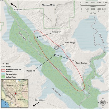
Pueblo Grande de Nevada is an eleventh-century Ancestral Puebloan village, located about 100 km (60 miles) east of Las Vegas, Nevada, and several airline miles south of the modern town of Overton in the Moapa Valley (Figure 1). Archaeologically, it is composed of a 5 km long concentration of prehistoric habitations, artifact scatters, bedrock mortars, and one cave along the east side of the Muddy River floodplain. Southwestern archaeologists typically refer to Ancestral Puebloan homelands west of Kanab Creek as the Virgin Anasazi branch—a designation taxonomically equivalent to the Kayenta, Cibola, and Mesa Verde Anasazi branches. Throughout the entire Virgin Anasazi area, and through all prehistoric time periods, Pueblo Grande de Nevada represents the largest known aggregation of contemporaneous habitations and perhaps one of only two communities with multiple, face-to-face, residential groups (Lyneis Reference Lyneis1995). This is important because the term “face-to-face community” refers to the number of people who interact on a daily basis with each other (Murdock Reference Murdock1949; Peterson and Drennan Reference Peterson and Drennan2005; Smith Reference Smith2010). For the most part, the largest habitations found in the Virgin Anasazi area do not exceed 15 rooms and were inhabited by no more than a nuclear or extended family (Harry and Watson Reference Harry and Watson2010; Lyneis Reference Lyneis1995). Population estimates for the Pueblo Grande de Nevada community range from 150 to 225, which means that it contained a number of discrete—if not unrelated—kin groups that required sociopolitical coordination beyond that of the nuclear or extended family (Haynes Reference Haynes2010; Lyneis Reference Lyneis1992).
Pueblo Grande de Nevada and vicinity. (Image courtesy of Dylan Person.)

Since its discovery in the 1920s, Pueblo Grande has seen several intense but sporadic periods of archaeological research, including the recent NPS-UNLV investigations. Initial fieldwork was conducted under the direction of Mark Raymond Harrington from the Southwest Museum of Man between 1924 and 1941. Harrington worked not only at Pueblo Grande but throughout the Moapa Valley, excavating 120 habitations with over 600 individual rooms, 289 burials, 12 rock shelters, and two caves (Harrington Reference Harrington1927; Shutler Reference Shutler1961). Harrington's work proved that Ancestral Puebloan peoples had a much wider western distribution than anyone had previously believed, and that the size and scale of occupation in the Moapa Valley is comparable to other Anasazi branches farther east.
Margaret Lyneis's fieldwork was conducted primarily in 1979 and then again in 1987 (Reference Lyneis1980, Reference Lyneis1992). She obtained controlled surface collections at, and conducted condition assessments of, all habitation loci at Main Ridge. Her work proved that a number of related ceramic types were found in similar proportions across all households on Main Ridge. Based on these data, Lyneis inferred that most of the households were contemporaneous during the middle Pueblo II period, from AD 1050 to 1100.
Taken as a whole, this means that Main Ridge represents only one part of a dispersed or nonaggregated face-to-face village. Lyneis's most recent population estimate is that Main Ridge consisted of at least 100 people, and this number is based on the total number of habitation rooms, which she minimally estimated to be 32 (Lyneis Reference Lyneis1992:75). Considering the other habitation loci excavated by Harrington across the entire 5 km complex, it is likely that the overall size of the community was considerably larger—or 150 to 225 people (Haynes Reference Haynes2010:Table 1, 321). Consequently, Pueblo Grande village—at the far western edge of the Puebloan world and in the most arid region of the continental United States—is the first village-size aggregation west of the Chacoan regional system. Moreover, the village is contemporaneous with the Chacoan polity, must have known of it, and may have openly traded with it (Lyneis Reference Lyneis1992; Rafferty Reference Rafferty1990).
Pueblo Grande's material culture would be recognizable to any Southwestern specialist or aficionado. Pit houses, houses-in-pits, and surface rooms can be found singly or in any combination throughout the complex. The largest pueblos are on the valley floor—Houses 46 and 47—and consisted of multiple arcs of surface rooms that partially enclosed plazas (Shutler Reference Shutler1961:Plates 25 and 30). Conversely, pueblos built on the narrow ridges that overlook the valley are, as Lyneis (Reference Lyneis1992:18) states, “placed on available flat expanses along the crests and ridges that were fitted to the available space.” Where space is available, these houses resemble C-shaped pueblos. A salient point is that adequate rock, particularly thick sandstone, is readily available in the immediate area. Not only was this sandstone used in housing construction, but it provided the raw material for ground stone artifacts and the medium for bedrock mortars. In addition, flaked stone artifacts were made from locally available quartzite cobbles found on old Pleistocene-age surfaces at the base of Mormon Mesa (Gardner Reference Gardner1968).
Site Types and Settlement Patterns
The archaeological sites present on the landscape today fall into a number of generalized categories: (1) habitations or pueblos; (2) mixed artifact scatters; (3) flaked stone knapping stations; (4) bedrock mortar concentrations; and (5) possible trails; plus, isolated artifacts. In addition to these site types, a number of caves and rock shelters were excavated by Harrington in the immediate vicinity (Shutler Reference Shutler1961).
These site types are generally segregated by topographic positions on the landscape: from the valley floor at elevations that range from 351 to 361 m (1,153 to 1,185 feet), to the low knolls and ridge tops that edge the valley, to the tableland that forms the base of Mormon Mesa at around 411 m (1,350 feet). Based on USGS topographic maps, of which some predate Lake Mead, the channel of the Muddy River would have been below 350 m (1,148 feet) in elevation, so all of the sites currently documented as part of the village complex are positioned either on the floodplain of the Muddy River or on the high ground surrounding it.
Mixed artifact scatters are most common on the valley floor, although Harrington excavated several habitations in this setting, notably Houses 46 and 47. Bedrock mortar concentrations are positioned on tabular sandstone outcrops at the base of the escarpment edging the valley. Before Lake Mead, caves and rock shelters were located on the steeply sloped escarpment that also edges the valley, protected by a thick ceiling of consolidated sandstone. Habitations are present today on benches, the tops of knolls, and the crests of long finger-like ridges that overlook the valley. Scattered knapping debris and isolated knapping stations are primarily located on the dissected tableland below Mormon Mesa. This high, flat ground is covered with desert pavement that contains large quartzite tool-stone cobbles. What appears to be a prehistoric trail is also present on this high ground, crossing the desert pavement northward from the village toward Mormon Mesa. Germane here is that only the high ground under Mormon Mesa remains unaffected by Lake Mead. Not surprisingly, the archaeological sites associated with each topographic zone experienced very different impacts.
Physiographic Setting
A full appreciation of how Lake Mead affected Pueblo Grande cannot be obtained without some understanding of the immediate landscape (see Figure 1). This is because local geology and topography play an important role in the kinds of lake-related processes that took place, along with their varying levels of intensity. The Moapa Valley is broad and U-shaped, with the Muddy River flowing down the middle of it. Floodplains rise gently on either side of the river before meeting an abrupt 6–12 m (20–40 feet) high escarpment. This escarpment is the edge of a dissected mesa-like landform that is much older than the modern valley floor (Gardner Reference Gardner1968). The more recent natural processes that formed the Moapa Valley, along with modern Lake Mead, has eroded this older landform into a remnant pediment around Mormon Mesa, with long finger-like ridges that edge the current valley and where many of the habitations are positioned.
The area's near-surface bedrock is composed of what geologists call the Muddy Creek Formation (Longwell Reference Longwell1928:Plate 1; Schmidt et al. Reference Schmidt, Page and Workman1996). The strata associated with this formation can be as thick as 600 m (2,000 feet) in places and consist primarily of loose sands and silts, interlayered with beds of tabular sandstone (Gardner Reference Gardner1968). A good description of this strata comes from the field notes of geologist David Weide, who visited Pueblo Grande in 1979:
Site is constructed on a thin sandstone unit within the Muddy Creek Formation. Stratigraphic column here is . . . 20 feet massive very fine sand and silt, poor cementation, 0.75’ well cemented sandstone, medium-to-fine grained, with cross-bedding [This bed supports the lowest exposed structures and bed-rock mortars.], 6 feet, poorly consolidated silt (all silt units are easily eroded!), 1 foot moderately well-cemented sandstone bed, 16 to 20 feet gypsiferous silt, 0.75’ sandstone bed [this bed supports Complex#26 on Harrington's map], 5’ silt, 6’ silt, 1.5’ sandstone bed [supports structures of Complex 27]. Stopped measuring section in this unit [Lyneis Reference Lyneis1979:12].Footnote 1
What is clear from Weide's description is that the stratigraphy on the east side of the Muddy River is composed of thick layers of poorly cemented coarse to very fine sand and silt. In between these poorly cemented layers are 20–30 cm (0.75–1.0 feet) thick layers of tabular sandstone. It is the cemented sandstone layers that support the Puebloan houses and provide raw material for both architecture and ground stone artifacts. Results from the current investigations indicate that the composition of these strata, coupled with their superposition, strongly influences lake-related processes.
The surface on which the Puebloan ruins reside has been defined by Gardner (Reference Gardner1968:61) as the “Lost City Surface.” It is one of three surface remnants that have weakly cemented caps and that lie at 12–30 m (40–100 feet) above the modern valley floor. Subrounded quartzitic toolstone present in the desert pavement were likely secondarily deposited by alluvial processes across these ancient surfaces.
Current vegetation on the ridge tops and higher ground along the lower Muddy River is probably little different from what Harrington encountered in the 1920s and 1930s. It is composed of a creosote-bursage (Larrea tridentata, Ambrosia dumosa) plant community, intermixed with various other sparse woody shrubs, grasses, and cacti. Conversely, the emergent valley floor is now overwhelmed with invasive salt cedar (Tamarisk spp.), a vegetation community much different from what was there prior to Lake Mead.
THE EFFECTS OF INUNDATION AND EMERGENCE: RESULTS FROM SURFACE INVENTORY
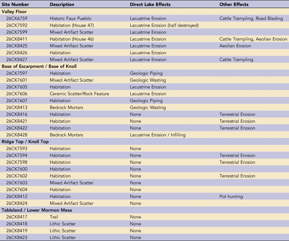
The effects of Lake Mead are visible up and down the lower Muddy River, and the natural processes associated with the lake have produced a wide variety of impacts to the archaeological sites that make up Pueblo Grande. The purpose here is to describe these effects and evaluate how they have altered, and in some circumstances helped to preserve, these archaeological sites. The information is based on findings obtained during an archaeological survey conducted jointly by NPS-UNLV field crews from the fall of 2006 to the spring of 2008 (Haynes Reference Haynes2008; Table 1). What follows is not meant to be a systematic and exhaustive narrative. Rather, the intent is to present the most important and interpretable effects by discussing a number of specific sites that best illustrate them.
Site Descriptions and Lake Effects Summary.

Sites Inundated by Lake Mead
Of the 29 prehistoric sites identified over the course of the inventory, 13 (43.3%) exhibit direct lake-related effects as a result of inundation and emergence. Six of these are habitations, and lacustrine alterations are relatively easy to identify. At other loci—those that contain a mix of portable artifacts—it is often difficult to ascertain the exact processes that affect their integrity, but some evidence secondary artifact erosion, or winnowing, as a result of lacustrine processes. At bedrock mortar concentrations, lake processes have undermined the Muddy Creek Formation, causing the sandstone shelf to collapse and filling the holes with sediment. Most artifacts that may have once been associated with these features have likely been winnowed by the lake or removed by visitors.
House 47 (26CK7592) is one of the largest pueblos excavated by Harrington at Pueblo Grande. A plan map in Shutler (Reference Shutler1961:Plate 30) shows that more than 60 rooms were excavated and that these rooms formed at least two C-shaped pueblos. Its position on the valley floor proves that it was completely inundated by Lake Mead. Today, all that is visible are portions of two arc-shaped room blocks, several isolated rock-lined rooms or features, and a handful of surface artifacts. Many of the rooms Harrington excavated, along with what should be a dense artifact scatter, have either been eroded by lake recession, or sedimentation has completely covered them.
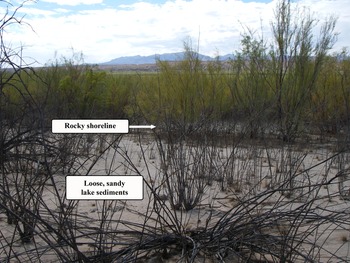
The western portion of House 47 resides on a gentle slope that declines toward the center of the valley (Figure 2). Field observations indicate that this declination served to intensify wave action and create sand and gravel shoreline features as the lake receded from around the pueblo. At the same time, it appears that these processes served to erode surface rooms and remove much of the artifact assemblage. This inference is supported by a 2.0 × 0.5 m test unit excavated into the shoreline that found no subsurface features or artifacts. Conversely, abundant surface rooms are visible on the east side of the site where the valley floor is flat. Although few artifacts remain present on the surface, test excavations revealed that an abundant assemblage is still contained within the substrate, underneath an upper silt and clay-rich lakebed sediment layer (see below).
House 47 (26CK7592), originally on the floodplain of the Muddy River, has a slightly declining topography on its west side, and rocky shoreline deposits formed as Lake Mead receded, whereas it has a flat topography on its east side, causing lake sediments to remain intact. (Photo by Gregory Haynes, Public Lands Institute, University of Nevada, Las Vegas [UNLV].)

House 46 (26CK8411) is another large site with multiple room blocks positioned on the valley floor. This site, too, was excavated by Harrington, but it presents a much different example of how lake-related processes affected habitation sites. This large pueblo resides on a generally flat, gently undulating surface that likely served to pond water as the lake receded, greatly diminishing high-energy wave action. Moreover, a thick 5 cm stratum of lakebed sediment covers the site. Importantly, the small-size lakebed particles (i.e., silts, clays) create cohesion between the sediment and the artifacts holding them into the substrate. Based on field observations, we hypothesize that the generally flat nature of the terrain, coupled with the soft cohesive lacustrine substrate, served to preserve much of the site, whereas the partially tilted topography at House 47 served to intensify wave action, destroying much of the pueblo and sweeping away that portion of the artifact assemblage.
House 21 and 21ˈ (26CK7605) are excellent examples of how lake recession affected architectural features differently—in one case, destroying, and in the other case, preserving—based on slight topographic and landform variations. House 21 was a large 10−15 room pueblo positioned at the base of an isolated knob on the valley floor, about 100 m away from Main Ridge. A modern shoreline is evident at the knob's base, and the wave action that formed it may well have obliterated the pueblo, leaving only a scatter of rubble. House 21ˈ, on the other hand, remains intact even though it is not more than 20 m away. The crucial feature in preserving House 21ˈ is that, hypothetically, it is slightly lower in elevation and positioned on a broad flat bench—factors that served to dissipate energy in the waves.
Most of the resources inundated by Lake Mead evidence some form of artifact displacement or assemblage alteration. Some assemblages appear to represent two related types of alterations: differential artifact removal, or winnowing, and secondary deposition. Two sites (26CK7601, 26CK7606) are dominated by relatively large or heavy artifacts, such as ground stone and cores for the former, and a rock concentration with over 40 rocks for the latter. Much of the small lightweight artifacts has seemingly been removed or winnowed from the assemblage. Both of these sites are positioned near the edge of the valley in what would have been a shallow pool area. The inference is that lake currents, near-shore wave action, or rather rapid lake recession suspended the lighter artifacts and removed them from the rest of the site.
Conversely, if smaller artifacts get differentially removed from a site, then those artifacts eventually get deposited elsewhere. Two other artifact scatters (26CK7599, 26CK8427) are dominated by small and lightweight artifacts—notably, debitage and pot sherds—as if the larger, heavier artifacts had been removed. Importantly, both are positioned well out onto the floor of the former lakebed. It may be that the assemblages at these two sites had been secondarily removed from a parent assemblage, then redeposited as a unit elsewhere.
Geologic Wasting and Piping
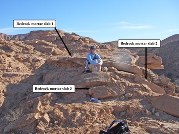
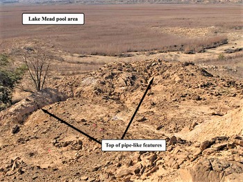
One of the most striking features of the landscape along the lower Muddy River is the amount of geologic collapse or “wasting” that has occurred because of the lake (Allaby Reference Allaby and Allaby2013; Highland and Bobrowsky Reference Highland and Bobrowsky2008). This is because the local geology and topography both serve to intensify various erosional processes. Large-scale geologic wasting affects the Muddy Creek Formation when water current or wave action undermines the thick, loose, silty-sandy strata, as described above by Weide at Main Ridge. Once these strata are removed, there is no support for the overlying tabular sandstone beds, causing them to collapse or topple along with everything that is on or above them. All along the edge of the valley, huge blocks of tabular sandstone skirt the ridges, bluffs, and low knobs (Figure 3). “Piping,” another process that Weide observed at Main Ridge, also affects the Muddy Creek Formation when lake waters tunnel into the loose silty-sandy strata (Faulkner Reference Faulkner, Nadal-Romero, Murillo and Kuhn2018; Lipar et al. Reference Lipar, Szymczak, White and Webb2021). Eventually, a portion of the surface above the tunnel will collapse and form a stovepipe-like depression. Once the pipe is formed, headward erosion becomes rapid and catastrophic and continues until the process reaches equilibrium or there is no longer any sediment left to erode (Figure 4). Wasting and piping can quickly destroy archaeological sites, and evidence for both of these processes is visible across the Pueblo Grande complex.
Site 26CK8413, located at the end of an elongated bluff, exhibits the effects of mass wasting. Inundation weakened the lower unconsolidated silt and sand layers, causing the upper tabular sandstone layers to collapse. (Photo by Gregory Haynes, Public Lands Institute, UNLV.)

Site 26CK7607, located on top of a knoll, was once mostly surrounded by Lake Mead. Inundation undermined the side of the knoll causing stovepipe-like cavities to form and creating depressions in the top of the knoll where the site resides. (Photo by Gregory Haynes, Public Lands Institute, UNLV.)

Previous research and current inventory findings show that habitation loci are commonly found on the low ridges, bluffs, and isolated knobs along the edge of the valley floor. The piles of sandstone located around the base of these ridges prove that a large amount of tableland that once composed the edge of the valley has been removed or collapsed onto the valley floor. It stands to reason that some archaeological sites once positioned on the top of this land have now been destroyed. This inference is strongly supported by the number of houses on Main Ridge that have not been relocated following Harrington's investigations (see below). In addition, the position of one mixed artifact scatter (26CK7601) and a bedrock mortar site (26CK8413), both located on benches below a heavily eroded ridge, are likely the result of geologic wasting (Figure 3).
Piping is particularly evident at two habitations recorded during the inventory (26CK7597, 26CK7607), of which the latter is demonstrative. This site, 26CK7607, is positioned on a low knoll overlooking the valley. Individual rooms are placed in circular fashion around an open plaza. The substrate on which these features reside is composed of a thick bed of loose silt and sand. Deep, pipe-like formations have developed along the edge of the bench and in the middle of the plaza (Figure 4). If water levels ever rise to their previous elevation, piping will resume with catastrophic effects to this particular habitation.
Indirect Lake Effects
Several other impacts, some natural and some human made, have been documented at Pueblo Grande. All of these occur not as a result of the water, but because of its decline. The most obvious and pervasive is the tamarisk forest on the lakebed floor. The loose silt and sand near the receding water creates an ideal habitat for these salt-resistant tree species, and they grow prolifically. Although tamarisk grows on most of the sites recorded on the former lakebed, it is not clear to what extent it has altered archaeological resources.
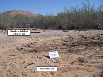
Aeolian or wind-blown sand is another natural process currently affecting sites exposed as a result of emergence. At two sites (House 46/26CK8411, 26CK8425), large portions of the 3–5 cm thick lacustrine-derived sediment cap has been removed by high winds, and the underlying sand deposit has been scoured to form undulating “blowouts” (Figure 5). Not only are inorganic artifacts being exposed and moved around secondarily by wind, but aeolian erosion has exposed fire-related features and bone.
Site 26CK8425 was inundated by Lake Mead, but the accumulation of lakebed sediment served to protect the underlying archaeological site. Recent aeolian processes have removed a portion of this cap, exposing the underlying cultural deposit (Photo by Gregory Haynes, Public Lands Institute, UNLV.)

Whereas the lake served to isolate Pueblo Grande from human visitation, the area's current emergence allows for easy foot traffic, dispersed recreation, and other activities. Illegal excavation and casual artifact collecting is now easy to undertake because of the lake's recession. Importantly, evidence for these activities remain limited. It was not uncommon during fieldwork to observed people hiking in the immediate area, and it is more than likely that some level of casual artifact collecting is ongoing at Pueblo Grande. Despite this, only one habitation (26CK8412) was found to have been illegally pot hunted during pedestrian inventory.
Only one site on the lakebed has been substantially damaged by recent human activities. This site is a European-American faux pueblo (26CK6759), constructed in 1925 for a Native American–themed pageant (Harry Reference Harry, Slaughter, Daron, Jensen and Sprowl2009). It was damaged when a bulldozer was used to grade a two-track road through it around the base of the escarpment. The bulldozer cut a swathe through the pueblo, destroying about 10% of the site.
Finally, cattle effects are readily observed in the form of dung, hoof tracks, and incised trails. And it was not uncommon during fieldwork to observe a herd in the area, oftentimes grazing on a habitation. Cattle would not be able to access this area without the decline of Lake Mead and the emergence of the valley floor. Not limited to unevaluated sites recorded during inventory, these impacts are also present at Main Ridge within the National Register District (Maxon and Kirkberg Reference Maxon and Kirkberg1982). Like tamarisk, it is difficult to quantify the damage caused by these animals on archaeological resources. Suffice it to say that a herd residing for a period of time on a habitation can destroy its architectural features, churn up in situ deposits, and break up stone, bone, and ceramic artifacts. Cattle dung and urine could also potentially affect culturally derived residue on flaked stone tools, ground stone, and ceramics.
THE EFFECTS OF INUNDATION AND EMERGENCE: IMPLICATIONS FROM LIMITED TEST EXCAVATIONS
In addition to the inventory, test excavations were conducted at three sites on the valley floor that had been inundated by Lake Mead: House 46 (26CK8411), House 47 (26CK7592), and the European-American faux pueblo (26CK6759). A number of stratigraphic findings are particularly relevant here and allow for greater interpretive detail regarding lake-related processes at archaeological sites.
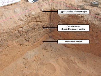
Although slight topographic differences exist between House 46 and House 47, the same basic stratigraphy is present at each one. The profile in four of these test units consists of two stratigraphic layers. The first and uppermost level, Stratum 1, is composed of a fine-grain, grayish, silt-and-clay sediment no thicker than 5 cm. The second and lower level, Stratum 2, is a massive homogeneous layer of light tan to yellow sand devoid of any obvious interbedding. As previously discussed, the uppermost layer is lakebed sediment, whereas the lower layer is wind-blown sand. An important observation is that the lower sand layer does not contain any flood deposits, so it appears that the two largest habitations at the village were positioned above or at the upper limits of the Muddy River floodplain. This is supported by differences in elevation between the historically documented channel of the Muddy River at 350 m (1,148 feet), and House 46 at 354 m (1,162 feet), the lower of the two prehistoric sites. Over time, lake-related processes flattened out most undulations on the valley floor and deposited a thin layer of fine-grain silt and clay across the entire area. That the lake gently receded is well illustrated by the fact that so much of the thin lakebed sediment remains intact. Aeolian deflation is now stripping away portions of the clay-rich upper stratum and exposing the lower, loose, sandy stratum.
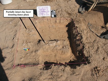
Importantly, the topmost sedimentary layer serves to cap the archaeological deposits and protects the sites from adverse inundation processes and lake recession. For instance, recent inventory-level documentation at House 47 recorded only a handful of artifacts across the surface. However, test excavations at both sites revealed a richer artifact assemblage contained within and immediately beneath this thin lacustrine layer. Two test units were excavated at both House 46 and House 47; of the 253 flakes recovered, 226 (89%) came from Stratum 1 (Haynes Reference Haynes2009). And it is not only artifacts that the lacustrine deposit served to protect. Another test unit placed in the central plaza at House 47 revealed a rich midden deposit. Likewise, a test unit excavated in the plaza of the European-American faux pueblo uncovered an intact clay floor (Figures 6 and 7).
Test excavations in the eastern portion of House 47 (26CK7592) reveal a midden deposit protected by sand and lakebed sediment. (Photo by Gregory Haynes, Public Lands Institute, UNLV.)

Test excavations in the plaza of a European-American faux pueblo (26CK6759) reveal a clay-lined dance plaza. (Photo by Gregory Haynes, Public Lands Institute, UNLV.)

THE EFFECTS OF INUNDATION AND EMERGENCE ON ARCHITECTURAL FEATURES AT MAIN RIDGE
Main Ridge (26CK2148) refers to a concentration of Ancestral Puebloan houses spread up and down several narrow ridges that overlook the broad floor of the Muddy River. Originally, Harrington identified 45 “houses” and designated each one with a number (1−45). However, two of these houses consist of two discrete room blocks, so Main Ridge is composed of 47 individual architectural components. Taken as a whole, these houses represent the single greatest concentration of architectural features at the village, and over the years, it has received the greatest focus of research.
Whereas Harrington did not make detailed plan maps for every house, he did make a topographic map that includes the location and general floor plan for all 47 room blocks (Lyneis Reference Lyneis1992:Figures 3, 5, 6; Shutler Reference Shutler1961:Plate 25). Given the rugged topography and a thousand years of abandonment, it is not surprising that Harrington found many of these features already damaged by erosion (Harry and Osborne Reference Harry, Osborne and Harry2008:7; Lyneis Reference Lyneis1992:10). Obviously, lake-based erosion, like geologic wasting and piping, could not have occurred before Lake Mead, but alluvial and colluvial erosion, along with any headward drainage cutting, could have severely damaged some of these features.
Much later, during the 1980s, Lyneis used Harrington's map as a basis for her own fieldwork. Her investigations commenced in response to modern Lake Mead highstands that threatened to destroy Main Ridge. Using Harrington's map, Lyneis (Reference Lyneis1992:10) discovered that “the topography and placement of houses [on his map] appear to be accurate, but the details of the tiny house plans should be regarded as schematic.” Investigations at that time relocated 33 houses at Main Ridge, of which 29 were “partially intact,” four more were “submerged,” and 12 others “destroyed” (Harry and Osborne Reference Harry, Osborne and Harry2008:9). Lyneis prepared detailed plan maps for at least 24 of the 29 houses that remained above water (Reference Lyneis1992:Figures 7a−7t). So, by the end of Lyneis's fieldwork in 1987, 29 of the 47 individual architectural components—or 62% of the architectural features documented by Harrington before Lake Mead—were still above water and to some degree intact (Table 2).
Condition of Architectural Components at Main Ridge over Time.

Note: Adapted from Harry and Osborne Reference Harry, Osborne and Harry2008:Table 2.1.
A systematic condition assessment of Main Ridge was accomplished in the fall of 2006 as part of a UNLV archaeological field school (Harry and Osborne Reference Harry, Osborne and Harry2008). Like Lyneis, Harrington's original map proved indispensable in order to move across the ridges and identify previously documented features. In addition, an up-to-date GPS map was made in conjunction with the condition assessments, and it confirms the overall accuracy of Harrington's map of Main Ridge. As a result of this fieldwork, 46 of the original 47 architectural components previously documented from Main Ridge could be assessed for their condition. Of these 46, only 20 (42.5%) of the original 47 are still intact to some degree (Harry and Osborne Reference Harry, Osborne and Harry2008:9; Table 2). Furthermore, this means that 15 of the 33 “houses” identified by Lyneis, or 45%, have been destroyed by Lake Mead or by the formation of drainages over a 19-year period. Maps produced by Harry and Osborne (Reference Harry2008:Figures 2.1−2.3) clearly show that the houses no longer present in the 1980s, and then later in 2006, parallel the rise in lake water levels. It is reasonable to conclude that all 27 architectural components destroyed since the time of Harrington's excavations—that is, 57% of the original 47 components—occurred as a direct result of Lake Mead, either through wholesale inundation, high-energy wave action, geologic wasting, or piping.
Because the lake eroded the steep escarpment edging the valley, once the water receded, terrestrial erosion was enhanced. Most, if not all, remaining architectural components found during the 2006 condition assessment exhibit some form of terrestrial erosion—including alluvial and colluvial erosion—and headward drainage cutting (Harry and Osborne Reference Harry, Osborne and Harry2008). For instance, it appears that two of the four rooms recorded at House 29 in 1987 are now all but destroyed by headward drainage development. Indeed, Lyneis's documentation shows that this landform was stable from 1925 to 1987, proving that the loss of both rooms happened in the years following the lake highstand (Harry and Osborne Reference Harry, Osborne and Harry2008:20). Of the four rooms documented at House 45 in the 1980s, more recent alluvial and/or colluvial erosion has claimed three. Given the specific physiographic characteristics of Main Ridge, terrestrial erosion processes, enhanced at times by torrential rains, will continue to degrade these architectural features.
CONCLUSIONS
The effects of Lake Mead on Pueblo Grande de Nevada have been catastrophic but not entirely so. Where high-energy lake processes such as wave action and shoreline development get concentrated, archaeological sites or loci are damaged or destroyed. House 47 is an excellent example of this: field observations and test excavations indicate that at least half of the large pueblo has been eroded as a result of these processes. Also, given that water at the edge of the lake's impoundment zone can undermine geologic formations, such as the mass wasting and piping that occurred to the Muddy Creek Formation, archaeological sites that reside on top of them are at risk of damage or destruction. These particular effects are evident throughout much of the 5 km long village complex. High-energy lake processes, mass wasting, and piping have all likely contributed to the destruction of architectural features on Main Ridge.
At some sites or loci, the exact nature and extent of damage is difficult to assess. There is circumstantial evidence that wave action or lake recession modified artifact assemblages by removing or winnowing lighter-weight artifacts and then secondarily depositing these artifacts elsewhere on the lakebed. Because pre-inundation baseline data do not exist for many of the sites across the complex, how lacustrine processes may have modified these assemblages cannot be fully understood. The extent that tamarisk growth has altered the archaeological record or, likewise, what the long-term effects of cattle trampling to surface assemblages and subsurface deposits may be, has never been empirically assessed. Actualistic and laboratory-based studies could be designed to model these kinds of processes and create a baseline for understanding these effects in real-world situations.
Not all sites or loci inundated by Lake Mead, however, are destroyed. Sites that remain intact are generally positioned on flat ground where the effects of high-energy wave processes or lake recession could not be concentrated. In addition, many of the sites on the valley floor are covered by a protective anaerobic layer of silt and clay. Topographic position and sedimentation are hypothesized to have preserved these resources, such as House 46 and a portion of House 47, among others. These findings are supported both by inventory-level documentation and by test excavations at sites on the valley floor. Today, wind-related processes and cattle are breaking up the protective sediment cap, churning artifacts, and exposing sensitive deposits.
Despite the effects of Lake Mead, a rich and abundant archaeological record is still intact at Pueblo Grande de Nevada (Harry Reference Harry2008; Harry and Watson Reference Harry and Watson2010; Haynes Reference Haynes2008, Reference Haynes2009). Twenty architectural features remain at Main Ridge, whereas 29 other prehistoric sites or loci, including 16 Puebloan habitations, are documented from across the rest of the village complex. Ceramic, flaked stone, and ground stone artifacts dominate these assemblages. Moreover, some still contain fire-related features, data-rich floral and faunal remains, and intact midden deposits. An important result of the most recent investigations at Pueblo Grande de Nevada by the NPS and UNLV is that many archaeological resources remain intact, both in terms of habitations and others that are more specialized.
In recent years, prolonged drought has dramatically reduced the pool sizes of many reservoirs in the western United States, revealing a wide variety of cultural resources that have long been submerged. Land management agencies, such as the NPS, have recognized the importance of these emergent resources and have endeavored to document them, assess their condition, and preserve them (Perttula et al. Reference Perttula, Ireugas and Ellis1996, Reference Perttula, Hester and Ireugas1997). Relatedly, climate change threatens to inundate intertidal zones worldwide, and these areas will undoubtedly have cultural resources that undergo processes like those documented at Lake Mead. As these long-term trends continue, future work will need to document not only the ways archaeological sites and other cultural resources are affected by inundation and emergence, but also those preservation strategies and best practices that can mitigate their impacts and aid in preserving our national heritage.
Acknowledgments
All the field and laboratory work covered in this article was sponsored by Lake Mead National Recreation Area and conducted jointly through a Cooperative Ecosystem Studies Unit agreement between the National Park Service and the University of Nevada, Las Vegas (Great Basin Cooperative Ecosystem Studies Unit Agreement No. H8R07010001, Task Agreement Nos. J8R07050006 and J8R07060013). Correspondingly, the NPS provided all of the necessary permits required to conduct the cultural resource investigations on lands they administer. The late Steve Daron, then park archaeologist, and Rosie Pepito, LMNRA's cultural resource officer at the time, deserve special mention for supporting in so many ways all the related archaeological projects that took place at Pueblo Grande de Nevada. My thanks to Dr. Karen Harry at UNLV and Dr. Staffan Peterson, former chief of cultural resources at LMNRA, for reviewing this manuscript and offering helpful suggestions for its improvement. Karen also allowed the results of her condition assessment at Main Ridge to be included in this manuscript; an article about lake-related effects at Pueblo Grande would not be complete without it. I am grateful to three anonymous reviewers whose comments and suggestions very much improved the quality and content of the manuscript. My thanks also to Cheryl Collins and Dylan Person who assisted at the last minute with the figures, and to Manuel de Cespedes Molina for translating the abstract and keywords into Spanish. Finally, a number of people deserve special recognition for their help during fieldwork: Glendee Ane Osborne, Liz Roycraft, Erin Eichenberg, and Hal Rager.
Data Availability Statement
This study is based on fieldwork conducted at Lake Mead National Recreation Area by the University of Nevada, Las Vegas, between 2006 and 2008. All data are available through sources listed in the References Cited section.
Competing Interests
The author declares none.