Research combining lidar analysis, field inspection, and excavation at the ancient Maya site of Yaxnohcah in southern Mexico has revealed the multifunctional nature of small topographical depressions. Initially quarried for limestone, these features were then sealed and used as small water reservoirs. We classify these water-storage features as quarry-reservoirs.
Yaxnohcah is located in the Central Karstic Uplands of the Yucatán Peninsula, approximately 15 km southeast of Calakmul (Figure 1). Building on previous work by Šprajc (Reference Šprajc2008), the Proyecto Arqueológico Yaxnohcah was initiated in 2011 and has analyzed lidar data, conducted ground survey, and excavated numerous residential and water features across the expansive site area (see Reese-Taylor et al. [Reference Reese-Taylor, Hernández, C, Esquivel, Monteleone, Uriarte, Carr, Acuña, Fernandez-Diaz, Peuramaki-Brown and Dunning2016] for lidar details).
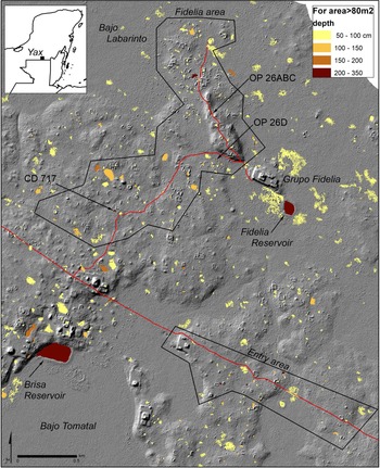
Lidar-derived hillshade image showing our two study areas. Coded by depth are the computer-identified closed depressions (CD) with surface area >80 m2 and depth >50 cm (n = 494)—the household reservoir candidates. For comparison, two central-precinct reservoirs are indicated by arrows. Note CD 717, our reference quarry. Inset: Yaxnohcah location. Map by authors. (Color online)

A six-month dry season necessitated the development of multiple levels of water storage by the ancient Maya. These storage features range from well-studied, large, central-precinct reservoirs to individual household water jars (Brewer Reference Brewer2018; Scarborough and Gallopin Reference Scarborough and Gallopin1991; Weiss-Krejci and Sabbas Reference Weiss-Krejci and Sabbas2002). In addition, depressions of varying sizes that originated as either natural karstic sinkholes or as anthropogenically quarried cavities often were sealed to retain water (Dunning et al. Reference Dunning, Griffin, Jones, Terry, Larsen, Carr, Lentz, Dunning and Scarborough2015; Horowitz et al. Reference Horowitz, Clarke and Seligson2021). These small water-storage features may have been individually or communally controlled “household tanks,” providing for the needs of individual homesteads or a group of residences (e.g., a plaza group). They were often located in residential areas removed from the urban core. We used lidar to map the location of candidate depressions and to guide us to those locations for field inspection and excavation. Expanding our previous study of small depressions (Brewer et al. Reference Brewer, Carr, Dunning, Walker, Hernández, Peuramaki-Brown and Reese-Taylor2017), we excavated two closed depressions in non-elite residential areas during our third field season at Yaxnohcah (Brewer and Carr Reference Brewer, Carr, López, Hernández and Reese-Taylor2019).
We automated the analysis process to facilitate our search of the 24 km2 lidar area for low spots where water could collect (closed depressions). This allowed us to focus on depressions that were difficult to identify by visual examination of lidar images and hard to locate through field inspection. The process used the ArcGIS hydrology “fill” tool, following Doctor and Young (Reference Doctor, Young, Land, Doctor and Stephenson2013). This automated process takes the difference between the initial and filled raster data and groups clusters of filled pixels into polygons (the closed depressions). Standard GIS tools were used to assign a maximum depth and surface area to each depression. We selected our candidate list of depressions based on (a somewhat arbitrary) lidar-derived depth greater than 1 m and a surface area greater than 80 m2.
Field Inspection of Candidate Closed Depressions
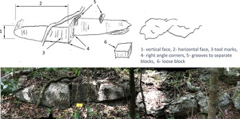
We inspected 66 closed depressions from two areas that are accessible by established project roads, selecting two for excavation based on their surface dimensions, proximity to residential structures, and general accessibility within the project area (Figure 1). Twenty-eight of the depressions from these two areas had lidar-derived depths greater than 1 m and a surface area greater than 80 m2. As we moved from place to place, we opportunistically assessed an additional 38 depressions (depths less than 1 m). We characterized the closed depressions as displaying evidence of quarrying (n = 48; Figure 2), displaying no evidence of quarrying (n = 8), or “other” (n = 10). The “other” category encompasses five depressions with ambiguous evidence of quarrying; three formed by post-abandonment rockfall plaza groups; and two whose enclosing berm was not visible, leading to them being mischaracterized in the field as not being “closed.” We further separated the closed depressions into three groups based on topographic position: those located in lowland bajos (solution pockets with a characteristic flat and level floor); those in upland area bajos, called pocket bajos; and those in upland areas outside of pocket bajos, which we call “upland non-bajo” (Table 1). Significantly, all 45 upland non-bajo depressions showed evidence of quarrying.
Elements used to identify a limestone quarry. This is one wall of CD 717 (depth = 2.0 m, surface area = 227 m2). Photo by authors. (Color online)

Number and Size of Closed Depressions (CD).

Note: All upland non-bajo CDs displayed evidence of quarrying, are small, and are close to structures.
A review of the dimensions of the field-inspected upland non-bajo closed depressions suggests the parameters of what the site's residents considered to be a “right-sized” household reservoir. We found 20 depressions with a lidar-derived surface area less than 100 m2 (minimum size: 18 m2), 18 from 100 to 200 m2, and 7 from 200 to the maximum of 290 m2. The smallest closed depressions may represent quarries that were in use at the time of site abandonment. Although the majority of these depressions are less than 200 m2 in surface area, we hypothesize that the desired finished feature may be more in line with the maximum surface area—perhaps 200–300 m2—based on the residents’ desire for a reservoir large enough to provide for household needs while not taking up excessive living space. The distance between quarry-reservoirs and the nearest residential structures ranges from 3 to 87 m (median: 31 m), suggesting a strong spatial linkage between quarry and residence. The “signature” of a quarry-reservoir—a household water tank—is a small, roundish feature displaying quarry marks and located in the uplands near a residential structure.
Excavations of Candidate Closed Depressions
Operation 26ABC
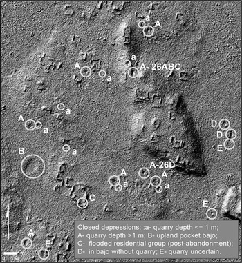
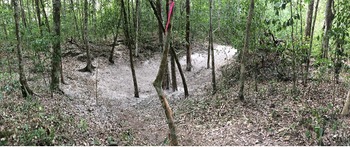
This closed depression is located roughly 700 m northwest of Grupo Fidelia (Figure 3). The exposed rock face around the depression (Figure 4) exhibits cut marks that meet our definition of a quarry, including grooves in the rock that would have generated quarry rubble.
Hillshade image of part of our study area with closed depressions identified by the computer model, field inspected, and excavated (A-26ABC and A-26D). This small residential area (0.9 km2) contains the 16 CD-quarry, which we suggest, based on its similarity to the two excavated depressions, is likely a reservoir under construction.

A typical closed depression of household-reservoir size (Operation 26ABC, backfilled post-excavation). Photo by authors. (Color online)

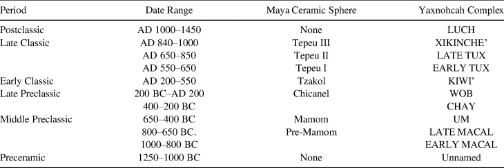
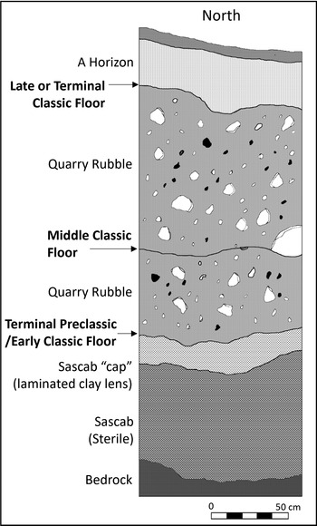
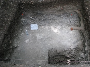
Based on dating of the recovered pottery sherds—n = 4,602; 49% identifiable (Table 2; Walker Reference Walker, Hernández, Peuramaki-Brown and Reese-Taylor2016)—the quarry-reservoir sequence started with a Preclassic period quarry, which was then leveled and sealed with a clay layer topped with a tamped sascab surface to create a watertight seal. Above this sealed Terminal Preclassic (200 BC–AD 200) to Early Classic (AD 200–550) period floor is a layer of quarry rubble consisting of extremely fine sandy clay, gravel, and cobbles located beneath the extremely degraded, virtually unrecognizable remains of a second, thinner-sealed Middle Classic (AD 550–650) surface (Figures 5 and 6). This floor is visible in the profile as a recognizable soil boundary separating the darker organic humus and sediment layer from the top of the lighter-gray sandy clay and gravel-cobble mixture. We also identified a third, uppermost surface corresponding to the Late or Terminal Classic (AD 650–1000). This floor was located beneath a layer of in-washed colluvium, which was separated from the underlying Middle Classic surface by another layer of quarry rubble. Within each rubble layer, we encountered numerous fragments of degraded plaster and stucco material that would have sealed these surfaces. A lack of water damage (no rounded, eroded edges) in the ceramic material suggests well-sealed plaster surfaces with little water exposure. Sherds represented just 0.5% by volume of the excavated material, negating the depression's use as a midden.
Yaxnohcah Ceramic Chronology.

Source: Based on Walker (Reference Walker, Hernández, Peuramaki-Brown and Reese-Taylor2016).
Operation 26A north profile showing three exposed floors.

Exposed Middle Classic period floor from Operation 26A. Photo by authors. (Color online)

The dates, the presence of three distinct floors, and the nature of the quarry rubble all support the conclusion that the quarry-reservoir experienced an extensive period of use during which the initial limestone extraction occurred; this was followed by three episodes of quarrying that left rubble that was then sealed with a floor. These dates are supported by 14C dates from Operation 26A, which range from the Late Preclassic (1990 ± 30 BP [ICA-0919; wood charcoal; no isotopic fractionation correction]) through Late Classic periods (580 ± 30 BP [ICA-0916; wood charcoal; no isotopic fractionation correction]).
Operation 26D
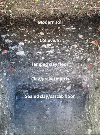
This closed depression likely also functioned as a water-storage feature. Its shape, depth, surface area, and partially exposed limestone quarry-like straight edges conform to our working profile of a quarry-reservoir (Table 3). We encountered a compacted, dark-gray clay layer that began approximately 50 cm below the ground surface. This layer may represent the heavily degraded remains of a thick, tamped clay sealant (Figure 7). Beneath this layer, we excavated through a less compact clay-and-gravel matrix that lay above what appeared to be a sealed clay-and-sascab lining overlying the base of the depression. Larger cobbles found at this depth likely would have served to level the uneven bedrock base of the depression before it was packed with this dense clay-mixed seal.
Operation 26D west profile showing two floors of varying construction. Photo by authors. (Color online)

Lidar-Derived Attributes of the Two Excavated Closed Depressions.

This operation recovered little cultural material, likely because this depression was more distant from structures in the area. Of the 88 ceramic sherds collected, only 26 were able to be typed and dated. These were associated with the Late Classic phase of occupation (AD 550–850) and were all recovered from the bottom two lots (Operations 26D-5 and 26D-6) of the unit. Based on this limited evidence and the nature of the sealing method used in the depression, this feature may represent a comparatively low-tech Late Classic reservoir. The tamped clay floor corresponds to other Preclassic and Classic period aguadas excavated elsewhere in the Maya Lowlands (Akpinar Ferrand et al. Reference Akpinar Ferrand, Dunning, Lentz and Jones2012; Scarborough et al. Reference Scarborough, Dunning, Tankersley, Carr, Weaver, Grazioso and Lane2012) and to sealed surfaces encountered in small, closed depressions investigated over prior seasons at Yaxnohcah (Brewer Reference Brewer2018; Brewer and Carr Reference Brewer, Carr, López, Hernández and Reese-Taylor2019).
Discussion
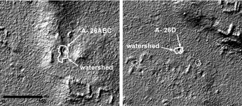
The creation and use of small depressions for water management have been demonstrated to be a temporally and spatially widespread practice beginning in the Preclassic period (Brewer Reference Brewer2018; Chase Reference Chase2016; Weiss-Krejci and Sabbas Reference Weiss-Krejci and Sabbas2002). Similarly, the extraction of limestone was continually done throughout the Lowlands, because the ancient Maya builders made use of the karst geology of their physical landscape to construct the structures and monuments that characterized their settlements and cities. Taken together, the frequency, distribution, and physical characteristics of these landscape features indicate that, in some cases, depressions were created by quarrying in a circular pattern for limestone blocks before then being sealed to serve as water reservoirs. The multiple floors and intermediate rubble suggest that, after their initial uses as a quarry and a reservoir, the quarry was reopened. We hypothesize that the subsequent quarries were expanded horizontally rather than vertically by removing limestone blocks from the edges of the quarry. This method required less labor than chiseling and levering the blocks up from the base of the quarry. In contrast with the dryer northern Yucatán Peninsula, the lidar shows that the watersheds of the closed depressions do not include the adjacent structures and plazas (Figure 8).
Lidar-defined watersheds of two investigated depressions.

Other studies (cf. Brewer et al. Reference Brewer, Carr, Dunning, Walker, Hernández, Peuramaki-Brown and Reese-Taylor2017; Ruane Reference Ruane2015; Smyth et al. Reference Smyth, Dunning, Weaver, van Beynen, Zapata and Rubenstein2017) have suggested that quarried pits were used as reservoirs, but extensive, focused archaeological excavation and quantitative analysis are necessary to determine the exact scale and use of these features. Our scheme for classifying and identifying these features in the lidar imagery not only expedited our field inspection and excavation strategy at Yaxnohcah but also established a template for expanded analyses of human–environment relations, including water management, at the landscape scale. Our data show that quarry-reservoirs served as communal nodes for resource extraction, collection, storage, and distribution for more than a millennium—a critical period in Maya history during which expanding urban populations necessitated significant investments in capital improvements to meet the needs of a growing population.
Acknowledgments
We would like to thank the Instituto Nacional de Antropología e Historia de México (Consejo de Arqueología Permit 401.1.3-2017/880) for permitting the fieldwork discussed in this report. We are grateful for financial support provided by the National Science Foundation (NSF Award Number 1519015) and the University of Calgary URGC Grants, as well as ongoing support from the University of Calgary, Universidad Autonóma de Campeche, and University of Cincinnati. Thank you to Kathryn Reese-Taylor, Kathleen Carr, and three anonymous reviewers whose comments strengthened this report. Special thanks to the local field workers who assisted with the archaeological excavations detailed here, particularly Javier Cobos, Augustín Díaz, and Reyes Pérez Martínez.
Data Availability Statement
Lidar collected for archaeological purposes in Mexico is administered by the Instituto Nacional de Antropología e Historia in accordance with permitting regulations. Project data may be requested from Kathryn Reese-Taylor and Armando Anaya Hernández, directors of the Yaxnohcah Archaeological Project.