Introduction
During the Eocene–Oligocene transition, Antarctica’s climate changed from warm and equable to cooler and glaciated. The earliest Oligocene (c. 33.5 Ma) is marked by a rapid and significant positive shift in the oxygen isotope value of marine carbonates, and the appearance of ice-rafted debris in Southern Ocean sediments that corresponds with the first major expansion of Antarctic ice in the Cenozoic (Zachos et al. Reference Zachos, Stott and Lohmann1994). The magnitude of this shift and its comparative abruptness has led to a search for thresholds in the climate system that could produce such a response (Zachos et al. Reference Zachos, Stott and Lohmann1994, Reference Zachos, Pagani, Sloan, Thomas and Billups2001, DeConto & Pollard Reference DeConto and Pollard2003, Livermore et al. Reference Livermore, Eagles, Morris and Maldonado2004, Pfuhl & McCave Reference Pfuhl and McCave2005). A question in this endeavour is the exact age and extent of the initial pulse of Antarctic glaciation. Direct sedimentological evidence has been limited to cores from East Antarctica (e.g. Barrett Reference Barrett1989, Barrett et al. Reference Barrett, Hambrey, Harwood, Pyne and Webb1989, Hambrey et al. Reference Hambrey, Ehrmann and Larsen1991), suggesting that initial ice expansion was restricted to that region. The palynology of ODP site 1165, Prydz Bay, East Antarctica (Hannah Reference Hannah2006), indicates that between 22.2 and 8 Ma four periods dominated by advancing ice and three periods dominated by ice retreat have been documented in East Antarctica. The final ice advance, recorded in his Interval 4 (cf. Hannah Reference Hannah2006), is the largest and started 15 million years ago in the mid-Miocene.
Deposits older than middle to late Oligocene (South Shetland Islands; Troedson & Smellie Reference Troedson and Smellie2002) requiring an extensive marine-based ice sheet on the Antarctic Peninsula had not been reported until very recently, lending support to the idea that East and West Antarctica may not share the same history of ice sheet growth (Barrett Reference Barrett1996, Dingle & Lavelle Reference Dingle and Lavelle1998). However, Ivany et al. (Reference Ivany, Van Simaeys, Domack and Samson2006) reported the presence of glacimarine sediments and a diamicton of glacial origin exposed on Isla Marambio, Antarctic Peninsula, with an age at or very near the Eocene–Oligocene boundary.
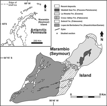
In an attempt to collect more information concerning this important event and to improve our knowledge of the Eocene–Oligocene transition in Antarctica, during January and February 2008 we searched in detail the uppermost edge around the flat-topped meseta at Isla Marambio (Fig. 1) where the supposed Eocene–Oligocene glacigenic deposits were described by Ivany et al. (Reference Ivany, Van Simaeys, Domack and Samson2006). While unsuccessfully searching for evidence of the described Palaeogene glacial interval we discovered two new small diamictite outcrops (Fig. 1) resting on top of the Eocene La Meseta Formation and below the Pliocene–Pleistocene Weddell Sea Formation that could be correlated with the supposed Eocene–Oligocene glacial deposits. The aim of this paper is to describe these rocks and to report their Late Miocene age based on isotopic analyses of a basalt clast and marine invertebrates collected from these sediments.
Map showing study localities.

Geological setting
Isla Marambio
Isla Marambio is located off the north-eastern tip of the Antarctic Peninsula (Fig. 1) and is unique in lacking a permanent ice or snow cover, allowing study of the thick Late Cretaceous–Palaeogene sedimentary succession cropping out there (Marenssi et al. unpublished). The Eocene La Meseta Formation (Elliot & Trautman Reference Elliot and Trautman1982, Marenssi et al. Reference Marenssi, Santillana and Rinaldi1998), exposed on the north-eastern third of the island, consists of fossiliferous, shallow-marine sandstone, mudstone, and shell banks that accumulated in a composite incised valley cut down on the shelf (Sadler Reference Sadler1988, Porębski 1995, Marenssi et al. Reference Marenssi, Net and Santillana1998, Reference Marenssi, Santillana and Rinaldi2002). The unit is unconformably covered by Pliocene–Pleistocene glaciomarine deposits of the Weddell Sea Formation (Zinsmeister & De Vries Reference Zinsmeister and De Vries1983, Gaździcki et al. 1992).
Glacial and marine postglacial Neogene deposits have been described in the nearby islands (e.g. James Ross and Vega islands). An up to date summary of these units has been published recently by Hambrey & Smellie (Reference Hambrey and Smellie2006), Concheyro et al. (Reference Concheyro, Salani, Adamonis and Lirio2007 and references therein) and Hambrey et al. (Reference Hambrey, Smellie, Nelson and Johnson2008). The oldest Neogene rocks correspond to the Hobbs Glacier Formation (Pirrie et al. Reference Pirrie, Crame, Riding, Butcher and Taylor1997) consisting mainly of diamictites. The outcrops of this unit are discontinuous along the coast of the James Ross and Vega islands. About half of the described sections are just one metre to a few metres thick, with few of them thicker than 10 m (Smellie et al. Reference Smellie, Mcarthur, Mcintosh and Esser2006, Hambrey et al. Reference Hambrey, Smellie, Nelson and Johnson2008). They are dominated by silt-rich diamictites or less often diamicton, but some deposits include sandy conglomerates. Clasts are mainly abraded (subrounded to subangular), facetted and less commonly striated. Clasts derived from the James Ross Island Volcanic Group dominate the pebble to boulder population; gravel-size clasts are mainly volcanic glass. Non-volcanic clasts are also present in most of the outcrops. Bivalve fragments, serpulids and bryozoans are present and locally abundant at several localities (Smellie et al. Reference Smellie, Mcarthur, Mcintosh and Esser2006, Concheyro et al. Reference Concheyro, Salani, Adamonis and Lirio2007). A glaciomarine origin close to a glacier terminus was suggested for the lower (diamictite) member of the Hobbs Glacier Formation (Smellie et al. Reference Smellie, Mcarthur, Mcintosh and Esser2006).
Dingle & Lavelle (Reference Dingle and Lavelle1998) indicated an age of 9.9 +/- 0.97 Ma based on SIS stratigraphy from barnacle plates collected in the Hobbs Glacier Formation at Rabot Point (James Ross Island). This Late Miocene age is the oldest Neogene age obtained on James Ross Island so far, although the use of barnacle-carbonate has not been validated for Sr isotopic dating yet the age of this specimen may or may not accurately date an interglacial period. Jonkers et al. (Reference Jonkers, Lirio, Del Valle and Kelley2002) obtained a 40Ar/39Ar age of 9.2 Ma on a fresh basalt lava clast in a younger (6.8 m.y.) diamictite from Fjordo Belén, James Ross Island (Jonkers Reference Jonkers1998, Lirio et al. Reference Lirio, Nuñez, Bertels Psotka and Del Valle2003, Concheyro et al. Reference Concheyro, Salani, Adamonis and Lirio2007). It was the oldest age obtained from the James Ross Island Volcanic Group until now (Sykes Reference Sykes1988, Kristjánsson et al. 2005, Smellie et al. Reference Smellie, Johnson, Mcintosh, Esser, Gudmunsson, Hambrey and Van Wyk De Vries2008).
Recently, Ivany et al. (Reference Ivany, Van Simaeys, Domack and Samson2006) reported 5–6 m thick glacial deposits that conformably overlie typical marine sandstones of the La Meseta Formation but are beneath glacial diamictite of the younger Weddell Sea Formation on the north-west side of the island (locality reported at 64°14′S, 56°37′W). Based on dinocyst stratigraphy and strontium isotope data these authors suggested an age of 33.57–34.78 Ma for these glaciomarine deposits. The supporting marine Sr dates (Dingle & Lavelle Reference Dingle and Lavelle1998, Dingle et al. Reference Dingle, Marenssi and Lavelle1998, Dutton et al. Reference Dutton, Lohmann and Zinsmeister2002) come from the uppermost undisputed sandstones of the underlying La Meseta Formation (latest Eocene). The glaciomarine deposits described by Ivany et al. (Reference Ivany, Van Simaeys, Domack and Samson2006) lack basaltic clasts. Although a lack of basaltic clasts could be used as a criterion for an Oligocene age, given the age of onset of James Ross Island volcanism, Miocene pebbly sandstones from the vicinity are also lacking in volcanic clasts. The dynocyst assemblage recovered from the glacigenic unit permitted Ivany et al. (Reference Ivany, Van Simaeys, Domack and Samson2006) to suggest a glacial event at or very shortly after the Eocene–Oligocene boundary. However, Concheyro et al. (Reference Concheyro, Salani, Adamonis and Lirio2007) suggested that such dinoflagelates belong to the underlying La Meseta Formation and later reworked into the Weddell Sea Formation. If a Late Eocene–Early Oligocene age is correct for the described glaciomarine unit it may resolve the question of diachronism, suggesting that initial expansion of ice on Antarctica encompassed the entire continent synchronously in the earliest Oligocene as postulated by Ivany et al. (Reference Ivany, Van Simaeys, Domack and Samson2006). However, if the glacigenic deposits described by Ivany et al. (Reference Ivany, Van Simaeys, Domack and Samson2006) and the ones reported here could be correlated it may support a younger date for the first glacial event in the region age as suggested by Concheyro et al. (Reference Concheyro, Salani, Adamonis and Lirio2007).
Field sites and sedimentology
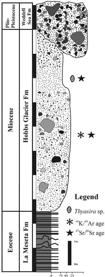
The rocks reported here rest on an erosional unconformity on top of the La Meseta Formation and are unconformably covered by glacimarine rocks of the Weddell Sea Formation. Section A is located at the south-eastern corner of the meseta (GPS S 64°15′32.8′′W 56°38′54.6′′) and is 7 m thick with most of its base covered by alluvium. Small isolated outcrops of similar lithology appear along the southern edge of the plateau for approximately 200 m. The top of the unit is a sharp contact with the Weddell Sea Formation diamictites (Figs 2 & 3a). Section B is located at the south-western edge of the plateau (GPS 64°15′27.6′′W 56°39′24.5′′) and is 15 m thick. The base is unconformable on top the Eocene La Meseta Formation sandstones with soft sediment deformation and its top is the unconformity with the Weddell Sea Formation (Fig. 2).
Stratigraphic section of the described outcrops showing location of dated samples.

Although their stratigraphic position is similar to the glacigenic section described by Ivany et al. (Reference Ivany, Van Simaeys, Domack and Samson2006), none of the outcrops described here match or are close to the GPS location provided by Ivany et al. (Reference Ivany, Van Simaeys, Domack and Samson2006), but they are on the opposite side of the plateau instead.
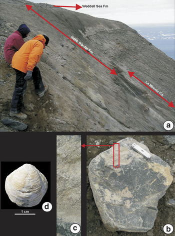
Two main lithofacies are present: a lower 10 m-thick massive matrix-supported diamictite and an upper 5 m thick pebbly sandstone. The diamictite consists of 15–20% of clasts from up to 50 cm in length (Fig. 3b) although the highest frequency belongs to those in the range 10–15 cm. Clasts of plutonic, metamorphic and basaltic composition are mostly angular to subrounded and some are faceted. The matrix is greyish silty sand. The sand content increases upwards as the frequency (and size) of clasts diminishes in a transition to the pebbly sandstone facies containing scattered gravel clasts and marine fauna. Well-preserved bryozoan colonies are frequent on the upper and lateral surfaces of the clasts (Fig. 3b & c). The pebbly sandstone is composed of massive fine sand with scattered pebble and cobble sized clasts and few bivalves (Thyasira sp. a deep-burrower veneroid - Fig. 3d), some of them in living position. The difference in thickness from section A to B and the absence of this deposit around the meseta suggest a lenticular geometry. Massive muddy to sandy diamictite, with facetted clasts (mostly plutonic and metamorphic) up to 50 cm long and marine fauna (bivalves in living position) suggest resedimentation of glacial derived debris in a marine environment. The existence of facetted, pentagonal and some striated clasts supports the proposed glacial or inherited glacial origin. However, there is no clear evidence of direct ice deposition (tillite) and the presence of marine fauna suggests a marine environment with episodic influx of remobilized material of glacial origin.
a. General view of the glacigenic section at locality “A” (note well-bedded sediments of the La Meseta Formation below and coarse-grained chaotic sediments of the Weddell Sea Formation above), b. clast of fine-grained metamorphic rock bearing encrusting bryozoans in diamictite facies, scale = 10 cm, c. close-up of the metamorphic rock clast showing the bryozoan colonies, d.Thyasira sp.

Living Thyasira species prefer dark clay/mud substrates without coarse clastic debris and some species live in fine- to medium-grained sand (López-Jamar & Parra Reference López-Jamar and Parra1997, Cacabelos et al. Reference Cacabelos, Quintas and Troncoso2008). Many Thyasira species are able to live in oxygen-poor or hydrogen sulphide-rich substrates in areas of low productivity which ecologically exclude many other infaunal bivalves. Presently, higher diversity and abundance of Thyasira are found in the outer part of the inner sub-littoral zone and the outer sub-littoral zone of continental shelves between 30° and 55° north or south latitude (Kauffman Reference Kauffman1969).
Age determination
A basaltic clast bearing encrusting bryozoans from the diamictite in the lower part of section B, and one specimen of Thyasira sp. (Fig. 3d) recorded in living position in the sandy facies from section A, were selected and sent for isotopic analyses at Activation Laboratories Inc. (Canada). Field relationships suggest that section A overlies section B with some overlapping (Fig. 2).
The basalt clast was dated by whole rock 40K/40Ar while the bryozoan colony and the bivalve shell were analysed to obtain high resolution 86Sr/87Sr data. For K–Ar dating the K concentration was determined by ICP. The Ar analysis was performed using the isotope dilution procedure on noble gas mass spectrometer (Table I).
Analytical data provided by Activation Laboratories Inc. (Ontario, Canada) for whole rock 40K/40Ar age determination of the basalt clast.

For the Sr isotope analysis the Rb and Sr were separated using conventional cation-exchange techniques. The analysis was performed on Triton a multi-collector mass-spectrometer in static mode, during which the weighted average of 15 SRM-987 Sr-standard runs yielded 0.710258 ± 8 (2 s) for 87Sr/86Sr. The strontium data were converted to numerical ages using the SIS LOWESS v.3.10 (McArthur et al. Reference McArthur, Howarth and Bailey2001), with minimum, most probable and maximum ages for each sample shown in Table II.
Analytical data provided by Activation Laboratories Inc. (Ontario, Canada) on the high resolution 86Sr/87Sr analyses performed on the bivalve shell and bryozoan colony. +/- 2s is for two-sigma error. Derived ages are from McArthur et al. Reference McArthur, Howarth and Bailey2001.

Although minor inconsistencies may arisen from the different dating techniques and the uncertainties from the SIS, the calculated absolute ages show that the bryozoans colonized the surface of the basalt very soon after it was erupted around 12.4 Ma but certainly the bivalves colonized the sandy substratum much later around 9 Ma.
Discussion
The lithology, fossil content and obtained ages suggest strongly that these rocks belong to the Hobbs Glacier Formation and support a Late Miocene age for this unit. The age of the in situ bivalves coincides well with that reported by Dingle & Lavelle (Reference Dingle and Lavelle1998) and supports an interglacial period at around 9 to 10 Ma.
The age of the basaltic clast, possibly one of the oldest yet reported for the James Ross Island Volcanic Group (JRIVG), and the age of its encrusting bryozoan colony suggest that the basalt was colonized shortly after its eruption. The uncertainties of both SIS and 40K/40Ar dating techniques precludes any attempt to exactly relate the events but as the basalt must predate the encrusting bryozoan and only the upper surface and edges of the observed basalt clasts are colonized we conclude that basaltic eruption, glacial erosion, transport, sedimentation and colonization may have occurred within a short time (maybe 1 million years). In any case the onset of the glacial event must have happened at (subglacial volcanism?) or shortly after 12.4 Ma. After that event, an ameliorating (interglacial) period took place in the region at least some 10 to 9 Ma ago.
The basaltic volcanism of the JRIVG is composed of several lava-fed delta sequences and some pyroclastic cone outcrops, which overlie generally poorly consolidated Cretaceous marine sedimentary rocks (Smellie et al. Reference Smellie, Johnson, Mcintosh, Esser, Gudmunsson, Hambrey and Van Wyk De Vries2008 and references therein). Recently, Smellie et al. (Reference Smellie, Johnson, Mcintosh, Esser, Gudmunsson, Hambrey and Van Wyk De Vries2008) provided sixty-nine 40Ar/39Ar isotopic age determinations from samples of in situ volcanic units of the JRIVG from James Ross Island and nearby localities. They range from 6.16 Ma to less than 80 ka allowing a refining of the knowledge of the age and number of eruptive events previously known (Sykes Reference Sykes1988). However, Jonkers et al. (Reference Jonkers, Lirio, Del Valle and Kelley2002) have previously obtained a single 40Ar/39Ar age of 9.9 Ma on a fresh clast of basalt collected in a diamict from northern James Ross Island. The 12.4 ± 0.5 Ma age shed by 40K/40Ar dating of the here reported basalt clast is the oldest ever recorded for the JRIVG. Thus, eruptions of the JRIVG extended between 12.4 Ma and present (Sykes Reference Sykes1988, Jonkers et al. Reference Jonkers, Lirio, Del Valle and Kelley2002, Kristjansson et al. 2005, Smellie et al. Reference Smellie, Johnson, Mcintosh, Esser, Gudmunsson, Hambrey and Van Wyk De Vries2008) although it seems that the rocks of the oldest volcanic events are either not cropping out (or been sampled yet) or have been eroded by glacial processes. In this later case, and according with the suggestion of Smellie et al. (Reference Smellie, Johnson, Mcintosh, Esser, Gudmunsson, Hambrey and Van Wyk De Vries2008), the entire area might have been overrun by the Antarctic Peninsula Ice Sheet (APIS) during the earliest stages of the JRIVG volcanism. Sytematic dating and geochemical analysis of JRIVG derived clast from the Hobbs Glacier Formation may provide significant data for understanding the timing and geotectonic setting of the earliest stages of the JRIVG volcanism and its relationship with the development of the APIS.
Ivany et al. (Reference Ivany, Van Simaeys, Domack and Samson2006) described two pebbly mudstone lithofacies with an intervening diamictite. The lower unit consists of 2–3 m thick of dark brown-grey, compact, stratified, silty mudstone containing a significant fraction of coarse sand grains, pebbles, and occasional outsized clasts several centimetres in diameter is truncated by a dense compact diamict entirely unsorted exhibiting no evidence of stratification, grading, or other internal architecture that ranges from 1 m to 2 m in thickness. Cobbles and pebbles are polished and occasionally striated, faceted, and/or streamlined in shape. The diamict is overlain by another pebbly mudstone (although according with the grain-size distribution shown in their fig. 2 at least one of the samples is a sandstone), also with outsized clasts (the reported “possible dropstones” are very difficult to assert without impact structures), and the entire section is disconformably truncated by the Weddell Sea Formation. They do not record basalt clasts or whole bivalve shells.
Despite our efforts for revisiting the outcrop described by Ivany et al. (Reference Ivany, Van Simaeys, Domack and Samson2006) we were not able to locate their section. The GPS location provided is of very low accuracy and does not allow locating the described section. The reported “persistent poor weather” prevented these authors for further exploration of its lateral extent and therefore they were unable to find the thicker glacigenic deposits described in this paper. Even though the similar stratigraphic position, the essential differences between the section described by Ivany et al. (Reference Ivany, Van Simaeys, Domack and Samson2006) and the rocks reported here are the lack of basaltic clasts and the presence of Oligocene dynoflagellates in the former.
Therefore, the here described diamictite cannot be confidently correlated with the glaciomarine unit previously assigned to the Late Eocene–Lower Oligocene. Notwithstanding this, it is now evident that there are likely to be more, short but important, stratigraphic sequences of key regional and Antarctic wide interest preserved on the plateau of Seymour Island that deserve to be carefully studied.
Acknowledgements
We wish to thank Dirección Nacional del Antártico and Fuerza Aérea Argentina for their logistic support. This research was partly funded by National Geographic Society grant 8279-2007 to SAM. We would also thank the very constructive reviews of Drs Anna Nelson, Pat Quilty and Alan Vaughan that helped to improve the original manuscript