


Introduction
On 2 September 1934, Sucesión J. Serrallés, a wealthy Puerto Rican azucarero,Footnote 1 wrote the island's governor a scathing critique of proposed legislation that would regulate the irrigation system that flooded his canefields. His target was the Puerto Rican government's latest effort to control malaria on the island. It required, among other things, that irrigation reservoirs and canals be drained periodically to disturb mosquito breeding sites. This infuriated the azucarero class, whose fields depended on irrigation. Serrallés declared: ‘the proposed regulation which would require that all reservoirs be drained each week could have originated only with someone not acquainted with conditions on the South Coast’. Southern Puerto Rico is relatively dry compared to the rest of the island and irrigation was essential to commercial agriculture there. Serrallés continued, ‘the suggestion is so far out of line with the requirements of the dry section that it could not be given serious consideration by anyone knowing the facts’. For Serrallés, it was clear: irrigated sugarcane fields undergirded the island's economy and generated tidy profits for azucareros and large sugar companies. Malaria was part of the price of doing business. He concluded, ‘the scourge [malaria] has been with us for centuries and it cannot be eliminated by any drastic upsetting of the economic life of the irrigated districts’.Footnote 2
Malaria had indeed been endemic in Puerto Rico for centuries but its dominance in the south-east irrigation district was recent and mostly attributable to irrigation.Footnote 3 Large irrigation dams were novelties on the island. Between 1910 and 1914 the Puerto Rican Irrigation Service built the first three large dams in the south-east to water the canefields of absentee US corporations and a few wealthy Puerto Rican azucareros, including Serrallés. These three dams, Guayabal, Carite and Patillas, along with two smaller ones, Coamo and Melania, formed the South Coast Irrigation Project (SCIP). The project doubled sugar production in the decades following its completion in 1914.
SCIP also brought a swarm of unforeseen consequences. These large dams were the first built in the Caribbean with US engineering expertise. The warm and humid climate posed new challenges to US and Puerto Rican engineers, who failed to anticipate irrigation's implications for public health. Malaria rates in the irrigation district soared alongside sugar production, and after 1914 the island's malaria epicentre shifted to the south-east. The irrigation system created ideal habitats for Anopheles albimanus, malaria's principal vector on the island.Footnote 4 These mosquitoes proliferated in vegetation-choked irrigation canals and holding reservoirs as well as in wet canefields and stagnant pools that formed when canals overflowed after heavy rains. Meanwhile, the demand for fieldworkers encouraged huge migrations of Puerto Ricans to the southern coastal plains. Many of these workers came from the mountainous interior and had little prior exposure to malaria. They and their families typically settled in unscreened houses close to irrigated canefields and their associated mosquito breeding grounds, or near natural habitat for An. albimanus, such as coastal mangrove swamps and seepages.
As malaria rates climbed in the irrigated south-east in the 1920s and 1930s, Puerto Rican public health officials, with the help of the Rockefeller Foundation, tried to find economic ways to combat malaria. Draining seepages and mangrove swamps and spraying a potent insecticide called ‘Paris green’ destroyed mosquito breeding grounds, but these measures were insufficient. In 1938 the Puerto Rican government – despite Serrallés’ wishes – passed legislation that required azucareros to clean their canals to reduce mosquito habitat. However, the most severe restrictions were amended, and the law was loosely enforced. Malaria incidence declined slightly but the disease was not controlled.
Effective malaria control came only with wartime pressures and DDT spraying. The Puerto Rican Public Health Service stepped up malaria control efforts during the Second World War and began spraying DDT in the late 1940s, all but eliminating malaria by 1953. The fact that Puerto Rico was an island, and isolated from infected populations outside its borders, helped ensure that DDT spraying was successful against mosquitoes, thereby annihilating malaria. At ports the government could exercise stronger vigilance against the reintroduction of malaria, even if mosquito populations rebounded, than other countries could at more porous terrestrial borders.
But shifts in the island's economic base and the associated demographic trends were equally important in eradicating the disease. Demand for cane had dropped steeply during the Great Depression, but rebounded in the 1940s. Sugar continued to dominate the island's economy in the immediate post-war period.Footnote 5 Sugar remained important through the 1960s but lost its foremost position in the 1950s as the island industrialised. As the sugar industry became mechanised and urban centres offered employment, more people moved away from irrigated canefields and into towns and cities. The ongoing trend helped ensure that malaria did not rebound after DDT campaigns ended. Thus, it was not until irrigated canefields lost their prominence in the island's economy that public health officials succeeded in lifting the malaria burden. In 1962 the World Health Organization (WHO) declared Puerto Rico the first tropical territory in the Americas, and perhaps the world, to have successfully eradicated malaria. In Puerto Rico, malaria rose with the commitment to irrigated canefields and remained tenacious until wartime exigencies inspired greater control efforts, DDT became available and, most importantly, manufacturing eclipsed sugar production as the island's dominant economic activity.
Historians, Dams and Malaria
The Puerto Rican sugar industry has inspired a rich body of scholarship focused on the island's economic and political history.Footnote 6 Likewise, the sugar boom has produced rich social histories. Most notably, anthropologists Julian Steward and Sidney Mintz conducted fieldwork on the south-eastern sugar lands, which highlighted the economic and political impact of US occupation and the inclusion of Puerto Rican sugar behind US tariff walls.Footnote 7 These authors also discussed the economic dependence and social inequalities that accompanied the sugar boom. However, this scholarship has not probed the ecological dimensions of the sugar industry at any length.Footnote 8
The environment shaped the early twentieth-century Puerto Rican sugar boom. The rich soils of the alluvial plain were suited for cane production. Although the climate in the south-east was too dry for intensive cane farming, small rivers running from nearby mountains could be dammed to divert water and produce electricity to power groundwater pumps. The irrigated sugar boom in the south-east also came with a host of unintended ecological consequences. Most prominently, canals created ideal habitats for both malaria-carrying mosquitoes and bilharzia-carrying snails. This article deals with the former.Footnote 9
Historians interested in dam-building have not given much attention to the health consequences of dams.Footnote 10 These historians debate the economic, ecological and social consequences of dam construction. Disagreements surround the extent to which dams have destroyed the environment and worsened social inequalities. But dams also create new disease regimes and can frustrate public health efforts because attempts to control diseases, such as malaria, can come into conflict with the economic gains that dams offer.
SCIP demonstrates that dam-building projects have consequences for human health, which vary with climate, land use and political economy. In Puerto Rico, US engineers confronted a climate that was hospitable to malaria-carrying mosquitoes, and mounting malaria rates represented an unforeseen challenge to these mainland engineers. The government built the dams to irrigate the canefields of wealthy sugar companies, the largest of which were from the United States and whose export-oriented agriculture dominated the island's economy. This economic and political context had important consequences for the island's disease regime because malaria control came into conflict with the priorities of the azucarero class and the imperial government, whose financial commitments to irrigation triumphed.
Historians working on disease, rather than dams, have more often discussed the connection between the two.Footnote 11 Margaret Humphreys discusses two early twentieth-century dams, built in the US South, whose construction triggered malaria epidemics. However, the Coosa River dams were built for navigation, and the Santee Cooper dam to generate power, so, unlike the Puerto Rican case, malaria concentrated only around the reservoirs themselves. Malaria was also not as entrenched in the US South during the early twentieth century as it was in Puerto Rico. Lastly, hydropower was important but not as fundamental to the US South's economy as irrigated canefields were to Puerto Rico's economy. Although the initial consequences of dam-building were similar, malaria was much more enduring in Puerto Rico.
This article also builds on the literature about malaria eradication. Since the late 1960s historians have criticised DDT and other scientific solutions to malaria control.Footnote 12 Some historians have highlighted cases where DDT failed outright. Others have argued that spraying was but one factor in successful malaria eradication campaigns; and that demographic or political variables were equally important.Footnote 13 This article follows in the footsteps of Eric Carter, who highlighted the importance of understanding the particularities of different species of anopheles mosquitoes, and Humphreys, who argued that economic and demographic changes were essential to malaria eradication in the mainland United States.
Lastly, this article contributes to historical scholarship on malaria and empire. John McNeill discussed the importance of malaria and yellow fever in the imperial ambitions of European powers in the Greater Caribbean after the 1620s.Footnote 14 Differences in malaria resistance and yellow fever immunity helped Spain retain its American empire until the 1770s, after which they helped American revolutionaries win independence from European imperial powers, undermining the Greater Caribbean's geopolitical order. Similarly, Paul Sutter highlighted linkages between both diseases to US empire-building in Panama. Controlling both diseases was vital to the successful completion of the Panama Canal in 1914. However, as Sutter argues, canal construction created ecological changes that facilitated the spread of both diseases, and the government invested in control because it had an economic interest in protecting its workforce.Footnote 15
In Puerto Rico a different set of imperial interests was at stake. US consumers valued canefields for their sucrose, and sugar companies for their profits. But neither absentee sugar companies nor mainland consumers suffered from malaria. Thus, the clash between efficient irrigation and malaria control, while tied to class interests, was also a conflict between domestic concerns and imperial economics.
Thus, this article builds on five existing bodies of scholarship. It highlights the ecological dimensions of the Puerto Rican sugar boom and adds important insights into the environmental consequences of dam-building and US imperialism. It confirms that, in addition to DDT, other variables, such as demography, were important to the success of malaria eradication. The Puerto Rican case gives this conclusion additional weight because malaria was firmly entrenched and closely tied to the island's leading economic sector: its swampy canefields.
Dams and Sugarcane in the South Coast Irrigation District
Puerto Rico is a mountainous island. The Cordillera Central, the island's principal mountain range, runs east to west and constitutes about 50 per cent of the island's land area (see Figure 1). The highest points of the Cordillera Central are in the south and most rivers flow south to north, emptying on the north coast. Between the mountainous interior and coast are foothills that amount to 25 per cent of the island's surface area. Surrounding the Cordillera Central and its foothills is a thin, flat alluvial plain that makes up the remaining 25 per cent of the land surface and holds the island's best soils.
Shaded Relief Map of Puerto Rico

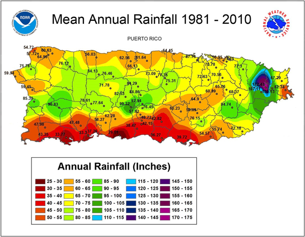
Puerto Rico has a tropical climate and the north-east trade winds supply the north and central parts of the island with heavy rainfall for half the year. However, rain does not fall in such high quantities on the southern coastal plains, which sit in the rain shadow of the Cordillera Central (see Figure 2). Although south-eastern soils were excellent for agriculture, they lacked sufficient water for large-scale cultivation. Redistributing water from the mountains to the relatively dry plains held great promise and excited the imagination of irrigation enthusiasts, but no such project garnered support under Spanish rule.Footnote 16 In 1866, English engineer E. B. Webb proposed damming Río de la Plata at a site known as Carite Valley and diverting the water south, through a tunnel in the mountains, to irrigate the southern coastal plains. The Spanish government approved the scheme but never built it.Footnote 17
Mean Annual Rainfall of Puerto Rico, 1981–2010

Changing economic conditions after the Spanish-American War helped rekindle interest in irrigation. In 1901 the US government eliminated the tariff barrier on Puerto Rican sugar, provoking a boom in cultivation.Footnote 18 US sugar companies flooded the island with capital, and cane quickly became the principal export and economic activity, giving Puerto Rican and US azucareros greater political influence on the island.Footnote 19 Sugar was booming, but recurring drought in the south-east after 1898 hindered the azucareros’ efforts there. They saw reviving Webb's irrigation scheme as the solution.
The azucareros’ irrigation plans found a receptive political climate after 1898, when the US government took over administrative control of Puerto Rico. Under the colonial administration, the president appointed the governor and his cabinet, which meant that Puerto Ricans had minimal political participation. Legislation was designed and implemented to favour US corporate interests.
SCIP was no exception. It would water the canefields of Aguirre Sugar Co., one of four large, vertically-integrated US corporations in Puerto Rico, all concentrated in the south and east, that together produced 50 per cent of the island's cane in the first decades of the twentieth century. Taxes on irrigation water, the primary means of generating revenue to meet SCIP's bond payments, made irrigation expensive, but Aguirre had the capital to foot the bill. Indeed, after the project was completed Aguirre profited immensely and had no problem meeting payments. The company came to own or lease 39,000 of the irrigation district's 48,000 acres and ran the south-east's three largest sugar mills, or centrales: Aguirre, Machete and Cortada.Footnote 20 The Foraker Act (1900) and the Jones Act (1917) limited the amount of land that a corporation could hold to 500 acres, but this provision was widely ignored until the 1930s and 1940s.Footnote 21 Thus, the colonial government's irrigation system was designed to shore up profits for a US corporation.
In 1908 the Puerto Rican government issued bonds for surveys of the island's first major irrigation project, to be carried out by engineers of the US Reclamation Service. The following year the government issued a US$3 million bond for further surveys and construction.Footnote 22 The project, which became SCIP, was the first ambitious irrigation scheme on the island and entailed the construction of the first three large dams built with reinforced concrete. It was undertaken with the explicit purpose of irrigating canefields.Footnote 23 When finished in 1914, SCIP's three large dams created the first large standing bodies of fresh water on an island that has no natural lakes.
By the mid-1920s, SCIP was irrigating 48,000 acres on Puerto Rico's south-eastern alluvial floodplain. The floodplain totalled 75,000 acres, 40 miles in length and no more than three miles in width.Footnote 24 The project was divided into eastern and western sections and consisted of three principal dams and two much smaller ones. The Guayabal dam, the chief feature of the western section, had a reservoir with a storage capacity of around 9,500 acre-feet. Carite, one of the two main dams of the eastern section, had a similar storage capacity. Patillas, the second dam in the eastern section, was the biggest and most expensive dam of the entire project, with a storage capacity of 14,531 acre-feet.Footnote 25
The dams and reservoirs provided a huge boon to the sugar industry. From 1909 to 1915 the average annual sugar harvest in the lands to be irrigated was approximately 54,000 tons. From 1916 to 1930 the average in the south-eastern irrigation district reached 104,000 tons.Footnote 26 Sugar production suffered in the 1930s during the Great Depression but rebounded after the Second World War. In 1948 anthropologist Sidney Mintz, who was living and doing research in Barrio Jauca on the southern coast of Puerto Rico, remarked on the exuberant growth of the canefields. He wrote that as the cane matured it turned the coastal plain into ‘a hot, impenetrable jungle, broken only by special pathways and irrigation ditches … all the time I was in Barrio Jauca, I felt as if we were on an island, floating in a sea of cane’.Footnote 27 Although he wrote in the 1940s, Mintz's remarks are undoubtedly fitting for the 1920s and 1930s as well. Irrigation had turned the south-eastern coastal plain into a giant canefield.
The sugar boom in south-eastern Puerto Rico was part of an expansion in sugarcane production throughout the Caribbean between 1898 and 1934. Increasing US capital and influence in Cuba and Puerto Rico after the Spanish-American War contributed to this growth. Furthermore, the First World War destroyed much of the European sugar beet industry, which had competed with Caribbean cane sugar since the middle of the nineteenth century. In 1921 Cuba, the Dominican Republic and Puerto Rico together produced 38 per cent of the world's cane sugar and 27 per cent of all sugar produced.Footnote 28 Although Cuba accounted for most of this production, Puerto Rican sugar held a large share of the US market because it entered the United States tariff-free. By the 1930s, Puerto Rico provided around 15 per cent of the raw sugar in the US market.Footnote 29
Malaria in the South Coast Irrigation District after 1914
The land use changes brought about by SCIP shifted the island's malarial epicentre to the southern sugar lands. But by the late 1930s and early 1940s the irrigation district, which previously had scarcely hosted malaria at all, now had the highest rates of malaria on the island and the south coast became a principal target of the malaria control campaigns.
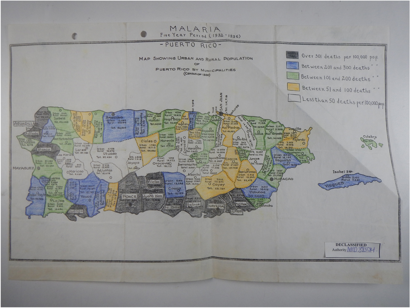
Comparing average mortality rates by district in the 1930s highlights the heavy malaria burden in the south-east. In 1938 the Department of Health reported that the average annual death rate from malaria in Puerto Rico was 160 per 100,000.Footnote 30 In the south-east, death rates were dramatically higher. According to health officials, there they were as high as 600, and sometimes 850, per 100,000. The hand-drawn map accompanying this report provides a lower death rate of 301 per 100,000 in the south-east (see Figure 3).Footnote 31 Depending on which estimate one follows, the malaria burden in the south-eastern sugar lands in the 1930s was approximately double and perhaps quadruple the island-wide average.
Malaria Mortality Rates in Puerto Rico, 1932–6

Indeed, mortality rates from malaria were so high in the south-east that a visiting doctor claimed, ‘the size of this area [the south-eastern coastal plain] and the intensity of the infection so overshadows any other portion that it creates the impression that the malaria problem is confined to the arid irrigated south coast’.Footnote 32 To be sure, malaria was not confined completely to the southern sugar lands. Other lowland coastal areas, especially those planted to cane, were major malaria foci as well.Footnote 33 However, malaria was most tenacious in the south-east and rates there outstripped those anywhere else on the island.
Prior to 1914, the south-east was almost surely low in malaria rates by Puerto Rican standards. Unfortunately, malaria rates by municipality were not recorded until 1916. But, the south coast, as one of the driest areas on the island, was not ideal real estate for the malaria-carrying mosquitoes. Although An. albimanus, the principal malaria vector in Puerto Rico, breed in pooled water in dried riverbeds, they are otherwise not well adapted to dry conditions.Footnote 34
It is also likely that zooprophylaxis curbed malaria.Footnote 35 Zooprophylaxis is a condition whereby animal populations attract mosquitoes that prefer animal blood away from people, disrupting the life cycle of malaria parasites – which cannot reproduce in most animal bodies – thus reducing malaria transmission. An. albimanus have a strong preference for cattle and horse blood,Footnote 36 and cattle ranching was the principal economic activity on the southern coastal plains prior to 1914. In 1909 there were 33,592 large animals (mostly cattle and horses) in the municipalities that later formed the irrigation district, and 91,637 people.Footnote 37 The presence of so many large animals in an area that had few albimanus mosquitoes to begin with likely helped to keep malaria rates low since any infected mosquitoes preferred animal hosts to humans. Thus, prior to construction of SCIP in 1914, conditions in the south-east would have kept the population of malaria-carrying mosquitoes low,Footnote 38 and the presence of large animals would have limited human infection.
In contrast, the irrigated sugar lands provided excellent habitat for mosquitoes and malaria transmission. During the dry season there was stagnant water in irrigation canals and canefields. These irrigation canals, and the shores of holding reservoirs themselves, were often chocked with debris, algae and aquatic weeds that provided excellent habitats for An. albimanus (see Figure 4). During the wet season, floods and heavy rains increased spillage from irrigation canals, creating stagnant pools of water, ideal for mosquitoes.Footnote 39 Thus, according to Dr Walter Earle, the Rockefeller Foundation's chief malaria expert in Puerto Rico, ‘irrigation of canefields [on the south coast] has complicated the [malaria] problem by supplying breeding places during otherwise dry months and increasing the breeding area during the wet months’.Footnote 40 Irrigated canefields transformed the southern coastal plain from a dry and inhospitable place for mosquitoes to swampy lands ideal for breeding.
Photograph Taken in 1920 Showing an Irrigation Canal in the South Coast Irrigation District

To be sure, irrigation did not make soaring malaria rates inevitable. Malariologists in Puerto Rico argued that with proper management irrigation need not engender malaria. Irrigation water was applied to canefields only once every two to three weeks, and water often did not sit on the fields for more than two to three days at a time. Malariologists reasoned that since it takes albimanus mosquitoes eight to ten days to mature, stagnant water lasting a few days did not facilitate mosquito population explosions.Footnote 41 Additionally, there were steps azucareros could take to reduce albimanus breeding. Irrigation canals built with concrete and clean shorelines minimised breeding opportunities.Footnote 42 The island's malariologists were confident these steps could all but eliminate the disease.
But in practice irrigation was much more difficult to control. Proper management was labour-intensive and expensive. Although some irrigation canals sat dry for short periods between the two-to-three-week application intervals, the main canals and holding reservoirs held water consistently.Footnote 43 And, though some irrigation canals were kept clean, others filled with debris. Fields were not always drained properly and, despite efforts to contain seasonal floods, water spilled out of irrigation canals, forming swampy pools. Even Dr Earle, the foremost advocate of the view that irrigation and malaria control were not inherently at odds, conceded that ‘malaria control is always more difficult where irrigation is practiced’.Footnote 44
In addition, demand for labour in booming canefields drew migrants to the southern coastal plains, which put more people in contact with the growing swarms of mosquitoes at a distance from protective animal herds. Between 1910 and 1930 the population in the irrigation district grew from 91,627 to 107,974.Footnote 45 As ranching declined, the ratio of cattle to humans fell, reducing the zooprophylactic effects of animals.Footnote 46 More importantly, workers and their families moved to towns and labour colonies clustered around canefields, irrigation canals and associated mosquito breeding sites (see Figure 5). Commenting on the dramatic increase in workers on the coastal plain, Dr Earle noted in 1926 that ‘the population in most of these regions is distributed more or less densely throughout and in close contact with swampy and irrigated regions’.Footnote 47 Even the south coast's principal cities were located within two miles of the irrigated canefields, which put them within range of albimanus mosquitoes.Footnote 48
Photograph Taken Circa 1924–5 Showing Canefields and Rural Homes in the South Coast Irrigation District

Not only were workers exposed to breeding sites created by the irrigation infrastructure, but they often relocated to land near natural breeding sites. Many of the south coast's canefields and towns were located near mangrove swamps and seepages.Footnote 49 Take, for example, the town of Salinas, which was adjacent to two mangrove swamps, as well as wet canefields and holding reservoirs.Footnote 50 Since the best land was planted to sugar, only the most marginal land was available for building houses.Footnote 51 According to Dr Earle, ‘nothing but the swamp lands and beaches [were] left for sites for building’.Footnote 52 The wooden houses on such marginal land were unscreened and often built hastily with gaps in the walls. They were so crowded that residents often slept outside.Footnote 53
Many of these people were from mountain regions and would have been particularly vulnerable to malaria. Those repeatedly exposed to malaria acquire resistance to it. Malaria had been endemic in Puerto Rico since the sixteenth century, meaning Puerto Rican workers living near wet canefields would likely have been repeatedly exposed to the disease as children and built up some resistance to it. But many of the fieldworkers in the south coast after 1914 were from the coffee-growing regions in the interior.
Between the 1850s and 1890s large numbers of Puerto Ricans had moved into the mountains to work on coffee plantations.Footnote 54 Coffee grows well at high elevations and thrived in the tall Cordillera Central. Coffee became the principal export crop of Puerto Rico in the second half of the nineteenth century and the highlands became the economic and demographic centre of the island.
Morbidity statistics were not collected between the 1850s and 1890s, but malariologist John B. Grant's island-wide malaria survey in 1920 suggests malaria was rare on the highland coffee estates. In Utuado, Puerto Rico's principal coffee-growing district, none of the 51 people Grant examined had malaria. In contrast, in Salinas, one of the municipalities in the south coast irrigation district, Grant found that 19 out of 54 people tested positive for malaria, a morbidity rate of 35 per cent.Footnote 55 Grant's findings were widely confirmed: other medical officers echoed his conclusion that malaria was rare in the mountainous districts.Footnote 56 Indeed, albimanus mosquitoes prefer lowlands. They are most often found between zero and 50 metres elevation and rarely go above 100 metres.Footnote 57 Many of the Cordillera Central's towns sit above 100 metres, including Utuado, at 142 metres. Not only do An. albimanus dislike high altitudes but they find fewer breeding sites in the mountains. The steep slopes of the interior are not conducive to the formation of standing bodies of water. Thus, those Puerto Ricans living in the highland coffee districts between 1850 and 1910 would have had minimal exposure or resistance to malaria.
Coffee production collapsed after 1898 with the loss of Spanish tariff protection.Footnote 58 After 1898, the Cuban and Spanish market for Puerto Rican coffee disappeared. The United States did not grant special tariff protection for Puerto Rican coffee, which fell into decline and was overtaken in economic importance by sugar.
This economic shift encouraged migration from the highlands to the lowland canefields between 1898 and the 1910s. Many migrants ended up in the south coast irrigation district. Census data highlights this trend. For example, consider the same two municipalities that Grant compared in his 1920 study on malaria: Utuado, the island's principal coffee-growing municipality, and Salinas, on the irrigated south coast. Between 1899 and 1920 Utuado's population decreased from 43,860 to 35,135. During the same period, the population of Salinas more than doubled, from 5,731 to 12,971.Footnote 59 Despite some exceptions to this pattern,Footnote 60 it is clear that, broadly speaking, between 1898 and the 1910s, large numbers of workers moved south from the highlands.
That these workers were entering a new disease landscape was not lost on contemporaries. One medical doctor suggested that, in addition to irrigation, the principal cause for such high rates of malaria in the south coast was the ‘shift of population from the destroyed coffee-growing sections of the mountain districts to the cane-growing sections of the coastal plains’.Footnote 61 Howard Green, a prominent Rockefeller Foundation malariologist, also found that the ‘extensive movement of people exposed large numbers of those from the mountains to infections when residing on the coast’.Footnote 62 In short, workers born or brought up in the highlands would have acquired minimal resistance to malaria and been more susceptible to the disease in irrigated canefields.
By the 1930s, many fieldworkers and their families had developed malaria resistance. In 1937, the Puerto Rican Reconstruction Administration (PRRA) published a survey of the socio-economic and health conditions of Central Lafayette and its surrounding canefields.Footnote 63 Malaria abounded in and around Central Lafayette, accounting for 90 per cent of recorded illness and infection among those surveyed. Yet 86 per cent of those whose blood tests confirmed they carried the malaria parasites showed no symptoms of ill health, suggesting that many fieldworkers and their families had acquired resistance.Footnote 64
Nevertheless, high birth rates and immigration of immunologically vulnerable fieldworkers to the south coast ensured that sickness and death remained common among those infected in the 1930s. The PRRA's survey noted that malaria was the most lethal disease on the south coast's sugar plantations, where its mortality rate was double the island-wide average. Therefore, even though only a small percentage of those infected suffered symptoms, the rate of those sick and dying was still high by island standards.Footnote 65
The disease infected age cohorts roughly in proportion to their percentage of the surveyed population. Young children bore the brunt of the malaria burden partly because they made up a large percentage of the population. Children younger than 14, who were 43 per cent of the surveyed population, accounted for 51 per cent of people either sick or carrying malaria parasites. Those between the ages of 15 and 29, who constituted roughly 30 per cent of the population, made up another 25 per cent of the sick or infected, and those over age 30 made up the last 24 per cent.Footnote 66
The case of Don Taso, a sugarcane fieldworker in Santa Isabel, suggests that malaria plagued much of the working-age population. Reflecting on his childhood in the late 1910s, Don Taso remarked, ‘in that time here at the barrio it was rare to find a house in which there were no people with malaria. You could walk into any house, and always find someone shivering and fevered and vomiting, especially among the children’.Footnote 67 He stressed that the disease afflicted children but remarked that there were also many cases of adults suffering from fevers. Don Taso himself, who started working at age nine, suffered from malarial fevers as a child, and his older sister died from malaria as a young adult.Footnote 68 Despite some acquired resistance among adults, much of the working-age population suffered from malaria.
Differences in susceptibility to malaria can be heritable,Footnote 69 but in Puerto Rico ancestry mattered less than class differences. Those of African descent were less often infected because they were more likely to carry heritable resistance. But regardless of ancestry, the working- and lower-class residents were more likely than the wealthy azucarero class to suffer from malaria because their living and working conditions exposed them to more mosquitoes, and because azucareros could more easily afford quinine, a drug that kills malaria parasites.
In short, after the completion of SCIP in 1914, the relatively dry south-east became the island's most malarious district. The irrigation infrastructure and land use changes associated with soggy canefields created more mosquito habitat and eased malaria transmission, at the same time that the labour demands of cultivation brought more people, some of whom had little prior exposure to the disease, to settle in close proximity to both man-made and natural breeding sites.
Malaria Control and Irrigated Canefields, 1924–41
Between 1924 and 1954 the Puerto Rican government tried to first control and then eradicate malaria.Footnote 70 In the early twentieth century, malariologists around the world debated the relative merits of controlling malaria by improving socio-economic conditions, such as housing and access to medical clinics, against the merits of technical solutions that would destroy the vectors and pathogens themselves. The technical approach was dominant and malariologists of this school further debated whether they would have better success with mosquito extermination or with wide-distribution drugs that would kill the plasmodium itself and stop transmission. By the 1920s the vector-based approach, or ‘species sanitation’, prevailed among US malariologists, including those from the Rockefeller Foundation.Footnote 71
During the 1920s and 1930s, the Puerto Rican Department of Health worked alongside the Rockefeller Foundation to control malaria. In 1919 the Puerto Rican government had invited the Rockefeller Foundation to the island to study tuberculosis. However, the Foundation quickly shifted towards studying tropical parasitic diseases, such as malaria, because fighting these diseases seemed to require no socio-economic change.Footnote 72
In Puerto Rico, mosquito eradication was the principal component of anti-malaria campaigns. The breeding grounds targeted for eradication were mangrove swamps, natural seepages, small holding reservoirs for irrigation water, irrigation and drainage ditches, and stagnant pools in streambeds.Footnote 73 Malaria fighters concentrated their efforts in only a few towns and rural areas thought to represent the worst of the island's malaria problem. Malaria was most deeply entrenched in the south and, although underfunded, the Health Department's Bureau of Malaria Control fought tenaciously to control the scourge there.
Public health officials were unable to eliminate natural breeding grounds. They could neither fill nor drain all the mangrove swamps.Footnote 74 Draining swamps required expensive pumps. In the 1930s, public health officials installed pumps at a few particularly malarious swamps and had propitious results. But the high cost of pumping limited its application across the south coast.Footnote 75
Malariologists and public health officials met similar problems in their efforts to drain natural seepages. They generally used tile drainage. The process involved digging up wet spots and installing concrete pipes that drained away excess water. It was expensive, but sugar planters often helped foot the bill because waterlogged soils hurt their crops. Some tile drainage installations were successful. For example, in 1928 Dr Earle reported that tiling carried out in Santa Isabel, near Central Aguirre, both reduced mosquito prevalence and increased sugar yields.Footnote 76 However, the results were not consistent elsewhere. In other places, tile drainage proved futile and attracted little enthusiasm.Footnote 77 Despite some intermittent success with tile drainage, seepages continued to occur during the wet season, filling cattle hoof prints with stagnant water and producing excellent mosquito habitat.Footnote 78 At the same time, as it struggled with drainage, the Department of Health experimented with inorganic chemicals in search of a more permanent solution.
In the 1920s, spraying Paris green was the most reliable and economic means of killing mosquito larvae. In 1921, M. A. Barber of the US Department of Health discovered that Paris green, a paint tint also known as copper acetoarsenite, was an effective larvicide and the chemical soon became the preferred weapon of the Rockefeller Foundation against anopheles mosquitoes.Footnote 79 Oil was also used for the same purpose but was phased out during the 1920s when Paris green proved more effective. Health officials spread the chemical widely in tidal areas, in hoof-print-dotted seepages and in stagnant pools in slow-running rivers. Health officials remarked that Paris green was essential where environmental engineering could not eradicate larvae. Compared to filling in mangrove swamps and tiling seepages, spraying pesticides was cheaper and more effective.Footnote 80
Alongside Paris green, the Department of Health also tried biological pest control. It introduced larvae-eating minnow species into rivers and reservoirs in the south coast. In 1921 the Department of Health introduced Gambusia affinis, a minnow that feeds on mosquito larvae, into the Patillas and Coamo reservoirs.Footnote 81 The minnows worked so well in controlling mosquito populations in each reservoir that in 1932 Dr Earle took a couple of thousand minnows from the reservoirs and dumped them into the Salinas river. Unfortunately, the minnows were less impactful there.Footnote 82 Like other control measures, minnows worked only in some locations.
As of the 1930s, the Department of Health and the Rockefeller Foundation had failed to control malaria on the south coast. Malariologist Estus H. Magoon noted that in 14 years nothing had improved at Central Aguirre, the largest sugar mill on the south coast.Footnote 83 At Salinas the situation was similarly grim. The 1932 annual report for the Rockefeller Foundation's Puerto Rico malaria campaigns stated that: ‘malaria incidence for the present [at Salinas] continues at a high rate more or less paralleling that at Santa Isabel where no control work is being carried on’.Footnote 84 Thus a decade of tile drainage and other control work failed to bring malaria rates below those of the neighbouring district where no such effort was undertaken. Dr Earle, the malariologist in charge of the Salinas campaign, argued that wet canefields and irrigation infrastructure were to blame.Footnote 85 Cleaning irrigation canals of debris was insufficient. Moreover, water continued to sit in irrigation canals and holding reservoirs, which overflowed during the wet season, creating stagnant pools. To make a more serious dent in malaria incidence on the south coast, public health officials had to confront irrigation infrastructure directly.
The Department of Health tried to regulate the irrigation infrastructure, but its efforts came into conflict with azucareros. In the 1930s, the Department of Health began to hold sugar companies accountable for reducing the number of stagnant water pools around their fields. The azucareros protested but in some cases the Department of Health succeeded. For example, in the spring of 1938, soil had accumulated at the outlet of a small holding pond in Guánica, causing the reservoir to overflow and water to collect on adjacent lands. The company responsible for the spill refused to remove the sediment but the Department of Health took the company to court. The Health Department won, and the company cleared the sediment and drained the soggy lands adjacent to the reservoir.Footnote 86 Enforcement of this kind helped to reduce malaria rates, but the Department of Health was not always so successful.
Debates about proposed dam legislation show that azucarero interests frequently triumphed. On 20 May 1938 the Department of Health promulgated ambitious regulation that put strict controls on the azucareros. The 1938 Irrigation Law imposed a series of rules and regulations on irrigation, intended to reduce malaria.Footnote 87 It had two main components. First, that irrigators must get prior permission from the Department of Health before building new irrigation canals or altering existing ones. Second, irrigation canals must be cleaned of debris and stagnant water must be eliminated. Most notably, azucareros were required to prevent water from overflowing their reservoirs and to immediately drain the areas should spills occur. The law's first draft also required azucareros to drain canals periodically and to completely empty reservoirs when not in use.Footnote 88 Sugar interests in the irrigation district protested vociferously.
Azucareros were the harshest critics of the proposed irrigation law. Serrallés reminded the legislature that ‘reservoirs in the irrigated districts are not built to make scenery’. He explained that irrigation dams were an absolute necessity in the dry south-east. ‘Any suggestion that [planters] deliberately empty a reservoir by letting water run to waste’, he concluded, ‘meets with an utter lack of comprehension’. He claimed that large reservoirs and irrigation canals were not the principal mosquito breeding grounds and that even if they were eliminated there would still be plenty of malaria. For Serrallés, the government's efforts to eliminate malaria came into direct conflict with the economic foundation of the south-east and it was obvious to him which was more important.Footnote 89
The protests of azucareros and irrigators had a profound impact on the final draft of the law. Consider two articles in the original draft that greatly frustrated azucareros. First, Article 3F stated that dams were to be built in such a way that the reservoirs could be emptied completely when necessary or when they are not in use. The italicised clause was eliminated in the final draft because of protests by azucareros and the engineers of the Irrigation Service.Footnote 90 Second, Article 5C concerned the removal of vegetation and refuse from irrigation canals as well as the requirement to drain them periodically. Irrigators voiced concern about the difficulties this regulation would pose and in the final draft an additional clause was added that said: ‘understanding that this law refers to lateral canals and not to the principal canals where water runs almost continuously’.Footnote 91 Thus on two key points, the azucareros were able to ensure efforts to eradicate malaria did not compromise their economic interests.
To be sure, not all complaints were heeded. Former chief engineer of the Irrigation Service, F. A. Murray, complained about Article 2, which stipulated that azucareros had to submit surveys to the Department of Health prior to construction. He claimed it would be too costly to small azucareros and proposed a small amendment to the article. But the text remained the same in the final draft.Footnote 92 Nevertheless, the articles that were changed show that the Department of Health generally prioritised the azucareros’ interests over controlling malaria.
More illuminating than the law itself was its implementation. Those in the Irrigation Service had responded more calmly than the azucareros and, for the most part, they thought the law reasonable. The irrigators certainly had objections, but they were optimistic the law would be carried out in accordance with the needs of the azucareros. For example, Antonio Lucchetti, chief engineer of the Irrigation Service, argued, ‘its reasonableness depends on the form in which it is applied, that is, intelligent and practical interpretation on the part of those officials in charge of carrying it out, that is considerate to the irrigators’.Footnote 93 To him, azucareros’ interests should trump those of the Health Department and he was confident the application of the law would reflect this priority. Murray, chief engineer of the Irrigation Service prior to Lucchetti, likewise wrote that the law should be ‘carried out with an understanding of the variability of the farmer's needs for irrigation, as well as of the constraints within which it must be carried out in order not to be unduly costly’.Footnote 94 For both engineers, irrigated canefields were the priority.
The documentary record has little to say about how the law was enforced.Footnote 95 But it seems that the law's implementation proceeded as Lucchetti and Murray had hoped. For example, in 1942 malariologist John M. Henderson, in an article about urban malaria in Puerto Rico, argued that methods to better regulate irrigation were known but rarely implemented because they were expensive.Footnote 96 Malaria rates did fall slightly after 1938 but the disease was far from under control. The disease ecology created by irrigated canefields and azucarero lobbying continued to undermine malaria control efforts in the south-east.
Dedetización and the Eradication of Malaria, 1941–62
The Puerto Rican Department of Health eventually eradicated malaria in the mid-twentieth century. The last cases of indigenous malaria were recorded in 1954, and in 1962 Puerto Rico became the first tropical territory in the Americas to be malaria-free.Footnote 97 Three developments in the 1940s helped public health officials eradicate the disease. The first was political. During the Second World War, the US government constructed air and naval bases in Puerto Rico to defend against German submarine warfare and invested in malaria control to protect military personnel.Footnote 98 The second development was technological. In 1944 the Bureau of Malaria Control began spraying the insecticide DDT throughout Puerto Rico and the dedetización campaign led to a dramatic reduction in malaria. The third major change was demographic. After 1945, industrialisation encouraged people to move away from irrigated sugarcane fields and into industrialising cities and towns. Together, wartime pressures, DDT spraying and urbanisation gave malariologists and public health officials an edge and helped them to eliminate malaria from Puerto Rico.
Geography also helped. As Puerto Rico is an island, its authorities could better detect malaria reintroduction at ports than could countries with terrestrial borders. Puerto Rico was not unique in this regard. Indeed, one third of the countries and territories that malaria historian Randall Packard identified as having eliminated malaria by the 1970s were Caribbean islands.Footnote 99 More instrumental in malaria's decline were the dramatic technological, economic and demographic changes that swept through Puerto Rico during and after the Second World War.
In the 1940s, the Puerto Rican government gave malaria more attention and the federal government got much more involved. In 1941, Rexford Tugwell became governor of Puerto Rico. Tugwell, who had worked closely with President Roosevelt during the Great Depression, championed social welfare policies alongside economic diversification as a means of improving living conditions for Puerto Ricans.Footnote 100 Public health was an essential part of his programme and Tugwell channelled funds to malaria eradication. More important, however, was Puerto Rico's strategic importance during the Second World War. The federal government constructed air and naval bases on the island during the war and the US Public Health Service (USPHS) began to invest resources in protecting military personnel from malaria.Footnote 101 Thus, after 1941 considerably more attention and resources were devoted to fighting malaria and the island-wide rate fell as a result.
In the late 1940s, DDT became a critical tool in the Department of Health's malaria control efforts. In 1944 the USPHS's Agency for Malaria Control in War Areas began spraying DDT, but it was only tested in a few locations, mostly military bases.Footnote 102 Dedetización campaigns stagnated for a few years, but regained momentum between 1947 and 1954, when the Bureau of Malaria Control sprayed highly malarial municipalities once or twice annually. The Bureau of Malaria Control prioritised municipalities based on their average malaria incidence as recorded between 1932 and 1941. Five of the top six municipalities targeted for DDT spraying were in the irrigation district. Guayama was first on the list with its mortality rate from malaria of 610.2 per 100,000 (1932–41 average). Before public health officials entered a town, they talked with community leaders and explained the campaign to the public through group talks, posters, leaflets and radio broadcasts. Dedetización was reportedly welcomed by residents, who were receptive to the Department of Health's public outreach. The campaign was so successful that by 1954 malaria was nearly eradicated (see Figure 6).Footnote 103
Malaria Mortality and Morbidity in Puerto Rico, 1934–54

DDT, used widely around the world in the 1950s and 1960s, was a major boon to malaria eradication efforts. DDT is a powerful insecticide that is relatively cheap to produce. Moreover, its effects are residual, which means that spraying could be infrequent. In Puerto Rico, the Department of Health could more easily afford DDT compared to other measures such as swamp drainage.Footnote 104
DDT also eased tensions between malaria control and irrigation. The Department of Health sprayed in houses, sheds, barns and other structures. For the first time since large-scale irrigation began in 1914, mosquito eradication and cane production were no longer at odds with each other. In the 1950s malaria rates plummeted at the same time that cane production soared. Sugar rebounded after the Great Depression and boomed in the late 1940s and 1950s, reaching its peak harvest in the early 1950s.Footnote 105
At the same time, urbanisation and migration to the mainland sped up after 1945 and workers began moving away from irrigated sugar lands and into cities and towns farther from irrigated canefields and their mosquitoes. In the second half of the twentieth century, Puerto Rico's urban population grew dramatically compared to the rural sector (see Table 1).Footnote 106
Population of Puerto Rico, according to the 1930 through 1990 Censuses

Source: Table created by author, based on a table in Rafael Miranda Franco and Alfredo Casta Vélez, ‘La erradicación de la malaria en Puerto Rico’, Revista Panamericana de Salud Pública, 2: 2 (1997), pp. 146–50.
Puerto Rico's urbanisation came on the heels of the mechanisation and subsequent decline of the sugar industry. In the 1940s and 1950s, sugar companies dramatically reduced employment through mechanisation. Cane cutting was difficult to mechanise but the process of loading cut cane into trucks was not. Between 1940 and 1950, sugar mills cut their number of employees by more than half.Footnote 107 At the same time that mechanisation pushed cane workers away from irrigated fields, jobs created by industrialisation pulled them into cities, a trend that eventually helped to destroy the sugar industry.
Industrialisation reduced the island's dependence on sugarcane. The Great Depression had made clear the problems of depending almost exclusively on sugarcane. In 1934 Carlos Chardón drafted an economic diversification plan. In the 1940s Governor Tugwell launched ‘Operation Bootstrap’, putting the Chardón Plan into place and inserting the first nails into the coffin of Puerto Rico's sugarcane industry.Footnote 108 Industrialisation took a few decades to fully displace sugar plantations but large sugar mills began closing in the 1960s and 1970s, and the last one, Central Aguirre, closed in 1991.Footnote 109
Operation Bootstrap also encouraged many Puerto Ricans to migrate to the mainland. Industrialisation offered jobs for unemployed cane workers, but it could not absorb them all. The shift from sugar to industry brought about an absolute decline in the total number of jobs on the island. Between 1951 and 1960, 450,000 Puerto Ricans, many of them newly unemployed cane workers and their families, migrated to cities in the United States.Footnote 110
In one sense, malaria eradication in Puerto Rico was a success story of a powerful insecticide, which stands out among the many other DDT campaigns that failed. Yet, urbanisation was essential in ensuring that malaria did not return. Mosquitoes can become resistant to DDT and, where they do, gains in malaria control and eradication can be reversed.Footnote 111 For example, in the mid-1950s, El Salvador and Mexico joined the WHO's global eradication campaign and their public health departments began spraying DDT. As early as 1958, Salvadorean entomologists reported that local mosquitoes were becoming DDT-resistant. In 1962, Mexican entomologists reported the same. Both El Salvador and Mexico failed to eradicate malaria, though each country did make substantial gains in reducing infection.Footnote 112
Malaria can even become resurgent in regions where DDT spraying eliminated malaria. By 1960, DDT spraying extinguished malaria in the highlands of Madagascar. However, in 1986, a series of huge malaria epidemics erupted in the highlands, resulting in the deaths of tens of thousands of people who had either lost malaria resistance or been born without it during the preceding decades.Footnote 113
Puerto Rico's climate is hospitable to both the malaria plasmodia and the mosquitoes that carry them, so malaria always has the potential to return. That malaria did not return is due in part to the island's geography, but more importantly to the mechanisation and eventual demise of the sugar industry, and the urbanisation and outmigration associated with industrialisation. Puerto Rico's success in malaria eradication was as much about demographic change as it was about DDT.
Conclusion
Two attempts at re-engineering nature clashed on the southern sugar fields of Puerto Rico in the twentieth century. SCIP and malaria control measures were both experiments, attempts to re-engineer nature for human benefit. Puerto Rico's dams were among the thousands built during the twentieth century to enable irrigation, but they were the first of their kind in the Caribbean and among the earliest undertaken with US expertise and capital, and in support of US imperial interests. Similarly, the Puerto Rican malaria control campaigns were among hundreds of such projects undertaken around the world during the twentieth century. Although both projects sought to reconfigure nature, they embodied different and conflicting visions of how to do so.
SCIP highlights a hitherto unstudied connection between dams, malaria and US imperialism. Puerto Rico's irrigation dams unleashed a host of unintended consequences, foremost among them new disease ecology, something that historians studying dams rarely discuss at length. This new disease regime frustrated efforts to control malaria, creating conflict not only between classes, but also between imperial interests and domestic concerns, as wealthy US corporations reaped the benefits of cane harvests without suffering the burden of malaria. The relationship between empire-building and Puerto Rico's disease ecology has thus far been overlooked by historians studying malaria and empire in the Caribbean, whose focus has been on malaria's impact on warfare and canal construction.
Malaria boomed alongside sugar in the decades following SCIP's completion in 1914. Although public health officials sought to control malaria, their best efforts could not eliminate An. albimanus from the swampy sugar lands that irrigation canals created. The disease ecology was tenacious and malaria control measures were labour-intensive and expensive. Regulation interfered with irrigation. The azucarero class had a strong commitment to irrigation and the profits it delivered, and were reluctant to accept any regulation that threatened their irrigated canefields. Their workers were sickly and less productive, but the former coffee lands of the mountainous interior provided a willing supply of additional labour. Though canefields may have been regarded as a place of disease and death, many people desperately sought employment. Public health officials succeeded in controlling malaria only after wartime pressures brought greater attention and resources to fighting the disease, DDT spraying began and the sugarcane industry was mechanised and lost its position as the island's economic base in the second half of the twentieth century. Just as Puerto Rico's soaring malaria rates were an accidental byproduct of irrigation dams, its final disappearance was an unintended consequence of industrialisation and urbanisation, which made irrigated canefields increasingly obsolete.
Acknowledgements
I would like to thank the following people for their help with this project. For reading and commenting on earlier drafts of this article, Professors John McNeill, Timothy Newfield and Dagomar Degroot at Georgetown University, three anonymous reviewers, Professors Luis Aviles and Nick Brokaw of the University of Puerto Rico, Río Piedras, students at the Department of History at Georgetown University and students at the Department of Environmental Science at the University of Puerto Rico, Río Piedras. For talking with me about the island's ecology and dams and putting me in contact with the environmental science community in Puerto Rico, Dr Tamara Heartsill Scalley at the US Forest Service and Professor Alonso Ramírez at the University of Puerto Rico, Río Piedras. For helping me locate important documents, archivists at the Archivo General in San Juan, the National Archives and Library of Congress in Washington DC and the Rockefeller Archive Center in Sleepy Hollow, New York; in particular, Alison Kelly at the Library of Congress and Lee Hiltzik at the Rockefeller Archive Center. Lastly, for showing me the Patillas and Guayabal reservoirs and talking with me about water in Puerto Rico, chief engineers José Miguel Bermúdez Díaz and Rúben Estremera Román, who currently manage the dams and canals of the south coast irrigation district.