Introduction
The limited evidence for private housing dated to the second half of the second millennium b.c. in Babylonia has been excavated (and published) at Tell Ajamat (Armstrong Reference Armstrong and Gibson1981; Reference Armstrong and Gibson1981a: pls. 108–9), Tell Ahmed al-Mughir (Eidem Reference Eidem and Gibson1981; Armstrong Reference Armstrong and Gibson1981a; pls. 105–07), Babylon (Reuther Reference Reuther1926: 49–60, Taf. 11–14), Tell ed-DērFootnote 2 (Gasche Reference Gasche1991), Tell al-Dhiba'i (Mustafa Reference Mustafa1949: 174–76), Tell ḠḠafār (Sulaiman Reference Sulaiman, Miglus and Mühl2011: 394), Tell Imlihiye (Boehmer et al. Reference Boehmer, Boehmer and Dämmer1985), Tell Kesaran (Invernizzi Reference Invernizzi1980: 19–49; Roaf et al. Reference Roaf and Postgate1981: 181; Valtz Reference Valtz and Quarantelli1985: 69, 167; Fiorina Reference Fiorina2007: 10–17), Nippur Area WC (Zettler Reference Zettler1993),Footnote 3 Nippur area TA (McCown et al. Reference McCown, Haines and Hansen1967: 68–69; pl. 73A and 74A; Armstrong Reference Armstrong1989: 100–64), Uruk (Haller Reference Haller and Lenzen1938: 16–17; Taf. 3c; Boehmer Reference Boehmer1987: 59–60), and Tell Zubeidi (Boehmer Reference Boehmer, Boehmer and Dämmer1985a). Kassite period housing is also reported to have been excavated at Dūr-Kurigalzu (Clayden, forthcoming) and Tell Haddad (Roaf et al. Reference Roaf and Postgate1981: 177).Footnote 4 Van Koppen's dating of the Tell Muhammad Level 2 texts to the late Old Babylonian/early Kassite period is confirmed by the excavated results (Hamze: Reference Hamze, Miglus and Mühl2011: 405, Fig. 1: 414–16).Footnote 5
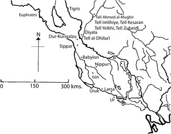
Map of southern Babylonia showing the main sites discussed in this text.

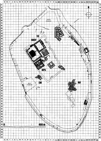
General plan of Ur in the Old Babylonian Period showing Woolley's site grid (after Woolley et al. 1976: pl. 116).

In the prompt preliminary publications (Antiquaries Journal 1923–34) of his excavations at Ur,Footnote 6 Sir Leonard Woolley identified housing structures which he dated to the Kassite and post-Kassite periods in areas EM, YC, XNCF, AH and KPS (Woolley Reference Woolley1965: 75–83; pls. 63A and B).Footnote 7 As the corpus of Kassite housing and associated graves is not great, it is important that the dating of the Ur structures is correctly determined. This paper seeks to do this by focusing on the excavated evidence from each of the housing areas and seeks to demonstrate, through a discussion of the stratigraphy and the recovered objects, that only the EM structures may be dated to the late second millennium b.c. The other remains (i.e. in YC, XNCF, AH and KPS) may best be dated to the 8th–7th centuries b.c. Aside from Woolley's discussion of the housing and a review in my unpublished doctoral thesis (Clayden Reference Clayden1989: 116–31), the only other study of the structures at Ur has been by Brinkman (Reference Brinkman1969: 331–32, 335) in a wider discussion of Kassite building activity at Ur.Footnote 8
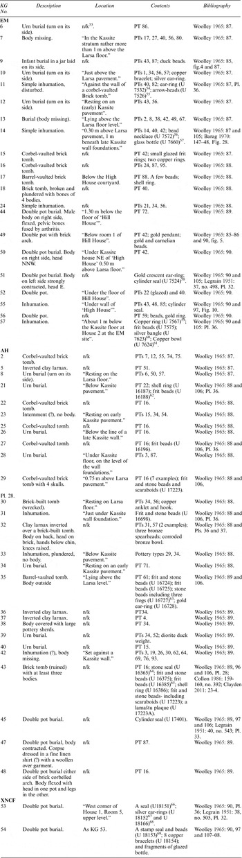
A catalogue of objects found in each area is presented, as well as a concordance of the Kassite period tablets found in area EM. A study of the graves identified as Kassite in areas EM, XNCF and AH is also presented (Appendix C), alongside an analysis of the datable objects.
Periods of prosperity at Ur between circa 2400 and 650 b.c.
An indicator of the prosperity and importance of a town in ancient Babylonia is the degree to which the ruler of the kingdom invested in building projects at the city. This information may be complemented by evidence from economic texts, but the discovery of these is even more open to the chances of archaeological excavation than are the ruins of buildings. In seeking to understand the excavated remains of a complex and multi-period site like Ur, it is necessary to have in mind the possible periods of greatest activity at the site, as the bulk of the excavated evidence is likely to come from these phases. Recognising the remains of intermediary periods is rarely straightforward.
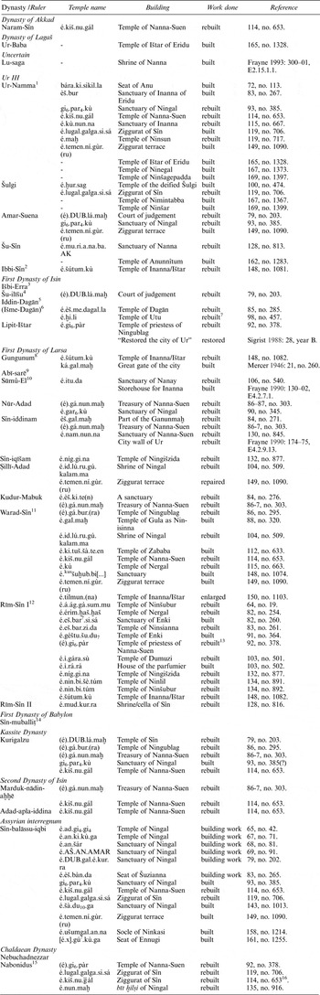
The general history of the city of Ur has been summarised most recently by Moorey (Reference Moorey1982) in his revision of Woolley's original text, and more briefly by Pollock (Reference Pollock and Meyers1997). Details of the royally sponsored building works on temples at Ur are summarised in Appendix A.
Excavations at the city have not reached the lowest levels of building in the religious temenos. However, three factors suggest that the temple buildings were founded at least by the Early Dynastic period. Ur was one of the cities in the Kiengi League, whose history “goes back deep into proto-literate times” (Westenholz Reference Westenholz, Sallaberger and Westenholz1999: 30, fn. 60). Ur also appears in the Sumerian Kinglist as one of the five cities to which kingship “descended” after the Flood (Frayne Reference Frayne2008: 6 and 377–78; George et al. Reference George2011: 202–5, nos. 98, 99) suggesting that it was an important city (Postgate Reference Postgate1992: 28–29) in the Early Dynastic I and later periods.Footnote 9 Excavations at Uruk have shown that the sequence of temples in the Eanna complex go back to the Ubaid period, and there is no reason to believe that the same did not happen at Ur (ibid. 24). Lastly, the earliest record of building at the Temple of Nanna-Suen at Ur states that it was being rebuilt (Appendix A, Narām-Sîn). The earliestFootnote 10 identifiable remains of the massive temple complex at the city may be dated to the Early Dynastic period when the Royal Tombs at Ur were also laid out (Woolley Reference Woolley1939: 1–23; Reference Woolley1955: 34–48; Moorey Reference Moorey1982: 51–121).Footnote 11 There was some construction work in the Akkadian period (Woolley Reference Woolley1955: 49–53; George Reference George1993: 114, no. 653).Footnote 12 Sargon had an especial affinity with the city, as he installed his daughter, Enheduanna,Footnote 13 as the entu-priestess of Nanna at Ur and who was insulted by the rebel leader of Ur, Lugalanne (Westenholz Reference Westenholz, Sallaberger and Westenholz1999: 54). In the subsequent three and a half centuries, and especially in the Ur III period, the city prospered.Footnote 14 It was in the reign of Ur-Namma that the most extensive building program of any period was conducted at Ur (Woolley Reference Woolley1939: 24–39, 98–121; Reference Woolley1974; Moorey Reference Moorey1982: 122–78; Appendix A: Ur III, Ur-Namma; see also Frayne Reference Frayne1997: 9–20 for a discussion of the events of his reign).Footnote 15 Ur-Namma rebuilt the ziggurat terrace (Woolley Reference Woolley1939: 98–121; George Reference George1993: 149, no. 1090).Footnote 16 The ziggurat was rebuilt by his successor, Šulgi (ibid. 119, no.706) who also conducted a number of other building projects at the city (Appendix A: Ur III, Šulgi);Footnote 17 as did Amar-Suena (Appendix A: Ur III, Amar-Suena)Footnote 18 and Šu-Sîn (Appendix A: Ur III, Šu-Sîn).Footnote 19 The corpus of over 3000 economic texts from the city dated to the reigns of the Ur III kings of Ur attest to the range and extent of commercial activity at the city (for the texts see Legrain Reference Legrain1947, Loding Reference Loding1976 and Black et al. Reference Black and Spada2008).Footnote 20
With the collapse of the Ur III kingdom at the end of the twentieth century b.c. through conquest by Elamites and Amorites and the sack of UrFootnote 21 the city went into decline (van de Mieroop Reference van de Mieroop1992: 45–69;Footnote 22 see also Brinkman Reference Brinkman1969: 311–14).Footnote 23 It changed hands several times during the periods of the kingdoms of Isin and Larsa, and was finally absorbed into the Kingdom of Babylon by Hammurabi when he conquered Larsa. Control of Ur was lost to Babylon during the Great Revolt in the reign of Samsu-iluna in the mid-late seventeenth century b.c. Footnote 24 Building works were conducted at Ur during the First Dynasties of Isin and larsa and most particularly under Warad-Sîn, son of Kudur-MabukFootnote 25 , who in the late eighteenth century b.c. was installed by his father as king at Larsa (Frayne Reference Frayne1990: 202). Warad-Sîn, the most energetic builder of the Larsa Dynasty (ibid.) conducted significant building and restoration work at Ur on the temples, city wall and surrounding canals (Woolley Reference Woolley1939: 40–47; Moorey Reference Moorey1982: 179–81; Appendix A: First Dynasty of Larsa, Warad-Sîn; see also Frayne Reference Frayne1990: 203–10, nos. 1–16; 212–16, nos. 9–10; 224–34, nos. 15–16; 236–43, nos. 19–21; 249–56, nos. 25–30).Footnote 26 A large area of a domestic quarter dating to the Old Babylonian period was excavated at Areas AH (Woolley et al. Reference Woolley, Mallowan and Mitchell1976: 118–66; Moorey Reference Moorey1982: 192–212) and EM (Woolley et al. Reference Woolley, Mallowan and Mitchell1976: 95–118). At least 1035 Old Babylonian economic texts were recovered at Ur (Figulla et al. Reference Figulla and Martin1953; Loding Reference Loding1976 and Reference Loding1976a; Spada Reference Spada2007) and attest to extensive economic activity at the city.Footnote 27 The numerous references to the city either topographically or in personal names in the Old Babylonian texts further attests to the importance of the city (see Groneberg Reference Groneberg1980: 247–49).
It was not until the early fourteenth century, some two and a half centuries after Samsu-iluna and four centuries after the previous phase in the reign of Warad-Sîn of large scale royally sponsored building works at Ur, that the city saw a renaissance. Kurigalzu I (x–1375 b.c.) was responsible for a programme of extensive building works throughout Babylonia (Brinkman Reference Brinkman1969: 315–19; Clayden Reference Clayden1996; Bartelmus Reference Bartelmus2010), including at Ur (Woolley Reference Woolley1939: 48–58; Moorey Reference Moorey1982: 216–23; Appendix A: Kassite period, Kurigalzu). There are no economic texts to complement the evidence for prosperity suggested by Kurigalzu I's works. The Kassite texts from Ur are from at least one archive dated to the thirteenth century b.c. (Gurney Reference Gurney1974 and Reference Gurney1983).Footnote 28
Between the reigns of Kurigalzu I and Sîn-balāssu-iqbi, the next significant “builder” at Ur, only two rulers built at the city—Marduk-nādin-aḫḫē (1099–1082 b.c.) and Adad-apla-iddina (1068–1047 b.c.; Brinkman Reference Brinkman1969: 335, Appendix A: Second Dynasty of Isin). The scant work at Ur is the only known royally sponsored work of Marduk-nādin-aḫḫē's turbulent eighteen-year reign (Frame Reference Frame1995: 38). Despite an Assyrian invasion Adad-apla-iddina built at Babylon(?), Isin, Kiš, Larsa Nippur and Ur (ibid. 50–51).Footnote 29 At Ur neither of these programmes of construction can be regarded as having been extensive, and they may represent refurbishments rather than core construction work or major rebuilding.
Under the Assyrian governorship of Sîn-balāssu-iqbiFootnote 30 in the first quarter of the seventh century b.c., over six hundred years after the reign of Kurigalzu I, a considerable amount of building work was undertaken at Ur (Brinkman Reference Brinkman1965: 248–53; Reference Brinkman1969: 336–42; Reference Brinkman2011: 514; Moorey Reference Moorey1982: 226–28; Frame Reference Frame1992: 125–26; Frame Reference Frame1995: 230–47, nos. 2001–16; Appendix A: Assyrian Interregnum). Sîn-balāssu-iqbi's extensive building activities appear to have been concentrated in the temple of Ningal and the Giparku. These works represent new structures which, though in some cases draw on earlier plans also include new buildings. Nebuchadnezzar II (604–562 B.C).began an ambitious programme of building at Ur, probably in the last years of his reign (Moorey Reference Moorey1982: 233), which was completed by Nabonidus (555–539 b.c.). Nabonidus, who famously favoured the cult of Sîn,Footnote 31 conducted the final Babylonian phase of recorded monumental building work (secular and religious) at Ur (Woolley Reference Woolley1939: 125–43; Woolley et al. Reference Woolley and Mallowan1962: 14–48; Brinkman Reference Brinkman1965: 255–57; Moorey Reference Moorey1982: 258; Appendix A: Chaldaean Dynasty). A small group of texts attest to economic activity at the city (Figulla Reference Figulla1949; Geller Reference Geller2006).Footnote 32 In inscriptions, clearly politically motivated, recording his conquest of Babylonia, the Persian king Cyrus refers disparagingly to Nabonidus' activities at Ur (Kuhrt Reference Kuhrt2007: I.70, no. E.a.21, line 5) and acknowledges the “help of Sîn in his (i.e. Cyrus') conquest” (ibid. I.75, 22.iii). Cyrus built part of the temenos wall and gates (Woolley et al. Reference Woolley and Mallowan1962: 2, 4–8). Thereafter a “deliberate and systematic” destruction of the ziggurat was conducted in the Achaemenid period (Woolley Reference Woolley1939: 144).
This review is not intended to be exhaustive, but it does provide indicative evidence for the periods for which we might expect building remains at Ur. In the second millennium b.c. these may be identified as Old Babylonian before the reign of Samsu-iluna; early fourteenth century b.c. during and after the reign of Kurigalzu I; the thirteenth century; and possibly the eleventh century b.c. For the first millennium b.c. the evidence suggests that widespread activity at the city did not begin until the seventh century b.c. It must be firmly noted that the breaks in known building activity, and/or evidence of economic activity from texts, should not be taken to mean that Ur was abandoned during such phases. Occupation continued at the town, but was probably on a smaller scale than at the peaks of prosperity for which we have some evidence.
Material dating evidence for the “Kassite Houses”
It is rare that poorly preserved and fragmentary building remains such as those represented by the “Kassite Houses” at Ur can be dated without reference to the objects found in them or to the graves found below, or cut into them. It is unfortunate that Woolley's excavation methods were unable to detect pits cut into lower levels. The result is that objects are sometimes assigned to an older level than that from which they originated. Against that background I now examine all those objects which were found in either context—i.e. in the houses (Appendix B) or in the graves (Appendix C).
Glass objects
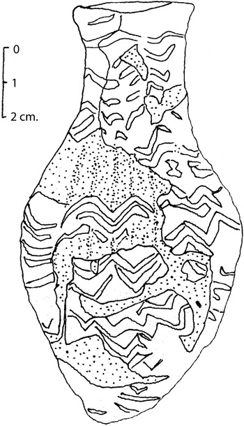
At least six glass objects were found in association with the “Kassite Houses”, of which four might be dated. A variegated glass bottle (Fig. 3) was found in KG 14 (Appendix C: EM, KG 14). It is a good example of vessels of the fifteenth to fourteenth centuries b.c. (Barag Reference Barag1985: 42). A second glass object, a glass rod (U 7593), which cannot be dated, was excavated in an un-stratified context above the EM house site (Appendix B: EM, No. 9). In area AH a glass bottle dated to the seventh century b.c. (Barag Reference Barag, Oppenheim, Brill, Barag and Von Saldern1970: 156 and 157, no. 2) was found below the floor and imbedded in the foundations of a house (Appendix B: AH, No. 2) whose construction it must pre-date. A second glass bottle, also dated to the seventh century b.c. was found in the ruins above the AH houses (Appendix B: AH, No. 3).
The glass bottle (cf. Table II. EM KG 14; Appendix C, EM KG 14) with blue zigzags on a yellow/fawn background excavated in the EM house area. The stippled area indicates the reconstructed portions of the bottle (drawing author's own).

Texts
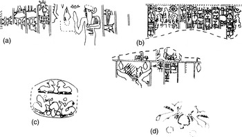
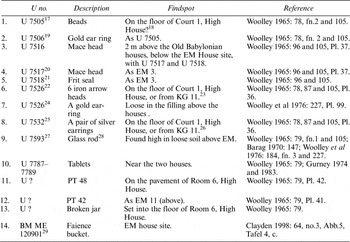
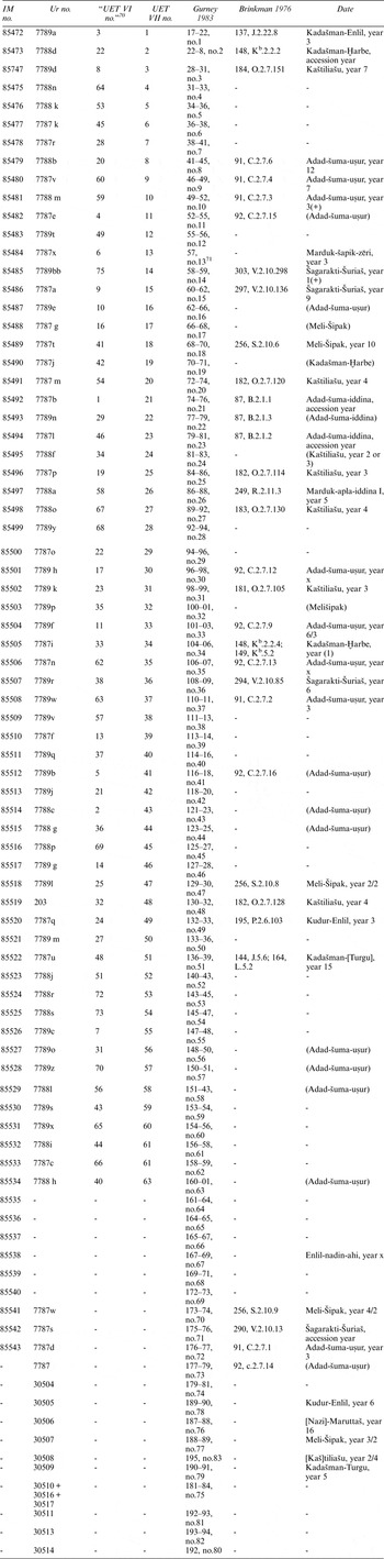
Woolley dated the remains of the EM House site on the basis of seventy-one tablets from the archive of the Dayyānātu family and other brewers, bearing dates and in some cases seal impressions (Fig. 4),Footnote 33 between the reigns of Nazi-Maruttaš (1307–1282 b.c.) and Marduk-apla-iddina I (1171–1159 b.c.) and a single text (possibly an interloper, dated to Marduk-šāpik-zēri (1081–1069 b.c.) (Gurney Reference Gurney1983: 13-4; Appendix B: EM, No. 10). Gurney (Reference Gurney1983: 1) discussed the provenance of the tablets noting the ambiguities of the published and unpublished evidence.Footnote 34 The overall result is that we must conclude that the precise provenance of the tablets is unclear beyond that they were found loose in the soil in the vicinity of the building remains of High and Hill houses and above the underlying Old Babylonian remains. Burrows (Reference Burrows1927: 404), who was a member of the excavation team for the fifth season of work, during which the tablets were found, states that they were found in the “upper stratum of the residential quarter, above Quiet Street”. He notes (ibid.) that in the same stratum were found a variety of other texts including Sumero-Akkadian syllabaries and Sumerian hymns. The mix of objects from various periods in the same stratum strongly suggests that the stratigraphy was badly disturbed in this area and that the soil in which these various tablets were found was secondary dump material.
The sealings on the EM House tablets (cf. Appendix B: EM.10): (a) Kadašman-Enlil (Gurney 1974: pl. 79.1); (b) Adad-šuma-uṡur (ibid.: pl. 79.9); (c) Marduk-apla-iddina (ibid.: pl.79.26) and (d) Adad-šuma-uṡur (ibid.: pl. 79.69).

The Ur excavation record cards for the tablets read as follows:
U 7787: Tablets. 20 business documents principally contracts (including 4 covered with seal impressions, which are unmarked in a boxFootnote 35 ): dated to latter part of Kassite dyn[asty] (13 cent[ury]): cf. a. dŠa-gar-rak-ti-Šu-ri-ia-aš 1262-50; b. d Rammān-šum-iddin(SUM)-ma (mu-sag) 1238-33; c. d Rammān-šum-nāṣir 1232-03; d. DittoFootnote 36 . Therefore dates of Q[uiet] S[treet] High level = 1262-1175. Quiet St. High level.
U 7788: Tablets. Contract tablet. A. Dated to Marduk-apal-iddina I 1187-74; B. [dated to] Rammān-šum-iddina 1288-33. Probably Quiet St. High level”.
U 7789: Tablets. Small tablets and fragments (24 more or less complete small tablets: most, probably all, business: 7 considerable, + 5 small fragments, prob[ably] partly belonging together, but not joinable. 4 small fragments (unnumbered in match box Footnote 37 ). One tablet apparently dated to Kadasman-Enlil (II ? 1276-71). Quiet Street High level.
A number of late third millennium b.c. and early second millennium b.c. tablets, cones and bricks were found in the course of the excavation of the building remains in the KPS House site (Appendix B: KPS, Nos. 1–2, 4–6, 8–16, 74). The context of each is either vague or in what would appear to have been secondary fill. These objects do not date the structures. However, one tablet (Appendix B: KPS, No. 3) is dated to the reign of Nergal-ušēzibFootnote 38 (693 b.c.) and was found below the upper floor level of Room B.4.
Tablets dated to the neo-Babylonian period were found in either Room 5 or 9 in the XNCF House site (Appendix B: XNCF, No. 1).
Incense burner
A clay incense burner was found in Room 7 or 8 of the YC house remains (Appendix B: YC, No. 1). These objects are to be dated to the neo-Babylonian and Persian Periods (O'Dwyer-Shea Reference O'Dwyer Shea1983: 82–83, Ur (8), 99; Millard Reference Millard1984: 172)—that is the seventh century b.c. or later.
Faience bucket
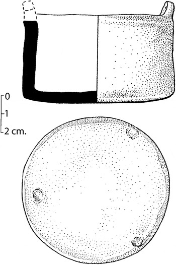
A faience bucket (Fig. 5) was found in the excavations of the EM house site, but no precise provenance was recorded (Clayden Reference Clayden1998: 64, no. II.3). This type of object is a “type artefact of the late Kassite Period” c. 1350–1150 b.c. (ibid. 47).Footnote 39
The faience bucket (cf. Appendix B: EM.14) excavated in the EM house area (after Clayden1998: Taf. 4,c).

Lamaštu plaque
A lamaštu plaque was found in a grave in the AH area (Appendix C: AH, KG 43). I have discussed separately the dating of lamaštu plaques (2011: 23–24), and reject (ibid.) the Kassite dating of the Ur plaque as the earliest occurrence of this form of object. All other provenanced examples date to the first millennium b.c., and more specifically to the neo-Babylonian period (see also Becker Reference Becker and Boehmer1993: 4–5), to which we should date this plaque.
ScaraboidsFootnote 40
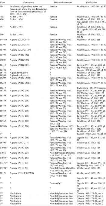
Scaraboids were found in two graves in the AH area (Appendix C: AH, KG 29, 43). They were not illustrated in the publication. KG 43 is dated to the first millennium b.c. by the lamaštu plaque in the grave assemblage, and KG 29 by the seven PT 16 vessels (see below) in the grave and a single example in KG 43. At least forty further scaraboids were found at Ur in graves dated to the Persian period (see Table 1 below) and a further five whose provenance is unknown, but whose styles date them to the neo-Babylonian period (Table 1). At Babylon a scaraboid was found in a neo-Babylonian grave, which also contained a lamaštu plaque (Reuther Reference Reuther1926: 199, no. 730). Woolley et al. (Reference Woolley and Mallowan1962: 103) notes that some scaraboids were found in neo-Babylonian graves, but that the use of scaraboids rather than cylinder seals is characteristic of the Persian period. Giveon (Reference Giveon1985: 170–71) catalogues five scaraboids from Ur (precise provenance unspecified), all dated to the “Late Period” (i.e. first millennium b.c.).
Scaraboids found at Ur.Footnote 50

Scaraboids “are found all over the [ancient] Near East in and after the seventh century b.c.” (Porada Reference Porada1958: 71). They have been excavated in seventh century b.c. contexts in Urartu (Barnet et al. 1952; van Loon Reference van Loon1977: 229); Nineveh in the form of impressions on bullae, dockets or tablets (Mitchell et al. 2007: 10);Footnote 41 Nimrud;Footnote 42 Assur (Jakob-Rost Reference Kakob-Rost1997: 64–103);Footnote 43 Babylon (idem)Footnote 44 and Kish.Footnote 45 The appearance of these objects in Babylonia in the neo-Babylonian period is not surprising given the contact (albeit hostile) between Nebuchadnezzar II and Egypt (see Kuhrt Reference Kuhrt1995: II, 590–97). It is likely that Egyptians, either as prisoners of war or as merchants living where they wished, were present in Babylonia during the neo-Babylonian period (Wiseman Reference Wiseman1966).
However, it should be noted that scaraboids were found in three other graves from Merkes at Babylon which would appear to date to the late Kassite or Isin II period (Reuther Reference Reuther1926: 166, Erdgrab 13, Tafel 47, 13 e;Footnote 46 168, Erdgrab 15, Taf. 47, 15 23 and 24;Footnote 47 169, Erdgrab 16, Taf. 48, 16 13). A scaraboid was found at Tell Yelkhi in a tomb dated by the excavators to the fifteenth century (Quarentelli Reference Quarantelli1985: 381 and 387).Footnote 48 What may be a genuine Egyptian scarab bearing the throne name of Sety I (r. 1314–1304 b.c.) was found at Uruk (Boehmer Reference Boehmer1991a: 145, no. 40).Footnote 49
Three scaraboids have also been found in a disturbed context next to the ziggurat at Dūr-Kurigalzu (Malko: Reference Malko, Bartelmus, Roaf and SternitzkeForthcoming). Their dating is unclear, but the form and material of the scaraboids suggests a neo-Babylonian/Persian date.
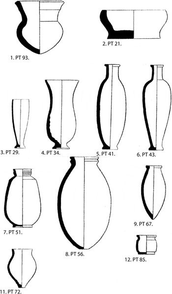
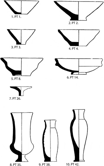
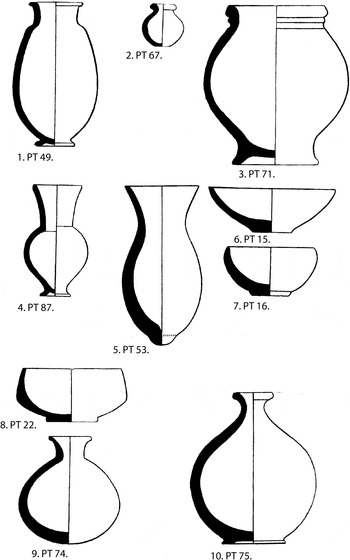
The pottery(Plates I – III)Footnote 64
In his publications of the excavated pottery from Ur, Woolley devised a system of “pottery types” (PT) for each of the various periods at the site. In his discussion of the Kassite pottery (Woolley Reference Woolley1965: 97–8, Plates 38–46) Woolley (ibid. 97) noted that the “Kassite pottery” was “so far from distinctive that for dating purposes its evidential value is small”. He dated 100 vessel forms to the Kassite or later periods on the basis of archaeological stratification (ibid.), though noted that the identifications as Kassite for at least 20 per centFootnote 65 were “doubtful”. More often pottery is used to date the contexts in which it is found, but at the time of Woolley's excavation and subsequent publications there were no pottery comporanda which he could use to date the vessels from Ur.
Plate I

Plate II

Plate III

In his publications Woolley illustrated his discussions of pottery with stylised drawings of each pottery type, with similarly schematic profiles and no description of the fabric. Woolley's discussions of pottery are so abbreviated that they do not assist in evaluating the date of the pottery types. The original record cards from the excavations are equally un-informative. Further, although individual pots were retained and some returned to the collections of the British Museum and the University Museum in Philadelphia, the specific provenances of few are recorded. In short the Ur pottery, both published and unpublished, is a particularly problematic tool when seeking to date a particular context.
The most recent study of Kassite pottery is by Armstrong (Reference Armstrong1989: 31–38 and 40–41),Footnote 66 who drew mainly on material excavated at Tell ed-Dēr (ibid. 15–16), Tell ed-Deylam (ibid. 16) and Nippur (ibid. 16–17). Other substantive studies of Kassite pottery include those by Armstrong (Reference Armstrong and Gibson1981a: 153–56; Reference Armstrong1989: 57–61, 306–11; Reference Armstrong and Zettler1993), Ayoub (Reference Ayoub and Hrouda1982), Boehmer (Reference Boehmer, Boehmer and Dämmer1985: 12–18; Reference Boehmer, Boehmer and Dämmer1985a: 46–54), and Clayden (Reference Clayden1989: 213–22).Footnote 67
On the pottery from Ur, Armstrong (Reference Armstrong1989: 4) commented that it “has not proved useful in developing a ceramic corpus because stratigraphic control was inadequate and record-keeping was poor. Although post-Kassite/pre-Neo-Babylonian levels were uncovered in both domestic and public areas of the city, and much pottery was illustrated in the final report, the ceramics from those levels cannot be reliably identified, because the information in the publication is insufficient”.
Of the fifty-four PTs found in or in association with the “Kassite” houses at Ur,Footnote 68 only two PTs were not found in graves—PT 42 (Appendix B, EM 12) and 48 (Appendix B, EM 11). PT 48 was not found in any of the graves, while examples of PT 42 were.
Taking into account the weakness of the data and by comparing the stylised illustrations published by Woolley (Reference Woolley1965: pl. 38–46) to material excavated elsewhere, we are able to venture a tentative dating for only thirty six of the fifty four PTs,Footnote 69 and of these only fifteen relating to the Kassite period.Footnote 70 For all, the dating may be made either on the basis of the vessel form, or by datable objects associated with the pottery vessel—especially true in the case of grave goods.
Akkadian/Ur III.
PT 93 (ht. c. 11.25 cm, Plate I.1): The drawing is too poor to be more finely dated, but the form is diagnostic of the Akkadian/Ur III period (see Ayoub Reference Ayoub and Hrouda1982: 53, type 49). It was found in KGs 33 and 39, which may also have had Old Babylonian pottery in them (see below).
Old Babylonian
PT 21 (ht. c. 4.8 cm, Plate I.2): An example of this type was found in EM KG 24 along with two other vessels which may be dated to the Old Babylonian period—PTs 34 and 56 (themselves dated by association with OB pottery types—see discussion below).
PT 29 (ht. c. 16.4 cm, Plate I.3): An example of this PT was found in KG 33 along with PT 34, which is probably Old Babylonian in date. This suggests that PT 29 should be similarly dated.
PT 34 (ht, c. 23.6 cm, Plate I.4): The form suggests that it is Old Babylonian in date (Gasche et al. Reference Gasche, Armstrong, Cole and Gurzadyan1998: pl. 1 no. 12). This suggests that PTs found with it should be similarly dated: 1, 56, 57 (KG 10); 15, 54 (KG 23); 56 (KG 30); 29 (KG 33); 52 (KG 39). PT 57 is probably to be dated to the Old Babylonian period (see below). This may provide dating for all the other PTs found in the various graves. However, PT 15 has a form which is possibly neo-Babylonian in date (see below), which suggests that the drawing and therefore dating of one or both is suspect.
PT 40 (ht. c. 22.25 cm, Plate I.5): Ur III/Old Babylonian (see Ayoub Reference Ayoub and Hrouda1982: 46, type 9b).
PT 43 (ht. c. 18 cm, Plate I.6): Ur III/Old Babylonian (ibid.).
PT 51 (ht. c. 25 cm, Plate I.7): Isin/Larsa – Old Babylonian (ibid. 46–47, type 13).
PT 56 (ht. c. 39 cm, Plate I.8): See the discussion for PT 34 above.
PT 57 (ht. c. 22.5 cm, Plate I.9): The form is poorly represented, but may be Old Babylonian in date (ibid. 53–54, type 51)Footnote 71 .
PT 72 (ht. c. 15.5 cm, Plate I.11): Old Babylonian (ibid. 51, type 40)Footnote 72 .
PT 85 (ht. c. 8.5 cm, Plate I.12): Early Old Babylonian (ibid. 50, type 34).
Kassite. PTs 1–3
(Plate II.1–3): Straight sided shallow bowls (heights between c. 4.5 and 6.25 cm) with a simple rim and shallow concavity with rim diameters of between 12 and 14 cm are features of a Kassite pottery type at Babylon (Reuther Reference Reuther1926: pl. 58, nos. 49a and c); Tell ed-Dēr (Minsaer Reference Minsaer1991: pl. 7, nos. 1-5; pl. 9, nos. 1–40), Tell Imlihiyeh (Boehmer Reference Boehmer, Boehmer and Dämmer1985: pl. 28, nos. 20, 23–28, 32), Larsa (Parrot Reference Parrot1968: fig. 14, no. 17 and L.449), Nippur (Armstrong Reference Armstrong1989: 58, type 1; 306, fig. 61) and Tell Zubeidi (Boehmer Reference Boehmer, Boehmer and Dämmer1985a: pl. 114, nos. 138–39, 142 and 145). However, relatively crude shallow and straight-sided bowls appear in almost every period. These PTs may only be dated to the Kassite period if they are associated with remains or objects which are clearly Kassite in date (e.g. in the case of the pottery assemblage in KG 13, see below). The description (written and diagram) of the vessels is so imprecise that they could be from various periods.
PT 4 (ht. c. 4.4 cm, Plate II.4): Open bowls with a carination mid-way down the body of the vessel are found at Tell ed-Dēr (Minsaer Reference Minsaer1991: pl. 7, nos. 10–11, 13) and Tell Yelkhi (Valtz Reference Valtz2002–2003: 281, fig. 142, nos. 10–11).
PT 8 (ht. c. 4.8 cm, Plate II.5): See the discussion of PT 38. The form could also resemble one of Armstrong's Type 1 vessels (ibid.). Examples may also be identified from excavations at and Tell ed-Dēr (Minsaer Reference Minsaer1991: Pl. 7, nos. 12-15); Larsa (Parrot Reference Parrot1968: 221, fig. 14 mid right hand side); Tell Yelkhi (Valtz Reference Valtz2002–2003: 281, nos. 21–23) and Tell Zubeidi (Boehmer Reference Boehmer, Boehmer and Dämmer1985a: pl. 115, nos. 160–61, 164, 168–69, 171 and 174–75). Again the drawing is so imprecise that we cannot be certain.
PT 14 (ht. c. 5.5 cm, Plate II.6): An example of this PT was found in EM KG 14 along with Kassite PT 42 and Old Babylonian PT 40. The date of PT 42 is very clear. In addition the grave is also dated to the Kassite period by a glass bottle (U 7660) found in it. This suggests that the grave is Kassite in date, and that while the dating of the general form PT 40 is certain, the actual vessel in the grave was not an example of PT 40. Examples of these vessels may have been found at Tell ed-Dēr (Minsaer Reference Minsaer1991: 7–8), Dūr-Kurigalzu (Baqir Reference Baqir1945: pl. XXIII, Palace Levels I, II and IV); Tell Imlihiyeh (Boehmer Reference Boehmer, Boehmer and Dämmer1985: Taf. 31, nos. 66–69) and Tell Yelkhi (Valtz Reference Valtz2002–2003: 281, fig. 142, nos. 31–32). PT 14 is not one of the forms noted as Kassite by Armstrong (Reference Armstrong1989: 57–61).
PT 26 (ht. c. 6.5 cm, Plate II.7): This would appear to be a lid, similar examples of which have been found at Tell ed-Dēr (Minsaer Reference Minsaer1991: pl. 19, nos. 9–11), Dūr-Kurigalzu (Baqir Reference Baqir1945: pl. XXIII, Palace Level IV) and Tell Zubeidi (Boehmer Reference Boehmer, Boehmer and Dämmer1985a: Taf. 133, nos. 462–68).
PT 35 (ht. c. 13.8 cm, Plate II.8): Button based cups with flaring rims are characteristic of the Kassite pottery assemblage at Nippur (Armstrong Reference Armstrong1989: 58, 60, type 5; 308, fig. 63, nos. 9–13). Examples have been found at Dūr-Kurigalzu (Baqir Reference Baqir1945: pl. XXIII, Level IV) and Tell Yelkhi (Valtz Reference Valtz2002–2003: 297, fig. 151, no. 1).
PT 38 (ht. c. 22 cm, Plate II.9): An example of this PT was found in EM KG 13 along with Kassite PTs 2, 8 and 42 (the clearest Kassite form in the Ur assemblage as published). This confirms the dating as Kassite of PTs 2 and 8, and suggests that PT 38 is also Kassite in date. An example of the form was found at Tell Zubeidi (Boehmer Reference Boehmer, Boehmer and Dämmer1985a: Taf. 132, no. 457). However, the form does not appear to be represented at Tell ed-Dēr, Dūr-Kurigalzu or Nippur.
PT 42 (ht. c. 18 cm, Plate II.10): This PT is virtually the type fossil for the middle Kassite period (14th–13th centuries b.c.). Examples of these vessels have been found on all sites at which Kassite occupation has been found (for a description of the form see Armstrong Reference Armstrong1989: 60, type 6; 309, fig. 64; and Gasche et al. Reference Gasche, Armstrong, Cole and Gurzadyan1998: pl. I for a discussion of the evolution of the form; for photographs of examples from Ur see Rigillo Reference Rigillo1999: 201–2, nos. 51–52).
PT 49 (ht. c. 32 cm, Plate III.1): An example of this PT was found in EM KG 13. For the Kassite dating of the PT see the discussion for PT 38.
PT 67 (ht. c. 9 cm, Plate III.2): An example of this PT was found in EM KG 13. For the Kassite dating of the PT see the discussion for PT 38. Similar vessels were found in burials of the late, or immediately post- Kassite period, at Tell Imlihiyeh (Boehmer Reference Boehmer, Boehmer and Dämmer1985: Taf. 53, nos. 277–79) and Tell Zubeidi (Boehmer Reference Boehmer, Boehmer and Dämmer1985a: Taf. 132, nos. 436–40). The Ur example was also found in a grave (Appendix C: KG 13).
PT 71 (ht. c. 70 cm, Plate III.3): Large urns of this form appear to have been used in burials as containers for the corpse (e.g.Tell ed-Dēr, Gasche Reference Gasche1991: 27, fig. 7, Tombe 368). The Ur examples may have served the same function.
PT 87 (ht. c. 12.25 cm, Plate III.4): Probably an open variant of PT 35. Examples of the form (for the evolution of which see Gasche et al 1987: pl. 3) may have been found at Tell ed-Dēr (Minsaer Reference Minsaer1991: pl. 12, nos. 1–3), Dūr-Kurigalzu (Baqir Reference Baqir1945: pl. XXIII, Palace Levels II and III), Tell al-Mughir (Armstrong Reference Armstrong and Gibson1981a: pl. 114, no. 40) and Tell Ajamat (ibid. pl. 116, nos. 8–9).
Isin II. PT 53
(ht. c. 14.2 cm, Plate III.5): Nipple-based cups similar to this PT were found in the late- or immediately post-Kassite contexts at Imlihiyeh (Boehmer Reference Boehmer, Boehmer and Dämmer1985: Taf. 51, nos. 249–50); Isin (Hrouda Reference Hrouda and Hrouda1981: 87, no. 30); Uruk (Hrouda 1988: Taf. 16, no. 31) and Zubeidi (Hrouda 1985a: Taf. 132, nos. 433–34). A single example was recorded in a post-Kassite context at Nippur (see Armstrong Reference Armstrong1989: 195–96 for the post-Kassite dating).
Eighth/seventh centuries b.c
PT 15 (ht. c. 4.7 cm, Plate III.6): Probably dated to the neo-Babylonian period. Examples of what may be this PT were found at Nippur (Armstrong Reference Armstrong1989: 66, type 15; 313, fig. 68).
PT 16 (ht. c. 5.25 cm, Plate III.7): An example of this PT was found in AH KG 43 along with a lamaštu plaque dated to the “First millennium b.c.” The scaraboids in the grave must be similarly dated. PT16 is not found in association with any other PT. Examples of what may be this PT were found at Nippur (ibid. 66, type 15; 313, fig. 68, no. 2).
PTs 22 (ht. c. 5.75 cm, Plate III.8), 74 (ht. c. 9.6 cm, Plate III.9) and 75 (ht. c. 17 cm, Plate III.10): The forms suggest that they should be dated to the eighth/seventh centuries b.c.
PT 80: This PT resembles neo-Babylonian vessels found at Nippur (Armstrong Reference Armstrong1989: 69–70, type 34; 320, fig. 75, nos. 5–7).
The graves in the “Kassite” housing areas
Woolley identified fifty graves dated to the Kassite or later period (1965: 84–90).Footnote 73 The majority of these were from the EM (twenty-one graves) or AH (twenty-seven graves) house areas; with two found in XNCF (Appendix C). These graves are part of a small corpus of excavated burials identified as Kassite at a number of sites:Footnote 74 Babylon (Reuther Reference Reuther1926: 158–94), Tell ed-Dēr (Baqir et al. Reference Baqir and Mustafa1945: 50–52, nos. 2, 10–11, 13–14, pl. I; Gasche Reference Gasche1991: 25–29), Tell al Dhiba'i region (Mustafa Reference Mustafa1949: 174), Dilbat (Armstrong Reference Armstrong1992: 221–22), Tell Imlihiye (Boehmer et al: Reference Boehmer, Boehmer and Dämmer1985: 5–8), Isin (Karstens Reference Karstens and Hrouda1981), Tell es-Sawwan (al-Soof Reference al-Soof1968: 6),Footnote 75 Tell Kesaran (Fiorina Reference Fiorina2007: 10–17), Tell Laham (Safar Reference Safar1949: 161–63), Nippur (Area WC, Zettler Reference Zettler1993: 39; Area TA, McCown Reference McCown, McCown, Haines and Hansen1967; Reference McCown, McCown, Haines and Hansen1967a: 147), Tulul Khattab (Isma'el Reference Isma'el2007: 6), Uruk (Boehmer Reference Boehmer1987: 67–68 and 89–91; Boehmer Reference Boehmer, Boehmer, Pedde and Salje1995), Tell Yelkhi Levels I and II (the palace), (Fiorina Reference Fiorina2007: 17–30), and Tell Zubeidi (Boehmer et al. Reference Boehmer, Boehmer and Dämmer1985a: 35–45).Footnote 76 Given the small size of the corpus, it is important to establish whether or not any of the “Kassite Graves” at Ur from the housing areas are in fact really Kassite in date.Footnote 77
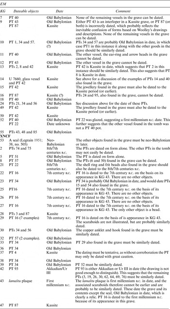
Using the problematic pottery dating noted above and the dateable objects found in the tombs, an attempt to date the graves from EM, XNCF and AH housing areas may be made, and is summarised in Table 2. Only those graves containing an object or vessel type that can be dated is included.
Dateable objects in the graves associated with the “Kassite houses” in areas EM, XNCF and AH.

The “Kassite Houses”
Against the background of the historical evidence and of the dateable objects found in the houses and in associated graves we may now turn to the archaeological remains.
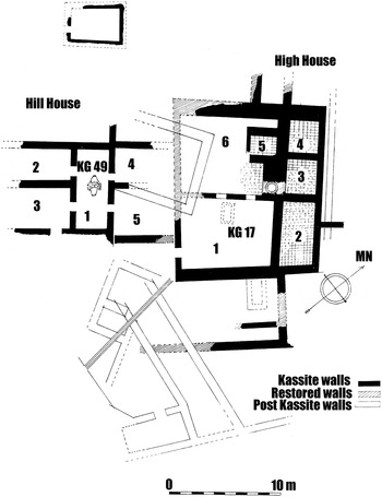
The EM site (Fig. 6)
The EM House site lay in S-V/44-46 (Figs. 6 and 9) and was excavated in the fourth season of work at the site (Woolley Reference Woolley1927: 386–404, see 386–87 for the Kassite remains). Final publication of the excavations was divided between the Old Babylonian and Kassite volumes of the Ur Excavations series (Woolley Reference Woolley1965: 78–79, pl. 63A; Woolley et al. Reference Woolley, Mallowan and Mitchell1976: 95–117). The only published plan for the area in the post Old Babylonian period (Woolley Reference Woolley1965: pl. 63A) is not shown in relation to the larger site plan, but the remains are said to be “high on a slope facing west” (ibid. 78). By far the most interesting aspect of the area was the extensive and well preserved remains of Old Babylonian housing that lay beneath the badly eroded remains of the Kassite to neo-Babylonian periods.
The EM building remains (after Woolley 1965: pl. 63A).

The excavations in EM revealed essentially three levels of remains which Woolley dated to the early second millennium b.c.; late second millennium b.c.; and mid-first millennium b.c. The earliest levels, early second millennium b.c., were well preserved and extensively excavated (Woolley et al. Reference Woolley, Mallowan and Mitchell1976: 95–118). These remains Woolley dated to the Old Babylonian/Kingdom of Larsa period (ibid. 15). He did so firstly on the basis of tablets found in association with the ruins, and secondly by relating the sack of Ur by Samsu-iluna in his year 11 with the destruction level seen in the area—noting that “most of the houses also bore marks of fire, the mud brick of the upper part of the walls being burnt to a deep red and their pavements covered in charred wood” (ibid. 13). The area was heavily populated. The houses as published were not all contemporary with one another; nonetheless, they provide a good indication of the layout of the house interiors and street design (ibid. pl. 122). It would appear that the houses were not rebuilt and the area may simply have been abandoned. KG 14 is described as being situated “0.30 m above the Larsa (i.e. early second millennium b.c.) pavements, 1 m beneath the late Kassite wall foundations” (Woolley Reference Woolley1965: 87). This provides a very rough approximation of the extent of deposition between the early and later second millennium b.c. levels. Other “Kassite Graves” and structures were recorded as having cut into the early second millennium b.c. levels (cf. Woolley Reference Woolley and Mallowan1962: 52, 64; Reference Woolley1965: 87, 90; Reference Woolley, Mallowan and Mitchell1976: 106, 111, 116–17).
The upper levels containing the late second millennium and mid-first millennium b.c. structures were poorly preserved. In describing the remains, Woolley noted that “those of the Kassite Period were so ruinous and fragmentary that no consistent plan of them could be made and deductions based on them would have been of little value” (Woolley et al: Reference Woolley, Mallowan and Mitchell1976: 14). In his more detailed discussion of the remains Woolley (Reference Woolley1965: 78–79) defined two structures which he identified as Hill House and High House. Hill House was built on the slope of the hill, and “some of its walls had been retaining walls of the terraces into which the slope was cut” (ibid. 78). The walls, 0.60 m thick, were built of baked brick and in places preserved up to 18 courses high with 5 below floor level—i.e. the foundations. The floors were simple mud, except in Room 2, where remains of a later brick pavement survived. The walls were not all contemporary, but did represent a coherent floor plan which appears to have been renewed. There no finds from this building, but KG 49, dated to the Kassite period (see above), was situated below the central court.
High House adjoined Hill House to the north-east. The walls had a facing of burnt brick with a mud and rubble core and in places are preserved up to 13 courses high. The floors of the house are a mix of mud or brick (Rooms 2 and 3). Room 6 is at a higher level than the court and shows how the property was terraced into the slope of the hill. On the floor of Room 6 were two pottery vessels (Appendix B: EM Nos. 11–12) and a broken jar set into the floor (Appendix B: EM No. 13).
To the south-east of High House was a separate room which was very poorly preserved having been cut by later walls and a conduit. No objects were found in this room, and only a plundered vault tomb lay below it.
Twenty-one graves were excavated in the EM Area (Appendix C: EM). Of these, fifteen contained objects (including pottery) which may tentatively be dated (see discussion above). Of these fifteen graves, eight contain PTs which should probably be dated to the Old Babylonian period (KGs 7, 9–12, 18, 24, 55). One was located below High House (KG 55); two are identified as lying above “Larsa” floors (KGs 7, 9 and 13); and the remaining five were either disturbed or have no context (KGs 9, 11, 18, 24).
Six of the fifteen graves with dateable objects may be dated to the Kassite period (Appendix C: EM KGs 13–16, 49–50). Two (Appendix C: EM KGs 15 and 16) have no context; one (Appendix C: EM KG 13) was found above a “Larsa” floor; one (Appendix C: EM KG 14) was found below the “late Kassite wall foundations”; and two (Appendix C: EM KGs 49 and 50) were found below Hill or High Houses. The last two graves suggest a Kassite date for Hill House and High House.
Two other objects date High House roughly to the Kassite Period—the glass bottle in KG 14 below High House, and PT 42 found on the pavement of High House Room 6 (Appendix B: EM nos. 11 and 12).
The Kassite period tablets found in the EM House area date to the thirteenth–eleventh centuries b.c. They were not found in direct association with the house remains and appear to have been in secondary contexts, probably later fill. This may suggest that the tablets post-date the houses as they were in fill associated with the houses. However, it is also possible that the tablets were redeposited from an earlier level when soil was displaced from elsewhere. In conclusion, the dating, at least for High House, appears to be firmly Kassite, and therefore the best judgement that can be made is that the archaeology of the area was so disturbed that it is not possible to link the tablets and the housing remains. The tablets may instead provide further confirmation that there was Kassite period housing in the area.
The faience bucket found in the EM house site and dated to the late Kassite Period, though unprovenanced, provides further evidence of activity in the area at this time.
In conclusion, it is apparent that Hill and High Houses may be dated to the Kassite period, and possibly more specifically to the thirteenth century b.c.
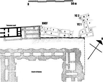
The YC area (Fig.7)
The YC remains lie in 29/T on the site grid (Woolley Reference Woolley1965: 75–76, pl. 56). The remains were not extensively excavated and they were poorly preserved. Woolley (ibid. 75) opened his publication of the structures by stating that they were “not of any particular importance”. He defined two structures—YC1 consisting of rooms 1–9 (ibid. 75–76); and YC2 consisting of rooms 10-12 (ibid. 76). YC1 was the earlier of the two and had wall foundations nine baked bricks deep. Area 2 was probably a courtyard and at a later phase contained a furnace. Area 2 was probably paved with baked brick, but the other rooms in the structure had mud floors. The walls showed signs of successive levels of plastering, suggesting continuous use over a period, but not excessively long. Two drains run from the house to the south-west. YC2 was added to YC1 against which it abuts, but they show no sign of internal communication between the two. The floors are of mud.
The stratigraphy of YC1 and YC2 is interesting (cf. ibid. 75). The structures overlie the temenos wall refurbished by Kurigalzu I in the first quarter of the fourteenth century b.c. and are beneath the temenos wall built by Nebuchadnezzar II in the late seventh or early sixth century b.c. The YC structures must therefore date to some point after the Kurigalzu temenos walls had crumbled and their importance had been lost; and before the reign of Nebuchadnezzar. It is not possible to date when the Kurigalzu walls would have fallen into disuse, but a post-Kassite date is likely. In addition the north-east end of the structures was cut away and a “solid rampart of mud and brick” (ibid. 76) c. 2 m high ran over them. Woolley (ibid.) argued that this rampart should be associated with the rough defences erected in the reign of Nabonidus (559–539 b.c.) to defend against a Persian attack.
A more precise date for the structures may be provided by the seventh century b.c. or later clay incense burner found in either Room 7 or 8 (Appendix B: YC, No.1). Given that the structures lay below the Nebuchadnezzar wall a seventh century date for this incense burner would appear to be correct. The houses in YC1 and YC2, which do not show signs of having a long series of rebuilding phases, may, therefore, best be dated roughly to the eighth to seventh centuries b.c.
The XNCF area (Fig. 7)
The XNCF area (21/T-U) was excavated in the tenth season of excavations (Woolley Reference Woolley1932: 388–89, pl. LXXV; Reference Woolley1965: 76–77, pl. 56). The excavations, the objective of which was to expose the temple temenos wall, were not extensive and the remains were not fully revealed (Woolley Reference Woolley1932: 389). The remains show that the building consisted of at least ten rooms, with mud and brick paved floors.
The YC and XNCF House sites (after Woolley 1965: pl. 56).

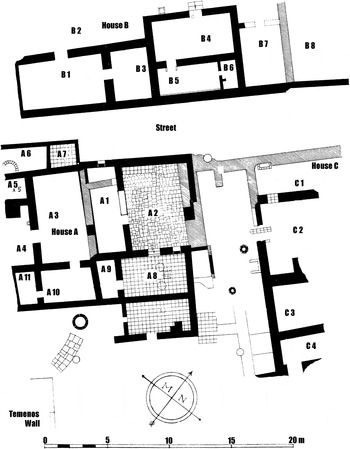
The KPS house site (after Woolley 1965: pl. 63B).

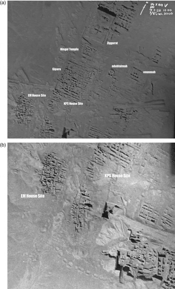
(a) Aerial photograph of Ur taken by the RAF at 11am on 9th March 1932; (b) detail. The Old Babylonian remains in the EM house site and the 10th–7th centuries b.c. houses in the KPS area may be seen (Published by courtesy of University College London, Institute of ArchaeologyFootnote i ).

There are indications of several repairs and alterations having been made to the structure, but overall there appear to have been two main phases of construction. It is not clear which is shown on Woolley's plan (1965: pl. 56, here Fig. 4). The levels of the floors vary by as much as a metre (e.g. Rooms 9 and 10, with 10 being nearly 1 m higher than 9).
The stratigraphic evidence for the dating of the XNCF house is that it overlay the ruined temenos wall, and was itself overlaid by neo-Babylonian housing (ibid. 77). Two graves, KG 53 and 54 (ibid. 90) were cut into the XNCF remains. KG 53 contains a neo-Babylonian seal (see above). The crucial dating evidence for the XNCF house was found in Room 5 or 9.Footnote 78 Here a rectangular basin (0.95 × 0.75 m) with signs of burning was set into the mud-brick floor. Near the basin were found tablets (Appendix B: XNCF, No. 1) dated to the neo-Babylonian period. Also very important in this context is the variegated glass bottle dated to the eighth/seventh century b.c. found in the fill of the Level 2 house (Appendix B: XNCF, No. 2). The bottle was not included in Woolley's publication of the excavations, but its provenance in the XNCF area is provided by the original excavation card (Barag Reference Barag, Oppenheim, Brill, Barag and Von Saldern1970: 157, no. 4).
In conclusion, we may date the XNCF house to the eighth to seventh centuries b.c., closely matching the dating of the YC structures c. 10 m to the north-west, as discussed above.
The AH area
The AH area (46–50/FF–II) was excavated in the ninth season (1930–31) of work at Ur (Woolley Reference Woolley1931: 359). “The few disconnected wall-fragments of the neo-Babylonian age and others almost as uninformative of the Kassite period occurred in the higher levels”, and below them were extensive and well preserved domestic structures of the Isin/Larsa period (ibid. 359–72). Woolley attributed the destruction of the Isin-Larsa remains to the sacking of Ur by Samsu-iluna's armies in year 11 of his reign (cf. Horsnell Reference Horsnell1999: I, 195–96, no. 156). The structures were, however, rebuilt on much the same lines as the pre-destruction houses (Woolley Reference Woolley1965: 77), which suggests that the city was not wholly abandoned. The floor plans did not change until c. 2.80 m above the original Larsa floors and this change Woolley (ibid.) dates to the Kassite period.Footnote 79 However, the remains are almost wholly lost, with only scraps of walls and baked brick pavements surviving. Immediately above these remains were “the foundations of a wall in mud brick of the typical neo-Babylonian size” (Woolley Reference Woolley1965: 78) with graves of the same period cut down into the Kassite levels (ibid.). Among other objects embedded in the brickwork of these walls was a glass bottle of the seventh century b.c. (ibid. 78; Barag Reference Barag, Oppenheim, Brill, Barag and Von Saldern1970: 156–57, no. 2). This clearly dates the later structures to post-seventh century b.c., and may provide an indication of the date of the structures that were disturbed when constructing the post-seventh century b.c. buildings.
Twenty-seven graves were found in the AH area (Appendix C: AH). Of these, nineteen had objects which may tentatively be dated. Eight have PTs which may be Old Babylonian;Footnote 80 four have possible Kassite period PTs;Footnote 81 six have pottery and/or objects which date to the seventh century b.c. Of the objects found in the house remains, the bronze knife (Appendix B: AH, No. 1) and beads (Appendix B: AH, No. 4) cannot be dated. The fragments of life-size terracotta lion statues (Appendix B: AH, Nos. 5 and 6) should probably be dated to the late third millennium b.c. to early second millennium b.c., and Old Babylonian periods when similar statues survive from a number of sites (Oguchi Reference Oguchi, Kepinski, Lecomte and Tenu2006: 193–95, 193, fn. 5). Oguchi (ibid. 197) notes that the Old Babylonian guardian lions are associated with cities under the control of Ešnunna. As Ur was never a subject of Ešnunna, we may best date the Ur lion fragments to the late third millennium b.c. Footnote 82 Given the mix of dates of objects found in graves or deposits associated with the AH remains, it is apparent that the stratigraphy of the area was very damaged and poorly understood when excavated and cannot now be disentangled. We might posit, however, that some of graves found in this area with possible Old Babylonian PTs in them should be associated with the post-Samsu-iluna floor levels.
More clearly, two glass vessels (Appendix B: AH, Nos. 2 and 3) found in the ruins below the pavement or imbedded in the foundations of a ruined house are dated to the eighth to seventh centuries b.c. These, combined with the lamaštu plaque in KG 43, strongly suggest that the scrappy remains Woolley identified as Kassite should actually be dated much later, to the eighth to seventh centuries b.c.
The KPS area (Figs. 8 and 9)
The KPS area lies in 42–43/U–V and was excavated in the third season of excavations in 1925–1926 (Woolley Reference Woolley1926: 378–82, pl. LV). The remains of three structures identified by Woolley (Reference Woolley1965: 79–81) as houses lie to the east of the Nebuchadnezzar gate and just south of the Giparku (Woolley Reference Woolley1926: pl. LV, opp. page 378). At this point there is a steep NE–SW slope formed by deposits above the Ur III remains in the area. The foundations of the houses are cut into the slope and are stepped to match the fall of the ground which meant that “the difference of level between neighbouring rooms made it very difficult to correlate the successive building phases which they exhibited” (Woolley Reference Woolley1965: 79).
Three discrete structures were identified—Houses A (Rooms A1–A11), B (Rooms B1–B8) and C (Rooms C1–C4). There is also a street running SW–NE between the houses, with House B to the north side of the road and Houses A and C to the south. Woolley (Reference Woolley1965: 79) identified a second lane running at right angles to the street between Houses A and C, but which was enclosed and included into the structure of House C. House A was cut in Room 4 by the neo-Babylonian temenos wall of Nebuchadnezzar (Woolley Reference Woolley1926: 380; Reference Woolley1965: 80).
A close examination of Woolley's discussion of each structure shows that there was a series of rebuildings, repaving and general changes in each building. This suggests that they were occupied over a number of years.
Few objects were found in the houses (Appendix B: KPS), and of these only the textual material can be dated.Footnote 83 This falls into two groups: late third and early second millennium tablets, seal impressions, bricks and a cone found loose in the secondary fill of the houses (Appendix B: KPS, Nos. 1–2, 4–6, 9–17, 75); and a tablet dated to Nergal-ušēzib (693 b.c.) found in one of the rooms (Appendix B: KPS, No. 3). It is this tablet that may fix the date for the structures in the early seventh century b.c. However, the description of the contextFootnote 84 suggests that the tablet, and the Ur III tablets found with it, were in a pit. No burials were found in the area.
Two metres above the KPS remains of Room B2 were some brick walls, inside of which were found school tablets and syllabaries of the neo-Babylonian period (ibid. 81). These buildings were cut by the construction of Nebuchadnezzar II's temenos wall (ibid.).
Woolley identified the houses as “Kassite” (1965: 79), but also dated them to the period tenth to early seventh century b.c. (ibid. 82). There is no evidence to suggest a Kassite date for the remains (all the Kassite period objects are in secondary contexts) and Woolley's wider date in the tenth to seventh centuries b.c. would appear to be more accurate.
Conclusions
An examination of the published (and some unpublished) evidence of the “Kassite houses” identified by Woolley at Ur, shows that only those in Area EM date to that period. Graves containing Kassite pottery and tablets dated to the thirteenth to eleventh centuries b.c. provide the dating evidence for the EM houses. The remaining structures in areas YC, XNCF, AH and KPS dated to the Kassite period by Woolley should, on the basis of scant stratigraphy, finds and associated grave goods, be dated to the eighth to seventh centuries b.c. (tenth to seventh centuries b.c. in the case of the KPS remains).
The most significant period of apparent prosperity at Ur in the first millennium b.c. before the reign of Nebuchadnezzar II was in the mid-seventh century b.c. when a series of Assyrian governors held the city against Babylonian revolutions (Frame Reference Frame1992: 98–101, 125–26, 162–67, 278–79). It is to this period that the YC, XNCF and H remains should be dated, though the evidence for this attribution can only be general.
It is a tribute to Woolley that the results of his excavations can profitably be examined and re-interpreted decades after he produced them.
Temple builders at Ur
All references are to George (Reference George1993), unless otherwise noted.

Objects found in each of the house sites
EM

YC

XNCF

AH

KPS

The graves from areas EM, AH and XNCF

Concordance of Kassite texts excavated in area EM