Communities create landscapes as people link memories and stories with particular places, or build structures on the terrain. At the same time, landscapes create communities, as young people learn a particular set of meanings attached to particular places [Hodgetts Reference Hodgetts2013:54].
Landscape archaeology examines the ways in which people lived in their natural and built environments (Ashmore Reference Ashmore, Meskell and Preucel2004; Bernardini et al. Reference Bernardini, Barnash, Kumler and Wong2013; Hodgetts Reference Hodgetts2013; Liebmann Reference Liebmann2017; Oliver Reference Oliver2010; Potter Reference Potter2004; Whitridge Reference Whitridge2004). We follow Zube and Sheehan (Reference Zube and Sheehan1994) in defining landscape as the interaction of nature and culture. This broad definition allows archaeologists to consider many types of landscapes: ritual, nested, ethnic, social, community, or visual (Aguilar Reference Aguilar2014; Anschuetz et al. Reference Anschuetz, Wilshusen and Scheick2001; Bernardini et al. Reference Bernardini, Barnash, Kumler and Wong2013; David and Thomas Reference David and Thomas2008; Hodgetts Reference Hodgetts2013; Liebmann Reference Liebmann2017). By this definition, landscapes are not considered passive backdrops for human activity. Instead, they are viewed as relationships between peoples and the spaces in which they live and die (Anschuetz Reference Anschuetz, Anschuetz, Ferguson, Francis, Kelley and Scheick2002; Hodgetts Reference Hodgetts2013). Through their daily practice, individuals transform natural and built spaces into community landscapes, which in turn contribute to their identities.
By its very nature, landscape archaeology requires regional survey data on archaeological site locations, land use practices, topography, and chronology. The Lion Mountain area is an ideal place to pursue a landscape approach because exceptional preservation and ground visibility combined with well-established ceramic chronologies provide excellent regional survey data. Our goal is to use these data to explore how residents of what we define as the Lion Mountain Community in Central New Mexico created and sustained community landscapes over time as memories and stories became linked with specific places. We do this by considering architectural, ceramic, and obsidian source data through both a forward-looking and backward-looking lens. These data allow us to consider temporal and spatial relationships between residential and ritual space, identify places on the landscape that may have become important landmarks, and begin to identify regional relationships that helped form community identity. Ultimately, we find that residents of the twelfth- and thirteenth-century AD Lion Mountain Community created and maintained a community landscape consisting of significant landmarks, participation in specific networks, collective memory, and maintenance of community identity.
Identity, Community Landscape, and Practice
We assume that, consciously or not, people often create and maintain community landscapes that help to create and maintain group identity through the daily practice of communicating “their own social role and that of others with respect to external nature” (Cosgrove Reference Cosgrove1985:15). But to understand our assumption, we need to unpack the concepts of identity, community landscape, and practice. We define identity as maintaining a social group “despite changes in membership and practice over time” (Sampeck Reference Sampeck2011:38). More specifically, Sunseri (Reference Sunseri2017) has argued that identity is a set of possibilities from which diverse elements—ethnicity, class, age, gender, captivity—are variously mobilized in different contexts and scales of social performance. If identity is a performance, then a community landscape is a stage on which it is performed. Although there may be multiple social divisions within a community, all operate within the cultural expectations of that group's shared identity—that is, the “we” of a community, regardless of other social and cultural divisions within that community. It is this group identity that we are referring to as community identity and are assuming is reflected in a community landscape.
We are using the landscape concept as a heuristic tool for understanding past behavior, recognizing that a community landscape may be physically or ideologically separate, the same, or partially overlapping with other types of landscapes considered by archaeologists (e.g., ritual or visual landscapes). For our purposes here, a community landscape differs from other types of landscapes in that it serves to help create and maintain a group's community identity. As with identity, community landscapes are fluid, situational, and relational. Different people—women, men, children, elders, initiated, uninitiated—live on their community landscape differently. Furthermore, their relationship with, and understanding of, the landscape may change over their lifetime. Although we recognize this nested nature of a community landscape (Hodgetts Reference Hodgetts2013), what we are specifically interested in here are the “essential organizational contexts for the people and their activities as they earn their living in their landscape” (Anschuetz Reference Anschuetz2014) and—we would add—practice their identities. If multiple communities live within a region, then multiple community landscapes may be identified by archaeologists. These multiple community landscapes may overlap spatially but be ideologically separate. This is a possibility we explore further below.
We work within the framework of practice theory to investigate the dynamic nature of group identity and how it articulates with community landscapes. Practice theory focuses on the outcome of practical knowledge gained through individuals’ actions (Stark Reference Stark, Habicht-Mauche, Eckert and Huntley2006) and the monitoring of relations by others within a group (Barrett Reference Barrett and Hodder2001) rather than through the disembodied enforcement of societal rules (Bourdieu Reference Bourdieu and Nice1977). Bourdieu (Reference Bourdieu and Nice1977) argued that material culture is strategically used in the reproduction of human behavior (Barrett Reference Barrett and Hodder2001), but human behavior is what structures the understanding of the context in which that material culture is used. The patterning apparent in the archaeological record, then, is both the medium and the outcome of practice by individuals as they went about their daily routine (Giddens Reference Giddens1984). Although a practice cannot exist in isolation, it can be reproduced through enactment of a variety of different, and often unique, actions (Ortner Reference Ortner1984; Reckwitz Reference Reckwitz2002).
In regard to community landscapes and identity, people go about their daily lives by building, planting, cooking, fulfilling ritual obligations, and practicing a whole suite of other activities that intertwine community landscape with community identity. Individuals are “of a place” through not only accident of birth but also accumulated experience and knowledge about that place. This knowledge could be gained through formal teachings, such as learning aspects of cosmology and cultural worldview by association with specific landmarks. But this knowledge could also be acquired through informal learning, such as a field where an individual in the process of beginning to plant a crop was frightened by a bear. Knowledge “of a place” and regular living on that place attaches meanings to that place, reminds one of who one is and where one comes from, and internalizes one's identity.
Recently, Liebmann (Reference Liebmann2017) applauded the Southwest School of Landscape Archaeology (Fowles Reference Fowles2010) for its commitment to engaging with descendant communities and Indigenous knowledge to interpret the archaeological record. However, he also argues that this direct historical approach to understanding ancient landscapes is potentially tautological, with academic, social, political, and legal consequences. He cautions that studies in landscape archaeology run the risk of propagating “notions of static and unchanging indigenous landscapes,” (Liebmann Reference Liebmann2017:3) by emphasizing similarities between past and present societies while deemphasizing differences. Similarly, the major critique of Bourdieu is that practice theory is most insightful as a theory of cultural continuity and weakest as a theory of cultural change (Ortner Reference Ortner1996; Rowlands and Kristiansen Reference Rowlands, Kristiansen, Kristiansen and Rowlands1998). Whereas Liebmann (Reference Liebmann2017) argues that archaeologists should use the archaeological record to demonstrate a continuity of shared worldview between past and present rather than to assume it, Ortner argues that practice theory should be updated to look for changes in long-standing patterns, for “the moments of disorder” (Reference Ortner1996:17). In other words, both landscape archaeology and community practice are strongest when used to examine patterns of behavior over time.
Both of these frameworks require the diachronous context supplied by archaeological data. Here, we attempt to heed Liebmann's advice by striking a balance between archaeological context and cultural analogy. Specifically, we consider our data through both a forward-looking and backward-looking lens. With respect to our case study, looking forward relies primarily on ethnographic analogy, whereas looking back relies entirely on archaeological data. Our approach assumes a relationship between landscape and identity that is created and maintained through daily practice, but our approach does not assume the specific nature or meaning of that relationship. Immigration or emigration, new subsistence practices, climate changes, the introduction of new ritual practice, or a host of other factors could have resulted in attempts to maintain or transform identities (Eckert Reference Eckert, Harry and Roth2019). As identities were maintained or transformed, a community's landscape would be maintained or transformed, which in turn would have helped to reinforce decisions around group identity. Ultimately, our goal is to recognize the nature of cultural continuities and transformations within the Lion Mountain Community over the two centuries of intense occupation in the Lion Mountain area.
The Lion Mountain Area
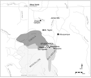
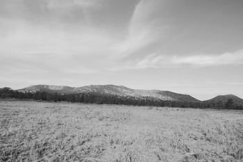
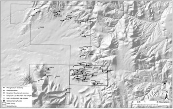
The Lion Mountain area (Figure 1) is located on the western edge of the Gallinas Mountains and borders the eastern edge of the Plains of San Agustin. A large portion of this area is on the Magdalena Ranger District of the Cibola National Forest Service (CNFS). Visually, Lion Mountain dominates the landscape (Figure 2). Topographically, elevations range from 2,134 to 2,438 meters (7,000 to 8,000 ft.), with gently sloping mesas and ridges separated by mostly westward-draining canyons and arroyos. Although a few springs dot the landscape, there are no permanent waterways. Higher elevations are dominated by Ponderosa pine forest, with pinyon-juniper woodland dominating lower elevations. Our survey area consists of 3.22 km2 (2 square miles) of the CNFS (Figure 3). This study area is defined by the sections of land we systematically surveyed, and it will increase in size as we continue our pedestrian survey.
Location of the Lion Mountain area in relation to cultural regions and geological features discussed in the text (figure drafted by Marion M. Coe).

Photo of Lion Mountain facing west from study area (photograph by Suzanne L. Eckert).

Our survey area (LMAP Survey), representing the South Settlement Cluster, and the Marshalls’ survey area (Marshall Survey), representing the North Settlement Cluster, within the larger study area. Note Gallinas Springs Pueblo (LA1178) to the east outside of both survey areas (figure drafted by Deborah L. Huntley).

Cultural-Historical Context
Historically, the Lion Mountain area is within or near traditional cultural areas for at least five present-day Native American tribes. The area was included as part of Zuni sovereign territory in 1846 as having been “held for centuries, against many aggressors” (Ferguson and Hart Reference Ferguson and Richard Hart1985:56–57). Specifically, the Lion Mountain area is identified as part of Zuni traditional hunting territory. The Acoma also identify the area as part of their traditional hunting territory (White Reference White1943), and they may have sought refuge in the area at various times during the Spanish colonial period (Marshall and Marshall Reference Marshall and Marshall2008). The Piro established a village just north of the modern town of Magdalena during the Spanish colonial period (Marshall and Walt Reference Marshall and Walt1984), and they may have ventured west into the Lion Mountain area to hunt or collect wild resources. Finally, both the Puertecito Navajo Band and the Chiricahua Apache recognize the area as part of their traditional home range, and they may have been in the area as early as the Spanish colonial period (Marshall and Marshall Reference Marshall and Marshall2008).
In terms of archaeological cultural traditions, the Lion Mountain area is located within the Rio Abajo district of the Rio Grande region as defined by Marshall and Walt (Reference Marshall and Walt1984) and expanded upon by Lekson (Reference Lekson and Adler1996; Figure 1). Residents of the Lion Mountain area also shared some material characteristics with two other regions defined by archaeologists: the Cibola region and the Mogollon region. The Rio Abajo, Cibola, and Mogollon regions exhibit similar trends through time, and their occupants are considered by many archaeologists to be Ancestral Pueblo groups whose descendants are the various Pueblo groups still living in the Southwest today. However, because these regions also differ in notable ways, researchers working in each of the three regions use somewhat different chronologies with different period and phase names. Here, we focus on similarities between the regions and employ five general eras: Preagricultural Foragers (ca. 10,500 BC–AD 200), Early Agriculturists (ca. AD 200–1000), Dispersed Agriculturists (ca. AD 1000–1175), Aggregated Agriculturalists (ca. AD 1175–1300), and Nucleated Agriculturalists (post–AD 1300; Table 1).
Various Phase/Period Names by Region and Dates.

Of special interest during the Dispersed agriculturalists era (ca. AD 1000–1175) are the socio-ritual developments in Chaco Canyon (approximately 200 km northwest of the study area) and the regions these developments eventually encompassed, including the Lion Mountain area. Beginning at approximately AD 850, large, multistoried masonry pueblos (great houses) with numerous ceremonial features (great kivas) were constructed in Chaco Canyon, located in Central New Mexico (Cordell and McBrinn Reference Cordell and McBrinn2012). The canyon became the center of the Chaco Phenomenon, a widespread cultural complex with integrated regional systems of trade and interaction characterized by the presence of Chaco outliers and roads throughout much of its sphere of influence (Judge Reference Judge, Crown and Judge1991; Lekson Reference Lekson and Lekson2006). Although the exact political and social nature of the Chaco Phenomenon continues to be of debate (Irwin-Williams Reference Irwin-Williams and Reed2008; Judge and Cordell Reference Judge, Cordell and Lekson2006; Kantner and Vaughn Reference Kantner and Vaughn2012; Neitzel Reference Neitzel2003; Sebastian Reference Sebastian and Doyel1992; Van Dyke Reference Van Dyke2007; Wills Reference Wills2009; Wills and Dorshow Reference Wills and Dorshow2012), its rise and eventual decline had a major impact on cultural developments around AD 850–1150 throughout much of the northern US Southwest.
By about AD 1150 in the Rio Abajo district, settlement began to shift to villages of aggregated room blocks or, in some instances, nucleated pueblos (defined below [Marshall and Walt Reference Marshall and Walt1984]). Researchers recognize three separate populations living within the district at this time: a large, local population indigenous to the area prior to AD 1100 (Lekson Reference Lekson and Adler1996; Marshall and Walt Reference Marshall and Walt1984; Wilson Reference Wilson, Duran and Kirkpatrick1995); a group of people expanding into the district from the Cibola region to the west (Lekson Reference Lekson and Adler1996); and an immigrant population speculated by some as having come from the Mesa Verde area (Davis and Winkler Reference Davis and Winkler1960; Lekson Reference Lekson1989, Reference Lekson and Adler1996; Wilson Reference Wilson, Duran and Kirkpatrick1995; see Figure 1). Understanding how residents of our study area fit into this “mixed but interesting cultural-historical dynamic” (Lekson Reference Lekson and Adler1996:172) is one of our research goals.
Another development especially pertinent to this research occurs during the Aggregated agriculturalists era (ca. AD 1175–1300) in the Zuni district of the Cibola region. The Pueblo III period (AD 1175–1275) is distinguished by various settlement patterns including dispersed masonry room blocks, aggregated masonry room blocks, aggregated masonry room blocks with a post-Chaco great house, and nucleated villages (Kintigh Reference Kintigh, Wills and Leonard1994, Reference Kintigh and Adler1996; Schachner Reference Schachner2012). Aggregation refers to sites consisting of compact clusters of contemporaneous room blocks that formed “communities of impressive size, with from 100 to nearly 500 total rooms” (Kintigh Reference Kintigh, Wills and Leonard1994:132), whereas nucleation refers to large pueblos built in a (semi-) planned fashion around one or more plazas. Post-Chaco great houses have many of the features of Chaco great houses, but they date to the period after the long-distance networks centered on villages in Chaco Canyon had ceased.
Previous Research in the Lion Mountain Area
Although numerous investigations (Cartledge Reference Cartledge2000; Cartledge and Benedict Reference Cartledge and Benedict1999; Marshall Reference Marshall2003; Marshall and Marshall Reference Marshall and Marshall2008; Nicoll Reference Nicoll2004, Reference Nicoll2009; Winkler and Davis Reference Winkler and Davis1961) have documented many sites within a few kilometers of the Lion Mountain area, archival data are limited in that (1) some sites were recorded many years ago with poor quality information; (2) some sites are on private land where access is denied; (3) surveys in the area were not always systematic, nor were they always conducted by professional archaeologists; and (4) in some instances, survey reports were never written. Consequently, although these archival data are informative, they must be considered incomplete. For example, the Magdalena Ranger District sponsored several Passport in Time (PIT) projects from 1998 through 2004. These PIT projects, conducted by Forest Service Heritage Resource specialists and volunteers, located and documented many sites in the Lion Mountain area. Unfortunately, assistant forest archaeologist Cliff Nicoll, who led the PIT team, passed away before completely reporting on the projects. It was Cliff who inspired us to begin our own research focused on the Lion Mountain community.
One project conducted over several years on the nearby Double H Ranch (Marshall Reference Marshall2003; Marshall and Marshall Reference Marshall and Marshall2008) has complete coverage, excellent documentation, and systematic ceramic counts. Initially, Marshall (Reference Marshall2003) documented a variety of small pueblo sites consisting of single rooms or small rockshelter camps with variable occupation dates likely during the tenth through fourteenth centuries AD. He suggests that these sites were used as garden areas and hunting camps. Marshall and Marshall (Reference Marshall and Marshall2008) conducted a reconnaissance sample survey that focused on areas and land forms typically found to have relatively high site density in various environmental zones. A total of 52 prehistoric archaeological site components (a site may have one or more components) were documented, all but one of which are within 1.61 km2 (1 square mile) of one another, and they appear to be associated with the Lion Mountain Site Complex discussed below. Most of these components date to the mid-eleventh through mid-thirteenth centuries AD. Given the quality and extent of this project's data, we include it in the current research.
The Lion Mountain Site Complex
Marshall and Marshall (Reference Marshall and Marshall2008:18) identify the Lion Mountain Site Complex as “sites which cluster in the Antelope Flats and Camelot Pueblo area [and determined] to be of late Pueblo III affinity, having St. Johns Polychrome as an indicator ca. 1150–1250 A.D.” Their survey documented this site complex on the Double H Ranch along the north end of the Lion Mountain area, and it also identified a group of sites interpreted as part of an earlier site complex (ca. AD 1050–1150) that maintained “a great kiva as a probable community building or ceremonial center” (Marshall and Marshall Reference Marshall and Marshall2008:18). Marshall and Marshall (Reference Marshall and Marshall2008) defined Lion Mountain Site Complex sites in their survey area as the North Settlement Cluster. To continue this nomenclature, the group of sites in our survey area is identified herein as the South Settlement Cluster.
Cultural regions defined by archaeologists are not necessarily those recognized by the people who lived within those regions. Our findings, discussed below, suggest that residents of the Lion Mountain Site Complex were economically and socially autonomous from the Rio Abajo, Cibola, and Mogollon heartland traditions outlined in the previous section. As a community, they constructed similar residential and ritual architecture, practiced corn horticulture that was probably supplemented with wild plant and animal resources, engaged in long-distance exchange networks, and produced their own local pottery tradition. In other words, they created and maintained a community landscape specific to the Lion Mountain area. Throughout the remainder of this article, we refer to the residents of Lion Mountain Site Complex as the Lion Mountain Community. We argue that the Lion Mountain Community was a group of people with a common identity and shared interests who were living together on a community landscape of their creation. Toward the end of their residency in the study area, however, the Lion Mountain Community was impacted by the presence of nearby immigrants who probably did not share their identity nor view the landscape in the same way. The implications of this are discussed further below.
Lion Mountain Archaeology Project: Methods and Approaches
Survey Methods
So far, we have completed a 100% systematic pedestrian survey of two 1.61 km2 (1 square mile) sections on the CNFS (Huntley and Eckert Reference Huntley and Eckert2020). In addition to documenting new sites, we attempted to locate and redocument all previously recorded sites in the survey area. Documentation included collecting data useful for establishing site chronology and social connections, such as systematic tabulating of ceramic artifacts and documenting architectural attributes. For several sites, Jeffrey Ferguson of the University of Missouri collected obsidian sourcing data using in-field ED-XRF analysis (Schaefer Reference Schaefer2020; Schaefer et al. Reference Schaefer, Ferguson, Eckert, Huntley and de Smet2019).
Ceramic Chronology Building
Given our reliance on in-field data, namely ceramic sherds visible on site surfaces, we are limited in our temporal data. Fortunately, there are well-established ceramic chronologies for Ancestral Pueblo regions that, when combined with mean ceramic dating, can provide initial date ranges for most of the sites discussed in this study. A mean ceramic date (MCD) is calculated by multiplying the total frequency of a ceramic type within an assemblage with its average manufacture date, summing this product for all ceramic types, and then dividing this sum by the total number of sherds (South Reference South1977). The technique was originally developed for historic sites where well-established production dates are available from the historic record. The technique is more problematic with prehistoric ceramic collections, for which specific date ranges are not usually known (Christenson Reference Christenson1994; Gomolak Reference Gomolak1980). To help address this problem, we used a script developed for R by Matt Peeples that uses a bootstrapping procedure to estimate the confidence interval associated with a given MCD. As explained by Peeples,
for each site, 1,000 bootstrapped replicates are created by resampling with replacement from the original data. The sample sizes for each row are held constant, equal to the total number of sherds in that row in the original data and with the probability of drawing each ceramic type determined by the actual proportions of that type in the observed sample. MCDs are then calculated for each of these bootstrapped replicates to provide a means of assessing sampling error associated with the original MCD. The script returns the upper and lower 95% confidence interval estimates associated with each MCD [Peeples Reference Peeples2011:1].
This approach provides a guideline for dating our sites that can be refined as absolute dates become available.
Architecture, Features, and the Built Landscape
Our survey identified archaeological site boundaries as discussed above, relying primarily on diagnostic pottery types to determine temporal components. However, each archaeological site is composed of one or more feature categories, and it is these features that help us to understand how people experienced their community landscape through different activities performed in different settings (Rapoport Reference Rapoport1990:11). We divide our survey data into three broad feature categories: nonresidential activity areas, residential architecture, and public architecture. We acknowledge that these categories were determined for features based solely on surface data, but a long history of archaeological work at Ancestral Pueblo sites provides us with confidence that our identifications are correct more often than not.
Nonresidential activity areas are features that present clear evidence of human use but limited to no evidence of architecture. The most common nonresidential activity area features in our study area are interpreted to be trash scatters/middens, garden plots, single-room structures that were used for activities other than habitation, and thermal features.
Architecture is an important part of the community landscape. It both reflects and influences the ideologies, activities, and behaviors of community members (Hillier and Hanson Reference Hillier and Hanson1984; Lawrence and Low Reference Lawrence and Low1990; Rapoport Reference Rapoport1969; Ryan Reference Ryan and Ryan2015a). Residential architecture includes features interpreted as domestic structures used by a single nuclear or small extended household. Activities performed in these structures included—but were not limited to—food preparation and service, storage, sleeping, tending the sick, production steps in some craft manufacture, child care, and general sheltering from inclement weather. In our study, residential architecture is most commonly represented by multiple-room masonry room blocks.
Public architecture includes features interpreted as structures constructed and used by more than one household. Ancestral Pueblo communities often combined public spaces (e.g., a plaza) with private spaces (e.g., a kiva) to benefit socially from both the integrative nature of group rituals and the power inherent in secrecy (Brandt Reference Brandt and Blackburn1977; Safi and Duff Reference Safi and Duff2016). Public architecture “transmits and validates social rules or schemas which, in turn, create and perpetuate social identity and integration” (Ryan Reference Ryan and Ryan2015a:102). In our study, public architecture features have one or more of the following attributes: elevated location, bi-wall structures, linear axes, multistory or overall tall rooms, large roofed or unroofed kivas, formal plaza spaces, and encircling berms (Safi and Duff Reference Safi and Duff2016; Stein Reference Stein, Fowler, Stein and Anyon1987; Vivian Reference Vivian, Huber and Van West2006). Although some domestic activities may have occurred within features we define as public architecture, we suspect that these features were used by more than one household and were important places for activities that created and maintained social cohesion. Furthermore, we argue that public architecture features were constructed as community focal points and that they displayed a grandeur and symbolism that was not present in features we define as residential architecture. Consequently, they would have become important features on a community landscape.
Lion Mountain Archaeological Project Results: Land Use Patterns
Our data, combined with Marshall and Marshall's (Reference Marshall and Marshall2008) data from the Double H Ranch project, resulted in the recording of the 100 sites reported here, 91 of which date to approximately AD 1000–1300 and are associated with the Lion Mountain Site Complex. Although we have assigned sites to a single era (Table 2) except in two cases where we are confident there are multiple components represented, we in no way intend for these eras to be considered hard temporal boundaries. Instead, we suspect that use of many residential sites crossed temporal boundaries (Figure 4) and that there is a trend toward the building up of the community landscape over time.
MCD and 95% confidence interval estimates for each site in the study, with a large enough diagnostic ceramic sample to perform the calculations (figure drafted by Robert Z. Selden Jr.).

Summary over Time of Built Features and Architecture in the LMAP Survey Area.

Note: Preagriculturists Era sites were assigned to time period based on diagnostic lithic artifacts. Except where indicated, all other sites were assigned to time period based on MCD as presented in Figure 4.
* Twenty sites did not have an adequate sample size of diverse types to provide an MCD with a confidence interval; these sites were assigned to time period based on presence/absence of diagnostics ceramic types alone and are indicated with an asterisk.
Although we discuss earlier sites briefly below, it is the development and maintenance of the Lion Mountain Site Complex as it reflects the Lion Mountain Community landscape that is of interest here. This landscape would have played a role in maintaining community identity as residents lived through broad demographic and ritual changes throughout the Ancestral Pueblo world—including the expansion and the shrinking of the Chaco Phenomenon, the development and spread of new ceremonial practices, and the establishment of a nearby immigrant village.
Preagricultural Foragers Era (ca. 10,500 BC–AD 200)
Previous research on Paleoindian and Archaic occupation of the greater region argues that the focus on preagricultural groups was immediately west of the study area, at the relatively lower elevation of the paleolake shorelines in the northeastern portion of the Plains of San Agustin (Hill and Holliday Reference Hill and Holliday2011). Evidence for the presence of preagricultural use in the study area comes primarily from five sites (Table 2), consisting of chipped stone artifact scatters typically located on flat sandy areas in elevated positions on the landscape (Figure 5). When present, diagnostic lithic artifacts date these sites to the Middle or Late Archaic period. We, along with Marshall and Marshall (Reference Marshall and Marshall2008), interpret these sites as hunting stations and activity areas that support the notion that this area has a long history of use.
Location of Preagricultural Foragers Era and Early Agriculturists Era sites (figure drafted by Deborah L. Huntley).

Early Agriculturists Era (ca. AD 200–1000)
Evidence for the presence of early agricultural sites in the Lion Mountain area follows the typical pattern for the greater region. Four sites (Table 2), three of which may be possible pithouse villages (Figure 5), were identified. Late in the period, one site is dominated by a large pit structure suspected to be a great kiva. Temporally, this kiva straddles the end of this era and the beginning of the next; it is interpreted as the earliest evidence of community architecture in the study area; and it may have served to ritually integrate the local pithouse residents of both the North and South Settlement clusters. We argue below that its location is the foundation for what will become the Lion Mountain Site Complex's ritual core.
Dispersed Agriculturalists Era (ca. AD 1000–1175) – Early Lion Mountain Site Complex
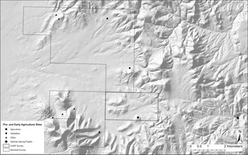
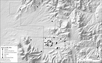
During this era, we see the initial development of the Lion Mountain Site Complex with the building of a Chaco outlier, multiple residential room blocks, and formal agricultural features in the form of isolated rooms and garden plots (Figure 6).
Location of Dispersed Agriculturalists (Early Lion Mountain Site Complex) sites (figure drafted by Deborah L. Huntley).

Bobcat Pueblo (LA125085) is the only Chaco outlier identified in the Lion Mountain area (Figure 7). Following Safi and Duff (Reference Safi and Duff2016), we determined that Bobcat Pueblo in all probability has at least seven of the 13 listed characteristics of a Chaco outlier: elevated location, linear axis, possibly multistory, berm, masonry-enclosed plaza, probable great kiva, and a related community. The remaining six characteristics—earthen platform, core-and-veneer masonry, banded masonry, compound walls, overly tall rooms, and blocked-in kiva—cannot be determined without excavation. The great house was constructed on a natural outcrop located on the crest of a ridge, and it commands an excellent view of the area to the south, west, and north—including Lion Mountain (Figure 2) and the Plains of San Agustin. The location also provides a view of both the North and South Settlement Clusters. Diagnostic sherds on the surface are typical of both the Cibola and Mogollon regions. It is noteworthy that the ceramic assemblage is nearly identical to Largo Gap (LA3918), a site located approximately 120 km west of the study area, the nearest identified Chaco outlier (Safi and Duff Reference Safi and Duff2016). The majority (72%) of obsidian identified on the surface of Bobcat Pueblo was derived from Mt. Taylor and Jemez Mountain sources (Schaefer Reference Schaefer2020), whereas less material (24%) was derived from the relatively local McDaniel Tank source. Mt. Taylor and Jemez Mountain are the dominant obsidian assemblages at Chaco Canyon sites as well (Duff et al. Reference Duff, Moss, Windes, Kantner and Steven Shackley2012), further supporting the interpretation that Bobcat Pueblo is a Chaco outlier.
Map of Bobcat Pueblo (LA125085), the Chaco outlier identified in this study (figure drafted by Suzanne L. Eckert and Marion M. Coe).

Along with Bobcat Pueblo, 18 masonry-style residential sites—six with multiple room blocks—date to this era. These sites are all within 4 km (2.5 miles) of Bobcat Pueblo and are identified here as the Early Lion Mountain Site Complex. Only one of these sites has been identified as possibly having a small kiva. It is assumed that residents of both the North and South Settlement Clusters turned to Bobcat Pueblo for ceremonial practice. Given the architectural characteristics of Bobcat Pueblo, this practice probably integrated with the regional ceremonies associated with the Chaco Phenomenon. Although the outlier was situated in a visually prominent location, the room blocks themselves may have been situated on the landscape, in part to take advantage of productive agricultural locations (for a similar argument at the Largo Gap outlier, see Safi and Duff Reference Safi and Duff2016). The nine contemporary sites associated with agricultural activities are the first visible modifications of the local landscape to create formal garden spots (Lekson Reference Lekson and Adler1996) and probably reflect the community's intensification of agricultural practice. Although the distance between many room blocks with each other and Bobcat Pueblo does not necessarily suggest day-to-day interaction among all community members (Varien Reference Varien, Varien and Wilshusen2002), agricultural practice would have required day-to-day interaction with the landscape. As with the outlier, diagnostic painted sherds on the surface of residential room blocks are typical of both the Cibola and Mogollon regions, whereas locally produced utility ware often include smudged and burnished interiors commonly observed in Mogollon brown ware.
Aggregated Agriculturalists Era (ca. AD 1175–1300) – Late Lion Mountain Site Complex
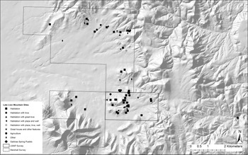
During this era, we see the expansion of the Lion Mountain Site Complex with the building of multiple post-Chaco great house sites, an increase in the number of residential room blocks, and continued creation of formal agricultural features in the form of isolated rooms and garden plots (Figure 8).
Location of Aggregated Agriculturalists Era (Late Lion Mountain Site Complex) and post-1300 sites (figure drafted by Deborah L. Huntley).

Soon after the collapse of the Chaco Phenomenon, multiple sites with ceremonial features were constructed within the study area that forms the core of the Lion Mountain Site Complex. Seven of these sites are located within 2 km (1.2 miles) of the Chaco outlier of the previous period and probably served most of the community. However, four sites with ceremonial features, including an isolated great kiva (LA159512) and Camelot on the San Agustin (LA5975) are notably some distance from the core ceremonial sites, and they may have either served a different purpose or reflect a ceremonial splitting of the community into factions. Although it is unclear whether all of these sites were built at once, they had to have been built within at least a few decades of one another, based on ceramic dating. Many of these sites have the same characteristics as Chaco outliers, and they could be called post-Chaco great house sites as described for the Zuni region to the west (Kintigh Reference Kintigh, Wills and Leonard1994; Schachner Reference Schachner2012). For example, although the Nicoll Site (LA121885) has two probable multistory room blocks and a potential kiva, its most striking feature is an unusual circular, “double” enclosing wall (Figure 9). The double wall appears to be continuous, and in several areas, especially in the northeast site portion, cross walls are visible. The interior subdivisions created by the cross walls appear too small to be residential rooms. But each post-Chaco great house is different in its size and makeup of ceremonial features. For example, whereas the Nicoll Site displays the double enclosing wall, Camelot on the San Agustin has a berm, and LA121884 has a possible unroofed great kiva (Figure 10).
Map of Nicoll Site (LA121885), a post-Chaco great house site identified in this study (figure drafted by Suzanne L. Eckert and Marion M. Coe).

Photo of possible unroofed great kiva (crew member standing in center) at LA121884, a post-Chaco great house site identified in this study (photograph by Suzanne L. Eckert).

Fifty-one masonry-style residential sites, 13 with multiple room blocks, date to this era and are interpreted as being the residences of the community served by the various post-Chaco great house sites. An additional 10 sites were identified either as generalized activity areas or as isolated rooms or garden plots associated with agricultural activities. As with the previous era, diagnostic artifacts for all sites during this era are typical of the Cibola and Mogollon regions, with locally produced utility ware that often is smudged and burnished on the interior of vessels. However, the obsidian source for this era is markedly different from the previous one: the majority (67%) of obsidian identified on the surface of the five post-Chaco great house sites analyzed was derived from the relatively local McDaniel Tank source, suggesting a possible constricting of networks—or at least not as strong a connection to the north once the Chaco Phenomenon had collapsed.
Important to this era is the construction of Gallinas Springs Pueblo (LA1178), approximately 6.5 km (4.0 miles) east of the Nicoll Site (LA121885). This multistory, nucleated pueblo consists of approximately 300–500 rooms along with a number of internal kivas and small plazas (Danson Reference Danson1957; Lincoln Reference Lincoln2007). The site is split by an arroyo, with rooms having been built upward along both banks of the arroyo. Unlike the rhyolite-masonry room blocks of the Lion Mountain Site Complex, Gallinas Springs Pueblo was constructed with a combination of shaped tabular sandstone and unshaped cobble masonry. The decorated ceramic assemblage is dominated by a carbon-paint ceramic type dated to AD 1240–1300; this carbon-paint type stands in stark contrast to the mineral-paint types encountered at contemporaneous sites discussed above (Ferguson et al. Reference Ferguson, Laumbach, Lekson, Nelson, Schollmeyer, Laumbach and Miller2016; Lincoln Reference Lincoln2007; Winkler and Davis Reference Winkler and Davis1961). Whereas the Late Lion Mountain Site Complex obsidian assemblage is dominated by material from the relatively local McDaniel Tank source, the Gallinas Springs Pueblo assemblage is dominated (83%) by material from Mt. Taylor. Combined, the Gallinas Springs Pueblo village layout, masonry style, dominant decorated ceramic type, and obsidian source patterns are substantially different from the contemporary pattern at Late Lion Mountain Site Complex sites. These differences have led numerous researchers to speculate that Gallinas Springs Pueblo was inhabited by immigrants, possibly from the Mesa Verde area (Danson Reference Danson1957; Ferguson et al. Reference Ferguson, Laumbach, Lekson, Nelson, Schollmeyer, Laumbach and Miller2016; Lincoln Reference Lincoln2007; Winkler and Davis Reference Winkler and Davis1961). Even if not inhabited by immigrants, this site is different enough that its residents clearly were not participating in the same social, cultural, and religious practice of the residents of the Lion Mountain Site Complex.
Post–AD 1300
In the Lion Mountain area, only one site (LA130064), located in the South Settlement Cluster (Figure 8), has an MCD into the AD 1300s (Figure 4). This site is comparable to other residential sites from the previous period, and we suspect that it represents one of the later members of the Late Lion Mountain Site Complex. By the early 1300s, the Lion Mountain Site Complex appears to have come to an end, with no other construction within the Lion Mountain area. Although there is no obvious use of the immediate area based on pottery types, there are fourteenth-century sites within the greater vicinity that may be descendant communities or that may have housed residents that used resources within the Lion Mountain area.
Summary
Although there is evidence of human occupation in the study area starting in preagricultural times, the Lion Mountain area began to support a permanent population during the Early Agriculturalists Era. Late in this era, a large ceremonial feature was constructed at one site, which may have served to integrate the local community in both the North and South Settlement Clusters. The Early Lion Mountain Site Complex began to be constructed sometime after AD 1000, and it consisted of masonry room blocks and agricultural features along mesa slopes and a Chaco outlier dominant on the landscape. After the collapse of the Chaco Phenomenon, there was a building up of the community landscape, with the Late Lion Mountain Site Complex eventually consisting of over 64 residential room blocks, garden plots, and other agricultural features along mesa slopes, as well as multiple post-Chaco great house sites, each with a different suite of ritual structures. The material culture of the study area is its own blend of Mogollon- and Rio Abajo–style utility ware, Cibola- and Mogollon–style painted ware, and Cibola-style architecture. The local settlement pattern follows the Cibola region pattern as observed in the Zuni district, with dispersed room blocks around a Chaco outlier followed by an aggregated community around post-Chaco great house sites (Kintigh Reference Kintigh, Wills and Leonard1994, Reference Kintigh and Adler1996; Schachner Reference Schachner2012). The density and nature of great house sites in the study area varies in some ways when compared with western counterparts, but they still have many of the same Chaco-inspired features. By the early 1300s, the Lion Mountain Site Complex appears to have come to an end, with residents of the study area moving out of the immediate vicinity, possibly in response to the presence of an immigrant village nearby.
The Lion Mountain Community Landscape
As discussed above, Liebmann (Reference Liebmann2017) cautioned against relying on a strict, direct historical approach when attempting to understand ancient community landscapes. We find Liebmann's warning particularly appropriate for our study, given that we are working in an area that has no immediate descendant community living in it. Instead, it has multiple modern tribes that partially trace their history to it. Although we will never be able to know all the specific social and religious significance embodied in the Lion Mountain Site Complex, we argue that considering it through both a forward-looking and backward-looking lens provides some insights into the nature of the Lion Mountain Community landscape while also addressing the concerns outlined by Liebmann.
The Lion Mountain Community Landscape in Time and Space
Looking forward in time relative to the Lion Mountain Community, we use Anschuetz’s model of Pueblo community landscapes (Reference Anschuetz2014, based on Ortiz Reference Ortiz1969) couched in an ethnographic understanding of historic and modern Pueblo villages. Anschuetz’s model recognizes a center focused on the oldest village plaza, middle reaches where agriculture and hunting were practiced, and sacred places on the slopes of the surrounding cardinal mountains. Although there is no direct analog to the oldest village plaza in the Lion Mountain Site Complex, we argue that a community “center” is evident within the 3 km2 (1.9 square miles) where the Early Agriculturalists Era great kiva, the Chaco outlier, and the majority of post-Chaco great house sites were built. This 3 km2 area also has the highest density of residential room blocks. This center would serve much the same purpose as the oldest plaza in modern villages, providing the social and religious focus for multiple generations of the community. However, the construction of four sites with community ritual architecture outside this center in the Aggregated Agriculturalists Era suggests either divergence from this ethnographic analogy or a possible factionalism between the North and South Settlement clusters during this time.
As Anschuetz describes it, “Fields and plant gathering areas predominate among the valleys and hills in the middle reaches of a community’s landscape, which . . . give way to hunting tracts . . . in the mountain foothills” (Reference Anschuetz2014:12). Similarly, the Lion Mountain Site Complex center was surrounded by agricultural features and activity areas identified in our survey, as well as other residential room blocks. In addition, the natural environment would have provided residents with access to wild plant and animal as well as geological resources. Finally, Anschuetz states that “the summits of the sacred cardinal mountains, which are the essential counterparts of a community center, are the domain of ritual leaders who are keepers of some of their respective community’s most privileged traditional cultural knowledge” (Reference Anschuetz2014:12). If one stands within the 3 km2 (1.9 square miles) defined above as the Lion Mountain Community center, then Lion Mountain is visible to the west and southwest, and numerous peaks are visible to the north, east, and south. Although we cannot be certain, it is very possible that at least some of these peaks served as visual reminders of sacred knowledge and as markers of the boundaries of the Lion Mountain Community landscape.
Looking forward in time, we use ethnographic analogy to argue that the community landscape of the period shared many hallmarks associated with ethnographic Pueblo groups. We recognize that this is a very archaeological perspective. Although we cannot reconstruct with any certainty which landmarks or built spaces played a central role in the Lion Mountain Community identity over time, we can speculate that the community landscape paralleled cosmological layouts similar to many ethnographic Pueblo groups, suggesting that historically documented concerns over fertility, rain, and well-being have a deep history.
People eventually ceased residing in the Lion Mountain Community, and they have not been traced either archaeologically or ethnographically. Consequently, we can only speculate about where the residents of the Lion Mountain Community “looked forward” to and how this would have affected their immediate situation and future. They may not have taken all aspects of a Chaco-inspired landscape with them when they left the Lion Mountain area, but they may very well have taken the social memory of their community landscape, which eventually transformed into aspects of the Pueblo cosmology that we see today.
Looking backward in time provides a different, although not contradictory, understanding of the Lion Mountain Community landscape. During the Early Agriculturalists Era, the settled population in the study area increased dramatically. Although the population seems to have continuously increased over the next two centuries based on the number of room blocks, we do not know for sure where this “new” population came from. Local pottery technology and design suggest an affinity with both the Mogollon and Cibola regions, but that does not necessarily mean that people moved in from those regions. During the Early Agriculturists Era, the first known great kiva in the area was constructed. This great kiva initially served to integrate local populations ritually, but it also likely continued to be a meaningful landmark once it was no longer regularly used. We argue that it was the earliest ritual feature in the community “center” and, even once it was “abandoned,” it would have served as a reminder of the residents’ long history in the area. As with other Chaco great house sites (Cameron Reference Cameron2008; Cameron and Toll Reference Cameron and Toll2001; Durand Reference Durand2003; Safi and Duff Reference Safi and Duff2016), we argue that during the Dispersed Agriculturalists Era, Bobcat Pueblo was a locally constructed great house emulating the monumental architecture of Chaco Canyon, and it served as the ritual focus for the Early Lion Mountain Site Complex. As with other Chaco great house communities (Kantner Reference Kantner1996; Ryan Reference Ryan and Ryan2015a; Safi and Duff Reference Safi and Duff2016; Van Dyke Reference Van Dyke1999), we argue that Bobcat Pueblo would have served to help integrate households of possibly diverse backgrounds (as evidenced through pottery) through ritual practice (as evidenced through architecture), provide access to the greater Chaco network (as evidenced through pottery and obsidian), and create a visual representation of the community center (as evidenced through the prominence of the Chaco great house on the landscape).
To look backward in time, we combine practice theory with the concept of social memory to argue that residents of the area created a community landscape focused on ritual architecture that began as participation in the greater Chaco System but, as that system collapsed, became one of emulating the past through construction of multiple post-Chaco great houses. These post-Chaco great house structures would have continued to integrate residents of the area through ceremony and practice that may have emulated, although not faithfully reproduced, ceremonies of a bygone era. Over time, as more landmarks on the landscape were created over multiple generations, social memory would have worked to both maintain and help to transform community identity because landmarks served as regular reminders. A part of that landscape would have been interaction with other communities—networking with other communities that lived on different landscapes or facing the presence of a new community living on their own landscape but defining it differently. These moments of contact would have served to help maintain some aspects of community identity while stimulating change of other aspects.
The collapse of Chaco Canyon and its great house network must have had important social and ritual consequences for the residents of the Lion Mountain Community centered on Bobcat Pueblo. In response, community members refocused their ritual practice by choosing to build multiple ceremonial sites, each exhibiting a slightly different suite of ritual architectural features. These post-Chaco great house sites clearly emulate Bobcat Pueblo to some extent, and they are assumed to have served a similar integrative purpose (as evidenced through ritual features). Although regional networks seemed to have constricted (as evidenced through obsidian data), affinity with the Mogollon and Cibola regions continued (as evidenced through pottery). However, why multiple post-Chaco great house sites were built within less than a century, including some outside of the “ritual center” as identified above, is a question not answerable with current data. Do these great houses represent competing factions? Complementary ritual specialists? Sequential use due to ritual experimentation? Hopefully, future excavations can address these questions.
As noted by Ryan (Reference Ryan and Ryan2015a), architecture is only one part of a built environment, and it needs to be considered within the broader framework of agricultural fields and other extramural activity areas, water and other natural resources, cosmological features (including cardinal directions), and unique natural landmarks. It is these aspects of the community landscape that continued even as Bobcat Pueblo and some contemporaneous residential sites were abandoned for newer buildings. But these old buildings were not abandoned ideologically. Instead, they became ruins on the community landscape, with their own associated stories and memories. Consequently, we see the building up of the Lion Mountain Community landscape during the Aggregated Agriculturalists Era with the building of both new great house and residential sites, the expansion of agricultural fields and other activity areas, and the creation of ruins that housed previous generations.
The Lion Mountain Community Landscape, Collective Memory, and Practice
The concept of community landscape describes the space in which people lived, but it does not explain how it helped to define and maintain identity. For that, we turn to a discussion of practice and collective memories. Collective memories are a community's shared stories and history of its past that help to shape its identity (Halbwachs Reference Halbwachs1950). They are passed on through the practice of sharing knowledge through teaching and storytelling. It is this practice of sharing memories and their associations on the community landscape (Ryan Reference Ryan and Ryan2015b)—a field associated with the history of a founding family, a peak associated with the memory of an ancestral spirit, a grove associated with the story of hero's death, a ruin associated with the heyday of Chaco ritual—that worked to help maintain or change the community's identity over time. But this identity would not have been passed on only through sharing; landmarks on the landscape would have been physical reminders of these collective memories. As generation after generation lived within the area, it would have become impossible for a resident to walk over the community landscape and not be reminded at some point of collective memories that reinforced the community identity.
It is the practice of sharing knowledge with the next generation that also would have allowed for changes in community identity. As more and more generations lived on the community landscape, more and more collective memories associated with specific landmarks were available to be shared. Additional stories and histories would have been added, changing collective memories. As memories were shared from one generation to the next and then the next, subtle (or not so subtle) changes in the telling would also have occurred. Over time, which collective memories were shared more often, when they were shared, and by whom, would have worked to reinforce some aspects of the community's identity while downplaying other aspects. It this sense, then, the community landscape would have helped to maintain, influence, and change community identity through time as associations with collective memories were created through the practice of sharing knowledge.
The Lion Mountain Community Landscape and Culture Contact
At some point in the thirteenth century, the 300–500 room site of Gallinas Springs Pueblo was built and occupied by a group of people that evidence suggests were not from the immediate region. We do not know exactly when this village was built in relation to the post-Chaco great house sites of the Lion Mountain Site Complex. Whether or not the residents of Gallinas Springs Pueblo were immigrants from Mesa Verde is a topic for a different article. What is pertinent to our understanding of the Lion Mountain Community is that the residents of Gallinas Springs Pueblo had a very different aesthetic in terms of architecture and pottery technology, and they were tied into a different set of regional networks. Inferred from these distinctions are differences in social organization, religious practice, possibly language, and community identity. Furthermore, the presence of Gallinas Springs Pueblo on the landscape would have resulted in changes to the Lion Mountain Community landscape. We suspect, but cannot confirm at this time, that the residents of Gallinas Springs Pueblo had their own community identity as reflected in a different material culture, and for this reason, probably began to form their own community landscape within the region that maintained and affirmed their group identity.
Two different communities living within less than 10 km (6.2 miles) of one another would have led to opportunities for culture contact between a diverse range of participants in a variety of contexts. Such encounters would have had the potential for considerable influence on the social, political, cultural, and religious life of actors who have been exposed to “the other” (Heinz and Linke Reference Heinz, Linke, Maran and Stockhammer2012) as they lived together within the region. Although there is currently no evidence of warfare or violence between the two communities, the Gallinas Springs Pueblo community would have taken up space on the landscape. This would have resulted in Lion Mountain Community members not being able to move through the landscape with the same amount of freedom or indiscretion as they had previously. Access to some resources may have been contested, and other forms of competition may have arisen as members of each community opted to identify themselves through different practices (Bayman and Sullivan Reference Bayman and Sullivan2008).
The nearness of the Gallinas Springs Pueblo community would also have increased the chance of Lion Mountain Community members regularly running into people who did not speak as they did, dress as they did, or make pottery as they did. In such culture-contact contexts, people are likely to consciously reconstruct their identities as they mull over what it means to be “us” versus “them” (Eckert Reference Eckert, Harry and Roth2019). It is possible that the presence of the Gallinas Springs Pueblo community sparked the construction of the multiple post-Chaco great houses as residents of the Lion Mountain Community worked toward a greater visual dominance on their landscape. It is equally possible that the Gallinas Springs Pueblo community led to increased factionalism among Lion Mountain Community residents as they were exposed to new ideas that were either more or less attractive to different members of the community. It is possible that the residents of Gallinas Springs Pueblo were welcomed as refugees or as ritual specialists, but it is also possible that the residents of this Pueblo were neither welcomed nor particularly tolerated. It is possible that a mix of these scenarios occurred, or that something entirely different happened. At this point in our research, we cannot be confident about the nature of changes that resulted from the presence of the Gallinas Springs Pueblo community. We can nevertheless be certain that the Lion Mountain Community, which its residents had spent two centuries creating and maintaining, did change.
Conclusion
We argue that the Lion Mountain Site Complex, as a physical reflection of the Lion Mountain Community landscape, helped to both maintain and transform community identity for multiple generations of residents. This community landscape was ancient in that it covered at least three centuries of continuous occupation, and its residents witnessed the introduction of agriculture, the rise and fall of the Chaco Phenomenon, the Great Drought, and probably other major events that had important social consequences at the time but that are lost to history. We suggest that, in the last era for which we have archaeological evidence, a second community landscape may have been created with the arrival of immigrants into the area who had a different relationship with the environs. At this time, no systematic survey has been conducted around this immigrant community, so further interpretation is difficult until such work can be done.
Reconstructing community landscapes and their associated community identities based on archaeological data requires (at least) three elements. The first is representative survey results, especially when examining change through time. Although the arid region of the American Southwest makes it possible for archaeological remains from most time periods to be highly visible on the ground surface, we acknowledge that certain ancient activities are archaeologically invisible, which means that archaeological reconstructions of any aspect of the past are never complete. The second requirement for examining how community landscapes work to maintain or transform community identity over time is good chronological control. Within the study area, we are fortunate to have well-established ceramic chronologies that can be used to provide initial date ranges for most sites based upon surface samples alone. However, we again recognize our limitations, acknowledging that sites with deep stratigraphy may have earlier components that we have missed in this analysis. Third, and finally, understanding how this site complex reflects the Lion Mountain Community landscape and the associated community identity is strengthened by multiple lines of evidence linking particular archaeological patterns with particular past practice. Specifically, we use a dual temporal approach by considering our data from two perspectives: “looking back” and “looking forward” in time relative to the residents living on the Lion Mountain Community landscape.
We began this article with a quote from Hodgetts (Reference Hodgetts2013) about how communities create landscapes and how landscapes also create communities as memories and stories become linked with specific places. We have argued for exactly this is our study area. Although there are undoubtedly challenges to reconstructing community landscapes and the way they integrate with community identity, a dual temporal approach embedded within a framework of practice theory and social memory allows us to shed light on how landscape and identity work together to create the social and physical context in which people lived.
Acknowledgments
This article is dedicated to Cliff Nicoll (1957–2015), who worked as the assistant forest archaeologist for the Cibola National Forest and National Grasslands in New Mexico for 24 years. Portions of this project were paid for by the Arizona State Museum Burgan Fund. We would like to thank our team of volunteers, especially Timothy De Smet, Carl Evertsbusch, Jeffrey Ferguson, Teressa Gregory, Alesha Marcum-Heiman, Fran Maiuri, and Jonathan Schaefer; the staff at the CNFS Magdalena District Office and the CNFS Albuquerque Supervisors Office: Dennis Aldridge, Tina Cason, Suzanne DeRosier, Manuel Martinez, Linda Trujillo, and Kim Obele. A special thank you goes to Matt Basham (then of CNFS, now of BLM) for that first day of walking the sites and to CNFS archaeologists Jeremy Kulisheck, Blair Mills, and Kathryn Turner for their insights, wisdom, and patience. Thanks to the staff at ARMS for access to records, and to Michael Brescia for the Spanish abstract. We also thank the anonymous reviewers whose thought-provoking comments helped to greatly improve our manuscript.
Data Availability Statement
All site information from our survey and archival site data discussed in this article are available through the New Mexico Cultural Resource Information System (NMCRIS) database administered by the Archaeological Records Management Service (ARMS) of the New Mexico Historic Preservation Division, New Mexico Department of Cultural Affairs; and through the US Forest Service archaeological site files and Geographic Information System (GIS) database administered by the CNFS Albuquerque Supervisors Office.