Introduction
A detailed knowledge of the composition of the flora and of the principal vegetation communities in continental Antarctica (treated here as the main mass of the continent and excluding the Antarctic Peninsula) is urgently needed as it is realized that the terrestrial ecosystem may provide one of the earliest indicators of global climate change, particularly through the influence of increased temperatures (Petersen & Howard-Williams Reference Petersen and Howard-Williams2001). Temperatures in some parts of Antarctica are rising, particularly in the maritime Antarctic (Oppenheimer Reference Oppenheimer1998). Around the northern Antarctic Peninsula, temperature rises have led to significant losses in the floating ice shelves and also in significant range extensions southward of the two indigenous flowering plants (Fowbert & Smith Reference Fowbert and Smith1994, Smith Reference Smith1994) whilst in other areas temperatures are thought to be falling slowly (Turner Reference Turner2004, Turner et al. Reference Turner, Colwell, Marshall, Lachlan-Cope, Carleton, Jones, Lagun, Reid and Iagovkina2005), although Steig et al. (Reference Steig, Schneider, Rutherford, Mann, Comiso and Shindell2009) present evidence for a warming trend that is much more widespread than previously acknowledged. Laboratory studies on the soil fauna from the McMurdo Dry Valleys, Ross Sea region, suggest that drastic changes in composition or dominance may occur (Doran et al. Reference Doran, Priscu, Lyon, Walsh, Fountain, McKnight, Moorhead, Virginia, Wall, Clow, Fritsen, Mckay and Parsons2002).
Our knowledge of the vegetation of continental Antarctica is derived predominantly from a small number of studies in the vicinity of major stations in coastal regions (e.g. Filson Reference Filson1966, Reference Filson1974, Horikawa & Ando Reference Horikawa and Ando1967, Kuc Reference Kuc1968–69, Longton Reference Longton1972, Reference Longton1973, Seppelt & Ashton Reference Seppelt and Ashton1978, Kappen Reference Kappen1985, Broady Reference Broady1986, Smith Reference Smith1988, Reference Smith1999, Schwarz et al. Reference Schwarz, Green and Seppelt1992, Melick et al. Reference Melick, Hovenden and Seppelt1994, Seppelt et al. Reference Seppelt, Broady, Pickard and Adamson1988, Reference Seppelt, Green and Schroeter1995, Ling & Seppelt 1998, Seppelt Reference Seppelt2002) and more rarely from surveys covering larger areas (Castello & Nimis Reference Castello and Nimis1995, Cannone & Seppelt Reference Cannone and Seppelt2008). The vegetation is composed entirely of cryptogams. Algae and cyanobacteria dominate the ephemerally wet basins and stream areas (Howard-Williams & Vincent Reference Howard-Williams and Vincent1989, Howard-Williams et al. Reference Howard-Williams, Pridmore, Downes and Vincent1989, Vincent et al. Reference Vincent, Howard-Williams and Broady1993, Tang et al. Reference Tang, Tremblay and Vincent1997, Vincent Reference Vincent2000). In localities where at least ephemeral moisture is plentiful, bryophytes (mosses and one liverwort Cephaloziella varians) may form extensive patches but generally their occurrence is patchy, while in dryer areas their biomass is often exceedingly low. Lichens are found in a wide variety of habitats, on rock, sand, mosses, weathered feathers and bones, but rarely is cover or biomass very great. They may also occur within rocks as endoliths and, in the Dry Valleys, this is the most common vegetation type over many square kilometres of the valley floors, predominantly on the northern faces of suitable moraine boulder debris and country rock outcrops. Botanical “hot spots” having substantial vegetation cover are known from the Canada Glacier, Taylor Valley and from Botany Bay, Granite Harbour in southern Victoria Land; Edmonson Point in central Victoria Land; Beaufort Island in the Ross Sea; Cape Hallett and Birthday Ridge, northern Victoria Land; and the Windmill Islands, Wilkes Land. The vegetation of continental Antarctic regions is a reflection of the rigours of the cold desert environment where plant distribution is limited primarily by the availability of free water (Kennedy Reference Kennedy1993), although in some localities such as the Windmill Islands, soil nutrients derived from relict penguin colonies are also important in determining abundance (Beyer et al. Reference Beyer, Bölter and Seppelt2000a, Reference Beyer, Pingpank, Wriedt and Bölter2000b).
Despite some 60 years of scientific exploration, the vegetation of the McMurdo region, southern Victoria Land (77–80°S, 160–168°E), remains relatively poorly understood or documented. The first attempt at a vegetation classification was that of Longton (Reference Longton1973) using a modified version of the classification developed by Gimingham (Reference Gimingham1967) and Gimingham & Smith (Reference Gimingham and Smith1970) for the maritime Antarctic. Longton recognized eleven plant sociations. The overwhelming impression from this study is one of an impoverished continental Antarctic terrestrial flora. Only three mosses and eight lichen species were named and high cover and biomass were found only in dense moss patches associated with regular meltwater areas. Schwarz et al. (Reference Schwarz, Green and Seppelt1992) carried out a detailed study of one of the larger bryophyte patches, located at the Canada Glacier flush, Taylor Valley (then Site of Special Scientific Interest SSSI 12, now Antarctic Specially Protected Area ASPA 131). Although biomass was locally high with cover up to 100%, only three mosses Bryum argenteum, B. pseudotriquetrum and Hennediella heimii were found, the last with aborted sporophytes (Seppelt et al. Reference Seppelt, Green, Schwarz and Frost1992). Two lichen species were subsequently reported growing on the sides of small stones in the melt stream arising from the side of the glacier and draining through the moss flush (Green et al. Reference Green, Seppelt and Schwartz1992). Species lists are available for two other sites in the McMurdo Dry Valleys region, namely Kar Plateau (76°56′S, 162°20′E) (Seppelt et al. Reference Seppelt, Green and Schroeter1995, Reference Seppelt, Green and Schroeter1996) and Beaufort Island (76°57′S, 166°55′E) (Seppelt et al. Reference Seppelt, Green and Skotnicki1999). The north end of Beaufort Island represents an interesting site with a moss bed c. 1 ha in area with nearly 100% cover composed almost entirely of one species, Bryum argenteum, and only a very minor cover of Hennediella heimii. At Cape Hallett (72°19′S, 170°16′E), northern Victoria Land, a similar situation occurs with extensive vegetation dominated by Bryum argenteum and filamentous green algae occurring on an ephemerally wet beach terrace, where high nutrient input and atmospheric ammonium from penguins and skua gulls may limit diversity.
Seppelt & Green (Reference Seppelt and Green1998) published a bryophyte flora for southern Victoria Land which included seven moss species and the liverwort Cephaloziella varians. All these species can be found at one of the most botanically diverse areas of continental Antarctica - Botany Bay, Granite Harbour (77°S, 162°E). The first collections of plants from this region were made by the National Antarctic “Discovery” Expedition 1901–04 (Cardot Reference Cardot1907). The western geological party of the British Antarctic Expedition of 1910–13 was based at Cape Geology, at the northern end of Botany Bay, but no plant collections appear to have been made (Schroeter et al. Reference Schroeter, Green and Seppelt1993).
We have undertaken extensive fieldwork in the Granite Harbour region over a number of summer seasons, commencing with a preliminary survey in December 1989. Detailed studies on the flora, vegetation, ecology, photosynthetic physiology of mosses and lichens, and floristic and landscape mapping began in 1992 and concluded in January 2008. The Botany Bay–Cape Geology area is now very justifiably designated as Antarctic Specially Protected Area 154, to conserve and protect the unique biological richness of the site.
Unless otherwise stated, nomenclature for mosses follows Ochyra et al. (Reference Ochyra, Lewis Smith and Bednarek-Ochyra2008). Nomenclature for lichens follows Øvstedal & Lewis Smith (Reference Øvstedal and Lewis Smith2001). Nomenclature for liverworts follows Bednarek-Ochyra et al. (Reference Bednarek-Ochyra, Váňa, Ochyra and Smith2000).
Study area and methods
Site description
Botany Bay and Cape Geology are situated in the south-western corner of Granite Harbour, southern Victoria Land, at 162°32′52″E, 77°00′14″S, c. 100 km north-west of Ross Island. The area consists of raised boulder beach terraces, weathered rocky steppes and irregular rock platforms around Cape Geology, rising rapidly to the south to include a well-defined elevated cirque containing a small ice field. The bedrock geology at Cape Geology has been described as a porphyritic grey biotite-granite, with phenocrysts of orthoclase of reddish colour, casting the weathered rock with a reddish tinge (Antarctic Treaty Secretariat: http://www.ats.aq/e/ep_protected.htm). The area faces north and is well protected from strong winds. The impact of the sun is also magnified by the sea ice sheet that normally remains in Granite Harbour until about the end of January so that light levels are very high. Sensors in the same plane as the lichens recorded incident PFD (photon flux densities) up to 2800 μmol m-2 s-1, about 40% above normal full sunlight. Cape Geology and Botany Bay, in particular, are much warmer than expected and air temperatures can reach almost 10°C with some days in early January being almost frost free (Schroeter et al. Reference Schroeter, Green, Pannewitz, Schlensog and Sancho2010).
The area is extremely rich botanically for such a high-latitude location - it is also one of the richest sites in the whole of continental Antarctica. There is a high diversity and abundance of lichens (more than 30 species) and mosses (nine species), and the structure and development of these communities are similar to those found 10° of latitude further north. Some lichen thalli (e.g. Umbilicaria aprina) measure up to 15 cm diameter. The boulder beach has rich populations of both epilithic and endolithic lichens. The area is the type locality for the lichens Buellia frigida (Darbishire Reference Darbishire1910) and Caloplaca coeruleofrigida (Søchting & Seppelt Reference Søchting and Seppelt2003). The area contains by far the most southerly record of an hepatic, Cephaloziella varians, and the mosses Bryoerythrophyllum recurvirostrum and possibly Ceratodon purpureus (Seppelt & Green Reference Seppelt and Green1998). There are abundant growths of algae (at least 85 taxa), although the algal flora is not considered particularly unusual for the locality (Broady Reference Broady2005).
There are large populations of invertebrates (collembola, mites, nematodes, rotifers) and the area is the type locality for the collembolan Gomphiocephalus hodgsoni. There is a colony of between 40–50 breeding pairs (and numerous non-breeders) of the south polar skua (Catharacta maccormicki). These numbers are approximately the same as those present in 1911–12 (Taylor Reference Taylor1913, Reference Taylor1916). No other bird species are known to breed in the Cape Geology area, although Adélie penguins occasionally come ashore to moult. Nutrient input from skuas, from meltwater percolating from the ice covered slopes to the west, and occasionally from the sea when the sea ice breaks out, plays a significant part in determining the abundance of the biota, together with water availability from snowmelt and ephemeral melt streams.
Ecological survey
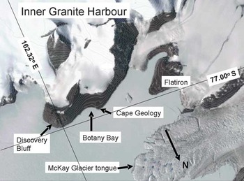
Relevées were located within the altitudinal range 5–40 m above sea level at three primary locations: Botany Bay, Cape Geology, and the beach terrace near the designated campsite c. 1 km south-west of Cape Geology (Fig. 1). 186 relevées were recorded using either 50 cm x 50 cm or 20 cm x 10 cm quadrats. Species presence was noted and in the larger quadrats, cover estimates were made visually. For the smaller quadrats, cover estimates were obtained using point intercepts at 1 cm intervals with the frame gridded using fine fishing line and the point intercept being that point at which the lines crossed in grid corners. Field estimations of cover values using visual assessment or point quadrats maintained an accuracy of ± 1%. Within relevées lichen substrates were recorded as saxicolous, terricolous or muscicolous.
Map of inner Granite Harbour showing the location of Botany Bay (162°32′52′′E, 77°00′14′′S), and other major named features. Note how Botany Bay is north facing and well protected from winds coming from the ice shelf (to the left) and the polar plateau via the McKay Glacier.

Botany Bay was also mapped in detail using a building level to obtain altitude above sea level and plant distribution mapped using subjective categories which reflected the major plant type or species present.
Data analysis
The classification of data from visual estimates and the 186 relevées by “two-way indicator species analysis” was carried out using TWINSPAN 1.0 (Hill Reference Hill1979) at default settings. This is a dual technique, providing classification of samples and species. Groups of samples are characterized by a characteristic species combination, or at least a group of differential species (Økland Reference Økland1990). Further ordination analysis was carried out using a detrended correspondence analysis (DCA) (Hill & Gauch Reference Hill and Gauch1980) using the program CANOCO 4.0 (ter Braak & Smilauer Reference Ter Braak and Smilauer1998).
Results
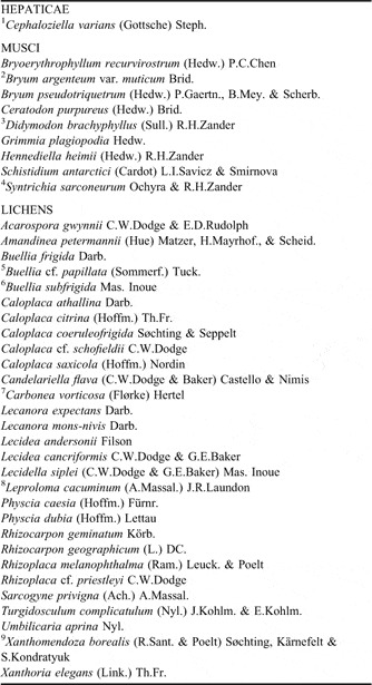
The terrestrial lichen and moss flora of Botany Bay–Cape Geology comprises one liverwort, nine mosses, and at least 30 lichens (Table I). Several lichen species attributable to Buellia and Lecidella remain as yet undetermined. Cyanobacteria, particularly Nostoc, and green algae, particularly Prasiola crispa, are also abundant in the region.
Bryophytes and lichens of the Botany Bay–Cape Geology region, Granite Harbour, Victoria Land, Antarctica.

Notes:
1. Cephaloziella varians has previously been referred to as C. exiliflora (fide Bednarek-Ochyra et al. Reference Bednarek-Ochyra, Váňa, Ochyra and Smith2000).
2. Bryum argenteum var. muticum has previously been referred to as Bryum subrotundifolium (fide Ochyra et al. Reference Ochyra, Lewis Smith and Bednarek-Ochyra2008).
3. Didymodon brachyphyllus has previously been referred to as Didymodon gelidus (fide Ochyra et al. Reference Ochyra, Lewis Smith and Bednarek-Ochyra2008).
4. Syntrichia sarconeurum has previously been referred to as Sarconeurum glaciale (fide Ochyra et al. Reference Ochyra, Lewis Smith and Bednarek-Ochyra2008).
5. Buellia cf. papillata, growing on moss, has previously been referred to as Buellia grimmiae.
6. Buellia subfrigida has previously been referred to as Aspicilia glacialis (Seppelt et al. Reference Seppelt, Green and Schroeter1995) and Hymenelia glacialis (Øvstedal & Lewis Smith Reference Øvstedal and Lewis Smith2001).
7. Carbonea vorticosa has previously been referred to as Lecidea blackburnii (Seppelt et al. Reference Seppelt, Green and Schroeter1995).
8. Leproloma cacuminum has previously been referred to as Lepraria sp.
9. Xanthomendoxa borealis has previously been referred to as Xanthoria mawsonii (see Lindblom & Søchting (Reference Lindblom and Søchting2008).
The classification of the vegetation of the Cape Geology–Botany Bay region includes five lichen-dominated sociations and two moss dominated sociations within the Crustaceous Lichen and Foliose–Fruticose Lichen subformations and Short Moss Turf and Cushion subformation, with one algal dominated sociation within the Alga subformation (sensu Longton Reference Longton1979). Because of the co-association of both crustose and foliose lichens over much of the region we have chosen not to adopt the subformation categories of Longton (Reference Longton1979). Consequently, the vegetation is classified at the sociation level.
Antarctic nonvascular cryptogam tundra formation
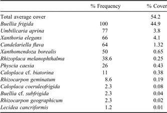
1. Buellia frigida sociation
This sociation occurs primarily on granitic boulders on the raised beach terraces, and sheltered sides of massive country rock risers, steppes and terraces. Water availability is primarily derived from snow deposits (the boulders can be almost covered by winter snowfall), by snowmelt from adjacent snow patches or, very occasionally, by summer snowfall. In Botany Bay, the south- and south-west-facing (i.e. towards the cliffs inland) sides of boulders are covered (almost 100%) by crustose lichens while the north- and north-east-facing (i.e. towards the frozen sea) sides are mostly devoid of lichen cover. This effect is so strong that when viewed from the sea ice the boulders in the bay appear to have no lichen cover at all. Nutrients are derived from snowmelt and from direct deposition of guano derived from the local breeding skua gull population. Plant composition in the 70 relevées is summarized in Table II.
Buellia frigida sociation composition.

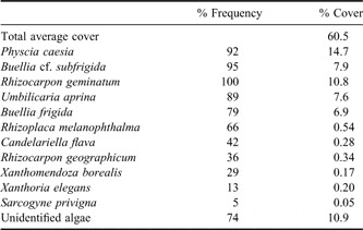
2. Physcia caesia–Buellia subfrigida sociation
This sociation is predominant in areas of meltwater flow along ephemeral streams or melt channels and where there is regular melt seepage over rock. The two dominant species are largely restricted to these habitats in the region. Physcia caesia and, to a much lesser extent Physcia dubia, often form pronounced lines along streams and channels in such a position that the thalli are regularly covered with water at peak flow each day. Cyanobacteria and chlorophycean algae are often present in these habitats but were not identified in this study. Plant composition in the 38 relevées is summarized in Table III.
Physcia caesia–Buellia subfrigida sociation composition.

3. Umbilicaria aprina–Rhizocarpon geographicum sociation
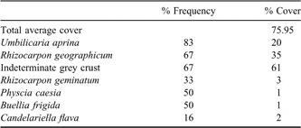
This sociation is found on sheltered, humid and well-watered vertical rock faces or along melt seepage or drainage over stepped ledges and ice fractured country rock. Moisture and shelter appear to be the principal determining ecological parameters. Plant composition in the six relevées is summarized in Table IV.
Umbilicaria aprina–Rhizocarpon geographicum sociation composition.

4. Xanthomendoza borealis sociation
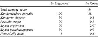
This sociation is found primarily on sandy gravels and coarse sandy soils and on rock faces in dryer habitats where there is considerable ornithogenic nutrient input. Often the patches of gravel and sand are found in shallow depressions, on ledges and on level areas of country rock where snow and meltwater collect. Plant composition in the 13 relevées is summarized in Table V.
Xanthomendoza borealis sociation composition.

5. Caloplaca citrina sociation
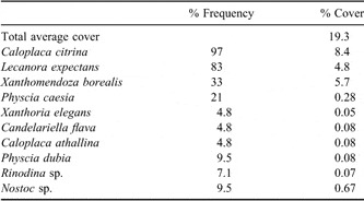
This sociation is found on moss cushions and turf and is dominated by nitrophilous lichens. The moss species are primarily Hennediella heimii, Bryum pseudotriquetrum and, to a lesser extent, Bryum argenteum. It is found in areas where there is considerable nutrient enrichment from skua gulls. Moisture is primarily derived from melting snow. Plant composition in the 42 relevées is summarized in Table VI.
Caloplaca citrina sociation composition.

Short Moss Turf and Cushion subformation
6. Ceratodon purpureus sociation
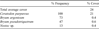
This sociation is found on moist ledges and on sandy or silty soils amongst moraine debris and ice rounded boulders, particularly on the raised beach terrace at Botany Bay. In terms of water flow this is the wettest part of the area. The dominant moss is Ceratodon, but Bryum pseudotriquetrum and, to a lesser extent, other mosses such as Schistidium antarctici and Bryum argenteum may be found. Plant composition in the 30 relevées is summarized in Table VII.
Ceratodon purpureus sociation composition.

7. Bryum argenteum–Bryum pseudotriquetrum sociation
This sociation is strongly associated with melt streams and pools, particularly on the raised beach terrace in Botany Bay. The richest bryophyte communities occur where moisture is derived directly from melting snowdrifts and along melt seepage channels and ephemeral streams, or near temporary shallow pools. Reproduction and dispersal is almost entirely by asexual propagules and is particularly prevalent for B. argenteum. Plant composition in the 24 relevées is summarized in Table VIII.
Bryum argenteum–Bryum pseudotriquetrum sociation composition.

Alga subformation
8. Prasiola crispa sociation
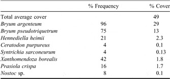
This sociation occurs on nutrient rich sandy soil in habitats that are sheltered and receive moisture from snowdrifts. Cover, however, may be low. In nine relevées, cover of Prasiola was only 1.8%, with total average cover only 2%.
Ordination analysis
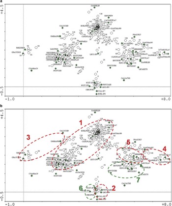
The ordination produced some clear groupings that coincide mainly with those obtained by the sociation analysis (Fig. 2). One difference is the separation into two parts on the ordination of Buellia frigida sociation 1, one dominated by B. frigida and the other by Rhizoplaca melanophthalma, Umbilicaria aprina and several epiphytic cyanobacterial and algal groups. The spread of this group indicates that there is more than one habitat on these boulders which have snowmelt from above and high humidity from water running between them below, as well as a strong effect from bird fertilization leading to the presence of many nitrophilous lichen species. A defining feature of this sociation is that liquid water is rarely present.
For caption see next page

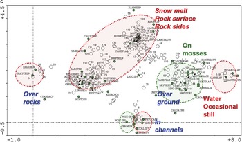
Two-dimensional ordination of the species and sample plots based on detrended correlation analysis (DCA) of the cover values of the species. The dimension of the axes is SD-units (standard deviation) so that the variance of the distribution of the species is shown in this biplot. The position of each sample in the biplot is determined by the species occurring in it. The species names have been abbreviated to the first four letters of the genus and the first three of the species, the number following the name classifies the type of occurrence: 7 = species on cobbles and boulders, 8 = species on mosses, and 9 = species on soil. b. As for a but with the sociations produced by the ordination marked with dotted lines. Red lines are lichen dominated and green lines, moss dominated. In each case the number corresponds with the sociation number in the text. c. As for a & b but with the form in which water occurs given for each sociation. Snowmelt means that the water is generated in situ by melting whilst the other categories indicate the water is flowing or ponding and comes from sources outside the Bay. The dotted lines relate to habitat types and different associations (e.g. 5, 7) may occupy the same or similar habitat.

The remaining sociations reflect the presence of water, whether flowing or still, as well as the type of substrate. Sociation 2 is dominated by Physcia caesia which, in this area and many other sites along the Ross Sea coast, forms a clear line along runnels with fluctuating water levels. Typically the lichen is submerged only at high flows. This contrasts with the ecology of the species in temperate areas where it is in no way associated with water flows. Sociation 6, which is bryophyte dominated, falls in the same location on the ordination and is dominated by Ceratodon purpureus. In this case the most probable difference is the less stable substrate. Flowing water over unstable but not steep substrates is the location of the second bryophyte dominated sociation, sociation 7, with high cover of Bryum pseudotriquetrum and B. argenteum and this is a very typical occurrence in the Ross Sea region when there is the correct combination of an excellent, regular, slow flowing water supply together with good shelter. Flowing water over a sheltered but well lit rock surface are the apparent conditions for sociation 3, dominated by U. aprina and Rhizocarpon geographicum. Again, for the latter species, this is not the expected habitat from its alpine ecology. Sociation 5, characterized by a dominance of Caloplaca citrina, with the lichens growing primarily on mosses. This is a habitat that is marginal to the main water flows and one in which the lichens do not suffer flooding but clearly obtain a good water supply from the moss beneath them. The presence of nutrients from birds and somewhat drier conditions seems to determine the occurrence of this sociation. Sociation 4, characterized by the presence of Xanthomendoza borealis, occurs typically on periodically wetted, but often unstable rock ledges with a strong bird nutrient influence. The alga Prasiola crispa can occur in similar sites, especially those with pooled water.
The analysis clearly indicates the importance of the type of water supply, its regularity, the substrate type, and particularly in Botany Bay, the influence of nutrients derived from the local bird population.
Botany Bay vegetation map
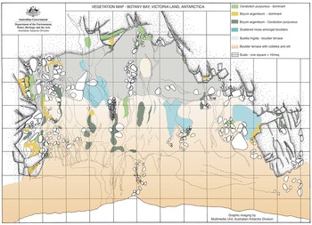
Vegetation zonation and topography in Botany Bay are shown in Fig. 3. Shape and topography of the seaward margin is influenced by annual events relating to sea ice. With breakout of the sea ice, there is opportunity through ice push to shape the topography. However, while creating disturbance at the seaward margin of the bay, this has little influence on the vegetation. Meltwater passing over areas of moss, particularly B. argenteum, results in the release and subsequent deposition of deciduous apical shoot propagules along the melt channels. Establishment of the moss colonies in the sand and boulders at the shore is almost impossible as the habitat is too unstable.
Vegetation map of Botany Bay, Granite Harbour, southern Victoria Land. Grid interval = 10 m.

Discussion
Since we first visited the area and began the detailed mapping and ecological surveys there has been little obvious change in plant distribution patterns. However, under the influence of global warming trends, increased water flow through or over the vegetation may lead to change. Drainage lines may become wetter or drier, depending on the direction of melt flow over the raised beach terrace, leading to changes in the distribution pattern of the vegetation. Our detailed vegetation map can be used as a baseline reference to monitor such changes.
In the Windmill Islands, the only other continental Antarctic region where vegetation mapping on a large scale has been undertaken, there has been appreciable change in the vitality of moss beds over the last 10 years (R. Seppelt, S. Robinson and J. Wasley, personal observations) due to changes in the moisture regime of the habitat. At the Canada Glacier, Taylor Valley, increased summer meltwater flow over the large moss flush has resulted in pronounced lateral spread of the moss. If the warming trends continue to influence continental Antarctic regions we may expect significant change to the extent of the moss cover. Careful and accurate mapping of the vegetation in selected areas such as these (particularly Canada Glacier, Botany Bay, Beaufort Island and Cape Hallett in Victoria Land, the Windmill Islands region, Wilkes Land) has provided an important tool for assessing the impacts of climatic change on the continental Antarctic terrestrial ecosystem.
The surveys carried out in this investigation fully confirm that Botany Bay is one of the richer sites for lichen and bryophyte biodiversity in continental Antarctica. The total of 29 lichen, nine moss and one liverwort species is practically identical to the numbers reported for Wilkes Land by Smith (Reference Smith1988), a site that is about 11 degrees latitude further north (66°S compared to 77°S for Botany Bay). Around thirty lichen species are also reported for Casey and Davis stations, also at about 66°S latitude (Green et al. Reference Green, Schroeter and Sancho2007). It is probable that Edmonson Point, Terra Nova Bay, has higher numbers of species but the 56 species reported from there (Castello & Nimis Reference Castello and Nimis1995) include lichens from several sites further north. The similarity in total species numbers across the whole of continental Antarctica suggests that the cline in biodiversity seen as one moves south along the Antarctic Peninsula (Peat et al. Reference Peat, Clarke and Convey2007) does not continue over continental regions. Further indicators of the special nature of Botany Bay are the southernmost records in Antarctica for a liverwort, Cephaloziella varians, for the lichen Turgidosculum complicatulum, for the moss Bryoerythrophyllum recurvirostrum and probably also for Ceratodon purpureus. Most are about three degrees latitude further south than the nearest record to the north in the Terra Nova Bay area.
The results of the vegetation analysis also agree in the main with those of Smith (Reference Smith1988) for Wilkes Land and Cannone & Seppelt (Reference Cannone and Seppelt2008) and Castello & Nimis (Reference Castello and Nimis1995) for central and northern Victoria Land, respectively. The latter two studies covered a larger geographic spread than this study and the level of agreement suggests that there is limited diversity of vegetation types in the Ross Sea region. Our groups 1 and 2, B. frigida sociation on rocks and the P. caesia dominated fluvial sociation, agree with 2A and 2B of Cannone & Seppelt (Reference Cannone and Seppelt2008). Similarly, our groups 3 and 4 correspond to group 3, our group 5 to group 4, and the bryophyte dominated groups 6 and 7 to groups 6.1 and 6.2 of Cannone & Seppelt (Reference Cannone and Seppelt2008). The main determinants of the occurrence of the different sociations appears to be the source of water, whether solely from snowmelt or snowfall, or from some form of melt stream. Sites influenced primarily by snow cover are lichen dominated while those influenced by meltwater are either mixed bryophyte/lichen or, in the wetter places, bryophyte dominated. Sociations are also influenced by the regularity and speed of water flow, and the type of substrate, especially whether it is loose gravel or solid rock. Some species show different ecologies in Antarctica compared to their temperate or alpine habitats or even from elsewhere in Antarctica. Rhizocarpon geographicum is typically found in Botany Bay and nearby localities where water flows slowly over a near vertical solid rock surface. Physica caesia is found as a distinct line along watercourses at a level where it is regularly submerged each day at peak summer melt flow. Neither species is associated with flowing water elsewhere. The moss C. purpureus is typically reported from drier sites in flushes, such as at Edmonson Point (Smith Reference Smith1999), but it occurs in the wettest habitats at Botany Bay.
Possibly the greatest difference between Botany Bay and the other sites to the north is the complete absence of Usnea species. This is not easy to explain as U. antarctica is reported from Kar Plateau, just across Granite Harbour from Cape Geology, and U. sphacelata is reported from 84°S at Mount Kyffin, in the southern Ross Sea. Abundant populations of U. sphacelata and U. antarctica also occur on Ross Island at sites that are visible from Cape Geology. In contrast, the specimens of Umbilicaria aprina at Botany Bay are some of the larger specimens reported in Antarctica and were reported to be as large as dinner plates by Scott’s western geological party in 1912 (Schroeter et al. Reference Schroeter, Green and Seppelt1993).
The generalization of Smith (Reference Smith1988) that three main groups occur, one dominated by lichens, one by bryophytes and a third in which lichens are epiphytic on bryophytes seems to hold. There seems little doubt that the extremely moderate summer climate in Botany Bay, the excellent water supply and nutrient input from the skua colony are the main determinants of the rich vegetation. The north facing aspect, the enhanced radiation from the almost ever-present sea ice and protection from strong winds afforded by cliffs to the south and west, means that very warm conditions occur for about two months each year. At the beginning of January there are a small number of days that are almost frost free with maximal air temperatures close to 10°C. The presence of the corrie to the south and above the Bay, and of a perched ice field above, ensures a steady source of meltwater in summer. Winter snowfalls appear to also be regular but not excessive, only about 40 cm depth in total. Shallow snowfalls are advantageous in this area as late lying snow acts as an insulator, keeping the ground cold and delaying the onset of active metabolism (Pannewitz et al. Reference Pannewitz, Schlensog, Green, Sancho and Schroeter2003) until air temperatures are warmer and water supply more reliable. Even so, it is dangerous to assume that a high visible biomass also means high productivity. The studies by Kappen et al. (Reference Kappen, Schroeter, Green and Seppelt1998) clearly show that B. frigida thalli on boulders are only active for a small number of hours each year. At least for this species, growth rates are exceedingly variable, ranging from 1.0 mm per 100 years in the Taylor Valley to 6.9 mm per 100 years at Cape Hallett (72°S) (Sancho et al. Reference Sancho, Green and Pintado2007).
We are now able to compare descriptions from three sites at about 77°S latitude: Canada Glacier flush, an extensive area of bryophyte dominated vegetation in lower Taylor Valley (Schwarz et al. Reference Schwarz, Green and Seppelt1992); Beaufort Island, an area of c. 1 ha of almost pure B. argenteum on a north facing slope backed by a glacier wall and with an extensive skua colony (Seppelt et al. Reference Seppelt, Green and Skotnicki1999), and Botany Bay (present study). A comparison on the basis of lichens is not possible as they are almost absent except at Botany Bay. The bryophytes are interesting in that there are only three species at Canada Glacier, ten at Botany Bay (one liverwort) and two (one dominant moss and one very minor) on Beaufort Island. A possible explanation for these differences could be the level of external nutrition. There is almost no external nutrient supply at Canada Glacier except that brought by dust or glacier meltwater. At Botany Bay there is a moderate input from the small skua colony and at Beaufort Island a significant input from the extensive skua colony. It appears that there may be an optimal nutrient level for bryophyte biodiversity and that too little, or especially an excess, will lead to lowered species numbers. It is also of note that at Cape Hallett, where there is an extensive bryophyte flush adjacent to skua nests and a very large Adélie penguin colony, there is only one moss species, B. argenteum, in the main flush area. This is an equivalent situation to Beaufort Island and suggests that only B. argenteum can take advantage of these high nutrient zones. In other coastal areas of continental Antarctica, such as the Syowa Coast (40°E) (Kanda Reference Kanda1981, Reference Kanda1987, Kanda & Inoue Reference Kanda and Inoue1994), B. argenteum is the dominant moss near to the shore, but to the east, between 50°E and 160°E, this species appears to be absent, being replaced by B. pseudotriquetrum.
Despite the growing interest in the possible effects of climate change on Antarctic vegetation it seems that we are a long way from being able to successfully predict vegetation shifts in the Ross Sea region. In the maritime Antarctic Peninsula a clear biodiversity cline exists and must depend on a climatic variable, probably water availability. However, in the Ross Sea region there is little evidence of a clear cline, similar vegetation types seem to exist all along the coast and even to more distant sites, like Wilkes Land. This is almost certainly a result of the desert conditions with suitable habitats only becoming available where a regular and substantial water supply is available. In the Windmill Islands (66°S) there has been a marked rapid change in the vitality of the moss-dominated areas (Melick et al. Reference Melick, Hovenden and Seppelt1994, Melick & Seppelt Reference Melick and Seppelt1997, Wasley et al. Reference Wasley, Robinson, Lovelock and Popp2006, Seppelt et al. unpublished observations) with an increase in abundance of epiphytic lichen cover and moribund moss being associated with a drying of the vegetation. Distributional changes, particularly in algae and mosses and probably relating to altered water flows have also been reported from Cape Hallett (Brabyn et al. Reference Brabyn, Green, Beard and Seppelt2005, Reference Brabyn, Beard, Seppelt, Rudolph, Türk and Green2006. Some properties of the vegetation, like lichen growth rate (Sancho et al. Reference Sancho, Green and Pintado2007), DNA damage in mosses following greater exposure to higher levels of incident UV radiation (Turnbull & Robinson Reference Turnbull and Robinson2009), and changes in flavonoid chemistry resulting from changes in atmospheric ozone levels (Ryan et al. Reference Ryan, Burne and Seppelt2009) do seem to be possible indicators of climate change. However, without an assessment of changes in water availability the actual vegetation, both its structure and biodiversity, does not appear to offer sufficient sensitivity to be of use as an indicator at the moment.
Acknowledgements
We thank Antarctica New Zealand for provision of logistic support and the University of Waikato, through their Antarctic Research Program, for their continuing support for Antarctic research over many years. BS and SP gratefully acknowledge financial support from the Deutsche Forschungsgemeinschaft (SCHR 473/4-3). TGAG was supported by a Ramon y Cajal Fellowship at Vegetal II, Farmacia, Universidad Complutense, Madrid, Spain, and by FRST grant: Understanding, valuing and protecting Antarctica’s unique terrestrial ecosystems: Predicting biocomplexity in Dry Valley ecosystems, during the writing of this paper.