

Since 1990, a total of 29 “billion-dollar disaster events” of riverine flooding in the United States have resulted in 453 deaths and more than $115 billion in damages to property, infrastructure, agriculture, homes, and businesses. 1 Over the past century, the amount of precipitation and the number and frequency of heavy rain events have increased, particularly in the US Northeast and Midwest; these trends are, with “high confidence,” expected to increase. Reference Hayhoe, Wuebbles and Easterling2 In addition to their economic devastation, floods have major impacts on the ability of health-care facilities (HCFs) to provide vital services to communities, negatively impacting population health. During flood events hospital administrators have had to choose between risky options: evacuate patients or attempt to continue functioning without reliable electrical power, clean water, and the ability of staff to get to and from work safely. Reference Peters3,Reference Toner, McGinty and Schoch-Spana4 Flooding presents a similar dilemma to administrators of long-term care facilities. 5
Riverine and coastal flooding has also resulted in the closure of dialysis facilities. In the immediate aftermath of Hurricane Sandy in 2012, people in need of hemodialysis presented to Manhattan emergency departments for dialysis that would normally be done in an outpatient setting. Reference Jangi6 Dialysis facilities remained closed for long periods of time, and patients often were unable to undergo dialysis as scheduled in New Orleans, Louisiana, following Hurricane Katrina in 2005 Reference Anderson, Cohen and Kutner7 and in Puerto Rico following Hurricane Maria in 2017. Reference Bonilla-Félix and Suárez-Rivera8 In addition to hospitals, long-term care facilities, and dialysis centers, pharmacies have also been impacted by flooding. After Hurricane Sandy struck, emergency departments saw surges of patients seeking to get prescriptions filled, as many pharmacies were unable to operate. Reference Jangi6
Given the increases in heavy precipitation across large parts of the United States, President Obama issued Executive Order 13690, which established a new Federal Flood Risk Management Standard aimed to reduce the risk and cost of future flood disasters. 9 Critical infrastructure—which included hospitals—were to be protected to withstand a 500-y flood. This executive order was revoked by Executive Order 13807 in August, 2017, 10 a loss to health-care preparedness for flooding. Prior publications about hospital flood preparedness have evaluated available tools for hospital disaster preparedness, including several criteria such as logistics and resources, human resources, triage and medical care, procedures and protocols, and training and exercise. Reference Nekoie-Moghadam, Kurland and Moosazadeh11 Based on a systematic review of the literature, we are aware of no studies that describe the extent to which HCFs are found in floodplains or how those responsible for preparedness determine if HCFs are in floodplains.
The Centers for Disease Control and Prevention’s (CDC) Climate-Ready States and Cities Initiative promotes climate change preparedness in the public health sector by applying the Building Resilience Against Climate Effects (BRACE) framework. 12 The University of Illinois at Chicago (UIC) is 1 of 16 states and 2 cities to receive CDC funding to use the BRACE framework to prepare Illinois for the health consequences of climate change. Flooding is the number 1 trigger for federal disaster declarations in Illinois. 13 To understand how flood preparedness of HCFs is addressed, a convenience sample of 10 county-level public health and emergency preparedness specialists in Illinois participated in 30-minute individual semi-structured key informant interviews. Verbal consent was obtained from each informant. A BRACE-Illinois team member developed the interview guide, 2 others revised it, and a CDC evaluation specialist reviewed and edited it before it was used. None of the specialists had seen a map of HCFs in relation to floodplains, although several indicated that such maps would be useful.
Based on that information, we sought to answer the following questions: (1) Are Illinois HCFs located in floodplains? (2) To what extent are emergency preparedness professionals and HCF administrators aware of local facilities in floodplains? (3) Would an interactive Web-based map of floodplains and HCFs (WBMFHF) be useful to preparedness professionals and HCF administrators?
Methods
Map Data
The primary source of floodplain data was obtained from the Federal Emergency Management Agency Flood Map Service Center. 14 Additional data were obtained from the Illinois State Water Survey’s preliminary 1% annual chance floodplain delineations for the following counties in Illinois: Ford, Warren, DuPage, Will, Pulaski, and areas in the Little Wabash HUC8 watershed. 15 Geospatial data about HCFs other than pharmacies came from the Illinois Department of Public Health (IDPH) 16 and were manually geocoded; pharmacy data were obtained from ArcGIS Online publicly available datasets. 17 Data were uploaded into ArcGIS Online to create the publicly available map. That initial map was then revised based on feedback obtained from GIS and preparedness specialists of a local health department in Illinois.
Survey Research
With guidance from a CDC evaluation specialist, a 17-question survey about flood preparedness was developed using Qualtrics (QualtricsXM, Provo, Utah). The link to the baseline survey was distributed by IDPH to regional and local (county-level) emergency preparedness and response coordinators by means of email. To include as much representation as possible from emergency preparedness professionals in Illinois, representatives from the Illinois Emergency Services Management Association, the Illinois Health Care Association, the Illinois Center for Assisted Living, the Illinois Nursing Home Administrators Association, and the Illinois Health and Hospital Association distributed a formatted email with the survey link by means of membership email listservs. Participants had 4 weeks to complete the presurvey. Links were then sent to the flood preparedness map and a short video tutorial explaining how to navigate the map. Four weeks later, the link to the follow-up survey was emailed by means of the same listservs.
Data Analysis
Microsoft Excel was used to summarize survey data.
Human Subjects Research Protections
The protocol for this research was granted an exemption by the UIC Institutional Review Board (protocol 2018-0929).
Results
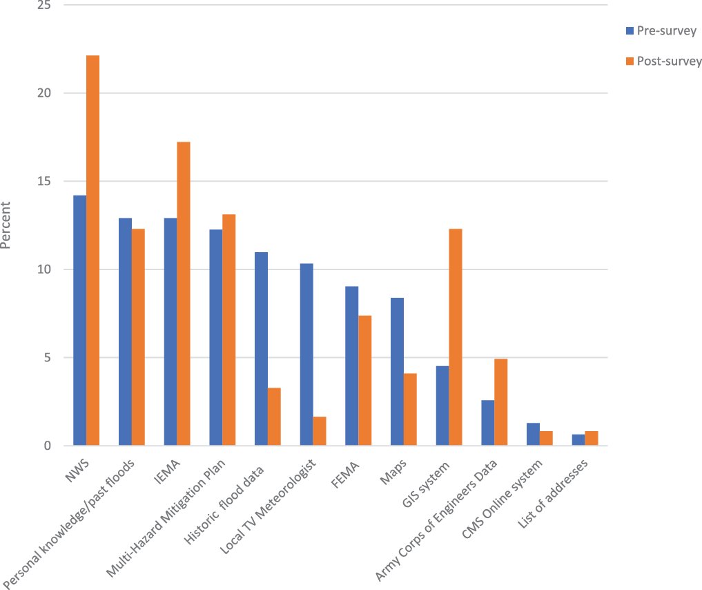
One hundred four participants fully or partially completed the baseline survey and 73 fully or partially completed the follow-up survey. Forty-eight percent of Illinois’ 102 counties were represented in the baseline survey and 54% in the follow-up survey. Forty-two percent of respondents represented hospitals or long-term care facilities in the baseline survey, while that group represented only 12% in the follow-up survey. The majority of respondents stated they do not have a GIS specialist at their organization in the baseline survey (70%) and follow-up survey (61%). Figure 1 summarizes the 2 main sources of information (2 per respondent) in planning for floods. The percentage of specific information sources noted by respondents were similar both before and after the interactive WBMFHF was distributed, although in the follow-up survey the frequency of relying on historical data (17% pre vs 4% post) and TV meteorologists decreased (16% vs 2%), while the frequency of using a GIS-based tool (7% vs 15%) increased.
Respondents’ top 2 sources of information used in planning for flooding. NWS, National Weather; IEMA, Illinois Emergency Management Agency; GIS, geographic information system; CMS, Centers for Medicare & Medicaid Services. N = 104 respondents presurvey, and N = 73 respondents postsurvey distribution of the WBMFHF.

The interactive WBMFHF, available at https://univofillinois.maps.arcgis.com/apps/Cascade/index.html?appid=6818abe83b6a4dbf93b32725c4d17b01, allows users to visualize the data at state, county, city, and HCF levels. Shading differentiates between the 1996 100-y and 500-y floodplains. Colors differentiate between the various types of HCFs. Clicking on individual HCFs provides additional information about the facility and whether it is in a 100-y (1% annual risk of flooding) or 500-y (0.2% annual risk of flooding) floodplain. A total of 4221 HCFs were identified. Fifty-three percent were pharmacies, 27% were long-term care facilities, 6% were hospitals, 6% dialysis centers, 6% were primary care centers, 3% were ambulatory surgical centers, and 2% were public health departments. The total area of floodplains in Illinois is approximately 7400 square miles. Forty HCFs were located in a floodplain. One was an ambulatory surgical treatment center, 3 were hospitals, 5 were dialysis centers, 12 were long-term care facilities, and 19 were pharmacies.
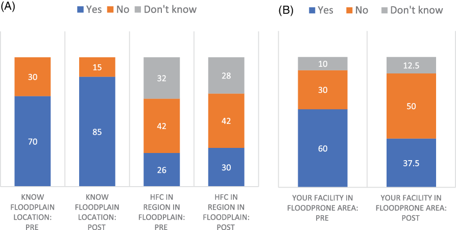
Figure 2 summarizes the knowledge of 2 groups of respondents: those who work for state, regional, or local agencies (such as health departments or emergency response agencies), and those who work for HCFs. The figure demonstrates that at baseline, nearly one-third of respondents who work at the state, region, county, or city/town agencies reported not knowing where floodplains are located in their respective area or whether HCFs in their area are located in floodplains, and 10% of hospital and long-term care facility respondents did not know if their facility was in a floodplain or flood-prone location. Knowledge about where floodplains are located and whether HFCs are in floodplains increased among respondents who work at the state, region, county, or city/town agencies from 70% before using the WBMFHF to 85% afterward.
Knowledge about HCFs and floodplains. (A) Knowledge of state, country, or local agency staff regarding their jurisdiction (n = 53 pre; 59 post). (B) Knowledge of hospital and long-term care facility regarding their facility (n = 10 pre; 8 post).

The 73 follow-up survey respondents noted several potential or intended uses for the mapping tool. These were to inform Hazard Vulnerability Analyses (49%), inform Multi-Hazard Mitigation Plans (41%), share with community partners (40%), identify HCFs near flood-prone rivers (37%), share with local HCFs (37%), inform evacuation plans (30%), educate residents about flood preparedness (23%), and share with zoning or planning commissions (7%). Only 11% of respondents indicated that they did not intend to use the WBMFHF.
Discussion
To generate a data-driven approach to plan for the safety of HCFs in flood events, the WBMFHF was developed, which allows users to visualize HCFs in relation to the 1996 100-y floodplains (1% annual risk of flooding) and 500-y floodplains (0.2% annual risk of flooding). The map identified 40 HCFs in 500- and 100-y floodplains. Once the interactive map was made available online, 73 survey respondents reported a variety of intended uses for this information source, including the development of local preparedness plans, communicating with stakeholders, and informing at-risk HCFs.
This research is subject to several limitations. The mapping tool is dependent on the accuracy and availability of floodplain data and location information about HCFs. Medical and dental practices were not included in the map. The number of respondents—104 at baseline and 73 at follow-up—is relatively small and a nonrandom sample of public health preparedness professionals and health-care administrators. The floodplain maps, although they are the most recently available, are based on 1996 data. Given the increase in heavy precipitation events in Illinois observed and projected, as well as changes in land use, a larger set of HCFs will likely be in floodplains in the coming decades; this is not reflected in the current WBMFHF. Finally, we did not ask respondents to provide their name or other personal identifiers. Thus, we reported differences in baseline and follow-up responses at the group level, rather than at the individual level. However, a subset of 17 respondents could be matched with relative confidence based on the job title, county name, employment level (state, region, county, city/town, hospital, or long-term care facility), and Internet provider address of the computer used when responding to the survey (any potential identifiers were kept confidential); the within-individual changes in survey responses before and after using the interactive map were comparable for this subset and for respondents overall.
Conclusions
Health-care facilities in Illinois—and likely elsewhere—are located in current floodplains. Considering the impacts of climate change on extreme precipitation events, web-based maps of local floodplains (present and projected) that identify locations of many types of HCFs will likely be useful for emergency preparedness planning by public health and preparedness organizations, as well as by administrators of health-care facilities, particularly for those without access to GIS expertise.
Acknowledgments
Many thanks to Prof. Sally McConkey of the Illinois State Water Survey for her assistance with floodplain data.
Author Contributions
Elena Grossman and Michelle Hathaway contributed equally as co-first authors.