During the late Pleistocene, Paleoindian foragers (13,500–11,400 cal BP) of eastern North America traversed dynamic landscapes during early migration pulses and subsequently established annual-seasonal mobility patterns (e.g., Anderson Reference Anderson1990, Reference Anderson, Nassaney and Sassaman1995; Anderson and Gillam Reference Anderson and Gillam2000; Anderson et al. Reference Anderson, Bissett, Yerka, Graf, Ketron and Waters2014, Reference Anderson, Smallwood and Miller2015; Ellis Reference Ellis2011; Ellis et al. Reference Ellis, Carr and Loebel2011; Kelly and Todd Reference Kelly and Todd1988; Meltzer Reference Meltzer, Barton, Clark, Yesner and Pearson2004, Reference Meltzer2009; Steele et al. Reference Steele, Adams and Sluckin1998; Surovell Reference Surovell2000). Embedded within this literature are studies that explore lithic procurement strategies, many through some iteration of least-cost path analysis (LCP) to identify potential toolstone acquisition routes (e.g., Boulanger et al. Reference Boulanger, Buchanan, O'Brien, Redmond, Glascock and Eren2015; Eren et al. Reference Eren, Chao, Chiu, Colwell, Buchanan, Boulanger, Darwent and O'Brien2016, Reference Eren, Miller, Buchanan, Boulanger, Bebber, Redmond, Stephens, Coates, Boser, Sponseller and Slicker2019; Lothrop et al. Reference Lothrop, Burke, Winchell-Sweeney and Gauthier2018; Miller et al. Reference Miller, Bebber, Rutkoski, Haythorn, Boulanger, Buchanan, Bush, Owen Lovejoy and Eren2019). Understanding the nature of such movements has significant implications for anthropological and archaeological theory (e.g., Anthony Reference Anthony1990, Reference Anthony, Chapman and Hamerow1997; Bruno et al. Reference Bruno, Lamb, Kaiwari, Cummings, Jordan and Zvelebil2014; Burmeister Reference Burmeister2000; Cabana and Clark Reference Cabana and Clark2011; van Dommelen Reference van Dommelen2014), particularly as it relates to regional variability in land-use behavior, culture change, subsistence strategies and prey choice, band territory development, demographic trends, technological organization, and cultural learning and transmission.
This article advances an explanatory model that evaluates potential travel corridors connecting a significant upper Ohio Valley Paleoindian site, Sandy Springs (33AD30; Purtill Reference Purtill2017; Seeman et al. Reference Seeman, Summers, Dowd, Morris and Dancey1994), to Upper Mercer–Vanport chert outcrops in central Ohio. To identify diverse components of the decision-making process, this model integrates elements of two theoretical perspectives: landscape learning (Golledge Reference Golledge, Rockman and Steele2003; Kelly Reference Kelly, Rockman and Steele2003; Meltzer Reference Meltzer and Jablonski2002, Reference Meltzer, Rockman and Steele2003, Reference Meltzer, Barton, Clark, Yesner and Pearson2004; Rockman Reference Rockman, Rockman and Steele2003, Reference Rockman, Prentiss, Kuijt and Chatters2009) and risk-sensitive analysis (e.g., Kahneman and Tversky Reference Kahneman and Tversky1979; Tversky and Kahneman Reference Tversky and Kahneman1992; Winterhalder Reference Winterhalder, Dunbar and Barrett2007; Winterhalder et al. Reference Winterhalder, Lu and Tucker1999). To compensate for limited landscape knowledge early in the Paleoindian occupation of southern Ohio, this model hypothesizes that Clovis foragers established an early route in the constricted, rugged Ohio Brush Creek–Baker's Fork (OBC-BF) drainage immediately adjacent to the high-relief escarpment of the Allegheny Plateaus. Throughout the Paleoindian Period, travel by the OBC-BF route continued despite the presence of the seemingly more energy-efficient alternative, the broader lower Scioto Valley (LSV). This study interprets the persistence of the OBC-BF route as reflecting the adoption of a risk-averse strategy to mitigate outcome variability resulting from the hydrologically stochastic LSV system, a condition that characterized most major eastern North American rivers during the late Pleistocene (e.g., Arbogast et al. Reference Arbogast, Bookout, Schrotenboer, Lansdale, Rust and Bato2008; Holliday and Miller Reference Holliday, Miller, Graf, Ketron and Waters2014:228–233; Knox Reference Knox, Gregory, Starkel and Baker1995). This study evaluates the proposed model through cross-temporal archaeological site patterning, assessment of geomorphologic processes for site preservation and visibility, and quantitative cost-benefit comparison of two hypothesized routes using an LCA geographic information systems (GIS) workflow. Finally, this study compares findings to current immigration and settling-in models of eastern North American Paleoindian societies.
Study Area and Geomorphic History
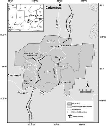
The study area includes the upper Ohio River drainage basin, specifically seven counties in south-central Ohio: Adams, Highlands, Jackson, Pike, Ross, Scioto, and Vinton (Figure 1). The Scioto River and Ohio Brush Creek watersheds, both tributaries of the Ohio River, principally drain the study area. The Scioto River is a substantial north-to-south trending drainage that extends from Auglaize County in central Ohio, 372 km south to its confluence with the Ohio River at Portsmouth. In its entirety, the Scioto Valley drains 16,878 km2 of land (Sherman Reference Sherman1999) and extends from the deglaciated, low-relief Till Plains of central Ohio to the unglaciated, high-relief Appalachian Plateaus of southern Ohio.
Location of the study area in southern Ohio showing Ohio Brush Creek–Baker's Fork (OBC-BF), middle Scioto Valley (MSV), and lower Scioto Valley (LSV) catchment basins. Location of Sandy Springs and Upper Mercer–Vanport chert outcrops also illustrated.

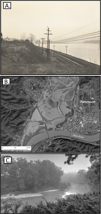
Within the current study area, the Scioto Valley includes 8,762 km2 of land that extends from just north of the Wisconsinan glacial margin near Chillicothe to its intersection with the Ohio River at Portsmouth. This study further divides the reach into middle and lower watersheds. The middle Scioto Valley (MSV) extends from just north of Chillicothe, 75 km downriver to Waverly. The lower reach, or LSV, flows 161 km between Waverly and the Ohio River at Portsmouth (Figure 1). The modern Scioto River is underfit and flows through a precut ancestral bedrock valley that ranges in width up to approximately 5.4 km (Kempton and Goldthwait Reference Kempton and Goldthwait1959). Modern average discharge for the Scioto at Piketon is 198 m3/s with reaches of the lower Scioto experiencing discharge as high as >15,000 m3/s during major floods (U.S. Geological Survey 2020; Webber and Bartlett Reference Webber and Bartlett1976:48; Figure 2).
Photographs of the lower Scioto River and Ohio Brush Creek. (a) Scioto River near Portsmouth during 1940 flood with discharge at approximately 10,400 m3/s (Portsmouth Public Library 2020). Note inundation of significant portions of valley bottom (~2.2 km in width), with railroad situated on the upper alluvial terrace as defined in this study; (b) Google Earth aerial image of lower Scioto River at its confluence with Ohio River showing significant inundation of valley bottom during moderate flooding (discharge at ~3700 m3/s) on March 4, 2017; (c) Modern view of Ohio Brush Creek approximately 10 km east of West Union, Ohio. Photo courtesy of Jim M. McCormac and used with permission.

MSV-LSV valley-bottom geomorphology is complex and consists of glacial outwash and alluvial terraces. During the Wisconsinan glaciation, meltwater pulses delivered significant glaciofluvial sediment loads that resulted in valley-floor aggradation and reworking of earlier Illinoian outwash. Significant outwash delivery to MSV-LSV ceased by roughly 14,000 cal BP, coincident with the northward retreat of the Scioto Sublobe out of the Scioto River's headwaters (Dyke et al. Reference Dyke, Moore and Robertson2003). Post-deposition erosion and lateral river migration resulted in discontinuous preservation of Illinoian (>130,000 cal BP) and Wisconsinan (22,000–14,000 cal BP) outwash terrace remnants that range in height from 13 to 46 m above the modern Scioto River. Importantly, current terrace geochronology is poorly established and largely based on soil weathering properties and topographic correlation to radiocarbon-dated moraines to the north.
Compared to the Scioto River, the OBC-BF is a significantly smaller regime that drains 1,117 km2 of land primarily in Adams and Highland Counties (Figure 1). With its headwaters just south of Bainbridge, Ohio, the drainage system flows 92 km south along the western edge of the Allegheny Plateaus escarpment in a high-relief section of the Outer Bluegrass Region. This karstic region contains common tallgrass prairie remnants of uncertain age (Braun Reference Braun1928). As measured near West Union, average modern OBC-BF discharge is 13 m3/s, more than an order of magnitude less than the Scioto River. This valley was primarily unglaciated except the northernmost headwaters of Baker's Fork system during the Illinoian (Pavey et al. Reference Pavey, Goldthwait, Scott Brockman, Hull, Mac Swinford and Van Horn1999; Rosengreen Reference Rosengreen1974). Unlike MSV-LSV, OBC-BF has narrow valley bottoms, typically less than 0.8 km in width. Illinoian outwash terrace remnants discontinuously line the valley bottom and rise 9–17 m above the modern river surface (Rosengreen Reference Rosengreen1974:23). DEM data inspected for this study reveal two undated alluvial surfaces, including an intermediate surface at 6–8 m and a low surface at 3–4 m above the modern river surface. As with the MSV-LSV, OBC-BF terraces remain poorly dated.
Archaeological Data and Distributions
Paleoindian Occupation of the Upper Ohio Valley
The upper Ohio Valley boasts a robust inventory of Paleoindian sites, especially those containing fluted bifaces (e.g., Buchanan Reference Buchanan2003; Prasciunas Reference Prasciunas2011; Prufer and Baby Reference Prufer and Baby1963; Seeman and Prufer Reference Seeman and Prufer1982). High densities led Anderson and colleagues to propose the Ohio Valley as an early staging area for eastern U.S. colonizing populations (e.g., Anderson Reference Anderson1990, Reference Anderson, Nassaney and Sassaman1995, Reference Anderson, Anderson and Sassaman1996; Anderson and Faught Reference Anderson and Faught2000; Eren et al. Reference Eren, Chao, Chiu, Colwell, Buchanan, Boulanger, Darwent and O'Brien2016). One of the largest Paleoindian occupations in the unglaciated upper Ohio Valley is Sandy Springs (33AD30; Cunningham Reference Cunningham1973; Purtill Reference Purtill2017; Seeman et al. Reference Seeman, Summers, Dowd, Morris and Dancey1994). Known primarily from amateur collections, the surface site reflects a thin scatter of material over 40+ ha of agricultural fields on middle- to upper-alluvial/outwash terraces of the Ohio River that are characterized by dune and loess deposition (Purtill Reference Purtill2017). Although undated by radiometric means, the recovery of over 100 diagnostic bifaces classified as Clovis or Gainey, Cumberland, Beaver Lake, Agate Basin, and additional lanceolate forms (Seeman et al. Reference Seeman, Summers, Dowd, Morris and Dancey1994) indicates repeated occupation during the entire Paleoinidan Period. Early Paleoindian toolstone procurement at Sandy Springs mirrors regional trends with strong preference for Upper Mercer chert (Miller et al. Reference Miller, Bebber, Rutkoski, Haythorn, Boulanger, Buchanan, Bush, Owen Lovejoy and Eren2019; Prufer and Baby Reference Prufer and Baby1963; Seeman and Prufer Reference Seeman and Prufer1982; Seeman et al. Reference Seeman, Summers, Dowd, Morris and Dancey1994; Tankersley et al. Reference Tankersley, Smith and Cochran1990) from east-central Ohio (Carlson Reference Carlson1991; Stout and Schoenlaub Reference Stout and Schoenlaub1945). At Sandy Springs, Upper Mercer accounts for 69% of the Clovis-Gainey assemblage (n = 9), although nonlocal materials include Hixton Silicified Sandstone (HSS; n = 1), which outcrops approximately 890 km to the northwest in Wisconsin (Carr and Boszhardt Reference Carr and Boszhardt2010) and Paoli chert (n = 2), which outcrops about 20 km to the southeast in Kentucky (Vickery Reference Vickery and N'omi1983). Collectively, toolstone exploitation suggest multiregional interaction at Sandy Springs (Seeman et al. Reference Seeman, Summers, Dowd, Morris and Dancey1994) with increased southern interaction through time as revealed through the recovery of post-Clovis Cumberland bifaces (n = 15), many manufactured from Kentucky Paoli chert (Seeman et al. Reference Seeman, Summers, Dowd, Morris and Dancey1994; Tune Reference Tune2016a, Reference Tune2016b).
Paleoindian research indicates strong latitudinal, perhaps seasonal, mobility in deglaciated landscapes (e.g., Boulanger et al. Reference Boulanger, Buchanan, O'Brien, Redmond, Glascock and Eren2015; Ellis Reference Ellis2011; Redmond and Tankersley Reference Redmond and Tankersley2005; Simons Reference Simons, Jackson and Thacker1997), although this pattern is ambiguous in unglaciated southern clines where range mobility appears restricted (e.g., Anderson et al. Reference Anderson, Smallwood and Miller2015; Broster et al. Reference Broster, Norton, Shane Miller, Tune, Baker and Gingerich2013; Parish Reference Parish2018). A natural ford of the Ohio River at Sandy Springs may have facilitated river crossing, both by humans and potential prey (Seeman et al. Reference Seeman, Summers, Dowd, Morris and Dancey1994), making the site an attractive waypoint for any north-to-south movement. Latitudinal movements likely included travel along the high-relief escarpment zone of the Cumberland Plateau and Allegheny Plateaus that connects the unglaciated Southeast to deglaciated Midwest (Purtill Reference Purtill2017; Seeman et al. Reference Seeman, Summers, Dowd, Morris and Dancey1994). Given Sandy Springs's dense artifact collection, significant portions of the upper Ohio Valley Paleoindian population commonly moved through Sandy Springs as part of seasonal or annual rounds. Site inhabitants likely traveled north to Upper Mercer–Vanport chert outcrops to retool; strengthen social relations and learning opportunities; and facilitate the exchange of goods, ideas, and mates (Anderson Reference Anderson1990, Reference Anderson, Nassaney and Sassaman1995; Eren et al. Reference Eren, Buchanan and O'Brien2015, Reference Eren, Miller, Buchanan, Boulanger, Bebber, Redmond, Stephens, Coates, Boser, Sponseller and Slicker2019; Lepper Reference Lepper, Bonnischesen and Turnmire2005; Meltzer Reference Meltzer, Barton, Clark, Yesner and Pearson2004; Miller et al. Reference Miller, Bebber, Rutkoski, Haythorn, Boulanger, Buchanan, Bush, Owen Lovejoy and Eren2019).
Paleoindian and Archaic Site Distributions
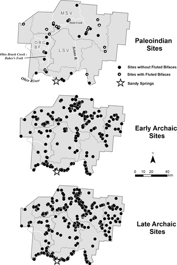
To provide a proxy for valley demography and/or intensity of travel, Paleoindian (n = 50), Early Archaic (n = 292; 11,400–8450 cal BP), and Late Archaic (n = 468; 5950–2650 cal BP; Purtill Reference Purtill, Emerson, McElrath and Fortier2009) sites are plotted for the study area (Figure 3). Site locations and cultural affiliations derive from Ohio Archaeological Inventory (OAI) forms maintained by the Ohio Historic Preservation Office. Prior to analysis, the author reviewed artifact inventories from OAI forms with Paleoindian components and relevant publications (e.g., Prufer and Baby Reference Prufer and Baby1963; Seeman and Prufer Reference Seeman and Prufer1982). This study excludes components with dubious Paleoindian affiliation as determined during review. This study does not conduct similar reviews of Early and Late Archaic components given the database’s size (n = 760) and limited potential that vetting would significantly alter overall trends.
Distribution of Paleoindian (n = 50), Early Archaic (n = 292), and Late Archaic (n = 468) sites recorded on OAI forms maintained by the Ohio Historic Preservation Office.

To mitigate potential effects of collector or taphonomic bias widely cited in Paleoindian studies (e.g., Anderson and Faught Reference Anderson and Faught2000:509; Buchanan Reference Buchanan2003; Loebel Reference Loebel2012; Shott Reference Shott2002, Reference Shott2004), this study employs a cross-temporal approach that uses the presence of Early and Late Archaic components to asses potential impacts of collector or taphonomic bias in areas characterized by an absence of Paleoindian material. This approach assumes that at every Early or Late Archaic find spot, there should be a near-equal chance for recovery of Paleoindian material, if present, even considering some bias. Although the assumption of progressive removal of older sites from the archaeological record is reasonable, studies (e.g., Bluhm and Surovell Reference Bluhm and Surovell2019; Surovell et al. Reference Surovell, Finley, Smith, Jeffrey Brantingham and Kelly2009; Williams Reference Williams2012), suggest that the rate of taphonomic site loss is not constant through time. Instead, it decreases through time primarily due to the protective agents of site burial (Surovell et al. Reference Surovell, Finley, Smith, Jeffrey Brantingham and Kelly2009:1718).
To control for potential collector and taphonomic bias, this study applies Surovell and colleagues’ (Reference Surovell, Finley, Smith, Jeffrey Brantingham and Kelly2009) nonlinear regression taphonomic correction model to determine expected site survival rates for Paleoindian, Early Archaic, and Late Archaic assemblages based on period age. Although the taphonomic correction model is typically applied to radiocarbon inventories, this study employs it to predict the expected frequency of sites in southern Ohio's archaeological record. To accomplish this, this study mimics Surovell and colleagues’ (Reference Surovell, Finley, Smith, Jeffrey Brantingham and Kelly2009:1717–1718) example by modeling the survival rate of 10,000 hypothetical sites produced at the midpoint year of each temporal period under consideration (Table 1). The taphonomic correction model regression equation is

where n t = predicted number of geologic contexts from time t, and t = temporal period midpoint.
Results of the Taphonomic Correction Model for Predicted Site Survival Rates in the Project Area.

a k is a constant (77.682) derived by Surovell et al. (Reference Surovell, Finley, Smith, Jeffrey Brantingham and Kelly2009:1717) to force the model to intersect the y-axis (time zero) at 10,000 sites.
Results from the taphonomic correction model predict that Early Archaic sites should have only a 2% higher survival rate than Paleoindian sites, whereas Late Archaic sites should have a 15% higher survival rate (Table 1). Given the negligible interperiod differences, taphonomic or sampling bias fails to fully explain the absence of Paleoindian material at locations of documented Early Archaic, and to a lesser degree, Late Archaic sites. Instead, this study interprets the absence of Paleoindian material at these locations as the result of deliberate avoidance behavior. Accordingly, relative interperiod site densities illustrate chronological shifts in land-use behavior between Paleoindian and Archaic populations. Similar comparative approaches have proven successful in previous studies (e.g., Jennings Reference Jennings, Smallwood and Jennings2015; Miller and Carmody Reference Miller and Carmody2016; Purtill Reference Purtill, Emerson, McElrath and Fortier2009).
Spatial and temporal variation in site patterning is apparent in the dataset, especially with relative densities between the three major watersheds considered in this study: OBC-BF, MSV, and LSV (Fisher's exact test = 19.851, p < 0.000Footnote 1; Table 2). Results indicate a significant overrepresentation of Paleoindian sites in the OBC-BF valley (standardized residual score +2.8; p < 0.01), concomitant with a complete lack of Paleoindian sites in LSV (standardized residual score −2.0; p < 0.05). In fact, review of all test standardized residual scores indicates that overall strength of association for the test derives from these two trends alone given that no other cells in Table 2 produce residuals beyond the critical value of 0.05 (standardized residual scores >1.96).
Distribution of Sites by Temporal Period and by Catchment Basin.

Note: Fisher's Exact Test = 19.851, p < 0.000; residual scores in [ ].
The most striking pattern is the absence of Paleoindian sites in the LSV coupled with higher-than-expected site densities in the OBC-BF valley. A parsimonious explanation for the absence of valley-bottom sites in LSV is that it reflects poor site preservation or limited archaeological visibility, not deliberate underutilization. This possible explanation assumes that Paleoindian travel did occur in LSV but that archaeological evidence has subsequently eroded or remains undiscovered in the valley. Although limited geochronological control exists for LSV, evidence provided below suggests that Paleoindian site absence in the LSV reflects deliberate underutilization of the basin and not preservation bias.
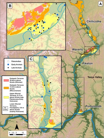
To help evaluate this proposal, this study incorporates 30 m resolution DEM data to map valley-bottom landforms in the project area (Figure 4). Review of relevant Quaternary geological and pedological literature and maps supplemented topographic information (e.g., Erber et al. Reference Erber, Spahr and Martin2016; Kempton and Goldthwait Reference Kempton and Goldthwait1959; Pavey et al. Reference Pavey, Goldthwait, Scott Brockman, Hull, Mac Swinford and Van Horn1999) to classify and correlate geomorphic surfaces across the valley. Outwash terrace remnants attributed to the Illinoian (>130,000 cal BP) range from 30 to 46 m above the modern river surface. In contrast, remnants attributed to the Wisconsinan (22,000–14,000 cal BP) rise 13–30 m (Pavey et al. Reference Pavey, Goldthwait, Scott Brockman, Hull, Mac Swinford and Van Horn1999) above the modern river surface. DEM data also reveal a flight of alluvial terraces/floodplains between 0 and 13 m above the modern river surface that should date to <14,000 cal BP. This study defines an upper alluvial terrace, 6–13 m in height, and a lower alluvial terrace, <6 m in height. Despite limited geochronological control, the distribution of Paleoindian and Early Archaic sites on upper alluvial surfaces, and to a lesser degree on some lower alluvial terraces, suggests that these landforms were available for Paleoindian travel/utilization during the late Pleistocene (Table 3). Although substantial erosion in LSV is evident, this study suggests that at least 14% of modern LSV bottomland is sufficiently old to contain Paleoindian material, if it exists (see Figure 4).
Frequency Distribution of Paleoindian and Early Archaic Sites by Landform Type in MSV-LSV.

Geomorphic surfaces of the MSV-LSV and distribution of Paleoindian and Archaic archaeological sites: (a) planview of MSV-LSV showing Illinoian (>130,000 cal BP) and Wisconsinan (~22,000–14,000 cal BP) outwash terraces and upper to lower alluvial terraces of late Pleistocene–Early Holocene age (<14,000 cal BP). Insets (b) and (c) provide examples of site distributions.

Although fluvial erosional processes potentially explain Paleoindian site absence in the LSV valley bottoms, the absence of sites from surrounding tributary valleys and uplands is more difficult to explain using a preservation bias argument. In fact, Paleoindian sites are absent from the entire 17,866 km2 LSV watershed, not just the 122 km2 (<1% of watershed) Scioto River bottomlands where erosion was prominent (see Figure 4). If Paleoindians explored or utilized the valley to any significant degree, some archaeological evidence should exist in the watershed. In fact, in other studies of deglaciated valleys where lateral erosion rates during the Holocene project to be similar to LSV (e.g., White River, Indiana [Herrmann Reference Herrmann2013; Herrmann and Monaghan Reference Herrmann and Monaghan2019]), the surfaces of “protected” valley-margin landforms and tributary mouths commonly yield some evidence of Paleoindian occupation. It is noteworthy that, despite the lack of Paleoindian utilization, Early Archaic sites occur along valley-margin landforms and tributary valleys in the LSV watershed. Because documented Paleoindian sites occur in secondary tributary valleys in both the MSV and OBC-BF basins, their absence in LSV fails to suggest deliberate avoidance of secondary drainages in southern Ohio. Finally, the simple fact that archaeological evidence supports rather intensive Paleoindian use of the OBC-BF route provides a plausible alternative for any need for travel through LSV. In fact, the Ohio River drainage proper has no recorded fluted bifaces between Sandy Springs and the mouth of the Scioto River (see Figure 3), suggesting eastward movement toward this drainage only later (post-Clovis) in time.
The lack of evidence for Paleoindian utilization of LSV is curious because, based on topography and route distance, the LSV route appears to be a logical travel corridor connecting Sandy Springs to Upper Mercer–Vanport outcrops. Historically, the Scioto Valley was a well-established route for Native Americans traveling between central Kentucky, where it was part of the “Warrior's Path,” and northern Ohio (Mills Reference Mills1914). Hypothesized travel through LSV also matches expectations of proposed Paleoindian land-use behaviors, including a desire to minimize travel through the rugged terrain of the Appalachian Plateaus (e.g., Anderson and Faught Reference Anderson and Faught1998:175; Lane and Anderson Reference Lane, Anderson, Sullivan and Prezzano2001; Meltzer Reference Meltzer1985; Prufer and Baby Reference Prufer and Baby1963:62–63; Seeman and Prufer Reference Seeman and Prufer1982) and a preference to utilize major river valleys (e.g., Anderson Reference Anderson, Nassaney and Sassaman1995:13–15; Anderson and Faught Reference Anderson and Faught2000; Anderson and Gillam Reference Anderson and Gillam2000; Tune Reference Tune2016b). In addition to human travel, it is likely that the Scioto Valley was a preferred migration route for herd animals commonly targeted by eastern-U.S. Paleoindians, such as caribou and bison (e.g., Gingerich and Kitchel Reference Gingerich, Kitchel, Smallwood and Jennings2015). For these reasons, the LSV route appears optimal for travel by Paleoindian groups. Archaeological evidence, however, fails to support use of this corridor. Instead, evidence supports travel through the less-optimal OBC-BF valley, with its comparatively steeper terrain and constricted valleys. To better quantify the cost in travel hours between each route, the following section provides the results of a least-cost analysis (LCA).
Least-Cost Analysis
Least-cost analysis (LCA) is a common method to reveal early forager migration travel and resource-acquisition routes in the Americas (e.g., Anderson and Gillam Reference Anderson and Gillam2000; Boulanger et al. Reference Boulanger, Buchanan, O'Brien, Redmond, Glascock and Eren2015; Eren et al. Reference Eren, Chao, Chiu, Colwell, Buchanan, Boulanger, Darwent and O'Brien2016, Reference Eren, Miller, Buchanan, Boulanger, Bebber, Redmond, Stephens, Coates, Boser, Sponseller and Slicker2019; Gustas and Supernant Reference Gustas and Supernant2019; Krist and Brown Reference Krist and Brown1994; Lothrop et al. Reference Lothrop, Burke, Winchell-Sweeney and Gauthier2018; Rademaker et al. Reference Rademaker, Reid, Bromley, White and Surface-Evans2012). Most traditional LCA studies in archaeology assume that human actors employ consistent decision-making behavior, possess complete environmental knowledge, and search for the most cost-effective—or optimized—route based on environmental factors of distance and topographic relief (Herzog Reference Herzog, Bevan and Lake2013; Surface-Evans and White Reference Surface-Evans, White, White and Surface-Evans2012:2; White Reference White2015:407–408). Although some suggest that eastern-U.S. Paleoindians prioritized time optimization during seasonal trips (e.g., Lothrop et al. Reference Lothrop, Burke, Winchell-Sweeney and Gauthier2018:75), ethnographic data on forager decision making does not fully support this proposition (Kelly Reference Kelly2013:33–36). Non-optimal satisficing principles, or bounded rationality, often guide forager decisions, including selection of the first option that surpasses some acceptable threshold (e.g., Golledge Reference Golledge, Rockman and Steele2003; Morgan Reference Morgan2015; Simon Reference Simon1956). As Golledge notes, “Wayfinders are often satisfied with the act of reaching a destination while paying little heed to how effective or efficient they have been in pursuing the wayfinding task” (Reference Golledge, Rockman and Steele2003:25). This observation provides pause for studies that assume, a priori, rational optimality when interpreting LCA travel routes, especially when done in the absence of archaeological support. This study considers the results of the LCA as a null hypothesis tested against archaeological evidence to evaluate potential travel routes.
With this caution in mind, this study employs LCA to quantify the travel effort, measured in hours, to traverse the OBC-BF and LSV routes connecting Sandy Springs to Upper Mercer–Vanport outcrop areas. This represents a straight-line distance of approximately 180 km. LCA workflow for this study replicates White's (Reference White2015) workflow and includes the creation of friction and cumulative cost raster surfaces derived from DEM (30 m resolution) and degree-slope raster files. This study uses the Mean Center tool in ArcMap 10.5 to create a single node that reflects the geometric mean of the Upper Mercer and Vanport outcrop areas to facilitate LCA creation. The Mean Center approach is necessary because, aside from the Welling site (Miller et al. Reference Miller, Bebber, Rutkoski, Haythorn, Boulanger, Buchanan, Bush, Owen Lovejoy and Eren2019; Prufer and Wright Reference Prufer and Wright1970), specific Paleoindian quarries are unknown as Upper Mercer and Vanport chert outcrop broadly over 2,700 km2 of land (Carlson Reference Carlson1991; Stout and Schoenlaub Reference Stout and Schoenlaub1945).
Because more sophisticated LCA workflows that model additional environmental and social “costs” of travel (e.g., Güimil-Fariña and Parcero-Oubiña Reference Güimil-Fariña and Parcero-Oubiña2015; Gustas and Supernant Reference Gustas and Supernant2019; Livingood Reference Livingood, White and Surface-Evans2012) are not utilized, LSV and OBC-BF routes constructed here are considered the minimal effort required to travel on foot between locations. Following White (Reference White2015:409), this workflow employs a modified version of Tobler's hiking function (Tobler Reference Tobler1993) that quantifies travel by determining the number of hours required for an individual to traverse the distance of each grid cell (or 30 m in this case). Below is the formula to calculate time:

T = travel time (hours)
R = DEM spatial resolution (30 m in this case)
D = slope in degrees
LCA Results
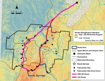
The first step in LCA is to determine if the optimal route between Sandy Springs and Upper Mercer–Vanport outcrops involves travel through LSV, as originally hypothesized. Unsurprisingly, LCA results indicate that the LSV route is the optimal route path connecting the two locations (Figure 5). Using Sandy Springs as a starting point, the generated LSV route proceeds east along the Ohio River, enters the LSV at its mouth, and moves north through MSV until just south of Chillicothe, where it enters several smaller tributaries skirting parts of the Wisconsinan glacial boundary. The LSV route is 209 km long with a mean slope of 1.3° and a maximum slope angle of 15°. LCA estimates a total of 46 hours of travel time between Sandy Springs and Upper Mercer–Vanport chert outcrops.
Results of LCA analysis showing the creation of two potential travel routes, LSV and OBC-BF, connecting the Sandy Springs site to Upper Mercer–Vanport chert outcrops. Travel routes set against a terrain roughness map were generated utilizing Riley and colleagues’ (Reference Riley, DeGloria and Elliot1999) Terrain Roughness Indicator formula. Please note that archaeological site distributions are only mapped for study area.

Although LCA indicates an optimal travel corridor, LSV route use is unsupported with current OAI data. Instead, archaeological data suggest travel through the more rugged OBC-BF valley via a longer route path. To quantify the costs associated with this alternative route, this study created a second LCA route through the OBC-BF valley by using the Mask tool in ArcMap 10.5 to block potential travel through LSV (Figure 5). The generated OBC-BF route proceeds from Sandy Springs west up the Ohio River until it enters Ohio Brush Creek at its mouth, moves north to northeast into the Baker's Fork drainage, and then into the Paint Creek valley of the MSV watershed before entering the deglaciated landscape just north of Chillicothe. The final OBC-BF route is 234 km long, with a mean slope of 1.7° and a maximum slope angle of 32°. Through extraction of travel costs from the friction raster, LCA estimates a total of 54 hours of travel time for the OBC-BF route. Given these values, the OBC-BF route reflects a 17% increase in travel time over the LSV route and traverses generally steeper terrain. From an energy and time allocation perspective, the OBC-BF route is not optimal for travel, yet it closely matches the known distribution of Paleoindian sites.
Modeling Distribution Data with Landscape Learning and Risk-Sensitive Analysis
This study now explores Paleoindian site patterning in southern Ohio from two theoretical perspectives: landscape learning and risk-sensitive analysis. This plurality allows for development of an explanatory model that integrates cultural, historical, and evolutionary elements while analyzing decision making for late Pleistocene foragers. Some may question the application of landscape learning theory for a Paleoindian dataset under the premise that there is little chance of observing truly colonizing behavior due to low fertility rates and low archaeological visibility of initial migrants (cf. Surovell Reference Surovell2000). Although this may be true to some degree, it is argued that the warm-cold paleoclimatic oscillations associated with the Bølling-Allerød to Younger Dryas to Holocene created dynamic late Pleistocene environmental/climate patterns with responding hydrological/geomorphological evolutions (e.g., Holliday and Miller Reference Holliday, Miller, Graf, Ketron and Waters2014; Knox Reference Knox, Gregory, Starkel and Baker1995; Meltzer and Holliday Reference Meltzer and Holliday2010; Shane Reference Shane and Dancey1994; Yu Reference Yu2000; Yu and Eicher Reference Yu and Eicher2001). This dynamism undoubtedly complicated—and lengthened—attempts at landscape learning by early foragers in southern Ohio beyond the initial colonizing event. This especially is true when obtaining limitational environmental knowledge (Rockman Reference Rockman, Rockman and Steele2003, Reference Rockman, Prentiss, Kuijt and Chatters2009), defined as long-term cyclical trends such as flood recurrence intervals or seasonal precipitation patterns. As Rockman illustrates (Reference Rockman, Rockman and Steele2003:5), it takes generations to acquire limitational knowledge, perhaps longer on recently deglaciated landscapes similar to LSV (e.g., Loyola et al. Reference Loyola, Núñez and Cartajena2019; Tolan-Smith Reference Tolan-Smith, Rockman and Steele2003). Under these conditions, it is expected that landscape learning continued throughout the Paleoindian period.
The presence of sites containing fluted bifaces paralleling the Allegheny Plateaus escarpment in the OBC-BF valley indicates route establishment during the early Paleoindian period, specifically Clovis. Although most acknowledge a pre-Clovis population in the Americas, most also view Clovis as a population that migrated into a largely unoccupied, poorly understood terrain (e.g., Meltzer Reference Meltzer2009). Adjacency to the visible escarpment accords well with predictions of landscape learning theory for wayfinding groups possessing incomplete environmental knowledge (Rockman Reference Rockman, Rockman and Steele2003, Reference Rockman, Prentiss, Kuijt and Chatters2009), notably the use of easily legible geographies for travel such as river valleys, linear mountain ranges, and escarpments (e.g., Golledge Reference Golledge, Rockman and Steele2003; Kelly Reference Kelly, Rockman and Steele2003; Kelly and Todd Reference Kelly and Todd1988; Meltzer Reference Meltzer, Rockman and Steele2003:226–229, Reference Meltzer, Barton, Clark, Yesner and Pearson2004:133; Reference Meltzer2009:223). For foragers exploring dynamic and evolving landscapes, decisions to establish early trail systems likely involved settings that increased trail visibility and ease of relocation, rather than ones that simply increased travel efficiency (e.g., Anderson Reference Anderson, White and Surface-Evans2012:242; Golledge Reference Golledge, Rockman and Steele2003:25; Rademaker et al. Reference Rademaker, Reid, Bromley, White and Surface-Evans2012:34). Furthermore, the OBC-BF route may have been part of a previously reported early travel corridor connecting the unglaciated Cumberland, Ohio, and Tennessee drainages (Purtill Reference Purtill2017:171; Seeman and Prufer Reference Seeman and Prufer1982:157–158) to northern deglaciated landscapes along the combined escarpment system of the Cumberland Plateau and Alleghany Plateaus.
A second potential reason for the initial establishment of the OBC-BF travel route is that it represented “familiar” territory given its location in the karstic, prairie-rich Bluegrass section of the Interior Low Plateau Province (Braun Reference Braun1928; Brockman Reference Brockman2006; Fenneman Reference Fenneman1928). The OBC-BF watershed represents the northernmost extension of the Interior Low Plateau, with the escarpment zone of the Cumberland Plateau and Allegheny Plateaus accounting for the eastern edge of this province. Proximity to physiographic boundaries is a documented pattern for eastern-U.S. Paleoindian sites given that populations likely exploited edge habitats (Miller Reference Miller2016:710; Tune Reference Tune2016b:310). To the south, the Interior Low Plateau includes the Tennessee and Cumberland drainages, a region rich in Paleoindian material (e.g., Anderson Reference Anderson1990, Reference Anderson, Nassaney and Sassaman1995, Reference Anderson, Anderson and Sassaman1996; Anderson et al. Reference Anderson, Smallwood and Miller2015; Broster et al. Reference Broster, Norton, Shane Miller, Tune, Baker and Gingerich2013; Miller and Carmody Reference Miller and Carmody2016; Tune Reference Tune2016a). By contrast, limited evidence exists of Paleoindian utilization of the Appalachian Plateaus that contains LSV (e.g., Anderson and Faught Reference Anderson and Faught1998:175; Lane and Anderson Reference Lane, Anderson, Sullivan and Prezzano2001; Prufer and Baby Reference Prufer and Baby1963:62–63; Seeman and Prufer Reference Seeman and Prufer1982).
It is likely that Paleoindians traveling north into the Ohio Valley initially favored the Bluegrass section due to its environmental similarities with southern settings. In this sense, Paleoindians may simply have expanded home ranges within homogenous ecological macroenvironments, thereby facilitating the transfer of accumulated environmental knowledge to new landscapes. Other studies of late Pleistocene foragers in the Americas suggest similar exploration and colonization of homogenous landscapes (e.g., Johnson et al. Reference Johnson, Politis, Gutíerrrez, Martínez, Miotti, Morrow and Gnecco2006; Loyola et al. Reference Loyola, Núñez and Cartajena2019; Meltzer Reference Meltzer, Barton, Clark, Yesner and Pearson2004; Osorio et al. Reference Osorio, Steele, Sepulveda, Gayo, Capriles, Katherine, Ugalde, De Pol-Holz, Latorre and Santoro2017). Although initial OBC-BF route establishment may be due to the highly legible escarpment landscape, this fails to explain why Paleoindians never adopted the optimal LSV route once they learned of the valley's existence. Foragers assuredly encountered LSV early in their seasonal and annual movements, and it is likely that they actively explored valley margins during scouting or hunting forays (Meltzer Reference Meltzer and Jablonski2002, Reference Meltzer, Barton, Clark, Yesner and Pearson2004).
Although various reasons could account for a deliberate avoidance of LSV by Paleoindians, many of which are untestable with archaeological evidence, this study proposes that such behavior represents the adoption of risk-averse behavior by early foragers facing a stochastic environment. Risk-averse individuals avoid “behaviors linked to unpredictable outcomes in favor of more certain ones” (Winterhalder et al. Reference Winterhalder, Lu and Tucker1999:303), which relates to optimal foraging theory, behavioral ecology and economics, and human cognition studies. Risk-averse theory in anthropological studies defines gains or losses from the perspective of fitness (survival and reproduction) and utility (efficient energy expenditure and time allocation; e.g., Winterhalder Reference Winterhalder1986, Reference Winterhalder, Dunbar and Barrett2007). Referred to as the “certainty effect” in prospect theory (e.g., Kahneman and Tversky Reference Kahneman and Tversky1979:262; see also Tversky and Kahneman Reference Tversky and Kahneman1992), behavioral and cognitive studies demonstrate that risk-averse individuals avoid probabilistically ambiguous outcomes even when such outcomes have higher probability of gain compared to more constant ones (e.g., Mukherjee et al. Reference Mukherjee, Sahay, Chandrasekhar Pammi and Srinivasan2017; Rode et al. Reference Rode, Cosmides, Hell and Tooby1999; Sharp et al. Reference Sharp, Viswanathan, Lanyon and Barton2012). Finally, cognitive and behavioral studies reveal that humans consistently overestimate the probability of catastrophic, or low-probability, events (e.g., Armantier Reference Armantier2006; Kahneman and Tversky Reference Kahneman and Tversky1979; Taleb Reference Taleb2010). This implies that experience with rare events—for example, catastrophic floods—significantly influences how individuals weigh potential choices in the decision-making process.
Large rivers such as the Scioto had higher, more variable discharges during the late Pleistocene when compared to modern flow regimes (e.g., Arbogast et al. Reference Arbogast, Bookout, Schrotenboer, Lansdale, Rust and Bato2008; Holliday and Miller Reference Holliday, Miller, Graf, Ketron and Waters2014:228–233; Knox Reference Knox, Gregory, Starkel and Baker1995). The potential for catastrophic floods increases with higher discharges, notably downstream. Even today, modern floods often inundate significant portions of the valley bottom, especially near LSV's confluence with the Ohio River (see Figure 2a–b). In alignment with risk-aversion behavior, the mere memory of past flood events may have heightened subjective uncertainty among Paleoindians, even if actual probabilities of high-magnitude flooding in LSV remained low annually.
During the late Pleistocene, the Scioto River likely fluctuated between unstable braided and single-thread river planforms. Such fluctuations occur in response to episodic increases in sediment load, including occasional release of stored glaciofluvial sediments during high-magnitude floods or extreme paleoclimate events (e.g., Younger Dryas Chronozone; Knox Reference Knox, Gregory, Starkel and Baker1995:94). During braided stages, rivers have variable discharges, and they are transitory, with complete reworking of geomorphic units within a matter of years (e.g., Ashmore Reference Ashmore1991; Malard et al. Reference Malard, Uehlinger, Zah and Tockner2006; van der Nat et al. Reference van der Nat, Tockner, Edwards, Ward and Gurnell2003). For example, van der Nat and colleagues (Reference van der Nat, Tockner, Edwards, Ward and Gurnell2003) report that approximately 60% of the aquatic area and approximately 30% of vegetated channel bars on the Tagliamento River (Italy) experienced complete restructuring in just 2.5 years. The transitory nature of in-channel geomorphic units in the LSV during braided stages would hamper travel attempts as trail systems became impassable or destroyed. Minimally, constant trail reestablishment would increase travel outcome variability, especially for recently deglaciated landscapes such as LSV (e.g., Loyola et al. Reference Loyola, Núñez and Cartajena2019; Tolan-Smith Reference Tolan-Smith, Rockman and Steele2003). Probability overweighting in such settings may have been exacerbated under instances of high residential mobility (e.g., Goodyear Reference Goodyear, Ellis and Lothrop1989; cf. Meltzer Reference Meltzer, Barton, Clark, Yesner and Pearson2004) as vulnerable group members such as the very young and very old were prone to injury or death due the stochastic environment.
In addition to travel outcome uncertainty, the late Pleistocene LSV also may have been generally inhospitable to humans, and perhaps even to migrating animal herds, due to environmental degradation and habitat fragmentation that accompanies sudden increases in sediment load. The presence of sandy loess sediments on adjacent, easterly alluvial surfaces and uplands in the valley (Rutledge et al. Reference Rutledge, Holowychuk, Hall and Wilding1975) suggests eolian deflation of newly created braid bars and alluvial plains. Although undated in the Scioto Valley, sandy loess deposition on high alluvial surfaces at Sandy Springs date to the late Pleistocene–early Holocene (Purtill et al. Reference Purtill, Steven Kite and Forman2019). Contemporary eolian deflation and subsequent transport likely occurred in the Scioto Valley, perhaps increasing air dustiness and deposition of fine sediment in rivers. Elevated dustiness increases health issues related to respiratory functions (Karanasiou et al. Reference Karanasiou, Moreno, Moreno, Viana, de Leeuw and Querol2012; Mitsakou et al. Reference Mitsakou, Kallos, Papantoniou, Spyrou, Solomos, Astitha and Housiadas2008). Excessive fine sediment in rivers decreases water quality through increases in salinization due to the dissolution of solids.
In contrast to LSV, the more geomorphically stable OBC-BF valley would facilitate acquisition of landscape knowledge and reduce travel outcome variability, although at the expense of higher energy expenditure due to the longer path route. Given its single-thread planform and low volume of stored glacial outwash, OBC-BF likely possessed fewer in-channel physical obstacles than LSV, such as transitory gravel bars or islands. LCA results indicate that under optimal conditions without significant delays, foragers would expect a 17% decrease in utility—that is, increase in travel time—for travel along the OBC-BF route in lieu of the LSV route. It is interesting to note that in their study of decision-making under risk, Sharp and colleagues found that most participants followed the certainty effect except in situations where “the less likely proposition had an expected value of 38% or more than that of the safer prospect” (Reference Sharp, Viswanathan, Lanyon and Barton2012:6). This suggests that even with risk-averse behavior, individuals may select choices of high outcome uncertainty but only when the expected value—or reward—crosses a specific threshold. For Paleoindians in southern Ohio, this study suggests that any potential gains for travel through LSV failed to offset the more certain travel outcomes associated with the OBC-BF route.
Discussion and Conclusions
This study interprets the avoidance of LSV as an adoption of a risk-averse strategy to limit outcome variability during travel by Paleoindians operating in the upper Ohio River Valley. The preference for travel through the longer OBC-BF route rather than the shorter, more optimal LSV route has several implications concerning Paleoindian land-use behavior in eastern North America. This study suggests that factors embedded in landscape learning and risk-aversion theories motivated decisions concerning trail placement and continued use in the seemingly less efficient OBC-BF valley. Intensive use of a smaller, more constricted valleys such as OBC-BF contrasts with many cited Paleoindian land-use behaviors, including a preference to utilize major river valleys and avoid rugged terrain (e.g., Anderson and Faught Reference Anderson and Faught2000; Anderson and Gillam Reference Anderson and Gillam2000; Lane and Anderson Reference Lane, Anderson, Sullivan and Prezzano2001; Seeman and Prufer Reference Seeman and Prufer1982; Tune Reference Tune2016b). Although current evidence for Paleoindian exploitation of LSV is absent, this study does not suggest that early foragers entirely avoided, or were unaware of, the “road not taken.” It is likely that at least some valley exploration and accumulation of environmental knowledge occurred in LSV during the late Pleistocene. Current evidence, however, clearly indicates intensive utilization of the OBC-BF valley in lieu of the LSV. Future research should document the exact role site preservation or visibility plays in modern site-distribution patterns for the study area.
Recently, Miller and colleagues (Reference Miller, Bebber, Rutkoski, Haythorn, Boulanger, Buchanan, Bush, Owen Lovejoy and Eren2019) and Eren and colleagues (Reference Eren, Miller, Buchanan, Boulanger, Bebber, Redmond, Stephens, Coates, Boser, Sponseller and Slicker2019) proposed an early Clovis settlement model for northeastern Ohio. They suggest that Clovis immigrants from the Ohio Valley entered northeastern Ohio carrying tools manufactured from nonlocal cherts such as Wyandotte or Dongola. Following a settling-in phase that included discovery of local Upper Mercer–Vanport chert outcrops, Paleoindians migrated into Michigan and western New York, perhaps within the framework of seasonal rounds (Miller et al. Reference Miller, Bebber, Rutkoski, Haythorn, Boulanger, Buchanan, Bush, Owen Lovejoy and Eren2019:67–68). Similarly at Sandy Springs, long-distance procurement of nonlocal sources by Paleoindian foragers is evident, including material from western Wisconsin (HSS [n = 1, 8%]), northeastern Ohio (Upper Mercer chert [n = 9, 68%]), and northeastern Kentucky (Paoli chert [n = 2, 15%]; Seeman et al. Reference Seeman, Summers, Dowd, Morris and Dancey1994). A reported Clovis-Gainey biface of HSS at Sandy Springs (Seeman et al. Reference Seeman, Summers, Dowd, Morris and Dancey1994; Tankersley Reference Tankersley and Dancey1994) is especially interesting given its linear 890 km distance from known outcrops. The presence of four clustered Clovis-age sites with HSS artifacts approximately 660 km from Sandy Springs on the Ohio River near Evansville, Indiana (Tankersley Reference Tankersley and Dancey1994:110–111), however, may be a more reasonable source of this material if we assume early migration up the Ohio River to Sandy Springs as part of what Miller and colleagues term a “long distance colonizing migration” (Reference Miller, Bebber, Rutkoski, Haythorn, Boulanger, Buchanan, Bush, Owen Lovejoy and Eren2019:67–68) event.
Although Clovis migrants may have arrived at Sandy Springs from the west, as predicted by the model of Miller and colleagues (Reference Miller, Bebber, Rutkoski, Haythorn, Boulanger, Buchanan, Bush, Owen Lovejoy and Eren2019) and Eren and colleagues (Reference Eren, Miller, Buchanan, Boulanger, Bebber, Redmond, Stephens, Coates, Boser, Sponseller and Slicker2019), Sandy Springs is distinct from northern Ohio sites such as Nobles Pond, Welling, Black Diamond, or Paleo Crossing in its apparent cultural ties to the Southeast. Clovis-Gainey bifaces of Paoli chert (n = 2) and 15 Cumberland bifaces of Dover and Paoli cherts suggest interaction with the Cumberland and Tennessee River drainages throughout the early to middle Paleoindian Period (e.g., Purtill Reference Purtill2017; Seeman et al. Reference Seeman, Summers, Dowd, Morris and Dancey1994:88; Tune Reference Tune2016b). When coupled with evidence for repeated occupation during the entire period, Sandy Springs may be part of a settlement and mobility pattern distinct from contemporary sites in northeastern Ohio. Such landscape avoidance also may signal that early travelers in southern Ohio practiced leapfrogging or stepwise migrations (e.g., Anderson and Faught Reference Anderson and Faught1998; Anderson and Gillam Reference Anderson and Gillam2000; Anthony Reference Anthony1990:902–903; Eren et al. Reference Eren, Miller, Buchanan, Boulanger, Bebber, Redmond, Stephens, Coates, Boser, Sponseller and Slicker2019; Miller et al. Reference Miller, Bebber, Rutkoski, Haythorn, Boulanger, Buchanan, Bush, Owen Lovejoy and Eren2019).
In summary, this study applied the principals of landscape learning and risk-sensitive analysis to model and interpret Paleoindian distributional data between the Sandy Springs site and Upper Mercer–Vanport outcrops. This study proposes that the presence of the Allegheny Plateaus escarpment, which served as a visible marker for wayfarers still learning a novel landscape, influenced the initial decision to establish the OBC-BF trail. Following regional exploration, Paleoindians undoubtedly became aware of the broad LSV, but they perceived travel through the valley as potentially dangerous and uncertain due to its dynamic hydrogeomorphic regime. Accordingly, Paleoindians adopted a risk-averse strategy and avoided LSV despite its potential benefits in reducing travel time between Sandy Springs and chert outcrops. Transition to a more stable, vertically accreting hydroregime in the LSV may not have occurred until the mid-Holocene (e.g., Herrmann and Monaghan Reference Herrmann and Monaghan2019), and archaeological data only support significant occupation of the LSV catchment beginning in the Late Archaic (see also Purtill Reference Purtill, Emerson, McElrath and Fortier2009).
Acknowledgments
I am grateful to several individuals who helped this effort, including Sara Auchenbaugh (SUNY-Fredonia), Brent Eberhard (Ohio Historic Preservation Office), Mark Seeman (Kent State University), Joe McFall (SUNY Fredonia), and J. Steven Kite (West Virginia University). Auchenbaugh assisted in GIS mapping for Figures 3 and 4. Five (mostly) anonymous reviewers also provided insightful comments that improved article quality. Juan A. De Urda (SUNY Fredonia) translated the abstract into Spanish. Funding for color prints was graciously provided by College of Liberal Arts and Sciences at SUNY Fredonia. The completion of this study required no permits.