

The Maya Postclassic is often associated with the rise and prominence of seafaring and maritime trade, especially in Quintana Roo (e.g., Sabloff and Rathje Reference Sabloff and Rathje1975). Nevertheless, work at Vista Alegre and other coastal sites indicates that the strengthening of maritime economies and the establishment of circumpeninsular trade routes occurred during the preceding Terminal Classic period (AD 850–1100). It was during this time that Chichen Itza demonstrated an increased reliance on trade, over both sea and land, to maintain and extend its likely political and economic control over much of the northern Yucatan (e.g., Andrews Reference Andrews1978; Braswell Reference Braswell, Smith and Berdan2003; Cobos Reference Cobos, Demarest, Rice and Rice2004; Kowalski and Kristan-Graham Reference Kowalski and Kristan-Graham2007; Robles Castellanos and Andrews Reference Robles Castellanos, Andrews, Sabloff and Andrews V1986). Evidence of these new trade routes has been found far beyond the northern Maya lowlands (e.g., McKillop Reference McKillop1996), and the expansion of coastal trade was most certainly bolstered by the political collapse of southern lowland polities at the end of the Late Classic. Itza involvement in long-distance trade is most famously represented by the gold and turquoise sumptuary offerings recovered from the Cenote of Sacrifice (Tozzer Reference Tozzer1957). Nonetheless, more common artifact types, like obsidian and pottery, have much to reveal about the interregional exchange systems at work at Chichen and other sites and how these shifted through time.
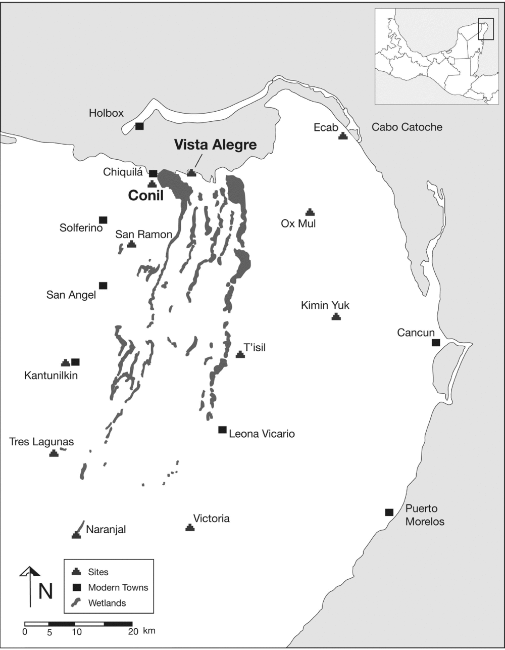
We investigate what the obsidian source data—obtained by visual analysis, X-ray fluorescence spectrometry (XRF), and instrumental neutron activation analysis (INAA)—and ceramic data from Vista Alegre (Figure 1) can reveal about the nature of commerce during the Terminal Classic period. The relative remoteness of Vista Alegre sets it apart from other coastal sites in the northern Maya lowlands during the Terminal Classic (e.g., Uaymil, Isla Cerritos, Emal, Xcaret) and provides an opportunity to investigate how the restructuring of ancient Maya economic systems dramatically increased opportunities for coastal peoples and their access to materials outside of major political centers. Of special interest are obsidian artifacts from central Mexican sources. The imported Mexican materials indicate participation in long-distance maritime exchange, which appears to have been largely dominated by Chichen Itza and its port site of Isla Cerritos (e.g., Andrews et al. Reference Andrews, Michel, Stross, Rivero and Asaro1989), approximately 110 km to the west of Vista Alegre. The ceramic data, in particular the relative abundance of nonlocal types associated with the Sotuta ceramic complex, provide corroborating evidence for the dramatic increase in long-distance trade at Vista Alegre during the Terminal Classic. It is important to note that due to issues of ceramic chronology in northern Yucatan, we conflate the Terminal Classic and Early Postclassic periods to better situate the Vista Alegre data in a comparative regional temporal framework (see Table 1).
Map of Yalahau region.

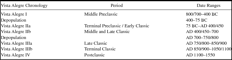
Vista Alegre Chronological Periods.

Andrews (Reference Andrews, Clancy and Harrison1990) provides a thorough examination of the various roles of port sites in the Maya area. He proposes a classificatory scheme based on the functional differences between four general and four specialized types of ports, although it is important to note that these functional categories are not mutually exclusive. As Andrews (Reference Andrews, Clancy and Harrison1990:162) states, “It is impossible to assign any given coastal site to an exclusive category. Most fit into several, if not all, categories.” In the case of Vista Alegre, the island might have started off as a coastal community focused on fishing and harvesting near-shore resources between the Middle Preclassic and Early Classic periods. Following these initial occupational phases, population at the site appears to have dwindled in the Late Classic, and the site was abandoned during the eighth century. Once the site was reoccupied in the ninth century, it developed into a specialized trading port during the Terminal Classic. The inhabitants of Vista Alegre were involved in exchange of obsidian, ceramics, shell items, and possibly perishable goods such as salt and cotton, and they would have provisioned traders with food and water. These traders moved goods from as far south as southern Belize, up and around the Caribbean coast, and into the Gulf of Mexico, and in the process played a key role in transforming economic systems in the Maya Lowlands.
The Port Site of Vista Alegre
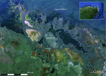
The small site of Vista Alegre is located on a mangrove-shrouded, inner-coastal island approximately 7.5 km east of the modern town of Chiquilá along the northern coast of the Yalahau region of Quintana Roo (Figure 1). Its location would have made it the first, or last – depending on direction of travel – precolumbian port site along the northern coast of the Yucatan Peninsula. The site is defined by the natural topography of the island (Figure 2). Lagoons surround the majority of the island. Mangroves, tintales (dyewood ecosystem), and tidal flats characterize the areas to the southeast and southwest. The island itself consists of the elevated, forested area upon which the site was built, much of which is the product of centuries of occupational debris.
Satellite image of the area around Vista Alegre (base image from Google Earth).

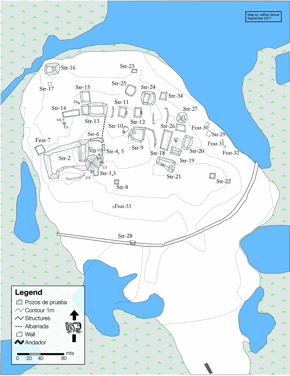
The island measures approximately 385 m east-west by 630 m north-south and covers an area of about 16 ha. The major constructions are situated in the northern part of the island. A total of 40 structures and features (Figure 3), including platforms, mounds, and a principal pyramidal structure, have been registered and mapped by members of the Proyecto Costa Escondida (PCE; see Glover and Rissolo Reference Glover and Rissolo2010, Reference Glover and Rissolo2017; Glover et al. Reference Glover, Rissolo and Mathews2013). The pyramid, 11 m high, is one of the tallest along the north coast and affords unobstructed views of the coastline. In addition to the structures and features, project members have recorded a wall and a 1.4 km andador (raised walkway; Supplemental Figure 1) along with another temple structure on the mainland. The wall runs across the middle of the island in a 400 m arc and terminates in the harbor areas on either side of the site. There is a 3 m wide formal opening in the wall and it ranges from 4–7 m thick (Supplemental Figure 2). The wall is an interesting feature for a port site because it implies a perceived threat to the people and goods at the port. Similar features have been documented at other coastal sites such as Emal (Kepecs Reference Kepecs, Smith and Berdan2003), Xcaret (Andrews and Andrews Reference Andrews IV and Andrews1975), and Tulum (Lothrop Reference Lothrop1924).
Site map of Vista Alegre.

Archaeological Contexts at Vista Alegre
Members of the PCE collected the artifacts discussed here during the 2008 and 2011 field seasons. Although some of the data come from surface collections, the vast majority are from nine off-structure test excavations (see Figure 3). Units 1 through 7 are all 1 m × 1 m, and Units 8 and 9 are adjacent to one another and create a 1.5 m × 2 m unit. These units were spread across the island to collect samples from a variety of contexts. The stratigraphic integrity of these units was not ideal due to their off-structure location and bioturbation. Recent excavations conducted during 2016, nonetheless, have helped us better understand the stratigraphy of the island. We have recovered Terminal Preclassic floors and burials over 2 m below the current ground surface. These finds reinforce our initial interpretation that there are intact Terminal Preclassic and Early Classic deposits at the island and that large parts of the island have been anthropogenically modified because of two interrelated processes: refuse disposal and episodic infilling. The episodic infilling appears to have occurred between the Late Classic and Postclassic periods, perhaps as a response to rising sea levels (see Beddows et al. Reference Beddows, Glover, Rissolo, Carter, Jaijel, Smith and Goodman2016 for further discussion of this topic at Vista Alegre). Although the infilling makes use of earlier materials, it is important to note that these infilling activities have not significantly affected the stratigraphic integrity of these earlier deposits. For example, three 14C assays were run on carbonized botanical remains from the lowest levels of Units 6 and 9 and on four of the burials recovered in Units 5, 8, and 9 (see Figure 3). The samples from the lowest levels date between cal AD 260 and 440 (see Supplemental Table 1). The pottery from these levels (see below) was consistent with these dates and included local Early Classic polychromes (Timucuy group) and Terminal Preclassic bichromes with no later pottery and, with only one exception, no obsidian. The radiocarbon assays we have from samples above these deposits date to the Late Classic and Terminal Classic periods (see Supplemental Table 1), although those deposits include earlier ceramic materials. Again, this appears to be a result of infilling activities that made use of earlier materials combined with refuse disposal. The entire island is incredibly rich in artifacts and ecofacts, especially around its margins. The dense, midden-like deposits most likely resulted from having limited space for trash disposal on this small island.
The archaeological contexts are admittedly mixed, but the vast majority of the obsidian artifacts were recovered in the upper levels of the units, which correspond predominantly to the Terminal Classic and Postclassic periods. In addition, although the site had a robust occupation during the Terminal Preclassic and Early Classic periods, the paucity of obsidian in the interior Yalahau region during these periods (see Glover Reference Glover2006, Reference Glover2012) and the lack of obsidian associated with undisturbed deposits from these time periods at Vista Alegre strongly suggests that the vast majority of the obsidian materials recovered at Vista Alegre date to the Terminal Classic and Postclassic periods and are not a result of obsidian trade before or during the Early Classic. Technological analyses of the obsidian blades also strongly indicate that most date to the Terminal Classic or Postclassic periods.
Ceramic Analysis and Long-Distance Ceramic Exchange at Vista Alegre
Our working chronology of Vista Alegre is based on ceramic data (n = 8,723) from our 2008 and 2011 off-structure, test-pitting program, complemented by Sanders's (Reference Sanders1960) earlier findings. We have divided the settlement history into four major periods of occupation (VA I--IV) ranging from the Middle Preclassic to the contact period (Table 1; see Glover, Rissolo, Ball, and Amador Reference Glover, Rissolo, Ball and Amador2011; Glover, Rissolo, and Mathews Reference Glover, Rissolo, Mathews and Ford2011). For our purposes here, we focus on the Late Classic through Postclassic periods.
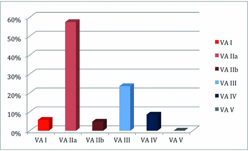
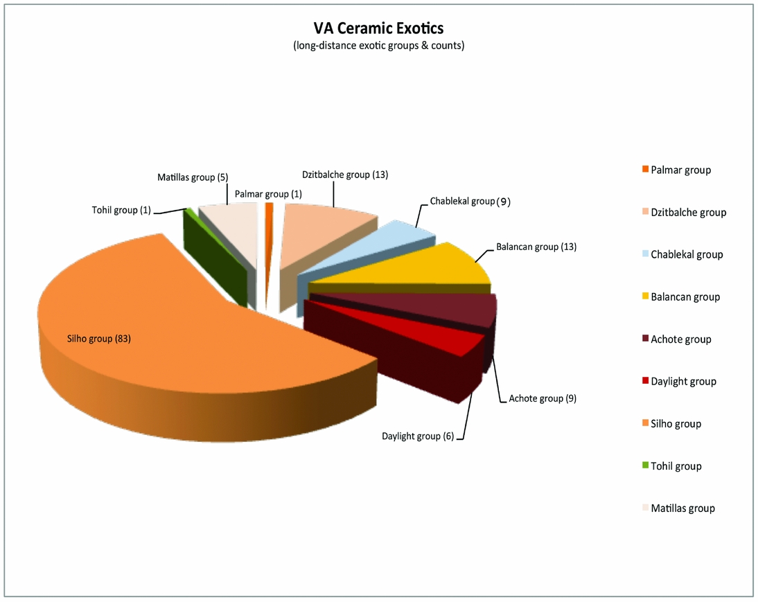
The Vista Alegre ceramic typology documents the occupational history of the site (Supplemental Table 2; Figure 4). Supplemental Table 3 provides counts for all identified ceramic groups, and Figure 5 presents counts and percentages for all identified “long-distance” exotic ceramics using raw sherd numbers. Given the limited and stratigraphically mixed samples available for the present assessment, anything beyond the foregoing would be misleading, whereas what is presented is reliable and accurate.
Vista Alegre phase diagnostics (n = 2953).

Count of “exotic” ceramic groups identified at Vista Alegre.

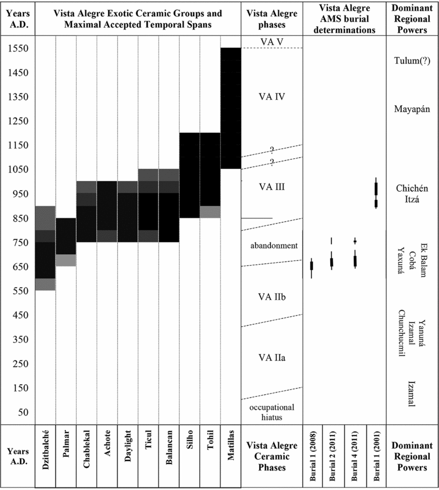
The Vista Alegre ceramic sequence and inferred occupational history is a fairly straightforward one for the northeastern Peninsula with one or two minor nuances. From the Late through Terminal Classic periods on into the full Postclassic, the site functioned primarily as a habitational settlement and possible commercial entrepôt. In the Postclassic, Vista Alegre also became an important offertory or pilgrimage shrine-site. There is also an apparent break and occupational gap in the history of the site in the early eighth century. This possible hiatus between Vista Alegre (hereafter VA) IIb and IIIa is suggested by the absence of such widespread, pan-Lowland decorated finewares of the mid to late seventh and early eighth centuries such as Petkanche Orange-polychrome, Moro Orange-polychrome, Egoista Resist, and Chimbote Cream-polychrome. All of these types are well to very well represented at occupied Middle and Late Classic northern coastal plain and eastern Lowland sites (Ball Reference Ball and Ball1978). The absence of Arena Red at the site is also of note, given its considerable importance at inland Coba and Yaxuna during the Late Classic period (González and Stanton Reference González and Stanton2013; Johnstone Reference Johnstone2001). We believe it significant that ceramic diagnostics of the late fifth to sixth century occur in substantially smaller quantities than do those of the late second through early fifth centuries, and that wares indicative of a late sixth to early seventh century presence appear in even lower frequencies. This suggests a declining on-site population over the later part of the Early Classic and early Middle Classic, with complete abandonment of the site no later than AD 700. Three sets of dated human remains with 2-sigma 14C midpoints in the mid to late seventh century help us define the end of VA IIb. A fourth set of remains with a 2-sigma midpoint at the beginning of the tenth century provides the only absolute chronometric anchor for the VA III period (Figure 6; Supplemental Text 1).
Vista Alegre exotic ceramic groups with maximal accepted temporal spans. Differential shading indicates consensus confidence levels for indicated temporal intervals. VA phase dating is based on comparative typology and is independent of site radiocarbon determinations (see Supplemental Table 1). Chart by Joseph W. Ball.

The VA III ceramic assemblage has been divided into IIIa and IIIb temporal facets. Chichen-related elements defining IIIb joined an already-existing Cehpech-like assemblage (IIIa) that embodied local, Coba region, and western coastal materials, and very much resembled the slateware-associated assemblages developing elsewhere across the northern plains during the late eighth and ninth centuries. The IIIb facet is defined by Sotuta slatewares, best represented by Balantun Black-on-slate (a domestic slateware strongly associated with Chichen Itza) and Silho Fine Orange. Based on our data, we propose strong connections between Vista Alegre and Chichen Itza during the Terminal Classic. This builds on and reinforces previous research documenting how the control of portions of the north and east coasts of Yucatan was critical to the rise of Chichen Itza to prominence during this period. These actions allowed the city to become a major player in circumpeninsular trade routes, as evidenced by Sotuta slatewares along with Silho Fine Orange and Tohil Plumbate pottery at coastal sites along the Caribbean and Gulf coasts (Braswell Reference Braswell, Smith and Berdan2003; Guderjan et al. Reference Guderjan, Garber, Smith, Stross, Michel and Asaro1989; Kepecs et al. Reference Kepecs, Feinman and Boucher1994; McKillop Reference McKillop1996; Robles Castellanos and Andrews Reference Robles Castellanos, Andrews, Sabloff and Andrews V1986). The connection of Chichen Itza to coastal trade is exemplified by Isla Cerritos (see Andrews et al. Reference Andrews, Negrón, Castellanos, Palma and Rivero1988; Cobos Reference Cobos2010). Radiocarbon determinations from Isla Cerritos cluster between AD 860 and 1020 (Andrews et al. Reference Andrews, Negrón, Castellanos, Palma and Rivero1988) and provide an important correlate for the growth of Chichen Itza (Cobos Reference Cobos, Demarest, Rice and Rice2004; although see Stanton and Gallareta Negrón Reference Stanton and Negrón2001 for a critical discussion of the presence of Sotuta ceramics). The ceramic evidence collected at Vista Alegre appears to do the same, providing material evidence of significant differences in long-distance trade associated with the era of fluorescence of Chichen Itza.
In an effort to meaningfully evaluate the place of ceramics in the involvement of Vista Alegre in long-distance exchange, we eliminated all arguable or ambiguous units and have tallied only what are unquestionably true exotic materials such as fine paste wares, Plumbate, and a very few select gloss wares (Figures 5–7; see Supplemental Text 2). The resulting statistics offer insights into the changing importance both of exotics and of foreign ceramic exchange in the history of the settlement (Figure 7). Although we presently lack sufficient data from Vista Alegre itself to support the argument, the group-by-group vessel form repertoires, quantitative abundance, and overall recovery contexts of the specific exotic potteries identified (Figure 5) tend to controvert likely roles for the majority of them as culturally significant social currencies for gifting or formal exchanges, as was the case for so much of the Late Classic polychrome-painted ceramic fineware. Instead, the majority of Terminal Classic exotic ceramics, much like obsidian, were commodified valuables rather than sumptuary goods. In contrast, a solitary incidence of Palmar Orange-polychrome most likely from southern Campeche/Quintana Roo or northern Petén more likely reflects some form of social exchange than it does commercial “trade,” as do six Daylight group (northern Belize) occurrences. Although not the result of commercial trade, as we argue the other exotics are, these examples do begin to highlight the social connections that facilitated long-distance trade.
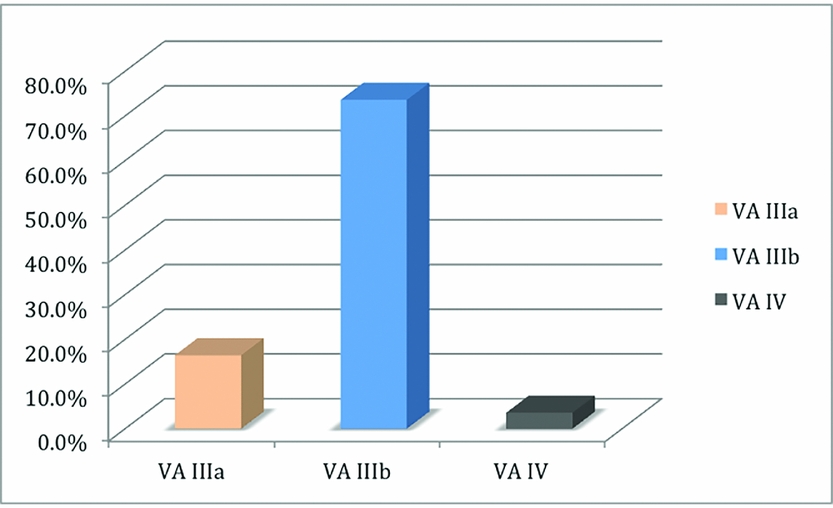
Vista Alegre “exotics” by phase.

Exotic pottery made up about 1.6% (140 of 8,723 sherds) of the total sample recovered at Vista Alegre to date. Although this percentage might appear small, the percentage of exotics in the Yalahau regional collection (Amador Reference Amador2005; Glover Reference Glover2006) is only 0.28% (35 of 12,518 sherds). In addition, if we compare Vista Alegre to the off-structure test-pitting data from Isla Cerritos (Cobos Reference Cobos2010), which is the most comparable dataset, the absolute number of exotic sherds is similar (n = 140 [VA] vs. n = 168 [IC]), and there are nine different exotic types present at Vista Alegre versus five types in the Isla Cerritos sample. Most importantly, the exotic pottery at Vista Alegre was decidedly not evenly distributed throughout the occupational history of the settlement. True “foreign” exchange of any kind is not identifiable until well into the eighth century with the appearance of such recognized exotics as Fine Gray Ware. To facilitate temporal analysis, we quantified the exotic sherds separately as an independent set within the larger sequence and compared their frequencies by ceramic phase (Figure 7). All evidence is that the defined Late and Terminal Classic phases (VA IIb, IIIa, IIIb) were of effectively comparable lengths, and the Postclassic period (VA IV) may have lasted anywhere from two to four times the length of the earlier spans. Other than awareness of this, no attempt was made to regularize the length of the VA phases for the comparisons. Each recovered exotic sherd was taken to represent a single, discrete occurrence of the ware/group/type represented.
Nearly 74% (n = 103) of the definitively “foreign” ceramics found are associated with the ascendancy of Chichen Itza and are generally accepted as being reflective of some level of interaction with that center (Johnson Reference Johnson2012, Reference Masson and Lope2014; Manahan et al. Reference Manahan, Ardren and Alonso2012). We emphasize that we do not count the well-represented (n = 202 sherds), clearly quotidian heavy domestic basins and jars of Balantun Black-on-slate or other Sotuta slatewares (i.e., Teabo and Dzitas group materials) among the exotics. We consider these more likely to represent local manifestations of emblematic Sotuta wares (see Supplemental Text 3).
In sum, our collection tracks a progressive increase in the presence of ceramic indicators of long-distance interactions at Vista Alegre from a late eighth through mid-ninth century startup (16.4%) to a late ninth and tenth century peak (73.6%) during the ascendancy of Chichen Itza, followed by a precipitous falloff (to 3.6%) at the end of and following the latter (Figure 7). With few exceptions—the Late to Terminal Classic Palmar Orange-polychrome and Daylight Orange occurrences—the ceramics involved all belong to domestic classes of pottery unlikely to have moved through gifting or other social exchange mechanisms as opposed to commercial ones. Thus, the exotic pottery found at Vista Alegre effectively reflects and tracks commercial engagement and trade as well as social and sociopolitical relationships. Eppich and Freidel (Reference Eppich, Freidel and King2015) have identified a close parallel scenario in an in-depth statistical analysis of ceramic distributions at El Peru-Waka. Their work highlights how different socioeconomic networks were at play simultaneously and how these different networks produced distinct distribution patterns. Of interest for us is the difference between polychromes, which moved through varied social/political networks, and the fine paste-wares, whose even distribution at El Peru-Waka indicate they were commodified products that were bought and sold in markets during the Terminal Classic. The greatly increased emphasis on commercial networks and the exchange of commercialized goods is what the evidence from VA IIIb times indicates.
Obsidian Analysis
Obsidian artifacts have long been used to understand economic interaction in past societies. Elemental homogeneity within a given geological source, and the unique chemical signatures of each source, allow for analysts, using XRF, LA-ICP-MS (laser ablation inductively coupled plasma mass spectrometry), or INAA, to determine which extrusive volcanic event created the source material. Thus, unlike most chert or flint artifacts, which are often not amenable to chemical sourcing, we can determine the beginning and ending points of ancient chains of exchange. The kinds of trade that occurred between these points, nonetheless, must remain purely hypothetical without detailed excavation of marketplace, production, and consumption contexts—contexts that have yet to be analyzed at Vista Alegre. Nevertheless, the percentages of obsidians from different sources provide information about the exchange networks that various polities were engaged in, and based on their geographic location, the routes those materials and the people moving them likely used to get there (see also Braswell Reference Braswell, Smith and Berdan2003; McKillop Reference McKillop, McAnany and Isaac1989, Reference McKillop1996; Nelson and Clark Reference Nelson, Clark, Gimpera and Rattray1998; Sidrys Reference Sidrys1977). We describe the chemical and visual sourcing techniques we used in this study, and then discuss the results in relation to previous obsidian distribution studies in the Maya Area. Of particular importance to our comparative project is Braswell's Reference Braswell, Smith and Berdan2003 study, which delineates and defines spheres of obsidian trade and interaction during the Terminal Classic, Early Postclassic, and Late Postclassic periods. As mentioned above, we conflate the Terminal Classic and Early Postclassic periods to better situate the Vista Alegre data in a comparative regional temporal framework (see Table 1). As it happens, the proportions of obsidian at Vista Alegre are rather unique, and speak to a possible role of the site as “middle man” in peninsular maritime trade.
Obsidian Sourcing Methods
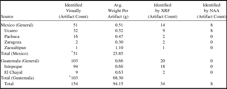
We used a combination of techniques to source the obsidian artifacts from Vista Alegre, including visual and chemical sourcing. Stage one was to sort the obsidians based on visual characteristics (n = 154); stage two was to test these determinations with XRF sourcing of a sample carried out by Shackley (n = 34); stage three was to reanalyze the materials visually, and then finally reconfirm a few blade fragments with INAA sourcing (n = 8). XRF and INAA were both used to confirm visual source attributions (see Supplemental Text 4 for further discussion of visual sourcing). All archaeological XRF samples were analyzed without destruction (see Supplemental Text 5 for detailed discussion of XRF methodology). Although inter-source elemental variability is a given in obsidian provenance studies, in some cases XRF can be insufficient for discriminating between distinct sources (Glascock Reference Glascock and Shackley2011; Shackley Reference Shackley2005). In this case, INAA can provide a much greater range of acquired elements, particularly the rare earth elements (REEs) that are poorly measured due to their small proportions in rhyolite (obsidian), but accurately measured by INAA. Glascock (Reference Glascock and Shackley2011) details this issue well for Mexican obsidian sources. In this study, it was difficult with XRF to discriminate between the Ucareo, Mexico, and La Union, Honduras sources. INAA was able to resolve this, and the assignment to Ucareo made more archaeological sense (Table 2; see Supplemental Figures 3 and 4).
Vista Alegre Obsidian—Count by Source and Method of Analysis.

*Artifact counts, weights, and averages from XRF and NAA anayses are included in the Identified Visually column, and should not be understood to be additional portions of the total sample of artifacts in this study.
*These artifact counts and average weights are based on all obsidian artifacts and include third-series blades as well as all other types of tools, debitage, and exhausted core fragments.
Results of Obsidian Analysis
The sourcing studies were carried out on a total of 154 obsidian artifacts, the majority of which are final-series blade fragments. A technological analysis of the artifacts suggest that Vista Alegre was more of a consumer than producer of obsidian blades, with 132 final-series blades, and only three first-series and two second-series blades.Footnote 1 Nonetheless, three third-series flakes, two exhausted cores, a distal rejuvenation flake, a hinge re-initiation flake, and three percussion flakes and blade fragments indicate that the inhabitants of Vista Alegre may have produced some blades, or perhaps imported a few pieces of random debitage. There was no evidence of small-scale debitage (i.e., microdebitage) usually associated with production. The percentages of first- and second-series blades, and even final-series blades, were not suggestive of a producer community, a very different pattern from that found at Wild Cane Cay by McKillop (Reference McKillop, McAnany and Isaac1989, Reference McKillop1996). Our present sample does not allow us to add to the debate about whether prismatic blade cores or finished blades were primarily traded in this region. Such scenarios can have important socioeconomic implications for the organization of economies in northern Yucatan. Virtually all of the platforms of the proximal blade fragments were pecked and ground (i.e., 25/26 total examples), which is a technological marker for Terminal Classic and Early Postclassic periods.
The density of obsidian artifacts at the site corroborates our argument that the quantity of obsidian moving through Vista Alegre far outpaced local demand. We calculated the density based on cubic meter of excavated material to have a comparative metric. The average density of obsidian recovered from the Vista Alegre excavations (n = 143) is 21.7 pieces of obsidian/m3 (10.1 g/m3), a density not far from the mean of the test pits at Mayapan (Masson and Peraza Lope Reference Masson and Lope2014: Table 6.18). But the obsidian at Vista Alegre is not evenly distributed. Although all test units produced obsidian artifacts, the least dense deposits of obsidian are located around the main pyramidal structure and the central plaza area. The densest deposits were recovered from Unit 7, which is located in the middle of the East Plaza Group, close to the eastern harbor area (see Figure 3). The upper two levels of this unit yielded a total of 28 obsidian fragments in 0.4 m3 of sediments (the equivalent of 70 pieces of obsidian/m3). This density is on par with the obsidian workshops identified at Mayapan (Masson and Peraza Lope Reference Masson and Lope2014:353), although as mentioned, there is no evidence of workshop activities at this time.
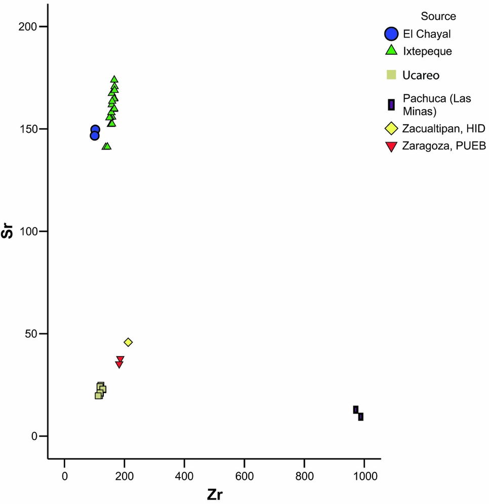
There were six sources identified in the Vista Alegre sample with two from Guatemala and four from Mexico (see Figure 8; Supplemental Table 4 for the XRF results). Guatemalan obsidians from El Chayal and Ixtepeque were more common than Mexican sources, which included Pachuca, Ucareo, Zaragoza, and Zacualtipan, by roughly two times, at 67% and 33% (Table 2). Ucareo was more common than Pachuca obsidian at 21% and 10% of the total obsidian, respectively, which is similar to the ratio at Chichen Itza at 30% and 22% (see Braswell Reference Braswell, Smith and Berdan2003). Zaragoza and Zacualtipan round out the remainder of the Mexican obsidians, at 1% and <1% of the total sample, which are low figures similar to other sites that feature these import items (see Braswell Reference Braswell, Smith and Berdan2003:Tables 20.1 and 20.2). Contrary to what might be expected of the directionality of west-to-east maritime trade, Uaymil, an island site opposite Vista Alegre on the west coast of the Peninsula, features virtually the same proportion of Guatemalan to Mexican obsidian found at Vista Alegre at 64% to 36% (Braswell et al. Reference Braswell, Paap and Glascock2011), although the sample size is small. This distribution gives the impression that Isla Cerritos may have been a central node for Mexican imports by sea with similar exchanges emanating east and west from there. Nevertheless, although Uaymil features equal percentages of both Pachuca and Ucareo artifacts (i.e., 11% for both Pachuca and Ucareo), the Guatemalan obsidians are dominated by El Chayal as opposed to Ixtepeque—a mirror image of the Vista Alegre pattern. An east-west division between Ixtepeque and El Chayal exchange spheres is common elsewhere in the Maya Lowlands (see below), but we must also acknowledge that the ratio of Ixtepeque to El Chayal materials may be a result of chronological as well as spatial factors. Ixtepeque became the dominant source used in the Postclassic period in the Maya area. Although the ceramic data (see above) do not point to a robust population on the site during the Postclassic (VA IV), we cannot completely discount that some of the Ixtepeque materials arrived at the site during this lengthy period. That said, 11% of the obsidian in Chichen Itza was from the Ixtepeque source during Terminal Classic and Early Postclassic periods (Braswell Reference Braswell, Smith and Berdan2003), indicating that some of that material must have been arriving at the site by some form of long-distance exchange, likely via coastal sites, such as Vista Alegre and Isla Cerritos. This is supported by McKillop's (Reference McKillop, McAnany and Isaac1989, Reference McKillop1996) work at Wild Cane Caye, which revealed a large quantity of Ixtepeque obsidian associated with Sotuta-related ceramics and Mexican obsidians. In fact, at Wild Cane Cay, there was an 800% increase in the amount of obsidian during the Terminal Classic and Early Postclassic, 70% of which was attributed to Ixtepeque, with evidence of blade production on site, as well (McKillop Reference McKillop, McAnany and Isaac1989).
Zr versus Sr bivariate plot of the elemental concentrations for all the archaeological specimens.

By a wide margin the most common obsidian at Vista Alegre was from Ixtepeque at 61% of the total, and a striking 91% of Guatemalan obsidians. This high proportion of Ixtepeque obsidian appears to align the site more with Braswell's (Reference Braswell, Smith and Berdan2003) Southeastern Maya Sphere than that of the Lowland Maya Sphere, but the relatively high percentage of Mexican obsidian indicates its interaction with his proposed International Sphere. In reality, of course, the spatial patterning of obsidian source ratios is more clinal in nature without fast boundaries between most sites in the Terminal or Early Postclassic periods. Some polities, such as Coba, appear to have focused more on inland trade with 97% of its obsidian sourced to El Chayal (Braswell and Glascock Reference Braswell, Glascock and Glascock2003:Table 2). Although there is certainly a strong chronological component at work, given that El Chayal was the common source across the Lowlands during the Classic period, these data may indicate that Coba was excluded from the trade networks in which Vista Alegre, Chichen Itza, and other sites such as Wild Cane Cay were enmeshed. It is unclear exactly how late Coba was importing El Chayal cores and the extent to which these exchanges related to obsidian trade in the Terminal Classic at Chichen Itza.
At Vista Alegre, El Chayal obsidian makes up 6% of the total sample and 9% of Guatemalan obsidians. While there is a chronological element at play, the low percentage of this Guatemalan source also marks the disconnection between coastal and inland trade routes. One might ask how or why Vista Alegre has any El Chayal obsidian at all? Instead of reciprocal exchange with inland sites for obsidian of a lower quality, a more likely answer is that the coastal routes were still being supplied through the Motagua River valley, which continued to be a route for both Ixtepeque and El Chayal obsidians for all time periods (e.g., Healy et al. Reference Healy, McKillop and Walsh1984; McKillop Reference McKillop1996). McKillop (Reference McKillop1996) documents this pattern for the Belizean coastal sites where El Chayal obsidian was still present at sites into the Postclassic, just in lower relative percentages than in the Late Classic.
Although a high percentage of obsidian was imported from Mexican sources, it does not rival that of Isla Cerritos or Chichen Itza and appears as a gradient between Caribbean sites (see Braswell Reference Braswell, Smith and Berdan2003; Golitko et al. Reference Golitko, Meierhoff, Feinmann and Williams2012; Guderjan et al. Reference Guderjan, Garber, Smith, Stross, Michel and Asaro1989; McKillop Reference McKillop1996) and Isla Cerritos ratios. It is important to note that the initial obsidian ratios reported for Isla Cerritos (Andrews et al. Reference Andrews, Michel, Stross, Rivero and Asaro1989) were based only on the chemically sourced data and do not include more recent visually sourced data where the ratio between Mexican and Guatemalan sources ranges from 60/33 (Clark Reference Clark2015, n = 193) to 48.5/50 (Cobos Reference Cobos2010, n = 68). Although these ratios are not as weighted toward Mexican sources as those originally reported in the literature, Isla Cerritos still had access to obsidian from seven different sources, something not found at many Maya sites. In short, Vista Alegre partook in exchange with sites to the west, as evidenced in the ceramic data, but clearly, distance does matter. The majority of obsidian was obtained from the Ixtepeque source, and almost all of the blades indicate a use of the pecked and ground platform preparation, which is a marker for the Terminal Classic and Postclassic. There is little evidence at this point to suggest that Vista Alegre knappers were making blades on site, but future excavations may reveal production workshops or areas. However, the ratios show that traders on the north coast were tied through some form of exchange, perhaps involving shells or perishable commodities (i.e., cotton or foodstuffs), with Isla Cerritos and other northern littoral sites. We speculate that Vista Alegre can best be understood as filling a gap in circumpeninsular maritime trade, perhaps occupying a bottleneck where the occupants of seafaring canoes preferred to pay a fee to navigate the much calmer waters of the Laguna Holbox, or at least engage in valuable exchanges for commodities such as shells and cotton or shelter, food, and water, which are not always easily accessible along the more marginally inhabitable sections of the coastline.
Discussion
In line with Rice (Reference Rice, Brumfiel and Earle1987), we argue that imported obsidian was treated as a valued exotic good up until the Terminal Classic and Postclassic periods when, in Healan's (Reference Healan2009) words, a “banalization” of obsidian appears to have taken place. Dual factors of the introduction of pecked and ground platform preparation and apparent unrestricted access to the Ixtepeque source after the decline of the Copan dynasty opened a veritable flood gate of high quality, easily produced blades into the Maya heartland. In general, large obsidian nodules became less available at some geological obsidian sources over time, such as El Chayal (Suyuc Reference Suyuc Ley, Hruby, Braswell and Mazariegos2011); consequently, core sizes became smaller. Responses to diminishing core size appear to have included more efficient, but difficult, reduction techniques by specialists who may have safeguarded esoteric production knowledge (Hruby Reference Hruby2006; Hruby et al. Reference Hruby, Hernandez, Clark, Laporte, Arroyo and Mejía2007). It appears that up until the Terminal and Postclassic periods, obsidian was usually restricted in the Maya Lowlands, excepting outlier sites in eastern Guatemala and the Baja Verapaz, such as Cancuen, Copan, and Quirigua, a pattern that appears to hold true in the northern Maya lowlands during the Classic Period (see Braswell Reference Braswell, Smith and Berdan2003:140). Aside from exhaustion of obsidian nodules at the source, other factors involved in this restriction include the “bottlenecked” or attempted control of riverine, maritime, and terrestrial trade routes inspired by economic demand and political turmoil, but also by the ebb and flow of intensive warfare between polities (cf., Golden et al. Reference Golden, Scherer, Muñoz and Hruby2011).
In the western and central Petén during the Classic period, blade production can be characterized as small scale, restricted, and also relatively efficient in terms of blade thickness to width ratios (Hruby et al. Reference Hruby, Hernandez, Clark, Laporte, Arroyo and Mejía2007). Restricted obsidian blade production practices, nevertheless, appear to have declined with the disintegration of centralized governance in southern lowland centers during the Terminal Classic. Attempted control of obsidian sources and trade routes also declined, thus allowing these materials to flow throughout the Maya area, especially relating to the Ixtepeque source in eastern Guatemala (e.g., Braswell Reference Braswell, Smith and Berdan2003; Golitko et al. Reference Golitko, Meierhoff, Feinmann and Williams2012; McKillop Reference McKillop, McAnany and Isaac1989, Reference McKillop1996). Technological evidence of this political decline consists of more accessible blade-making techniques – specifically, the use of pecked-and-ground platforms throughout Mesoamerica. This technique was more time consuming for the core producer, but made blade making easier for the novice (see Healan Reference Healan2009), and the less restricted influx of blade cores allowed for households of more varied socioeconomic status to produce larger quantities of blades for quotidian and specialized uses (e.g., Rice Reference Rice, Brumfiel and Earle1987). Of the 29 proximal fragments of final-series blades recovered from Vista Alegre, only one was not modified by pecking and grinding (sourced to El Chayal and perhaps an artifact of the Late Classic) Platforms from both Mexican and Guatemalan sources had been modified in this way, marking them as either Terminal or Early Postclassic in date.
It is likely that the expanded use of the pecked-and-ground platform does not represent the serendipitous discovery and immediate adoption of a new technology that made blade making more accessible to a wider segment of society, but rather a breakdown of what Inomata (Reference Inomata2001) has described as “involutionary” tendencies in Classic Maya craft production. State- or elite-controlled craft production, especially of prestige goods, lead to a decline or a restriction in the expression of technological innovations, although in some cases increased creativity in artistic expression. Technologies that conflicted with, or threatened, state power may not have been encouraged, even in the case of quasi-prestige goods such as obsidian blades. More accessible blade technologies could have threatened exchange alliances within and between polities. The fractured state of many polities at the end of the Classic period, both in central Mexico and the Maya area, may have led to a reconceptualization of the economic benefits of obsidian and ceramic trade across Mesoamerica. The banalization of obsidian blades, especially in the northern lowlands where high-quality chert was lacking, likely helped fuel the general transition to more open markets in the Terminal and Postclassic periods.
These changes are evidenced in the obsidian and ceramic data associated with Chichen Itza. Although the majority of obsidian found in the Maya lowlands comes from the Guatemalan highland sources of El Chayal, Ixtepeque, and San Martín Jilotepeque, the obsidian data from Isla Cerritos and Chichen Itza reflect “a clear break with the traditional obsidian trade networks of the Maya Lowlands, which had previously been dominated by the Guatemalan obsidian trade” (Andrews et al. Reference Andrews, Michel, Stross, Rivero and Asaro1989:361). Braswell (Reference Braswell, Smith and Berdan2003:140) has referred to this as the “international sphere” to denote this marked contrast to the pattern of obsidian distribution in the rest of the Maya Lowlands. What we see in the obsidian and ceramic data from Vista Alegre is clear engagement by the inhabitants of Vista Alegre with players in these new networks. Less clear, however, is what form this engagement took.
Given the increased role of markets during the Terminal and Postclassic periods (e.g., Braswell Reference Braswell, Smith and Berdan2003; Braswell and Glascock Reference Braswell, Glascock and Glascock2003; Garraty and Stark Reference Garraty and Stark2010; Hirth and Pillsbury Reference Hirth and Pillsbury2013; Masson and Freidel Reference Masson and Freidel2012), it is still unclear how coastal traders may have been integrated into this transformed market-based economy and the level of autonomy these traders enjoyed. Although Kepecs (Reference Kepecs, Smith and Berdan2003:268) raises the interesting proposition that “[w]ith the fall of Chichén, entrepreneurs broke free of political authority, holding the Itzás’ fortunes in their hands,” Braswell (Reference Braswell, Garraty and Stark2010:136–139) argues that the apogee of political power in Chichen Itza correlated with the peak of open market exchange in the precolumbian Maya area. He tracks the trajectory of economic development in the Late and Terminal Classic periods arguing that Chichen was first involved in bounded market-exchange during the ninth century, which developed into open market exchange in the tenth century. Following the political decline of Chichen, he argues the class-based distribution patterns evidenced at Mayapan (Braswell and Glascock Reference Braswell, Glascock and Glascock2003) suggest a return of simpler polyadic forms of exchange where the Mexican obsidian is replaced by material from Ixtepeque (Braswell Reference Braswell, Garraty and Stark2010:137).
Following Braswell (Reference Braswell, Garraty and Stark2010), then, the political and economic conditions of the tenth century appear to be the most likely to produce specialized coastal trading centers. We contend that such port sites developed in tandem with, and made possible, the more open market exchange system described by Braswell (Reference Braswell, Garraty and Stark2010). Vista Alegre, like other coastal sites during this time period (i.e., Wild Cane Cay), has a high density and diversity of goods and appears to be a place where multi-ethnic traders may have met as they plied the waters of the north coast. In addition to the artifactual assemblage, the location of coastal sites can also help us understand the role(s) they may have played in this transformed economy.
One of the reasons, of course, these port sites existed was to help traders overcome the logistical challenges involved in moving goods and people around the Peninsula. Vista Alegre is the first (or last, depending on direction of travel) precolumbian port along the north coast of the Yucatan Peninsula. In the Terminal Classic, coastal sites from El Meco on the Caribbean to Isla Cerritos are separated by distances of 30 km to 40 km. This correlates exceptionally well with Adams’ (Reference Adams, Lee and Navarette1978:27–28, 33–34) estimate of 40 km a day for canoe travel over slow-moving water. Given the need for canoes to resupply with drinking water (see Beddows et al. Reference Beddows, Glover, Rissolo, Carter, Jaijel, Smith and Goodman2016 for a discussion of water access at Vista Alegre) and food for the paddlers, this spacing between sites points to the significance of coastal locales for facilitating long-distance trade and provisioning traders. Although this is probably true of all coastal sites to a certain degree, the issue of access to resources is exacerbated on the north coast of Quintana Roo, where canoe-based reconnaissance in 2006 revealed no other sites and that the majority of the coastline is composed of flooded mangrove forests (see Glover and Rissolo Reference Glover and Rissolo2010). In addition, the apparent lack of inland settlement in the Yalahau region during the Terminal Classic and Early Postclassic periods, as well as the distance of the site from other powerful polities, makes the logistical challenges faced by merchants on this stretch of coast more severe. By considering the location of Vista Alegre, its material assemblage, and the fact that it was reoccupied after a hiatus of almost 100 years, we contend that Vista Alegre is a prime candidate as a site set up and run by merchants. The merchants likely operated with more freedom during this time as markets opened up, and they became key players in forging the interconnected Mesoamerican economic system.
Concluding Remarks
The evidence from Vista Alegre appears to support Braswell's (Reference Braswell, Garraty and Stark2010) claim that the peak of the power of Chichen Itza coincided with a period of diverse economic opportunities for coastal peoples. The ceramic data reveal insight into the directionality of trade and helps us constrain the time period most likely associated with the obsidian data recovered. When combined, these data indicate the marked increase in long-distance trade that we see at other coastal sites (e.g., Guderjan and Garber Reference Guderjan and Garber1995; McKillop Reference McKillop1996) in the Terminal Classic and Early Postclassic periods, and that we would expect, given robust market economies. What makes Vista Alegre a unique case is that the site was reoccupied after approximately a century of abandonment at the end of the Late Classic, but by whom, we do not yet know. The site was quite isolated from any other coastal site or inland center (40 km by water to the next known site). Coba and Ek Balam were the closest major centers, each located approximately 100 km away. In sum, Vista Alegre is a site clearly dedicated to maritime commerce during this time period. Although the salt, cotton, and people do not preserve well in the archaeological record, obsidian and the ceramic evidence serve as important proxies when we attempt to reconstruct the social, political, and economic networks operating during the Terminal Classic, a truly transformative time in the Maya area.
Acknowledgments
We thank the Consejo de Arqueología of INAH for granting us permits to conduct this research. Our research would not have been possible without support from Georgia State University, the Waitt Institute, the Explorers Club, the Foundation for Advancement of Mesoamerican Studies, Inc., the National Oceanic and Atmospheric Administration's Office of Ocean Exploration and Research, and the National Science Foundation (#1530245). In Quintana Roo we are grateful for the continued support of Adriana Velázquez Morlet, and we would also like to thank the people of Chiquilá and San Ángel. We thank Douglas Kennett for preparing the bone samples for us. We thank Jennifer Taschek and Fabio Esteban Amador for their help with the ceramic analysis and illustrations, and all PCE members.
Data Availability Statement
The materials that are the subject of this study will remain in temporary storage at the Proyecto Costa Escondida Research Lab and Bodega in Kantunilkin, Quintana Roo, Mexico for the duration of the project's research. Following the completion of the project, these materials will be turned over to INAH, as required by law, and will be curated either by Centro INAH Regional Chetumal or Cancun. The digital data are in possession of the authors who have plans to archive their data at tDAR when they complete their NSF-funded project.
Supplementary Materials
To view supplementary material for this article, please visit https://doi.org/10.1017/laq.2018.22
Supplemental Table 1. List of 14C dates from archaeological contexts at Vista Alegre.
Supplemental Table 2. Typological Inventory of the Vista Alegre Ceramic Collection (unweighted) compiled by Joseph W. Ball (units organized roughly by complex/phase, type-class, and gross chronology).
Supplemental Table 3. Counts of all Vista Alegre ceramics.
Supplemental Table 4. Elemental concentrations and source assignments for the archaeological specimens. All measurements in parts per million (ppm).
Supplemental Text 1. Note on processing of human bone for AMS Dates.
Supplemental Text 2. Note on Middle Preclassic pottery from Vista Alegre.
Supplemental Text 3. Observations about virtual absence of Peto Cream wares at Vista Alegre.
Supplemental Text 4. Details on visual sourcing methodology undertaken by Hruby with Vista Alegre materials.
Supplemental Text 5. Details on XRF methodology performed by Shackley.
Supplemental Figure 1. Picture of the andador that runs south from Vista Alegre to the mainland.
Supplemental Figure 2. Picture of the western portion of the wall where it meets the water.
Supplemental Figure 3. Sr versus Rb bivariate plot of the elemental concentrations for the Ucareo, La Union, and Vista Alegre samples.
Supplemental Figure 4. Fe versus Mn bivariate plot of the elemental concentrations for the Ucareo, La Union, and Vista Alegre samples.