INTRODUCTION
Archaeological Research at the Tlajinga District
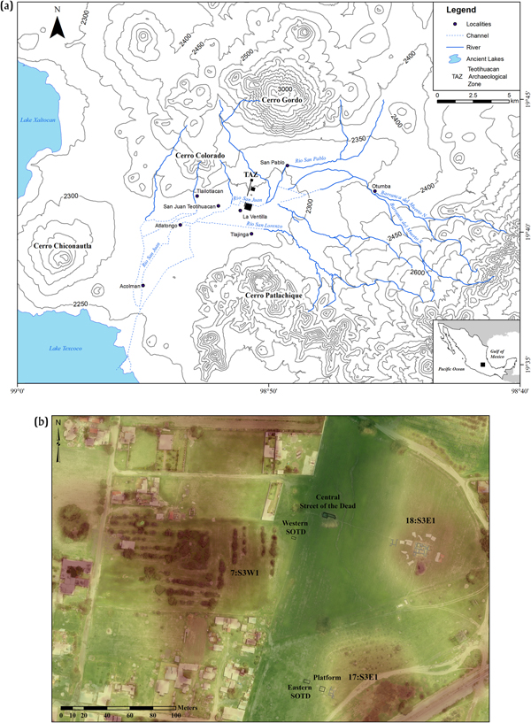
The ancient Mexican metropolis of Teotihuacan was the largest city in the Americas during the first centuries a.d. and it incorporated five or more ethnic groups with some spatial clustering within the city (Robertson Reference Robertson, Gallut and Peralta2005; Spence et al. Reference Spence, White, Rattray, Longstaffe and Blanton2005). During its life span of more than 600 years, size and population density varied strongly with a demographic peak in the Classic period (ca. a.d. 200–550) and decline in the Epiclassic period (starting at a.d. 550/650; Cowgill Reference Cowgill1997, Reference Cowgill2015; Nichols Reference Nichols2016). Teotihuacan's economy would have been one factor driving these demographic changes. One recent and central debate concerning Teotihuacan's economy centers on question of what forms of distribution and production were institutional versus market-driven (Carballo Reference Carballo, Hirth and Pillsbury2013; Manzanilla Reference Manzanilla, Manzanilla and Chapdelaine2009). Households, neighborhoods, and districts are critical units of analysis for such questions. The Tlajinga district, located in Teotihuacan's southern periphery, has been studied only to a very limited extent (e.g., excavation of residential unit 33:S3W1 by a team from Pennsylvania State University [Widmer and Storey Reference Widmer, Storey, Santley and Hirth1993, Reference Widmer, Storey, Arnauld, Manzanilla and Smith2012]). The Proyecto Arqueológico Tlajinga Teotihuacán (PATT) excavated two apartment compounds, Compound 17:S3E1 and Compound 18:S3E1, and the southern extension of the Street of the Dead at Tlajinga in 2013 and 2014 (Figures 1–3). The excavation at Tlajinga revealed crucial insights into relations between the epicenter and the periphery (Carballo et al. Reference Carballo, Hirth, Sariñana, Buckley, Ramón and Kennett2019).
Location and setting of the study area. (a) Map of Mexico showing the location of the study area, Tlajinga, south of the Teotihuacan Archaeological Zone (TAZ) passing the San Lorenzo River. The San Lorenzo soil profile studied herein is located at this river. Figure courtesy of Rodrigo Tapia-McClung. (b) Map showing the location of excavations areas at the Street of the Dead, Compound 18:S3E1, and the obsidian-working platform between the eastern Street of the Dead and Compound 17:S3E1. Figure courtesy of the Proyecto Arqueológico Tlajinga Teotihuacán.

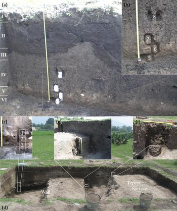
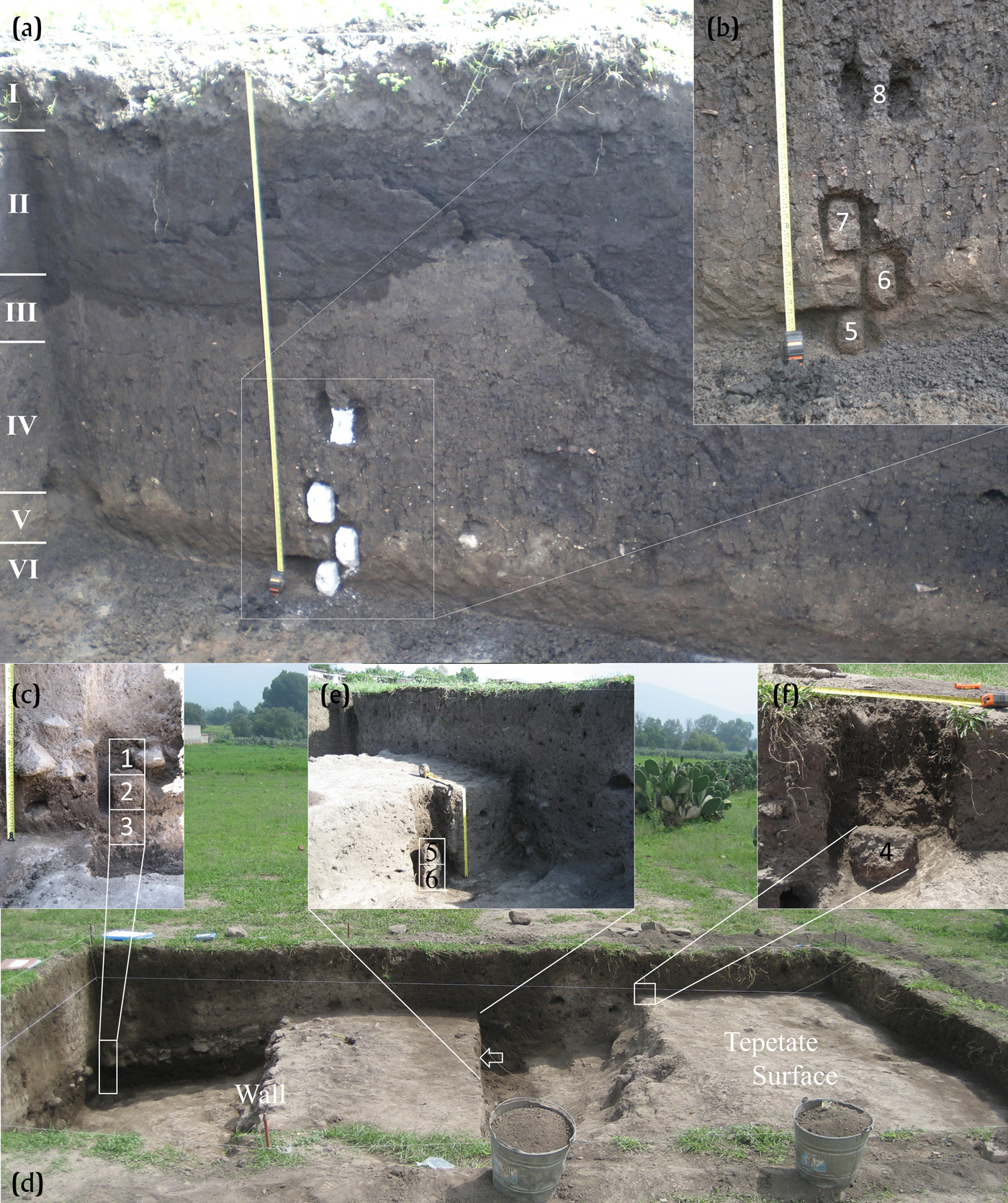
Block sampling in the Street of the Dead. (a) Excavation area in the central part of the Street of the Dead. This area was excavated to the upper surface of the indurated tepetate, which is overlain by several weakly developed soils, layers I to V. Depth of excavation area = 1.80 m. (b) Sequence of block samples PATT 14 5–8 that contain the tepetate and the infill of the Street of the Dead. (c) Sequence of block samples PATT 13 1–3 that were taken at the eastern border of the Street of the Dead. The samples contain the sloping, cut tepetate, an overlying brown layer, which, in turn, is overlain by a layer rich in rocks and ceramic. (d) Excavation area at the eastern border of the Street of the Dead. Note the presence of a wall construction here and that the tepetate slopes down from east to west. (e) Sequence of the block samples PATT 13 5 and 6 that contain the tepetate and an overlying brown layer. (f) Block sample PATT 13 4 that contains the sloping, cut tepetate and an overlying brown layer close to the current surface. Photographs by Stahlschmidt.
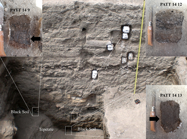
Block sampling in the South Profile of Compound 18:S3E1. Depth of section about 2.65 meters. Two blocks samples, PATT 14 9 and 14 13, were taken from a black layer overlying the tepetate here. The latter sample was collected from below Feature 36 that was dug into the tepetate. Note the black layer visible in the back side of each sample. A further block sample was taken from a layer with combustion material, PATT 14 12. Note the charcoal visible in the back of the sample. Photographs by Stahlschmidt.

Geoarchaeological research in Mesoamerica has been focused on the reconstruction of paleoenvironments (Dunning et al. Reference Dunning, McCane, Swinney, Purtill, Sparks, Mann, McCool and Ivenso2015), and the study of plant remains and paleosols are regularly used to reconstruct past environmental conditions and subsistence at Teotihuacan (see section Paleoenvironmental Research at Teotihuacan). One technique commonly employed in the study of paleosols is micromorphology (González-Arqueros et al. Reference González-Arqueros, Vazquez-Selem, Gama-Castro and McClung de Tapia2013; Rivera-Úria et al. Reference Rivera-Úria, Sedov, Solleiro-Rebolledo, Pérez-Pérez, McClung de Tapia, González and Gama-Castro2007; Sánchez-Pérez et al., Reference Sánchez-Pérez, Solleiro-Rebolledo, Sedov, McClung de Tapia, Golyeva, Prado and Ibarra-Morales2013; Sedov et al. Reference Sedov, Rivera and Solleiro-Rebolledo2009; Solleiro-Rebolledo et al. Reference Solleiro-Rebolledo, Sycheva, Sedov, McClung de Tapia, Rivera and Salcedo-Berkivich2011). Micromorphology, however, also has been successfully employed to reconstruct anthropogenic site formation processes in other time periods, people forming and altering deposits (Courty et al. Reference Courty, Goldberg and Macphail1989). The potential of micromorphology for this is rather underused in Mesoamerican archaeology (see Cabadas-Báez et al. Reference Cabadas-Báez, Sedov, Jiménez-Álvarez, Leonard, Lailson-Tinoco, García-Moll, Ancona-Aragón and Hernández-Velázquez2018; Simms et al. Reference Simms, Berna and Bey2013) and almost unexplored at Teotihuacan (Pecci et al. Reference Pecci, Miriello, Barca, Crisci, de Luca, Ortiz, Manzanilla, Blancas and Barba2018).
One important focus of our study is the microstratigraphic evidence of people creating and shaping deposits in order to investigate craftsmanship and domestic and urban life. More specifically, we are investigating the construction, use, and infill of Street of the Dead outside the epicenter. Blancas et al. (Reference Blancas, Barba, Ortiz, Acosta, Mejía Ramón and Carballo2019) show that the tepetate, the indurated volcanic tuff substrate (Williams Reference Williams1972; Solleiro-Rebolledo et al. Reference Solleiro-Rebolledo, Sedov, Gama-Castro, Román and Escamilla-Sarabia2003), has a lower topography inside the Street of the Dead here. One possible explanation for this is that people cut into the tepetate to continue the axis of the Street of the Dead. The project is also investigating the possible in situ preservation of obsidian working at Compound 17:S3E1 (Hirth et al. Reference Hirth, Carballo, Dennison, Carr, Imfeld and Dyrdahl2019) to explore in craftsmanship and status. Lastly, we explore domestic practices of fire use at Compound 18:S3E1, where several possible hearth features were identified (Carballo et al. Reference Carballo, Hirth, Sariñana, Buckley, Ramón and Kennett2019), in order to determine whether they present in situ or dumping features, and were exterior or interior features.
Paleoenvironmental Research at Teotihuacan
Recent paleoenvironmental research in the Teotihuacan Valley is centered on the study of soil formation, geomorphic processes, and their timing. Several decades of survey to develop a chronosequence for the region contributes to an understanding of fundamental changes through time (González-Arqueros et al. Reference González-Arqueros, Vazquez-Selem, Gama-Castro and McClung de Tapia2013, Reference González-Arqueros, Vazquez-Selem, Gama-Castro and McClung de Tapia2017; McClung de Tapia et al. Reference McClung de Tapia, Solleiro-Rebolledo, Gama-Castro, Villalpando and Sedov2003, Reference McClung de Tapia, Domínguez-Rubio, Solleiro-Rebolledo, Gama-Castro and Sedov2005; Rivera-Úria et al. Reference Rivera-Úria, Sedov, Solleiro-Rebolledo, Pérez-Pérez, McClung de Tapia, González and Gama-Castro2007; Sánchez-Pérez et al. Reference Sánchez-Pérez, Solleiro-Rebolledo, Sedov, McClung de Tapia, Golyeva, Prado and Ibarra-Morales2013; Sedov et al. Reference Sedov, Rivera and Solleiro-Rebolledo2009; Solleiro-Rebolledo et al. Reference Solleiro-Rebolledo, Sedov, McClung de Tapia, Cabadas, Gama-Castro and Vallejo-Gómez2006, Reference Solleiro-Rebolledo, Sycheva, Sedov, McClung de Tapia, Rivera and Salcedo-Berkivich2011).
Earlier concerns by archaeologists with environmental conditions focused mainly on agricultural potential and the limitations faced by pre-Hispanic farmers in an essentially semi-arid region, dependent largely upon seasonal rainfall (Sanders Reference Sanders1965, Reference Sanders and Wolf1976; Sanders et al. Reference Sanders, Parsons and Santley1979). Estimates of potential agricultural productivity implied that the region could sustain dense populations (Charlton Reference Charlton, Sanders, Kovar, Charlton and Diehl1970; Lorenzo Reference Lorenzo and Lorenzo1968), although later population estimates for the urban zone alone suggested that a significant proportion of basic subsistence resources had to have been acquired from a much broader area (McClung de Tapia Reference McClung de Tapia, Cooper and Sheets2012). Recent research indicates that prior estimates of agricultural potential were based on modern soils, which developed on redeposited sediments (Cordova Reference Cordova2016; González-Arqueros et al. Reference González-Arqueros, Vazquez-Selem, Gama-Castro and McClung de Tapia2013; Sánchez-Pérez et al. Reference Sánchez-Pérez, Solleiro-Rebolledo, Sedov, McClung de Tapia, Golyeva, Prado and Ibarra-Morales2013). A black soil with vertic properties overlying the tepetate, the volcanic bedrock in this region, had been observed by archaeologists in different sectors of the region (Charlton Reference Charlton1972; Nichols Reference Nichols, McClung de Tapia and Rattray1987; Widmer Reference Widmer, McClung de Tapia and Rattray1987); its significance, however, was unrecognized at the time. Solleiro-Rebolledo et al. (Reference Solleiro-Rebolledo, Sedov, McClung de Tapia, Cabadas, Gama-Castro and Vallejo-Gómez2006) and Rivera-Úria et al. (Reference Rivera-Úria, Sedov, Solleiro-Rebolledo, Pérez-Pérez, McClung de Tapia, González and Gama-Castro2007) provided the first descriptions of the paleosol, which is referred to as the Black San Pablo Paleosol (BSPP) in recent literature, based on an off-site profile located northeast of the pre-Hispanic urban center. Sánchez-Pérez et al. (Reference Sánchez-Pérez, Solleiro-Rebolledo, Sedov, McClung de Tapia, Golyeva, Prado and Ibarra-Morales2013) and Sánchez-Pérez (Reference Sánchez-Pérez2015) outlined the spatial distribution and potential fertility, while González-Arqueros et al. (Reference González-Arqueros, Vazquez-Selem, Gama-Castro and McClung de Tapia2013, Reference González-Arqueros, Vazquez-Selem, Gama-Castro and McClung de Tapia2017) and González-Arqueros (Reference González-Arqueros2014) evaluated the sequence of erosive events that affected its eventual burial. Maize pollen and phytoliths together with 14C dates (Sánchez-Pérez et al. Reference Sánchez-Pérez, Solleiro-Rebolledo, Sedov, McClung de Tapia, Golyeva, Prado and Ibarra-Morales2013) indicate that the soil was cultivated during the Late Formative period in the Valley.
The presence of the black soil below 33:S3W1 at Tlajinga (Widmer Reference Widmer, McClung de Tapia and Rattray1987), under La Ventilla (Sánchez-Pérez Reference Sánchez-Pérez, Solleiro-Rebolledo, Sedov, McClung de Tapia, Golyeva, Prado and Ibarra-Morales2013), and in the fill of Building 1 (Rivera-Úria et al. Reference Rivera-Úria, Sedov, Solleiro-Rebolledo, Pérez-Pérez, McClung de Tapia, González and Gama-Castro2007) and 2–4 (McClung de Tapia and Barba Pingarrón Reference McClung de Tapia and Luis Barba2011) beneath the Moon Pyramid indicates the expansion of the urban zone at the expense of suitable agricultural lands (McClung de Tapia Reference McClung de Tapia, Cooper and Sheets2012). This study presents two further studies of black soil overlying the tepetate at Tlajinga, below Compound 18:S3E1 (Figure 3) and at a soil profile exposed at the Rio San Lorenzo (RSL; Figure 4).
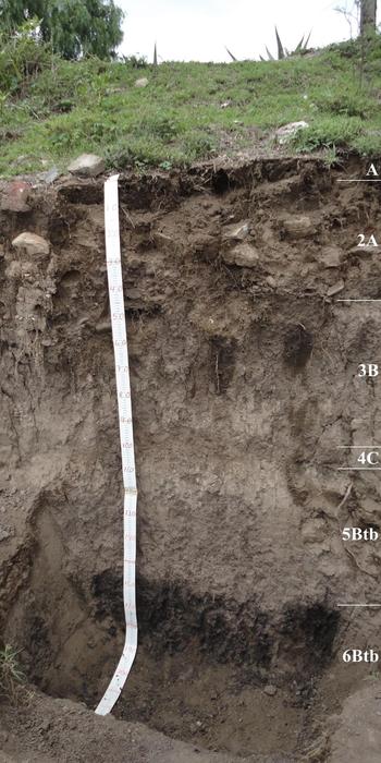
Photo of the San Lorenzo profile, showing a sequence of alluvial sediments with weakly developed soils. Note the dark horizon at the bottom, which macroscopically resembles the Black San Pablo Paleosol. Depth of sequence = 1.90 m. Photograph by McClung de Tapia.

METHODS AND MATERIALS
We sampled profiles in Compound 18:S3E1, the eastern, central, and western part of the Street of the Dead, and a soil profile exposed at the San Lorenzo river (Figures 1–4). The analyses included micromorphological studies on thin sections from block samples and botanical and soil analyses on bulk samples. We employ the terms horizon for soil horizons at the San Lorenzo profile and layers or deposits, if not differentiated into single layers, for archaeological contexts.
Micromorphology is a method to analyze formation processes of soils and sediments through the study of intact blocks of sediment that have been indurated with a polyester resin, sliced, and made into petrographic thin sections. This method allows not only the identification of sedimentary components, but also sedimentary structures, pedogenetic features, and anthropogenic formation processes, as well as their spatial and temporal relationships (Courty et al. Reference Courty, Goldberg and Macphail1989). For this study, 22 oriented-block samples were collected from the Street of the Dead (central, eastern, and western part), Compound 18:S3E1, a platform outside Compound 17:S3E1, and a soil profile at the San Lorenzo river (Figures 1–3, Table 1). Thin sections were produced by Panagiotis Kritikakis (Geoarchaeological Laboratory, University of Tübingen) and by Pedro Torres (Laboratorio de Génesis, Morfología y Clasificación de Suelos, Programa de Edafología, Colegio de Postgraduados). Analysis was conducted with petrographic microscopes under plane-polarized (PPL) and cross-polarized light (XPL) at magnifications of 6.5 to 200×. Microstructure, basic mineral and organic components, groundmass, and pedofeatures were described following concepts and terminology in Bullock et al. (Reference Bullock, Fedoroff, Jongerius, Stoops, Tursina and Babel1985), Courty et al. (Reference Courty, Goldberg and Macphail1989), Stoops (Reference Stoops2003), and Stoops et al. (Reference Stoops, Marcelino and Mees2010). For unusual technical terms, we included a description with the first use of the term.
Micromorphological descriptions from the Street of the Dead (SOTD), Compound 18:S3E1, and the San Lorenzo profile.

a Listed in order of decreasing frequency.
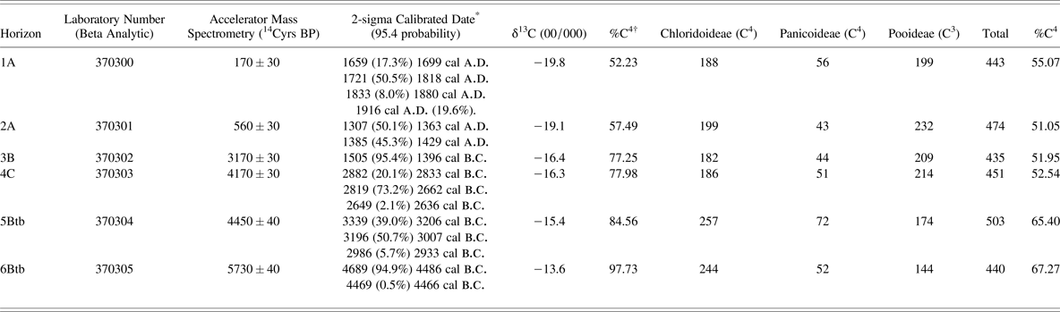
Bulk samples from the San Lorenzo soil profile were analyzed for their chemical and physical properties following the protocol of van Reeuwijk (Reference van Reeuwijk2002). This included color determination with a Munsell Soil Color Chart in dry and wet conditions, volumetric measurements, pH determination, texture, and organic and carbon content. AMS radiocarbon dates and stable carbon isotope values (δ13C) were determined in bulk sediment samples by Beta Analytic. Calibrations were carried out in OxCal 4.3.2. (Bronk Ramsey Reference Bronk Ramsey2017) using the IntCal13 atmospheric curve (Reimer et al. Reference Reimer, Bard, Bayliss, Beck, Blackwell, Ramsey, Buck, Cheng, Edwards, Friedrich, Grootes, Guilderson, Haflidason, Hajdas, Hatté, Heaton, Hoffmann, Hogg, Hughen, Kaiser, Kromer, Manning, Niu, Reimer, Richards, Scott, Southon, Staff, Turney and van der Plicht2013). Isotope values are expressed as a percent of organic material corresponding to C4 vegetation (Table 5; McClung de Tapia and Adriano-Morán Reference McClung de Tapia and Adriano-Morán2012).
Samples for pollen and phytolith analysis were obtained from the soil profile situated at the edge of the San Lorenzo river and for pollen analysis additionally from the central area of the Street of the Dead. Ten grams of sediment were collected from each soil horizon or archaeological layer. Pollen extraction was carried out using a modified acetolysis procedure at the Laboratorio de Paleoetnobotánica y Paleoambiente, Instituto de Investigaciones Antropológicas, Universidad Nacional Autónoma de México. Samples were mounted in glycerin gelatin and determined at 100× using an Olympus CX31 optical microscope. Phytolith extraction was carried out using sodium polytungstate as a heavy liquid following the protocol of Madella et al. (Reference Madella, Power-Jones and Jones1998). Samples were mounted in Canada balsam in order to facilitate rotation of phytoliths, and examined at 100×, again using an Olympus CX31 optical microscope.
RESULTS
The following presents a summary of the performed analysis for each context studied here. Detailed results can be found in Tables 1 to 5.
Tepetate
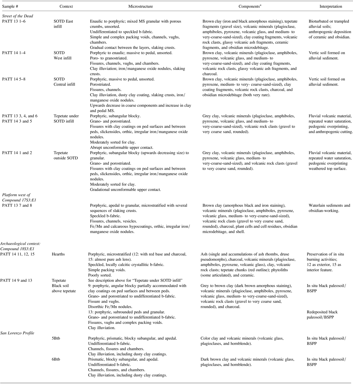
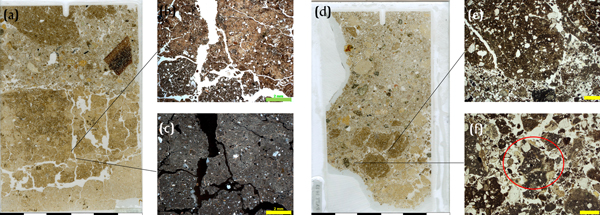
The tepetate is present in nine thin sections and shows the same characteristics in all thin sections apart from its upper boundary, which varies between the two sampled contexts, inside and outside the Street of the Dead (Figures 2 and 5, Table 1). In the field, the tepetate appeared as indurated sandy clay and had a brown (Munsell Soil Color Chart 7.5 YR 4/3) color. Under the microscope, the tepetate is very dense and has a subangular to angular blocky microstructure. Clay coatings on ped surfaces are common (Figure 5b) and slickensides (clay pressure face in groundmass resulting from repeated shrinking and swelling of the clay) also occur, but they are less common and do not occur in all samples. The tepetate is composed of gray clay with inclusions of volcanic minerals and rocks (Figures 5b and 5f). Orthic (with gradual or sharp boundaries in groundmass), irregular oxide nodules are also present (Figures 5d and 5f). There is a striking difference in the contact of the tepetate with overlying deposits inside the Street of the Dead compared to outside the Street of the Dead. Outside the Street of the Dead, in the natural context, the contact with overlying deposits is gradational unconformable with mixing of the tepetate with material from the overlying deposit (Figure 5c). Inside the Street of the Dead, in the anthropogenic context, however, the contact of the tepetate with overlying deposits is abrupt unconformable (Figures 5d and 5e).
Micromorphological observations of the tepetate and its contact with overlying deposits at the Street of the Dead. (a) Cross-polarized light (XPL) microphotograph (MP) of the natural gradational unconformable contact, exhibiting a mix of tepetate groundmass (grey areas with poro- and granostriated birefringence b-fabric) and material from the overlying layer (with a higher frequency of coarse grains and a more brownish-grey color). Scale = 5 mm. (b) XPL MP of tepetate with strong and prevalent clay coating. Scale = 0.2 mm. (c) Scan of thin section from the natural gradational unconformable contact of the tepetate with the overlying layer. Note how the boundary extends over several centimeters. Scale = 6 cm. (d) Scan of thin section from the upper surface of the tepetate in the Street of the Dead. The contact with the overlying layer is abrupt unconformable and interpreted as an anthropogenic cut into the tepetate. Also note the presence of obsidian microdebitage at the top of the slide (purple arrow). Scale = 6 cm. (e) Plane-polarized light (PPL) MP of the abrupt unconformable contact of the tepetate with the overlying brown layer. Scale = 0.2 mm. (f) PPL MP of the tepetate with iron/magnanese oxide nodules. Scale = 1 mm. Photographs by Stahlschmidt.

Infill of the Street of the Dead
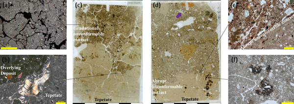
The infill deposits of the Street of the Dead, including the central, eastern, and western part, are represented in 14 thin sections and five of those are from layers immediately overlying the tepetate (Figure 2, Table 1). The deposits in the Street of the Dead are generally similar, but there are differences between the western, eastern, and central parts, as well as also for upper and lower deposits in the central part. In general, the microstructure varies between subangular blocky and granular (Figures 6b, 6e, 6g). Fissures, channels, vughs (void of irregular shape), and chambers are common (Figures 6e–6h). Coarse components are mainly volcanic minerals and rocks (Figure 6f) and, to a lesser extent, tepetate fragments (Figures 6e and 6g), charcoal, ceramic, and obsidian microdebitage (Figure 6b). Anthropogenic components are increased in number in the lower deposits compared to the upper deposits. The fine material is composed of clay with dark amorphous and iron staining. Clay illuviation (Figures 6f and 6h) and rounded, transported fragments of clay coatings were observed (Figures 6c and 6d).
Micromorphological observations of the infill sediments in the Street of the Dead from (a–d) the eastern edge and the (e, f) lower and (g, h) upper deposits at the central part. (a) Plane-polarized light (PPL) microphotograph (MP) of multilayered surface slake at the eastern edge of Street of the Dead. Note the fragmentation of the surface slack and round voids in it, the latter indicating water saturation and the former drying out and possibly trampling. Scale = 2 mm. (b) PPL MP from the eastern edge of the Street of the Dead with an obsidian fragment in the center (purple arrow). Note the open, granular microstructure, possibly a result of trampling. PPL = 1 mm. (c) Clay illuviation fragment possibly derived from earlier formed Luvisols and transported here by erosion (González-Arqueros et al. Reference González-Arqueros, Vazquez-Selem, Gama-Castro and McClung de Tapia2013; Sedov et al. Reference Sedov, Rivera and Solleiro-Rebolledo2009). PPL, scale = 0.2 mm. (d) Same as Figure 6c in cross-polarized light. Scale = 0.2 mm. Note the dissimilarity to the clay illuviation in the tepetate (Figure 5b). (e) PPL MP from the central part of the Street of the Dead showing an open to massive microstructure with many channels. Scale = 5 mm. (f) Dusty clay illuviation with microlaminations in the lower deposits in the Street of the Dead (see Figures 2a and 2b). Note also the weathering volcanic rock fragment with yellow infilling in voids (red circle), which is unlike the clay illuviation fragments in Figures 6c and 6d. PPL, scale = 0.5 mm. (g) PPL MP from an upper layer in the western edge of the Street of the Dead, showing a subangular blocky microstructure with a clayish matrix. Scale = 5 mm. (h) Clay illuviation and microdebitage (purple arrow) in the upper deposits in the central part of the Street of the Dead. PPL, scale = 2 mm. Photographs by Stahlschmidt.

There are fine differences for three characteristics for the three parts of the Street of the Dead. First, the microstructure is more open and granular at the eastern border (Figures 6a and 6b), but predominantly porphyric (dense, fine matrix with coarse components) and subangular blocky and has less voids space in the central and western part (Figures 6e and 6g). Second, waterlain depositional characteristics, such as slacking crusts (Figure 6a), are more frequent at the eastern part, while pedogenic clay illuviation (clay transported by soil moisture resulting in layers of oriented clay), some dusty (Figures 6f and 6h), are more expressed at the central and western part. Lastly, anthropogenic components, such as ceramic, charcoal, and obsidian microdebitage (Figure 6b), are much more frequent at the eastern border. Regarding the difference of the lower and upper deposits, we observed a gradual upward increase in clay and clay illuviation and an upward decrease in in coarse anthropogenic components. The microstructure is also increasingly prismatic in the upper deposits (Figure 6g).
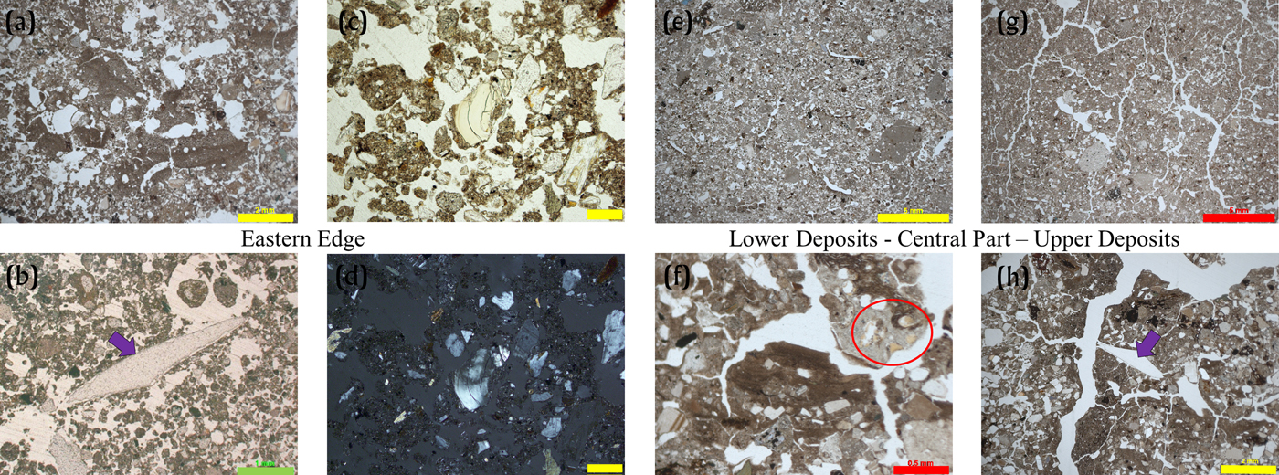
Three additional thin sections come from an excavation area between the Street of the Dead and apartment Compound 17:S3E1. Hirth and colleagues (Reference Hirth, Carballo, Dennison, Carr, Imfeld and Dyrdahl2019) suggest that this area was used for obsidian working. Deposits here consist of brown sandy to silty clay in a complex apedal (not arranged in peds) microstructure with fissures, cracks, and vughs. The birefringence-fabric (b-fabric; describes pattern and origin of interference colors in the fine material) is generally speckled but occasional calcareous hypocoatings (matrix feature related and adjoined to a surface) are also present (Figure 7d). We also observed a sequence of slacking crusts (Figure 7c). The slaking crusts contain vertical fissures, round voids (Figure 7a), and orthic irregular iron/manganese oxide nodules and hypocoatings. One slacking crust exhibits a granular microstructure (Figure 7c), possibly caused by trampling. Obsidian microdebitage occurs in each thin section in low numbers but regularly (Figures 7b and 7e). Compared to all other analyzed contexts, the number of obsidian microdebitage was highest in this context. Rare observations of obsidian microdebitage were made in the eastern and central part of the Street of the Dead. None of the samples from the western part of the Street of the Dead or the compounds contained obsidian microdebitage.
Micromorphological observations from the obsidian-working area. (a) Plane-polarized light (PPL) microphotograph (MP) of the slacking crust, showing fissures and round voids, the latter indicating water saturation and the former drying out and possibly trampling (compare to Figure 6a). Scale = 5 mm. (b) PPL MP from the lower aggregated slacking crust, indicating intense trampling of the crust. Note also the presence of obsidian here (purple arrow). Scale = 2 mm. (c) Scan of thin section PATT 13 7, showing a sequence of slacking crusts with vertical fissures, round voids and orthic, irregular iro/manganese oxide nodules and hypocoatings. Note that the lowermost slacking crust is aggregated by trampling (see Figure 7b). Scale = 6 cm. (d) Cross-polarized light MP of a calcareous hypocoating. Scale = 0.2 mm. (e) PPL MP with 3 obsidian microdebitage pieces (purple arrows). Scale = 0.5 mm. Photographs by Stahlschmidt.

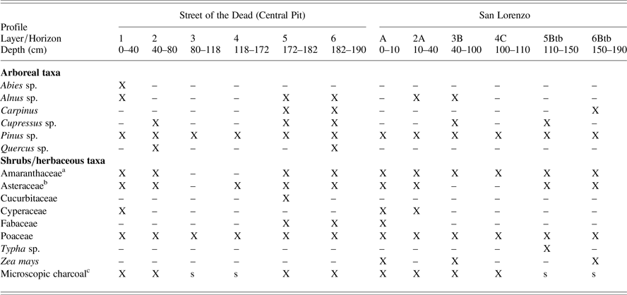
Pollen recovered from the central part of the Street of the Dead was poorly preserved, and low counts preclude construction of a suitable pollen diagram. Arboreal taxa are largely represented by pollen from genera typical of the flora in the Teotihuacan Valley (Castilla and Tejero-Diez Reference Castilla-Hernández and Tejero-Diez1987; McClung de Tapia et al. Reference McClung de Tapia, Tapia-McClung and Gorenflo2013). As expected, Pinus (pine) is present throughout both sequences, although Quercus (oak) is notably scarce. Cupressus (cypress) is restricted to the earliest levels, as is Carpinus (lechillo).
Among shrubs and herbaceous taxa, Chenopodium-Amaranthus (indicated as Amaranthaceae in Table 2) as well as Asteraceae (sunflower family) are abundant throughout, and Poaceae (grass family) are constant throughout both sequences. A possible occurrence of Zea mays (maize) was observed in layer 6. Other taxa recovered include Typha (RSL, 5Btb) and Cyperaceae (SOTD, 1; RSL, A, 2A). Betula sp. (SOTD, 5), Cuphea sp. (SOTD, 2), and Ulmus sp. (RSL, A), not reported in Table 2, are likely recent intrusions.
Pollen from the central excavation area of the Street of the Dead and the San Lorenzo profile.

a Chenopodium-Amaranthus.
b Phytoliths also present.
c Microscopic charcoal: X, abundant; s, scarce.
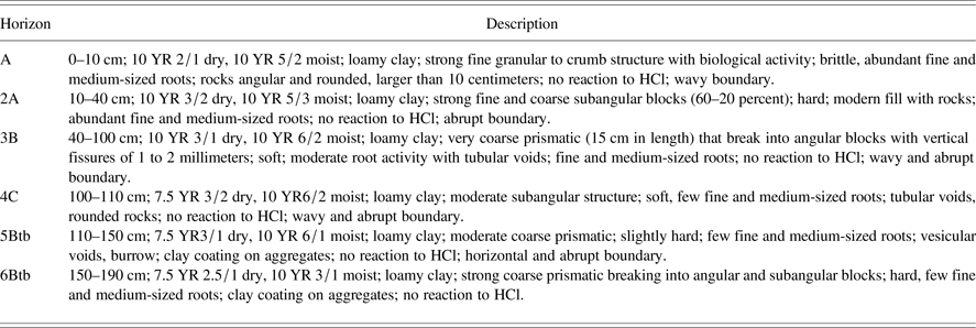
Field description of the San Lorenzo profile (following FAO 2006).

A Black Soil in the San Lorenzo Profile and in Compound 18:S3E1
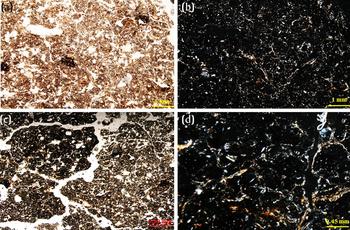
The sequence at the San Lorenzo consists of six soil horizons (Figure 4). The upper two horizons, A and 2A, show modern disturbances, and are followed by horizons developed on alluvial sediments with weak pedogenesis, horizons 3B and 4C. Of more interest here are the two lowermost horizons, 5Btb and 6Btb, and they were studied in more detail. The horizons show a marked difference of color from the upper, brown horizon 4C (7.5 YR 3/2), horizon 5Btb is grayish brown (7.5 YR3/1), and horizon 6Btb is black (7.5 YR 2.5/1; Figure 4), but they show similar chemical and physical properties with a neutral pH, moderate organic content, are composed of loamy clay (Table 4). The microstructure is blocky subangular, compact with channels, fissures and chambers (Figures 8a–8d) with a single and double-spaced porphyric coarse/fine fraction related distribution, which is characteristic of clay soils (Stoops et al. Reference Stoops, Marcelino and Mees2010). The coarse fraction is composed of volcanic minerals (volcanic glass, plagioclases, and hornblende) and the clay matrix exhibits a generally undifferentiated b-fabric, typical for volcanic soils (Sedov et al. Reference Sedov, Stoops, Shoba, Stoops, Marcelino and Mees2010). In the lower horizon 6Btb, the clay show dark brown organic staining (Figure 8c). Clay illuviation in voids is common (Figures 8b–8d), some including dusty clay coatings. Presented AMS dates for this profile (Table 5) indicate relative onset of pedogenesis, not occupation.
Micromorphological observations of horizons (a,b) 5Btb and (c, d) 6Btb at the San Lorenzo profile. (a) Plane-polarized light (PPL) microphotograph (MP) of horizon 5Btb, showing a porphyric coarse/fine fraction relation and a subangular blocky microstructure which is moderately developed. Some chambers, channels and fissures with clay illuviation are present. Scale = 1 mm. (b) Cross-polarized light (XPL) MP of horizon 5Btb, showing an undifferentiated b-fabric. Note clay illuviation in voids with moderate orientation. Scale = 1 mm. (c) PPL MP of horizon 6Btb with porphyric related distribution and subangular to angular microstructure. Fissures are interconnected and moderately accommodated. Note the dark humic staining of the ground mass. Scale = 0.59 mm. (d) XPL MP of horizon 6Btb, showing an undifferentiated b-fabric. Scale = 0.45 mm. Photographs by Gutiérrez-Castorena.

Chemical and physical analysis of the San Lorenzo profile horizon 5Btb and 6Btb.

Radiocarbon determinations, stable carbon isotope values, and phytolith data from the San Lorenzo profile.

* Calibrations were carried out with OxCal v4.3.2 (Bronk Ramsey Reference Bronk Ramsey2017) using the IntCal 13 atmospheric curve (Reimer et al. Reference Reimer, Bard, Bayliss, Beck, Blackwell, Ramsey, Buck, Cheng, Edwards, Friedrich, Grootes, Guilderson, Haflidason, Hajdas, Hatté, Heaton, Hoffmann, Hogg, Hughen, Kaiser, Kromer, Manning, Niu, Reimer, Richards, Scott, Southon, Staff, Turney and van der Plicht2013).
† Stable carbon isotope values are expressed as the percent of organic material corresponding to C4 vegetation, based on the following conversion: %C4 = (δ SAMPLE− δC3/δC4−δC3) × 100, where δ SAMPLE = δ13C value of the sample, δC3 = the mean δ13C value of C3 vegetation (−26.96‰), and δC4= the mean δ13C value of C4 vegetation (−13.29‰) in the study region (McClung de Tapia and Adriano-Morán Reference McClung de Tapia and Adriano-Morán2012). The mean values of C3 and C4 vegetation in the Teotihuacan Valley are based on Lounejeva-Baturina et al. (Reference Lounejeva-Baturina, Morales-Puente, Cabadas-Báez, Cienfuegos-Alvarado, Sedov, Vallejo-Gómez and Solleiro-Rebolledo2006).
Pollen counts at the San Lorenzo profile are low, insufficient for quantification, and reflects those at the central part of the Street of the Dead as described above (see also Table 2). The identification of Zea mays (maize) in horizon 6Btb, however, was secure at the San Lorenzo profile. Phytoliths were also recovered from at the San Lorenzo profile (Table 5). Emphasis was placed on grass phytoliths (Poaceae) from the subfamilies Chloricoideae, Panicoideae, and Pooideae to evaluate possible changes in the relative proportions of C4 and C3 taxa through time. The grass taxa in the region corresponding to the subfamily Panicoideae consist of the genus Panicum and are C4 species. Consequently, these two subfamilies are considered together.
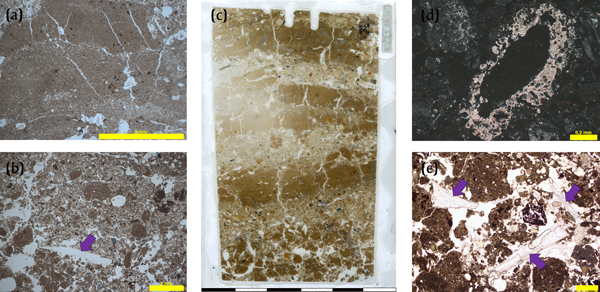
Two block samples were taken at the bottom of the south profile of Compound 18:S3E1, where a dark layer was observed overlying the tepetate (Figure 3). One sample was taken at the eastern corner of this profile (PATT 14 9; Figures 3 and 9a) and another from below Feature 36 that was dug into the tepetate (PATT 14 13; Figures 3 and 9d). Macroscopically, the black layer is rich in clay, compact, and ranged in color from black (7.5 YR 2.5/1) to very dark gray (10YR 3/1). Microscopically, the black layer is composed of dense gray to brown clay with dark humic staining (Figure 9), volcanic minerals and rocks, charcoal, and iron/manganese nodules. The b-fabric is dominantly undifferentiated and weakly grano- and porostriated (Figure 9c). The microstructure in PATT 14 9 is generally subangular with clay coating on ped surfaces and clay illuviation in voids. The black layer in PATT 14 13 shows a more mixed and open microstructure with tepetate, black soil peds, and materials from the overlying layer mixed together (Figures 9d and 9f). The peds here are generally subrounded (Figure 9e).
Micromorphological observations from the black layer overlying the tepetate in Compound 18:S3E1 (Figure 3). (a) Scan of thin section PATT 14 9 from the black soil overlying the tepetate. Note the dark humic staining of the black soil and its angular structure with interconnected fissures. Scale = 6 cm. (b) Plane-polarized light (PPL) microphotograph (MP) from PATT 14 9, showing a subangular blocky microstructure in the black soil. Note the color variance from grayish-brown to pale brown. Scale = 2 mm. (c) Same as Figure 9b in cross-polarized light, showing a weakly developed b-fabric. Scale = 2 mm. (d) Scan of thin section PATT 14 13 from the black soil overlying the tepetate in the pit below Feature 36 (Figure 3). Note that the black soil here has a mixed structure with subrounded to subangular peds of different color, composition, and size. The black soil was redeposited here. Scale = 6 cm. (e) PPL MP of a dark-brown-colored ped with a subrounded edge, indicating that this ped was transported here. Scale = 1 mm. (f) PPL MP of a tepetate fragment associated with the subrounded peds of the black soil. Note the clay coating associated with the tepetate fragment (red circle), a possible source for the clay illuviation fragments frequently observed. Scale = 0.5 mm. Photographs by Stahlschmidt.

Compound 18: Combustion Features
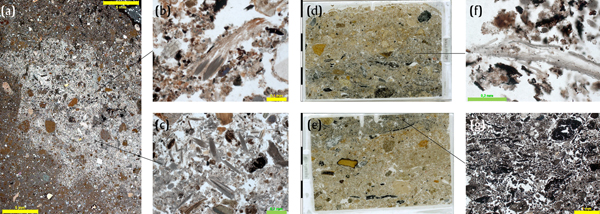
Four thin sections from two layers with combustion material were analyzed. Three thin sections, PATT 14 11, 12A, and 12B (Figures 10d and 10e; Table 1), contain a hearth/combustion features exposed in the south profile of 18:S3E1 and another thin section, PATT 14 15A, contains a white lens exposed in the east profile of 18:S3E1 (Figure 10a). All thin sections are rich in combustion residues, charcoal, ash, and phytoliths (Figures 10b and 10c, 10e and 10f). Ash and phytoliths commonly occurs clusters and are in some cased articulated (Figures 10c and 10f). Furthermore, all four thin sections show microstratification. Thin sections PATT 14 12A and B show a red base overlain by a layer dominated by charcoal and with a little ash mixed in at the top (Figures 10d and 10e). The white lens in thin section PATT 15A is dominated by ash and shows clear boundaries (Figure 10a). Natural components, such as clay, volcanic rocks, and minerals, occur in low numbers inside the combustion features.
Micromorphological observations of the hearth features in Compound 18:S3E1. (a) Composite microphotograph (MP) of a white lens observed in the southern profile. The white lens exhibits a calcitic crystallitic b-fabric and sharp borders with the surrounding matrix. Scales = 5 mm. (b) Plane-polarized light (PPL) MP of partially carbonized plant tissue with grey and brown parts in the white ash lens. Scale = 0.1 mm. (c) PPL MP with elongated ashes in the white ash lens. Scale = 0.2 mm. (d and e) Thin-section scans from block sample PATT 14 12, showing a typical hearth structure—red base overlain by a microlayer dominated by charcoal and a thin, slightly ashier top—surrounded by pale-brown sediment with unstructured combustion remains, e.g., charcoal and burnt bone. Scale = 6 cm. (f) PPL MP of articulated phytoliths from the ash-dominated top in Figure 10d. Scale = 0.2 mm. (g) PPL MP of the charcoal dominated microlayer in Figure 10e. Scale = 1 mm. Photographs by Stahlschmidt.

DISCUSSION
Formation and Alteration of the Tepetate
Our micromorphological observations on the tepetate mainly resemble those made in other studies and support the interpretation of the tepetate as a fluvial deposit of volcanic material with pedogenic overprinting (e.g., Gutiérrez-Castorena et al. Reference Gutiérrez-Castorena, Oritz-Solorio and Sánchez-Guzmán2007; McClung de Tapia et al. Reference McClung de Tapia, Solleiro-Rebolledo, Gama-Castro, Villalpando and Sedov2003; Rivera-Úria et al. Reference Rivera-Úria, Sedov, Solleiro-Rebolledo, Pérez-Pérez, McClung de Tapia, González and Gama-Castro2007; Solleiro-Rebolledo et al. Reference Solleiro-Rebolledo, Sedov, Gama-Castro, Román and Escamilla-Sarabia2003; Williams Reference Williams1972). Pedogenic overprinting occurred in two stages. First, shrinking and swelling lead to a prismatic microstructure and local formation of slickensides (vertization). Second, percolating water transported clay filling up the fissures (argilluviation), which indurated the tepetate and made it less water permeable, leading to redoximorphic features. We did not observe carbonate accumulation in the tepetate, however, in contrast to other studies (Rivera-Úria et al. Reference Rivera-Úria, Sedov, Solleiro-Rebolledo, Pérez-Pérez, McClung de Tapia, González and Gama-Castro2007; Solleiro-Rebolledo et al. Reference Solleiro-Rebolledo, Sedov, Gama-Castro, Román and Escamilla-Sarabia2003), which may indicate that this is local phenomenon.
Regarding the upper boundary of the tepetate, we observed a twofold microstructure. The natural contact of the tepetate with its overlying deposits is gradational unconformable and exhibits a mix of materials. In contrast, the contact at the lowered and sloping part in the Street of the Dead is abrupt unconformable with hardly any mixing of materials between the deposits. We interpret these contrasting contacts as the result of different formation histories of the two contexts. At the natural contact, the exposed and weathered surface of the tepetate is present. The abrupt contact at the lowered and sloping part inside the Street of the Dead is the result of people cutting into the tepetate. Our results support Paddock's (Mexico City Collegian, August 24, 1962:4–5, cited in Millon Reference Millon1973:38) postulation that the southern Street of the Dead was excavated into the tepetate. The excavation of the tepetate would have necessitated a substantial work effort and reflects on neighborhood organization (see discussion in Carballo et al. Reference Carballo, Hirth, Sariñana, Buckley, Ramón and Kennett2019).
Infill History of the Street of the Dead
Our analysis shows that the infill of the Street of the Dead is predominantly natural and composed of vertic soil horizons formed on alluvial sediments. Upper deposits show an increase in clay and a decrease in coarse materials, possibly reflecting a reduced energy setting as the Street of the Dead filled up with sediments. Solleiro-Rebolledo et al. (Reference Solleiro-Rebolledo, Sycheva, Sedov, McClung de Tapia, Rivera and Salcedo-Berkivich2011) and González-Arqueros et al. (Reference González-Arqueros, Vazquez-Selem, Gama-Castro and McClung de Tapia2013) observed a pattern of upland erosion and lowland sedimentation in the Teotihuacan Valley that would have provided sediments for the infill of the Street of the Dead after its abandonment. Similar to our micromorphological study, Sedov et al. (Reference Sedov, Rivera and Solleiro-Rebolledo2009) as well as González-Arqueros et al. (Reference González-Arqueros, Vazquez-Selem, Gama-Castro and McClung de Tapia2013) observed fragments of pure clay in the weakly developed soils of this area. They interpreted these as illuvial pedofeatures derived from earlier formed Luvisols and as evidence for erosion. We also observed similar fragments of pure clay coating and also observed such pure clay coatings forming inside the tepetate (Figure 5b), confirming the earlier interpretations of erosion.
We observed an interesting microstratigraphic pattern in the infill of the eastern border of the Street of the Dead compared to its central and western part. The eastern border contains a wall structure with a collapse layer and here microscopic anthropogenic components and processes are more common than in the central and western parts. The granular microstructure and the fragmentation of graded bedding structures may results from bioturbation or trampling. The slaking crusts in the possible obsidian area also shows fracturing and, in one instance, a granular expression. The association with anthropogenic components, structures, and activities makes trampling a likely source for the granular microstructure. Similar trampling interpretations have been made in experimental (Rentzel and Narten Reference Rentzel and Narten1999) and archaeological studies (Miller et al. Reference Miller, Conard, Goldberg and Berna2010) and indicate the regular use of the Street of the Dead. There is, however, a curious scarcity of microscopic anthropogenic remains in the deposits directly overlying the tepetate inside the Street of the Dead. Gé et al. (Reference Gé, Courty, Matthews, Wattez, Goldberg, Nash and Petraglia1993) suggest that a microscopic layer (“active zone”) forms upon occupation surfaces as a result of use of the surface. The absence of this microlayer can be the result of anthropogenic cleaning/maintenance activities of the tepetate surface or of natural erosive processes, e.g., rain water draining the southern extension of the Street of the Dead (Carballo et al. Reference Carballo, Hirth, Sariñana, Buckley, Ramón and Kennett2019). There is no microstratigraphic evidence for either of these two models, the deposits have been homogenized by trampling and/or bioturbation, which in itself may have erased this anthropogenic microscopic layer.
Our analysis further support obsidian working outside Compound 17:S3E1 in the West Platform between the compound and the Street of the Dead (Hirth et al. Reference Hirth, Carballo, Dennison, Carr, Imfeld and Dyrdahl2019). Obsidian microdebitage shows a constant presence in all thin sections from the excavation area west of Compound 17:S3E1 and it also regularly occurs at the eastern border of the Street of the Dead and only rarely in the central part. No obsidian microdebitage was observed at the western part of Street of the Dead, however, or inside Compounds 17:S3E1 and 18:S3E1. The absence of obsidian microdebitage in Compounds 17:S3E1 and 18:S3E1 could be the result of cleaning activities. Microdebitage is commonly trampled into floors, however, thus becoming embedded in even swept floors and future micromorphological studies on the floor constructions in the apartment compounds will investigate this question. Based on our current dataset, we instead interpret the absence of microdebitage to indicate that no obsidian working occurred inside the compounds. The occurrence of obsidian microdebitage in deposits that show no evidence of redeposition supports the presence of obsidian production in the periphery of the city, meaning that resident commoners would have exchanged this valuable export commodity (Hirth et al. Reference Hirth, Carballo, Dennison, Carr, Imfeld and Dyrdahl2019).
A Black Soil in the San Lorenzo Profile and in Compound 18:S3E1
Black layers and horizons overlying the tepetate studied here generally resemble the BSPP presented in other studies, but there are some differences. Shared characteristics are the macroscopically dark color, which is caused by dark humic staining of the clayish groundmass, the clayish matrix, presence of volcanic minerals, clay illuviation in voids, and the angular to subangular blocky microstructure (González-Arqueros et al. Reference González-Arqueros, Vazquez-Selem, Gama-Castro and McClung de Tapia2013; Rivera-Úria et al. Reference Rivera-Úria, Sedov, Solleiro-Rebolledo, Pérez-Pérez, McClung de Tapia, González and Gama-Castro2007; Sánchez-Pérez et al. Reference Sánchez-Pérez, Solleiro-Rebolledo, Sedov, McClung de Tapia, Golyeva, Prado and Ibarra-Morales2013; Sedov et al. Reference Sedov, Rivera and Solleiro-Rebolledo2009; Solleiro-Rebolledo et al. Reference Solleiro-Rebolledo, Sycheva, Sedov, McClung de Tapia, Rivera and Salcedo-Berkivich2011). One other interesting micromorphological observation was the occurrence of dusty clay coatings (see also McClung de Tapia et al. Reference McClung de Tapia, Solleiro-Rebolledo, Gama-Castro, Villalpando and Sedov2003), which have been interpreted as evidence for agricultural activities (Jongerius Reference Jongerius1970). More data on their occurrence in other profiles is needed, however, to assess if they indeed reflect agricultural activities or instead result from natural processes. There are also some differences in the black soils studied here compared to the BSPP presented in other studies and also between the black soils studied here. For one, the black layer below the dug-in pit in Compound 18:S3SE1 (PATT 14 13) shows a subrounded blocky microstructure and is locally granular. We interpret the black layer in this specific location as redeposited into the pit Feature 36. The nearby sample PATT 14 9, next to the pit, however, contains an in situ formed black layer/soil. Further, and in contrast to other studies, we did not observe carbonate accumulation in the tepetate or the black soils apart from the redeposited black layer below the dug-in Feature 36. In this latter context, however, the source of the carbonate is most likely the combustion features above (see section Hearth Features Compound 18:S3E1). Lastly, the black soil at San Lorenzo does not exhibit vertic features, which were observed to a variable extent and expression in the other black soils.
This comparison shows that, while the BSPP is widely distributed throughout the Teotihuacan Valley, its expression varies locally from a micromorphological view point. At Compound 18:S3E1, this variation is largely due to its anthropogenic context. Nonetheless, the evidence for the broad distribution of the BSPP with its different expressions throughout the Teotihuacan Valley calls into question earlier views of potential agricultural productivity, calling for caution in estimates based on modern soils (McClung de Tapia Reference McClung de Tapia, Cooper and Sheets2012; Sánchez-Pérez et al. Reference Sánchez-Pérez, Solleiro-Rebolledo, Sedov, McClung de Tapia, Golyeva, Prado and Ibarra-Morales2013; see section Paleoenvironmental Reconstruction).
Hearth Features Compound 18:S3E1
Micromorphological analyses of the analyzed layers with combustion materials in Compound 18:S3E1 demonstrate their in situ character. This interpretation is based on their microstratigraphy, in situ broken charcoal, the occurrence of articulated ashes and phytoliths. These features all indicate an in situ preserved burning event (Mentzer Reference Mentzer2014; Sherwood Reference Sherwood2001). The difference in the composition of the two combustion features, mostly charcoal in the hearth feature and mostly ash in the ash lens, could result from higher or more continuous burning for the ash lens compared to the hearth feature. This contrasting composition of the features, however, may also be related to different preservation conditions in the two contexts. The clear borders of the white ash lens and the lack of dissolution traces indicate that this is an interior feature. The hearth feature, on the other hand, is less distinct and little ash is present/preserved. Calcareous hypocoatings below the feature indicate dissolution of calcareous materials, e.g., by acid rain, followed by downward transport and recrystallization as hypocoatings. We propose that the hearth feature is, in fact, an exterior feature.
Informal hearths are not typical features of Teotihuacan apartment compounds, and it is possible that the use of ceramic stoves called three-pronged burners was an adaptation suited to indoor cooking in densely occupied compounds (Rattray Reference Rattray2001). The studied hearth feature may stem from earlier, non-apartment dwellings, or from outside house-lots underlying Compound 18 (Carballo et al. Reference Carballo, Hirth, Sariñana, Buckley, Ramón and Kennett2019). Hearths were also observed in a 2 × 2-m test excavation by the Teotihuacan Mapping Project at an apartment compound at Tetitla, including the Late Tlamimilolpa levels. Here, it was not possible to determine whether they were interior or exterior features (Emily McClung de Tapia, personal observation 1974). The documentation of small, informal hearths at Tlajinga in both areas where excavations reached early occupation layers at 18:S3E1 provides additional evidence of a different type of residence preceding the apartment compounds in this area.
Paleoenvironmental Reconstruction
Pollen counts at the central part of the Street of the Dead and the San Lorenzo profile are low, resulting from the dynamic of erosion and deposition in this area, compounded by frequent inundations in the case of RSL. This is at least partially a consequence of hydric and mechanical action as the sediments were redeposited, initially over the tepetate surface of the avenue, and during subsequent depositional events. A comparison of taxa recovered from the Street of the Dead and the San Lorenzo profile highlights the predominance of characteristic flora associated with the anthropogenic landscape of the region and suggests parallel erosive dynamics (Table 2).
The BSPP is generally believed to have developed under semi-arid conditions during a period of mid-Holocene landscape stability (González-Arqueros et al. Reference González-Arqueros, Vazquez-Selem, Gama-Castro and McClung de Tapia2013; Sánchez-Pérez et al. Reference Sánchez-Pérez, Solleiro-Rebolledo, Sedov, McClung de Tapia, Golyeva, Prado and Ibarra-Morales2013; Solleiro-Rebolledo et al. Reference Solleiro-Rebolledo, Sycheva, Sedov, McClung de Tapia, Rivera and Salcedo-Berkivich2011). AMS determinations on bulk organic sediment from RSL (Table 5) are consistent with this appraisal, indicating that evidence for pedogenesis in the southern sector of the Teotihuacan is somewhat earlier in the Tlajinga area, 4689–4466 cal b.c. (located south of San Lorenzo river), with respect to La Ventilla, 3960–3797 cal b.c. (north of San Lorenzo river; Sánchez-Pérez et al. Reference Sánchez-Pérez, Solleiro-Rebolledo, Sedov, McClung de Tapia, Golyeva, Prado and Ibarra-Morales2013). Semiarid conditions in the region are also supported by several reconstructions of precipitation trends that stress the impact of frequent drought in the region and on the inhabitants of Teotihuacan (Lachniet et al. Reference Lachniet, Bernal, Asmerom, Polyak and Piperno2012; Stahle et al. Reference Stahle, Diaz, Burnette, Paredes, Heim, Fye, Soto, Therrell, Cleaveland and Stahle2011). In the same line, our comparison of δ13C values, converted into percentages of C4 plants (Table 5), with the percentages of C4 phytoliths recovered from the San Lorenzo profile are also consistent with essentially semi-arid conditions (Table 5). The lower percentages of C4 phytoliths, however, reflect an increased presence of pooid phytoliths associated with higher humidity related to runoff from cooler, more humid forest soils in the Patlachique range, inundations from the San Lorenzo river, and irrigation networks in the alluvial plain of Tlajinga. Also, Carpinus and Typha are both likely indicators for more humid conditions associated with riverbank and adjacent floodplain areas. The δ13C values associated with horizons 5Btb and 6Btb undoubtedly reflect maize cultivation and this has also been documented in the black soil at Rio San Pablo (Sánchez-Pérez et al. Reference Sánchez-Pérez, Solleiro-Rebolledo, Sedov, McClung de Tapia, Golyeva, Prado and Ibarra-Morales2013). The presence of Zea mays (maize) pollen, particularly in 6Btb/VI at San Lorenzo supports this notion.
CONCLUSION
Sediments in the Tlajinga district of Teotihuacan serve as archives of the district's inhabitants and paleoenvironments. Apart from the numerous construction materials, the Tlajinga people left hearths and microscopic remains of obsidian-working and maize-cultivation behind. Moreover, they undertook the great effort to cut into the local bedrock, the tepetate, to build the southern extension of the Street of the Dead. These traces reflect on the investment and importance of the Tlajinga district, as well as on its change over time.
The occurrence of San Pablo Paleosol below archaeological contexts and exposed along the San Lorenzo river gives insights into past agricultural potentials of the region, which now appear much greater than previously thought, while botanical investigations support semi-arid conditions in the region. AMS determinations and δ13C values presented here complement the radiocarbon chronology and stable carbon isotopes of Rio San Pablo and La Ventilla and together will permit the establishment of a more detailed picture of the interaction between climate and human impact in the pre-Hispanic Teotihuacan Valley.
RESUMEN
La investigación geoarqueológica llevada a cabo en el distrito de Tlajinga, Teotihuacán considera la reconstrucción del entorno y el comportamiento humano representados en las excavaciones del Proyecto Arqueológico Tlajinga Teotihuacán (PATT). Se estudiaron cuatro contextos diferentes: la extensión sur de la Avenida de los Muertos, un posible taller de obsidiana fuera del conjunto 17:S3E1, una capa negra superpuesta al sustrato de tepetate así como una capa asociada con combustión en el conjunto 18:S3E1, y un perfil edáfico a la orilla del Río San Lorenzo. Se usó micromorfología, análisis de polen y fitolitos, y análisis de suelos a los depósitos de dichos contextos. Los análisis permitieron la reconstrucción de algunos aspectos del comportamiento humano: nivelación de la superficie de la Avenida de los Muertos, trabajo de obsidiana afuera del conjunto 17, combustión in situ debajo del conjunto 18. Además, se consideraron características paleoambientales, incluyendo el relleno aluvial de la Avenida de los Muertos con evidencia de pedogénesis poco desarrollada, y la presencia y variabilidad del paleosuelo negro de San Pablo y su uso agrícola.
ACKNOWLEDGMENTS
We would like to thank the excavation team of the PATT project and David Carballo for inviting us to the project. PATT research reported here was supported by a grant to Carballo from the National Science Foundation (BCS-1321247) and authorized by the Mexican Instituto Nacional de Antropología e Historia (INAH). Stahlschmidt would like to thank the Athene program and Geoarchaeological Working Group of the University of Tübingen as well as the University College Dublin School of Earth Sciences for research support. McClung de Tapia received funding from CONACyT 101988. Diana Martínez-Yrizar, Carmen Cristina Adriano-Morán, and Emilio Ibarra-Morales (IIA_UNAM) participated in the analysis of macro- and microbotanical remains. We are grateful to these institutions and to the people of San José Tlajinga for their support. Lastly, we want to thank two anonymous reviewers and David Carballo for their helpful comments on the manuscript.