

The Nanzhao Kingdom (c.738–902 CE) separated Tang China and the Tibetan Empire from Southeast Asian states. The topography, ecology and ethnic composition southwest and southeast of the lacustrine basins of Erhai and Dian in western and central Yunnan marked the northern extent of Mainland Southeast Asia at this time. This vast region constituted part of the fluid zone where the cultures of Han/Confucian China and greater Southeast Asia had interacted since 221 BCE, but the influence of the former remained weak during the eighth and ninth centuries.Footnote 1 Cartographical reconstructions show Nanzhao's administered territory extending into northern Myanmar, Thailand and Laos (see Map 1). However, as Grant Evans perceptively pointed out, despite being among the largest states in contemporary Mainland Southeast Asia, Nanzhao is not recognised as having played a role in Southeast Asian history;Footnote 2 it is not included in major historical narratives, and specialist studies only mention it perfunctorily.Footnote 3 This lack of inclusion is all the more surprising because the Nanzhao Kingdom; its successor state, the Dali Kingdom; and the Mongol-Yuan all threatened the Pyū and Pagan kingdoms from the ‘front door’ on Myanmar's northern frontier.Footnote 4
Walled-cities in the Upper Ayeyarwady and Upper Mekong
Notes: Most of the 16 important walled-cities in the Upper Ayeyarwady were situated on routes leading to the river, with two cities and one fort on the west bank at the Shenlong River 神龍河. The position of (15) Zhuge Liang 諸葛亮城 (today's Longling 龍陵) and (10) Suole 些樂城 (today's Ruili 瑞麗) strongly suggests that there was an overland route into the Pyū Kingdom from today's Ruili basin. Nanzhao maintained access to the Ayeyarwady from the walled-cities of the Five Circuits (wudao 五道) at (6) Lishui 麗水城 (also known as Xunchuan Dachuan cheng 尋傳大川城), (2) Changbang 長傍城, (8) Moling 摩零城, (4) Jinbao 金寶城, and (7) Mi 彌城, which administered local Tibeto-Burmese and Mon-Khmer speakers. In contrast, the upper Mekong had fewer walled-cities, only seven, and none positioned deep in the territory of the ten tribes of the Heichi and other stock which extended south along the east bank of the Salween River down to Mueang Sat, east to Chiang Rai and then across to Luang Phrabang and beyond. Nanzhao placed less weight on communication with Dvāravati and Angkor than with the Upper Ayeyarwady, which connected the Lake Erhai area with India and the Pyū Kingdom.
Source: Extent of Nanzhao administration is based on Tan Qixiang 譚其驤, ed., Zhongguo lishi ditu ji 中國歷史地圖集 [The historical atlas of China] (Shanghai: Ditu chubanshe, 1982), vol. 5, pp. 80–81, and the location of walled-cities from Fang Guoyu, Zhongguo xinan lishi, pp. 472–92.

Historians have described Nanzhao as a state influenced by Tang China.Footnote 5 This focus has diverted scholarly attention away from investigating the commonalities it shared with coeval Southeast Asian states such as Pyū, Champa, Dvāravati, Angkor and Pagan. Historians of Southeast Asia lost interest once scholars proved that Nanzhao was not a Tai polity and had no association with the origin of Tai ethno-linguistic stock. In 2014, Grant Evans argued that Nanzhao was a variant ‘classical kingdom’ of Mainland Southeast Asia for the following reasons:
• It was among the first Buddhist kingdoms of ancient Southeast Asia, preceded only by the Pyū state. Nanzhao/Dali adopted the ideology of kingship centred on rule by a cakravartin, who integrated diverse peoples in his role as a universal monarch.
• Its destruction of the northern Pyū aided the in-migration of proto-Burmese and ushered in the Pagan kingdom.
• It led military campaigns against Annam (Red River basin in North Vietnam) c.860–866 and expeditions against Angkor and other polities in the Mainland.Footnote 6
However, Evans' criteria are insufficient to define the Southeast Asian nature of Nanzhao political organisation. There is no conceptualisation of Nanzhao/Dali kingship within the ideology of Southeast Asian Buddhist kingdoms, or a clear definition of the term ‘classical kingdom’. The disruption caused by the military expeditions into today's Myanmar and Thailand for plunder and manpower in typical Southeast Asian style alone does not qualify Nanzhao as a Southeast Asian kingdom.
This article sets out to demonstrate the Southeast Asian nature of Nanzhao as a Sinitic state similar to Dai Viet by examining how Nanzhao expanded governance south into the Upper Ayeyarwady and Upper MekongFootnote 7 river regions. Previous studies have argued that the expansionary policies of Geluofeng 閣羅鳳 (r. 748–779), the fifth monarch, strengthened the Nanzhao Kingdom vis-à-vis Tang China and Tibet and emphasised the heavy influence exerted by Tang China on its political organisation.Footnote 8 I argue that it was the combination of a Sinitic-style bureaucracy, and indigenous Southeast Asian allegiance ties that enabled Geluofeng to broaden Nanzhao's entire power base. I begin by conceptualising Nanzhao as a Sinitic state within the broader framework of Southeast Asian classical kingdoms. Next, I trace the long process of Nanzhao expansion into the Upper Ayeyarwady and the Upper Mekong, and the way the elite invoked the Confucian civilisation narrative to justify it. Then I demonstrate how the state consolidated power through forced migration, and finally cite the case of northern Mon-Khmer speakers to show the pattern of permanent governance over ethnic peoples at the periphery.
Nanzhao as a Sinitic state in early Southeast Asia
The term ‘classical kingdoms’ refers to Southeast Asia's first great states of Pagan, Angkor, Dai Viet, Srivijaya and Majapahit, which flourished roughly between the ninth and the fourteenth centuries CE. These states emerged in response to influences from Indian and Chinese civilisation, but in tension with indigenous/local elements.Footnote 9 In his discussion of the analytical framework for these kingdoms, Michael Aung-Thwin referred to the exogenous nature of the term ‘classical kingdoms’, pointing out that it rewords the earlier colonial label ‘Indic’ kingdoms, which described polity building through the Hinduised concept of the universal monarch and its accompanying ideological apparatus. He also emphasised the Euro-centric bias of postulating a ‘golden age’ akin to ancient Greece and Rome.Footnote 10 Victor Lieberman honed the framework of historical continuity with modern nation-states by re-labelling classical kingdoms as ‘charter states’; the political, administrative, and religious charters of each polity defined the nature of their successor states, aiding long-term political, social and ethnic integration down to the present.Footnote 11 This construct links the pedigrees of classical kingdoms/charter states to modern nation-states, and conveniently dovetails with orthodox national narratives by tracing the origin of nation-states back to a primary polity (‘golden age’), Myanmar to Pagan, Cambodia to Angkor, Vietnam to Dai Viet, and Thailand to Sukhothai. However, this scenario excludes kingdoms without successor states like Champa, Dvāravati, Nanzhao and Dali (937–1253 CE) on the grounds that they failed to progress along the trajectory to modern nation-statehood. The ‘charter’ of Nanzhao and its successor state, the Dali Kingdom, ended in 1276 with the incorporation of its territory into the newly founded Chinese province of Yunnan by the Mongol-Yuan. After the conquest of 1382, Ming China obliterated the Nanzhao-Dali heritage in its transformation of local society, culture and religion to fit the new norm.Footnote 12 The exclusionism inherent in the classical kingdoms/charter states construct hinders our recognition of the important role played by these two kingdoms in Southeast Asian history between the eighth and thirteenth centuries.
Treating Yunnan as a northern extension of Southeast Asia, this article argues that Nanzhao was a Sinitic state with the characteristics of a Southeast Asian classical kingdom like Dai Viet. By Sinitic state, I mean an indigenous polity in which the rulers selectively borrowed, adapted and localised exogenous elements from Chinese civilisation to reshape and integrate their multi-ethnic societies into a new political and cultural system. Salient features shared by both Dai Viet and Nanzhao include:
• Localisation and internalisation of Chinese cultural elements. By combining pre-Sinitic local culture with Sinitic elements rulers managed to integrate diverse ethnic groups into their regimes. In the case of Dai Viet, integration reached the point that the alien origins of these elements ‘became irrelevant’, turning them into a convenient tool for reshaping local identities to suit new polities.Footnote 13
• Though the influence of Confucianism remained restricted to officials, the state adopted the civilised–uncivilised binary.Footnote 14
• Close connection of the state with Chinese-style Mahayana Buddhism rather than Theravada. Evidence for Nanzhao/Dali kings as cakravartins adopting the ideological apparatus of Mahayana Buddhism to support their claims to ritual and political supremacy did not appear until the later ninth century at the earliest.Footnote 15
Dai Viet was characterised by aristocratic leadership, a decentralised, yet partially literate political organisation, and Buddhist-dominated religious syncretism. It did not achieve unified governance; the Ly dynasty only directly controlled several of the Vietnamese-speaking regions that retained a high degree of autonomy during the tenth century.Footnote 16 By contrast, Nanzhao established a centralised bureaucracy modelled on the Tang governance system with literary Sinitic as the language of the bureaucracy, and maintained political stability by appointing local ethnic leaders to senior positions in the bureaucracy, and did not recruit bureaucrats through an examination system. Though the administrative structure of Nanzhao displayed a higher level of political centralisation than the Ly and Tran dynasties, polities coeval with the Dali Kingdom,Footnote 17 Nanzhao's rulers retained the pre-Sinitic practice of relying on ties of allegiance with powerful ethnic leaders for the appointment of provincial officials and military commanders.
Like the classical Southeast Asian kingdoms, Nanzhao encompassed an assortment of ethnicities. It emerged as a unified state from the southernmost polity of Mengshe Zhao 蒙舍詔 when it conquered the five (or seven) other polities located in the Lake Erhai core area of western Yunnan c.738. No regime had been powerful enough to merge them into a single polity before the conquest by Piluoge 皮羅閣 (r. ?–748), the ruler of Mengshe. Tang China's investiture of Piluoge as the Yunnan king 雲南王 after the conquest legitimised his position as the monarch of the Nanzhao Kingdom. The ethnic composition of the core area comprised Wu Man (Black Barbarian) and Bai Man (White Barbarian) populations.Footnote 18 The ruling strata of Mengshe and some other core area polities were Wu Man, while Bai Man made up the bulk of the population. Little is known about these ethnic categories other than that the Bai Man were relatively close to Sinitic culture in lifestyle and language while the Black Barbarians distanced themselves from Sinitic culture, living in mountain forests.Footnote 19 By the middle of the eighth century the king of Nanzhao relied on a council of chief ministers (qingping guan 清平官), some of whom concurrently held positions as great generals (dajunjiang 大軍將) and served as regional administrative heads. The Six Sections (liucao 六曹), which may have corresponded to Tang China's Six Ministries (liubu 六部), handled routine administration.Footnote 20 The king bestowed the prestigious title of notable leader (qiuwang 酋望) on Bai Man ‘tribal chiefs (buqiu 部酋)’ in the core area,Footnote 21 a practice which highlights the multi-ethnic composition of the ruling strata. With the king standing at the apex of the civil and military organisation of government, these titles must have consolidated royal authority by deepening bonds with the politically prominent Bai Man.
Chinese historians endeavour to link the genesis of the Bai nationality 白族 with the Bai Man of the Nanzhao and Dali kingdoms. This resembles Southeast Asian historians projecting the national identity of the Khmers back to Angkor, the Burmans to Pagan, and the Vietnamese to Dai Viet, the principal difference being that Chinese historians trace the Bai to a ‘local regime’ (difang zhengquan 地方政權), not a modern nation-state. Lin Chaomin argues that the Bai formed through the gradual integration of different ethnic groups in the Lake Erhai core area after the re-naming of Nanzhao as Da Fengmin Guo (Great Vassal People State) c.877.Footnote 22 The practice of assigning today's ethnic groups to ancient designations is risky because it is difficult to verify the continuum of referents over time. Tracing the creation of the Bai as an ethnic group is particularly complicated because the fall of the Dali Kingdom in 1253 altered their position within the Sinitic framework of the civilised–uncivilised binary. Hou Chong maintains that Bai ethnic consciousness and supporting legends appeared in response to the Ming conquest.Footnote 23 Megan Bryson argues that finding themselves now categorised as barbarians in the Ming civilising project, local elites at Dali ‘began to represent themselves as “Bai” in a way that seems to fit into ethnic discourse’ during the fifteenth and sixteenth centuries.Footnote 24 Leaving aside the issue of Bai genesis, it is striking that many scholars conceptualise Nanzhao as an integrative force moulding new ethnic culture at the kingdom's core.
The geo-political importance of Yongchang
The extension of Nanzhao governance into the Upper Ayeyarwady and Upper Mekong did not suddenly start in the mid-eighth century. It was part of a longer process beginning with the conquest of the strategically positioned Yongchang earlier between 713 and 728. Therefore, I must make a digression to elucidate this background to put Nanzhao's expansion south in the mid-eighth century into chronological perspective and further highlight, in contrast to the other polities at the core, ancestral ties that the Wu Man of Mengshe claimed with southern areas.
One factor contributing to Mengshe's success in the unification of c.738 was its position as the polity closest to Yongchang.Footnote 25 Shengluopi 盛羅皮 (?–728), the third Nanzhao monarch, expanded into Yongchang first by establishing the walled-city of Zheyu 柘俞城 (later known as Yongchang 永昌城)Footnote 26 between 713 and 728. This establishment paved the way for Geluofeng's campaigns into the Upper Ayeyarwady during the mid-eighth century.Footnote 27 Next, Shengluopi subjugated the Wangjuzi Man 望苴子蠻, a northern Mon-Khmer speaking sub-group of the Puzi Man 撲子蠻 residing from Pu Dan (southeast of today's Weishan) to Tengchong on the west bank of the Salween.Footnote 28 The Puzi Man came to constitute a key part of the Nanzhao army and possibly comprised part of the 10,000 soldiers, equivalent to one-third of the Nanzhao army, permanently stationed at Yongchang.Footnote 29 Shengluopi's power base at Yongchang bolstered Mengshe's military for the conquest of the Lake Erhai area and aided Geluofeng's ‘soothing of the submitters with gentle virtue (roufu 柔服)’ recorded in the next section.
The sixth monarch, Yimouxun 異牟尋 (r. 779–808), reported in a letter to the Tang that his ancestors hailed from the Ailao Kingdom 哀牢國 and had dwelt in Mengshe ‘for generations as great commanders (jushuai 渠帥)’.Footnote 30 The Yongchang and Lincang regions were home to this fabled kingdom, which appears in the legends of ethnic peoples in Southeast Asia and China. When Shengluopi established Zheyu, he advanced into a land with which he claimed historical and cultural ties.
Yongchang encompassed a larger area in Nanzhao times than it did in the post-thirteenth century period. It extended from the west bank of the Salween to the east bank of the Mekong and from the northwesternmost point of the Kachin state where the Great Snow Mountains 大雪山 form a natural boundary with Tibet down to the Wa states of Myanmar in the south. Basins in Yongchang constituted a broad transitional zone separating the Lake Erhai core area (c.2,000 metres) from the lower elevated basins (c.300–1,000 metres) overlapping with today's Myanmar, Laos, Thailand and Vietnam.
Measuring ‘3,000 li from east to west, and 4,600 li from north to south’,Footnote 31 the Ailao Kingdom's territory extended down the Ayeyarwady towards the Indian Ocean, sprawling in a west–east direction from the Upper Ayeyarwady through Yongchang and Lincang to Sipsong Panna.Footnote 32 The Ailao Kingdom served as a hub for communication routes with India and other parts of Southeast Asia.
This kingdom boasted a large population. According to the Hou Hanshu (compiled from 398–445 CE), the territory of the Ailao king, Liu Mao, encompassed 77 village kings (yi wang 邑王) with 51,890 households totalling 553,711 people at the time of submission to the Eastern Han in 69 CE.Footnote 33 The Huayang Guozhi described Ailao as a multi-ethnic polity populated by peoples known as the Min Pu 閩濮, Jiu Liao 鳩僚, Piao Yue 僄越, Luo Pu 裸濮 (Naked Pu) and Yuandu 身毒 (Indians) and recorded that the great commanders (jushuai) of some were known as ‘kings’ (wang 王).Footnote 34 Therefore, the Ailao Kingdom comprised numerous smaller villages based in political units allied to a paramount ruler. The Indian population testifies to its contact with India, insinuating trade links. Yet from the Sinitic perspective, Ailao was an un-contacted polity.
Polities in the Lake Erhai core area could utilise their proximity to the Tang to regulate and profit from overland trade with India and Southeast Asia. Sakurai Yumio classified Nanzhao as a ‘trade route-controlling state (sei kōekiro kokka 制交易路國家)’ for this reason.Footnote 35 However, with agrarian bases in the lacustrine basins of Erhai and Dian, Nanzhao could not have been purely founded on trade like the Southeast Asian port-cities. As pointed out by Hayashi Ken'ichirō, Nanzhao depended on communication routes between the core area and regional administrative points for implementing governance and controlling trade.Footnote 36 As a vital hub on thoroughfares southwest, the establishment of a walled-city at Yongchang as early as 713–728 marked the first step in securing dominance over the Upper Ayeyarwady.
Yunnan's earliest recorded border with the Upper Ayeyarwady was the stretch of the Mekong adjoining Bonan County (established in 69 CE). State-run roads leading to the Ailao Kingdom terminated here.Footnote 37 Travellers traversed the Mekong at the Lanjin crossing,Footnote 38 which demarcated the Lake Erhai area from Yongchang. One of Yunnan's oldest ballads, the ‘Song of the Mekong’, attests to this point as the furthest extent of Sinitic control before the establishment of the Yongchang commandery during the first century CE:
The early Tang poet Luo Bingwang 駱賓王 (before 640–684) mentioned the ‘greenish blue waters of the Mekong (cangjiang 滄江) flowing swiftly east’ in his description of the hardships faced by soldiers travelling over rugged terrain from Lake Erhai to Yongchang in stanzas written in 661–663:
It was the Mekong that separated the inner world of China from the outer world of non-Sinitic culture.Footnote 41 Though the Han dynasty established two counties southwest of the Mekong, successive dynasties until the Tang did not directly administer ethnic groups there. The cultural divide probably still remained at the Mekong crossing when Shengluopi expanded into Yongchang c.712–728.
By c.1400, the boundary between Yunnan and the now dominant Tai had shifted southwest to the towering heights of Mount Wuchuang 屋床山 on the east bank of the Salween River in Yongchang.Footnote 42 Shengluopi's early conquest of Yongchang c.712–728, and Geluofeng's building of walled-cities in the Upper Ayeyarwady pushed the boundary further southwest.
Expansion to the Upper Ayeyarwady and Upper Mekong
Let us now turn from the genesis of southern expansion to Geluofeng's campaigns into the Upper Ayeyarwady and the Upper Mekong, and his establishment of a network of walled-cities for administration and communication. Nanzhao elites invoked Confucian notions of civilisation to justify their conquest and governance of these regions.
Nanzhao took advantage of Tang rivalry with Tibet to extend its reach deeper into the northern Mainland. After emerging victorious from war with the Tang Empire, Geluofeng switched allegiance to the Tibetans in c.752 and under their patronage expanded southwest and southeast into the Upper Ayeyarwady and Upper Mekong. War after war, Nanzhao gained more territory, which then had to be governed.
The earliest source written by the Nanzhao elite is the Dehua stele of c.766.Footnote 43 It lauded Geluofeng for expanding territory and bringing peace and prosperity to the realm:Footnote 44
To the west he opened up Xunchuan 尋傳 and LupiFootnote 45 where gold is extracted from the LishuiFootnote 46 River. To the north [the state] adjoins the Yangshan MountainsFootnote 47 where at Huichuan blue/green precious stones (sese zhi bao 瑟瑟之寶) are collected. In response to Geluofeng's orders, those residing (bencou 渀湊) in wild and distant places to the south have willingly become outer vassals. The Eastern Cuan have submitted, and the ButouFootnote 48 has already been encompassed within the bounds of our territory. We have built a city (du 都) to block the strategic point at Yinsheng in the territory of the Heizui [Black Mouths] (Heizui zhi xiang 黑觜之鄉). While patrolling and inspecting the four quarters, we rest our carriages in the wilds where Dongting [trees grow].Footnote 49 We have achieved this [success] because the magical powers of the earth have bred outstanding human beings (renjie diling 人傑地靈), and excellent aethers (qi 氣) have created magnificent produce. For this reason, rhinoceroses, elephants along with unique and precious things are submitted as tribute; to the north, south, east and west there is no smoke or dust of war. There is no threat of being robbed or plundered near or far, and the common people enjoy drum music in peace. We are able to raise our heads to southern Qionglai 邛南 and to look at lands abroad on the same level. How could our Younger Brother KingFootnote 50 have achieved this solely by himself? In reality, he relied on the boundless moral power (de 德) of our divine and saintly heavenly emperor btsan po Footnote 51 who intensified military prowess abroad.
This stele celebrates Nanzhao as a political centre, rejoicing at the capitulation of peoples who present tribute as tokens of allegiance. It eulogises Geluofeng's conquest of Xunchuan: ‘all the people in the country submitted’.Footnote 52 No other sources corroborate these claims, but it is highly likely that it was ‘outer vassals’ from ‘wild and distant places to the south’ who pledged loyalty with lavish gifts of rhinoceroses and elephants in response to the construction of Yinsheng.Footnote 53 The frontier walled-city of Yinsheng was designed to prevent intrusion from outside and to govern ‘the territory of the Heizui’.
The extension of governance to the west bank of the Upper Ayeyarwady c.762 opened up access to natural resources. The term ‘Xunchuan’ is at once both an ethnonym and a toponym. Fang Guoyu identified the Xunchuan as Jingpo, but this theory is not supported by the reconstructed pronunciation of early middle Chinese.Footnote 54 As a toponym, it referred to both sides of the Upper Ayeyarwady, reaching north of the confluence of the N'Mai Hka and Mali Hka rivers above the walled-city of Jinbao in today's Myitkyina and even northwest to the plain of Hkamti Long (literally ‘the Great Gold Land’; today's Putao) near the border with Tibet. Nanzhao gained control of trade, gold mining, and even agricultural production in the Upper Ayeyarwady. The Dehua stele recorded:Footnote 55
In Xunchuan, the soil of the cultivated land is fertile, goods gather and the people live well. To the south, it links with the southern ocean (bohai 渤海), and to the west it lies close to Da Qin.Footnote 56 The renowned teachings of China (shengjiao 聲教) have never reached this area since the beginning of creation. There have been no wars here since Augustlord [Fu] Xi.Footnote 57 Desiring to reform the Xunchuan by introducing the clothing and caps of scholars (yiguan 衣冠) and to transform them through the practice of righteousness and ritual (yili 義禮), the Nanzhao king in person together with his subordinate officials (liaozuo 僚佐) and the commander-in-chief of the troops (zongshuaitu 總帥徒) felled trees and cleared roads for marching and built pontoon bridges by joining boats together [to traverse rivers] in the winter of the eleventh year of Zanpuzhong 贊普鐘 [762]. Displaying tremendous military might, they instructed [the Xunchuan] with words and texts. They soothed and peacefully settled those who surrendered under alliances (kuan 款) but tightly bound the necks of the resisters. Pitying their ignorance, they released them and selected superb sites for the construction of walled-cities. The Luoxing Man 裸形蠻 came of their own volition without having to take punitive action, arriving from Qixian 祁鮮 out of respect for our demeanour.
The conquest not only spurred the construction of walled-cities, but also led to forced migration. For instance, Geluofeng shifted the Luoxing Man (Naked Barbarians), a cave-dwelling ethnic group, from the west bank of the Ayeyarwady near the Qixian Mountains down to the valley basins,Footnote 58 presumably to facilitate administration and increase agricultural productivity.
Map 1 shows 16 important walled-cities along vital communication routes in the Upper Ayeyarwady and Yongchang areas. Two factors influenced their distribution. The first was the scourge of malaria, which prevented officials from residing in the lowlands throughout the year. Like the Commander-in-chief's walled-city at Mount Moling 摩零都督城, Nanzhao built administration centres in the uplands to avoid the Anopheles mosquito.Footnote 59 The second factor was the need to control both the lowlands and uplands to prevent the blockage of thoroughfares by local peoples. Nanzhao managed Tibeto-Burmese and Mon-Khmer speakers through Five Circuits (wudao 五道), each of which had walled-cities at Lishui, Changbang, Moling, Jinbao and Mi. For this purpose, ‘Nanzhao specially constructed a walled-city on Mount Moling to establish a strategic point for controlling the ten tribes of Jinchi 金齒 (Golden Teeth), Qichi漆齒 (Lacquered Teeth), Xiujiao 繡腳 (Tattooed Legs), Xiumian 繡面 (Tattooed Faces), Diaoti 雕題, Sengqi 僧耆, and others.’Footnote 60 Walled-cities constituted essential infrastructure for domination.
By controlling the Upper Ayeyarwady, Nanzhao secured a gateway to India via overland routes west and to central and lower Myanmar via riverine transportation. This access must have facilitated trade and knowledge transfer with South Asia.Footnote 61 The Xin Tang shu recorded Geluofeng ‘forcing Xunchuan and the Piao [Pyū] country to surrender’,Footnote 62 but Nanzhao did not administer Pyū cities. Geluofeng initiated Nanzhao's deep engagement with Southeast Asia, which continued into the ninth century as testified by the oft-cited raiding of the Pyū in 832 and by the list of Southeast Asian polities in the Yunnan zhi of c.863, which included Minuo Guo 彌諾國, Michen Guo 彌臣國 (near the sea at the mouth of the Ayeyarwady), Kunlun Guo 崑崙國, Water Zhenla Guo 水真臘國 and Land Zhenla Guo 陸真臘國 (in Cambodia).Footnote 63 Close association with the Pyū is further demonstrated by the title piaoxin 驃信 or ‘Ruler of the Pyū’ adopted by Nanzhao royalty from at least the reign of the seventh monarch Xungequan 尋閣勸 (r. 808–809) to that of the twelfth monarch, Longshun 隆舜 (r. 877–?).Footnote 64
Geluofeng despatched armies to the northwesternmost point of today's Kachin State, where he constructed a walled-city on the mountain-girt plain of Dadan 大賧 (Hkamti Long).Footnote 65 This ill-fated city known as Guangdang cheng (literally the City of Broad Cleansing) lay 60 stages northwest from the city of Yongchang and adjoined the Great Snow mountains.Footnote 66 The purpose of controlling Dadan was likely to prevent the Tibetans from gaining access to the Pyū; invading Tibetans could easily overcome the leaderless Ye Man 野蠻.Footnote 67 Geluofeng needed to safeguard against potential threats to Nanzhao's territory.
Malaria thwarted Geluofeng's initial ambitions for Dadan. At only 366 metres above sea level, the Hkamti Plain is malaria-ridden, and indeed the Yunnan zhi recorded over half of the soldiers despatched to build a walled-city there dying of ‘miasmas, or pestilential vapours (zhang qi 瘴氣)’ within a year.Footnote 68 Despite disease, Dadan seems to have remained a strategic place for Nanzhao. Tibetans negotiated perilous paths over the mountains to trade with the He Dan people 河賧人 from the Lake Erhai core area, 80 to 90 percent of whom also perished from malaria.Footnote 69 Malaria at the Salween ferry proved fatal for homebound itinerant He Dan traders.Footnote 70 The Upper Ayeyarwady was fraught with danger for core area migrants seeking their fortune in this distant part of the kingdom.
Economic activities also accompanied governance. Nanzhao exiled numerous male and female criminals from the core area to pan for alluvial gold (fujin 麩金) in the Upper Ayeyarwady.Footnote 71 In 814, Nanzhao also moved two to three thousand people from the polity of Michen in the Lower Ayeyarwady to mine gold there upstream.Footnote 72 An assortment of Lake Erhai area in-migrants ranging from merchants to convicts traded and extracted natural resources in the Upper Ayeyarwady. Their economic activities must have contributed to trade with northeast India. Administration of the Upper Ayeyarwady afforded Nanzhao greater control over trade between Yunnan, central and southern Myanmar and northeast India.
By the mid-ninth century, Nanzhao administered southern areas through four pivotal walled-cities under military governors (jiedu 節度) with large armies in garrisons; they included Zhenxi (today's Yingjiang 盈江) in the Upper Ayeyarwady, Yongchang, Kainan, and Yinsheng.Footnote 73 The Kingdom governed the Upper Mekong from the walled-cities of Kainan and Yinsheng from the eighth century. Situated south of Mount Mengle, the kingdom's Southern Sacred Mountain,Footnote 74 these two walled-cities adjoined the royal family's homeland of Mengshe and the power base of their long-standing allies, the Puzi Man, at Pu Dan. These two cities were footholds from which Nanzhao expanded into the Upper Mekong.
The exact dates for the foundation of Kainan and Yinsheng remain unknown. The Dehua stele merely mentions Geluofeng building a walled-city ‘to block the strategic point at Yinsheng in the territory of the Heizui’. The name of the great general in charge recorded on the reverse side of this stele verifies Nanzhao's administration of Kainan before c.766.Footnote 75 Kainan, located a one-day journey from Yinsheng, had jurisdiction over the walled-city of Liuzhuihe. Further southeast, the three walled-cities of Weiyuan, Fengyi and Lirun oversaw the ‘ten tribes of the Heichi 黑齒 [Black Teeth] and other stock’ scattered from Mueang Sat through Chiang Rai to the Luang Phrabang area. Footnote 76
The stele articulates the moral justification for extending governance this far south. It couched the rationale in language with strong Confucian undertones: Geluofeng conquered the Upper Ayeyarwady which, in the past, had never enjoyed the benefit of the ‘renowned teachings of China (shengjiao)’ for the purpose of transforming the customs and habits of indigenous peoples. Nanzhao claimed to promote ‘righteousness and ritual (yili)’, and the wearing of ‘the clothing and caps of scholars (yiguan)’ to achieve these ends. Chinese dynasties frequently used terms like shengjiao, yili and yiguan to validate state expansion into regions inhabited by non-Sinitic peoples.Footnote 77 The selection of such language indicates that the Nanzhao elite consciously justified their governance of Upper Ayeyarwady peoples by invoking the Confucian civilisation narrative; the stele portrayed Geluofeng as civilising ‘barbarians’. The royal centre propagated a civilisational discourse, even claiming to receive tribute from ‘outer vassals’ from ‘wild and distant places to the south’.
Forced migration
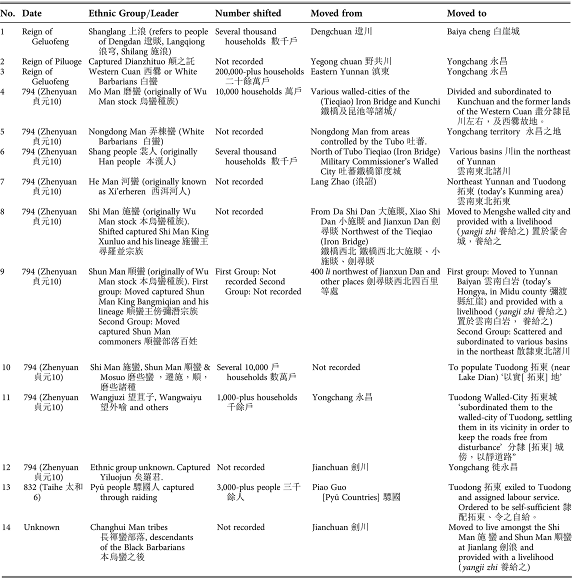
Expansion south went in tandem with shifting newly subjugated populations to strategic points within the kingdom. Three Nanzhao kings, Piluoge, Geluofeng and Yimouxun, vigorously expelled peoples, some of whom had been long established in what they considered to be their native lands. This brought stability to conquered areas because it reduced the risk of rebellion.Footnote 78 Nanzhao kings practised forced migration to augment demographic bases and to strengthen the military. The filling of Yongchang with peoples from other parts of the kingdom laid the foundations for Nanzhao's expansion into the Upper Ayeyarwady.
Of the fourteen recorded cases listed in Table 1, four involved forced migration from Lake Dian/eastern Yunnan to Yongchang, and one involved forced migration from the Lake Erhai area to the walled-city of Mengshe, the homeland of the royal lineage (Table 1 nos. 2, 3, 5, 8, and 12). The peopling of Yongchang began during the reign of Piluoge and peaked during Geluofeng's reign with the injection of over 200,000 Bai Man households. The number of Shi Man moved to Mengshe in 794 must have been small because Yimouxun settled them at the walled-city and provided them with a livelihood, probably indicating their status as hostages. The movement of over 200,000 households was the largest-scale forced migration recorded. The settlement of enormous numbers of Bai Man must have helped spread their culture and bond Yongchang with the Lake Erhai core area and augment Yongchang as a base for Geluofeng's advance into the Upper Ayeyarwady.
Populations shifted by Nanzhao, 8th to 9th century CE

Sources:
1.Yunnan Zhi, YSC, vol. 2, p. 23.
2. Ibid., p. 25.
3. Ibid., p. 32.
4. Ibid., p. 38. Yimouxun defeated the Tieqiao (Iron Bridge) in 794 (Zhenyuan 貞元10); see ibid., p. 55.
5. Ibid., p. 38. Original reads: ‘貞元十年,南詔異牟尋破吐蕃城邑,收獲弄棟城(蠻),遷於永昌之地。’
6. Ibid., p. 36.
7. Ibid., pp. 36–7.
8. Ibid., p. 37.
9. Ibid., p. 38.
10. Ibid., p. 51.
11. Ibid., p. 51.
12. Ibid., p. 24.
13. Ibid., p. 80.
14. Ibid., p. 36.
Around 794, Yimouxun also re-peopled the former lands of the Bai Man in the Lake Dian/eastern Yunnan area with 40,000 to 50,000 households from the Tieqiao (Iron Bridge) area ‘to fill the land’ (see Table 1 nos. 4 and 10).Footnote 79 This movement replenished the population around Tuodong walled-city (today's Kunming) constructed by Geluofeng's eldest son in 764, which had remained short of manpower since the deportation of over 200,000 households roughly thirty years earlier. Yimouxun also moved unrecorded numbers of He Man from the Lake Erhai area and Shang people from the Tieqiao area to Tuodong and northeast Yunnan in 794 (Table 1 nos. 6 and 7). In addition, the tenth monarch Fengyou 豐祐 settled over 3,000 Pyū at Tuodong to provide labour services in 832 (Table 1 no. 13). This manpower reinforced the Lake Dian area as the key administrative centre in eastern Yunnan. Nanzhao strategy was to de-populate new territories and re-people them with different ethnic groups from other subjugated lands.Footnote 80
Yongchang supplied troops to the Nanzhao military. In 794, Yimouxun moved over 1,000 households of Wangjuzi 望苴子, Wangwaiyu 望外喻 and others from Yongchang to Tuodong and settled them in the vicinity of the walled-city ‘to keep the roads free from disturbance’ (Table 1 no. 11). Nanzhao would not have transferred them to defend such a vital position if they were un-loyal. Their service ‘as the vanguard for the king and generals-in-chief’ on military campaigns bespeaks the trust the state placed in the Wangjuzi as military households.Footnote 81
The Wangjuzi encompassed the Puzi Man, whom Fang Guoyu identified as ancestors of the Wa.Footnote 82 Distributed from Pu Dan to Yue Dan on the west bank of the Salween, the Wangjuzi were renowned for their martial prowess:
Shengluopi pacified the Wangjuzi west of the Mekong River through punitive campaigns. Brave and fleet of foot, the Wangjuzi are skilled at using spears from horseback and ride their mounts without saddles. Going barefoot, they use little armour that only covers their chests and abdomens, leaving their thighs and knees exposed. They hang the tails of wild bovines from their helmets and charge forward swiftly as if they were flying.Footnote 83
Long association with the royal family from pre-unification days and their expertise as cavalry explains the recruitment of Wangjuzi for military service. They may have comprised one of the kingdom's four armies of crack troops (juzi 苴子).Footnote 84 Sources distinguish Wangjuzi from temporary warriors gathered locally by Nanzhao armies on the march. Nanzhao conscripted Puzi Man, Xunchuan, Heichi/Jinchi, Mang Man 茫蠻 and other conquered peoples from the southern and western border areas for military service in campaigns against Annan (a force of 100,000) in 863, Kunlun Guo (10,000–30,000), and Nuwang Guo 女王國 (over 20,000).Footnote 85
Forced migration to strategic points enhanced political centralisation because it augmented state-controlled manpower. Connected to Nanzhao through ties of allegiance, ethnic groups assigned to the military were deployed to walled-cities throughout the kingdom. Exposure to core area culture and the workings of the central bureaucracy promoted their political integration.
Governance of northern Mon-Khmer speakers
Finally, I turn to the establishment of governance over northern Mon-Khmer polities to illustrate Nanzhao's use of ethnic leaders to administer indirectly at the kingdom's periphery. I first argue that two ethnic groups, the Puzi Man and the Heichi/Jinchi and Mang Man, were both northern Mon-Khmer speakers, not Tai ethno-linguistic stock as hypothesised by Fang Guoyu, and then demonstrate that their degree of integration with Nanzhao institutions differed according to the time of conquest and distance from the royal centre.
Today the Wa, Ta'aang (Ch: De'ang 德昂; B: Palaung), and Plang (Ch: Bulang 布朗) are the predominant northern Mon-Khmer speakers inhabiting the area west of the Salween to the east of the Mekong.Footnote 86 The Pu Man, ancestors of these three groups, governed five polities west of the Mekong between the fourteenth and sixteenth centuries.Footnote 87 The largest polity, known in Sinitic script as Qingdian 慶甸, reputedly submitted neither to the Nanzhao nor to the Dali Kingdoms. It ‘acquiesced to soothing and instructions for the first time’ during the Taiding reign period (1324–1327) of the Mongol-YuanFootnote 88 and therefore remained outside the orbit of Sinitic control before the fourteenth century. Next, I discuss Mon-Khmer polities during the eighth and ninth centuries.
The Puzi Man were widely distributed over the jurisdictions of Kainan, Yinsheng, Yongchang and Xunchuan with tribes (buluo 部落) northwest of TieqiaoFootnote 89 along the upper reaches of the Mekong.Footnote 90 Fang Guoyu traces their ancestry back to the Pu or Pu Yue, one predominant ethnic group in the Ailao Kingdom.Footnote 91 The Pu/Puzi Man/Puman refers to a group of Mon-Khmer speakers distinct from the Heichi, Jinchi and Mang Man. The Puzi Man lived at higher latitudes (from 27° to 28°), and forged closer and more intricate associations with the Nanzhao state than the Heichi/Jinchi/Mang Man to their south. Though we have no details of their polities, Puzi Man referred to their tribal leaders as ‘superior chieftains’ (qiu wei shang 酋為上) in the ninth century, possibly indicating a continuum of small-scale Mon-Khmer polities from the Ailao Kingdom period.Footnote 92
Situated at the southernmost margins of Nanzhao's administration, the geographic distribution of the Heichi/Jinchi/Mang Man during the eighth/ninth century overlapped with that of the Jinchi/Baiyi in the thirteenth/fourteenth century. Fang Guoyu cited this concurrence as evidence for his hypothesis that the Heichi/Jinchi/Mang Man were all of Tai ethno-linguistic stock already organised into basin-style polities. Fang classified the Heichi/Jinchi in Yongchang and the Upper Ayeyarwady as Tai2 Nä1 (Tai Neua), which literally translate as ‘upper Tai’, and the Mang Man in the upper Mekong as Tai Lue (Tay2 Lü6).Footnote 93 This equivalence superimposes thirteenth/fourteenth century settlement patterns on eighth/ninth century data. It presupposes the arrival of the Tai in the Upper Mekong by the eighth century and assumes a historical continuum in their distribution from this time onwards. Below I examine the Mang Man designation to argue that these three groups were northern Mon-Khmer speakers.
Citing the Yunnan zhi, Fang Guoyu and Liam Kelley took ‘mang as the title for their ruler (jun 君)’Footnote 94 but construed it as a Sinitic variation of the Tai word mäng2(moeng).Footnote 95 The Yunnan zhi referred to Mang Man rulers as Mangzhao 茫詔, so Fang interpreted this designation as Tai lexicon mäng2 caw5 which would mean mäng2 with rulers.Footnote 96 However, no evidence exists to verify the arrival of Tai ethno-linguistic stock in the Upper Mekong as early as the eighth or ninth centuries.
A more plausible explanation is to understand mang as a prefix of Mon origin signifying kings or a kingdomFootnote 97 and zhao as the Sinitic transliteration of the Nanzhao term for principalities/kingdoms. In this reading, Mangzhao can be translated as ‘king of the realm’ and Mang Man as ‘barbarians with a king/kingdom’. This interpretation is further corroborated by Nanzhao's governance of the Mang Man through an administrative unit known as the Mangnai Dao 茫乃道 lit., ‘Circuit of kings and nobles’. Mangnai contains another Mon word naai, a title for male nobles of ruling families and community elites.Footnote 98 The Mangnai Circuit comprised ‘ten tribes of the Heichi [Black Teeth] and other stock’, all subordinate to the three walled-cities of Weiyuan, Fengyi and Lirun under the jurisdiction of Kainan. Heichi salt production probably attracted Nanzhao to the Upper Mekong.Footnote 99 Fang Guoyu positioned the Mangnai Circuit in today's Sipsong Panna area.Footnote 100 If Fang's identifications are correct, the Mangnai Circuit straddled the west and the east banks of the Mekong.
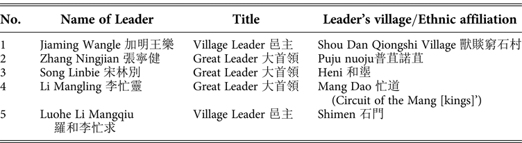
The circumstances behind the foundation of the Mangnai Circuit remain largely unknown. Yimouxun defeated the Mang Man in 794,Footnote 101 but the term Mangnai Circuit only appeared in 863. It probably dates back to the Mang Dao 忙道 or ‘Circuit of the Mang [kings]’ of the late seventh/early eighth century. The term Mang Dao is recorded in the Nanzhao Tuzhuan (The Pictorial Biography of Nanzhao), which recounts the tale of the Avalokitesva Bodhisattva converting ethnic leaders in Kainan to Acuoye Guanyin 阿嵯耶觀音 worship.Footnote 102 The scroll records the names of two mang leaders (see Table 2). The first is Li Mangling, the great leader of the Mang Dao, whom the Avalokitesva Bodhisattva encountered after reaching his territory (jie界) during the reign of the second Nanzhao monarch Meng Luosheng 蒙羅盛 (674?–712?).Footnote 103 The second was Li Mangqiu, a late-ninth-century Mang Man leader who notified the Nanzhao Emperor Longshun 隆舜 (r. 877–97) in a memorial of 897 that a bronze image of the Acuoye Guanyin cast by a wonder-working, proselytising Indian monk (a transformation of Avalokitesva) and a bronze drum beaten by Li Mangling roughly two hundred years earlier still remained on a mountain in his territory. The location of the Acuoye image and bronze drum reveals that Li Mangqiu's village, Shimen, was situated within the former territory of Li Mangling, indicating continuity of rule by mang leaders.Footnote 104 The retention of mang as a prefix in the personal names of Li Mangling and Li Mangqiu corroborates that kings or nobles of the Mang Man in the Upper Mekong had been governed loosely for over two hundred years at least.
Leaders of Kainan recorded in the Nanzhao Tuzhuan 南詔圖傳

Source: NZTZ, pp. 142–7.
The terms Mang Dao and Mangnai Circuit reveal the organisation of Heichi and Mang Man into small polities with leaders subordinate to Nanzhao's administration. Nanzhao governed Mon-Khmer populations indirectly through their leaders. Though the title ‘great leaders’ probably signifies larger scale political organisation than ‘village leaders’ (Table 2 no. 1. and no. 5.), these designations testify to Nanzhao's recognition of them as the rulers of their own regimes as well as vassals. Evidence in Table 2 reveals the widespread usage of Sinitic surnames by ethnic leaders at the periphery, including the Tibeto-Burman speaking Heni leader Song Linbie. Chinese dynasties granted Sinitic surnames to ethnic leaders in border areas on the assumption that the recipients accepted the Sinitic principal of surname exogamy and succession from father to son. The case of Mang Man and Heni leaders suggests similar practices by Nanzhao, and must have facilitated governance by positioning them within the Sinitic administrative framework as vassals at the margins.
The Heichi/Jinchi/Mang Man were ‘mixed stock’, indicating an assortment of people speaking different languages.Footnote 105 Ethnic heterogeneity hindered communication with Nanzhao officials because ‘their languages had to undergo three or four translations to be understood by the Hedan’.Footnote 106 Therefore, Yongchang and Kainan remained largely unintegrated with the Lake Erhai core area one hundred years after Geluofeng's conquest of c.762.
As already shown, the sources vitiate Fang Guoyu's claim for the Heizui/Heichi/Jinchi/Mang Man referring to Tai ethno-linguistic stock. The use of Mon titles for kings (mang) and aristocrats (naai) indicates the prevalence of pre-Tai styles of political organisation. If the Heichi in Mang Dao/Mangnai Dao referred to the same Heichi as those in Yongchang, then the distribution of their style of political organisation extended from the Salween to the Upper Mekong. Therefore, this broad west–east band, wherein variously-sized Tai polities mushroomed during the thirteenth century, must have been home to northern Mon-Khmer speakers during the eighth and ninth centuries.
This evidence verifies the differences in distribution of the two Mon-Khmer groups. The first group, the Puren/Puzi Man, were situated nearest to Nanzhao's epicentre at Lake Erhai and were incorporated earliest. Positioned south of the first group, the second group, comprising the Heizui/Heichi/Jinchi/Mang Man, extended west–east in a band from the Salween to the Upper Mekong. The Tai group known as the Baiyi were settled in the upper Red and Black River regions of north Vietnam in the mid-ninth century, and possibly in northern Laos and Isan in Thailand as early as the eighth century,Footnote 107 but there is no evidence for them residing in Yunnan during this period.
Conclusion
Evidence presented here supports the argument for Nanzhao as an early Sinitic state of Southeast Asia. The loose political structure of its centralised bureaucracy comprising multi-ethnic leaders who owed allegiance to the king, resembled those of other Southeast Asian classical kingdoms. By conquering and integrating pre-existing polities around Lake Erhai, Nanzhao successfully established a core area with sufficient manpower and grain to reinforce the king's supremacy. Its governance from walled-cities maintained the trade routes for India and Mainland Southeast Asia. Nanzhao resembled tenth-century Dai Viet in its limited acceptance of Confucianism, despite invoking Confucian civilisation ideology to morally justify governance of conquered peoples, and possibly having granted Sinitic surnames to strengthen ties of allegiance with peripheral ethnic leaders. But the political authority of Nanzhao kings differed from those of Dai Viet in extending beyond the core to regional areas through bureaucratic administration.
Nanzhao made its entry onto the stage of Southeast Asian history as a new actor in the drama of Sino-Tibetan power relations. It manipulated its alliance with Tibet from the mid-eighth century to expand administration south into the Upper Ayeyarwady and the Upper Mekong. By 794, when Nanzhao re-allied with the Tang, governance over these two regions had become permanent. Following in the footsteps of Nanzhao state power, He Dan migrants from the Lake Erhai core area traded and extracted natural resources from the Upper Ayeyarwady. Their economic activities must have contributed to the rise of Nanzhao as a powerful and influential kingdom during the eighth and ninth centuries. Its successor state, the Dali Kingdom, administered the same region until the mid-thirteenth century, but Ming policies resulted in the territorial legacy shrinking to roughly the size of today's Yunnan province.
Administration of Mon-Khmer and Tibeto-Burman speaking peoples was established in phases. The first phase involved Shengluopi's building of a walled-city at Yongchang and the subjugation of the Wangjuzi and Puzi Man c.712–728, which strengthened the royal family's power base before unification of the Lake Erhai core area in c.738. The second phase involved Geluofeng's subjugation of the Upper Ayeyarwady and the construction of a walled-city at Yinsheng c.762 to administer the ‘territory of the Heizui’, which paved the way for the third phase of closer administration through the Mangnai Circuit, probably after Yimouxun defeated the Mang Man sometime after 794. The three walled-cities of Yongchang, Zhenxi, and Kainan served as centres for governance in the Upper Ayeyarwady and Upper Mekong and as bases for launching military expeditions deeper into Southeast Asia. Gradual expansion southwest and southeast broadened Nanzhao's power base by augmenting manpower, securing natural resources, and strengthening control of trade routes. Yet administration did not generate ethnic transformation, though it marked the start of the long process of incorporating northern Mon-Khmer and Tibeto-Burmese speakers into successive Sinitic states and Chinese dynasties.
Nanzhao resembled Southeast Asian polities such as the Pyū by governing from walled-cities positioned at strategic points along communication routes. In the Upper Ayeyarwady and Upper Mekong, Nanzhao governed basins from walled-cities through local leaders loyal to the kingdom such as mang leaders in the Mangnai Circuit. The distribution of Nanzhao walled-cities marked the extent of governance and control over trade. The small number of walled-cities in the Upper Mekong reveals that Nanzhao may have placed less weight on communication with Dvāravati and Angkor than with the Upper Ayeyarwady. The intricate network of numerous walled-cities linking the Lake Erhai core area with the Upper Ayeyarwady serves as an indicator of the great importance of communication routes in this area. From walled-cities along the Upper Ayeyarwady, Nanzhao controlled trade routes to India and Pyū cities downstream and to Tibet upstream. Safeguarding these trade routes enabled it to regulate trade with other parts of Southeast Asia and Tang China. Relations with polities downstream and even further afield in the Mainland most likely involved a mandala style of lord–vassal relationship with raiding and punitive expeditions used for chastisement.
Abbreviations for Chinese sources