1. INTRODUCTION
Humans and machines are both essential parts of many complex systems in the maritime industry. Any changes to one will affect the other. The safe and efficient performance of joint systems is heavily dependent upon how functions are allocated between the human and the machine (Hollnagel, Reference Hollnagel2005). A key problem is that new technological equipment is sometimes bolted on to an existing system with little prior investigation of its potential impact on the functioning of the joint human-machine collaboration. This paper examines the introduction of the Automatic Identification System (AIS) to the ship's bridge and its potential impact the on safety of marine navigation. New technology and automation are introduced on board ships for many different reasons, including economics, to enhance safety, to fulfil commitments under new regulation, etc.
2. AUTOMATIC IDENTIFICATION SYSTEM (AIS)
The International Maritime Organisation (IMO) (2001) objectives for implementation of AIS are to enhance safety and efficiency of navigation, safety of life at sea, and maritime environmental protection through better identification of vessels, assisted target tracking, and improved situational awareness and assessment through simplified and additional information. AIS can also improve the quality of vessel traffic surveillance (VTS) and waterway management. The motivation for the adoption of AIS was its autonomous ability to identify other AIS fitted vessels and to provide additional precise information about target ships that could be used for collision avoidance. It has the ability, due to its operation on VHF radio frequency, to detect other equipped targets in situations where the radar detection is limited such as around bends, behind hills, and in conditions of restricted visibility by fog, rain, etc. It exchanges data regarding navigational and voyage related information of ships and other related messages with other ships and shore stations. It can handle multiple reports at different update rates, which vary according to speed and status of the ships. The information can be received by anyone equipped with a relatively low cost receiver. The AIS information consists of different types of data classified as static, dynamic, voyage related information, and short safety messages. Static data are entered into the AIS on installation and need to be changed only if the ship type changes by a major conversion or if her name or call sign changes. Most dynamic data will automatically be updated through the AIS-connected ship sensors, and voyage related data is entered manually during each voyage. The following information is included in the AIS messages (IALA, 2002):
• Static information:
— IMO and Maritime Mobile Service Identity (MMSI) number
— Call sign and name
— Type of vessel (passenger, tanker, etc.)
— Length and beam
— Location of position fixing antenna such as GPS/DGPS (aft of bow, port or starboard of C/L)
• Dynamic information
— Ship's position with accuracy indication (for better or worse than 10 m) and integrity status
— Time in UTC (coordinated universal time)
— Course over ground (COG)
— Speed over ground (SOG)
— Heading
— Navigational status (e.g., not under command, constrained by draught, etc.)
— Rate of turn (where available)
— Angle of heel (optional)
— Pitch and roll (optional)
• Voyage related information
— Ship's draught
— Type of cargo
— Destination and estimated time of arrival (at master discretion)
— Route Plan-waypoints (optional)
— Number of persons on board (on request)
• Short safety messaging
— Short text messages with important navigational safety related information are shown in an extra window.
Fast mandatory implementation of AIS equipment for SOLAS ships, without adequate earlier research on its use, may be having a negative impact on its success and hence endanger safety of marine navigation. The collision between Hyundai Dominion and Sky Hope (Marine Accident Investigation Branch (MAIB), 2005a) is an example of AIS-assisted collision in which the OOW aboard Hyundai Dominion used the AIS text facility to communicate with the Sky Hope. Poor performance and transmission of erroneous information by AIS are important issues that can affect its usefulness and have been raised in the 16th session of IALA AIS Committee (Sandford, Reference Sandford2005). Research at Liverpool John Moores University has been carried out to investigate human error issues in AIS data accuracy and their impact on the ships bridge.
3. AIS DATA RESEARCH STUDIES
This section describes three separate studies of AIS data, each assessing different AIS fields. Section 4 then discusses the results of the studies. However, even with three studies, not all AIS fields have been evaluated.
3.1. VTS-based AIS study
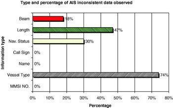
This study was conducted over about one month, during September–October 2005 at Liverpool Vessel Traffic Service (VTS) station. The study was conducted on vessels leaving and approaching Liverpool Bay, and on vessels at anchor or alongside in port. The data collection was carried out for about 6 hours a day (3 hours morning and 3 hours afternoon), at the time of high tides when ship movements were increased on the Mersey. Two sets of ship's data were compared, information from AIS and the same items of information from the database available in the port VTS station. The information collected consisted of MMSI number, vessel type, ship's name and call sign, length, and beam. The port information is updated from the database of Lloyds Register. Additionally, the AIS ships navigational status was checked against its radar plot. During this period, a total number of 94 different AIS equipped vessels (V/L) were investigated. In some cases, the ship itself was contacted by VHF, but this was not routinely done because of the possibility of interfering with safe navigation in a pilotage area. Many discrepancies found were in the fields of vessel's status, beam, length and type; the percentages are summarised in Figure 1. In many cases the inconsistencies may be considered minor, as will be shown in the discussion later.
Percentage of ships observed with inconsistent AIS information in the VTS-based study.

3.2. Data-mining AIS study
This is a study conducted earlier (first reported in Harati-Mokhtari et al. Reference Harati-Mokhtari, Brooks, Wall and Wang2005) for data recorded by AISLive Company of Lloyds Register-Fairplay Ltd. The data consisted of 400,059 AIS reports from 1st March to 17th March 2005, collected from a number of AIS receivers located in a worldwide geographical area. The initial data was collected by AISLive for a limited number of detectable errors of MMSI number, IMO number, position, course over ground (COG), and speed over ground (SOG). The initial data examination showed that 30,946 reports were associated with at least one error of above-mentioned types. The error rate of about 8% detected means that 1 in every 14 AIS transmissions in the sample was associated with at least one piece of erroneous data of the above-mentioned types. In addition, these 30,946 AIS transmissions were analysed at Liverpool John Moores University for additional detectable problems such as errors in name, call sign, ship type, ship dimensions, etc.
3.3. Proactive AIS study
Data was also collected through the services of AISweb of Dolphin Maritime Software Ltd, UK. The main focus of this study was to look specifically for duplicate MMSI numbers and behaviours of some AIS stations with incorrect MMSI number in a wide geographical area mainly in European waterways from 23rd November 2005 to 2nd May 2006. Four incorrect MMSI numbers of 0, 1, 1193046, and 999999999 were kept under surveillance. The data for these AIS stations were recorded at ad-hoc times and dates; there was not continuous monitoring of the network.
4. FINDINGS
The findings of the research are summarised below, organised by individual AIS field.
4.1. MMSI number
Maritime Mobile Service Identity (MMSI) number is a unique number given to every vessel for AIS identification. It is a data field that should be manually entered at the time of installation of AIS on the bridge. It is the sole means of discrimination between different AIS transmitting stations within the AIS system. A particular problem that could have negative impact on the safe use of AIS is when the MMSI number has not been correctly entered. Broadcasting of the same MMSI number by more than one station creates discrepancies such as target swap in information received by other AIS stations. This problem was particularly noted with many vessels transmitting the incorrect default MMSI of 1193046 (The Nautical Institute, 2005a). This may be the default MMSI for a specific model of AIS transponder and due to not entering the MMSI number in accordance with installation procedure or a specific equipment fault, which means that it defaults back to this number. Whatever the cause, more than one ship concurrently has been using this MMSI number.
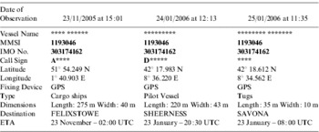
In our Proactive AIS study observations were made on an ad-hoc basis from 23rd November 2005 to 2nd May 2006. There were up to 25 vessels transmitting the incorrect MMSI number of 1193046 using the AISweb database. On all these occasions, the MMSI number was associated with a different ship with different particulars. The only common particulars between these observed stations were MMSI and IMO numbers. In some cases even the IMO numbers were also changed into a different figure. Table 1 illustrates three particular examples. Three more MMSI numbers (0, 1, 999999999) appearing on multiple stations were also detected in the Proactive AIS study, as shown in Table 2. Navigating officers could prevent such faults by checking their AIS transmission data regularly to be sure of transmitting the correct information.
The same MMSI number with 3 different ships' particulars transmitted on AIS (names & call signs have been blanked out by the authors).

MMSI numbers detected on multiple AIS stations.

In another probable observation of this problem, The Nautical Institute (2005b) reported that the MMSI numbers of a vessel at anchor and a passing ferry swapped over and remained thus so for a certain period of time until the passing vessel was some distance away from anchored vessel. In another Nautical Institute (2005c) report an AIS target swap showed as a sudden and unexpected change of data from a container vessel into a vessel engaged in fishing. The heading changed from Genoa into Casablanca with a 28·5 m draught. She showed this false information for about 15 minutes, until the data reverted to indicate the correct status. In another instance, a harbour service vessel operating in a UK port changed its transmission to a vessel of 220 m length, heading for Casablanca and this continued for four days until the vessel was informed about the error. While we do not know the exact reasons for errors of this type, they are most likely due to faults in programming, installation, or equipment design. Further research and monitoring of the equipment (possibly from shore) is required to check for errors of this type.
In the “Data-mining AIS study”, 2% of the erroneous static information identified was in the field containing MMSI numbers. The errors identified only those incorrect MMSI entries with figures incorporating less than 9 digits. It is possible that, even with the correct field length, some of the digits showing are wrong when compared with an accurate MMSI database. The errors of this type could be due to omissions or mistakes by technicians responsible for installing the equipment on board ships. In a small number of cases it could be test equipment.
4.2. Vessel type
This information is nominally part of the static data which infers that it is input to the AIS by the equipment installers. Vessel type must be selected from a default list predefined in the factory by the particular AIS equipment manufacturers. In the VTS-based AIS study, out of 94 ships under investigation, 6% of vessels had no vessel type available and 3% were defined as “vessel”. Altogether, the researchers and VTS operators were unhappy with 74% of the observed ship types and in the Data-mining AIS study the equivalent figure was 56%. Vague or misleading vessel types are significant problems in this kind of information. For example, entry of a general ship type such as cargo or vessel rather than a more informative available ship type.
Table 3 shows examples from our VTS-based AIS study where similar vessels were broadcasting different ship types under AIS. In some cases the problem is unnecessary vagueness, as for example the use of cargo for a vessel, when tanker could have been correctly used. In other cases, the most important and appropriate descriptor may be difficult to assess, unless more guidance is provided to navigators and installers. For example, a high-speed ro-ro passenger ferry can legitimately be defined as a High Speed Craft or Passenger or Cargo under AIS. All three types were observed in this research separately on three sister vessels servicing the same port.
Examples of similar ships showing different AIS ship type descriptors from the VTS-based AIS study.

An insufficient number of defined categories for ship types and the unfeasibility of including every potential ship type is one reason for the problems in this category. Some very common and distinctive vessels are not separately identified in the AIS specification. For instance, container vessel, car carrier, and bulk carrier would all be identified as cargo. Similarly, tanker applies to the different categories of chemical tanker, petroleum tankers and gas carriers. Such differentiation would be helpful for visual identification at sea, as well as for VTS operators. However, incorporating more ship types would require time-consuming regulation and system changes and is not feasible in the short-term. Within the current system, it would increase confidence in the system if navigators see more accurate descriptions with fewer variations between similar vessels. One of the first steps toward increasing navigators' confidence levels would be to provide more explicit guidance to installers and navigators.
A more minor problem is that the AIS text descriptors of ship type number codes available for selection vary slightly from one manufacturer to another. The actual list of options for ship type available is limited and is transmitted as a 2-digit number in the AIS message. Standardisation, across all AIS manufacturers, of the text descriptors would be a good feature of the equipment which would help navigators moving between different ships to become familiar and accustomed to the information displayed. For example on one model the ship type number 32 is Vessel-Tow>200 m, Breadth>25 m while on another model the same number is displayed as Towing (large tow). Additionally, this so-called static field showing vessel type is altered for some vessel types according to their navigational status on voyage. There is also potential ambiguity between a vessel type and vessel status as in the ship type Vessel-sailing used in some models. These aspects are discussed in detail later in section 4.4.
4.3. Ship's name and call sign
Although in the limited VTS-based AIS study there were not any incorrect name or call signs identified, in the wider Data-mining AIS study, problems noticed were that fields were left blank. No names or call signs were given in 6% of the filtered static information sample. This represents 0·5% of the total unfiltered AIS messages recorded. Another problem noticed during this study is that abbreviations were used in the field of ship name. In many cases, but not all, this was because an insufficient number of characters was available since the AIS equipment limits this field to 20 characters. The errors in these two categories are either due to omission by the installing technicians or due to the regulatory design, which does not allow ships names in full if they are longer than 20 characters. These limitations mean that there can be confusion about the ship's name, when a prime purpose of AIS was to eradicate this problem. It is still a common practise to use a ship's name in voice communications even though the alternatives of using MMSI number (via Digital Selective Calling) or call sign are also available. Alternative suggestions would be for the IMO to pass a regulation limiting ships names to 20 characters or to increase the minimum number of characters available for ships names in AIS equipment, or to train navigators to completely avoid using the ship name for communications.
4.4. Vessel navigational status
Ship status is dynamic information that has to be manually entered by the officer of the watch (OOW) and changed or updated as necessary by the navigation officer during a passage. In current AIS receivers, the equipment does not incorporate automatic crosschecking of information received and transmitted. In the VTS-based AIS study 30% of ships were detected as displaying incorrect status information and there were probably more examples undetected by the research. Four percent were displaying an incorrect status for power driven vessels underway using their engines by showing their status as underway sailing, an option that should be used only by sailing vessels under sail. Other examples detected by the research include a ship underway at 10 knots shown as moored and ships alongside or at anchor shown as underway or sailing.
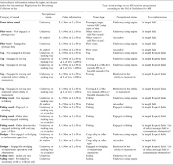
Navigators, with enough information about target navigational status, can decide when a ship would be the “stand-on” or “give way” vessel. Navigational status is useful for situational awareness and in collision prevention. Rather confusingly, the AIS data programming shows that navigational status for some vessel categories is given in the field of ship type as well the navigational status field. For example, the navigational status of tugs or dredgers is shown in the field of ship type and not just in the field of navigational status as shown in Table 4 where there are some examples of ship types, their different status according to IRPCS and the corresponding data, which would be shown by the AIS. The selected examples show how the philosophy of AIS data is different between different vessel types. In some categories the system has kept ship type according to stated philosophy of the static AIS data so, for example, a fishing vessel remains a fishing vessel throughout its voyage and life. Similarly, in Table 4, a sailing vessel would change only navigational status and not ship type. The voyage related field of navigational status would vary on voyage depending on whether it is engaged in fishing or not. Conversely, a tug would be shown as the static field of vessel type of tug when not involved with towing. When the tug picks up a tow, the so called static field of vessel type is changed from tug to towing or towing and length of tow exceeds 200 m or breadth exceeds 25 m as applicable (that is the word tug actually means a tug not towing). The reason for this peculiar decision by AIS regulators is undoubtedly because the navigational status field can then be used by a tug to show when it is additionally restricted in her ability to manoeuvre or not. Similarly a dredger would alter its ship type throughout its voyage. The logic behind this use of AIS fields will not be apparent to most AIS users unless it is pointed out during their training. It is also not clear if a pilot vessel should or should not change its vessel type when it is not engaged in pilotage duties.
Comparison of selected ship types and navigational statuses defined in IRPCS with AIS options according to IALA (2002) guidelines.

This aspect of AIS data on “anti-collision” status is compounded by at least one manufacturer, which provides a user manual that does not tell the navigator how to change any of the static data. This includes the vessel type field, which we have shown in some vessel types need to be changed on a voyage basis and not just by the installer. It is important for the navigators to be aware and prepared for such ambiguities by specific AIS training both from the programming and from the interpretation perspectives, as indeed they are currently made aware of the intricacies of lights and shapes. In principal, modifications could be made to the number of AIS fields to improve the communications and the information provided, but this is not an option at this stage of implementation. However, the AIS fields do convey the required information but, to be really effective, it is necessary for navigators to receive adequate training in programming and interpretation.
4.5. Length and beam
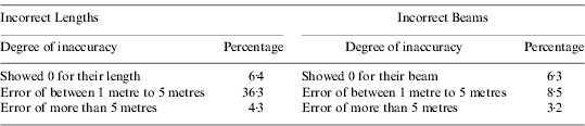
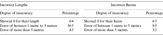
Forty seven percent of the ships in the VTS-based AIS study displayed incorrect length and 18% of them displayed incorrect beam in their AIS information when compared with the VTS database or with the information reported on VHF. The vessels reporting incorrect lengths and beams are given in Table 5. Some of these ships were contacted on the VHF to confirm their correct dimensions and the results confirmed that data shown by the AIS was not correct. In the Data-mining AIS study, apart from non-availability of the length and beam, the errors identified were limited to an incorrect correlation between length and beam, such as beam being greater than length. Length and beam are static information on AIS that should be input to the equipment at the time of installation. This information would only need to be changed if structural modifications were to be made to the ship. This is an error of wrong data input by those who installed the AIS equipment on board the ships. (Note that another 67% of observed vessels indicated an error of less than 1 metre in beam, which has not been included in our inaccuracy figures for the beam. Although, no doubt, some discrepancies are due to rounding, the majority of cases had an inaccurate non-zero decimal figure (e.g. 23·7 instead of 23·3)).
The vessels reporting incorrect lengths and beams over the AIS, observed during VTS-based AIS study.
4.6. Position
Full evaluation of the AIS positional information was not practical in the present studies. However in the Data-mining AIS study it was found that 1% had shown latitude of more than 90° and longitude of more than 180° or the position 0°N/S, 0°E/W. This could be because the position fixing system is not working or was improperly connected to the AIS equipment. Proper comparison of the position data from AIS with data from other means of positioning could be investigated in future to assess its practical accuracy.
In MARS report 200552 (The Nautical Institute, 2005c) which highlighted the discrepancies of AIS, such as the vessels transmitting AIS position 00°N 000°W, it was strongly recommended that AIS should only be used as a situational awareness tool and not for collision avoidance.
4.7. Draught
An obvious discrepancy in 17% of AIS draught entries observed in the Data-mining AIS study is the non-availability, or the reporting of 0 m draught. It was also observed that in 14% of the AIS entries draught is greater than length of the ship. Since the ship's draught is voyage related information it must be entered by OOW and must be updated before and possibly during the ship's voyage. Any inaccuracy in this field of AIS information could be OOW omission to enter or update the draught or his/her error of commission by entering incorrect figures. Further research is required to quantify the errors in draught and the frequency of update by the navigator, as the present study has not explored the full extent of errors in this field.
4.8. Destination and estimated time of arrival (ETA)
The destination and ETA were not investigated during the VTS-based AIS study but were investigated within the limitations of the Data-mining AIS study. In the sample of 30946 AIS transmissions, 49% showed obvious errors in the fields of destination and ETA. Some of the vague or incorrect AIS entries for destination found were; a number instead of destination, a country name instead of port name, an abbreviated name difficult to interpret, the words not available or not defined or null, mischievous input clearly violating the rules and regulations (e.g. to hell) or a blank field. It should be appreciated that the study was only able to identify inconsistencies and possibly left many incorrect entries undetected. Conversely the vague entries for ETA and destination may actually be the vessel's best knowledge in a small number of cases. Navigators can find accurate knowledge of the correct destination of other vessels in areas of high traffic congestion and in port approaches or at the entrance to inland waterways very useful. Destination identification can improve navigation safety through enhanced planning for manoeuvring with early prediction of other traffic's manoeuvring such as alterations of course and/or speed. It was observed that ETA was not updated in a number of AIS transmissions. Inaccuracies noticed in the ETA field were dates in the past or an ETA in the very distant future. Although this field is optional, ships should maintain it accurately and regularly if it is to be of any use.
4.9. Heading, course over ground (COG) & speed over ground (SOG)
Unfortunately during this research it was not possible to investigate heading, COG, and SOG. Further research on the accuracy of such fundamental AIS information will ascertain the importance of AIS in anti-collision activities and successful data fusion with radar information. Some problems have been reported in this regard. According to one report (The Nautical Institute, 2006), a heading offset of 90 degrees or more was noticed in a vessel in a traffic separation scheme on a passage to Longview, Washington. The AIS inaccuracy in this case could be the result of a compass input problem or with the calibration, testing, and maintenance of the AIS equipment not conforming to related directions and regulations.
4.10. Other AIS-related problems
If AIS is to be useful in enhancing navigational decision making on the bridge, the focus and main areas of concentration should be diverted toward its correct installation, its integration with other navigational equipments, the accuracy of manual data being input to the system, the presentation of information and the ability of the mariners to correctly interpret the information received. Bailey (Reference Bailey2005) claims that 80% of AIS messages contain some error or inaccuracies. Installation of AIS and mariners' training in the use of equipment should ideally have been prioritised in pre-implementation or implementation phases as they have become important issues affecting AIS operation. AIS has the potential to be a useful navigational aid if correctly used, due to its high updating rates on the changes made by other ships (The Nautical Institute, 2005c). However at present the reality is that in many cases, information which is being provided is directly misleading. This is especially dangerous if the AIS information must be relied upon at critical times such as when visibility is restricted and when radar detection ability is limited.
Additionally, insufficient use of AIS is another problem identified in the literature, and illustrated in the case of the collision between Amenity and Tor Dania (MAIB, 2005b). The investigation concluded that, if the master of Amenity had referred to the existing AIS information, he would have been able to identify heading, direction and rate of turn of the other ship. This information, which has a 2 second update rate, could have corrected the wrong visual impression about the aspect of Tor Dania.
It is not clear whether text messages should be used for such safety-related purposes by the mariners. If they are to be used, both auditory and visual warning signals, with adjustable individual response parameters, could be incorporated to facilitate better and more appropriate responses (Hellier and Edworthy, Reference Hellier and Edworthy1999). The warning signal could be in the form of a buzzer associated with a text message that could appear on the screen to inform the mariners about any incompatibility of the navigational status with speed. The accident between Hyundai Dominion and Sky Hope (Marine Accident Investigation Board (MAIB), 2005a) where the safety text message was sent to warn about a collision risk but was not identified by the addressed vessel is an example of uncertainty on the use of text safety messages.
The investigation of the collision between Cepheus J and Ileksa (MAIB, 2005c) also found poor use of the AIS when the OOW on Cepheus J failed to notice the presence of Ileksa ahead of him. Improving negative aspects of AIS can increase its reliability and its users' trust level. If the regulatory authorities are insisting that AIS is employed as an anti-collision aid then it is essential for correct information to be transmitted.
Contrary to intention, there is some evidence that AIS technology actually increases VHF calls between ships for the purpose of collision avoidance. Bailey (Reference Bailey2005) claims that about 90% of 245 cases of VHF calls recorded at Dover Coastguard Channel Navigation Information Service (CNIS) were concerned with collision avoidance. Precise identity (i.e. name, call sign, etc.) of target ships available via AIS will perhaps stimulate further use of VHF on board the ship. Consequently, this may cause more violations of the anti-collision regulations and reduce the ability of the OOW to take appropriate actions in ample time as required by anti-collision regulation. Thus, AIS could be a factor augmenting the risk of collision in some instances. Increased VHF calls can cause distraction and take the attention of navigators away from engaging in more urgent actions needed to avoid collision. In addition, they can cause confusion between two ships if they do not agree on specific actions required (Swift, Reference Swift2004). The increased potential for local arrangements between ships over VHF may cause more confusion and breach of rules of the road (ROR) (Farmer, Reference Farmer2004). In The Nautical Institute (2005a) there is an example of a request for an agreement in opposition to rule 15 of the International Regulations for Preventing Collisions at Sea (IRPCS) where a naval ship (give way vessel) navigating in international waters asked another approaching ship (stand on vessel) to alter her course 20 degrees to starboard. The IRPCS does not mention that VHF should be used for anti-collision purposes but it has been a routine practice by some navigators. This matter needs urgent clarification by the regulatory authorities.
5. ANALYSIS
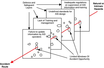
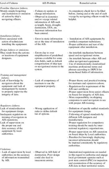
Using a system approach, based on an application of the “Swiss Cheese” model, shown in Figure 2 (Reason, Reference Reason1990, Reference Reason1997), latent failures at different levels of the AIS system are summarised. Table 6 shows summaries of actual failures observed in AIS usage with suggestions made for remedial action that could be taken to eliminate or reduce their likelihood and thus minimise accident opportunities. This study indicates that for the AIS to be successful in its proposed aims and objectives, further steps need to be taken by various stakeholders, including the regulatory organisations.
The “Swiss Cheese” model of human error in AIS system, contributing to accident (adapted from the generic model of Reason, Reference Reason1990, Reference Reason1997).

Summaries of the human failures associated with AIS equipment.

6. CONCLUSIONS
The findings of the present studies and previous research show that the data provided by AIS are not reliable in many cases and therefore mariners cannot wholly trust the equipment. This could further jeopardise AIS usage and data quality.
The list of options available should be standardised according to different types and navigational statuses of the ship (as defined in the International Regulation for Preventing Collisions at Sea) such as in the IALA (2002) guidelines on AIS. This will overcome the current differences in number and phraseology of options available in AIS equipment made by different manufacturers.
Some navigators and accident investigators have suggested that the AIS assists safe navigation by providing additional information for anti-collision purposes. The use of AIS fields to show anti-collision status has some peculiarities for some vessel categories not dissimilar to some of those in the use of lights and shapes. Understanding the use of lights and shapes is a familiar part of navigator training and similar AIS training needs to be introduced. This training would also encourage the use of the narrow definition of the word sailing and other similar phrases in the context of the AIS message and in the IRPCS.
It is not clear whether the safety text messaging available in AIS equipment could or should be used for anti-collision conversations between vessels. Regulations about this subject need to be properly clarified by IMO. Should this method of collision avoidance be approved, the existence of an effective audio-visual warning signal to notify the receipt of safety text messages would also help. Further training for navigators is also needed on these matters.
This research has highlighted that many of the input errors in the field of ship's navigational status are due to memory slips or omission to execute a required action. The AIS equipment could easily have self-checking mechanisms and links to other equipment to detect obvious inconsistencies. For example, an interlink mechanism between speed and navigational status would be helpful. In cases where the speed of the ship, which is automatically being input to the system from GPS or from a speed log, exceeds a certain level a warning signal could prevent the navigational status from showing conditions such as moored or at anchor. The existence of a warning signal would alert navigators of erroneous conditions in early stages of development. Use of warning signals could also be extended to include a link with the ship's navigational light system in such a way that a signal could warn the navigator in case of any conflict between the actual navigational status of the ship and the status shown in AIS data. Indeed, the logical step is to have one button for both tasks.
The automation of AIS is mainly related to the transmission and reception of data and the integrity of the system is dependent on many manual inputs. The current unreliability of AIS data is a critical issue mitigating against the use of AIS as a trustworthy navigational aid in collision prevention activities. Proper supervision, surveillance of accuracy, and enforcement of quality of AIS data by competent maritime authorities would enhance its efficacy in all navigation operations.
Proper training of navigators and operators ashore on the use of AIS, its capabilities and limitations is an important issue as demonstrated in the Hyundai Dominion and Sky Hope (Marine Accident Investigation Branch (MAIB), 2005a). Lack of familiarity of navigators with AIS equipment is likely to reduce the confidence of navigators in using it in their normal anti-collision activities. An international mandatory training course including theory and practice of AIS equipment would improve its use at sea.
Apparently, in most cases, some optional information fields of the AIS such as destination and ETA are not updated. This may be because they are not being regarded as important information for navigation. Navigators need more encouragement to maintain the data showing on their equipment. It will also give them more confidence in AIS data broadcast from other ships.
This study has concentrated on the main AIS fields that are manually inputted and has not specifically considered information relayed automatically from shipboard sensors, such as speed, position, heading, etc. Further research is required to examine any human error issues in the setting up and the interpretation of shipboard sensor information by navigators.
ACKNOWLEDGEMENT
The authors are grateful for the assistance of the following organisations without which this study would not be possible.
AIS Live Company Ltd. of Lloyd's Register-Fairplay – UK. http://www.aislive.com
AISWEB, Dolphin Maritime Software Ltd. – UK. http://www.dolphinmaritime.com
Mersey Docks and Harbour Company, VTS – UK. http://merseydocks.co.uk
Chabahar Maritime University (CMU) – Iran for financial support for the principal researcher. http://www.cmu.ac.ir