SOUTH TYNESIDE
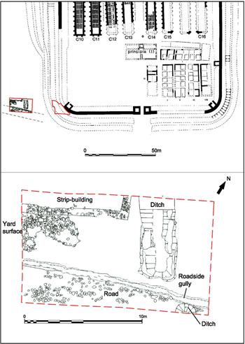
(1) South Shields fort (Arbeia) (NZ 365 679): excavation was completed in the area excavated since 2009,Footnote 34 20 m south-west of the southern angle of the extended supply-base fort (fig. 6).
South Shields. Excavation areas and road in use outside fort throughout Roman period. Latest phase vicus building shown. (© Tyne & Wear Archives & Museums)

The sequence now established can be recapped as follows. Overlying pre-Roman Iron Age ard marks, themselves sealed by an abandonment layer of windblown sand, the earliest Roman activity encountered consisted of a series of dumps containing abundant pottery and finds, apparently tipped onto the ground from the north-west. The pottery was of Hadrianic and early Antonine date (c. a.d. 120–160) and presumably emanated from an as yet undiscovered early fort at South Shields or its vicus. The upper horizon of the series of tip lines contained much burnt daub.
All these deposits were sealed by an extensive dump of clean clay over 1 m deep. Over this was laid a WSW–ENE-running road with a curving stone-lined channel on its north side. The road had a steep downward gradient to the WSW, suggesting that the clay dump may have been the eastern edge of material filling up a hollow or valley to the west that the road had to cross. The pottery from the clay dump and the underlying rubbish dumping suggests that dump, road and channel were constructed at the same time as the first stone fort of c. a.d. 160.
At some point before the early third century the drain was robbed, backfilled and sealed by a further clay dump and a resurfacing of the road, which might have represented a further attempt to level up the depression to the west.
The upper clay dump was cut by the outermost of the ditches of the extended supply-base fort constructed c. a.d. 205–8. The road was reconstituted with paving at a higher level, its surface continuous with a paved walkway which led north into a hollow used for gold- and silver-smithing, dated by coins and pottery to the third century and representing vicus activity immediately beyond the fort defences. The metal-working hollows went out of use by the later third century.
After this the road was resurfaced and the backfill of the hollows themselves was overlain by a new stone building of which one corner was recovered within the trench, perhaps the rear corner of a strip-building fronting onto a road roughly coincident with modern Baring Street. This suggests that, in contrast to the outlying part of the South Shields vicus excavated in 2002, abandoned by c. a.d. 270,Footnote 35 there was a final phase in this part of the vicus closer to the fort which must have been of the later third or perhaps even the earlier fourth century. The stone building was eventually destroyed by fire and contained a thick layer of burnt daub.
A ditch of small size was dug at some stage, 2.5 m beyond the former outermost ditch, now filled up. This new outermost ditch cut the backfill of the third-century metal-working features. The ditch terminated immediately north of the road, which was presumably still in use. The road surface was finally cut by a rounded intrusion projecting from the south-eastern edge of the excavation, which must mark the final disuse of the road. The intrusion was possibly the terminal of a ditch; if so, and if contemporary with the ditch described above, a gap of 2 m was left between terminals, but not coinciding with the course of the former road. The Roman sequence was followed by a deep deposition of ploughsoils.
In a second area, to the north-east, measuring 10 by 10 m and immediately abutting the southern angle of the visible fort, tumble from the collapsed fort wall, masking some elements of articulated collapse, lay over the fill of a ditch 9 m wide and 2.3 m deep, beyond a berm 2 m wide. This ditch was identical to ditch H excavated at the south-west gate in 1985.Footnote 36 At the south-west gate this ditch was found to cut an earlier ditch fill containing the latest types of Roman pottery and Theodosian coins, and so it is presumably a recut of fifth-century date.Footnote 37
NORTHUMBERLAND
(1) Vindolanda (NY 769 663): excavations continued in the two areas of the site explored in 2015:Footnote 38 (a) the south-eastern quadrant of the last stone fort; (b) below the remains of the third-century extramural settlement into the centre of the pre-Hadrianic timber forts and into a 25 m-long section of the southern defensive ditch of the early third-century Severan fortlet.
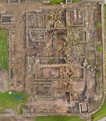
(a) The intervallum roadway on the southern perimeter of the fort and its associated southern rampart mound, c. a.d. 213+, were removed to explore a new series of circular huts which are associated with the Severan occupation of the site, c. a.d. 208–11 (fig. 7). The circular huts, constructed in two rows of five, back-to-back, with roads between them, had been built with two or three stone foundation courses of large soft yellow sandstone masonry. It is likely that the building materials used had been recycled from the demolished remains of the Antonine fort as most of that building phase uses the same distinctive masonry rather than the harder buff grey sandstone used in other periods (including the associated Severan fortlet). The interior of the roundhouses showed a degree of nonconformity and had been furnished with a combination of earthen, flagged and tile floors and room divides; they had an internal diameter of approximately 3.5 m between the outer walls. The greater degree of individuality in the construction of these roundhouses was similar to buildings found in 2016.Footnote 39 Further work in the south-eastern quadrant exposed the remains of a fine Antonine date toilet block on the corner of the fort, built in stone into the turf and clay rampart mound. The remains of Antonine period workshops with associated kilns, crucibles, drains and walls were located to the north of this toilet block below the remains of the 2015 roundhouses and later third- and fourth-century barracks.
Vindolanda. A composite image of the south-eastern quadrant of the last stone fort. (Created by Adam Stanford. © The Vindolanda Trust)

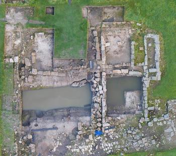
(b) Continuing from 2015, more of the pre-Hadrianic buildings which made up the central range of Vindolanda forts II–V (c. a.d. 92–140) were explored beneath the foundations of the third-century extramural settlement. As well as recording the timber structures/sequences in the area, several important artefacts were recovered which included a branded barrel stave, ink and stylus-tablets (11) and many wooden and leather artefacts. The southern part of the area incorporated the line of the rampart mound and ditch system of the Severan fortlet, which was contemporary with the roundhouses explored in area (a). A 25 m section of ditch was excavated; this impressive V-shaped feature was 6.5 m across and 2.7 m deep (fig. 8). The ditch had several depositional phases during its short life with a final abandonment phase which included 421 Roman shoes. Of the 421 shoes, approximately half may have been used by children or young adults, or due to their shape may have belonged to women rather than men. Only a single pair of shoes was recovered, and these had belonged to a small child.Footnote 40
Vindolanda. An aerial photograph of the extramural excavations and the Severan fort ditch showing the third-century extramural foundations situated over the water-filled southern Severan fort ditch. (© The Vindolanda Trust)