


1 Introduction
The Japanese Antarctic Research Expedition (JARE) used a 35 MHz Scott Polar Research Institute MK-II radio echo-sounder during glaciological oversnow traverses in Mizuho Plateau from 1969 to 1974 (JARE- 10 to JARE-14) (Reference Shimizu, Naruse, Omoto and YoshimuraShimizu and others 1972, Reference Naruse and YokoyamaNaruse and Yokoyama 1975, Reference OmotoOmoto 1976). However, the records were discontinuous and their interpretation by these previous investigators was not always correct as was pointed out by Reference Wada and MaeMae (1978). The glaciological party of JARE-10 installed a trilateration network which was tied to Motoi Nunatak in the Yamato Mountains in December 1969. They collected nine meteorite pieces on the bare ice in the vicinity of Motoi Nunatak. This discovery led to a further search for meteorites and about 4 000 have been collected so far. The glaciological party also surveyed the western part of the Yamato Mountains, departing from the northern part of the mountains along 71°S. The trilateration network and other offset markers were resurveyed in the 1973-74 field season; surface velocity, accumulation and ablation, surface strain, ice thickness, and relevant glacial-meteorological elements were clarified. The meteorites were designated Yamato meteorites and the bare ice area was named the Meteorite Ice Field.
In 1979, NIPR designed a 179 MHz radio echosounder (NIPR-A) to be installed in a Pilatus Porter PC-6 aircraft owned by the institute. The sounder and the aircraft were taken to Syowa station, Antarctica, in January 1980 and were used to make a preliminary survey of the area of Shirase Glacier and the Yamato Mountains on 28 and 29 January 1980; Wada (JARE-20) took observations with the aid of members of JARE 21. Sounding flights were limited because of the circumstances of expedition operation for both science and logistic support, and because of deterioration of the ice runway near Syowa station. Results of the sounding were reported in brief by Reference Wada and MaeWada and Mae (1981).
The present report outlines first the airborne sounding of Shlrase Glacier. Attention will be drawn to the glaciological features and bedrock morphology of the Yamato Mountains, because the results of oversnow traverses will help to interpret the records of airborne soundings.
2 The Nipr-A Sounder And Its Field Use
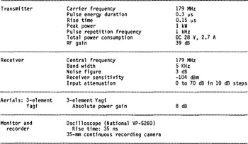
This sounder was designed to be Installed In the Pilatus Porter aircraft, thus limiting the available electric power and the dimensions of the aerials. The peak transmitter power was restricted to 1 kW, so the penetration depth of radio waves was about 1 500 m. The carrier frequency of 179 MHz was chosen because of the aerial length of 1 m and the Governmental frequency allocation. Details of the sounder were reported by Reference Wada and MaeWada and Mae (1981) and its specifications are listed in Table I.
SPECIFICATIONS OF NIPR-A SOUNDER
Since the aircraft fuselage does not allow sophisticated navigational instruments to be installed, the position of the aircraft was determined by map reading. Flights were planned to pass over as many known sites on nunataks or exposed rocks as possible, maintaining a constant altitude of about 3 000 m a.s.l. and a constant speed of about 90 knots. The errors of position were less than 3 km in the direction of flight and less than 1 km perpendicular to the flight line. On 28 January 1980, a flight of about 400 km was accomplished over the Yamato Mountains, taking two north-south and three east-west tracks (Fig.l); the next day the aircraft covered about 500 km over Shi rase Glacier, taking two longitudinal and four transverse tracks. To estimate the ice thickness the wave velocity was taken as 169 m us−1. The error in the estimation of the 1ce surface elevation is about 70 m and the ice thickness about 50 m.
Radio-echo sounding tracks in the Yamato Mountains region. Lines 1 to 5 are the airborne sounding tracks in 1980. A-, B-, and C-routes were the oversnow sounding routes in 1969-74. Many meteorites were found in the hatched areas. The shaded area shows the bare ice area.

3 Glaciological Features Of The Shirase Glacier
Figure 2 shows the flight track over Shi rase Glacier and its drainage basin on 29 January 1980. Oversnow traverses in Mizuho Plateau in 1969-74 revealed that Shlrase Glacier has a drainage area of 2xl05 km2 and an average thickness of 1 800 m (Reference Shimizu, Yoshimura, Naruse and YokoyamaShimizu and others 1978). Air photographs near the terminus have been taken intermittently and Landsat images covering the whole glacier have been available in recent years. Interpretation of these images showed that the width of the glacier near the coast is about 10 km, and that the ice tongue extends more than 50 km into Havsbotn in Lutzow-Holm Bay; a heavily crevassed region extends about 50 km inland. Reference FujiiFujii (1981) estimated an average ice thickness of 550 m and an average flow speed of 2 500 m a−1 from air photographs.
The echo sounding routes on Shirase Glacier and its drainage basin. C-route is the previous traverse route.

In analysing the records of radio echo-sounding of Shirase Glacier, Reference Wada and MaeWada and Mae (1981) found that no bottom echo was recorded from a heavily crevassed area up to 70°10'S and 39°00'E where the surface elevation is about 600 m. A conspicuous valley profile was observed both at the surface and sub-gladally near 70°20'S. They also discussed the absorption and scattering in the ice in analysing the continuous records and A-scope displays.
The airborne sounding flight crosses the C-route of the oversnow traverse by JARE-10 and JARE-14. From the results of the oversnow traverse, the ice thickness at C94 was found to be 1 794 m (surface elevation 1 800 m) and at C98 was 1 654 m (surface elevation 1 824 m). The airborne sounding results indicated that the ice thickness at C94 was 1 700 m and at C98 was 1 600 m.
4 Glaciological Features In The Vicinity Of The Yamato Mountains
4.1 Topography Of The Ice Sheet Near The Yamato Mountains
Reference Yoshida and FujiwaraYoshida and Fujiwara (1963) carried out a geomorphological survey of the Yamato Mountains area and reported that the ice sheet flows from east to west between several massifs. The surface elevation and ice thickness along A-, B-, and C-routes in Figure 1 and the surface velocity of the ice flow along the A-route the east of Motoi Nunatak were surveyed by JARE-10 and JARE-14 (Reference Naruse and YokoyamaNaruse and Yokoyama 1975, Reference NaruseNaruse 1978).
Figure 3 shows the continuous record of radio echosounding near Motoi Nunatak along route 1, which is the north-south flight in the eastern part of the Yamato Mountains where the surface elevation increases from 1 600 to 2 300 m. T, S, and R in Figure 3 indicate the transmitted wave, the echo from the ice surface, and the echo from the bedrock, respectively. Near the oversnow traverses, route 1 crosses two previously occupied sites, Bl and C 10, whose elevations were 2 242 and 1 768 m, respectively. The surface elevation deduced from the airborne sounding was 2 250 m at Bl and 1 775 m at C10. As shown in Figure 3, the echo from the bedrock was not obtained at several places where the ice thickness was assumed to be more than 1 500 m or the absorption of radio waves was large.
Continuous record near Motoi Nunatak along flight track 1 in the Yamato Mountains. Bl is shown in Figure 1. 'No echo region' shows the area where no bedrock echo was observed.

The surface and bedrock topography along the flight tracks is shown in Figure 4. As seen from tracks 3, 4, and 5 in Figure 4, the surface of the eastern side of the Yamato Mountains is about 500 m higher than that of the western side. In particular, the elevation of the sub-glacial topography west of 35°20'E is less than 1 000 m, but the elevation of the eastern sub-glacial uplands is more than 1 500 m. It is found that the glacier which flows between 71°25'S and 71°30'S is influenced by the bedrock elevation difference between the eastern side of 35°20'E and the western side.
The surface and bedrock topography obtained by airborne soundings along flight tracks in the Yamato Mountains.

4.2 Comparison Of Data Of Oversnow And Airborne Soundings
Figure 5 shows the bedrock and surface topography along route 5 obtained by airborne sounding. The solid circle shows the elevation of the bedrock obtained by the oversnow echo-sounding, which was reported by Reference Shimizu, Naruse, Omoto and YoshimuraShimizu and others (1972) who took the deepest echo as the reflection from the bedrock. Several echoes were tabulated by Reference Shimizu, Naruse, Omoto and YoshimuraShimizu and others (1972) and open circles indicate their shallowest positions. In a detailed examination of the airborne sounding record over B45, the reflection from the
The surface and bedrock topography along route 5. B43, B45, and C6 are the positions of previous oversnow sounding. The solid circle indicates the elevation of the bedrock obtained from surface sounding (Reference Shimizu, Naruse, Omoto and YoshimuraShimizu and others 1972) and open circles show bedrock elevation indicated by the shallowest echo in the report of Reference Shimizu, Naruse, Omoto and YoshimuraShimizu and others (1972).

bedrock coincides with the open circle, which is the shallowest echo in the report of Reference Shimizu, Naruse, Omoto and YoshimuraShimizu and others (1972). Comparison of airborne and oversnow soundings was made for other routes; in most cases, the shallowest echo from oversnow sounding should be interpreted as the reflection from the bedrock. Exceptionally in the case of C6 in Figure 5 the shallowest echo in the oversnow sounding did not indicate the bedrock. Probably the oversnow sounding was erroneous.
4.3 Bedrock Topography And Ice Flow In The Bare Ice Area Near Motoi Nunatak
A more detailed discussion will be given of glaciological features and bottom morphology of this area, combining data of oversnow traverses and airborne radio echo-soundings. From the airborne survey the surface elevation along routes 1 and 3 was obtained. JARE-10 and JARE-14 measured the surface elevation along A- and B-routes and the velocity vectors of surface flow along the A-route. On the basis of the surface traverses and airborne sounding data a contour map of the area near Motoi Nunatak is drawn (Fig.6). The flow lines are drawn from surface flow vectors and are perpendicular to the surface contours. In the shaded area in Figure 6 many meteorites have been collected. If the flow directions do not vary with depth, the meteorites are considered to be transported by the motion of ice sheet between flow lines LI and L2.
Contour map of ice surface elevation near Motoi Nunatak. Flow lines are shown by thick lines. Many meteorites were found in the shaded areas.
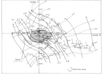
Figure 7 shows the bedrock elevations deduced from the airborne sounding of routes 1 and 3 and the oversnow radio echo soundings (on the A-route by JARE- 10 and JARE-14), where the ice thickness along Aroute was corrected for the shortest echo time. East of Motoi Nunatak three peaks create a high ridge, the Motoi Nunatak ridge. There are two peaks from 22 to 28 km east of Motoi Nunatak. From 12 to 20 km upstream of the Motoi Nunatak ridge there is an arc of a long and comparatively low ridge, called the Arched ridge. In view of the bedrock topography north of the Motoi Nunatak ridge, perhaps the Arched ridge may extend to the north-west as was shown by a dashed line in Figure 7 The depths of the valleys between the ridges was not estimated because of the sounding limitation of the NIPR-A. The flow lines in Figure 6 are also drawn in Figure 7. The area where meteorites were collected is shown by the shaded part in Figure 6 and is the up-stream part of the Motoi Nunatak ridge and under the lee of the Arched ridge.
Bedrock elevation near Motoi Nunatak. lines are shown by thick lines.

Figure 8 shows the south-east to north-west cross section along the line (S-S') in Figure 7. Figure 8 also shows the area where many meteorites were retrieved. The ice surface is comparatively flat near the Motoi Nunatak ridge and over the Arched ridge, but the surface inclination is large between them and also in the up-stream area of the Arched ridge. Reference NaruseNaruse (1978) estimated a vertical velocity of about 50 nm a−1 at the flat surface near the Motoi Nunatak, where meteorites were found, 70 mm a−1 over the Arched ridge, and 30 mm a−1 between the two flat surface areas. It appears, therefore, that up-welling motion is governed by the presence of ridges, and flow lines shown in Figure 8 may be reasonable.
The south-east to north-west cross-section near Motoi Nunatak along the line (S-S') as shown in Figure 7.

Many meteorites were found on the flat surface near Motoi Nunatak but very few on that over the Arched ridge even though the up-welling velocity is large in this area. If meteorites are distributed homogeneously in the ice mass, more meteorites should be found over the Arched ridge.
5 Conclusions
The bedrock and surface topography of Shi rase Glacier and the Yamato Mountains were obtained from the first airborne radio echo-sounding carried out by JARE-20 and -21.In particular the precise topography of the bedrock and surface in the area up-stream of Motoi Nunatak is investigated because previous oversnow traverses covered this area and many meteorites were found. It is planned to carry out more detailed airborne sounding in the Yamato Mountains, possibly starting in the 1982-83 field season.
Acknowledgements
The successful radio echo-sounding was due to the kind help rendered by Messrs M Yamaguchi, T Mizushima, T Yashiro, and H Omori, members of JARE-21 led by Professor S Kawaguchi. The authors are indebted to Professor K Kusunoki, NIPR, who kindly reviewed and discussed the paper.



