INTRODUCTION
Coastal areas connect the continents and oceans where sedimentation is controlled by the interaction of monsoonal, fluvial, and marine processes (Dalrymple and Choi, Reference Dalrymple and Choi2007; Clift and Jonell, Reference Clift and Jonell2021). Over geological time, global climate change, sea-level fluctuations, and terrestrially derived sediment input are recorded by the stratigraphy preserved in these areas (Clift, Reference Clift2006). Therefore, detailed studies of the sediments deposited at continental margins can provide a better understanding of paleoclimatic and paleoenvironmental changes, as well as the evolution of large rivers (e.g., Miller et al., Reference Miller, Kominz, Browning, Wright, Mountain, Katz, Sugar, Cramer, Christie-Blick and Pekar2005; Parham et al., Reference Parham, Riggs, Culver, Mallinson, Rink and Burdette2012; Ridente et al., Reference Ridente, Petrungaro, Falese and Chiocci2012; McCarthy et al., Reference McCarthy, Katz, Kotthoff, Browning, Miller, Zanatta and Williams2013; Liu et al., Reference Liu, Wang, Wang, Qiu, Saito, Lu, Zhou, Xu, Du and Chen2016; Yao et al., Reference Yao, Shi, Qiao, Liu, Kandasamy, Liu, Liu, Fang, Gao and Dou2017).
The Yellow River is one of the largest rivers in the world (Qin et al., Reference Qin, Zhao, Chen and Zhao1990), and has attracted significant scientific interest due to its ecological and economic importance. Numerous studies have investigated the evolution of the Yellow River (e.g., Clark et al., Reference Clark, Schoenbohm, Royden, Whipple, Burchfiel, Zhang, Tang, Wang and Chen2004; Liu and Sun, Reference Liu and Sun2007; Kong et al., Reference Kong, Jia and Zheng2014; Zhang et al., Reference Zhang, Wan, Clift, Huang, Yu, Zhang and Mei2019; Xiao et al., Reference Xiao, Sun, Yang, Yin, Dupont-Nivet, Licht and Kehew2020, Reference Xiao, Pan, Zhao, Yin, Chen, Ao, Li and Zhu2021). Nevertheless, the precise age of the final emergence of the Yellow River to the ocean, and its effect on the marginal sea are unclear. For example, fluvial terraces of the Sanmen Gorge suggest that integration of the Yellow River occurred in the Early Pleistocene (e.g., Pan et al., Reference Pan, Wang, Gao, Guan, Wang, Su, Li and Li2005; Kong et al., Reference Kong, Jia and Zheng2014; Hu et al., Reference Hu, Li, Dong, Guo, Bridgland, Pan, Li and Liu2019; Liu, Reference Liu2020). It is noteworthy that the sedimentary sequence of DR01 core in the Hetao Graben indicates that there was an ancient Yellow River at least since 1.7 Ma (Li et al., Reference Li, Sun, Xu, Wang, Liang, Ma, Wang, Li and Chen2017). Through consideration of the similarity in the sedimentary facies throughout the DR01 core and sedimentary characteristics of the Neogene conglomerates along the Jinshaan Gorge, the Yellow River may have existed at least since the late Neogene (Xiong et al., Reference Xiong, Liu, Zhang, Deng, Picotti, Wang and Zhang2022), which is much earlier than 1.7 Ma. In addition, an abrupt increase in the rate of accumulation of loess deposits in the Mangshan section and the drying up of the Sanmen paleolake are observed and interpreted to indicate downcutting of the Sanmen Gorge and full development of the Yellow River at 0.24–0.15 Ma (Jiang et al., Reference Jiang, Fu, Wang, Sun and Zhao2007). This large range of ages may reflect the complexity of Yellow River evolution, which needs further investigation.
After the final integration of the Yellow River, the mouth of the Yellow River has moved several times between the Bohai and Yellow seas (Ren and Shi, Reference Ren and Shi1986; Ren, Reference Ren2015). Provenance analysis of sediments deposited in coastal areas may provide insights into the effects of the Yellow River on the marginal seas of China. Radiogenic Sr, Nd, and Pb isotopes have been used extensively as tracers of sediment sources (e.g., Parra et al., Reference Parra, Faugeres, Grousset and Pujol1997; Choi et al., Reference Choi, Yi, Yang, Lee and Cha2007; Jiang et al., Reference Jiang, Xiong, Frank, Yin and Li2019). Although the Sr isotope data are influenced by grain size, Nd isotopes are largely unaffected by mineral sorting and grain size (Chen et al., Reference Chen, Li, Yang, Rao, Lu, Balsam, Sun and Li2007). Clay minerals are also sensitive to climate change and can reveal the paleogeographic and stratigraphic history of depositional sequences (Biscaye et al., Reference Biscaye, Grousset, Revel, Van der Gaast, Zielinski, Vaars and Kukla1997; Thiry, Reference Thiry2000). Provenance analyses of sediments in the Bohai and South Yellow seas have shown that sediment provenance has been dominated by the Yellow River since 0.9–0.8 Ma (Yao et al., Reference Yao, Shi, Qiao, Liu, Kandasamy, Liu, Liu, Fang, Gao and Dou2017; Zhang et al., Reference Zhang, Wan, Clift, Huang, Yu, Zhang and Mei2019). However, single-grain zircon ages from three well-dated late Miocene–Pleistocene boreholes in the lower Yellow River floodplain suggest that the upstream and downstream parts of the Yellow River were connected between 1.6–1.5 Ma (Xiao et al., Reference Xiao, Sun, Yang, Yin, Dupont-Nivet, Licht and Kehew2020). This is also supported by detrital zircon U-Pb geochronology and geochemical signals from borehole G4 in the Bohai bay, which show the Yellow River entered the Bohai Bay since ca. 1.6 Ma (Yang et al., Reference Yang, Yuan, Hu and Wang2022). Yet it is noteworthy that zircon can survive multiple cycles of sediment recycling because of its erosion resistance, and therefore may not always represent the most recent phase of sediment transport (Bird et al., Reference Bird, Millar, Rodenburg, Stevens, Rittner, Vermeesch and Lu2020). Furthermore, forcing mechanisms for the final integration of the Yellow River are still debated, including climate-driven lake expansion (Craddock et al., Reference Craddock, Kirby, Harkins, Zhang, Shi and Liu2010; Yao et al., Reference Yao, Shi, Qiao, Liu, Kandasamy, Liu, Liu, Fang, Gao and Dou2017), tectonic processes (Lin et al., Reference Lin, Yang, Sun and Yang2001; Zhang et al., Reference Zhang, Wan, Clift, Huang, Yu, Zhang and Mei2019), and fluvial erosion triggered by Plio-Pleistocene base level fluctuations (Xiao et al., Reference Xiao, Sun, Yang, Yin, Dupont-Nivet, Licht and Kehew2020). Therefore, detailed provenance studies of coastal areas of eastern China constrained by precise age models are essential for the timing and mechanism of the final emergence of the Yellow River.
In this study, a 200-m-long core (YRD-1101) was recovered from the modern Yellow River delta on the southwest coast of Bohai Sea. The heavy mineral assemblages in this core (i.e., the epidote to hornblende ratio) revealed that the Yellow River first flowed into the modern Yellow River delta at ca. 0.83 Ma (Liu et al., Reference Liu, Zhang, Miao, Xu and Wang2020). However, the relative abundances of heavy minerals are strongly affected by the hydrodynamic conditions during sediment transport (Morton and Hallsworth, Reference Morton and Hallsworth1999), which limit their ability to constrain the sediment provenance. Given the complexity of the evolution of the Yellow River, more studies of sedimentary records around the Bohai Sea are needed. In this regard, we focused on temporal variations in grain size, clay mineral assemblages, and Sr-Nd-Pb isotopes of the <63 μm silicate sediment fraction in the YRD-1101 core. These data provide new evidence for provenance changes during the last ca. 1.9 Ma.
REGIONAL SETTING
The Bohai Sea comprises the Liaodong Bay, Bohai Bay, Laizhou Bay, Central Basin, and Bohai Strait, with a total area of 78,000 km2. The average water depth and slope are 18 m and 0.0078°, respectively (Qin et al., Reference Qin, Zhao, Chen and Zhao1990). Water enters the Bohai Sea through the northern Bohai Strait and flows out along the southern margin of the Bohai Sea. Circulation in Liaodong Bay forms a clockwise gyre in winter, and counterclockwise gyre in summer (Dou et al., Reference Dou, Li, Zhao, Wei, Yang, Bai, Zhang, Ding and Wang2014). The tidal regime in the Bohai Sea is dominated by semi-diurnal tides (Qin et al., Reference Qin, Zhao, Chen and Zhao1990).
The Yellow River is the second longest river in China, with an estimated length of 5464 km and a watershed area of 7,520,000 km2. It originates in the southern part of Qinghai Province on the Tibetan Plateau and crosses the dry Loess Plateau of North China as it flows towards the Bohai Sea. It was estimated that the Yellow River delivered 1.1 × 10⁹ ton/yr of sediment to the sea (Milliman et al., Reference Milliman, Qin, Ren and Saito1987), with 43% of that deposited in the delta (Milliman and Meade, Reference Milliman and Meade1983). However, the sediment load has decreased abruptly to 1.5 × 10⁸ tons/year over the last 20 years because of natural and anthropogenic changes (Wang et al., Reference Wang, Yang, Saito, Liu, Sun and Wang2007). When the Yellow River changed its course from the South Yellow Sea to the Bohai Sea, the modern Yellow River delta (118.0–119.5°E, 37.0–38.5°N) was formed (Liu et al., Reference Liu, Saito, Wang, Zhou and Yang2009; Ren, Reference Ren2015). The modern Yellow River delta, which has prograded seaward by >40 km in the last 150 yr, presently has an area of ~5000 km2 (e.g., Liu et al., Reference Liu, Saito, Wang, Zhou and Yang2009; Hu et al., Reference Hu, Li, Li, Bi, Zhao and Bu2012).
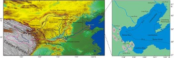
In addition to the Yellow River, the Bohai Sea also has received sediment from other small rivers (Fig. 1). The Luan River, which is 877 km long (He et al., Reference He, Amorosi, Ye, Xue, Yang and Laws2020), originates from Bayan Tugur Mountain and flows to the sea through the Inner Mongolia Plateau and Yanshan Mountains. The length and drainage area of the Liao River are 1400 km and 220,000 km2, respectively (Milliman and Farnsworth, Reference Milliman and Farnsworth2011). The Hai River system, including the Yongding River, Daqing River, and Ziya River, has a drainage area of 210,000 km2 and discharged more than 8.0 × 10⁶ ton/yr sediments to the Bohai Sea before the 1950s (Qin et al., Reference Qin, Mei, Jiang, Luan, Zhou and Zhu2021). Furthermore, the sediment discharge of the Daling (1.77 × 10⁷ ton/yr) and Xiaoling (2.24 × 10⁶ ton/yr) rivers is also significant, although both are small scale in terms of their lengths and catchment areas (Qin et al., Reference Qin, Mei, Jiang, Luan, Zhou and Zhu2021).
Location of the Yellow River and study area. Dashed red line indicates the Yellow River's drainage area, including its tributaries and the locations mentioned in the text. The gray areas (numbered 1–8, 10, from oldest to youngest) represent nine superlobes formed in the west coast of the Bohai Sea since the Holocene (the superlobe represented by gray area 9 is not shown because it is located in northern Jiangsu Province rather than in the study area). Left side of Figure 1 is modified from Nie et al. (Reference Nie, Stevens, Rittner, Stockli, Garzanti, Limonta and Bird2015).

MATERIALS AND METHODS
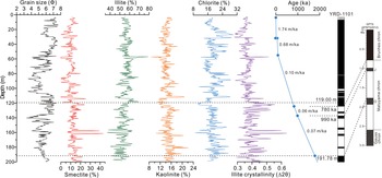
The YRD-1101 core (38°02′08.97″N, 118°36′25.88″E; length 200.30 m) was drilled in the modern Yellow River delta using the rotary method in July 2011 (Fig. 1). The core had a mean recovery of 85%. The lithological characteristics show that the core is dominated by fluvial, tidal-flat, littoral, and coastal deposits (Liu et al., Reference Liu, Wang, Wang, Qiu, Saito, Lu, Zhou, Xu, Du and Chen2016). The chronological framework of the core was established by magnetostratigraphy, seven accelerator mass spectrometry (AMS) 14C dates, and 20 optically stimulated luminescence (OSL) dates (Sun et al., Reference Sun, Liu, Qiu, Li and Xiang2014; Liu et al., Reference Liu, Wang, Wang, Qiu, Saito, Lu, Zhou, Xu, Du and Chen2016). Paleomagnetic analyses show that the upper boundary of the Jaramillo subchron was at 136.21 m, and the Brunhes/Matuyama (B/M) chron boundary was at 123.33 m (Liu et al., Reference Liu, Wang, Wang, Qiu, Saito, Lu, Zhou, Xu, Du and Chen2016). The age model was constrained by these control points and linear extrapolations of the sedimentation rates. The basal age of YRD-1101 core was estimated to be ca. 1.9 Ma by the upper boundary of the Olduvai subchron at 191.78 m and extrapolation of the average sedimentation rate of 70 m/Ma (i.e., 0.07 m/ka; from 191.78–136.21 m in Figure 2).
Variations in clay mineral assemblage, illite crystallinity, and sediment accumulation rate in the YRD-1101 core since 1.9 Ma. The magnetostratigraphy (Liu et al., Reference Liu, Wang, Wang, Qiu, Saito, Lu, Zhou, Xu, Du and Chen2016), Geomagnetic Polarity Timescale (GPTS), and Astronomically Tuned Neogene Time Scale 2012 (ATNTS 2012) (Hilgen et al., Reference Hilgen, Lourens, Van Dam, Gradstein, Ogg, Schmitz and Ogg2012) are shown for comparison. The “ka” denotes “kyr B.P.” Dashed black line indicates significant change in provenance at ~119 m core depth. Solid blue line indicates sedimentation rate and solid blue dots indicate reliable ages that were obtained by magnetostratigraphy, AMS 14C, and OSL dating; the age model in core YRD-1101 was constrained by these control points and linear extrapolations of the sedimentation rates.

In this study, 377 samples were selected for clay mineral analysis. For sample pre-treatment, organic and carbonate phases were removed with 10% H2O2 and 0.5 M HCl, respectively. The clay fractions (<2 μm) were extracted and transferred to two slides by wet smearing and then air-dried. Clay minerals were identified by X-ray diffraction (XRD) with a Rigaku D/max-2500 diffractometer using Cu-Kα radiation (40 kV and 100 mA) at the Qingdao Institute of Marine Geology, Qingdao, China. The relative percentages of clay minerals were calculated following the methods of Biscaye (Reference Biscaye1965) and Biscaye et al. (Reference Biscaye, Grousset, Revel, Van der Gaast, Zielinski, Vaars and Kukla1997), with an error of ± 8–10%.
Thirty-four samples of the <63 μm silicate fraction were selected for Sr-Nd-Pb isotope analysis at the Key Laboratory of Marine Sedimentology and Environmental Geology, First Institute of Oceanography, State Oceanic Administration, Qingdao, China. Prior to analysis, the samples were treated with HCl and H2O2 and then digested in high-pressure Teflon bombs using a HCl + HNO3+HClO4+HF solution. The Sr and Nd isotope ratios were determined with a Nu Plasma high-resolution inductively coupled plasma mass spectrometer after Sr and Nd separation. Lead was separated using successive acid elution on an anion exchange resin (AG1-X8) column. The separation and analysis of Pb isotopes were undertaken using the methods of Hu et al. (Reference Hu, Li, Li, Bi, Zhao and Bu2012). Analytical precision of the Sr, Nd, and Pb isotope data were monitored by analysis of the standards NBS 987 (87Sr/86Sr = 0.710310 ± 0.00003), JNdi-1 (143Nd/144Nd = 0.512115 ± 0.000007), and NIST SRM 981 (208Pb/204Pb = 36.674 ± 0.004, 207Pb/204Pb = 15.486 ± 0.003, and 206Pb/204Pb = 16.933 ± 0.003; 2σ), respectively. Neodymium isotope data are expressed as εNd = [(143Nd/144Ndsample)/(143Nd/144NdCHUR) − 1] × 10,000, where the CHUR (i.e., the chondritic uniform reservoir) value is 0.512638 (Jacobsen and Wasserburg, Reference Jacobsen and Wasserburg1980).
RESULTS
Clay mineralogy
In the YRD-1101 core, illite (37.0–79.1%) is the dominant clay mineral, with an average percentage of 55.6%. Smectite (0–43.4%; average = 11.2%), kaolinite (8.7–22.2%; average = 14.5%), and chlorite (9–30%; average = 18.7%) are present in the samples in lesser amounts. Down-core variations in the clay mineral assemblage are shown in Figure 2. Smectite and kaolinite contents decrease slightly from bottom to top of the core, whereas illite exhibits the opposite trend.
From 200.30–119.00 m, the relative percentages of illite show an increasing pattern generally, and the trends in kaolinite contents are similar to chlorite, which fluctuate slightly and are relatively stable. In addition, the illite crystallinity values, which range from 0.294–0.636, exhibit clear fluctuations around a value of 0.4. In this section, smectite contents show a stable trend overall except for few abnormally high values at ~160 m. Notably, a significant boundary can be identified at a depth of 119.00 m, where the content of smectite decreases from 12.7% to 1.9% and the content of illite increases from 57.8% to 69.3%. In the uppermost 119.00 m, the average content of smectite decreases from 13.6% to 9.6%, while that of illite increases 53.0% to 57.3%. Meanwhile, distinct fluctuations in the clay mineral assemblages are evident, especially for chlorite. Some changes in illite crystallinity values are also observed. The illite crystallinity values overall are relatively low and vary between 0.279–0.513, with most values being <0.4 during this period.
Sr-Nd-Pb isotopic compositions
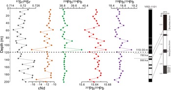
Down-core variations of the Sr-Nd-Pb isotope ratios are shown in Figure 3 and Supplemental Table S1. 87Sr/86Sr ratios vary between 0.71555–0.72543 and 143Nd/144Nd ratios range from 0.511809–0.512107 (εNd = −16.13 to −10.36). In addition, 208Pb/204Pb, 207Pb/204Pb, and 206Pb/204Pb ratios vary from 38.8–40.4, 15.60–15.68, and 18.4–19.2, respectively (Supplemental Table S1). Similar to the clay minerals, a change in these isotope ratios occurs at ~119.00 m.
Variations of 87Sr/86Sr, εNd, and Pb isotope values in the YRD-1101 core during the last 1.9 Ma.

From 200.30–119.00 m, the εNd and Pb isotope ratios (208Pb/204Pb, 207Pb/204Pb, and 206Pb/204Pb) are relatively low and uniform with limited variation, whereas the 87Sr/86Sr ratios are reversed. In the uppermost (≤119.00 m) part of the core, εNd and 87Sr/86Sr ratios display a long-term increasing trend, and the Pb isotope ratios vary synchronously and exhibit large variations (Fig. 3).
Based on the changes in clay mineral assemblages, illite crystallinity, and Sr-Nd-Pb isotopic compositions, a boundary is observed at ~119.00 m. The depth of 119.00 m is only 4.33 m above the B/M boundary, and the age at this depth (~119.00 m) is estimated to be ca. 0.71 Ma by extrapolation of the average sedimentation rate of 61 m/Ma (i.e., 0.06 m/ka; from 136.21–123.33 m; Fig. 2).
DISCUSSION
Variations in sediment sources in the YRD-1101 core
Knowledge of the potential sediment sources is necessary to assess the sediment provenance in the YRD-1101 core. Due to heavy rainfall and intense human activities, the Yellow River and some other small rivers contribute large amounts of sediment to the Bohai Sea, which has a large effect on the sedimentary system in the coastal-shelf areas of eastern China. Compared with the Yellow River, the other small rivers around the Bohai Sea (e.g., the Hai, Daling, and Liao rivers) discharge a combined average of 7.5 × 10⁷ ton/yr of sediment (Qin et al., Reference Qin, Mei, Jiang, Luan, Zhou and Zhu2021). At present, the sediments in the modern Yellow River delta are mainly supplied by the Yellow River (Liu et al., Reference Liu, Saito, Wang, Zhou and Yang2009), with minor amounts of sediment delivered from local rivers, such as the Hai, Xiaoqing, and Wei rivers (Fig. 1).
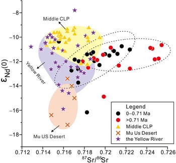
Given the unique mineralogical and geochemical signatures of these potential sources, Sr-Nd isotopic compositions of detrital sediment fractions can reliably trace and be used to identify changes in sediment provenance (e.g., Parra et al., Reference Parra, Faugeres, Grousset and Pujol1997; Choi et al., Reference Choi, Yi, Yang, Lee and Cha2007; Yang et al., Reference Yang, Jiang, Ling, Xia, Sun and Wang2007; Steinke et al., Reference Steinke, Hanebuth, Vogt and Stattegger2008; Sun and Zhu, Reference Sun and Zhu2010; Rao et al., Reference Rao, Shynu, Singh, Naqvi and Kessarkar2015). 87Sr/86Sr versus ɛNd(t) is plotted in Figure 4. For comparison purposes, the cited 87Sr/86Sr and εNd data from previously published studies were measured using <63 μm or <75 μm fractions. Unfortunately, Sr-Nd isotope data for other rivers surrounding the Bohai Sea are unavailable. Our data for samples younger than 0.71 Ma overlap those for the modern Yellow River and middle Chinese Loess Plateau (CLP). In contrast, most of our data for samples older than 0.71 Ma deviate to some extent from the Yellow River sediment field, indicating contributions from other sediment sources. In addition, relatively low isotope ratios of Pb, which fluctuate within narrow range of values (Fig. 3), are observed in sediments older than 0.71 Ma. This may be caused by large amounts of multi-sourced sediment inputs, which might have complicated the Pb isotopic compositions (Yao et al., Reference Yao, Shi, Qiao, Liu, Kandasamy, Liu, Liu, Fang, Gao and Dou2017). However, few data are available in previous studies to characterize the potential sources. After that, clear variations in the Pb isotopic ratios are observed in the uppermost 119.00 m (Fig. 3), although this changing tendency is not easy to distinguish due to the low-resolution sampling.
Plot of Sr-Nd isotope data used for sediment provenance discrimination. Also shown are Sr and Nd isotope data for sediments from the Yellow River (Meng et al., Reference Meng, Liu, Shi and Du2008; Rao et al., Reference Rao, Chen, Tan, Jiang and Su2011, Reference Rao, Mao, Wang, Huang and Ji2017; Jiang et al., Reference Jiang, Xiong, Frank, Yin and Li2019), middle Chinese Loess Plateau (CLP) (Liu et al., Reference Liu, Masuda, Okada, Yabuki and Fan1994; Gallet et al., Reference Gallet, Jahn and Torri1996; Jahn et al., Reference Jahn, Gallet and Han2001; Chen et al., Reference Chen, Li, Yang, Rao, Lu, Balsam, Sun and Li2007; W.B. Rao et al., Reference Rao, Chen, Yang, Ji, Li and Tan2008; Yang et al., Reference Yang, Li, Dai, Rao and Ji2009), and Mu Us desert (W.B. Rao et al., Reference Rao, Chen, Yang, Ji, Li and Tan2008).

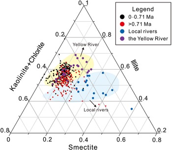
Clay mineral assemblages can provide additional constraints on the sediment provenance and paleoclimatic changes (Ehrmann et al., Reference Ehrmann, Schmiedl, Hamann, Kuhnt, Hemleben and Siebel2007; Adriaens et al., Reference Adriaens, Zeelmaekers, Fettweis, Vanlierde, Vanlede, Stassen, Elsen, Środoń and Vandenberghe2018). Most Yellow River-derived sediments are eroded from the Chinese Loess Plateau (Wang et al., Reference Wang, Yang, Saito, Liu, Sun and Wang2007), and the loess deposits have no significant variations in clay mineral composition (Zhang et al., Reference Zhang, Wan, Clift, Huang, Yu, Zhang and Mei2019). Figure 5 shows a smectite, (illite + chlorite), kaolinite ternary diagram, on which our data are plotted along with modern river data. Almost all samples younger than 0.71 Ma plot close to the modern Yellow River field. In contrast, samples older than 0.71 Ma plot between the modern Yellow River field and those for some mountainous rivers surrounding the Bohai Sea. Therefore, sediments older than 0.71 Ma were primarily sourced from the Yellow River, but with additions from some local rivers (e.g., the Liao, Wei, Liugu, Daling, and Xiaoling rivers). Similar results have been reported for the sediments in BH08 core (Yao et al., Reference Yao, Shi, Qiao, Liu, Kandasamy, Liu, Liu, Fang, Gao and Dou2017).
Ternary diagram of smectite, illite, and kaolinite + chlorite contents in the YRD-1101 core. The Yellow River and other local rivers end-member sources of sediment are represented by yellow and blue areas, respectively.

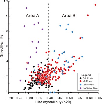
Figure 2 shows that the average smectite content decreased from 13.6% to 9.6% at ~119.00 m. Compared with the dominance of illite in sediments of the Yellow River, the mountainous rivers around the Bohai Sea contain higher smectite contents than the Yellow River (Dou et al., Reference Dou, Li, Zhao, Wei, Yang, Bai, Zhang, Ding and Wang2014; Yao et al., Reference Yao, Shi, Qiao, Liu, Kandasamy, Liu, Liu, Fang, Gao and Dou2017), indicating the provenance changed from multiple sources to one dominated by the Yellow River. Furthermore, the illite crystallinity values are usually higher (>0.4) in sediments derived from the local rivers (e.g., the Liao, Daling, and Xiaoling rivers) as compared with sediments derived from the Yellow River (Dou et al., Reference Dou, Li, Zhao, Wei, Yang, Bai, Zhang, Ding and Wang2014). The illite crystallinity values generally vary from 0–0.4 in the upper section (0–119.00 m) and 3.7–5.0 in the lower section (119.00–200.30 m) (Fig. 2). Figure 6 shows a tendency that almost all the samples younger than 0.71 Ma plot in the Yellow River field, although several samples have higher illite crystallinity values (>0.4) and overlap with the sediment field for local rivers. This phenomenon further demonstrates a significant increase in discharge of Yellow River sediments after 0.71 Ma.
Plot of smectite/illite versus the illite crystallinity for the YRD-1101 core. The sediment sources of the Yellow River and local rivers around the Bohai Sea are represented by Area A and Area B, respectively. Note that almost all the samples younger than 0.71 Ma plot in Area A, although several samples have higher illite crystallinity values (>0.4) and plot in Area B.

Our results suggest that the sediments delivered to the study site were mainly derived from the Yellow River and some local rivers surrounding the Bohai Sea prior to 0.71 Ma. A significant increase in Yellow River sediments delivered to the study area has occurred since ca. 0.71 Ma, when the provenance became dominated by the Yellow River.
Factors driving the provenance changes since 1.9 Ma
The ages and origins of sediments deposited in coastal area of the Bohai Sea are important for constraining the timing and mechanisms of the final emergence of the Yellow River. Based on new detrital-zircon evidence from the North China Plain (Xiao et al., Reference Xiao, Sun, Yang, Yin, Dupont-Nivet, Licht and Kehew2020; Yang et al., Reference Yang, Yuan, Hu and Wang2022), coupled with the characteristics of heavy minerals and sedimentary structures of terrace gravel layers along the Yellow River (Hu et al., Reference Hu, Li, Dong, Guo, Bridgland, Pan, Li and Liu2019), current data do not provide support for the hypothesis that full integration of the Yellow River occurred in the late Pleistocene (Jiang et al., Reference Jiang, Fu, Wang, Sun and Zhao2007; Zheng et al., Reference Zheng, Huang, Ji, Liu, Zeng and Jiang2007). This is also supported by geochemical evidence in the CSDP-1 core, which suggests a shift of sediment provenance in the South Yellow Sea from the Yangtze to the Yellow River during 1.7–1.5 Ma (Huang et al., Reference Huang, Mei, Yang, Zhang, Li and Hohl2021). The clay mineral assemblages and Sr-Nd-Pb isotope record in YRD-1101 core suggest that sediments along the western coast of the Bohai Sea were mainly delivered by the Yellow River and some local rivers surrounding the Bohai Sea during 1.9–0.71 Ma, implying that the Yellow River may have influenced the Bohai Sea since 1.9 Ma. From a comparative perspective, our new data extend the age of integration of the Yellow River to ever older times.
Geochronology and tectonic geomorphology studies have demonstrated that a recent uplift of the Tibetan Plateau (i.e., Kunlun-Huanghe movement) occurred between 1.2–0.8 Ma (Shi, Reference Shi1998; Liu and Sun, Reference Liu and Sun2007; Li et al., Reference Li, Fang, Song, Pan, Ma and Yan2014; Zhang et al., Reference Zhang, Zhang, Song, Erwin, Mao, Fang and Lu2017), which has been regarded as the first-order control on integration of the Yellow River sediments (Zhang et al., Reference Zhang, Wan, Clift, Huang, Yu, Zhang and Mei2019). However, our data indicate that the Yellow River influenced the Bohai Sea much earlier than 1.2 Ma, implying that the tectonic geomorphological pattern of the Yellow River basin was established prior to the Early Pleistocene.
It is also noted that sediment contribution from the Yellow River has increased significantly since 0.71 Ma in the YRD-1101 core, which provides new insights into the evolution of the Yellow River. Subsidence of the eastern China coast in the past 1.0 Ma was significant, which provides a basis for the generation of accumulation space for influx of sediment (Cosgrove et al., Reference Cosgrove, Colombera and Mountney2022). For instance, previous studies have revealed that seawater entered the Bohai Sea due to accelerated subsidence of the basins in the Bohai and South Yellow seas since ca. 0.83 Ma (Liu et al., Reference Liu, Wang, Wang, Qiu, Saito, Lu, Zhou, Xu, Du and Chen2016, Reference Liu, Zhang, Mei, Zhao, Guo, Zhao and Liu2018). Sediment loading from the Yellow River, in turn, affects basin subsidence and, consequently, the rate of sediment accumulation.
Additionally, the orbital obliquity cycles of 41 ka were superseded by 100 ka cycles during the Middle Pleistocene Transition (Mudelsee and Schulz, Reference Mudelsee and Schulz1997), and stronger climatic oscillations and longer glacial-interglacial cycles developed (Maslin and Brierley, Reference Maslin and Brierley2015). The amplitude of the 100 ka cycles has generally increased since 0.9 Ma and became largest at ca. 0.7 Ma (Berger et al., Reference Berger, Yasuda, Bickert, Wefer and Takayama1994). The lowstand sea-level drop during glacial periods also could have induced increased river incision and morphological instability (Gibbard and Lewin, Reference Gibbard and Lewin2009; Head and Gibbard, Reference Head and Gibbard2015). Continuous subsidence of the Bohai Basin, along with the sea-level oscillations associated with climate change in the last 1.0 Ma, caused an increase in the fluvial gradient and intensification of sedimentary dynamics (Humphrey and Konrad, Reference Humphrey and Konrad2000; Dauteuil et al., Reference Dauteuil, Bessin and Guillocheau2015; Yi et al., Reference Yi, Deng, Tian, Xu, Jiang, Qiang and Qin2016; Xiao et al., Reference Xiao, Sun, Yang, Yin, Dupont-Nivet, Licht and Kehew2020). More importantly, the Quaternary glacial-interglacial cycles and supply of proximal sources also led to the rapid increase in loess sedimentation since ca. 1.0 Ma (Guo et al., Reference Guo, Ruddiman, Hao, Wu, Qiao, Zhu, Peng, Wei, Yuan and Liu2002; Nie et al., Reference Nie, Stevens, Rittner, Stockli, Garzanti, Limonta and Bird2015; Xiong et al., Reference Xiong, Zhang, Zhao, Liu, Li and Zhang2021), which could be the key reasons for the increase of Yellow River sediments in the Bohai Basin. This is supported by the age-depth curve (Fig. 2), which shows that the rate of sediment accumulation has increased significantly since ca. 0.71 Ma.
In summary, we propose a two-stage evolutionary model for the development of the Yellow River. On the one hand, we hypothesize that the Yellow River has influenced the Bohai Sea since 1.9 Ma (or even earlier). Considering that the Sanmen Gorge may have been shallow and narrow at the early stage of its incision (Xiao et al., Reference Xiao, Sun, Yang, Yin, Dupont-Nivet, Licht and Kehew2020), it is unlikely that the Yellow River could have delivered large amounts of sediment to the Bohai Sea. On the other hand, with continuing subsidence of the eastern China coast, large-amplitude sea-level changes, and increased supply of eroded loess during the last 1.0 Ma (Berger et al., Reference Berger, Yasuda, Bickert, Wefer and Takayama1994; Head and Gibbard, Reference Head and Gibbard2015), incision of the Yellow River has intensified. The Sanmen Gorge became deeper and wider, which intensified the delivery of Yellow River sediments into the Bohai Sea. Our data suggest significantly increased discharge of Yellow River sediments into the study area since 0.71 Ma in YRD-1101, indicating that the contribution of local rivers surrounding the Bohai Sea became negligible due to dilution by the huge amounts of Yellow River sediments. It should be noted that large-scale channel shifting of the Yellow River was observed on the Huabei Plain during the Chinese history (Xue et al., Reference Xue, Zhou and Wang2003; He et al., Reference He, Xue, Ye, Amorosi, Yuan, Yang and Laws2019), which may have contributed to the possible lag between 1.0 Ma and 0.71 Ma. Interestingly, this significant increase in sediment discharge post-dated the change in the heavy mineral assemblages of the same core (0.83 Ma; Liu et al., Reference Liu, Zhang, Miao, Xu and Wang2020). Given that heavy mineral assemblages also can be affected by hydrodynamic conditions during sediment transport (Morton and Hallsworth, Reference Morton and Hallsworth1999), we suggest that the timing of provenance change obtained from the heavy mineral assemblages may be less reliable.
CONCLUSIONS
The Sr-Nd-Pb isotopic composition and clay mineralogy of the YRD-1101 core from the modern Yellow River delta were used to determine the sediment provenance and development of the Yellow River, which leads to two main conclusions. (1) The YRD-1101 core is divided into two intervals with a boundary between the two at 119.00 m (corresponding to an age of 0.71 Ma). Clay mineralogy and Sr-Nd-Pb isotope data for samples overlap those for the modern Yellow River in the upper interval, whereas they deviate to some extent from the Yellow River sediment field in the lower interval. (2) Sediments along the western coast of the Bohai Sea were mainly delivered by the Yellow River and some local rivers surrounding the Bohai Sea during 1.9–0.71 Ma, implying that the Yellow River may have influenced the Bohai Sea since 1.9 Ma. A significant increase in discharge of Yellow River sediments into the study area has occurred since 0.71 Ma, with the provenance now dominated by the Yellow River.
Supplementary Material
The supplementary material for this article can be found at https://doi.org/10.1017/qua.2022.64
Acknowledgments
We are grateful to the editors and anonymous reviewers for their constructive comments on our manuscript.
Financial Support
This research was funded by the National Natural Science Foundation of China (Grant No. 41330964) and Natural Science Foundation of Shandong Province, China (Grant No. ZR2020MD069). This research was also funded by the China Geological Survey Projects (Grant No. DD20221724).