

INTRODUCTION
China has a vast population and little land per capita, and much attention has been focused on food production, both in political and academic circles, since 1949 (Yang & Li Reference Yang and Li2000; Li & Wang Reference Li and Wang2003). Following the reforms in 1978, China has experienced rapid economic development, resulting in a significant loss of cultivated land to urbanization (Li & Wang Reference Li and Wang2003; Deng et al. Reference Deng, Huang, Rozelle and Uchida2006). In addition to a rising demand for agricultural products, China faces serious challenges in food production given the remaining arable land, with the aim of ensuring sufficient food for all inhabitants and a fair standard of living for people involved in agriculture (Verburg et al. Reference Verburg, Chen and Veldkamp2000; Zhang et al. Reference Zhang, Yu, Li, Zhou and Zhang2007).
Even though the area available for growing cereals has declined in China over recent decades, the total production has actually increased by 20% due to increases in cereal yield per hectare (Paarlberg Reference Paarlberg1997). Over the last 50 years, China has seen remarkable growth in food production, with an increase of more than 3-fold per capita (Royal Society 2009). This growth may be attributed to the Chinese intensive cropping and arable land use, which can be characterized as an increase of cropping frequency, inputs, material application and labour. Over the past two decades in particular, China has introduced high yields and external inputs that require production technologies from Western countries, to complement its traditional production technologies and practices (Zhen et al. Reference Zhen, Routray, Zoebisch, Chen, Xie and Cheng2005). Intensive land use has been the major strategy established by the Chinese government to secure adequate livelihoods for the population. Therefore, agricultural land intensification throughout China has been one of the most significant instances of land cover modification in the past two decades. Meanwhile, economic growth in different regions has substantially varied since the reform. The magnitude of changes in cultivated land that has accompanied this spatially uneven economic growth has varied across regions and provinces (Yang & Li Reference Yang and Li2000). However, the production increases achieved must be sustainable by minimizing negative environmental effects and, of equal importance, providing increased income to improve the livelihoods of those employed in agricultural production (Hobbs Reference Hobbs2007). The degree of intensity in different regions and the processes of its change are not yet clear. More importantly, the extent to which the degree of intensity may be sustainable is unknown.
When considering the intensification of cropping, it is important to ascertain the probable change and success of a new cropping pattern or system (Brady Reference Brady, Sadikin, Brady, Zandstra and Syarifuddin1982). Comparison of farms or farming regions based on their agricultural intensity is essential for any analysis that seeks to identify the conditions under which land is more intensively used (Shriar Reference Shriar2000). A cropping system includes crop composition, crop distribution, multiple cropping and planting patterns (Liu et al. Reference Liu, Han and Qu1987). Land use change (Verburg & Veldkamp Reference Verburg and Veldkamp2001), especially agricultural land intensification (Lambin et al. Reference Lambin, Rounsevell and Geist2000), is often reflected in the components of the cropping system. In addition, agricultural intensity usually forms the basis of a typology of different cropping systems based on the degree to which the managers of these systems have taken steps to intensify production (Shriar Reference Shriar2000). Accurate information on regional land use intensity and the change in land use intensity is important for food security and sustainable resource management in China. Thus, an analysis of the differences at the cropping regional scale (where cropping region is defined by the geographical and climatic conditions at the beginning of the 1980s) can help to clarify the spatial and temporal changes in land use intensity. The measurement of relative intensity is one important aspect to be analysed when considering different agricultural systems (Shriar Reference Shriar2000). Although there are many studies on the impact of land use conservation on Chinese food security, particularly the loss of arable land (Yang & Li Reference Yang and Li2000; Deng et al. Reference Deng, Huang, Rozelle and Uchida2006), only a few studies have individually analysed arable land use intensity (ALUI) on a regional scale (Li & Wang Reference Li and Wang2003; Chen et al. Reference Chen, Li, Tian and Tan2009). Moreover, reports of ALUI change in China are mainly at the national and provincial scales, and the studies that report the association of land-use change and cropping systems at the cropping regional scale are limited. Several key questions must be addressed. How do the relative ALUI currently differ among cropping regions? Over the last two decades, how has the change in ALUI varied among cropping regions? What factors account for the variety of changes? What are the implications of ALUI changes for food security and the sustainability of the food supply as well as arable land?
This aim of the present study was to answer these questions by examining the spatial and temporal changes in ALUI in China over the last two decades at the cropping regional scale. The main objectives were to develop an ALUI index derived from two parameters (the inputs to arable land and the duration of disturbances) to evaluate the relative difference in the ALUI for each cropping region, and to examine the trends in spatial and temporal changes and regional differences from 1985 to 2005. Furthermore, the primary factors driving ALUI changes were considered, and suggestions regarding how to promote sustainable land use and food production are discussed.
MATERIALS AND METHODS
Data sources
The main sources of data on cropping systems in 2005 were collected at the county scale from a fundamental element survey from the National Agricultural Land Classification and the Grading and National Land Resources Investigation conducted by the Ministry of Land and Resources (MLR) (MLR 2003; Zhang et al. Reference Zhang, Zhang, Zhang, He, Zhang, Wu and Kong2008). The fertilization and irrigation data from 2005 were derived from annual national statistic yearbooks for the 2471 counties (National Bureau of Statistics 2006). All the data from 1985 were collected at the cropping regional scale (Liu et al. Reference Liu, Han and Qu1987). The data collected at the county scale in 2005 and cropping results, reported by Liu et al. (Reference Liu, Han and Qu1987), at the cropping regional scale were added to the National Cropping System database. In order to compare data at the same scale, the counties within one cropping region were all given the same values for 1985. The spatial changes of the ALUI and cropping systems during these two decades were evaluated using the Spatial Analyst software (ArcView 3.3).
Identification of the evaluation unit: the cropping region
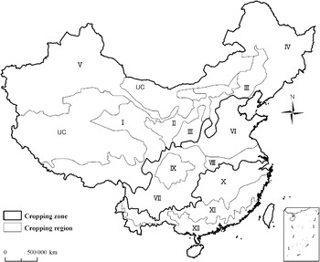
In agriculture, significant differences in the agricultural production conditions within countries reflect socio-economic conditions and differences in natural production resources, production risks and limitations. According to the dominant crop harvest times on the same land in one year, China was divided into three cropping zones that were dominated either by a single-cropping system, a double-cropping system or a triple-cropping system. These were further divided into 12 cropping regions, based on the geographical and climatic conditions at the beginning of the 1980s (Liu et al. Reference Liu, Han and Qu1987) (Fig. 1).
Distribution of the 12 cropping regions and the three cropping zones in China (Liu et al. Reference Liu, Han and Qu1987). (I) Qinghai−Tibet Plateau region with single cropping of cryophilic crops, (II) region of inner Mongolia plateau and along the Great Wall with single cropping of cryophilic crops with a semiarid climate, (III) Loess plateau region with single cropping of temperate crops with frequent drought, (IV) Northeast plain and hills region with single cropping of temperate crops with a semi-humid climate and (V) Northwest region with irrigated single and limited double cropping with an arid climate. The regions that belong to the DC are as follows: (VI) Huang-Huai-Hai plain and hill region with irrigated double cropping and dry land single cropping; (VII) Southwest region of plateau and mountains with double cropping of rice paddy and single cropping of rain-fed slope fields; (VIII) Jiang-Huai plain and hill region with double cropping of wheat and rice or limited triple cropping of wheat, early rice and late rice; and (IX) Sichuan Basin region with double and limited triple cropping both in rice paddy and rain-fed hills. The remaining regions belong to the TC and are as follows: (X) Plain and hills region of the middle and lower reach of the Yangtze River with triple and double cropping of rice paddy, (XI) Southeast hill and mountain region with double and triple cropping of rice paddy and rain-fed hills and (XII) Southern coast plain and hill region with late maturing triple cropping of thermophilic crops. In contrast to cropping, grazing dominated the northwest and Qinghai−Tibet Plateau regions (UC).

The cropping zones were classified by climatic conditions and water availability. The accumulated temperature above a mean daily temperature of 0°C (AT0) was the main indicator of potential multiple cropping as follows: for single cropping, the threshold was AT0<4000–4200 day-degrees; for double cropping, areas with 4000–4200<AT0<5900–6100 day-degrees were suitable; and for triple cropping, areas with 5900–6100<AT0 day-degrees were suitable. Furthermore, among the 12 cropping regions, the regional climatic conditions, such as the duration of the period with a mean temperature above 10°C, the duration of frost-free temperatures, the annual precipitation and the seasonal precipitation, were taken into account. Within each region, the planting time, harvest time, crop pattern and input level were relatively stable because of the similar climate and topography. Therefore, a cropping region was chosen as the unit in which to evaluate the spatial distribution and temporal change in the ALUI.
Definition and assessment of ALUI
There are two types of land use intensity: the intensity of land use in a certain area (FAO 2000; Yu et al. Reference Yu, Zeng, Yang, Hu, Lin, Che and Zheng2010) and the intensity of land use for a certain land category (Stoate et al. Reference Stoate, Boatman, Borralho, Rio Carvalho, De Snoo and Eden2001), such as agricultural land and marginal grasslands. The present study investigated ALUI, which is the type of land use intensity for a certain land category.
Various types of landscape disturbances are caused by human activities. Therefore, the measure of land use intensity change is not exclusive, especially for a single land use type. Generally, intensity is characterized by inputs and outputs against constant units of land area and time (Turner & Doolittle Reference Turner and Doolittle1978; Björklund et al. Reference Björklund, Limburg and Rydberg1999; Shriar Reference Shriar2000; Baessler & Klotz Reference Baessler and Klotz2006; MacLeod & Moller Reference MacLeod and Moller2006). The present study focused mainly on the input intensity. Because intensity is related to the annual cropping specialization of the farms (Baessler & Klotz Reference Baessler and Klotz2006), the simplest example of agricultural intensification involves an increase in cultivation length in one year. In some intensive agricultural systems with multiple cropping cycles in one year, there is little or no fallow time (Keys & McConnell Reference Keys and McConnell2005). In the present paper, the ALUI was defined by the following two factors: the application of inputs to arable land, such as capital, labour, energy and skills and the duration of disturbances to gain more yield, including the duration of cultivation and the frequency of cropping in the context of the annual cropping cycle.
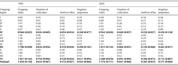
Water and fertilizer are the most significant contributors to Chinese farm practices (Deng et al. Reference Deng, Huang, Rozelle and Uchida2006; Chen Reference Chen2007). The present study selected the irrigation proportion (the ratio of areas with irrigation to the total arable land) and the use of mineral fertilizer (tonnes per hectare) as the proxy for application of inputs to arable land. The duration of cultivation (days per year of crop cover) and the multiple cropping index (the ratio of harvested area to the physical area on which crops were grown in an annual cropping cycle) were used as the proxy for the duration of disturbances. The relative ALUI was calculated for each cropping region, with the four indicators defined by information entropy approach (Zhang et al. Reference Zhang, Yang and Li2006). The method used attempted to integrate all of the indicators into one index to simplify the observation. Both the ALUI score and its change in each region were analysed for 1985 and 2005 (Table 1).
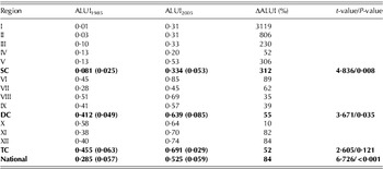
Indicators of ALUI in China for 1985 and 2005. Cropping index refers to ratio of harvested area to the physical area on which crops were grown in an annual cropping cycle; duration of cultivation refers to proportion of crop covering days per year; irrigation proportion refers to ratio of area with irrigation to total arable land

SC, single-cropping zone; DC, double-cropping zone; TC, triple-cropping zone. The values in bold are the means and s.e. of data collected in SC, DC, TC and national.
The ALUI score was derived as follows:
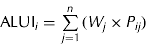
where W j is the weight factor derived from indicator j in cropping region i, and P ij is the standardized value generated from the raw data. The indicator weight W j was used to evaluate the importance of each indicator. The resulting indicator scores were applied to identify the degree of ALUI among different years and regions. A high ALUI value represents a relatively high intensity, and a low ALUI value represents a relatively low intensity.
The weight of each indicator was determined by the information entropy method as follows:
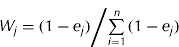
where e j is the information entropy. It is calculated as follows:
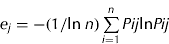
where P ij is calculated using the following equation:
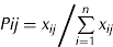
where x ij is the value of indicator j for cropping system i (i=1, 2, …, n).
Finally, the growth rates for the ALUI in each region during the study period were calculated as follows:

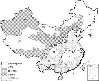
where ΔALUIi is the growth rate of the ALUI from year n to year (n+1) in cropping system i. A positive value indicates that the ALUI increased during the study period, and a negative value indicates that the ALUI decreased. Increases of 0–50% have been here defined as low increases in intensity, increases of 50–100% as medium increases in intensity and increases >100% termed high increases in intensity. A comparison of the overall ALUI between the two years studied was carried out by a paired two-sample t-test after arcsine transformation of the data. The same method was used to separately determine the significance of the ALUI changes for each of the three cropping zones between 1985 and 2005. All significant tests used P=0·05 as the critical level for significance and calculations were performed using the JMP 8.0 statistical software (SAS Institute 2009).
RESULTS
Distribution of ALUI in China
The ranking of indicator weight showed that in 1985 fertilizer had the largest impact on intensity, followed by irrigation, duration of cultivation and cropping index. In 2005, irrigation had the greatest influence on intensity, followed by cropping index, fertilizer and duration of cultivation. The applications to arable land made a large contribution to ALUI both in 1985 and 2005, but the duration of disturbances made a growing contribution to ALUI from 1985 to 2005.
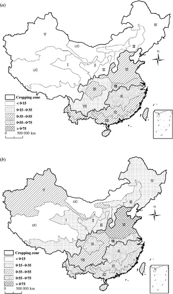
The land use intensity had a distinct distribution throughout the country (Fig. 2). The intensity increased from the north to the south in both 1985 and 2005. The areas of high-intensity scores (>0·35 in 1985 and >0·55 in 2005) were located mainly in central and eastern China, and the areas of low-intensity scores were located in western China. A comparison of the relative-intensity scores of the 12 cropping regions revealed that area with the highest-intensity score in 1985 (0·58) was located in the lower reaches of the Yangtze and Huai Rivers (X), and the area with the highest-intensity score in 2005 (0·85) was further north in the Huang-Huai-Hai plain (VI). The area with the lowest intensity in 1985 (0·01) was the Qinghai–Tibet Plateau region (I), and in 2005 the lowest intensity (0·20) was found in the northeast plain and hills region (IV).
(a) Spatial distribution of ALUI in China in 1985 and (b) spatial distribution of ALUI in China in 2005.

Regional differences in ALUI changes
The ALUI scores increased from 1985 to 2005 (1985: mean±s.e.=0·285±0·057; 2005: mean±s.e.= 0·525±0·059; paired t-test, t=6·726; P<0·001) and ranged from 0·01 to 0·58 in 1985 and from 0·20 to 0·85 in 2005 (Fig. 2, Table 2). The differences in the relative intensity became greater within the country. A pattern of increasing ALUI in planting areas throughout China was observed from 1985 to 2005, and the change in intensity decreased from the north to the south, but with an average increase of 78%.
Spatial patterns of ALUI growth rate of China from 1985 to 2005.

Changes of ALUI in China for 1985 and 2005

SC, single-cropping zone; DC, double-cropping zone; TC, triple-cropping zone. The scores indicate the relative degree of intensity among different years and regions. The values in bold are the means and s.e. of data collected in SC, DC, TC and national.
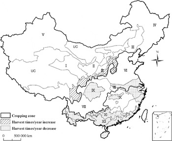
The ALUI scores in the single-cropping zone increased significantly (1985: mean±s.e.=0·081± 0·025; 2005: mean±s.e.=0·334±0·053; paired t-test, t=4·836; P=0·008) (Table 2). The intensity increased sharply between 1985 and 2005 in the Qinghai− Tibet Plateau (cropping region I) (by 3119%) and in three other single-cropping regions (cropping regions II, III and V), with an average increase of 312% (Fig. 3). The intensification of arable land use in the single-cropping zone was strongly associated with a more than 4-fold increase in fertilizer use and approximately 2-fold increase in the land area with irrigation facilities (Table 1). Increasing ALUI scores were also associated with increasing duration of disturbances. The data collected from the survey in cropping region IV indicated that in some fields along the current margins for temperate crop production, the growing period of rice was extended by 15–20 d and the duration of wheat cultivation was also extended by 20 d, with an earlier sowing in spring. In some fields along the boundary between single and double cropping, the duration of wheat cultivation was shortened by c. 20 d from 1985 to 2005 because of late sowing in the autumn and early harvest in the summer. Then maize could be planted in these fields after the wheat harvest, instead of the traditional rotation system of spring maize and winter wheat. Correspondingly, the boundary between single- and double-cropping areas was shifted to the north by c. 2–4° (Fig. 4), which indicated that more areas were considered suitable for multiple cropping and allowed intensive cropping.
Spatial change patterns of cropping systems in China from 1985–2005.

In contrast to the dramatic increasing intensity of land use in regions dominated by a single-cropping system, the ALUI in multiple cropping regions increased more slowly at about 50% between 1985 and 2005. The increase was especially low in the lower reaches of the Yangtze River (cropping region X, 10%) and the Jiang-Huai River (cropping region VIII, 35%), and in the Sichuan Basin (cropping region IX, 39%) (Fig. 3). There was a significant change in the ALUI scores between 1985 and 2005 in the double-cropping zone (1985: mean±s.e.=0·412±0·049; 2005: mean±s.e.=0·639±0·085; paired t-test, t= 3·671; P=0·035). However, there was no significant change in the ALUI of triple-cropping zone (1985: mean±s.e.=0·455±0·063; 2005: mean±s.e.=0·691± 0·029; paired t-test, t=2·605; P=0·121). The index showed a small increase of fertilizer input and area with irrigation, both in the double-cropping zone and in the triple-cropping zone, over the last two decades (Table 2). The county-scale survey data on cropping systems showed that 289 counties accounted for 0·28 of all land in multiple cropping regions that lost one cropping per year in the regions of China dominated by multiple cropping (Fig. 4). This contributed to a decline in the duration of cropping. This loss occurred in the regions along the east and Southeast coasts and in central China, including the Jiang-Huai plain (cropping region VIII), the Sichuan Basin (cropping region IX), the Yangtze River (cropping region X), southern China (cropping region XII) and Southeast China (cropping region XI). According to the survey, triple cropping in the field was seldom practiced in these regions in 2005; annual double cropping being used instead. Some fields were even reduced to one cropping per year, and the duration of cultivation declined markedly. For example, in Southeast China (cropping region XI), a triple-cropping system of early rice/late rice/winter wheat was carried out in 1985, but a system with two successive crops of rice or rice/vegetables was the prevailing practice in 2005. The duration of cultivation was shortened by c. 90 d.
DISCUSSION
Relative roles of natural and socio-economic drivers of ALUI and cropping system changes
Chinese farmers are known for their intensive use of land and now rely more than ever before on irrigation, fertilizers (organic and inorganic), seeds, machinery, pesticides and mulch film for soil moisture retention. For instance, farmers did not use any commercial fertilizers in China in 1949 (Zhen et al. Reference Zhen, Zoebisch, Chen and Feng2006), but in 2005, the average amount of mineral fertilizers used was 318 kg/ha (including nitrogen, phosphorus and potassium): 2·5 times more than the world average (Table 1). Agriculture is strongly influenced by the availability of water (Olesen & Bindi Reference Olesen and Bindi2002). Irrigation is the key to land use intensification in drought-prone regions or where a seasonal low rainfall regularly constrains the stock-carrying capacity. The area of irrigation use was increased by 25% over the last two decades. At present, c. 0·80 of the total national water consumption is for irrigating 0·45 of the arable land (Li et al. Reference Li, Zuo, Tschirley, Webb and Morton1997). The Huang-Huai-Hai plain (cropping region VI), which has a dominant double-cropping system of winter wheat and summer maize, suffers severely from water shortages. Recently, several farmers in Tianjin attempted to grow drought-tolerant crops, such as cotton and maize, instead of wheat and rice to respond to the water scarcity. In one year, they even planted only a single spring maize crop. The adoption of a series of technologies (e.g. breeding improvements, agronomic improvements, irrigation measures, fertilizer and machinery) has contributed to the enhancement of land use intensity and improvement in land productivity (Zhen et al. Reference Zhen, Routray, Zoebisch, Chen, Xie and Cheng2005). Given the limited data, only four indicators were considered to empirically express the ALUI change in this study. Other factors, such as labour, which are important to intensity, were not covered.
The highly diverse natural and socio-economic conditions in China have caused land use changes to have differential impacts across the country (Verburg et al. Reference Verburg, Chen and Veldkamp2000). One of the main factors underlying the regional differences in ALUI changes was differing levels of economic development. With China's uneven economic development over the last two decades, the income disparities between rural and urban populations and between western and eastern provinces have become the highest in the world (Yang & Li Reference Yang and Li2000; Chang Reference Chang2002). This disparity has been attributed to the preference of farmers to leave the area to work in an urban area and earn more money. In regions with higher levels of development, farmers have more off-farm work opportunities and depend less on farming. Therefore, the labour-intensive paddy fields in multiple cropping regions, such as the lower reaches of the Yangtze River (cropping region X) and southern China (cropping region XII), the cropping system has shifted to non-paddy fields or decreased to one cropping per year, and the ALUI scores have slowly increased.
Agricultural production is sensitive to climate changes. It is predicted that climate change will increase not only seasonal air and soil temperatures but also the variability of rainfall patterns (Patil et al. Reference Patil, Laegdsmand, Olesen and Porter2010). In northern Europe, temperatures have been increasing over the past few decades, which has led to earlier start dates of crop stages and even shortening the duration of stages for certain species (Olesen & Bindi Reference Olesen and Bindi2002; Dalla Marta et al. Reference Dalla Marta, Grifoni, Mancini, Storchi, Zipoli and Orlandini2010; Eitzinger et al. Reference Eitzinger, Orlandini, Stefanski and Naylor2010). Climate change has been suggested to have a great impact on cropping system changes in China (Thomson et al. Reference Thomson, Izaurralde, Rosenberg and He2006; Yang et al. Reference Yang, Lin, Ma, Ju, Guo, Xiong, Li and Xu2007; Deng et al. Reference Deng, Zhang, Pu, Liu, Guo, Wang, Zhao and Wang2008). It was found in the present study that suitable single-cropping areas and multiple cropping areas were expanded to the north. There have been reports of a northward shift of the boundaries between double cropping and single cropping driven by climate change (Deng et al. Reference Deng, Zhang, Pu, Liu, Guo, Wang, Zhao and Wang2008), but this was not explored in the present study. The expansion of areas suitable for single or multiple cropping and the increase of the length of growing period contribute to the potential for intensive cropping.
Sustainable land use and China's future cereal production
A better understanding of the spatial correspondence of ALUI based on cropping systems will help to determine whether the current land use is reasonable or not. Cropping systems must be sustainable in that they must maintain future production potential and not inflict unacceptable long-term damage to other ecosystem components (Shriar Reference Shriar2000). Only land use intensity that is suitable to the production capability of the land can be sustainable. It is necessary to develop and foster an agricultural system aimed at sustainable intensity that will produce more food from the same area of land while reducing the environmental impacts (Shriar Reference Shriar2000; Godfray et al. Reference Godfray, Beddington, Crute, Haddad, Lawrence, Muir, Pretty, Robinson, Thomas and Toulmin2010). Chinese farming has evolved over thousands of years to intensively exploit the prevailing environmental conditions; typically, farmers can use a plot year after year and harvest from it several times each year. It is not known if the farming has already exceeded its potential. In the present paper, intensity was measured based on applications to arable land and duration of cropping. Thus, it was difficult to evaluate the extent to which the intensity was sustainable; the present study was only able to explore the tendency of the ALUI. Future studies should take output as a measurement to evaluate the gap between the current yield and potential.
According to Zhang et al. (Reference Zhang, Zhang, Zhang, He, Zhang, Wu and Kong2008), the Huang-Huai-Hai plain (cropping region VI), the northeast plain (cropping region IV), the middle and lower reaches of the Yangtze River (cropping region X) and the Sichuan Basin (cropping region IX) have the highest gross cereal potentials, accounting for 0·24, 0·15, 0·14 and 0·10, respectively, of the total cereal potential of China. However, it was found in the present study that three of these four regions (VI, IX and X) experienced a slower increase in ALUI than the national average, and these three regions also experienced a decrease in planting area. Other studies have shown that most of the high-quality land is located in the southern and eastern regions of China, especially near the Yangtze River (Tong et al. Reference Tong, Hall and Wang2003; Zhang et al. Reference Zhang, Yu, Li, Zhou and Zhang2007). A decrease in planting area and a low increase in ALUI were found for this area, which encompasses 0·10 of the arable land in China. It is difficult to compensate for this loss with the reclamation of land of the same quality and quantity in other regions. The vast loss of planting areas and the low ALUI growth rate should be of great concern to the government. China now regulates and controls the conversion of land from agricultural to non-agricultural use by a comprehensive series of measurements, and little attention is paid to the loss in planting area and the slow growth in the ALUI.
Low cereal potentials were found in the Qinghai− Tibet Plateau and Intersecting Coteaus regions (cropping regions I and UC), these regions account for only 0·0023 and 0·0029, respectively, of the total national cereal potential (Zhang et al. Reference Zhang, Zhang, Zhang, He, Zhang, Wu and Kong2008). The present study shows that these areas experienced a great increase in ALUI between 1985 and 2005. The negative impacts of the overuse of water in agriculture combined with the influence of a changing climate have been well illustrated in northwest China (Royal Society 2009). To ensure a sustainable development and better ecological conservation, China will continue its drive for land conservation in the west in the coming decades (Chen Reference Chen2007).
Meanwhile, cash crops, which are profitable and economically attractive to farmers, became popular in 2005. Increased planting areas of vegetables, oilseed rape, cotton and other cash crops decreased the dependence on cereal production in the local cropping systems. Oilseed rape has recently become a staple cash crop in central China due to the greatly increasing demand for energy with specialized rice and oilseed rape cropping systems being gradually developed (Yin et al. Reference Yin, Liao, Yu and Wang2010). These changes may result in an increase in the share of cash crops within the cropping system throughout the prime cereal cropping areas.
The main conclusions from the present study are that there was a clear ALUI distribution throughout the country in 2005, with ALUI increasing from the north to the south. The highest ALUI was found in the lower reach of the Yangtze and Huai Rivers in 1985, but it had shifted northwards towards the Huang-Huai-Hai plain by 2005. The ALUI increased significantly from 1985 to 2005, but the proportional increase was greater in the north than the south. The great increase in intensity in the northern single-cropping regions was strongly associated with the rapid increase of inputs and extended duration of cultivation. In contrast, a decrease in the duration of cultivation and planting area slowed the ALUI increase in southern multiple cropping regions, which were concentrated in the coastal and economically developed areas that also have more fertile soils and climates suitable for multiple cropping. It is difficult to find land reclamation areas of similar quality and quantity in other regions to compensate for this loss.
By giving top priority to agriculture, China has achieved great success in feeding its people in the past. China has balanced the use of its land resource for economic development, cereal production and ecological conservation. Until the present study, there has been insufficient data on the temporal trend. The current trend of agricultural practices in China implies that there will be continued intensive land use for at least another decade unless there are major changes based on scientific innovation. More effective strategies, such as policies, institutions and projects, are needed to counteract the negative aspects of environmental and socio-economic changes and to promote sustainable food production and land management. In the above discussion, several points were only observations and hypotheses. Thus, a more quantitative analysis is needed.
This research was supported by the National Natural Science Foundation of China (Grant No. 30771261, 30370824) and the National Key Technology Research and Development Program of China (Grant No. 2006BAD20B07). We are grateful to Professor Zheng Dawei for useful comments and suggestions on this study. All anonymous reviewers and editors are thanked for their contributions in improving the manuscript.